Stream 4 BEYOND THE CITY: From CONTESTED_CITIES to Global Urban Justice Article nº 4-002 - Contested Cities
←
→
Page content transcription
If your browser does not render page correctly, please read the page content below
INTERNATIONAL CONFERENCE
From CONTESTED_CITIES to Global Urban Justice

                  Stream 4

               Article nº 4-002

              BEYOND THE CITY:
GENTRIFICATION AND EXCLUSION ON THE COASTAL
                 MARGINS

                JOHN LEO RYKS
             RENEE FRANCES SHUM
BEYOND THE CITY:
            Gentrification and exclusion on the coastal margins

                                                                  Dr John Leo Ryks
                  National Institute of Demographic and Economic Analysis (NIDEA)
                            University of Waikato, Hamilton, Aotearoa New Zealand
                                                                  ryks@waikato.ac.nz

ABSTRACT
This paper presents a case for a geography of gentrification with a focus on
coastal settlements in Aotearoa New Zealand. With a large proportion of the
population living near the coast, the last 15 years has seen many coastal
settlements experience unprecedented development and, outside of coastal
urban areas, this rapid development has brought with it rising property prices
and a changing demographic profile in terms of the mix of long-term permanent
residents and an influx of temporary and absentee landowners.
In this paper, we argue for a new form of gentrification occurring in isolated
coastal settlements, located beyond city commuter belts, and occurring within
well-established coastal communities that have historical attachment to places.
We present an exploratory approach and framework for measuring rates of
gentrification across these settlements.
Findings from the research showed distinct patterns of gentrification, including
complex spatial variation across settlements. Increases in household income,
professionalisation, the number of tertiary-educated, renting and the number of
empty dwellings, often corresponded with a decline in the resident Māori
population (Māori are the indigenous peoples of Aotearoa New Zealand) and
lower levels of deprivation as measured by the New Zealand Deprivation Index.
Our mapping of coastal settlements reinforces a new and unique form of
gentrification. It is one that occurs outside of major cities and towns and is
markedly different to processes of coastal (sub)urbanisation found elsewhere in
Aotearoa New Zealand. It is also distinct from the building of new wealth and
resort enclaves in other postcolonial countries in the Global South. The critical
analysis and measurement of gentrification in isolated coastal settlements is an
area that would benefit from further research and connects with calls for new
geographies of gentrification to widen the spatial lens of gentrification studies.

KEYWORDS: gentrification, coastal settlements, Aotearoa New Zealand, Māori.

                                                                                 -1-
                                 Article nº 4-002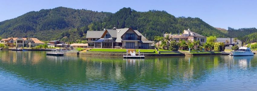
1. INTRODUCTION
The elongated shape of Aotearoa New Zealand1‟s two major islands gives the country a
coastline in excess of 10,000 kilometres, a length that is significant in relation to its overall
landmass. With a large proportion of the population living near the coast, the last 15 years
has seen many coastal settlements experience unprecedented development as a discourse of
coastal utopia is marketed to those looking to purchase holiday homes and wanting
counter-cultural lifestyle experiences (Collins, 2013; Freeman and Cheyne, 2008; Peart,
2009). Outside of coastal urban areas, this rapid development has brought with it rising
property prices and a changing demographic profile in terms of a mix of long-term,
permanent residents and an influx of temporary and absentee landowners.
In this paper we argue that the coastal development phenomenon is driving a new form of
gentrification. By adopting a post-colonial view of this phenomenon we present a form of
gentrification that occurs in isolated coastal settlements located across and beyond city
commuter belts, and characterised by forms of (often) radical change occurring within well-
established coastal communities. For our study we focus on select coastal settlements
within the Waikato and Bay of Plenty regions of Aotearoa New Zealand and present a
typology of gentrification that is grounded through a number of case studies. Our specific
aims are to:
discuss emerging forms of gentrification and new approaches to measuring
gentrification;
discuss the differences between gentrification and urbanisation in the context of
coastal development in Aotearoa New Zealand;
to present a typology for measuring gentrification within coastal settlements;
ground this typology through a number of vignettes or case studies that profile
select coastal settlements; and
discuss areas for future research.
2. NEW FORMS OF GENTRIFICATION
There is a recognised lack of consistency in terms of how gentrification and displacement
are defined and conceptualised (for example, see Barton, 2016; Lees, 2012; Shaw (2008);
Shaw & Hagemans (2015); Slater, 2011; Zuk, et al., 2015). According to Zuk et al. (2015:
34), this is based on:
1. inconsistent definitions and operationalization of the terms gentrification and
displacement;
2. differences in the definitions of a comparison group and controls to calculate and
compare displacement rates;
3. the time-scale of analysis that may not capture the full processes of neighborhood
change; and
4. ambiguous criteria against which to determine the significance and meaning of
research results.
Connected to the first point above, there have been calls to reappraise gentrification
research and explore other geographies of gentrification (Phillips, 2004; Smith, 2002).
Phillips argues that these new forms may not be full commensurable with traditional
1Aotearoa (translated as „land of the long white cloud‟) is one of the original names for New Zealand. We follow a
common practice of using both names.
-2-
Article nº 4-002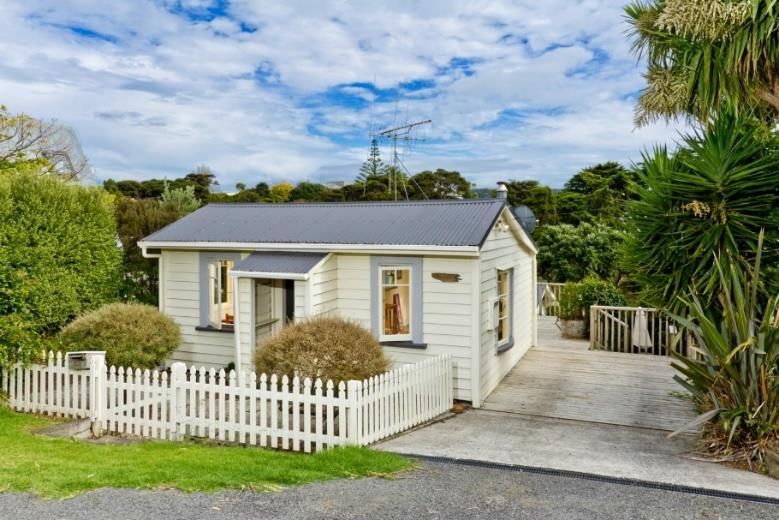
definitions of gentrification in urban areas, but that complementary accounts of them can
be constructed, and that a key task may well be to tease out the differences which are
embedded within, as well as between, particular spatial contexts.
We build on the work of Lees (2012) and Phillips (2004) to present a new form of
gentrification taking place. While Lees‟ focus is on a comparative urbanism, she points to
the need for the Global South to engage in a less Eurocentric, post-colonial view of
gentrification where colonial legacies and neo-colonial realities are linked to the
displacement of vulnerable populations. She also argues for a geography of gentrification
where consideration must be given to both the spatial and temporal dimensions of
gentrification.
Phillips (2004) presents a case for the gentrification research to move beyond a focus on
the inner city and instead look more to geographies of gentrification that have some
commensurability with rural as well as urban spatialities. Collins (2013) warns against this
widening of the spatial lens in that it may lead to broad definitions of gentrification that
undermine the usefulness and distinctiveness of the concept. However, it has also been
argued that the broadening of the concept may not render it meaningless but rather that it
properly refers to the conflating of contingent and necessary relations (Clark, 2005).
Our focus on the gentrification of select coastal settlements follows the work of Lees
(2012) in taking the focus away from a Euro-American perspective of gentrification to look
at understanding gentrification within coastal Aotearoa New Zealand as a form of neo-
colonialism. And we build on Phillips‟ (2004) work by widening the spatial lens to provide a
new geography of gentrification that extends beyond the city and the processes of
urbanisation by looking at the development of coastal settlements as a unique form of
gentrification.

2. MEASURING GENTRIFICATION
A diverse range of approaches to measuring gentrification have been employed. Most
notably there is a dichotomy in the spatial scale of inquiry in relation to the measurement
of gentrification. For example, Hammel and Wyly (1996: 248) maintain that “there is a
substantial dichotomy between neighbourhood-based studies that provide little
comparability between different settings, and extensive census-based analyses that lack any
verification of results as scholars fail to integrate fieldwork with rigorous analysis of census
data and may not be able to distinguish gentrification from other types of neighbourhood
change”. Hammel and Wyly (1996) recognise that it is rare for gentrification measurement
models to use these two approaches to measurement and analysis together within a study.
Despite the potential benefits of utilising these two approaches together, the theoretical
and methodological underpinnings of each approach do not lend themselves to
collaboration.
Studies that utilise census data to identify neighbourhood change via proxy measures of
gentrification use measures such as rental inflation, tract-level income gains, or increases in
professionalization or tertiary (college) educated populations. Freeman et al. (2005: 4) for
example, note that the “early stages of gentrification are characteried by influxes of college-
educated but relatively low paid professionals”.
A central theme of inquiry within gentrification research and measurement is the
displacement of incumbent residents as indicated by a declining of the working class
population. For example, Atkinson (2000) uses longitudinal individual-level data to
                                                                                            -3-
                                       Article nº 4-002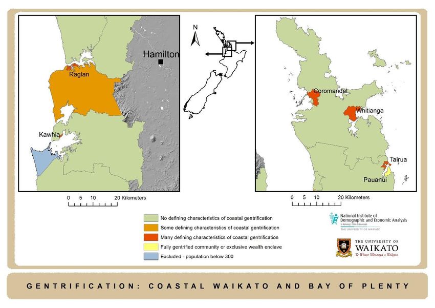
examine the migration of gentrifiers into, and the displacees out of, gentrifying
neighbourhoods. Vigdor et al. (2002) in analysing the American Housing Survey data to
measure displacement from gentrifying zones, classified gentrified zones based on the
relative increase in the college-educated share of the population. Freeman and Braconi
(2004) classified gentrified areas based on their knowledge of local neighbourhood change
and through supporting data documenting demographic and socioeconomic shifts
consistent with gentrification. McKinnish et al. (2010) compared demographic shifts in
low-income census tracts that experienced large increases in average family income to
comparable tracts that did not experience such an increase. Despite gentrification-induced
displacement being notoriously difficult to quantify, Davidson (2008), Lees (2008),
Newman and Wyly (2006) and Slater (2011), maintain that exclusion of low-income
households (caused by gentrification) is inequitable and deeply disruptive. Butler and
Hamnett (2009) and Hammel and Wyly (1996) note that despite the depth of literature on
the various social and economic changes that result from gentrification, there still remains
disagreement on the nature and range of variables and thresholds that provide the most
reliable indicators.
In using more detailed, disaggregated data to understand displacement in inner London,
Atkinson (2000) combined cross-sectional and longitudinal census data, using increases in
the number of professionals and managers as proxy measures of gentrification and
decreases in the number of „vulnerable‟ residents, such as residents that were of colour,
working class, unskilled, renters and unemployed as measures of displacement. From his
analysis, Atkinson established strong links between a rise in gentrification and displacement
of vulnerable groups. Atkinson was one of the first to focus on specific vulnerable
populations in his operationalized definition of displacement. Yet he cautioned that the
study at the large ward and district scale with “noisy” data does little to provide a deeper
understanding about the impacts of displacement, for which he suggests more qualitative
research. Similarly, Slater (2011: 580) recognises that “the absence of qualitative accounts of
displacement is striking and shocking when juxtaposed with quantitative measures, or with
all those accounts of the trials and tribulations of the new middle class”.
Another key limitation Atkinson (2000) identifies in current approaches to measuring
gentrification and displacement is confusion around suitable comparison groups or
controls and whether displacement from poor gentrifying neighborhoods should be
compared to non-gentrifying poor neighborhoods (e.g. Freeman, 2005 and Vigdor et al.,
2002), or to city-wide averages or more stable neighborhoods in general (e.g. Newman and
Wyly, 2006). As Zuk et al. (2015: 35) identify, these comparisons become critical as “they
not only provide context against which to evaluate results, but also reveal belief systems
about our normative understandings of how neighborhoods should function”.

3. COASTAL GENTRIFICATION AND AOTEAROA NEW ZEALAND
Coastal gentrification has its own unique form given the discourse of coastal utopia that
features in the construction and development of coasts in the West. For example,
Marjavaara (2007a) presents an analysis of the unique nature of coastal gentrification with a
focus on three island communities in the Stockholm archipelago. Marjavarra (2007: 27)
argues that “local price inflation of dwellings, generated by external demand for second
homes in the area is created as buyers and owners of second homes in attractive areas are
often recruited from upper-class segments of society who have a higher socio economic
status than the permanent residents”. In exploring coastal gentrification in Aotearoa New

                                                                                           -4-
                                       Article nº 4-002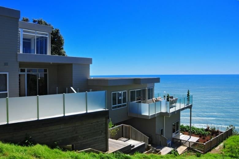
Zealand, Freeman and Cheyne (2008) discuss how the development of coastal communities
have increased the socio-economic disparity between the newcomers and the original
community which has in turn seen the decline of the permanent population. Freeman and
Cheyne introduce the reader to some of the economic and social drivers of coastal
development in Aotearoa New Zealand and go on to link coastal development to the
process of gentrification. Specifically, they state that “if we take the generally accepted
definition of gentrification as „the production of space for, and consumption by, a more
affluent and very different incoming population‟, then the process of gentrification is alive
and creating a new geographic landscape in New Zealand” (Freeman and Cheyne, 2008:
58). They go on to argue that gentrification and the sea change process partially explains
the extent of this development but also note that there is a lack of attention towards
indigenous communities in the wider planning literature in New Zealand.
Counter to this argument, Collins (2013) argues that new developments within coastal
communities do not constitute gentrification but rather, are forms of sub-urbanisation
because the original community only experiences secondary displacement through the
construction of new building developments, attracting investors and pushing up the
property prices, which local communities can then no longer afford. Collins (2013) suggests
that residential development in coastal Aotearoa New Zealand may be better understood
simply as characteristics of a buoyant real estate market and goes on to suggest that the
central elements of gentrification are absent in the coastal countryside, such as restoration
and reuse of the built environment. He notes that “a highly visible component of coastal
development in New Zealand has been the demolition of modest baches2 from previous
eras, and their replacement with large modern homes, which does not follow the key tenet
of gentrification of „doing up‟ the traditional. As coastal land values soared, retaining of the
traditional houses was seen as „untenable‟ as the value of their „low key ambience‟ was
traded and upgraded for the cultural expectations of comfort, privacy and increased living
space requirements” (Collins, 2013: 113-114). Although Freeman and Cheyne (2008)
describe the investment and in-migration of the coast as gentrification, Collins (2013)
asserts that this conflates gentrification with increasing prices and decreasing affordability.
Furthermore, Collins (2013) posits that the detached housing, new building construction
and Greenfield subdivision development in coastal areas is not accounted for within a
framework of gentrification. This is because displacement requires the direct displacement
of the incumbent working-class population. And whilst new building developments reduce
housing affordability, Collins (2013) notes that socio-economic change may occur due to
shifts in occupational structure or from the movement of relatively affluent households
into new building stock.
Following Freeman and Cheyne (2008), we focus our analysis on coastal communities and
settlements within Aotearoa New Zealand and expand on the understanding that the
transformation of coastal New Zealand is directly connected to a process of gentrification.
More than a form of urbanisation, the development process driving the marketing of
desirable and exclusive coastal sections, coupled with local and central government
planning that favours certainty and well-defined, contained coastal zones, have
compounded effects for communities with traditional links to the coast. After Ryks (2014),
we argue that the high value and demand placed on specific, accessible „cadastral‟ parcels of
private coastal property dictates that much of Aotearoa New Zealand‟s coast is divided
according to constructs of wealth and desirability. As a way of further understanding these
constructs we explore the use of a typology of gentrification based on the analysis of

2   In Aotearoa New Zealand a bach is a small, very modest permanent home or holiday home.
                                                                                             -5-
                                                  Article nº 4-002
census data and a number of recognised measures of gentrification, and attempt to „ground
truth‟ this analysis with some understanding of the spatial context within which
gentrification is situated. In our analysis, and following Marjavaara (2007a), Marjavaara
(2007b), Marjavaara & Muller (2007), Muller, & Hogendoorn (2013), Keen and Hall (2004)
and Walters (2014), one of the key distinctions between urbanisation and gentrification in
coastal settlements is the number of second or holiday homes. We measure this in the
Aotearoa New Zealand context through the number of empty dwellings in those
settlements.
4. METHODS
Previous studies have relied predominantly on qualitative approaches to understanding the
economic and cultural impacts of the gentrification process occurring within coastal
settlements in Aotearoa New Zealand. For this paper we present an exploratory approach
and framework for measuring rates of gentrification by using national census data and GIS
to map coastal settlements undergoing different stages of gentrification. The use of
aggregate data to understand gentrification and displacement has been considered
problematic due to a lack of closeness to the nature of these processes (Zuk et al., 2015),
but through the novel development of a typology of gentrification we consider income,
occupation, education, renting demand and second home ownership as measures for
showing rates of gentrification in coastal settlements.
4.1 Developing a typology for measuring gentrification in coastal Aotearoa New
Zealand
Models and frameworks for measuring gentrification have varied significantly according to
the different ways gentrification has been defined and conceptualised. We concur with Zuk
et al. (2015) in recognising that gentrification is multi-faceted and may usefully include
multiple measures through a typology of gentrification. Our typology is based on a range of
recognised proxy measures of gentrification that are based on the wider literature (as
discussed in Section 2 of this paper) and matched with data from the New Zealand Census
of Population and Dwellings over different census periods (typically between 2006 and
2013, but using 2001 data where further trend information was required). Table 1 outlines
the variables used in the study and what each variable shows. Total population and ranges
of empty dwelling counts were used as the primary basis for each level, and then the main
variables used were increases in professionalisation, educational achievement, household
income, the number of empty dwellings (as a proxy measure for the number of
second/holidays homes), and renting.
Table 1. Variables used for measurement typology
Measure Source What does it show?
Total Census Size and overall population profile of coastal
population counts settlements.
Total empty Census Higher counts of empty dwellings are an indicator of
dwelling counts second homes / holiday homes found in coastal
(dwellings found to settlements.
be empty on Census
-6-
Article nº 4-002night and assessed
by the Census Field
Officer to be not
usually occupied)
Increased rate of Census Increase in managers and those in professional
professionalisation employment is used as an indicator of gentrification.
Increased rate of Census Early signs of gentrification are typified by increases
educational in tertiary educated residents.
achievement
Increased Census Increase in higher income earners over time is an
household income indicator of later stage gentrification.
Increased rate of Census Increase in empty dwellings in coastal areas suggests
empty dwellings wealthier absentee landowners buying second or
over time holiday homes.
Increased renting Census Increase in higher numbers of people renting in
coastal settlements with high empty dwelling counts
suggests houses being less affordable as absentee
landowners and new, wealthier migrants buy into
communities.
4.1.1 Units of analysis
For the purpose of this study, we used the Statistics New Zealand Census Area Unit (CAU)
population data from the 2001, 2006 and 2013 censuses. CAUs are the second smallest unit
of dissemination of census data and are aggregations of meshblocks often defining urban
neighbourhoods and suburbs. CAUs were considered the best unit for analysis for this
study as meshblock data (the smallest unit of dissemination) would have produced counts
too small for analysis and could have potentially compromised privacy. For each variable,
differences in either total counts (e.g. total number of empty dwellings) or percentage
changes between census periods (e.g. percentage increases in income levels) were
considered. It should be noted that the data for the non-respondents (census respondents
not responding a valid answer to the question(s) on the census form) are excluded from the
analysis of census data used.
4.1.2 Selection of regions and coastal settlements
The focus of this study was on the Waikato and Bay of Plenty regions in Aotearoa New
Zealand as we considered these two regions would capture a diverse range of coastal
settlements and development. 323 CAUs are contained within these two regions (out of a
total of 2020 CAUs for Aotearoa New Zealand nationally). These CAUs are located across
rural, urban and coastal areas. As the focus for this study was on coastal settlements,
ESRI‟s ArcMap 10 GIS software was used to further reduce the number of CAUs to those
that were adjacent to the coast. Specifically, a spatial query was used to select all CAUs that
were within two kilometres of the coast. This left a total number of 92 CAUs that would be
matched to the gentrification typology described in section 4.1.
4.1.3 Using a gentrification typology and GIS to map gentrification in the Waikato and Bay of Plenty
regions of Aotearoa New Zealand
-7-
Article nº 4-002GIS was used to geographically display the typology of gentrification across Waikato and
Bay of Plenty coastal CAUs. Specifically, separate spatial queries were performed to select
the attributes described in the right-hand column in Table 2. From this, four different map
layers were combined to produce a four-zoned map of coastal gentrification based around
the typology described earlier. CAUs were mapped for the Waikato and Bay of Plenty
Regions that were considered to be displaying either: no defining characteristics of
gentrification, some defining characteristics of gentrification, many defining characteristics
of gentrification, or characteristics of a fully gentrified or planned, exclusive community.
The intention with this approach was not to come up with a list of CAUs that neatly fitted
into set categories, rather the aim was to use the typology and the GIS queries as an
exploratory approach to see if the measures used, and the results recorded, reflected the
realities within those coastal settlements.
Table 2. Queries used to map CAUs to gentrification typology
Gentrification query Gentrification level
Total population is greater than 300 but does not meet any Displaying no defining
of the gentrification criteria below characteristics of
gentrification
Total population is greater than 300 Displaying some defining
Number of empty dwellings account for less than 15 per characteristics of
cent of total dwellings gentrification
Increase in professionalisation (number of managers and
professionals)
Increase in the number of individuals with a higher tertiary
education qualification (Bachelor‟s or higher)
Increase in high income households (defined as households
earning more than $70,000)
but does not fulfil the following measures:
Increase in empty dwellings
Increase in renters
Total population is greater than 300 Displaying many defining
Number of empty dwellings accounts for over 15 per cent characteristics of
of total dwellings gentrification
Increase in professionalisation (number of managers and
professionals)
Increase in the number of individuals with a tertiary
education qualification
Increase in high income households (defined as households
earning more than $70,000)
Increase in empty dwellings
Increase in renters
-8-
Article nº 4-002 Total population is greater than 300 Displaying characteristics
Number of empty dwellings accounts for over 25 per cent of an already gentrified
of total dwellings or planned community
New Zealand Deprivation index3 level is four or less
Median Household Income is more than 45,000 p.a.
4.2 Vignettes of select coastal communities within the region undergoing various
stages of gentrification
Based on the results from the spatial analyses, three coastal settlements were selected and
presented as separate vignettes. Existing literature about the history and development of
these settlements, including previous research undertaken by Ryks (2014) was used as a
basis for developing a narrative for each settlement. The purpose of these vignettes within
our paper was to situate some of our findings within the wider context of coastal
development and provide some „ground truthing‟ of our measures in order to help
distinguish gentrification from other types of neighbourhood change that could otherwise
be occurring (after Hammel & Wyly, 1996). The data and measures introduced previously
within our typology were then highlighted and represented in a three separate radar graphs
for each settlement.
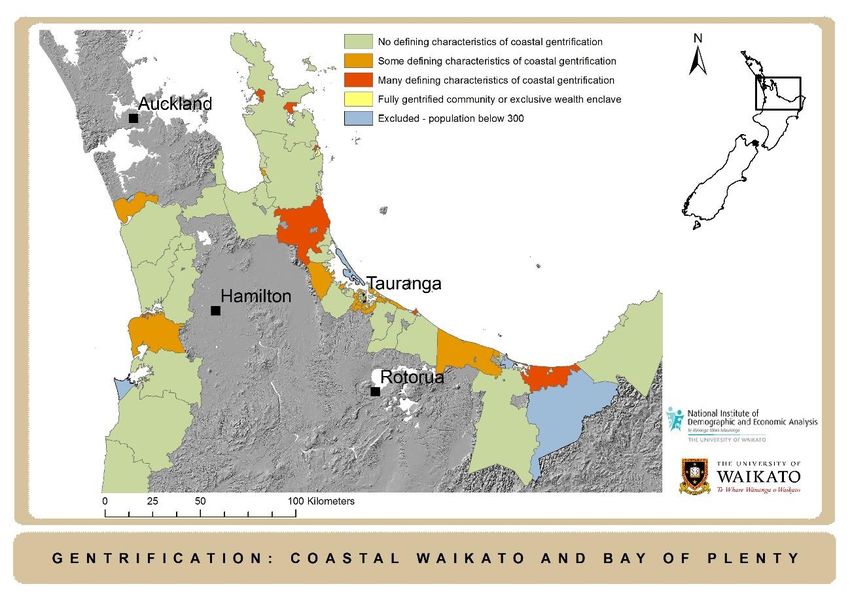
5. RESULTS
5.1 CAUs matching gentrification typology
Distinct differences and complex spatial variations were identified across regions and
individual CAUs using the typology and GIS methods described above. Of the 92 coastal
CAUs in the Waikato and Bay of Plenty region, 52 (57%) were recorded as displaying no
defining characteristics of gentrification, 25 (27%) were recorded as displaying some
defining characteristics of gentrification, eight CAUs (9%) were shown to be displaying
many defining characteristics of gentrification, and two CAUs (2%) were recorded as
displaying characteristics of a planned or gentrified community. Five CAUs (5%) featured
less than 300 residents and were not considered for further analysis. Figure 1 maps each
individual CAU according to the gentrification typology introduced earlier.
Only two CAUs (Pauanui and Ohope) displayed characteristics of a community or
settlement that was already gentrified or planned, exclusive community. Pauanui is a
planned community and this is evident in this level of our typology as it has not had the
same increases in measures over time, rather, it has always featured as an exclusive wealth
enclave since its design and inception. This was measured through its low socio-economic
deprivation level and its extraordinary high levels of emptying dwellings (and therefore
absentee landowners). 81 per cent of homes in Pauanui are empty, so its total population of
750 (as at the 2013 Census) reside in the remaining 19 per cent. While not part of our
formal measurement framework, it is also interesting to note that Pauanui has a very low
Māori population and one which is decreasing. In 2013, only 2 per cent of its total
population was of Māori descent, down from 4 per cent in 2006 (overall Māori make up 15
per cent of Aotearoa New Zealand‟s population). Pauanui also has a decreasing deprivation
3 The New Zealand Deprivation Index combines census data relating to income, home ownership, employment,
qualifications, family structure, housing, access to transport and communications. The index provides a deprivation score
for each CAU from 1 (least deprived) to 10 most deprived. Source: http://www.health.govt.nz/publication/nzdep2013-
index-deprivation. Accessed 26 May 2016.
-9-
Article nº 4-002score (NZDep 2 in 2013, down from NZDep 4 in 2006). The realities of Pauanui as an
exclusive community are discussed further in the next section of this paper.
Ohope (pop. 2844 at the 2013 Census), the other settlement that featured in this level of
our typology, is an example of a settlement that is heavily gentrified. As an outlier to the
larger town of Whakatane, it has a very high median income ($69,000 at the 2013 Census),
low and decreasing levels of socio-economic deprivation (NZDep 3 in 2013, down from
NZDep 4 in 2006) and a growing number of empty dwellings (8.4% in 2001, 13.8% in
2006, 27% in 2013). See Appendix 1 for more trend data for Ohope.
Among the settlements showing many defining characteristics of gentrification, the
settlements of Raglan (pop. 2736), Whitianga (pop. 4368), Tairua (pop. 1227) and
Coromandel (pop. 1503) are of particular interest as they meet all the criteria introduced
earlier but are not directly attached to the growth and urbanisation of larger urban centres.
All are located 40 kilometres or more from the major urban centres of Auckland, Hamilton
and Tauranga and each of these settlements have a significant pre and post-colonial history
and former reliance on primary industry, but have developed into holiday destinations that
increasingly rely on domestic and international tourism. Raglan and Whitianga are two
settlements within this category that are discussed in more detail in the next section of this
paper. All CAUs in this category had increases in numbers of professionals recorded as
living there, increases in numbers of residents that have higher levels of tertiary education,
higher income levels, increased renting activity and increasing numbers of second/holiday
homes. Other CAUs recorded as showing high levels of gentrification, appeared to be
connected to areas of peri-urban growth or in rural lifestyle areas (see Appendix 1 for trend
level data).
CAUs that had some defining characteristics of gentrification were spread across urban
(specifically Tauranga) and rural coastal areas. These areas featured general increases in
rates of professionalisation and educational achievement, but did not have accompanying
rates of increased renting activity, or higher rates of empty dwellings. CAUs that featured as
having no defining characteristics of gentrification were typically larger in geographical size
and with settlements that were more isolated and less heavily populated. For both these
two categories of our typology it harder to separate processes of urbanization, and rural
growth or development from gentrification as there is no consistent trend data across key
measures, such as the number of empty dwellings recorded. Few are considered or
recognised as coastal holiday destinations.
Figure 1. CAUs and settlements mapped to the gentrification typology
- 10 -
Article nº 4-0025.2 Case studies
The typology and analyses presented in this paper are exploratory. Further, as stated in
Section 2, there is often a dichotomy between neighbourhood-based studies that provide
little comparability between different settings, and extensive census-based analyses that lack
any verification of results. While it is beyond the scope of this study to verify our results
through extensive qualitative research, through the following vignettes we ground our
census-based analyses by providing three separate vignettes of the settlements of Raglan,
Whitianga and Pauanui (see Figure 2 for location) to fully understand the context within
which gentrification may be taking place.
Figure 2. Location of select coastal settlements
- 11 -
Article nº 4-0025.2.1 Vignette 1: Raglan
Raglan (Māori name Whaingaroa, meaning „the long pursuit‟)4 is located on the west coast
of Aotearoa New Zealand‟s North Island and 45 kilometres from the nearest major city,
Hamilton. Raglan was first settled by Māori who arrived on the migratory canoe, Tainui.
Europeans settled in 1835 who then begun the large scale conversion of land for
agricultural purposes in the mid-1850s. A large part of land owned by Māori in Raglan was
confiscated by the Crown during the Second World War for use as an airfield. After it was
no longer required, the land was sold to private landowners with some of the land
becoming a golf course. Local Māori had to fight for some 30 years before it was returned
(Photo 1).
Raglan is now supported by a commercial fishing industry, farming, and a growing tourism
industry, in part driven by its status as an internationally recognized surfing destination.
From its early Māori and European origins, its reliance on primary industry and its relative
isolation from a major urban centre, Raglan has over the last 15 years been caught in the
wave of coastal development described earlier. Its socio-economic status is also changing
(NZDep 9 in 2006 to NZDep 8 in 2013). While Raglan has always had a mix of permanent
and temporary residents, its status as a sleepy coastal town is rapidly changing. Traditional
baches and homes (Photo 2) are being replaced by multi-million dollar coastal properties
(Photo 3). Raglan now features new subdivisions and a planned development of some 500
homes (on Raglan‟s Rangitahi peninsula) that will transform the settlement. Figure 3 shows
the specific measures for Raglan and its basis as featuring on our typology as experiencing
high levels of gentrification.
4
http://www.teara.govt.nz/en/waikato-places/page-6. Accessed 26 May 2016.
- 12 -
Article nº 4-002Photo 1: Protest over land confiscation in Raglan (1970s)
Source: http://Māorihikoi.weebly.com/raglan-occupation.html. Accessed: 25 May 2016.
Photo 2: A traditional Raglan bach now converted into a holiday home
Source: http://homes.mitula.co.nz/homes/cottage-raglan. Accessed 25 May 2016.
Photo 3: Exclusive multi-million dollar coastal property in Raglan
- 13 -
Article nº 4-002Source: Photo by Author.
Figure 3. Raglan‟s measures of gentrification
Baseline
(2006)
2013
Percent renting
Percent
Percent with
Households with
tertiary
income $70,000
education
or more
Percent
Percent employed as
dwellings empty Managers or
Professionals
5.2.2 Vignette 2: Whitianga
Whitianga (Photo 4), located on the Coromandel Peninsula, has a long Māori and
European history. Considered to be one of the first landing places of the legendary Kupe
(c950AD), the township‟s unabbreviated name is Te Whitianga-a-Kupe (meaning Kupe‟s
crossing) and is one of a few townships to commemorate Kupe‟s name (Bithell, 1980).
The arrival of the first Europeans at the turn of the nineteenth century saw the
development of Whitianga as a port community, with ties to other related industries such
as boat building, kauri milling and gold mining. In more recent times, Whitianga has had to
depend on fishing, farming and tourism for its prosperity. Whitianga‟s role as a tourist
destination has brought about a new wave of development that has reset the boundaries of
the township and has seen its population grow to 4368 permanent residents (2013 Census).
New coastal subdivision development projects such as the widely publicised „Whitianga
Waterways‟ have brought resort style living on a scale that few of Whitianga‟s traditional
working and middle class residents can even contemplate, let alone afford. As Ryks (2014)
writes, Whitianga is a community that is transitional in the sense that it has a mix of
permanent residents from more traditional backgrounds while also having a number of
absentee landowners with holiday homes and investment property. Figure 4 shows the
specific measures for Whitianga and its basis as featuring on our typology as experiencing
high levels of gentrification.
- 14 -
Article nº 4-002Photo 4: Whitianga
Source: http://whitianga.harcourts.co.nz/. Accessed 25 May 2016.
Figure 4. Whitianga‟s measures of gentrification
5.2.3 Vignette 3: Pauanui
Pauanui (Photo 5) is a planned resort of some 2000 land parcels. Located 150 kilometres
from Auckland (Aotearoa New Zealand‟s largest city), it has grown in size and status to
- 15 -
Article nº 4-002become one of the country‟s most „exclusive‟ coastal retreats. Since planned construction
began on undeveloped farmland in 1967, Pauanui‟s summer holiday population frequently
reaches between 15,000-20,000 people, although this figure shrinks to just 750 permanent
residents over the rest of the year.
Originally made distinctive by its crimson-coloured streets and private airfield, Pauanui is
now considered voguish by some for its 250-lot canal housing concept, dubbed „Pauanui
Waterways‟. This latest addition to the resort provides the means for owners to “moor a
substantial vessel against their own private jetty at the foot of the garden, or launch and
retrieve a trailer boat from the garage”5. The central concept of Pauanui Waterways is that
purchasers can acquire “ownership of private property rights to the water‟s edge, clean,
clear water for swimming, and ready access to nearby islands and fishing grounds”.
Although in principle, private ownership of Aotearoa New Zealand‟s coast is at odds with
the Resource Management Act‟s (the main legislation for governing Aotearoa New
Zealand‟s natural resources) tenet of providing public access to the coast, the development
of Pauanui‟s canal housing has been such that local authorities have amended a local
District Plan to cater to the demands of developers. This has ultimately resulted in a
restriction on public access to coastal frontages.
With the purchase of property (without dwelling) in many cases extending beyond
$1,500,000 (New Zealand Dollars), Pauanui has established a reputation as of one Aotearoa
New Zealand‟s most expensive coastal resorts. Although wealth enclaves such as Pauanui
may be more commonplace overseas, in Aotearoa New Zealand it is unusual to have a
planned development on this scale.
Photo 5. Coastal property in Pauanui
Source: http://www.pauanuiwaterways.co.nz/. Accessed 25 May 2016.
The construction of the formal spaces of Pauanui and the developing Pauanui Waterways
can be traced to the masterminding of a single developer who wanted to create an
„exclusive‟ coastal community. This masterminding has resulted in a community that is
characterised by its well-defined canals, housing styles, recreational facilities and lifestyle
accessories. Figure 5 shows the specific measures for Pauanui and its basis as featuring on
our typology as displaying characteristics of a planned and exclusive community. As Ryks
(2014) has previously discussed, Pauanui can be considered an example of Foucault‟s
5
http://www.pauanuiwaterways.co.nz/pauanui-waterways/. Accessed 26 May 2016.
- 16 -
Article nº 4-002utopia in that it is a community that has a general relation of direct or inverted analogy with
the real space of society. It seeks to present society itself in a perfect form, or else society
turned upside down, but in any case it is a utopia that is fundamentally an unreal space.
Figure 5. Pauanui‟s measures of gentrification
Baseline
(2006)
2013
Percent renting
Percent
Percent with
Households with
tertiary
income $70,000
education
or more
Percent
Percent employed as
dwellings empty Managers or
Professionals
6. CONCLUSION
Our mapping of coastal settlements reveals a new and unique form of gentrification. One
that occurs outside of Aotearoa New Zealand‟s main cities and within more isolated coastal
settlements, and is characterised by changes in income, profession, education, renting
activity and absentee landownership. This form is quite different to processes of coastal
(sub)urbanisation found elsewhere in Aotearoa New Zealand and distinct from the building
of new wealth and resort enclaves in other postcolonial countries in the Global South.
Australia‟s sea change phenomenon for example, can be viewed as a form of gentrification
predicated on large-scale population movement from metropolitan to coastal areas, driven
by a desire for lifestyle change. In Aotearoa New Zealand there is a more distinct process
of gentrification at work. The examples from coastal settlements presented in this paper are
more subtle, typified less by population increase and more by complex socio-economic
change within populations.
The critical analysis and measurement of gentrification in isolated coastal settlements
presented here is an exploratory approach and connects with Phillips‟ call for new
geographies of gentrification to widen the spatial lens of gentrification studies. While our
measures of gentrification are original and tell a unique story about the socio-economic
impacts of the coastal development phenomenon in Aotearoa New Zealand, future work is
needed to refine our measurement approach and typology to also incorporate multiple
- 17 -
Article nº 4-002measures of displacement that can track the migration of displacees over time and the
nature of their exclusion.
Future work in measuring gentrification and displacement has the potential to inform local
and central government planning and decision-making for these settlements, rather than
these settlements being left to the vagaries of development and market trends. Planners
have yet to recognise or engage with gentrification occurring within coastal settlements, but
rather assume development without cognisance of any negative cultural or social impacts.
Yet, as our study has shown, these impacts play a major role in the future of coastal
communities in Aotearoa New Zealand.
REFERENCES
Atkinson, R. (2000). “Measuring gentrification and displacement in Greater London”. Urban Studies
37(1), 149-165.
Barton, M. (2016). “An exploration of the importance of strategy used to identify gentrification”.
Urban Studies 53(1), 92-110.
Bithell, J. (1980). Guide to the History of Whitianga. A.J. Bithell. Whitianga.
Butler, T. & Hamnett, C. (2009). “Walking backwards to the future- waking up to class and
gentrification in London”. Urban Policy and Research, 27(3), 217-228.
Clark, E. (2005). “The order and simplicity of gentrification: a political challenge”. In Gentrification in
a global context: the new urban colonialism. Atkinson, R. & Bridge, G (eds). 261-269. Routledge.
Collins, D. (2013) “Gentrification or „multiplication of the suburbs? Residential development in
New Zealand‟s coastal countryside”. Environmental Planning A: 45, pp.109-125.
Davidson, M. (2008). “Spoiled mixture: where does State-led „positive‟ gentrification end? Urban
Studies, 45(12), 2385-2405.
Freeman, L. (2005) “Displacement or succession? Residential mobility in gentrifying
neighborhoods”. Urban Affairs Review. 40(4), 463-491.
Freeman, L. & Braconi, F. (2004). “Gentrification and displacement in New York City in the
1990s”. Journal of the American Planning Association. 70(1), 39-52.
Freeman, C. & Cheyne, C. (2008). “Coasts for sale: gentrification in New Zealand”. Planning Theory
and Practice. 9(1), 35-56.
Hammel, D. & Wyly, E. (1996). “A model for identifying gentrified areas with census data. Urban
Geography, 17(3), 248-268.
Keen, D. & Hall, C.M. (2004). “Second homes in New Zealand”, in Tourism, Mobility and Second
Homes: Between Elite Landscape and Common Ground. Hall, C.M. & Müller, D. (eds). Channelview
Publications, Clevedon.
Lees, L. (2008). “Gentrification and social mixing: towards an inclusive urban renaissance?” Urban
Studies. 45(12). 2249-2470.
Lees, L. (2012). “The geography of gentrification: thinking through comparative urbanism”. Progress
in Human Geography. 36(2). 155-171.
McKinnish, T, Walsh, R & Kirk White, T. (2010). “Who gentrifies low-income neighborhoods?”
Journal of Urban Economics. 67(2), 180-193.
Marjavaara, R. (2007a). “Route to destruction? Second home tourism in small island communities.
Island Studies Journal. 2(1), 27-46.
- 18 -
Article nº 4-002Marjavaara, R. (2007b). “The displacement myth: second home tourism in the Stockholm
archipelago”. Tourism Geographies. 9(3), 296-317.
Marjavaara, R. & Muller, D.K. (2007). “The development of second homes‟ assessed property
values in Sweden 1991-2001”. Scandinavian Journal of Hospitality and Tourism. 7(3), 202-222.
Muller, D.K. & Hogendoorn, G. (2013). “Second homes: curse or blessing? A review 36 years
later”. Scandinavian Journal of Hospitality and Tourism. 13(4), 353-369.
Newman, K. & Wyly, E.K. (2006). “The right to stay put revisited: gentrification and resistance to
displacement in New York City”. Urban Studies 43(1), 23-57.
Peart, R. (2009). Castles in the sand: What’s happening to the New Zealand coast? Nelson: Craig Potton
Publishing.
Phillips, M. (2004). “Other geographies of gentrification”. Progress in Human Geography. 28(1), 5-30.
Ryks, J.L. (2014). “Land/seascapes of exclusion – the new colonial project”. Asia-Pacific Viewpoint.
55(1): 38–53.
Shaw, K. (2008). “Gentrification: what it is, why it is, and what can be done about it”. Geography
Compass 2.
Shaw, K.S. & Hagemans, I.W. (2015). “Gentrification without displacement and the consequent
loss of place: the effects of class transition on low-income residents of secure housing in gentrifying
Areas”. International Journal of Urban and Regional Research. 39(2): 323–341.
Slater, T. (2011). “Gentrification of the city”. In The New Blackwell Companion to the City. Bridge, G.
& Watson, S (eds). Wiley-Blackwell, Oxford, UK. p571-585.
Smith, D. P. (2002). “Extending the temporal and spatial limits of gentrification: a research agenda
for population geographers”. International Journal of Population Geography. 8(6): 385-394.
Vigdor, J, Massey, D & Rivlin, A. (2002). “Does gentrification harm the poor?” Bookings-Wharton
Papers on Urban Affairs. pp. 133-182. Brookings Institution Press.
Walters, T. (2014). “‟Cultural icons‟: media representations of second homes in New Zealand”.
Journal of Tourism, Consumption and Practice. 6(1): 81-103.
Zuk, M, Bierbaum, A, Chapple, K, Gorska, K, Loukaitou-Sideris, A, Ong, P, & Thomas, T. (2015).
Gentrification, Displacement and the Role of Public Investment: A Literature Review. Report accessed from:
http://iurd.berkeley.edu/uploads/Displacement_Lit_Review_Final.pdf. Accessed: 25 May 2016.
- 19 -
Article nº 4-002Appendix 1. Trend data for CAUs that match levels three and four of gentrification typology (many levels of gentrification and already gentrified)
Residents working as Managers Residents with a Tertiary Combined household Income
Unoccupied Dwellings (%) Residents that are renters (%) & Professionals (%) Education (%) $70,000 or more
CAU 2001 2006 2013 2001 2006 2013 2001 2006 2013 2001 2006 2013 2001 2006 2013
Coromandel 11.2 16.7 21.8 32.0 31.1 34.8 25.6 38.1 40.4 7.8 8.4 10.1 7.9 14.2 23.4
Kawhia Community 44.8 18.3 57.9 33.9 32.7 36.4 27.3 34.9 36.8 4.3 6.7 6.8 8.2 11.4 21.6
Maketu Community 14.0 11.4 24.7 32.7 35.9 37.2 18.2 29.9 32.5 2.6 6.4 10.0 8.5 19.4 28.6
Ohinemuri 21.9 25.2 27.7 21.8 26.6 29.4 18.2 45.7 46.5 5.3 8.1 9.2 18.6 24.9 34.7
Ohope 8.4 13.8 27.0 34.7 31.5 33.0 40.9 50.1 53.6 16.0 19.4 26.8 29.7 40.4 49.4
Pauanui Beach 77.3 78.3 81.5 20.2 21.7 18.3 25.7 36.4 34.0 7.1 9.0 10.1 5.7 22.3 31.5
Raglan 11.4 17.0 22.9 34.2 41.4 42.8 28.8 40.7 46.5 9.6 17.3 23.3 9.0 18.9 32.9
Tairua 20.9 54.9 56.2 24.5 29.5 30.1 25.8 35.1 35.5 4.5 9.2 11.5 6.7 17.0 23.0
Waiotahi 5.9 13.9 16.3 28.8 33.0 35.5 21.5 45.3 46.4 6.1 8.6 11.2 21.3 27.2 35.7
Whitianga 36.0 28.1 36.8 33.4 36.6 37.2 25.5 30.3 32.7 4.1 6.9 9.7 7.6 21.3 25.1
No clear trend indicated
Trend indicated across three census periodsYou can also read