Structure Plan Aldinga Deferred Urban Land - Renewal SA
←
→
Page content transcription
If your browser does not render page correctly, please read the page content below
Aldinga Deferred Urban Land Structure Plan
                                  November 2020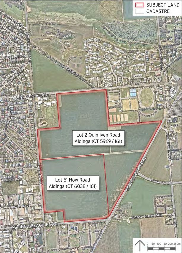
©Fyfe Pty Ltd, 2020
Proprietary Information Statement
The information contained in this document produced by Fyfe Pty Ltd is solely for the use of
the Client identified on the cover sheet for the purpose for which it has been prepared and
Fyfe Pty Ltd undertakes no duty to or accepts any responsibility to any third party who may
rely upon this document.
All rights reserved. No section or element of this document may be removed from this
document, reproduced, electronically stored or transmitted in any form without the written
permission of Fyfe Pty Ltd.
Document Information
Prepared by: Michael Osborn Planning Consultant, Fyfe Date: 14 November
Pty Ltd 2020
Reviewed by: Michael Osborn Planning Consultant, Fyfe Date: 14 November
Pty Ltd 2020
Approved by: Michael Osborn Planning Consultant, Fyfe Date: 20 November
Pty Ltd 2020
Client acceptance by: Stephen Senior Planner Date: 20 November,
Smith 2020
Revision History
Revision Revision Status Date Prepared Reviewed Approved
A Draft 16 July 2019 MO MO MO
B Draft 25 October 2020 MO MO MO
C Final 20 November MO MO MO
2020
Aldinga Deferred Urban Land Structure Plan 20/11/2020
page i
Contents 3.14 Activity Centres 36
3.15 Noise and Air Quality Assessment 37
1. INTRODUCTION 1
4. CONSULTATION 39
1.1 Structure Plan Study Area and Locality 1
4.1 Process 39
1.2 Role and Composition of the Structure Plan 3
4.2 Key Themes 39
2. STRATEGIC CONTEXT 4 4.3 City of Onkaparinga 40
2.1 State Strategies and Directions 4 5. STRUCTURE PLAN 41
2.2 Council Strategies 7
5.1 Overall Design Principles 41
2.3 City of Onkaparinga Development Plan 12
5.2 Dwelling Yield/Employment Lands Estimates 41
2.4 Planning and Design Code 16
5.3 Structure Plan Options 42
3. SITE ANALYSIS INVESTIGATIONS 17 5.4 Preferred Structure Plan - Key Structural Elements 44
3.1 Site Context 17 5.5 Infrastructure and Services 48
3.3 Site History 19 6. IMPLEMENTATION 50
3.4 Cultural Heritage 20
6.1 Staging 50
3.5 European Heritage 20
6.2 Development Plan Implications and Recommendations 50
3.6 Existing Zoning 21
3.7 Adjoining Land Uses 22 7. BIBLIOGRAPHY 51
3.8 Transport 24
3.9 Service Infrastructure Assessment and Stormwater 27
3.10 Visual and Landscape Assessment 31
3.11 Housing Assessment 32
3.12 Employment Lands Assessment 32
3.13 Social Impact Assessment 33
Aldinga Deferred Urban Land Structure Plan 20/11/2020
page ii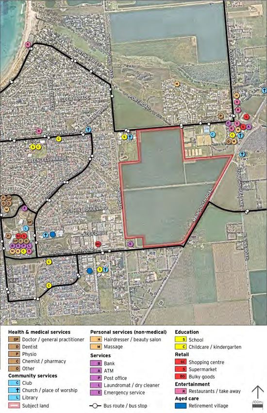
LIST OF TABLES Figure 5.1 Structure Plan Option 1 43
Figure 5.2 Structure Plan Option 2 43
Table 3-1 Detention Basin Volumes 31
Figure 5.3 Preferred Structure Plan 45
Table 3-2 Summary of Social Infrastructure Capacity Assessment 34
Figure 5.4 Recommended Intersection Upgrades 46
Table 5-1 Land Use Allocation 41
Table 5-2 Summary of Differences between Options 1 and 2 42
LIST OF FIGURES
Figure 1.1 Subject Land 1
Figure 1.2 Regional Context 2
Figure 1.3 Locality – Land Use Distribution 3
Figure 2.1 Concept Plan Map Onka/6 Development Sequencing 12
Figure 2.2 Location Map Onka/100 13
Figure 3.1 Regional Context 17
Figure 3.2 Topography 18
Figure 3.3 Existing Vegetation 19
Figure 3.4 Existing Zoning 21
Figure 3.5 Adjoining Land Uses 23
Figure 3.6 Transport Networks 24
Figure 3.7 Cycle Networks 25
Figure 3.8 Planned Intersection Upgrades 26
Figure 3.9 Existing Easements 28
Figure 3.10 Existing Potable Water and Sewer Infrastructure 28
Figure 3.11 Existing Electricity, Gas and Telecommunications
Infrastructure 30
Figure 3.12 Social Infrastructure 34
Figure 3.13 Open Space Catchment Analysis 36
Figure 3.14 Activity Centres 37
Figure 3.15 Evaluation Distances from EPA licensed facilities 38
Aldinga Deferred Urban Land Structure Plan 20/11/2020
page iii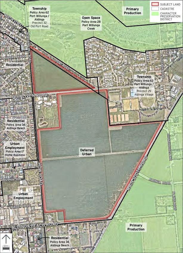
1. Introduction
1.1 Structure Plan Study Area and Locality
The Urban Renewal Authority, trading as Renewal SA, is the owner
of the following allotments:
• Lot 2 Quinliven Road, Aldinga (Certificate of Title Volume 5969
Folio 161);
• Lot 61 How Road, Aldinga (Certificate of Title Volume 6038
Folio 306).
The above allotments are shown in Figure 1.1 and are referred to
as the subject land throughout this document.
The subject land is situated to the north-west of the Main South
Road and Aldinga Beach Road and has an approximate area of
82.51 hectares.
The subject land is located some 40 kilometres to the south of the
Adelaide CBD, 1 kilometre to the east of the Aldinga District Centre
and 2.6 kilometres east of Aldinga Beach as shown on Figure 1.2.
Figure 1.1 Subject Land
Aldinga Deferred Urban Land Structure Plan 20/11/2020
page 1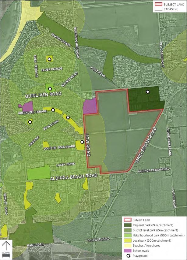
The subject land is presently vacant. Within the immediate locality
is the Aldinga Sports Park, which adjoins the north-eastern
boundary of the land. This facility features bowling, football and
dressage/equestrian facilities. It is proposed for significant
upgrade, with a master plan on consultation in late 2020. The
Cardijn College abuts the subject land to the north-west and the
Aldinga Beach CFS abuts the land to the south-west. The locality is
shown on Figure 1.3.
The subject land is mostly situated within the Deferred Urban Zone
and abuts the Deferred Urban and Township Zones to the north,
Residential Zone and Urban Employment Zones to the west and the
Primary Production Zone to the east. The Character Preservation
District also exists over the land to the east, securing the edge of
the urban boundary.
A parcel of land to the south of Aldinga Beach Road (Hart Road)
was rezoned to Residential in 2018.
Figure 1.2 Regional Context
Aldinga Deferred Urban Land Structure Plan 20/11/2020
page 2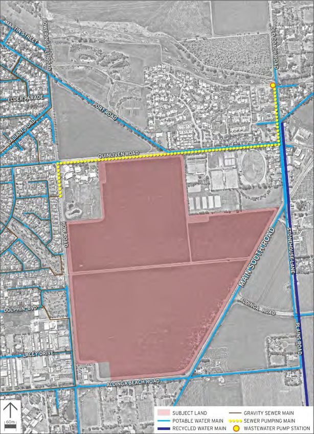
1.2 Role and Composition of the Structure Plan
The purpose of the Structure Plan is to guide the future rezoning
and development of the subject land. Key original required
outcomes of the Structure Plan included:
• reserving land for the future extension of the rail corridor from
Seaford to Aldinga, and identifying a location for a rail station
and park and ride;
• providing a site for a Birth to Year 12 school, noting in the
process of preparing this Plan, the site has been determined;
• addressing residential land supply in southern Adelaide.
Since the commencement of this Structure Plan process in 2018,
Renewal SA have been advised to assume that the rail corridor will
no longer need to extend through the subject land. It is to be
further assumed that any rail extension from Seaford will terminate
to the north of Quinliven Road.
The Structure Plan has been prepared in consultation with various
stakeholders including Renewal SA, the City of Onkaparinga, the
Department of Infrastructure and Transport (DIT) and the
Department for Education. In addition, a community engagement
process has been managed by Renewal SA, with several public
meetings convened to provide information on the Structure Plan
process and to obtain feedback as draft documentation has been
produced. The final Structure Plan has been informed by the
assumptions documented in this report, the
consultation/engagement process, together with detailed technical
Figure 1.3 Locality – Land Use Distribution
analysis and investigations, which are outlined in the following
chapters.
Aldinga Deferred Urban Land Structure Plan 20/11/2020
page 3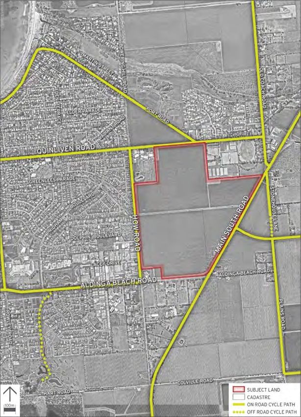
2. Strategic Context • Target 4 – Walkable Neighbourhoods: Increase the percentage
of residents living in walkable neighbourhoods in Inner, Middle
2.1 State Strategies and Directions and Outer Metropolitan Adelaide by 25% by 2045
2.1.1 30 Year Plan for Greater Adelaide (2017 Update) • Target 6 – Greater Housing Choice: Increase housing choice by
25% to meet changing household needs in Greater Adelaide by
The 30 Year Plan for Greater Adelaide sets out the policies, actions 2045
and targets to guide Adelaide towards becoming more liveable,
competitive and sustainable. The following Policy Themes and associated Policies are considered
relevant to the preparation of this Structure Plan.
The Plan identifies the Subject Land as within the planned urban
lands to 2045 (Map 3) and within Outer Metropolitan Adelaide Policy Theme Policy
(Figure 1.10 within the Plan). It also identifies the potential for a
Transit P1. Deliver a more compact urban form by locating
future fixed line (train or tram) to be extended to the site (Map 2). Corridors, the majority of Greater Adelaide’s urban growth
Similarly, this is reflected within the Council Development Plan growth areas within existing built-up areas by increasing density at
within Location Map Onka/100. and activity strategic locations close to public transport. (Map 2)
centres P2. Increase residential and mixed use development
The following targets are relevant to the preparation of this in the walking
Structure Plan: catchment of:
strategic activity centres*
• Target 1 - Containing our Urban Footprint and Protecting our appropriate transit corridors
Resources: 85% of all new housing in metropolitan Adelaide strategic railway stations.
will be built in established urban areas by 2045 P3. Increase average gross densities of development
within activity centres and transit corridor
• Target 2 – More ways to get around: 60% of all new housing in
catchments from 15 to 25 dwellings per hectare to
metropolitan Adelaide will be built within close proximity to 35 dwellings per hectare.
current and proposed fixed line (rail, tram, O-Bahn and bus) P5. Encourage medium rise development along key
and high frequency bus routes by 2045 transport corridors, within activity centres and in
urban renewal areas that support public transport
• Target 3 – Getting active: Increase the share of work trips use.
made by active transport modes by residents of Inner, Middle
and Outer Adelaide by 30% by 2045
Aldinga Deferred Urban Land Structure Plan 20/11/2020
page 4
Policy Theme Policy Policy Theme Policy
P7. Focus government services in higher-order safe cycling and pedestrian friendly streets that
activity centres that are well-serviced by public are tree-lined for comfort and amenity
transport to support viable clusters of activities and diverse areas of quality public open space
minimise car trips. (including local parks, community gardens and
playgrounds)
P8. Provide retail and other services outside
sporting and recreation facilities
designated activity centres where they will contribute
walkable connections to public transport and
to the principles of accessibility, a transit focused
community infrastructure.
and connected city, high quality urban design, and
economic growth and competitiveness. P49. Encourage more trees (including productive
P11. Ensure new urban fringe growth occurs only trees) and water sensitive urban landscaping in the
within designated urban areas and township private and public realm, reinforcing neighbourhood
boundaries and outside the Environment and Food character and creating cooler, shady and walkable
Production Areas, as shown on Map 3. neighbourhoods and access to nature.
Design Quality P27. Provide for transitions between higher density P50. Provide diverse areas of quality public open
and multi-storey, mixed-use developments in activity space in neighbourhoods (especially in higher density
centres, corridors and existing detached housing areas) such as local parks, community gardens,
precincts. playgrounds, greenways and sporting facilities to
encourage active lifestyles and support access to
P28. Promote permeable, safe, attractive, accessible nature within our urban environment.
and connected movement networks (streets, paths,
Transport P76. Improve the amenity and safety of public
trails and greenways) in new growth areas and infill
redevelopment areas that incorporate green transport stops, stations and interchanges by
infrastructure. improving their connections to adjacent development
and encouraging mixed-use development and
Housing Mix, P36. Increase housing supply near jobs, services and housing diversity in close proximity.
Affordability and public transport to improve affordability and provide
Competitiveness opportunities for people to reduce their transport P77. Ensure that new housing (and other sensitive
costs. land uses) permitted in locations adjacent to airports
and under flight paths or near major transport routes
Health, Wellbeing P47.Plan future suburbs and regenerate and renew (road, rail and tram) mitigates the impact of noise
and Inclusion existing ones to be healthy neighbourhoods that and air emissions.
include:
diverse housing options that support affordability
access to local shops, community services and
facilities
access to fresh food and a range of food services
Aldinga Deferred Urban Land Structure Plan 20/11/2020
page 5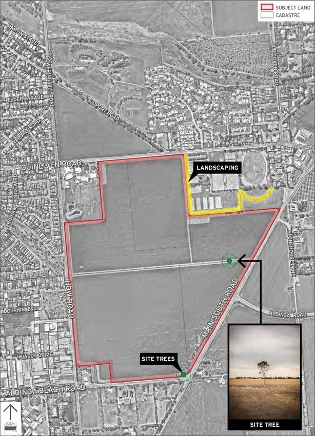
Policy Theme Policy
2.1.2 Integrated Transport and Land Use Plan
Infrastructure P83. Define and protect strategic infrastructure sites The Integrated Transport and Land Use Plan (ITLUP) sets out the
and corridors from inappropriate development to vision, solutions and actions for South Australia’s transport system
ensure the continued functionality of the services
into the future.
they provide.
Open Space, P99. Ensure quality open space is within walking The following solutions and actions identified for Outer Adelaide are
Sport and distance of all neighbourhoods to:
Recreation relevant to this Structure Plan:
link, integrate and protect biodiversity assets and
natural habitats 4. Define and preserve future train corridors to the north and
provide linkages to encourage walking and cycling
east of Gawler and from Seaford to Aldinga (identified for
to local activities, local activity centres and
regional centres the short to long term);
be multi-functional, multiuse (including the
9. Main South Road duplication (envisaged for the long term or
shared use of strategically located school
facilities) and able to accommodate changing use 15+ years);
over time
incorporate the principles of Crime Prevention
27.Seaford, Aldinga. McLaren Vale and Willunga, shoulder
Through Environmental Design for safety and sealing to improve conditions for cyclists (identified for the
amenity medium to long term);
contain appropriate and low maintenance species
and locate trees to maximise shade Improve walking and cycling facilities in catchment areas for
encourage unstructured recreation opportunities schools, public transport stations, activity centres and main
such as the provision of a variety of paths and streets;
children’s play equipment
foster a connection to the natural environment Work with local councils and the Local Government Association
through the provision of nature play spaces and to implement local transport strategies to complement land use
urban forest opportunities.
directions of local Development Plans, with a focus on
Water P115. Incorporate water-sensitive urban design in accessible neighbourhoods, integration with public transport,
new developments to manage water quality, water
quantity and water use efficiency and to support cycling and walking networks and state freight/major traffic
public stormwater systems. networks.
Aldinga Deferred Urban Land Structure Plan 20/11/2020
page 62.2 Council Strategies Theme Desired Outcome
2.2.1 City of Onkaparinga Community Plan 2035 Our suburbs and neighbourhoods, our hills,
spectacular coast and townships are great places to
live – places we are proud of and feel at home in.
The Onkaparinga 2035 Plan builds on the previous Community Plan
2035 and guides Council’s decisions about services, assets and Our neighbourhoods offer an engaging and diverse
lifestyle, including a range of affordable and varied
projects with a vision to create strong vibrant communities. To do housing choices, local employment and easily
so, the Plan identifies three themes being People, Place and accessed recreation and entertainment opportunities.
Prosperity. We are a green city where sustainable residential
development is common-place and our streets are
Each theme has three objectives and outlines the desired cool, green, pleasant places that sustainably manage
outcomes. The desired outcomes most relevant to this Structure stormwater.
Plan are outlined below: Multi-generational living is supported in our housing
areas, comprising both our established areas and new
areas, where diverse living opportunities are provided
Theme Desired Outcome close to good public transport, quality open space and
People People here lead healthy and active lifestyles with local services.
access to high quality locally produced food, open Prosperity The city’s water is harvested from sustainable sources
space and recreational opportunities. and a large percentage of our energy comes from
Both passive and active recreation (including sport and renewable sources.
opportunities to connect with nature) are an
embedded part of life. 2.2.2 City of Onkaparinga Land Use Strategy 2014-19
Place Our integrated network of regional, district and
smaller centres are active hubs for gathering, The Land Use Strategy (now superseded but relevant at the time
shopping, business, health and community services, the Structure Plan process was commenced) guides amendments to
entertainment, living and education activities. the Council’s Development Plan anticipated between 2014 and 2019
Our centres are welcoming, friendly and can be open and summarises the outcomes of the Council’s Strategic Directions
for business day or night and feel safe to everyone. Report required under section 30 of the Development Act 1993.
There is good integration between our recreational,
commuter and business transport networks. The Strategy anticipates the following in relation to the subject
The future rail link to Aldinga (and beyond) supports land:
sustainable urban housing growth and
efficient/equitable transport opportunities.
Aldinga Deferred Urban Land Structure Plan 20/11/2020
page 7‘Rezone Deferred Urban land to residential after master 2.2.4 City of Onkaparinga Healthy Active Lifestyles
planning has been undertaken by the state government and Strategy 2014-19
location of future railway corridor and station has been
decided.’ The Healthy Active Lifestyles Strategy 2014-19 (now superseded
but relevant at the time the Structure Plan process was
This Structure Plan responds to this strategic direction within the commenced) provides the framework for how Council will plan for
Land Use Strategy. recreational and sporting opportunities and capacity within our
communities.
2.2.3 City of Onkaparinga Environment Strategy 2014-19
It seeks to promote participation and use of facilities that contribute
The Environment Strategy (now superseded but relevant at the to health in the region by identifying the strategic actions from the
time the Structure Plan process was commenced) outlines the Community Plan 2035 and from individual Strategic Management
policy approach and role of the Council in planning for Plans.
environmental sustainability. The following strategic directions
highlighted within the Strategy are most relevant to this Structure The following strategic actions are considered relevant to the
Plan: preparation of this Structure Plan:
• Maximise the efficient use and reuse of all our water resources; • Provide active recreation infrastructure
• Protect and restore local biodiversity and integrate natural • Plan, develop and manage sports grounds and facilities (noting
spaces into our urban areas; intentions to upgrade Aldinga Sports Park adjacent the site)
• Integrate environmental sustainability considerations into land • Develop a network of diverse, quality recreational trail and
use planning and urban development including the application shared use path experiences in the City of Onkaparinga
of sustainability guidelines, assessment tools and criteria; • Develop a network of diverse and quality recreation open space
• Promote water sensitive urban design in developments at a at City, suburb and township level that provides equitably for
catchment and regional level; community needs now, and in the future.
• Promote the planting of street trees in the urban landscape;
• Factor climate change considerations into the design of our
city’s infrastructure and built assets and the management of
our natural assets.
Aldinga Deferred Urban Land Structure Plan 20/11/2020
page 82.2.5 Aldinga Framework Plan (2019) Theme Opportunities and Issues
The Aldinga Framework Plan (AFP) has been prepared by the City Landscape buffers to Main South Road and Port
of Onkaparinga to provide input into the Structure Plan by Road
consolidating known information about the Aldinga region including Centrally located open space with connections to
Council’s strategies, asset management plans and known Village and Sports Park
opportunities and issues raised by the community. Higher density development located centrally
Transport and Impact of Main South Road duplication on land
The AFP is presented under the following four themes: Movement Opportunity for shared use path within rail
corridor
• Planning and Development;
Road crossing middle of subject land and rail
• Movement and Transport; corridor, connecting to Aldinga Road
• Landscape, Open Space and Water;
Road access to the east of the corridor from
• Tourism and Economy. Quinliven Road
Recommend 600-1000 car capacity Park and
The following opportunities and issues identified within the AFP that Ride facility to the west of corridor
are most relevant to the preparation of the Structure Plan are Road/pedestrian link adjacent Aldinga Sports
outlined below: Park
Pedestrian link to Aldinga Village
Theme Opportunities and Issues Upgrade How Road and Quinliven/How Road
intersection
Planning and Sport/recreation facilities to be relocated west of
Development rail corridor, north of Quinliven Road Strengthen/support pedestrian/cycle links to the
west of the land
Open space positioned east of rail corridor north
of Quinliven Road Landscape, Open Opportunity to use railway corridor as linear park
Space and Water Linear east/west park connecting Aldinga Village
Extension of Urban Employment Zone
and pedestrian link to the west
Pedestrian/cycle links within high voltage power
easement Integrate stormwater run-off within open space
Opportunity for walkable proximity to Aldinga Opportunity for neighbourhood level ‘family’ park
Village for future station Landscape buffer to Main South Road for visual
Achieve a sense of arrival for Port Willunga by buffer and acoustic separation
maintaining the open/rural character
Aldinga Deferred Urban Land Structure Plan 20/11/2020
page 9Theme Opportunities and Issues
Of particular note, the SARMP has identified that the southern
portion of the City of Onkaparinga, including Aldinga, will
Retain land to the north of Quinliven Road and experience a shortage of sporting and recreation facilities as
east of rail corridor for open space
development of this area continues. In the context of the site,
Movement of water between subject land and
Aldinga Sports Complex abuts the north-eastern corner of the land
How Road wetland/detention ponds is critical
and contains equestrian, bowling and football facilities. The Plan
Stormwater basin required on subject land
identifies the following direction for this complex:
Northern portion of site to drain to Quinliven
Road (if pre-development flows can be ‘Implement the master plan for the sports ground and place
demonstrated)
a focus on integrating and improving the quality of facilities
Tourism and Development should not include further
Economy retail/commercial land uses that may weaken
(including achieving quality multi-use facilities).’
existing centres
With regard to the above, the following actions are considered
Expand Urban Employment Zone as zones are at
relevant to the preparation of this Structure Plan:
capacity in Willunga and McLaren Vale (whilst
considering stormwater management needs)
Aim Action
As a number of opportunities and issues within the AFP relate to
Community Action 1.8 Design environments to support physical
areas external to the subject land or to final design of the future Participation activity and community health, drawing on national
school or development. Whilst these matters are acknowledged, design principles (Heart Foundation Healthy By
they are outside the scope of the Structure Plan, which is a high- Design, CPTED) and placing a focus on walkable, safe
and appealing neighbourhoods.
level concept plan to guide future development of the subject land.
Sports Action 3.4 Plan for new sports grounds in the southern
2.2.6 City of Onkaparinga Sport and Active Recreation Infrastructure part of the City of Onkaparinga to meet future
population growth.
Management Plan 2014-19
Action 3.7 Improve the provision and quality of
The Sport and Active Recreation Management Plan (SARMP) 2014- outdoor sports courts including the planning for
strategically located regional and district level tennis
19 guides the provision and management of recreation and sporting
facilities (north, central and south), to address
facilities and is set out under four aims being Community potential future gaps in provision.
Participation, Sport and Club Development Services, Sports
Infrastructure and Active Recreation Facilities.
Aldinga Deferred Urban Land Structure Plan 20/11/2020
page 10Aim Action
The following planning principles within the OSSMP are relevant to
this Structure Plan:
Action 3.12 Subject to the findings of current Horse SA
strategic planning and in consultation with equestrian • Open Space Provision Levels: Our total open space provision is
groups, consolidate equestrian facilities and plan for
to be between 4-5 hectares per 1000 head of population;
higher quality facilities at key locations in the City of
Onkaparinga. • The role of non-council owned open space: The city is well
Active Action 4.3 Enhance the quality, connection and provided for in relation to beaches, national parks, school ovals
Recreation diversity of trails, pathways and footpaths across our and other non-council owned spaces. The access to these
Facilities region in accordance with the revised Recreation Trails spaces will be accounted for as part of Council’s open space
Network Strategy and Action Plan.
network;
• New Developments and Land Divisions: Land divisions should
At the time of finalising this Structure Plan, the SARMP was under
provide quality land for community open space purposes (i.e.
review.
flat/undulating, large trees, views, well drained, natural
In July 2020, Council announced a $4.6m upgrade of the Aldinga beauty).
Sports Park. This upgrade, together with an agreement to access Where possible, open space should be located centrally within
the sporting fields provided within the adjacent B-12 school has a development or catchment and not on extremities or
provided the opportunity to integrate facilities and to create a peripheral areas;
sports and community hub for the broader southern region. A • Play Spaces: One play space (consisting of built playgrounds
master plan has been prepared and was subject to stakeholder and nature play or a combination) should be provided as one
engagement in late 2020. per every 1200 people.
2.2.7 City of Onkaparinga Open Space Strategy 2018 - 2.2.8 Onkaparinga Local Area Plan - 2020
2023
The City of Onkaparinga, State Planning Commission and Renewal
SA have partnered to develop a Local Area Plan (LAP) to guide
The Open Space Strategic Management Plan (OSSMP) sets the
growth at Onkaparinga over the next 20 years. The LAP adopted 12
principles, planning and direction for future provision, development
strategies which were organised into 4 themes. Rezoning
and maintenance of the open space network.
investigations in respect to Aldinga is consistent with one of the key
Further, the OSSMP sets out the Open Space Hierarchy, planning recommended actions contained within the LAP.
principles and establishes recommended provision levels to inform
planners, asset planners and landscape architects.
Aldinga Deferred Urban Land Structure Plan 20/11/2020
page 112.3 City of Onkaparinga Development Plan The future railway corridor is also highlighted on Location Map
Onka/100 shown in Figure 2.2 below.
At the time of preparing this Structure Plan, the City of Onkaparinga
Development Plan, dated 20 October 2020 was the relevant
planning instrument.
Whilst the development of land within the City of Onkaparinga is
assessed against the provisions of this Development Plan, it is likely
that the future development of this site will be assessed against the
Planning and Design Code (the Code).
The Code will be operational by early 2021 and will be the tool used
for assessing the future development of the land, including land
division and subsequent dwellings.
Notwithstanding this, it is expected that a number of the general
provisions within the Development Plan will be transitioned in a
similar form into the new PDC and are considered relevant to this
Structure Plan.
The land is mostly situated within the Deferred Urban Zone
identified by Zone Map Onka/100. The Deferred Urban Zone
generally envisages farming and agricultural activities that will not
prejudice the future development of the land for residential
purposes. Of particular note, it outlines the sequencing of rezoning
of land for residential purposes to ensure that undue pressure is
not placed on existing infrastructure. This sequencing is shown in
Concept Plan Onka/6 as shown in Figure 2.1.
This Structure Plan will inform the rezoning of the land with a
Ministerial DPA initiated for this purpose. Figure 2.1 Concept Plan Map Onka/6 Development Sequencing
Aldinga Deferred Urban Land Structure Plan 20/11/2020
page 12The General or ‘Council wide’ policies within the Development Plan
are relevant to the Structure Plan, particularly in relation to
interface between land uses, open space, transport and access and
stormwater management.
The following Principles of Development Control (PDCs) are
considered relevant to managing the interface between land uses:
4 Residential development adjacent to non-residential
zones and land uses should be located, designed
and/or sited to protect residents from potential
adverse impacts from non-residential activities.
15 Existing primary production and mineral extraction
should not be prejudiced by the inappropriate
encroachment of sensitive uses such as urban
development.
16 Development that is adjacent to land used for
primary production (within either the zone or
adjacent zones) should include appropriate setbacks
and vegetative plantings designed to minimise the
potential impacts of chemical spray drift and other
impacts associated with primary production.
17 New urban development should allow for a buffer of
at least 40 metres wide (inclusive of any fuel break,
emergency vehicle access or road) separating urban
and rural activities.
Figure 2.2 Location Map Onka/100
Aldinga Deferred Urban Land Structure Plan 20/11/2020
page 13The following PDCs relating to the provision of Open Space are 3 Transport corridors should be sited and designed so
considered relevant to this Structure Plan: as to not unreasonably interfere with the health and
amenity of adjacent sensitive land uses.
5 District level parks should be at least 3 hectares in
size and provided within 2 kilometres of all 4 Roads should be sited and designed to blend with
households that they serve. the landscape and be in sympathy with the terrain.
6 Neighbourhood parks should be at least 0.5 hectares 5 Land uses that generate large numbers of visitors
and generally closer to 1 hectare in size and such as shopping centres, places of employment,
provided within 500 metres of households that they schools, hospitals and medium to high density
serve. residential uses should be located so that they can
7 Local parks should be: be serviced by the public transport network and
encourage walking and cycling.
a) a minimum of 0.2 hectares in size
b) centrally located within a residential area, close 6 Development generating high levels of traffic, such
to schools, shops and generally within 300 as schools, shopping centres and other retail areas,
metres of households that they serve. and entertainment and sporting facilities should
incorporate passenger pick-up and set-down areas.
8 No more than 20 per cent of land allocated as public
The design of such areas should minimise
open space should:
interference to existing traffic and give priority to
a) have a slope in excess of 1-in-4 pedestrians, cyclists and public and community
b) comprise creeks or other drainage areas. transport users.
The following PDCs relating to the provision of Transportation and
12 Development should be designed to discourage
Access are considered relevant to this Structure Plan:
commercial and industrial vehicle movements
2 Development should be integrated with existing through residential streets and adjacent other
transport networks, particularly major rail, road and sensitive land uses.
public transport corridors as shown on Location Maps
16 Development should provide access, and
and Overlay Maps - Transport and designed to
accommodate multiple route options, for pedestrians
minimise its potential impact on the functional
and cyclists by enhancing and integrating with:
performance of the transport network.
Aldinga Deferred Urban Land Structure Plan 20/11/2020
page 14a) open space networks, recreational trails, parks, 11 Development should include stormwater
reserves, and sport and recreation areas management systems to mitigate peak flows and
b) Adelaide’s principal cycling network (Bikedirect), manage the rate and duration of stormwater
which includes arterial roads, local roads and off- discharges from the site to ensure the carrying
road paths as depicted in Overlay Maps - capacities of downstream systems are not
Transport. overloaded.
17 New developments should give priority to and not 14 Stormwater management systems should:
compromise existing designated bicycle routes.
a) maximise the potential for stormwater
The following PDCs relating to the provision of Stormwater harvesting and re-use, either on-site or as close
Management are contained within the Natural Resources section of as practicable to the source
the Development Plan considered relevant to this Structure Plan: b) utilise, but not be limited to, one or more of the
following harvesting methods:
5 Development should be designed to maximise
i. the collection of roof water in tanks
conservation, minimise consumption and encourage
ii. the discharge to open space, landscaping or
re-use of water resources.
garden areas, including strips adjacent to car
9 Development should include stormwater parks
management systems to protect it from damage iii. the incorporation of detention and retention
during a minimum of a 1-in-100year average return facilities
interval flood. iv. aquifer recharge.
10 Development should have adequate provision to
17 Development located within any of the following
control any stormwater over-flow runoff from the
areas should not adversely affect the quality or
site and should be sited and designed to improve the
quantity of water resources:
quality of stormwater and minimise pollutant transfer
to receiving waters. a) ‘River Murray Protection Area - Tributaries Area’
designated on Concept Plan Map Onka/1 -
Development Constraints - Water Management
Areas
Aldinga Deferred Urban Land Structure Plan 20/11/2020
page 15b) ‘Prescribed Wells Areas’ designated on Concept 2.4 Planning and Design Code
Plan Map Onka/1 - Development Constraints -
Water Management Areas South Australia’s planning system is transitioning to the Planning,
c) ‘Mount Lofty Watershed 1’ designated on Development and Infrastructure Act 2016 (the PDI Act), which is
Concept Plan Map Onka/2 - Development replacing the Development Act 1993 in stages. The PDI Act sets
Constraints Mount Loft Ranges Water out a new way in which development applications and development
Management Areas policy will be assessed and monitored across the state.
d) ‘Prescribed Water Resource Areas’ designated on The Code has already been implemented over the outback areas
Concept Plan Map Onka/2 - Development (Phase 1) and regional areas (Phase 2). Phase 3 of the Code,
Constraints Mount Lofty Ranges Water which covers greater metropolitan Adelaide, will be implemented as
Management Areas. the final phase.
Of note, the subject land is identified with the McLaren Vale It is noted that the draft Planning and Design Code, which was
Prescribed Wells Area on Concept Plan Map Onka/1 - Development placed on consultation in October 2019, and again in November
Constraints - Water Management Areas and within the Western 2020, sought to retain the Deferred Urban zoning over the land. A
Mount Lofty Ranges Prescribed Water Resources Area on Concept recently rezoned parcel of land, located at Hart Road, is proposed
Plan Map Onka/2 - Development Constraints Mount Lofty Ranges to be located within a Master Planned Neighbourhood Zone.
Water Management Areas.
Notwithstanding this, the subject land is not within a Prescribed
Surface Water Area and therefore, the construction of a stormwater
detention basin is unlikely to be impacted by the above.
Council’s Development Plan also details future road widening
distances in Table Onka/2 – Building Setbacks from Road
Boundaries.
These road widening requirements will require further consultation
with Council and DIT, as discussed in Chapter 3.
Aldinga Deferred Urban Land Structure Plan 20/11/2020
page 163. Site Analysis Investigations
3.1 Site Context
The subject land comprises the following allotments:
• Lot 2 Quinliven Road, Aldinga (Certificate of Title Volume 5969
Folio 161) which is bound by Main South Road to the east, Lot
61 to the south, How Road to the west and Quinliven Road to
the north; and
• Lot 61 How Road, Aldinga (Certificate of Title Volume 6038
Folio 306) abuts Lot 2 to the north and east, Aldinga Beach
Road to the south and How Road to the west.
The subject land is approximately 1 kilometre to the west of the
Aldinga District Centre, 14 kilometres from the Noarlunga Regional
Centre and approximately 40 kilometres from the Adelaide CBD as
shown in Figure 3.1. The subject land is also only 2 kilometres east
of the coast.
The subject land generally falls from the north-east to the south-
west. The topography of the subject land is shown in Figure 3.2.
Figure 3.1 Regional Context
Aldinga Deferred Urban Land Structure Plan 20/11/2020
page 173.2 Existing Vegetation and Ecology
On the instruction of Renewal SA, Peter Oates (Arborman Solutions
Pty Ltd) inspected the site on 14 September 2018 and prepared a
Preliminary Tree Assessment1.
The subject land is presently used for broad acre cropping and is
effectively void of structures and any vegetation. By virtue of this,
the land does not feature native vegetation or habitat.
Only 1 tree exists on the site which has been identified as a
regulated tree for the purposes of the Development Act 1993.
Vegetation does also exist adjacent to the intersection of Aldinga
Beach Road and Main South Road.
The location of vegetation is shown on Figure 3.3.
Figure 3.2 Topography
1
Copy of report available at: https://renewalsa.sa.gov.au/projects/aldinga-
structure-plan/
Aldinga Deferred Urban Land Structure Plan 20/11/2020
page 183.3 Site History
At the request of Renewal SA a preliminary site investigation has
been undertaken by Agon Environmental Pty Ltd (Agon) in
accordance with the guidance provided within Schedule B2 of the
National Environment Protection Council (1999) National
Environment Protection (Assessment of Site Contamination)
Measure, as amended in 2013 (the NEPM).
The investigation confirmed that the subject land had been used for
agricultural purposes since the early 1900’s and continued to be
used for dryland cropping when it was purchased by the South
Australian Urban Land Trust, Land Management Corporation and
then then transferred to the Urban Renewal Authority.
Agon identified the following potentially contaminating activities
(PCAs) resulting from historical and current land uses of the subject
land:
• Historical application of pesticides / herbicides;
• Site Operations (Agricultural purposes); and
• Migration of contaminants from neighbouring properties.
Based on site history information and an analysis of the potential
significance of these activities, Agon concluded that any
contamination impacts present on the subject land associated with
these PCAs are likely to be highly localised and that ‘the risk to
human health and the environment from potential site
contamination at the site is considered to be low’.
Figure 3.3 Existing Vegetation
Aldinga Deferred Urban Land Structure Plan 20/11/2020
page 19Since the preparation of the Agon report, portion of the site is in A survey was completed in two phases – firstly, an anthropological
the process of being developed to accommodate the R-12 public assessment that was followed by a surface archaeological survey
school. This school is located in the north-eastern corner of the several months later owing to site conditions.
subject land. The Structure Plan will seek to ensure development
integrates with the school land. The background research shows several archaeological sites,
objects and remains have been previously recorded within the
3.4 Cultural Heritage general region, which provide contextual archaeological information
that demonstrates a culturally rich and diverse environment
The Aboriginal Affairs and Reconciliation Branch of the Department encompassing the general region, middle and southern Fleurieu
of State Development has undertaken a search of the Register of Peninsula.
Aboriginal Sites and Objects and confirmed that no Aboriginal sites
have been recorded within the project area to date. The site anthropological assessment found no anthropological sites
exist. The archaeological survey found some isolated remnant
Should sites or objects be discovered during the development of artefacts in a heavily disturbed environment, with relevant areas of
the site, these are protected by the Aboriginal Heritage Act 1988. likely cultural sensitivity mapped and recorded.
The discovery of sites and objects must also be reported to the
Minister for Aboriginal Affairs and Reconciliation. Based on the results of the Aboriginal cultural heritage survey
several recommendations have been made. Discussions with
It is relevant to note that the subject land has been impacted by KNCHA will continue to ensure appropriate collaborative
pastoral activity since the early 1900’s and no findings have been management of the site’s heritage values.
recorded on the Register during this time.
3.5 European Heritage
During engagement on the Draft Aldinga Structure Plan, members
of the local Kaurna community attended one of the drop-in No heritage listed places exist on the subject land.
sessions, from which ongoing discussions have been established.
Local and State Heritage Places however do exist within the
A key outcome has been the engagement of Integrated Heritage immediate locality, particularly to the north-east of the subject land.
Services (IHS) by Renewal SA to undertake an Aboriginal cultural Of note is the Local Heritage Memorial Avenue of Pine Trees along
heritage. IHS engaged Kaurna Nations Cultural Heritage Association Port Road. Many of the Local Heritage Places to the north east
(KNCHA) traditional owner representatives to provide cultural comprise local shops, former butcher and post office, the church,
knowledge, expertise and services. cemetery, Aldinga Institute and various dwellings.
Aldinga Deferred Urban Land Structure Plan 20/11/2020
page 20The two State Heritage Places are east of Old Coach Road and are
the former Temperance Hotel and the Memorial to the Wreck of the
Star of Greece.
Further to the north-west, is a Local Heritage Former Farmhouse.
The existence of these Heritage Places should not directly constrain
the future development of the land.
The visual contribution of this European Heritage is considered
within the Visual Character Assessment prepared by Wax which is
discussed in Chapter 3.11.
3.6 Existing Zoning
The subject land is primarily situated within the Deferred Urban
Zone, which seeks to maintain the primary production use of the
land without prejudicing the conversion of the land for residential
purposes at a later date. Portion of the subject land is located
within the Township Zone (north-eastern corner which forms
portion of the new B-12 school). The zoning of the subject land and
locality is shown in Figure 3.4.
The subject land abuts several different zones. These are detailed
below:
• The Primary Production Zone to the east and south of the
subject land, across Main South Road;
• Urban Employment Zone and Residential Zone to the west of
the land, noting that a large portion of the Urban Employment
Zone is actually in a Home Business Policy Area;
Figure 3.4 Existing Zoning
• Deferred Urban Zone to the north of the subject land;
Aldinga Deferred Urban Land Structure Plan 20/11/2020
page 21• Township Zone to the north of the land, including the Aldinga • Aldinga Sports Park including dressage, football, tennis and
Sports Park and Port Road (This Zone is also affected by lawn bowls facilities;
Policy Area 62 Port and Precinct Area 29 Aldinga Village); and • Coach Road Child Care centre;
• The Open Space Zone exists to the north of the Township • The Aldinga Arts Eco Village which comprises residential
Zone. dwellings.
The land within the Open Space Zone and land to the south-east To the west of the subject land, the following land uses exist:
are also within the Character Preservation District.
• Cardijn College and Catholic Community Hall;
Future development of the subject land will need to manage the • Residential, primarily in the form of detached dwellings on
interface with the adjoining zones, particularly with those less allotments ranging from 400 to 800 square metres in size;
compatible with the intended residential use of the subject land. • Various industrial and bulk goods sales outlets, such as Aldinga
Custom Woodworks, motor repair stations, crash repairers and
Additional/more detailed mechanisms to manage the interface will the Aldinga Recycling Centre;
need to be further considered as part of the future rezoning of the
• Electricity substation.
subject land.
It is noted that the draft Planning and Design Code, which was To the south of the subject land, the following land uses exist:
placed on consultation in October 2019, and again in November • Aldinga Beach CFS Station;
2020, sought to retain the Deferred Urban zoning (albeit within the • Detached dwellings on large allotments (approximately 2
new Code format).
hectares) (within the Primary Production Zone).
3.7 Adjoining Land Uses
To the east of the subject land, the predominant land use is
Given the number of different zones that abuts the subject land, it horticulture in the form of vineyards with associated detached
is not unexpected that a number of non-residential uses are also dwellings.
evident adjacent the subject land. These are shown in Figure 3.5
and described below:
To the north of the subject land, the following land uses exist:
Aldinga Deferred Urban Land Structure Plan 20/11/2020
page 22Figure 3.5 Adjoining Land Uses
Aldinga Deferred Urban Land Structure Plan 20/11/2020
page 233.8 Transport
An overview of transport corridors in proximity to the subject land
are shown within Figure 3.6 and described further under the
relevant heading below. A Transport Assessment Report2, prepared
by traffic consultants MFY.
3.8.1 Road Networks
As shown in Figure 3.6, an Arterial Road (Main South Road) forms
the south-eastern boundary of the subject land. Distributor roads
abut the southern and northern boundaries of the subject land
(Aldinga Beach Road Quinliven Road respectively). Access to Main
South Road is via these distributor roads. A distributor road (How
Road) also extends along the western boundary of the subject land.
3.8.2 Public Transport – Bus and Future Train
Bus stops adjacent to the subject land include:
• Stop 113 on Aldinga Beach Road;
• Stops 102 and 105 on Quinliven Road;
• Stop 106 on Bowering Hill Road.
Bus services operating via these stops include 750, 751, 755 and
756. These services operate between Aldinga Central Shopping
Centre and the Colonnades Shopping Centre. The location of bus
stops and routes is shown on Figure 3.6.
Figure 3.6 Transport Networks
2
Copy of report available at: https://renewalsa.sa.gov.au/projects/aldinga-
structure-plan/
Aldinga Deferred Urban Land Structure Plan 20/11/2020
page 24The 30 Year Plan for Greater Adelaide, the Integrated Transport
and Land Use Plan and City of Onkaparinga Development Plan
anticipate the extension of the Seaford Rail Corridor south to
Aldinga and through the subject land. A 100metre wide corridor to
accommodate this extends from the north and terminates at
Aldinga Beach Road.
3.8.3 Bicycle Network
Figure 3.7 identifies the existing bike network in the locality. The
bicycle network in the immediate vicinity of the subject land is in
the form of on road cycle paths along both Quinliven Road and
Main South Road.
Figure 3.7 Cycle Networks
Aldinga Deferred Urban Land Structure Plan 20/11/2020
page 253.8.4 Planned Intersection and Road Infrastructure
Upgrades
DIT has been undertaking transport planning investigations of the
area with key strategic decisions including:
• the provision of a 17m wide road widening requirement to
support the duplication of Main South Road;
• road widening at the intersection of Main South Road and
Aldinga Beach Road to accommodate a future intersection
upgrade;
• the provision of roundabouts (2) on Quinliven Road in support
of the B-12 school;
• the planned upgrade of the intersection of Aldinga Road and
Main South Road.
Planned intersection upgrades are shown on Figure 3.8. Whilst not
shown on this figure, it is understood that Council is anticipating
the need to upgrade the intersection of Aldinga Beach Road and
How Road, noting investigations which were undertaken to support
the rezoning of the Hart Road land to the south.
Figure 3.8 Planned Intersection Upgrades
Aldinga Deferred Urban Land Structure Plan 20/11/2020
page 263.9 Service Infrastructure Assessment and Stormwater 3.9.1 Easements
A Service Infrastructure Assessment4 was undertaken by Fyfe. This Figure 3.9 shows the easement registered on the Certificates of
assessment was to: Title for the subject land. This comprises an electricity easement
traversing Lot 2 Quinliven Road and Lot 61 How Road, in an east-
• Assess the existing infrastructure availability and capacity with west alignment between Main South Road and How Road.
regard to the future development of the subject land;
• To attain an appreciation of the required upgrade or 3.9.2 Existing Potable Water Infrastructure
augmentation works that may be associated with the
development of the subject land. SA Water has existing potable water mains in all adjacent roads
except Quinliven Road and the northern portion of How Road. The
In addition, the following service authorities were consulted as part details of the existing mains are as follows:
of the assessment, including: • Port Road – 200mm Asbestos Cement main;
• SA Water (for potable water, recycled water and sewer); • Main South Road – 80mm Cast Iron main;
• SA Power Networks (for electricity); • Aldinga Beach Road – 500mm Ductile Iron Concrete Lined
• APA Group (for gas reticulation); main;
• National Broadband Network (NBN) (for telecommunications). • How Road – 150mm Asbestos Cement main;
• Bowering Hill Road – 150mm Asbestos Cement main.
A potential yield of 1,000 dwellings was assumed for the
infrastructure assessment, notwithstanding such could be exceeded Existing potable water infrastructure is shown in Figure 3.9.
if ultimate dwelling densities are higher than anticipated. The
findings of the investigations have confirmed that the future
development of the subject land will not be constrained by the
availability of infrastructure.
The existing infrastructure and required works are described under
each of the subheadings below.
Aldinga Deferred Urban Land Structure Plan 20/11/2020
page 27Figure 3.9 Existing Easements Figure 3.10 Existing Potable Water and Sewer Infrastructure
Aldinga Deferred Urban Land Structure Plan 20/11/2020
page 28Based on the advice provided by SA Water, the following Existing sewer infrastructure is shown within Figure 3.10 above.
headworks will be required:
In order to facilitate the development of the subject land, capital
• Construction of approximately 320m of DN450 potable water works and headworks will be required. Capital works will include a
main within Aldinga Road; pump station upgrade, flow monitoring and a pumping main
• Construction of approximately 560m of DN250 potable water redirection. Headworks will consist of an extension of an existing
main within Quinliven Road; gravity sewer main.
• Abandon approximately 1000m of DN80 potable water main
within Main South Road. 3.9.5 Existing Electricity Infrastructure
There are existing high voltage (11kV) cables on all roads adjacent
3.9.3 Existing Recycled Water Infrastructure the subject land, except for Main South Road and Port Road.
SA Water has two existing recycled water pipelines (375mm) that In addition, there are two high voltage (66kV) cables that cross the
run north-south adjacent the subject land. Existing recycled water subject land itself and include existing easements (nominally 17.6m
infrastructure is shown in Figure 3.10. to 26 metres) in favour of SA Power Networks. These cables run
The recycled water network in this area has available capacity to between Main South Road and How Road, and Bowering Hill Road
supply the new school and the residential development via a and Port Road.
connection adjacent the Main South Road and Old Coach Road Existing electrical infrastructure is shown in Figure 3.11.
intersection adjacent the eastern boundary of the subject land.
It is expected that there will be some external works (i.e. alteration
3.9.4 Existing Sewer Infrastructure to stobie pole arrangements) required to service the subject land.
SA Water has an existing gravity and rising mains within the roads This will be determined once final layout, composition and staging
adjacent the subject land. The details of the existing infrastructure of any future development is known.
are as follows: Based on advice from SA Power Networks, the augmentation
• Port Road/Quinliven Road – 100mm PE rising main and 225mm charge will cover any headworks that are required. The
PVC gravity main (eastern side only); augmentation charge will be borne by the eventual developer or
• Aldinga Beach Road – 225mm PVC gravity main; developers of the subject land.
• How Road – 300mm PVC gravity main;
• Bowering Hill Road – 150mm PVC gravity main.
Aldinga Deferred Urban Land Structure Plan 20/11/2020
page 293.9.6 Existing Gas Infrastructure
The APA Group has high pressure gas mains located within
Quinliven Road and How Road as follows:
• Quinliven Road – 100SP main;
• How Road – 110PMT main from Quinliven Road and 110PMT
main between Bluepoint Way and Dolphin Boulevard.
Existing gas infrastructure is shown on Figure 3.11 above.
APA have confirmed that they can supply gas to the future
development on the subject land. It is possible that there will be
some external works (i.e. extension from the existing gas mains)
required to service the subject land. This will be determined once
final layout, composition and staging of the future development is
known.
3.9.7 Existing Telecommunications Infrastructure
Telecommunications infrastructure exists in Quinliven Road, How
Road, Aldinga Beach Road and Old Coach Road. Existing
telecommunications infrastructure is shown in Figure 3.11 above.
NBN co will be able to provide telecommunication services to the
site and there will be a per premise deployment contribution
required. This is currently $400 for a multi dwelling unit (MDU) and
$600 for a single dwelling unit (SDU).
Figure 3.11 Existing Electricity, Gas and Telecommunications
Infrastructure
Aldinga Deferred Urban Land Structure Plan 20/11/2020
page 303.9.8 Stormwater
A number of options exist to manage stormwater arising from the Other alternatives exist, such as a sequential chain of ponds
future development of the subject land, having regard to the approach, which is preferred approach of the Council.
existing infrastructure and capacity restraints evident to the south
and east of the subject land. The exercise has demonstrated that under a ‘base case’ scenario, a
stormwater basin in the south-western corner of the subject land
The purpose of the Structure Plan is not to resolve detailed design would effectively manage stormwater.
of stormwater. Such will be the responsibility of the future
developers of the land, in consultation with the City of 3.10 Visual and Landscape Assessment
Onkaparinga. A Visual and Landscape Assessment (VLA)3 has been undertaken to
The Stormwater Management Masterplan has primarily considered review and analyse the landscape and visual character of the
a relatively conventional scenario where detention basins are locality including opportunities in relation to landscape planning
provided in appropriate locations in order to restrict the post- responses and potential visual impacts.
development flow rates in accordance with the pre-development The following opportunities where identified by the VLA:
conditions. Under one scenario, the required detention basin
storage to detain the flow rates to pre-development conditions are • Maintaining panoramic views east to the Willunga Basin
summarised in Table 3-1 below: escarpment;
• Establishing belts of vegetation and mounding to reinforce the
Table 3-1 Detention Basin Volumes landscape character of the foothills;
• Positioning road corridors and open spaces to maintain views of
Basin Location Required Detention
Volume (m3) the escarpment;
• Incorporating landscape mounds which would provide noise
North-eastern side of the intersection 23,000
between How Road and Aldinga Beach
mitigation for the residential development and reflect the
Road undulating landscape character of the rural landscape;
• Maintain views to the St Ann’s Anglican Church;
3
Copy of report available at: https://renewalsa.sa.gov.au/projects/aldinga-
structure-plan/
Aldinga Deferred Urban Land Structure Plan 20/11/2020
page 31You can also read


