Appendix J - Bushfire Management Plan - DPLH Consultation ...
←
→
Page content transcription
If your browser does not render page correctly, please read the page content below
Document Number: MEL–MLCX–AR–PER-00003           METRONET Stage 1: Morley-Ellenbrook Line
Rev: B                                            Whiteman Park Station Development Application

Appendix J – Bushfire Management Plan

                                         75/75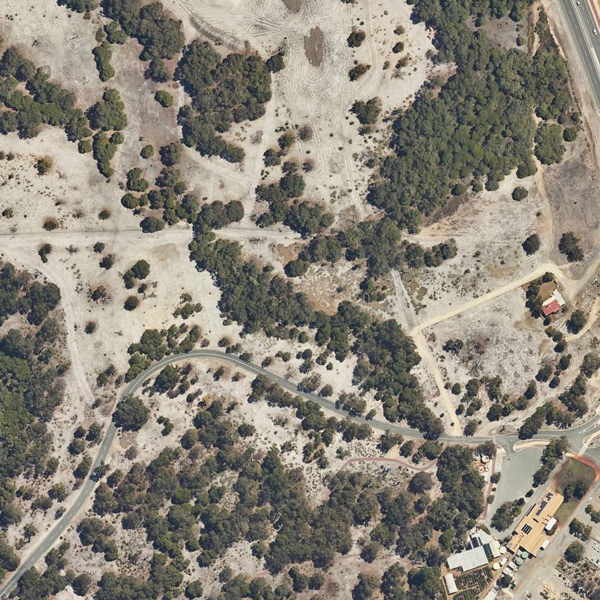
Bushfire management plan/Statement addressing
          the Bushfire Protection Criteria coversheet

Site address:        Metronet - Whiteman Park Station - Lots 98 and 811 Drumpellier Drive, Whiteman

Site visit:    Yes   ✔        No

Date of site visit (if applicable):    Day 26                                  Month May                                Year 2021

Report author or reviewer:         Linden Wears

WA BPAD accreditation level (please circle):

Not accredited                Level 1 BAL assessor                Level 2 practitioner           Level 3 practitioner   ✔
If accredited please provide the following.

BPAD accreditation number: 19809                       Accreditation expiry: Month June                                 Year 2022

Bushfire management plan version number:                 Rev 0

Bushfire management plan date: Day 16                                           Month September                         Year 2021

Client/business name: Perth Transport Authority

                                                                                                                         Yes        No

Has the BAL been calculated by a method other than method 1 as outlined in AS3959
(tick no if AS3959 method 1 has been used to calculate the BAL)?                                                                  ✔
                                                                                                                                  ✔
Have any of the bushfire protection criteria elements been addressed through the use of a
performance principle (tick no if only acceptable solutions have been used to address all of the
bushfire protection criteria elements)?

Is the proposal any of the following (see SPP 3.7 for definitions)?                                                         Yes     No
Unavoidable development (in BAL-40 or BAL-FZ)                                                                                       ✔
Strategic planning proposal (including rezoning applications)                                                                       ✔
High risk land-use                                                                                                                  ✔
Vulnerable land-use                                                                                                         ✔
None of the above

Note: Only if one (or more) of the above answers in the tables is yes should the decision maker (e.g. local government
      or the WAPC) refer the proposal to DFES for comment.

Why has it been given one of the above listed classifications (E.g. Considered vulnerable land-use as the
development is for accommodation of the elderly, etc.)?

 Vulnerable land use due to public transport use of the station

The information provided within this bushfire management plan to the best of my knowledge is true and correct:

       Signature of report author
                                                                                                        Date 16 September 2021
       or reviewer
Metronet – Whiteman Park
                                        Drumpellier Drive, Whiteman
                                                 Bushfire Management Plan
                                                                   Date: 16 September 2021
                                                Prepared For: Perth Transport Authority
                                             Linfire Ref: 20210416136LOR-BMP-002_0

                                                                           Linfire Consultancy
                                                                             ABN: 577 930 47299

    Revision      Issue Date      Revision Description                    Approved By

        0       16 Sept 2021      Issued for Approval         Linden Wears (Level 3 BPAD 19809)

Linfire Consultancy   PO Box 4031 Woodland WA 6018       M: +61 (0)433 528 511   E: linden@linfire.com.au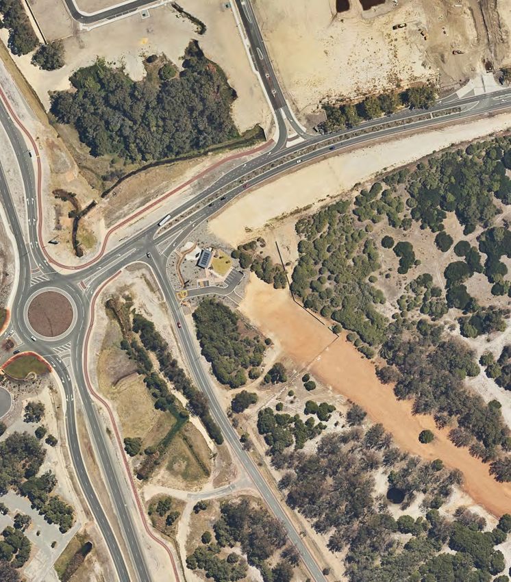
Metronet – Whiteman Park
                                                                                     Bushfire Management Plan

Disclaimer and Limitation
This report is prepared solely for the nominated client, and any future residents of the subject lot(s),
and is not for the benefit of any other person and may not be relied upon by any other person.

To the maximum extent permitted by the law, Linfire Consultancy, its employees, officers, agents
and the writer (“Linfire”) excludes all liability whatsoever for:
         1. claim, damage, loss or injury to any property and any person caused by fire or as a
            result of fire or indeed howsoever caused;
         2. errors or omissions in this report except where grossly negligent; and the proponent
            expressly acknowledges that they have been made aware of this exclusion and that
            such exclusion of liability is reasonable in all the circumstances.

If despite the provisions of the above disclaimer Linfire is found liable then Linfire limits its liability to
the lesser of the maximum extent permitted by the law and the proceeds paid out by Linfire’s
professional or public liability insurance following the making of a successful claim against such
insurer.

Fire is an unpredictable force of nature. Changing climatic factors (whether predictable or otherwise)
either before or at the time of a fire can also significantly affect the nature of a fire and in a bushfire
prone area it is not possible to completely guard against bushfire. The mitigation strategies contained
in this Bushfire Management Plan (BMP) are considered to be prudent minimum standards only,
based on the standards prescribed by relevant authorities. It is expressly stated that Linfire do not
guarantee that if such standards are complied with or if a property owner exercises prudence, that
a building or property will not be damaged or that lives will not be lost in a bush fire.

Further, the achievement of the level of implementation of fire precautions will depend on the actions
of the landowner or occupiers of the land, over which Linfire has no control. If the proponent
becomes concerned about changing factors then either a review of the existing BMP, or a new BMP,
should be requested. Linfire accepts no liability or responsibility whatsoever for or in respect of any
use or reliance upon this report and its supporting material by any third party.

20210416136LOR-BMP-002_0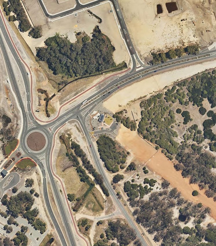
Metronet – Whiteman Park
                                                                                                                   Bushfire Management Plan

Table of Contents
1.0      Proposal details ..................................................................................................................... 5
  1.1         Background ........................................................................................................................ 5
  1.2         Site description .................................................................................................................. 6
  1.3         Habitable buildings and assets .......................................................................................... 6
  1.4         Purpose.............................................................................................................................. 7
  1.5         Other plans/reports ............................................................................................................ 7
2.0      Environmental considerations ............................................................................................. 11
  2.1         Native vegetation - modification and clearing .................................................................. 11
  2.2         Revegetation and Landscaping ....................................................................................... 12
3.0      Bushfire assessment results ................................................................................................ 14
  3.1         Assessment inputs ........................................................................................................... 14
      3.1.1      Vegetation classification .............................................................................................. 14
      3.1.2      Effective slope .............................................................................................................. 15
      3.1.3      Summary of inputs ....................................................................................................... 15
  3.2         Assessment outputs ........................................................................................................ 18
      3.2.1      Bushfire Attack Level (BAL) contour assessment........................................................ 18
4.0      Identification of bushfire hazard issues ............................................................................... 21
  4.1         Bushfire context ............................................................................................................... 21
  4.2         Bushfire hazard issues .................................................................................................... 21
  4.3         Bushfire safety strategy ................................................................................................... 21
5.0      Assessment against the bushfire protection criteria ............................................................ 23
  5.1         Compliance table ............................................................................................................. 23
  5.2         Additional management strategies .................................................................................. 27
      5.2.1      Onsite landscaping and revegetation .......................................................................... 27
      5.2.2      Road verge fuel management ..................................................................................... 27
      5.2.3      Building construction standards ................................................................................... 27
      5.2.4      Staging of access ........................................................................................................ 28
      5.2.5      Vulnerable land use and recommended development condition ................................. 28
      5.2.6      BAL compliance and/or BAL assessment report ......................................................... 29
      5.2.7      Compliance with annual firebreak notice ..................................................................... 29
6.0      Responsibilities for implementation and management of the bushfire measures ............... 30
7.0      References .......................................................................................................................... 32

Tables List
Table 1: Summary of environmental values .................................................................................... 11
Table 2: Post-development vegetation classifications/exclusions and effective slope .................... 15

20210416136LOR-BMP-002_0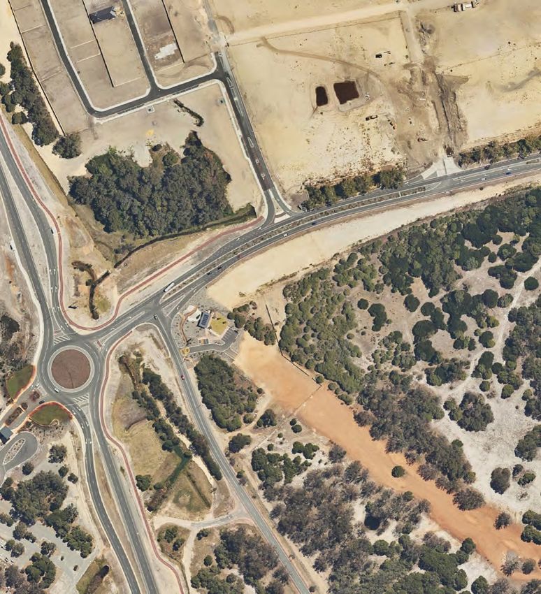
Metronet – Whiteman Park
                                                                                                               Bushfire Management Plan

Table 3: BAL contour assessment results to proposed buildings and assets ................................. 18
Table 4: BAL applicable to each building/element ........................................................................... 19
Table 5: Compliance with the bushfire protection criteria of the Guidelines .................................... 23
Table 6: Responsibilities for implementation and management of the bushfire measures ............. 30

Figures List
Figure 1: Development Plan .............................................................................................................. 9
Figure 2: Site overview .................................................................................................................... 10
Figure 3: Post-development vegetation classification and effective slope ...................................... 17
Figure 4: BAL contour map .............................................................................................................. 20

Plates List
Plate 1: Map of Bush Fire Prone Areas (DFES 2021) ....................................................................... 8

Appendices
Appendix 1: Vegetation plot photos and description ....................................................................... 34
Appendix 2: APZ standards (Schedule 1 of the Guidelines) ........................................................... 47
Appendix 3: Vehicular access technical standards of the Guidelines ............................................. 48
Appendix 4: City of Swan Firebreak Notice ..................................................................................... 52

20210416136LOR-BMP-002_0                                                                                                              Page 4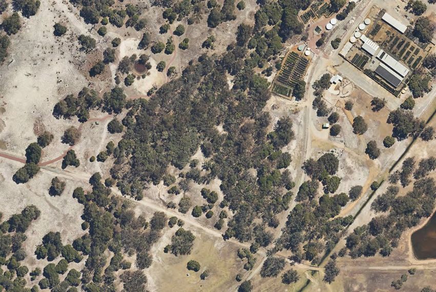
Metronet – Whiteman Park
Bushfire Management Plan
1.0 Proposal details
1.1 Background
Melconnx, on behalf of the Perth Transport Authority (PTA; the Proponent) is seeking to lodge a
Development Application (DA) in relation to proposed development of Whiteman Park Train Station
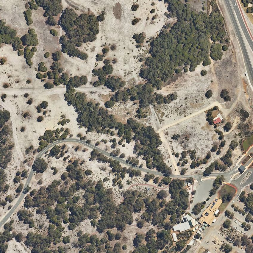
at Lots 98 and 811 Drumpellier Drive, Whiteman (the project area) located in the City of Swan.
The development plan (see Figure 1) identifies that the proposed development will comprise the
following elements:
• Station building with platform level (on raised viaduct) and concourse level (at grade
underneath the platform)
• Roof canopy
• Bus interchange
• Kiss n Ride drop off area
• Bus shelter
• Signalling Equipment Room (building) and radio mast
• Services area including bins, irrigation tanks
• Western Power infrastructure
• Fire pumps and tanks
• Welcome Place outdoor plaza
• Tram shelter
• Onsite roads consisting of:
o Public road – short section from Drumpellier Drive to Whiteman Park entrance
o Internal driveways
▪ Internal access roads
▪ Service roads
• Onsite carparking
• Pedestrian shared path (PSP) – footpaths
• Underpass to eastern side of Drumpellier Drive
• Onsite landscaping and drainage
• Metronet railway track, and associated batters (not included in this DA)
o Railway is on a viaduct at the station, that is raised above ground level
o The railway returns to grade to the south of the station and to the north of the
public access road
• Drumpellier Drive and Youle-Dean Road modification works to accommodate new
entrance road (not included in this DA)
• The PTA maintenance access track providing vehicular access along the western side
of the railway throughout Whiteman Park, to north and south of station (not included in
this DA)
The project area extends around the station development, including the carpark and the Signalling
Equipment Room building, as shown in Figure 2. The construction of the railway line, the
modification of Drumpellier Drive and the creation of the PTA maintenance access track, are all parts
of separate work packages and not part of this development application. It has been assumed as
part of this BMP that both the railway construction and Drumpellier Drive upgrade will be completed
20210416136LOR-BMP-002_0 Page 5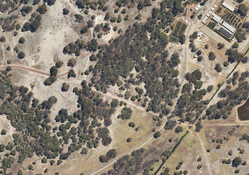
Metronet – Whiteman Park
                                                                                Bushfire Management Plan

prior to occupancy.

The station will be operated by PTA and is manned at all times that it is open to the public.

Vehicular access to the station for the public, is via the main entrance off Drumpellier Drive onto
Whiteman Drive East and into an internal driveway to the carpark and Kiss and Ride, with buses
able to enter the bus interchange via another entrance also from Whiteman Drive East. A service
road provides access to the Signalling Equipment Room located to the north.

The main entrance road to the carpark entrance road, is a public road that extends from Drumpellier
Drive to the Whiteman Park entrance (see Figure 2). There are four private driveway connections
to this road, including two that extend from the round-about in the centre of this public road.

The remainder of the roads within the project area are all considered private driveways including:
        •   the internal carpark roads including the Kiss ‘n’ Ride turnaround loop
        •   the bus interchange driveway
        •   the service road from the bus interchange driveway to the DFES booster connection
            and firewater pumps/tanks
        •   the service road to the Signalling Equipment Room (SER)
        •   the PTA maintenance access track (not included in this DA) however provisions for
            connections are to be made from the driveways near the SER and within the southern
            carpark.

Given the nature of the facility, this station has its own onsite fire hydrant system which consists of
dedicated fire water tanks, pump room and booster connection. Emergency management
provisions, including evacuation, is expected to be conducted in accordance with the PTA
Emergency Management Manual (EMM). Linfire note that while the PTA EMM details the response
to a variety of onsite emergencies, including station fires, there isn’t any specific information in the
EMM relating to bushfire emergencies, which may require different responses and evacuation
protocols to other emergencies. As outlined in Section 1.4, it is proposed that bushfire emergency
management measures be incorporated into the PTA EMM to satisfy bushfire policy requirements.

1.2   Site description

The project area extends around the overall development boundary for this development application,
as shown in Figure 2, and is surrounded by:
        •   remnant bushland and previously cleared land, to the north within Whiteman Park, with
            Drumpellier Drive and Whiteman Edge development further to the north-east
        •   Drumpellier Drive and Isoodon Street to the east, with a large median strip between
            them, with remnant bushland further east of Isoodon Street
        •   Grazed pastureland to the south, with Drumpellier Drive slightly further to the east
        •   remnant bushland within Whiteman Park to the west
The project area is largely cleared as part of the current development that exists on the site. The
existing road access is to be reconfigured as part of this development, with Whiteman Drive East to
be pushed further north, to accommodate the new station.

1.3   Habitable buildings and assets

Review of the proposed development has identified the following proposed habitable buildings and
assets that Linfire consider require protection from bushfire impact:
        •   Station building (largely beneath the main station canopy) on both the raised platform
            level and lower concourse level.

20210416136LOR-BMP-002_0                                                                          Page 6
Metronet – Whiteman Park
                                                                               Bushfire Management Plan

        •   Lift lobby building located immediately south of the main station canopy
        •   Crib/UAT building within the bus interchange loop
        •   The Signalling Equipment Room located to the north of the main station

The various buildings and assets are depicted on Figures 1 and 2..

1.4   Purpose

The project area contains proposed habitable development located within a designated bush fire
prone area that is subject to a BAL rating above BAL-Low. On this basis, this Bushfire Management
Plan (BMP) has been prepared to address requirements under Policy Measures 6.2 and 6.5 of State
Planning Policy 3.7 Planning in Bushfire-Prone Areas (SPP 3.7; WAPC 2015) and Guidelines for
Planning in Bushfire-Prone Areas (the Guidelines; WAPC 2017).

The proposed development is considered to be a vulnerable land use which triggers additional
requirements under Policy Measure 6.6 of SPP 3.7. In accordance with Policy Measure 6.6.1 and
Section 5.5 of the Guidelines, development applications for vulnerable land uses require a Bushfire
Emergency Evacuation Plan (BEEP) detailing the emergency management provisions for the facility,
accompanies the BMP.

For this project, it is proposed that a BEEP is not prepared at this time, but is included as a future
implementation measure within this BMP and conditioned as part of the DA approval. Linfire
consider the most appropriate approach is to have the proposed bushfire emergency management
arrangements for this station be incorporated into the existing PTA EMM to standardise the
procedures. To achieve this, there is a significant liaison process required with PTA, which given
occupation of the station by vulnerable occupants (i.e the public) isn’t likely until 2024, there is
considerable time to define these bushfire emergency management arrangements. This BMP will
provide some guidance about the overall strategy, to provide decision-makers some information
regarding the anticipated emergency management measures. Notwithstanding, a standalone BEEP
for the station may still be an option if this is PTA’s preference, however it should be aligned and
referenced in the EMM.

1.5   Other plans/reports

There are no known bushfire or assessments that have been prepared previously for the project
area.

20210416136LOR-BMP-002_0                                                                        Page 7
Metronet – Whiteman Park
                                                    Bushfire Management Plan

Plate 1: Map of Bush Fire Prone Areas (DFES 2021)

20210416136LOR-BMP-002_0                                             Page 8
Figure 1: Development Plan 20210416136LOR_Fig 1 Aug-2021
Legend

            Proposed Development

            Project Area

            100m Assessment Area

            150m Assessment Area

            Building Outline

            Private Driveway

            Public Road

            PTA Maintenance Access

          Scale 1: 3,500

                           Linfire Consultancy
                           A PO Box 4031 Woodlands WA 6018
                           M +61 (0)433 528 511
                           E linden@linfire.com.au

Public Transport Authority

Metronet: Whiteman Park Station

Figure 2: Site Overview

© 2021. GIS Pro makes no claims, no representations, and no warranties, express
or implied, concerning the validity (express or implied), the reliability or the
accuracy of the GIS data and GIS data products, including the implied validity of
any uses of such data.
Street Map Sources: Map data ©2021 Google. Hybrid Imagery: Images © Google
Imagery, CNES, Airbus, Maxar Technologies. OSM Streetmap: © OpenStreetMap
contributors. Date Printed: 02-09-2021
Metronet – Whiteman Park
Bushfire Management Plan
2.0 Environmental considerations
2.1 Native vegetation - modification and clearing
The project area has largely been cleared of native vegetation as part of existing development,
however some small plots of remnant vegetation may require clearing as part of the proposal. Table
1 provides a summary of a search of free publicly available environmental data.
Linfire understand all environmental impacts resulting from implementation of the proposal, if any,
will be addressed under standard State and Federal environmental assessment and referral
requirements under the Environmental Protection Act 1986 and Environment Protection and
Biodiversity Conservation Act 1999.
Table 1: Summary of environmental values
Environmental Not mapped as Mapped as occurring Description
value occurring within or adjacent to the
within or project area
adjacent to the
project area Within Adjacent
Environmentally An Environmentally Sensitive
Sensitive Area Area have been identified
✓ ✓ within, and adjacent, to the
project area, in the land west of
Drumpellier Drive
Swan Bioplan No Regionally Significant
Regionally
Significant Natural ✓ Natural Areas were identified.
Area
Ecological linkages This layer not publicly available
N/A N/A N/A at the time of document
preparation.
Wetlands A Conservation Category
wetland has been identified to
the west of the project area,
with a Multiple Use wetland
located along the southern
boundary and another to the
north of the site.
✓ ✓ Resource Enhancement
wetlands are located to the
north, west and east of the
project area. located over the
eastern portion of the project
area.
No Ramsar sites are mapped
as occurring within or adjacent
to the project area.
Waterways No waterways or lakes within or
adjacent to the project site.
During the inspection, a local
✓ waterway was noted to the west
of the project area and a small
dam in agricultural land to the
south.
20210416136LOR-BMP-002_0 Page 11Metronet – Whiteman Park
Bushfire Management Plan
Environmental Not mapped as Mapped as occurring Description
value occurring within or adjacent to the
within or project area
adjacent to the
project area Within Adjacent
Threatened National Map shows the project
Ecological
Communities listed ✓ ✓ area and the surrounding area
as containing Threatened
under the EPBC Act Ecological Communities.
Threatened and This layer not publicly available
priority flora N/A N/A N/A at the time of document
preparation.
Fauna habitat listed Land within the project area is
under the EPBC Act mapped as being a potential
roosting area for endangered
Carnaby’s Black Cockatoo, and
✓ also an area requiring
investigation for feeding habitat.
The project area shows no
potential Western Ringtail
Possum habitat.
Threatened and This layer not available at the
N/A N/A N/A
priority fauna time of document preparation.
Bush Forever Site Bush Forever site 304 is
✓ ✓ located within the project area
and across land to the north,
south and west of the site
DBCA managed No DBCA managed or
lands and waters legislated land and waters were
(includes legislated
lands and waters ✓ identified within or adjacent to
the project area.
and lands of
interest)
Conservation No information has been
covenants ✓ provided by the client regarding
Conservation Covenants.
Aboriginal Heritage Land adjacent to the project
✓ area, namely the west and
north, are mapped as being a
Register Aboriginal Sites.
Crown Reserves No Crown Reserves were
✓ identified within or adjacent to
the project area.
2.2 Revegetation and Landscaping
The proposed development is to include a combination of proposed revegetation and onsite
managed landscaping as part of the proposal. The landscaping strategy for the project area is to
include the following treatments:
20210416136LOR-BMP-002_0 Page 12Metronet – Whiteman Park
Bushfire Management Plan
• Asset Protection Zones (APZs) are to be implemented around nominated buildings, to
the dimensions detailed in this BMP, and complying with the APZ standards from the
Guidelines (see Schedule 1 in Appendix 2).
• Outside the APZs, the managed landscaping within the main station development area
is to consist of either non-vegetated elements or low threat landscaping in accordance
with AS 3959—2018 Clauses 2.2.3.2 (e) and (f).
o landscaping beneath the viaduct, that is outside nominated APZs, is to be low
threat vegetation compliant with AS 3959 Clause 2.2.3.2 (f).
o landscaping within the carpark and, along the roads and around the proposed
station is to be low threat vegetation compliant with AS 3959 Clause 2.2.3.2 (f).
o landscaping surrounding the proposed pedestrian underpass is to be low threat
vegetation compliant with AS 3959 Clause 2.2.3.2 (f).
• proposed landscaping along the western and south-western interfaces of the carpark is
assumed will likely return to a Class A forest vegetation structure over time given the
connection to Whiteman Park.
Linfire understand that there will be no unmanaged vegetation (classified vegetation) along the rail
alignment, within 150 m of the project area. As such, the proposed rail alignment has been excluded
from classification on the basis it will be non-vegetated or managed as low threat vegetation.
20210416136LOR-BMP-002_0 Page 13Metronet – Whiteman Park
Bushfire Management Plan
3.0 Bushfire assessment results
3.1 Assessment inputs
3.1.1 Vegetation classification
Linfire assessed classified vegetation and exclusions within 150 m of the project area through on-
ground verification on 26 May 2021 in accordance with AS 3959—2018 Construction of Buildings in
Bushfire-Prone Areas (AS 3959; SA 2018) and the Visual Guide for Bushfire Risk Assessment in
Western Australia (DoP 2016). Georeferenced site photos and a description of the vegetation
classifications and exclusions are depicted in Figure 3 and Table 2.
The following vegetation classifications were identified during the site inspection within the project
area and adjacent 150 m assessment area:
• Class A forest
o Occurs extensively to the north, south and west of the project area within
Whiteman Park, with mature trees (>6m high) and, multi-layer understorey
vegetation.
o Also occurs in smaller plots to the north-east, east and south-east of
Drumpellier Drive.
o Landscaping along the south-western and western boundary of the carpark is
assumed to be Class A forest classification given the connection to Whiteman
Park
• Class G grassland
o Smaller plots of unmanaged grassland with isolated mature trees occur to the
north and south of the project area within Whiteman Park, and also the north-
east, east and south-west of Drumpellier Drive.
• Class C shrubland
o A small plot of reeds (Metronet – Whiteman Park
Bushfire Management Plan
completion of the proposed station, the railway alignment construction and the surrounding road
works. This includes the following:
• the railway alignment, where on-grade to the north and south of the viaduct structure,
being constructed and maintained in a non-vegetated state (or low threat vegetation,
however this is unlikely)
• Drumpellier Drive and Youle-Dean Road Road reserves, and Whiteman Drive East will
be established and maintained as non-vegetated and low threat vegetation
3.1.2 Effective slope
Linfire assessed effective slope under classified vegetation through on-ground verification on 26
May 2021 in accordance with AS 3959. Results were cross-referenced with Landgate 5m contour
data and are depicted in Table 2 and Figure 3.
Site observations indicate that land within the project area, and within the 150 m assessment area,
are situated on land that is relatively flat but does have localised gentle slopes, with variation in
slope beneath classified vegetation ranging from flat/upslope to less than 5° downslope in relation
to the project area. On this basis, Linfire has assigned effective slopes accordingly, ranging from
flat/upslope to downslope 0°-5° for the various classified vegetation plots.
3.1.3 Summary of inputs
Table 2 illustrates the anticipated post-development vegetation classifications and exclusions
following completion of development works and modification of existing vegetation to a non-
vegetated or low threat state, throughout much of the project area and along the railway alignment
and batters. The post-development vegetation classifications/exclusions and effective slope are
summarised in Table 2.
Table 2: Post-development vegetation classifications/exclusions and effective slope
Vegetation Vegetation Effective slope Comments
plot classification
1 Class G Grassland Flat/upslope (0°) Plots of unmanaged grassland vegetation to
the north, north-east and south of the project
area
2 Class G Grassland Downslope >0–5° Small plot of grassland to the south-west of
the project area with others to the east and
south-east of Drumpellier Drive
3 Class A Forest Flat/upslope (0°) Significant plots of remnant forest vegetation
to the north, west, south and north-east of
the project area. Contains vegetation >6m
in height, typically with multi-layered
understorey.
4 Class A Forest Downslope >0–5° Plots of remnant forest vegetation to the
south and west of the project area, including
areas of proposed revegetation, with other
plots to the east and south-east of
Drumpellier Drive. Contains vegetation >6m
in height, typically with multi-layered
understorey.
5 Class C Shrubland Downslope >0–5° Small plot of shrubland vegetation to the
north-east of the project area within
drainage swale.
20210416136LOR-BMP-002_0 Page 15Metronet – Whiteman Park
Bushfire Management Plan
Vegetation Vegetation Effective slope Comments
plot classification
6 Excluded – Clause N/A Unmanaged vegetation located further than
2.2.3.2 [a] 100 m from the project area
7 Excluded – Non- N/A Existing non-vegetated elements (buildings,
vegetated and Low roads etc) and low threat vegetation,
threat (Clause 2.2.3.2 adjacent to the project area
[e] and [f])
8 Excluded – Non- N/A Existing classified vegetation within the
vegetated and Low project area to be modified to non-vegetated
threat (Clause 2.2.3.2 or low threat vegetation as part of the
[e] and [f]) proposed development
This includes the non-vegetated elements
and managed landscaping within the project
area, the APZs and the railway reserve.
The proposed vegetation within the carpark
has been excluded on the basis that it will
be managed by the PTA on an ongoing
basis, and the vegetation is contained in
isolated
20210416136LOR-BMP-002_0 Page 16Legend
Site Photo
Contours
Proposed Development
Project Area
100m Assessment Area
150m Assessment Area
Building Outline
Asset Protection Zone
17m
21m
50m
Vegetation Plot
Classified Vegetation
A. Forest
C. Shrubland
G. Grassland
Excluded Clause 2.2.3.2(a)
Excluded Clause 2.2.3.2(e&f)
Modified to non vegetated and low threat
Scale 1: 3,500
Linfire Consultancy
A PO Box 4031 Woodlands WA 6018
M +61 (0)433 528 511
E linden@linfire.com.au
Public Transport Authority
Metronet: Whiteman Park Station
Figure 3: Post-development vegetation
classification and effective slope
© 2021. GIS Pro makes no claims, no representations, and no warranties, express
or implied, concerning the validity (express or implied), the reliability or the
accuracy of the GIS data and GIS data products, including the implied validity of
any uses of such data.
Street Map Sources: Map data ©2021 Google. Hybrid Imagery: Images © Google
Imagery, CNES, Airbus, Maxar Technologies. OSM Streetmap: © OpenStreetMap
contributors. Date Printed: 02-09-2021Metronet – Whiteman Park
Bushfire Management Plan
3.2 Assessment outputs
3.2.1 Bushfire Attack Level (BAL) contour assessment
Linfire has undertaken a BAL contour assessment in accordance with Method 1 of AS 3959 for the
project area (see Figure 4). The Method 1 procedure incorporates the following factors:
• state-adopted FDI 80 rating
• vegetation classification
• effective slope
• distance maintained between proposed development areas and the classified
vegetation.
The BAL rating gives an indication of the level of bushfire attack (i.e. the radiant heat flux) that may
be received by proposed future development and subsequently informs the standard of building
construction and/or setbacks required for proposed habitable development to potentially withstand
such impacts.
The BAL contours are based on:
• the vegetation classifications and effective slope observed at the time of inspection as
well as consideration of the post-development conditions resulting from proposed on-
site clearing extent and vegetation management including APZ’s, resultant vegetation
exclusions and separation distances achieved in line with the Development Plan and
Sections 2.2 and 3.1.1
• the proposed landscaping around the south-western and western extents of the carpark,
likely returning to a Class A forest classification as per AS 3959, given connection to
Whiteman Park
• the Proponent maintains landscaping within station development area, including
beneath the viaduct, within the carpark and adjacent to the pedestrian underpass, as
low threat vegetation on an ongoing basis to enable exclusion of the carpark as non-
vegetated and low threat vegetation under Clauses 2.2.3.2 (e) and (f).
Should there be any changes in development design or classified vegetation extent that results in a
modified BAL outcome, then the BAL contours will need to be reassessed.
The results of the BAL contour assessment are detailed in Table 3 and illustrated in Figure 4. The
highest BAL applicable to the proposed buildings and elements is BAL-12.5, following
implementation of the proposed Asset Protection Zones and other vegetation modification in line
with the Landscaping Plan ensuring all development will be in BAL-29 or less. It is noted that the
SER building could increase to BAL-29 if land to the north becomes Class A forest,
Table 3: BAL contour assessment results to proposed buildings and assets
Method 1 BAL determination
Plot Vegetation classification Effective slope Separation Highest BAL
distance
1 Class G Grassland Flat/upslope (0°) 21 m BAL–12.5
2 Class G Grassland Downslope >0–5° 56 m BAL–Low
3 Class A Forest Flat/upslope (0°) 42 m BAL–12.5
4 Class A Forest Downslope >0–5° 90 m BAL–12.5
5 Class C Shrubland Downslope >0–5° >100 m BAL–Low
20210416136LOR-BMP-002_0 Page 18Metronet – Whiteman Park
Bushfire Management Plan
Method 1 BAL determination
Plot Vegetation classification Effective slope Separation Highest BAL
distance
6 Excluded – Clause 2.2.3.2 [a] N/A N/A BAL–Low
7 Excluded – Non-vegetated and Low N/A N/A BAL–Low
threat (Clause 2.2.3.2 [e] and [f])
8 Excluded – Non-vegetated and Low N/A N/A BAL–Low
threat (Clause 2.2.3.2 [e] and [f])
Table 4 lists the BAL applicable to each building or element within the proposed development.
Table 4: BAL applicable to each building/element
Building / element Initial BAL Proposed vegetation Revised
(no management) management BAL
Station building BAL–FZ 17 m -50 m variable width APZ BAL–12.5
around the building, in conjunction
with onsite landscaping and
revegetation and the proposed
clearing along the rail alignment.
Signalling Equipment Room BAL–FZ 21 m wide APZ around the BAL–12.5
building, in conjunction with onsite
landscaping and revegetation and
the proposed clearing along the
rail alignment.
The 21 m APZ around this
building is to allow for future
regrowth or revegetation of Class
A forest around the building,
especially from the north.
Crib/UAT Building BAL–FZ Onsite landscaping and BAL–12.5
revegetation and the proposed
clearing along the rail alignment.
20210416136LOR-BMP-002_0 Page 19Legend
DFES Booster
Fire Pumps and Tanks
Street Hydrant
Proposed Development
Project Area
100m Assessment Area
150m Assessment Area
Building Outline
Asset Protection Zone
17m
21m
50m
Vegetation Plot
BAL Contours
BAL FZ
BAL 40
BAL 29
BAL 19
BAL 12.5
BAL Low
Scale 1: 3,500
Linfire Consultancy
A PO Box 4031 Woodlands WA 6018
M +61 (0)433 528 511
E linden@linfire.com.au
Public Transport Authority
Metronet: Whiteman Park Station
Figure 4: BAL Contour Plan
© 2021. GIS Pro makes no claims, no representations, and no warranties, express
or implied, concerning the validity (express or implied), the reliability or the
accuracy of the GIS data and GIS data products, including the implied validity of
any uses of such data.
Street Map Sources: Map data ©2021 Google. Hybrid Imagery: Images © Google
Imagery, CNES, Airbus, Maxar Technologies. OSM Streetmap: © OpenStreetMap
contributors. Date Printed: 02-09-2021Metronet – Whiteman Park
Bushfire Management Plan
4.0 Identification of bushfire hazard issues
4.1 Bushfire context
The project area is located on the western side of Whiteman Park, which contains primarily native
forest vegetation with some previously cleared or grazed land especially to the south. In close
proximity to the east of the project area is Drumpellier Drive with Whiteman Edge residential
subdivision location further to the north-east. To the east and south-east is remnant grassland and
forest vegetation between Drumpellier Drive and Isoodon Street, with primarily forest vegetation
further to the east of Isoodon Street.
The greatest bushfire threat to the proposed development is from Whiteman Park to the west, south-
west and north-west of the project area in the form of forest and grassland vegetation. Bushfires
from these directions would spread to the project area on fire runs of 3-5 kilometres and would be
expected to be fully-developed bushfire behaviour with elevated radiant heat and ember attack.
A bushfire approaching from the east or south-east would still be on a fire run of at least 2 km long,
and would be expected to exhibit steady state bushfire behaviour through forest and grassland
vegetation. Permanent separation is provided from the project area by Drumpellier Drive and the
proposed railway alignment, however the impact from would still be elevated radiant heat and ember
attack.
Based on the above, bushfire impact on the proposed development could be the fully-developed
bushfire behaviour anticipated by AS 3959, which would result in buildings receiving elevated levels
of radiant heat and ember attack, if left unmanaged.
4.2 Bushfire hazard issues
Examination of the environmental considerations (Section 2.0) and the bushfire risk assessment
(Section 3.0) has identified the following bushfire hazard issues:
1. Based on the existing extent of vegetation outside proposed buildings and roads, the
proposed facility is subject to an initial BAL of BAL-FZ. In order for the habitable
buildings and other assets to achieve a compliant rating of BAL-29 or less, sufficient
separation will be required in the form of APZs, low threat vegetation or permanent non-
vegetated elements
2. Ensuring sufficient vehicular access to the proposed development, to enable egress by
onsite occupants and facilitating access for fire brigade and emergency services.
3. Ensuring access to bushfire fighting water supply, to limit the travel time to water
supplies for appliance refills.
4. The proposed development constitutes a vulnerable land use, primarily due to the
presence of the public who may not be familiar with the facility or what to do in a bushfire
emergency.
4.3 Bushfire safety strategy
The following bushfire safety strategy is proposed to demonstrate compliance with the Bushfire
Protection Criteria of the Guidelines and address the bushfire hazards identified above:
1. Create sufficient separation from surrounding classified vegetation, by ensuring
appropriately sized APZs are implemented around proposed buildings and asset, and
comply with the APZ standards of the Guidelines. Given the importance of the station
building, the decision has been made to implement an APZ to voluntarily achieve BAL-
12.5 or lower.
2. Providing compliant vehicular access within, to and from the proposed development,
20210416136LOR-BMP-002_0 Page 21Metronet – Whiteman Park
Bushfire Management Plan
consisting of public roads and private driveways, to enable occupant egress and
facilitate firefighter access to the project area and in particular the firewater supply.
3. Providing a secure bushfire fighting water supply by installing the proposed on-site fire
hydrant system to provide hydrant coverage to the station building. Static water tanks
on the hydrant system will also enable refill of bushfire fighting appliances from the fire
booster connection.
4. Ensure appropriate bushfire emergency management procedures are incorporated into
the overarching PTA EMM, to enable onsite staff to appropriately manage a bushfire
event impacting the proposed development including:
a. Monitoring of forecast Fire Danger Rating during bushfire season, and Total Fire
Ban Days, to anticipate bushfire risk for the next day and consider pre-emptive
actions
b. Maintaining situational awareness during day in bushfire season by monitoring
emergency services information
c. Emergency management procedures for bushfire events including ceasing train
and bus services and evacuating the train station.
Based on the above, Linfire considers the bushfire hazards within and adjacent to project area and
the associated bushfire risks are manageable through standard management responses outlined in
the Guidelines. These responses will be factored into proposed development as early as possible
at all stages of the planning process to ensure a suitable, compliant and effective bushfire
management outcome is achieved for protection of future life, property and environmental assets.
20210416136LOR-BMP-002_0 Page 22Metronet – Whiteman Park
Bushfire Management Plan
5.0 Assessment against the bushfire protection criteria
5.1 Compliance table
An acceptable solutions assessment against the bushfire protection criteria is provided in Table 5.
Table 5: Compliance with the bushfire protection criteria of the Guidelines
Bushfire protection criteria Development response
Element Intent Performance Principle Acceptable solutions Method of Proposed bushfire management measures Compliance Comment
compliance
Element 1: To ensure that Performance Principle P1 A1.1 Development location Acceptable Solution The BAL contour map (see Figure 4) indicates that all proposed • Compliance of the
Location strategic planning The strategic planning proposal, subdivision buildings and infrastructure can be sited in an area of BAL-29 or lower, Performance Principle
Development location
proposals, and development application is located in an upon completion of development and implementation of the proposed and Intent of Element 1
The strategic planning proposal, subdivision
subdivision and area that is or will, on completion, be subject Asset Protection Zones (APZs) and other onsite landscaping, in is achieved through
and development application is located in an
development to either a moderate or low bushfire hazard addition to the construction of the railway line and reworking of compliance with
area where the bushfire hazard assessment
applications are level, or BAL–29 or below. Drumpellier Drive, Youle-Dean Road and Whiteman Drive East. Acceptable Solution
is or will, on completion, be moderate or low,
located in areas A1.1
or a BAL-29 or below, and the risk can be The decision has been made to voluntarily achieve BAL-12.5 or lower
with the least managed. For unavoidable development in on the station building, and the APZ around this building has been
possible risk of areas where BAL-40 or BAL-FZ applies, sized on this basis. The APZ around the SER building allows for
bushfire to facilitate demonstrating that the risk can be managed future potential regrowth or revegetation of Class A forest around the
the protection of to the satisfaction of the Department of Fire building, especially from the north.
people, property and Emergency Services and the decision-
and infrastructure. maker.
Element 2: To ensure that the Performance Principle P2 A2.1 Asset Protection Zone (APZ) Acceptable Solution On completion of development, the following APZs are to be • Compliance of the
Siting and siting and design of Every habitable building is surrounded by, implemented as non-vegetated elements or maintained low threat Performance Principle
The siting and design of the strategic
design of development and every proposed lot can achieve, an APZ vegetation: and Intent of Element 2
planning proposal, subdivision or
developme minimises the level depicted on submitted plans, which meets the is achieved through
development application, including roads, • Station building: 17m to 50m wide APZ
nt of bushfire impact. following requirements: compliance with
paths and landscaping, is appropriate to the • Signal Equipment building: 21m wide APZ
Acceptable Solution
level of bushfire threat that applies to the Width: Measured from any external wall or The APZs are to be implemented and maintained in accordance with A2.1
site. That it incorporates a defendable space supporting post or column of the proposed Schedule 1 of the Guidelines (see Appendix 2).
and significantly reduces the heat intensities building, and of sufficient size to ensure the
at the building surface thereby minimising potential radiant heat impact of a bushfire The APZ for the Station building extends east into Drumpellier Drive
the bushfire risk to people, property and does not exceed 29kW/m² (BAL–29) in all road reserve, which is under MRWA tenure, with the existing road
infrastructure, including compliance with AS circumstances. verge currently being well managed in this area. It is understood that
3959 if appropriate. liaison with MRWA is occurring to ensure that the portion of the APZ
Location: the APZ should be contained within the road verge will be established and maintained in accordance
solely within the boundaries of the lot on with APZ standards, in perpetuity.
which the building is situated, except in
instances where the neighbouring lot or lots In addition to the nominated APZs, the following areas are to be
will be managed in a low-fuel state on an maintained in a non-vegetated or low threat state to ensure ongoing
ongoing basis, in perpetuity (see explanatory exclusion in accordance with AS 3959 Clauses 2.2.3.2 (e) and (f):
notes) • Land beneath the viaduct, outside of nominated APZs
Management: the APZ is managed in • Alongside the railway, including batters, within 150 m of the
accordance with the requirements of project area
‘Standards for Asset Protection Zones’ (see • Landscaping around the main station building
Guidelines Schedule 1). • Landscaping within, and alongside, the carparks
• Landscaping alongside the pedestrian underpass and on
eastern side of Drumpellier Drive
The establishment of the above requirements, and all ongoing
management, is to be conducted in accordance with this BMP, which
is enforceable under the City of Swan firebreak notice (see Appendix
4).
Element 3: To ensure that the Performance Principle P3 A3.1 Two access routes Acceptable Solution The proposed public road network will provide all occupants with the • Compliance of the
Vehicular vehicular access The internal layout, design and construction Two different vehicular access routes are option of travelling to more than two different destinations from the Performance Principle
serving a of public and private vehicular access and provided, both of which connect to the public and Intent of Element 2
20210416136LOR-BMP-002_0 Page 23Metronet – Whiteman Park
Bushfire Management Plan
Bushfire protection criteria Development response
Element Intent Performance Principle Acceptable solutions Method of Proposed bushfire management measures Compliance Comment
compliance
access subdivision/develop egress in the subdivision / development road network, provide safe access and connection to Drumpellier Drive: is achieved through
ment is available allow emergency and other vehicles to move egress to two different destinations and are • providing the option of travelling south to Marshall Road where compliance with
and safe during a through it safely and easily. available to all residents/the public at all times further travel is possible to the east, west or further south. Acceptable Solution
bushfire event. and under all weather conditions. • providing the option of travelling north to Gnangara Road where A3.1, A3.2, A3.3, A3.5
further travel can be undertaken further north or east or west on and A3.8
Gnangara Road.
• providing the option of travelling further east on Youle-Dean
Road.
In this regard, the proposed development is provided with at least two
access routes which meets the requirements of Acceptable Solution
A3.1.
A3.2 Public road Acceptable Solution All public roads proposed as part of the development are to be
A public road is to meet the requirements in constructed to the relevant technical requirements of the Guidelines
Table 2, Column 1. (see Appendix 3).
The existing public roads sighted whilst travelling to the site appeared
compliant with public road specifications of the Guidelines and will be
sufficient for emergency egress or firefighter access to the site.
A3.3 Cul-de-sac (including a dead-end-road) Acceptable Solution A public road less than 200 m in length is proposed to the west of
A cul-de-sac and/or a dead-end road should Drumpellier Drive, to the Whiteman Park entrance (see Figure 2). This
be avoided in bushfire prone areas. Where road essentially continues on as Whiteman Drive East further to the
no alternative exists (i.e. the lot layout already west, and while it won’t have a turnaround at the termination, provision
exists and/or will need to be demonstrated by to turnaround will be possible using the loop road within the carpark to
the proponent), detailed requirements will the south. Additionally, there will be a roundabout within the short
need to be achieved (refer to the Guidelines section of road, and on this basis, there is considered to be sufficient
for detailed cul-de-sac requirements). provision for vehicle turnaround along the public road.
On this basis, other than the 17.5 m diameter turn-around head, this
section of road is to be constructed to the relevant technical
requirements of the Guidelines (see Appendix 3).
A3.4 Battle-axe Not applicable No battle-axe legs are proposed as part of the development and the
Battle-axe access leg’s should be avoided in project area is not serviced by an existing battle-axe.
bushfire prone areas. Where no alternative
exists, (this will need to be demonstrated by
the proponent) detailed requirements will
need to be achieved (refer to the Guidelines
for detailed battle-axe requirements).
A3.5 Private driveway longer than 50 m Acceptable Solution The proposed private driveways are depicted on Figure 2, and include:
A private driveway is to meet detailed • the internal carpark roads including the Kiss ‘n’ Ride
requirements (refer to the Guidelines for turnaround loop (note: Figure 2 doesn’t highlight all internal
detailed private driveway requirements). roads within the carpark).
• the bus interchange driveway
• the service road from the bus interchange driveway to the
DFES booster connection and firewater pumps/tanks
• the service road to the Signalling Equipment Room (SER)
• the PTA maintenance access track (not included in this DA)
however provisions for connections are to be made from the
driveways near the SER and within the southern carpark.
The private driveways will be constructed in accordance with the
technical requirements of the Guidelines for private driveways (see
Appendix 3). Most proposed roads will exceed 6 m in width, so
passing bays are not considered to be required within the project area.
20210416136LOR-BMP-002_0 Page 24Metronet – Whiteman Park
Bushfire Management Plan
Bushfire protection criteria Development response
Element Intent Performance Principle Acceptable solutions Method of Proposed bushfire management measures Compliance Comment
compliance
Similarly compliant turning arrangements are provided for all driveway
dead-ends which are generally configured as loop roads
A3.6 Emergency access way Not applicable The proposed development does not require Emergency Access Ways
An access way that does not provide through (EAWs) to provide through access to a public road.
access to a public road is to be avoided in
bushfire prone areas. Where no alternative
exists (this will need to be demonstrated by
the proponent), an emergency access way is
to be provided as an alternative link to a
public road during emergencies. An
emergency access way is to meet detailed
requirements (refer to the Guidelines for
detailed EAW requirements).
A3.7 Fire service access routes (perimeter Not applicable The proposed development does not require fire service access routes
roads) (FSARs) to achieve access within and around the perimeter of the
Fire service access routes are to be project area.
established to provide access within and
around the edge of the subdivision and
related development to provide direct access
to bushfire prone areas for fire fighters and
link between public road networks for
firefighting purposes. Fire service access
routes are to meet detailed requirements
(refer to the Guidelines for detailed fire
service access route requirements).
A3.8 Firebreak width Acceptable Solution On completion of development, the project area will be developed with
Lots greater than 0.5 hectares must have an non-vegetated surfaces, cleared land and low threat landscaping with
internal perimeter firebreak of a minimum some revegetation along the western and southern project area
width of three metres or to the level as extents. Given the public road and private driveway network provides
prescribed in the local firebreak notice issued sufficient access to the perimeter of the development, perimeter
by the local government. firebreaks are not considered to be required around the project area.
Access to the railway is to be provided by the PTA maintenance
access track, which will also connect to the existing internal Whiteman
Park access tracks. The PTA maintenance access track will connect
into the proposed development at two locations, as depicted on Figure
2, to enable emergency services to enter or exit this access route. It is
understood that the PTA maintenance access track is to be
constructed in accordance with the private driveway standards, which
would exceed the requirements of the City of Swan firebreak notice
(see Appendix 4).
20210416136LOR-BMP-002_0 Page 25Metronet – Whiteman Park
Bushfire Management Plan
Bushfire protection criteria Development response
Element Intent Performance Principle Acceptable solutions Method of Proposed bushfire management measures Compliance Comment
compliance
Element 4: To ensure that Performance Principle P4 A4.1 Reticulated areas Not applicable The proposed development is not located within an existing reticulated • Compliance of the
Water water is available to The subdivision, development or land use is area, however a Water Corporation town main is to be extended to the Performance Principle
The subdivision, development or land use is
the subdivision, provided with a reticulated water supply in project area to provide water supply to the development. At this stage and Intent of Element 4
provided with a permanent and secure water
development or accordance with the specifications of the it is not clear whether street hydrants will also be installed on the new is achieved through
supply that is sufficient for firefighting
land use to enable relevant water supply authority and main, and as such this has not been relied upon to achieve compliance with
purposes.
people, property Department of Fire and Emergency Services. compliance with A4.1. Acceptable Solution
and infrastructure to A4.2
The nearest existing street hydrants are located Youle-Dean Road,
be defended from approximately 350 m from the project area. Whilst the project area is
bushfire. located near these street hydrants, the main bushfire fighting water
supply is likely to be accessed from the dedicated onsite fire hydrant
system detailed below in A4.2 below.
A4.2 Non-reticulated areas Acceptable Solution The proposed development is to have an on-site fire hydrant system,
Water tanks for firefighting purposes with a designed, installed and maintained in accordance with the National
hydrant or standpipe are provided and meet Construction Code and relevant Australian Standards.
detailed requirements (refer to the Guidelines The fire hydrant system is expected to include dedicated firewater
for detailed requirements for non-reticulated storage tanks, duty/standby pumpset and booster connection located
areas). between the main station building and the bus interchange. Onsite fire
hydrants are sited throughout the development provide attending fire
fighters with fire hydrant coverage of the station building, including the
platform and concourse levels.
Given the onsite water storage (and infill) associated with the
proposed wet fire systems, the addition of an extra 50 kL to the
proposed storage capacity for bushfire fighting purposes is considered
appropriate. This static water supply will be available for attending
firefighters from the firewater storage tanks, via the booster
connection. Appliance access to the booster connection, and
turnaround, will be achieved using the loop service road that connects
to the bus interchange road.
The firewater tank/s are to be installed, filled and maintained for the
life of the project by the Proponent.
A4.3 Individual lots within non-reticulated Not applicable The proposed development is being addressed in accordance with
areas (Only for use if creating 1 additional lot A4.2
and cannot be applied cumulatively)
Single lots above 500 m2 need a dedicated
static water supply on the lot that has the
effective capacity of 10,000 L.
20210416136LOR-BMP-002_0 Page 26You can also read