Subsidence of rice paddy and upland crop fields in Shinotsu Peatland, Hokkaido, Japan - PIAHS
←
→
Page content transcription
If your browser does not render page correctly, please read the page content below
Tenth International Symposium on Land Subsidence (TISOLS)
Proc. IAHS, 382, 231–235, 2020
https://doi.org/10.5194/piahs-382-231-2020                                                                           Open Access
© Author(s) 2020. This work is distributed under
the Creative Commons Attribution 4.0 License.

              Subsidence of rice paddy and upland crop fields in
                    Shinotsu Peatland, Hokkaido, Japan
                                   Minoru Yokochi1 , Koichi Sekimoto2 , and Takashi Inoue3,4
                      1 Graduate  School of Global Food Resources, Hokkaido University, Sapporo, Japan
                            2 Graduate School of Agriculture, Hokkaido University, Sapporo, Japan
                            3 Research Faculty of Agriculture, Hokkaido University, Sapporo, Japan
            4 Global Station for Food, Land and Water Resources, GI-CoRE, Hokkaido University, Sapporo, Japan

                           Correspondence: Minoru Yokochi (mino_violalala@eis.hokudai.ac.jp)

                                                      Published: 22 April 2020

       Abstract. Agricultural land use on peatlands inevitably causes ongoing land surface subsidence resulting in a
       reduction of productivity. In addition, oxidation of the peat substrate associated with subsidence is responsible
       for greenhouse gas emission with the ensuing consequence for global climatic stability. A concept of “paludi-
       culture”, the utilisation of wet or rewetted peatlands for agriculture, has been proposed in European countries
       to avoid further subsidence and greenhouse gas emission. However, few studies have documented a long-term
       record of subsidence through agriculture in wet peatlands such as paddy fields for rice cultivation. In this study,
       we measured the subsidence rates of peatland in rice paddy use and compared them to the rates in peatland with
       upland crop cultivation. The average subsidence between 2006 and 2016 for the paddy plots was 3.6 ± 1.9 cm
       (± SE) and significantly less than that of 25.6 ± 1.7 cm for the upland plots, and the subsidence reduced linearly
       as the period of paddy use increased. These results suggest that paddy use of peatlands can effectively reduce
       subsidence. Our results will encourage the use of peatlands with a wet environment as one of the valid options
       for future peatland management in terms of mitigation of land subsidence and peat loss.

1   Introduction                                                    economic value of cultivated peatlands be lost, but also the
                                                                    whole society will be adversely affected by the subsidence
Drainage and land reclamation for agricultural use of peat-         related problems. Hence, appropriate land use management
lands inevitably causes ongoing land surface subsidence.            on agricultural peatlands is strongly required.
Many examples of subsidence thorough agricultural use of               Recently several techniques of land use management on
peatlands have been reported all over the world (Leifeld et         cultivated peatlands has been proposed to mitigate further
al., 2011; Pronger et al., 2014; Schipper and McLeod, 2006;         subsidence and greenhouse gas emission. Higher groundwa-
Zanello et al., 2011). Subsidence in reclaimed farmlands of-        ter level generally reduces decomposition of peat substrate,
ten lead to social, economic, and environmental troubles in-        and therefore, maintenance of high water table with rewet-
cluding reduction of agricultural productivity due to relative      ting and submerged infiltration of water has been regarded
groundwater level rise, increased risks of inundation com-          as a promising option (Hendriks et al., 2007). Paludicul-
bined with sea-level rise (Zanello et al., 2011), and increased     ture, the agricultural use of wet or rewetted peatlands mainly
cost to maintain farmland productivity (Gambolati et al.,           for biomass production, has been discussed as a solution to
2006; Wösten et al., 1997). Additionally, drained boreal peat-      the subsidence related problems in peatlands. It may effec-
lands are estimated to be causing more than 0.0085 Pg yr−1          tively reduce the decomposition of organic material and, is
of carbon emission through oxidation process of peat sub-           acknowledged as a possible land use option on organic soils.
strate (Gorham, 1991), with ensuing indispensable conse-            However, few studies have documented long-term records
quences to global climate stability (Parish et al., 2008). With-    of peat subsidence and peat loss through agriculture in wet
out appropriate management, not only will the agricultural

Published by Copernicus Publications on behalf of the International Association of Hydrological Sciences.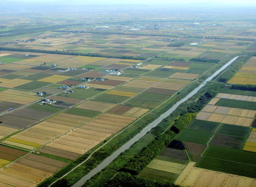
232                                                             M. Yokochi et al.: Subsidence of rice paddy and upland crop fields

                                                                        2     Materials and methods

                                                                        2.1    Reginal settings
                                                                        The investigation of peat subsidence was conducted in
                                                                        Shinotsu Peatland (Fig. 1; 43◦ 150 N, 141◦ 180 E), central
                                                                        Hokkaido, Japan. Its total area is about 12 000 ha, and cur-
                                                                        rently, almost all area has been converted into cultivated land.
                                                                        The mean annual temperature is 7.0◦ , and the mean annual
                                                                        precipitation is 1105 mm with 816 cm of snowfall at Shin-
                                                                        Shinotsu Weather Station of Japan Meteorological Agency.
                                                                        Currently, peat deposited 6 to 7 m thick. The both of bog-
                                                                        type peat and fen-type peat are distributed all over the area,
                                                                        and generally, the fen-type peat is surrounding the bog-type
                                                                        peat.
                                                                           The peatland has been cultivated as multi-use paddy fields
                                                                        (rotational cultivation of paddy rice and upland crop) (Fig. 2),
                                                                        and the main crops in this area are currently paddy rice,
                                                                        wheat, soybean, and vegetables. Initially, the area converted
                                                                        to paddy, but the area that is producing upland crop such
                                                                        as wheat have been increasing under the situation of over-
                                                                        production of rice and the implementation of the set-aside
                                                                        policy by the national government since 1971. In the paddy
                                                                        fields, the ground surface is always saturated with irrigation
Figure 1. Location and extent of the study site and peatland area in
Shinotsu, Hokkaido. The background shaded-relief map is obtained
                                                                        water between middle May and middle August. Both of the
from Geospatial Information Authority of Japan. The distribution of     paddy and the upland fields has drainage ditches and sub-
peat is based on Hokkaido Agricultural Reserch Institution (1954).      surface drainage systems to maintain a suitable groundwater
An inset map in the upper left corner shows the location of the study   table for the crops, so either paddy rice and upland crops can
site within Japan.                                                      be grown by the combination of irrigation and drainage sys-
                                                                        tems.

                                                                        2.2    Subsidence measurement
                                                                        Digital elevation models (DEMs) which constructed by air-
peatlands because the implementation of paludiculture has               borne laser survey were employed for measurement of subsi-
evolved only in recent years.                                           dence. The spatial resolution of the DEMs was 1 m×1 m. The
   In Hokkaido, northern Japan, peatlands have been used as             total subsidence between 2006 and 2016 in each point was
multi-use paddy fields (rotational cultivation of paddy rice            calculated by subtracting the DEM of 2016 from the DEM
and upland crop), one form of palidiculture, for more than              of 2006 using GIS software (QGIS). For each filed plot, the
a half-century. In paddy fields, the groundwater table main-            values of the total subsidence were averaged for the analy-
tains near the ground surface or above during the summer                sis. The DEM of 2006 has an error due to vegetation height
irrigation period, so the subsidence in paddy is expected to            in some field plots, so those plots were excluded from the
slow due to reduction of decomposition of peat substrate.               analysis. We used randomly selected 53 field plots for the
Some studies, indeed, suggested the possibility of the lower            analysis to assess the effect of the land use form (paddy or
rate of peat subsidence in paddy fields compared to upland              upland) on peat subsidence. The 53 filed plots belonged to
fields in Hokkaido (Kasubuchi et al., 1998; Miyaji et al.,              the same township, and the conditions such as the time since
1995), yet the number of observation in those studies was               reclamation and the peat type were not different except the
not sufficient to statistically conclude.                               land use form.
   Here, we present the first quantitative comparison of the
long-term peat subsidence rates between paddy and upland
                                                                        2.3    Reconstruction of the history of land use form
fields in Hokkaido to assess the potential of agricultural use
of wet peatlands as a solution of peat subsidence-related               We reconstructed the land use form of the 53 field plots for
problems. This study will provide an essential suggestion for           each year between 2006 and 2016 to examine the relation-
future land use in Hokkaido and also key knowledge for the              ship between the peat subsidence and the land use form. We
attempt of the paludicultural use of peatlands worldwide as             used satellite images which were taken by the optical sen-
well.                                                                   sor to assess the land use form of each year. The satellite

Proc. IAHS, 382, 231–235, 2020                                                                          proc-iahs.net/382/231/2020/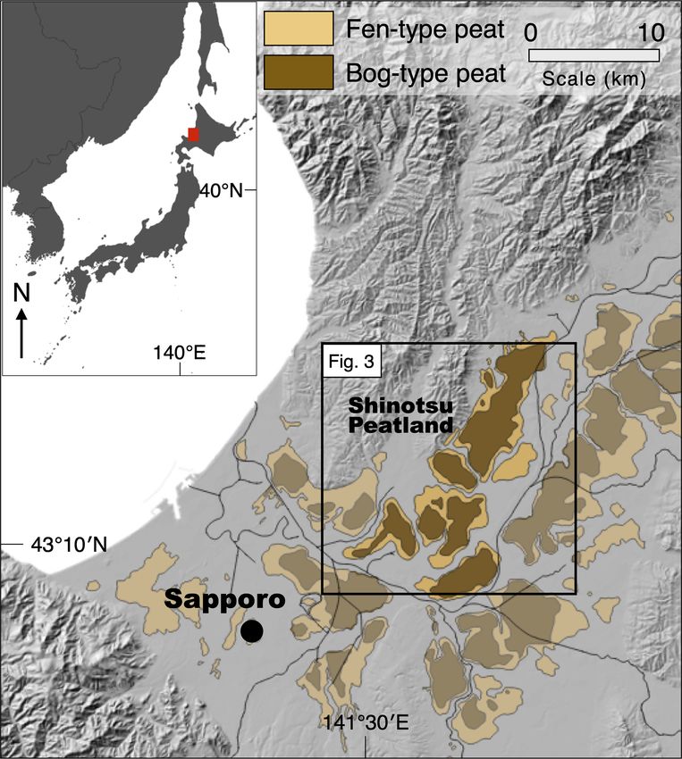
M. Yokochi et al.: Subsidence of rice paddy and upland crop fields 233
Figure 2. An aerial photograph of multi-use cultivated fields with
a canal for irrigation and drainage in Shinotsu Peatland.
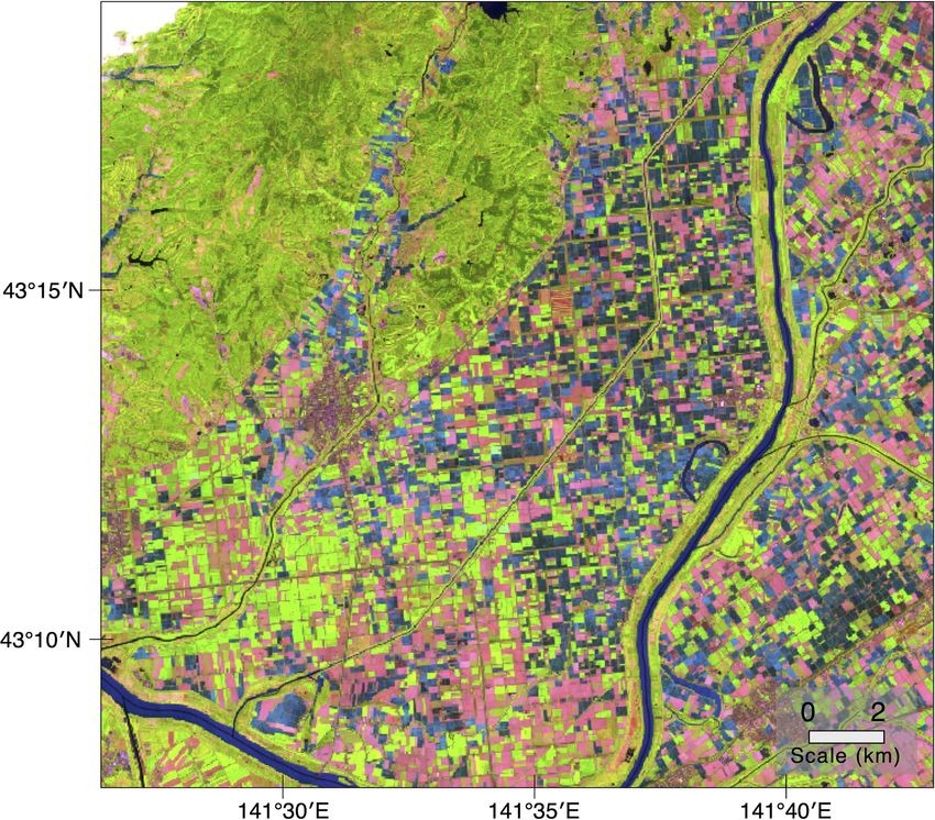
Figure 3. Color composited satellite image of bands of red (R),
included Landsat-5 TM, Landsat-8 TM, and Sentinel-2. We near-infrared (NIR) and short-wave infrared (SWIR), of Sentinel-2
employed the bands of visible red (R), near-infrared (NIR), taken on 28 May 2016 covering Shinotsu Peatland. RGB = (SWIR,
and short-wave infrared (SWIR). The reflection of each band NIR, R). Green area, pink area, and blue area represent upland fields
of the electric wave on the ground surface varies depending with vegetation, upland fields with no vegetation, and paddy fields,
respectively.
on the land cover because each land cover has different spec-
tral reflection characteristic. Water can absorb all bands, so
reflectance of R, NIR and SWIR are generally low. The plant
vegetation highly reflects NIR, but less for R and SWIR. Soil
can highly reflect SWIR, but less for R and NIR. During the
rice transplanting period (May to early June), the paddy fields
are filled by irrigation water whereas the upland fields are
covered by vegetation or bare lands. Based on the land cov-
ered difference, we distinguished the land use forms using
a colour composited image of the R, NIR, and SWIR bands
(Fig. 3). This remote sensing technique is often used in crop
classification (Liu et al., 2005). We reconstructed the land use
form in the 53 field plots between 2006 and 2016, excluding
2007, 2011, and 2012 in which the satellite images were not
available due to cloud cover.
3 Results and Discussion
Figure 4. Relationship between total subsidence from 2006 to 2016
and the years that each field was used as paddy field (out of eight
As a result of the reconstruction of the history of the land use years which the satellite image is available). The error bars rep-
form, 12 field plots out of the 53 plots were used as paddy for resent the standard deviation of the samples. The plots with the
7 years or more between 2006 and 2016 (referred to herein same letter are not significantly different in the Tukey-Kramer test
as the “paddy”), and 15 plots were used as upland fields for (p < 0.05).
7 years or more (“upland”). The rest 26 plots were for rota-
tional use of paddy and upland (“rotation”). In the rotation
plots, rotation of paddy rice and upland crops were generally was used for rice paddy in the same period (excluding 2007,
conducted every 3 or 4 years. 2011, and 2012, in which satellite images were not avail-
The relationship of the peat subsidence to the crop ro- able) (Fig. 4). The mean subsidence was 3.7 ± 1.9 cm (± SE;
tation was examined in 53 fields. The overall mean of the n = 12) for 11 years in the paddy field plots, and significantly
subsidence from 2006 to 2016 in the 53 fields was 15.8 cm, less than the rate of 25.6 ± 1.7 cm (n = 15) in upland field
which equals to 15.8 mm yr−1 . The total subsidence from plots (p < 0.001). In the rotation field plots, the subsidence
2006 to 2016 was plotted against the year which each field was intermediated value between the paddy and the upland
proc-iahs.net/382/231/2020/ Proc. IAHS, 382, 231–235, 2020234 M. Yokochi et al.: Subsidence of rice paddy and upland crop fields
plots, although the difference was not statistically significant as one of the valid options for future peatland management
level (p > 0.05) in the Tukey-Kramer multiple comparisons. in terms of mitigation of land subsidence and peat loss.
Still, it was clear there was a trend that the subsidence re-
duced linearly as the period of paddy increased. This result
suggested that paddy use of peatlands could effectively re- Data availability. The DEM data used in this study were pro-
duce the rate of peat subsidence. vided from Hokkaido Development Bureau. The DEM data are
The total subsidence in the paddy plots was significantly not publicly opened due to national security. The satellite image
smaller than that of the upland field plots. The average sub- data are available from the website of U.S. Geological Survey
(https://landsatlook.usgs.gov, U.S. Geological Survey, 2020). The
sidence rate of 3.7 mmyr−1 in the paddy plots was extremely
processed data of the subsidence for the analysis are available from
low value compared with globally reported values of the peat
the corresponding author, up on reasonable request.
subsidence through agricultural exploitation (Pronger et al.,
2014). Whereas, the average subsidence rate of 25.6 mm yr−1
in the upland plots was well consistent with the globally re- Author contributions. MY and TI developed the overall concept
ported values. These values also showed that the peat sub- and methodology of the study. KS processed the satellite images.
sidence through wet agricultural use was smaller than the MY processed the DEM data and conducted the statistical data anal-
through upland use. ysis. MY prepared the manuscript with contribution from all co-
The possible reason for the reduction of subsidence in the authors.
paddy may have been high groundwater table which inhibits
oxidation of peat substrate. Previous studies have reported
that high groundwater table reduced decomposition of peat Competing interests. The authors declare that they have no con-
substrate (Hendriks et al., 2007; Kim and Verma, 1992). In flict of interest.
the paddy plots, the water table was always maintained above
the ground surface in cultivate period in summer, which kept
the peat layer in anaerobic condition. Although the ground- Special issue statement. This article is part of the special issue
water is drained and lowered from autumn to early spring, “TISOLS: the Tenth International Symposium On Land Subsidence
– living with subsidence”. It is a result of the Tenth International
the temperature is generally low, and much snowfall occurs
Symposium on Land Subsidence, Delft, the Netherlands, 17–21
in those periods without irrigation, which restrains the mi-
May 2021.
crobe activity of the decomposition of the peat. This implies
that the maintenance of wet condition only in the summer
season can sufficiently reduce peat subsidence. Acknowledgements. We express our sincere thanks to Shinotsu
In this study, we just compared the subsidence in the paddy Chuo Land Improvement District (Farmers’ water use association)
and upland fields by measuring elevation change in the spe- and Hokkaido Development Bureau for providing us airborne laser
cific period and did not examine the decomposition rate, the survey data. This study was funded by the Land Improvement Con-
greenhouse gas emission, and their temporal trends. Thus, struction Association of Japan, and we appreciate their grateful sup-
the mechanism of the reduction of the subsidence in the port.
paddy fields has still not been cleared. Additionally, few stud-
ies have reported subsidence on paddy peatland. More stud-
ies on subsidence in paddy fields are required to clarify the Financial support. This research has been sponsored by Land
mechanism and to reinforce our argument. Also, though our Improvement Construction Association of Japan.
results showed the rice paddy has a lower impact on peat
subsidence, the demand and consumption of rice have been
continuously decreasing in Japan. Not only technical imple-
mentations but also political and economic intervention is References
necessary to achieve sustainable land use management on the
peatlands. Gambolati, G., Putti, M., Teatini, P., and Gasparetto Stori, G.: Sub-
sidence due to peat oxidation and impact on drainage infrastruc-
tures in a farmland catchment south of the Venice Lagoon, En-
4 Conclusions viron. Geol., 49, 814–820, https://doi.org/10.1007/s00254-006-
0176-6, 2006.
Gorham, E.: Northern Peatlands: Role in the Carbon Cycle and
We calculated the subsidence rates in different agricultural
Probable Responses to Climatic Warming, Ecol. Appl., 1, 182–
land use form, i.e., rice paddy or upland field. The subsi- 195, https://doi.org/10.2307/1941811, 1991.
dence rate in the rice paddy had significantly lower than that Hendriks, D. M. D., van Huissteden, J., Dolman, A. J., and
in the upland field. This difference suggested that paddy land van der Molen, M. K.: The full greenhouse gas balance
use had a lower impact on peat subsidence. Our results will of an abandoned peat meadow, Biogeosciences, 4, 411–424,
encourage the agricultural use of wet or rewetted peatlands https://doi.org/10.5194/bg-4-411-2007, 2007.
Proc. IAHS, 382, 231–235, 2020 proc-iahs.net/382/231/2020/M. Yokochi et al.: Subsidence of rice paddy and upland crop fields 235 Hokkaido Agricultural Reserch Institution: Soil Texture Report 4, Pronger, J., Schipper, L. A., Hill, R. B., Campbell, D. Soil texture in Ishikari, Sapporo, 1954. I., and McLeod, M.: Subsidence Rates of Drained Agri- Kasubuchi, T., Yoshida, C., Kudo, S., and Miura, K.: Pre- cultural Peatlands in New Zealand and the Relationship vention of peat subsindece in enlarged paddy fields and with Time since Drainage, J. Environ. Qual., 43, 1442, cycle irrigation, Water, land, Environ. Eng., 66, 177–182, https://doi.org/10.2134/jeq2013.12.0505, 2014. doi:https://doi.org/10.11408/jjsidre1965.66.2_177, 1998. Schipper, L. A. and McLeod, M.: Subsidence rates and car- Kim, J. and Verma, S. B.: Soil surface CO2 flux in bon loss in peat soils following conversion to pasture in the a Minnesota peatland, Biogeochemistry, 18, 37–51, Waikato Region, New Zealand, Soil Use Manage., 18, 91–93, https://doi.org/10.1007/BF00000425, 1992. https://doi.org/10.1111/j.1475-2743.2002.tb00225.x, 2006. Leifeld, J., Müller, M., and Fuhrer, J.: Peatland subsidence and U.S. Geological Survey: Landsat image, available at: https:// carbon loss from drained temperate fens, Soil Use Manage., landsatlook.usgs.gov, last access: 5 March 2020. 27, 170–176, https://doi.org/10.1111/j.1475-2743.2011.00327.x, Wösten, J. H., Ismail, A., and van Wijk, A. L. .: Peat 2011. subsidence and its practical implications: a case study in Liu, J., Liu, M., Tian, H., Zhuang, D., Zhang, Z., Zhang, Malaysia, Geoderma, 78, 25–36, https://doi.org/10.1016/S0016- W., Tang, X., and Deng, X.: Spatial and temporal patterns 7061(97)00013-X, 1997. of China’s cropland during 1990–2000: An analysis based Zanello, F., Teatini, P., Putti, M., and Gambolati, G.: Long term on Landsat TM data, Remote Sens. Environ., 98, 442–456, peatland subsidence: Experimental study and modeling scenar- https://doi.org/10.1016/j.rse.2005.08.012, 2005. ios in the Venice coastland, J. Geophys. Res.-Earth, 116, 1–14, Miyaji, N., Kohyama, K., Hiroo, O., and Kasubuchi, T.: Surface https://doi.org/10.1029/2011JF002010, 2011. Subsidenee of Peatland in Bibai, Central Hokkado, Japanese J. Soil Sci. Plant Nutr., 66, 465–473, 1995. Parish, F., Sirin, A., Charman, D., Joosten, H., Minayeva, T., Sil- vius, M., and Stringer, L.: Assessment on Peatlands, Biodiversity and Climate change, available at: http://www.imcg.net/media/ download_gallery/books/assessment_peatland.pdf; (last access: 5 March 2020), 2008. proc-iahs.net/382/231/2020/ Proc. IAHS, 382, 231–235, 2020
You can also read