Subsurface Mapping- A Trenchless Technology Perspective - Geospatial World Forum
←
→
Page content transcription
If your browser does not render page correctly, please read the page content below

Subsurface Mapping-
A Trenchless Technology
            Perspective
                             Geospatial World Forum
                                  19th January 2018
                              HICC, Hyderabad, India

                                    A Presentation by
                                  Dr. Niranjan Swarup
                     Hon. Director (Higher Education)
          Construction Industry Development Council
                                                    &
                                      Director General
            Indian Society for Trenchless Technology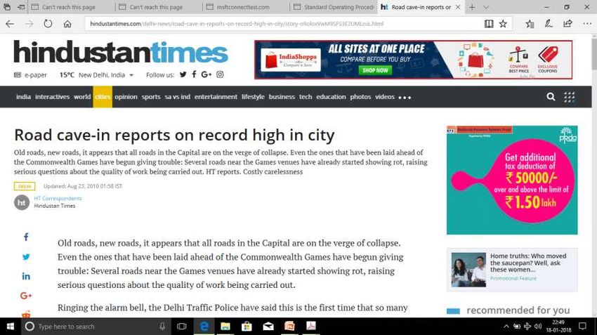
Prologue
Utility System Failure
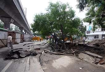
Case 1 – Multiple Road Cave-ins Prior to
2010 Commonwealth Games in New Delhi
New installation work on large scale was
carried out without any prior buried utility
mapping in Delhi.
Following monsoon season saw several road
cave-in incidents in Delhi NCR.
PWD Delhi, engineers initially blamed use of
Trenchless Technology for those collapses.
While, inappropriate use of technology was
the main reason behind those collapses.
Under Delhi PWD assignment, INDSTT
developed the Standard Operating
Procedures for use of Trenchless Technology
on PWD Delhi Roads.
Case 2 – UFW & NRW,
Kerala Water Authority
(KWA)
KWA in 2012-13, conduct a pilot survey of
water mains in the city using a hi-tech
pipeline inspection system.
The insides of the pipes were found to be
heavily tuberculated, which has reduced
their internal diameter and consequently
brought down their carrying capacity by 40%.
An official statistics show that out of the 300
million litres a day (MLD) of drinking water
sent to the pipelines in the city, only 150 MLD
is accounted for.
ALL national ULBs are facing the similar
situation in their respective regions.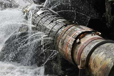
Trenchless Technology
A set of techniques for the
remote installation,                         Microtunneling
rehabilitation and repair of
utilities, pipelines and small
tunnels -- linked by their lack of
need for digging a continuous               Directional Drilling
trench for the installation of new
pipes or the repair of old pipes.

              Installation                  Rehabilitation
              Assessment
             Rehabilitation   Replacement
             Replacement
What will serve our Purpose?

                 OR

Just A MAP?             MAP With Attributes?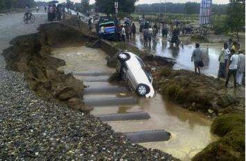
Public Infrastructure
TYPES OF UTILITY In locations where crossings may be required beneath roads the following utilities may be found: Sanitary sewers Surface water/storm drains Combined sewers Water mains Gas mains Gas Distribution pipelines Industrial pipelines Oil transmission pipelines Electricity cables Telephone cables Cable TV cables Street lighting cables Traffic light cables Other data / information technology cables Other unexpected utilities or historic structures.
Standard Operating Procedure
Stipulations Linked with Mapping
       1.  Introduction
       2. Importance
       3. Utility Classification
       4. Location Timing
       5. Scope of Coverage
       6. Responsibility of Location
       7. Sharing of Background Information
       8. Liaising Assistance
       9. Investigation Procedure
       10. Data Management
Data Management Right-of-way owner needs to assume the responsibility of developing, managing and owning the subsurface utility data base. For new structures, as-built drawings and data must be collected from the implementing agencies after proper verification. For existing structures, the use of correct mapping techniques and methods is essential to generate reasonable and correct subsurface interpretations. Professionals engaged in this data generation and interpretation must be adequately skilled in Subsurface Utility Engineering.
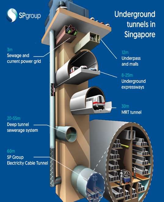
Future of Subsurface Structures

 https://forums.edmw.xyz/threads/deepest-tunnels-in-spore-to-start-carrying-electricity-from-end-2018.64076/
Discussion Paper for Developing Code of
Practice for Subsurface Utility
Engineering Suiting Indian Conditions
                  •Indian Society for Trenchless Technology (INDSTT)
                  in its recently concluded No Dig India Show 2017
                  has released a discussion paper for developing Code
                  of Practice for Subsurface Utility Engineering
                  Suiting Indian Conditions.

                  •Discussion paper is open for the expert comments
                  and interested contributor may contact for the
                  copy of the paper.

                  •Final COP for SUE is schedule to be released in
                  forthcoming No Dig India Show 2018 at Mumbai.
METHODS Pipe and Cable Location Ground penetrating radar (GPR) Terrain Conductivity Resistivity Metal Detection Magnetic Acoustic Thermal/Infrared Gravity Seismic
Principle of GPR

                   GPR
Operator Skills
Concluding Remarks
Buried Utilities pose great challenges as these are out of sight so are out of mind and
we see them only when a failure has occurred.
With each new utility buried, rehabilitated or replaced, the complexity grows and we
need to wakeup to the requirement immediately.
Trenchless is the solution of many of such challenges, provided all subsurface data is
up to date & interpretations are geologically and valid in three dimensions.
We are Vigorously Persuing standardization in subsurface mapping by laying
specifications, competency standards, and operating procedures and invite
stakeholders to join us in this important capacity building initiative.
Associations with this initiative could be through society membership, participation in
the task forces, contribution of technical inputs, vetting and commenting on the draft
documents and proposalsThanks for your attention
Construction Industry Development Council
Indian Society for Trenchless Technology
Hemkunt Chambers, 89, Nehru Place,
New Delhi – 110019
Web: www.cidc.in /www.indstt.com
Mail: cidc@cidc.in /indstt@indstt.comYou can also read