SUCRE: Supporting Users, Controllers and Responders in Emergencies
←
→
Page content transcription
If your browser does not render page correctly, please read the page content below
Ruiz-Zafra et al.                                                       SUCRE: Supporting Participants in Emergencies

 SUCRE: Supporting Users, Controllers
   and Responders in Emergencies
 Ángel Ruiz-Zafra, Ana-Gabriela Núñez, Mª Carmen Penadés, José H. Canós
   MYDASS - LSI                                                ISSI-DSIC
 University of Granada                         Universitat Politècnica de València, Spain
    angelr@ugr.es                       annue1@posgrado.upv.es, {mpenades|jhcanos}@dsic.upv.es

                                               Marcos R. S. Borges
                                                 GRECO - PPGI
                                      Universidade Federal do Rio de Janeiro
                                              mborges@nce.ufrj.br

ABSTRACT
 We use the term “Personal Safety Assistants” (PSAs) to refer to a family of mobile information systems that
intend to reduce the risks of both citizens and responders in emergency responses. Using their mobile devices,
they can access to personalized views of the emergency plans including context-aware evacuation instructions
or real time guidance to specific locations for rescue operations, among others. Additionally, both responders
and citizens act as context sources sending fresh information (e.g. pictures of damaged areas) to the command
and control center, increasing situational awareness. In this paper, we show how the SUCRE infrastructure
collects and processes contextual information to improve the information infrastructure during responses. We
describe the current status of the system and outline the incoming enhancements.

Keywords
Emergency Response, Contextual Information, Citizens, Responders, Web Services.

INTRODUCTION AND MOTIVATION
On December 30, 2006, several calls were received at the emergency services informing about the immediate
explosion of a van loaded with hundreds of kilograms of explosives at the parking area of the Madrid airport.
After checking the authenticity of the calls, an evacuation operation was started following the standard safety
procedures. In a short time, the warnings issued by the airport authorities and emergency responders led to an
apparently total move out of the people from the airport departments to an open and safe area. Unfortunately,
two men were sleeping in their cars with the back of their seats fully reclined, so that they neither heard the
acoustic emergency warnings nor were detected by the policemen that performed the visual inspection of the
empty parking. As a consequence, both men were killed when the 4-floor structure of the parking collapsed after
the explosion of the bomb.
This extreme case illustrates that, despite the preparedness of response teams and their correct application of the
response protocols, some people not related to the emergency response teams –whom we will refer to as
citizens— remained unaware of the emergency situation. Often, the alerting mechanisms work properly, but the
safety information is presented in an almost useless format. A paradigmatic example is the evacuation paths
shown at the back of the doors of hotel rooms: they show a full floor plan in one A4 or A5-size sheet; the
evacuation path is drawn on top of the plan with the aim that guests follow it in case of emergency. If we
consider that this information is supposed to be read in very difficult conditions (lack of electric power, smoke,
etc.), it is obvious that guests’ stress can lead to undesirable panic situations. In fact, panic is usually caused by
lack of appropriate information about how “to escape from” or “to behave in” an emergency situation (Mileti
and Sorensen, 1990).
Traditionally, IT-enabled advances in emergency management systems have focused on improving the
capability of emergency response teams, but important issues such as these mentioned above remain unsolved.
While geographic information systems, sensor networks, and even mobile applications have brought a new
        Proceedings of the 11th International ISCRAM Conference – University Park, Pennsylvania, USA, May 2014
                                    S.R. Hiltz, M.S. Pfaff, L. Plotnick, and P.C. Shih, eds.

                                                                                                                   255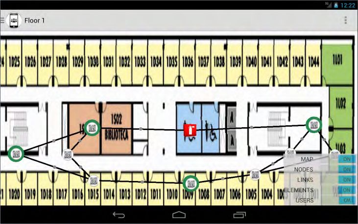
Ruiz-Zafra et al. SUCRE: Supporting Participants in Emergencies
generation of emergency responder support systems, citizens are being supported with old-generation materials.
However, these citizens have embraced enthusiastically technological advances in other fields of their lives,
being the most evident proof of it the myriad of smartphones owned by people. In this scenario, we search for
new solutions that improve the behavior of citizens during emergency situations (Aedo, Yu, Díaz, Acuña and
Onorati, 2012). Improvements can be done in three main aspects, namely safety information, early warning and
guidance in evacuation. Additionally, the mobile devices can send fresh information (e.g. pictures of damaged
areas) to the command and control center, increasing responders’ situational awareness.
In this paper we introduce SUCRE (Supporting Users, Controllers and Responders in Emergencies), an
infrastructure designed and implemented with a twofold goal: first, to help citizens involved in emergency
situations by providing them with context-aware evacuation instructions; and second, supporting emergency
response teams with easy access to emergency context information such as real time guidance to specific
locations for rescue operations, number of people injured in a building, and the alike. Using SUCRE, responders
and citizens act also as context sources, sending information about the emergency in real time.
This paper is organized as follows. Section 2 introduces the SUCRE infrastructure, showing the main services
provided to support the evacuation and rescue tasks. Section 3 describes the main features of the mobile
applications developed. Finally, Section 4 concludes the paper and outlines our future work.
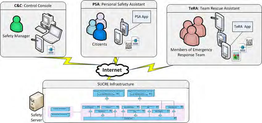
THE SUCRE INFRASTRUCTURE
SUCRE has been developed following the Service Oriented Architecture (SOA) paradigm based on REST
(Fielding, 2000). It provides a set of information services which can be consumed by other applications during
an emergency through open standards such as XML. Fig. 1 shows the main components of the infrastructure: (i)
The Building component provides information about the infrastructure such as maps, number of floors, location
of emergency equipment like fire extinguishers, etc. (ii) The Evacuation component calculates the route from
two different places in the building; its initial purpose was to drive citizens to safe places, but its behavior is the
same in case of calculating entry routes. (iii) The Client component obtains information about citizens (for
instance their health profile), which users are safe and which are still in the building, and their location. (iv) The
RescueTeam component obtains information about the members of the emergency response teams which are
inside the building. In the current SUCRE version, location is provided by taking pictures of QR codes with the
users’ mobile devices (see section 3); however, the services provided by the SUCRE components are valid for
any other location mechanism. Other elements of the SUCRE infrastructure are: (iv) the Emergency component
used to declare the start/end of an emergency situation; (v) the Messages component (to send/receive messages
to/from target groups or users), and (vi) the Log component (to record all the events produced during an
emergency for its post-mortem analysis). Currently, SUCRE generates notifications for mobile devices on the
iOS and Android platforms.
Figure 1. Architecture of the SUCRE Infrastructure
When an emergency is activated, the participants must receive the evacuation instructions as soon as possible. In
this case, the response time of the services provided by SUCRE infrastructure is crucial to ensure the
evacuation. For this purpose, SUCRE uses a NoSQL database (Stonebraker, 2010) to store the information of
the organizational building as a graph model. This model is able to generate the shortest path between two
different points (for instance, the shortest path between where the citizen is located and the nearest emergency
exit) in less time than using a relational database (Batra and Tyagin, 2012); improving response time, the
probability of the successful evacuation of potential victims is increased. Additionally, a relational database is
used to store the remaining information, such as all the information generated in an emergency context, personal
Proceedings of the 11th International ISCRAM Conference – University Park, Pennsylvania, USA, May 2014
S.R. Hiltz, M.S. Pfaff, L. Plotnick, and P.C. Shih, eds.
256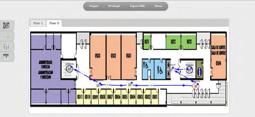
Ruiz-Zafra et al.                                                      SUCRE: Supporting Participants in Emergencies

information about the participants, log, and messages, among others.

Modelling evacuation paths as graphs
The Building component is used to create graph representations of the evacuation paths of buildings, and works
for both single and multi-floor infrastructures. At a given floor, several reference points are established and
associated to specific location identifiers (QR codes in the current version). The floor is modelled as a directed
graph, whose nodes are the reference points, and an edge from a point p1 to p2 means that a part of an
evacuation path exists between those points. For each edge, two values are defined: its cost (measured in terms
of distance, difficulty, or any other criteria) and the evacuation instructions (typically provided as descriptive
text like “walk until the next fire extinguisher and then turn right”). For evacuation purposes, there must be one
or more distinguished nodes in a graph representing safe places where evacuation paths should lead to. Fig. 2
shows a screenshot of the modelling application. To ease the modelling task, the graph can be built on top of an
image of the floor to be modelled. Graph nodes correspond to the QR codes placed in the appropriate locations
in the building. In case of multi-floor buildings, a separate tab is included for each floor being modelled. The
connection between floors must be modelled, too. The building models created are stored in a graph database
that is used by the Evacuation component to calculate evacuation routes from specific locations in a building.

            Figure 2. Screenshot of the Building component: graph representation of the evacuation routes

Calculating evacuation routes and entry routes
The Evacuation component exploits the models stored in the graph database to calculate evacuation paths upon
request. Taking a location (i.e., a given graph node) as input, this module finds the best evacuation route using
the Floyd-Warshall algorithm (Floyd, 1962), which calculates minimal paths in directed and weighted graphs.
The evacuation route proposed is then the minimal path from the location to any of the safe places. The
computational cost of the calculation procedure is O(N3), but the matrix is only calculated when the emergency
is activated (the system is initialized), or when an edge is inaccessible (this contextual information is provided
by a participant). The computational cost to each request for evacuation is O(N) when the system is running.
Building graph models can also be used to guide members of emergency response teams to specific locations
within a building. This is the case of a wounded victim that needs urgent help and was last located near a given
reference point, which is taken by the algorithm as the target point. The procedure is the same as the case of
evacuations.

Managing context
The context gathered during an emergency is managed by the Log component. There is a database where all the
interactions between the mobile devices and the server are recorded. Specifically, a new record is added to the
log every time an event happens. The information recorded from each event basically is the user identifier, the
operation, a description, and the safety server identifier. Examples of events are: a citizen signals any type of
emergency, a citizen requests an evacuation route from a location, a member of emergency response team
requests information about an area of the building, a member of emergency response team accesses to the health
profile of a victim, etc.
        Proceedings of the 11th International ISCRAM Conference – University Park, Pennsylvania, USA, May 2014
                                    S.R. Hiltz, M.S. Pfaff, L. Plotnick, and P.C. Shih, eds.

                                                                                                                 257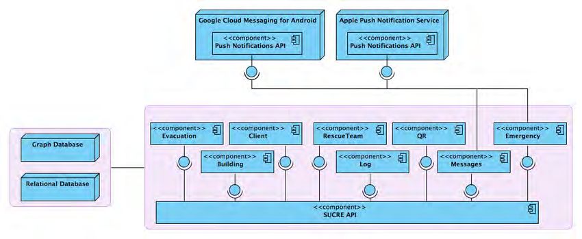
Ruiz-Zafra et al.                                                      SUCRE: Supporting Participants in Emergencies

SUPPORTING THE DIFFERENT PARTICIPANTS
Different participants are involved in an emergency: citizens as potential victims, emergency response teams
and command and control units (Kurki and Sihvonen, 2012). The current SUCRE version provides support to
both citizens as potential victims and emergency response team by means of two mobile applications (see Fig.
3). Additionally, support to Command & Control staff is provided via a desktop application that will be
complemented with a mobile application in further versions of the system. The following describes their main
features.

                           Figure 3. Participants supported in the SUCRE Infrastructure.

Supporting Command and Control: the Control Console (C&C)
The safety manager uses the C&C to manage the overall system. The C&C displays the contextual information
during an emergency; specifically, the participant locations (victims and responders) and the inaccessible
reference points (nodes) in the routes. Other functionalities provided are related to modelling of the building
and the evacuation path as graphs using the application showed in Fig. 2, and, the calculation of evacuation
routes for citizens and entry routes for members of the emergency response teams. Further versions will include
utilities for sending and receiving messages, consulting the emergency plan or other external information
sources, system administration facilities, as well as incident tracking and control.

Supporting victims: the Personal Safety Assistant (PSA)
Traditionally, citizens have not been included as emergency participants, being only relevant as potential
victims. In SUCRE, however, they play a very relevant role both as consumers and producers of contextual
information during the response: their mobile devices act as mediators between them and the members of the
emergency response teams which try getting situational awareness before deciding a particular rescue action.
Fig. 4a shows screenshots of the PSA application for the Android platform. First, a citizen location is sent, and
second, the evacuation instructions are received in the device. If the citizen finds an obstacle and the evacuation
instructions are invalid, then the citizen requests a new evacuation route, which is calculated in real time. The
status of all the routes is maintained permanently thanks to the information received from the citizens’ and
responders’ devices. When a notification is received about difficulties to traverse some path, its cost is changed
to infinity in the model, so the algorithm will not generate routes through it.

Supporting responders: the Team Rescue Assistant (TeRA)
The emergency response teams play a key role in the emergency management systems. They have a specific
training to rescue tasks and care for victims; however, their experience and knowledge can be improved with
contextual information about the emergency. For instance, where the potential victims (citizens) are located,
what is their health profile, what is the entry route to the victims, which obstacles (if any) are in the route,
request a new entry route, send their locations, send a rescue request in case of problems, etc. The mobile
application is able to get contextual information hosted in the SUCRE infrastructure to guide the members of the
emergency response team toward the potential victims. A screenshot of the TeRA application for Android
platform is shown in Fig. 4b. When the emergency response team identifies the emergency activated in the
TeRA application, the SUCRE infrastructure provides all the information (building maps, nodes and elements
for each floor, etc) and the location of the citizens who are registered on each floor and their profile (for
        Proceedings of the 11th International ISCRAM Conference – University Park, Pennsylvania, USA, May 2014
                                    S.R. Hiltz, M.S. Pfaff, L. Plotnick, and P.C. Shih, eds.

                                                                                                                 258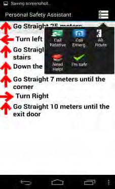
Ruiz-Zafra et al.                                                      SUCRE: Supporting Participants in Emergencies

instance, the green circle in a node indicates 0-5 citizens). Different symbols and colors are used to represent the
information. For calculating an entry route, the member of the emergency response team must select a node on
the map (the target node), and then, the TeRA application shows the path to the victim. We are collaborating
with the Fire Department in Valencia, and they have participated in the design of the TeRA application (in the
requirements phase).

             (a) PSA Application                                 (b) TeRA Application
           Figure 4. Screenshots of the Personal Safety Assistant (PSA) and Team Rescue Assistant (TeRA)

CURRENT STATUS AND FURTHER WORK
 SUCRE is an infrastructure providing context management facilities to other emergency management and
response applications. The API services are currently available at http://psasrv.dsic.upv.es:8080/Sucre/api/.
Prototypes of the mobile clients can be downloaded on request. SUCRE is a system in rapid evolution, and as
SOA-based solution, is able to support new services (Mahmood, 2007). We are working in the improvement of
the existing tools, as well as in adding new features to the different components. Of particular interest is the
development of mobile clients for platforms other than Android. We are collaborating with the Fire Department
in Valencia to perform some tests of the TeRA tool in some incoming drills. These tests will be the first step of
a number of usability and scalability tests we intend to perform along this year.

ACKNOWLEDGMENTS
We thank H. Rus Hernández from the Fire Department of Valencia (Spain) for their cooperation in the design
and validation of TeRA Application. The work of J.H. Canós and M.C. Penadés is partially funded by the
Spanish MEC under grant TIPEx (TIN2010-19859-C03-03). The work of A.G. Núñez is partially supported by
the Ecuadorian SENESCYT and IECE.

REFERENCES
1.   Aedo, I., Yu, S., Díaz, P., Acuña, P. and Onorati, T. (2012) Personalized Alert Notifications and Evacuation
     Routes in Indoor Environments. Sensors 2012, 12, 7804-7827; doi: 10.3390/s120607804
2.   Batra, S. and Tyagi, C. (2012). Comparative analysis of relational and graph databases. International
     Journal of Soft Computing and Engineering (IJSCE), 2(2).
3.   Fielding, R. (2000) Architectural Styles and the Design of Network-based Software Architectures,
     Dissertation. University of California, Irvine.
4.   Floyd, R. W. (1962) Algorithm 97: Shortest Path, Communications of the ACM 5(6): 345. doi:
     10.1145/367766.368168.
5.   Kurki, T.A. and Sihvonen, H. (2012). A Role-Based Resource Management Approach for Emergency
     Organizations. In System Science (HICSS), 45th Hawaii International Conference, pp. 3679-3687. IEEE
6.   Mahmood, Z. (2007). The promise and limitations of service oriented architecture. International Journal of
     Computers, 1(3), 74-78.
7.   Mileti, D.S. and Sorensen, J.H. (1990). Communication of emergency public warnings: A social science
     perspective and state of the art assessment. Oak Ridge National Laboratory Rep. ORNL-6609.
8.   Stonebraker, M. (2010) SQL databases v. NoSQL databases. Communications of the ACM 53 (4): 10-11.
     doi: 10.1145/1721654.1721659
        Proceedings of the 11th International ISCRAM Conference – University Park, Pennsylvania, USA, May 2014
                                    S.R. Hiltz, M.S. Pfaff, L. Plotnick, and P.C. Shih, eds.

                                                                                                                 259
You can also read