Super Sites for Education in Sunrise Track/Swamp Track
←
→
Page content transcription
If your browser does not render page correctly, please read the page content below
Super Sites for Education in
Sunrise Track/Swamp Track
Ruahine Conservation Park
Resource Kit for Teachers

Author: Elizabeth Pishief, Department of Conservation, Gisborne

Published by
East Coast Hawke's Bay Conservancy
Department of Conservation
Gisborne
New Zealand
June 2002
Printed on recycled paper

Super Sites for Education in Sunrise / Swamp Track, Ruahine Conservation Park   5
Published by
    East Coast Hawke's Bay Conservancy
    Department of Conservation
    PO Box 668
    63 Carnarvon Street
    Gisborne
    New Zealand
    ISBN 0-478-22281-5
    CROWN COPYRIGHT RESERVE

6   Super Sites for Education in Sunrise / Swamp Track, Ruahine Conservation Park
CONTENTS

1      Using this Resource                                                      5
        1.1     Using this Resource                                             5
        1.2     Cross-Curricular or Specialised                                 5
        1.3     Activities                                                      5
                1.3.1 Pre and Post Visit Activities                             6
                    1.3.1.1 Pre-Visit Activities                                6
                    1.3.1.2 Post-Visit Activities                               7

2      Organisation and Facilities                                              8
        2.1     Organisation of Outdoor Safety                                  8
        2.2     Sunrise/Swamp Track Facilities                                  8

3      Sunrise and Swamp Tracks                                                 10
        3.1     History                                                         10
                3.1.1 Maori History                                             10
                3.1.2 Pakeha History                                            11
        3.2     Uses of Sunrise/Swamp Track                                     12
        3.3     Conservation and Current Issues                                 12
        3.4     Threats                                                         12
        3.5     Management of Ruahine Conservation Park                         12

4      Teachers’ Background Reading                                             14
        4.1     Ruahine Conservation Park                                       14
        4.2     Biodiversity                                                    15
        4.3     Geology/Soils/Erosion                                           15
        4.4     The Visit to Swamp/Sunrise Tracks                               15
        4.5     Plant Identification                                            16
        4.6     Changes in vegetation with altitude                             17

5      Statements about Curriculum Links and the Kits                           18
        5.1     Socia Studies                                                   18
                5.1.1 Social Organisation                                       18
                5.1.2 Culture and Heritage                                      18
                5.1.3 Place and Environment                                     18
                5.1.4 Time, Continuity and Change                               19
                5.1.5 Resources and Economic Activities                         19
        5.2     Science                                                         19
                5.2.1 Living World                                              19
                5.2.2 Planet Earth                                              20
        5.3     Technology                                                      20
        5.4     Health and Physical Education                                   21
                5.4.1 Personal Health and Physical Development                  21
                5.4.2 Movement Concepts and Motor Skills                        21
                5.4.3 Relationships with other People                           21
                5.4.4 Healthy Communities and Environments                      21

Super Sites for Education in Sunrise / Swamp Track, Ruahine Conservation Park   7
6 General Study Topics 22
6.1 Signage 22
6.2 Toilets 22
6.3 Track structures 22
6.4 Weeds 22
7 Teacher Study Sheets 23
7.1 Socia Studies 23
7.2 Audio and Visual Arts 24
7.3 Earth Science 25
7.4 Microclimate Project 26
7.5 Microclimate Study Sheet 27
7.6 Microclimate Activity 27
7.7 Changing Microclimate Conditions Within a Forest 28
8 Monitoring 29
8.1 Forest Monitoring Study Sheet 30
8.1.1 Kohekohe 30
8.1.2 Tawa 30
8.1.3 Rewarewa 31
8.2 Fruit Classes 31
8.3 Foliar Browse Index Sheet 31
8.4 Insect v Possum damaged leaves 33
8.5 Foliage Cover Scale 34
8.6 Field Recording Sheet 35
9 Other References and Resources 37
10 Super Sites for Education Resource Kit Evaluation Form 38
8 Super Sites for Education in Sunrise / Swamp Track, Ruahine Conservation Park1 Using this Resource
1.1 USING THIS RESOURCE
This Teacher Resource Kit is designed to give you a hand to plan exciting
and educational conservation learning experiences outside the
classroom. It focuses on a selection of parks and reserves administered
by the Department of Conservation (DOC) in your region.
There are thirteen accessible sites within East Coast Hawke’s Bay that are ideal for
learning about marine reserves, mainland islands, forests, endangered species and
historic reserves. By visiting these sites students can consolidate work already done
and gain additional first-hand experiences and information to complete their studies.
1.2 CROSS-CURRICULAR OR SPECIALISED
In planning your programme we suggest using the Guidelines for Environmental
Education in New Zealand Schools. The guidelines provide advice on
environmental topics and how to plan these into curriculum studies and programmes
with a bicultural focus.
Sites can be used to meet goals from specific curriculum areas, or different curriculum
areas simultaneously. This is an approach that mirrors the interconnectedness of the
environment.
1.3 ACTIVITIES
Activities in these kits can be adapted to the age/level of your students, allowing you to
choose the achievement objectives at the appropriate level. Activities are designed to
support the key dimensions of environmental education – in, about and for the
environment.
The activities offer students the opportunity of working across a range of related
subject areas – in much the same way as the project teams work together to manage a
mainland island or marine reserve, for the benefit of all. Teachers are encouraged to
undertake further extension activities such as:
• Use of media such as the internet, books, videos, maps and tapes.
• Taking part in a Ministry of Education LEOTC (Learning Experiences Outside the
Classroom) programme.
• Visits to zoos, aquaria, botanic gardens, museums, marine education centres and
other facilities offering environmental education programmes and resources.
• Guided trips and recreational activities led by accredited outdoor education
providers.
Super Sites for Education in Sunrise / Swamp Track, Ruahine Conservation Park 91.3.1 Pre and Post Visit Activities
To get the best value from a field trip teachers should plan good lead-in and follow-up
activities. If students have some formative ideas about what they might find, they will
observe in a more focused way and therefore develop their concepts more fully. The
suggested activities given below are designed to encompass learning ‘about’ and ‘for’
the environment. You will find specific site-based activities for Sunrise/Swamp Track
(learning ‘in’ the environment) from page 14 onwards.
1.3.1.1 Pre-Visit Activities
• Brainstorm the ideas that students already have about Sunrise/Swamp track for
example What is a forest? What would you expect to find living in a forest? Can you
think of any forests you have visited? (about)
• Design and carry out an opinion poll. What different attitudes do people have
about forests and their protection? Is there a range of views? What are the
implications of your findings? (for)
• Have a class debate on why the forest ecosystem at Ruahine Forest Park should be
protected and saved. Explore concepts such as attitudes and values. (for)
• Examine the meanings of the words ‘endangered’, ‘exotic’, ‘endemic’, ‘indigenous’
and ‘native’. Think about what plant and animal species might be found at Sunrise/
Swamp track and where they fit into the above categories. (about)
• Consider the impact of exotic plants and animal species on the forest. Why is their
management necessary? Design a campaign to raise awareness about pests and
weeds and their impact on forest ecosystems. (for)
• Find out what the students know about DOC. Why does DOC exist? Is there a DOC
office in your area? What sort of things does a DOC ranger do? Check out the DOC
website, www.doc.govt.nz (about and for)
• Look at what your class can do to help the environment – while visiting Sunrise/
Swamp Track and back at school. Why is this important? How can your school’s
local community get involved in protecting natural areas? (for)
• Explore New Zealand’s responsibilities under global conventions such as the
Convention on Biodiversity and the Kyoto Convention. Use the DOC website to find
out about the New Zealand Biodiversity Strategy. Why is this strategy necessary?
How do the goals and actions in the strategy relate to Sunrise/Swamp Track?
(about and for)
• Find out who the local hapu are for Sunrise/Swamp track. Where is their marae?
Who are the kaumatua? What stories can they tell you about Sunrise/Swamp Track
and the Ruahine Range? How can traditional knowledge of the Ruahine Range and
its use be more widely available to people who visit the area? Design ways of
distributing information, such as interpretation panels, brochures, web pages and
radio interviews. What will your message be? Why? (for)
• Visiting outdoor areas usually requires special gear and there are safety issues to
take into account. Have students list the clothing and other gear they think they will
need on the trip and create new designs. (about)
• Design an outdoor safety code. Appoint class members to help apply it on the day.
Why is this important? (about)
10 Super Sites for Education in Sunrise / Swamp Track, Ruahine Conservation Park1.3.1.2 Post-Visit Activities
• Make a forest display along a wall of your classroom with teams working on tree
trunks and foliage, shrubs, lianes and epiphytes. Add pictures or models of birds.
Make silhouettes of birds in flight to adorn the ceiling. (about) Why is it important
to protect and save these species? What can you do to protect an ecosystem?
(for)
• Draw plants and animals that make a food chain and /or cut them out. Arrange
them into a food chain, or, for more advanced students, build up a food web. What
happens when you introduce an animal pest (herbivore or predator) into the
equation? (about)
• Choose a picture of a bird like the ruru/morepork and identify its special features
e.g. nocturnal eyes with third eyelid, grasping clawed toes, acute hearing, soft
feather tips. Add labels for these adaptations (features) and say how each helps the
bird survive. Why are many of our native species vulnerable to introduced
predators? What can we do to help protect them? (about and for)
• Make a “wanted” poster for an introduced mammal pest. Describe the damage that
the pest is doing and suggest an ecological reward for its elimination. (for)
• Calculate the weight of forest that possums destroy in New Zealand. There are
about 70 million of them and they can eat between 0.8 and 1 kg per night. Work it
out per night and per year. The consider the effects in their favourite food species
and on the other native plant eaters. How can we keep the possum numbers down?
(about)
• Find out about three weeds that have established in the Ruahine Forest Park. Why
are these plants weeds? How did they come into New Zealand? How could they get
into Ruahine Forest (for example look at human dispersal of weeds). What plants
in your garden at home could potentially become weeds in a forest ecosystem?
(Look at fast growing species, climbers, method of seed dispersal, etc.) Why
should you be careful about disposing of garden rubbish? (about and for)
• Find out about the use of plants as rongoa or traditional medicines. Ask your local
kaumatua or check books in the library. Try some tea made from kawakawa
leaves. (about)
Get your school involved:
• Adopt a local reserve.
• Join a community conservation group.
• Plant a native garden
• Use plants that will encourage native birds to your school.
• Raise funds for a threatened species.
• Get involved with the Kiwi Conservation Corps (Forest & Bird) or Junior
Naturalists.
For more information on how your school can get involved in
conservation contact your local DOC office.
Super Sites for Education in Sunrise / Swamp Track, Ruahine Conservation Park 112 Organisation and Facilities
2.1 ORGANISATION OF OUTDOOR SAFETY
When planning a visit to Sunrise/Swamp Track, follow school policy to make sure the
correct procedures are being followed. For example you will need to do a risk analysis
and management plan for your visit.
Points to Remember:
• Be sure to brief students on outdoor safety before the visit, and remind them
again, on arrival, to take care. Students are to stay together at all times and under
no circumstances are they to wander off by themselves.
• Have parents/helpers well briefed on their responsibilities – the main one is to
know exactly where their charges are at all times.
• The study sites are along, or close to main tracks and the possibility of getting lost
is minimal.
For further in-depth information on outdoor safety refer to:
• Education Outside the Classroom Guidelines for Good Practice.
Ministry of Education, 1995.
• Managing Risks in Outdoor Activities. Mountain Safety Manual 27, 1993.
• Outdoor Safety Management Systems. EONZ, 1998.
• Outdoor Pursuits Guidelines for Educators. Hillary Commission, 1996.
• Water Safety Across the Curriculum. Water Safety New Zealand, 2000.
These publications are available in school or from your local EONZ branch.
2.2 SUNRISE/SWAMP TRACK FACILITIES
Swamp Track and Sunrise Tracks can both be accessed from either the Triplex
Carpark or the Swamp Track carpark.
• Swamp Track is a low level track which leads through a mixture of beech, rimu and
kahikatea forest. The loop takes an hour to complete and is also accessible from
the Triplex carpark and from Sunrise Track
• The track to Sunrise Hut starts about 50m before the Triplex Hut. This is a high
standard graded walk which gives easy access to the open tops of the Ruahine
Range. It is one of the Park’s most popular tracks and is suitable for family and
school groups.
Triplex Hut to Sunrise Hut takes between 2-3 hours.
• Toilets
• Shelter
There is shelter at Triplex and Sunrise Huts
12 Super Sites for Education in Sunrise / Swamp Track, Ruahine Conservation Park• Onga Onga Field Centre,
Main Street
PO Box 78
ONGAONGA
Telephone/fax (06) 8566808
• A pre-trip visit to the site by the trip leader is recommended to enable the best
organisation for the class/es on the day.
• Do not disturb traps, poison stations and other equipment.
Super Sites for Education in Sunrise / Swamp Track, Ruahine Conservation Park 133 Sunrise and Swamp Tracks
Sunrise and Swamp tracks are situated on the eastern flank of the Ruahine range about
2 hours drive southwest of Napier. The Ruahine Conservation Park was gazetted in
1976 and covers an area of 94,000 hectares. It includes the main Ruahine Range plus
four subsidiary ranges, the Ngamoko, Whanahuia, Hikurangi and Mokai-Patea Ranges.
The Park runs north from the Manawatu Gorge, for approximately 100 km to the
Taruarau and Ngaruroro rivers which form the boundary between the Ruahine and
Kaweka Conservation Parks. The eastern area rises abruptly from the Ruataniwha
Plains and the rolling hills of the Blackburn Range.
The basic vegetation pattern consists of forest rising to 950-1350m, above which it is
replaced by subalpine shrubland sometimes extending to 1430m. Alpine grasslands
and herbfields may range from 1100m to the summit crests.
The lower altitude forests in this area are generally a mix of podocarps, rimu, miro and
matai, and tawhai (red beech). Smaller trees and shrubs such as horopito, rangiora,
and mahoe, together with ferns, and tataramoa (bush lawyer) grow in the understorey.
In swampy areas are many of the same plants, but kahikatea dominate. The forests on
the higher slopes are composed almost entirely of mountain beech trees.
The natural erosion of this region has been accelerated by burning and deer and
possum browsing.
3.1 HISTORY
3.1.1 Maori History
Maori explored the Ruahine Ranges and visited them for hunting, fishing, plant
collection and other purposes. As yet no archaeological sites of early Maori origin have
been recorded in the Park although a number of sites have been recorded in its
surrounds.
The tribes associated with the Ruahine Range are Ngati Kahungunu, Ngai Tahu, Ngati
Apa and Rangitane and the many hapu included in these tribes, particularly Ngai te
Upokoiri and Hinemanu.
Ruahine Conservation Park was occasionally used for refuge. According to tradition,
in the 1600s Whatui Apiti, a chief of Rangitane and Kahungunu, descent fled to the
mountains west of Takapua after some trouble and built a pa there where he stayed for
several months. War parties (taua) crossed the Ruahine. When William Colenso was
planning his first attempt in 1845 he was warned by the local chiefs that the routes
were dangerous and many people had lost their lives there. The only person he could
find who had been across had done so first as a captive and later as a refugee.
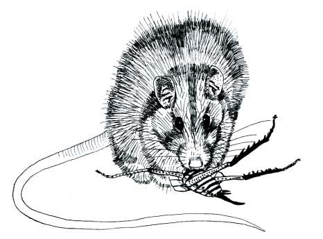
Food was gathered from the Ruahine. It is recorded that the beech forests of the
mountains were the habitat of the Maori rat (kiore) and every hapu had its own area
where no other group could hunt the kiore, which was a great delicacy.
Two ancient tracks have been recorded. The first crossed the Range above the
Manawatu Gorge at Ahua-o-Turanga and thence on to Rangitikei or south to Otaki.
14 Super Sites for Education in Sunrise / Swamp Track, Ruahine Conservation ParkThe second one was used by Colenso when he made the first European crossing in 1845. It followed up the Waipawa and Makaroro river crossed the range at Te Atua o Mahuru and then went over Mokai Patea to the Rangitikei River. Maori names for features in the Park such as the rivers, mountains and valleys indicate the close association Maori had with the Ranges. The name of the Park itself Ruahine means “the wise woman”. Te Aue Davis says the Range was named after the daughter of Turanga I Mua and Parehuia. Turanga I Mua was the son of Turi, the captain of the Aotea canoe (one of the canoes of the Fleet). 3.1.2 Pakeha History Some of the earliest European records were made by the Missionary William Colenso who was also an explorer and botanist. He made the first collection of New Zealand alpine plant species during his expedition in 1845. Large scale forest clearance took place in the foothills beginning in the late 1880s. A milling operation was based at Makaroro River from the 1920s for 25 years. The Gardner and Yeoman Mill was located at the present Makaroro River carpark. A timber mill also operated from near the end of North Block Road from 1930-1942. Farming with cattle and sheep took place from the 1880s. Early runholders stocked merino sheep in the Ranges. The track connecting Mangaohane with Poporangi was the main mustering route. Old huts such as Shutes and Ellis established to accommodate shepherds and rabbiters are a reminder of Pakeha use of the Ranges. Red deer and possums have probably had the most pronounced effect on the vegetation of the Park over the last century. Red deer first appeared on the northwestern ranges between 1890 and 1900 probably from the Matapiro liberation of 1883. Deer numbers peaked in the 1930s and the government started controlling their numbers in 1938 when foot shooting by deer cullers began. Operations intensified in the 1960s under the New Zealand Forest Service when the network of tracks and huts were established which are now the basis of the recreational facilities used by present- day park users. The development of a commercial market for feral venison in the late 1960s attracted many hunters to the hills. Now deer numbers have dropped by about 90%. Possums were first liberated to create a fur industry. The first liberation was in the Pohangina valley in thee 1890s and by the 1920s several liberations had been made on both sides of the Range. Breeding populations soon became established and by the 1950s possums were present in very high numbers. The effects of possums on forests soon became apparent and trapping was encouraged to reduce the numbers. Armstrong Saddle was named after the pilot Hamish Armstrong who crashed on to the saddle in 1935 in very misty conditions. The plane was only found after several weeks although Armstrong himself was never found. A shirt labelled “XXX” was the only clue found to his whereabouts and the stream and hut Triplex take their name from it. This crash showed the need for an organised tramping club with an efficient search and rescue team in Hawke’s Bay and the result was the formation of the Heretaunga Tramping Club. Super Sites for Education in Sunrise / Swamp Track, Ruahine Conservation Park 15
3.2   USES OF SUNRISE/SWAMP TRACK

           • Walking and tramping
           • Hunting
           • Education
           • Biodiversity monitoring and restoration.
           • Scientific research.

     3.3   CONSERVATION AND CURRENT ISSUES

           The complexity of the topography and vegetation provides excellent habitat for native
           wildlife. A wide variety of bird species is found in the Ruahine Conservation Park.
           Rare or threatened species include the Blue duck, New Zealand Falcon, North Island
           Kaka, the Long-tailed cuckoo and the North Island Robin as well as Powelliphanta
           snails.
           A banding and monitoring programme has been established to monitor the Blue Duck
           population.
           There have been reports of native bats in the Park. Common species of skinks and
           geckos have been recorded in the Ruahine Ecological district. The Park abounds with
           native invertebrates. The native fish Galaxius spp., and eels are present in most of the
           major river systems. Torrent fish have been identified in some of the rivers on the
           eastern side of the Park.

     3.4   THREATS

           Threats to the native flora and fauna include:
           • Grazing and browsing by deer, goats, pigs, sheep, cattle, rabbits, hares and
             possums.
           • Weed infestations.
           • Predators – stoats, ferrets, weasels, hedgehogs, cats, stray dogs, rats and mice.
           • Fire.

     3.5   MANAGEMENT OF RUAHINE CONSERVATION
           PARK

           Management by the Department of Conservation includes:
           • Extermination of wild animals.
           • Control of weeds.
           • Monitoring of forest health.
           • Scientific research.

16         Super Sites for Education in Sunrise / Swamp Track, Ruahine Conservation Park
• Maintaining and upgrading recreational facilities
• Providing interpretation and publications.
Management Objectives of the Department of Conservation:
• To protect and retain indigenous ecosystems, species and habitats – including
ENVIRONMENTAL native birds and lowland forest.
CARE CODE • To encourage and facilitate recreational use and appreciation of the natural
Protect plants and resources of the area.
animals
Remove rubbish
Bury toilet waste
Keep streams and
lakes clean
Take care with fire
Camp carefully
Keep to the track
Consider others
Respect our cultural
heritage
Enjoy your visit
Toitu te whenua
(Leave the land
undisturbed)
Super Sites for Education in Sunrise / Swamp Track, Ruahine Conservation Park 174 Teachers’ Background
Reading
4.1 RUAHINE CONSERVATION PARK
Gondwanaland and the evolution of New Zealand’s flora and fauna.
New Zealand’s geological and geomorphological history began in the Precambrian era
which ended 570 million years ago. New Zealand’s ancestral land mass was once part
of Gondwanaland, the super-continent which included Australia South America and
India and was close to Asia. Gondwanaland slowly rotated until it drifted close to
Antarctica in the Southern Hemisphere and contact was lost with Asia.
By the Triassic and Jurassic periods (between 135-208 million years ago) New Zealand
had rotated away from the South Pole to warmer mid-latitudes and the land links
enabled a large number of the Gondwanaland plants and animals to move into New
Zealand, including the ancestors of many of our native and endemic flora and fauna –
the kauri, podocarps, ferns, tuataras, insects, native frogs, moas and kiwis.
In the Cretaceous period (95-110 million years ago) eastern and western
Gondwanaland split and New Zealand was again close to Antarctica. Various animals
and flowering plants used Antarctica as a stepping stone to move from South America
into Australia and New Zealand. The flowering plants included the ancestors of beech
trees (Nothofagus) and other species represented today by horopito, tawa, kawakawa
and rewarewa.
The Tasman Sea opened up about 60-80 million years ago which left the ancient
Gondwanaland biota - podocarps, tuataras, moas and kiwis – as the endemic flora and
fauna. Later arrivals had to float or fly across the oceans, or get here by relying on
human transportation, accompanying Maori and European settlement. Animals that
successfully colonised New Zealand after the oceans opened up included New Zealand
wrens and thrushes, the wattlebirds and the New Zealand bat.
The evolution and spread of mammals occurred much later than the birds and
flowering plants and was prevented by the formation of the Tasman Sea so mammals
did not dominate New Zealand until the arrival of humans. Because of its isolation New
Zealand has retained one of the best assemblages of Gondwanaland life to be found.
Our podocarp forests contain more species with ancient lineages than most forests
elsewhere in the world, with the ancestry of some species stretching back 190 million
years or more. Our unique frogs, earthworms, carnivorous snails, insects, spiders and
many other creatures have ancient lineages virtually unknown any where else.
New Zealand’s biota is even more special because it has evolved without the influence
of mammals and major predators. However since the arrival of humans and the
introduction of predators many of the existing flora and fauna have been unable to
survive the modification of the environment. Some species have become extinct and
others are now endangered. The concept of Mainland Islands is an attempt to halt the
path to extinction for remaining species and to restore the forests to how they were
before the impact of human settlement.
18 Super Sites for Education in Sunrise / Swamp Track, Ruahine Conservation Park4.2 BIODIVERSITY
New Zealand’s biodiversity is distinct in the world because our native animals and
plants have evolved in isolation over 80 million years. We boast the world’s only
flightless parrot (kakapo), a bird with nostrils at the end of its beak (kiwi) a frog which
bears live young (Leiopelma species) and the giant weta, a large insect which fills the
role played by mice and other small rodents in other countries, as well as many other
exceptional species.
High numbers of New Zealand’s indigenous species are endemic, that is, they are not
found any where else in the world.
New Zealand has one of the worst records of biodiversity loss in the world. Human
actions including destruction of forests, wetlands and coastal areas for farming have
already led to the extinction of a quarter of New Zealand’s land and freshwater birds,
three out of seven frogs, at least 12 invertebrates such as snails and insects, one species
of fish, one of bats and possibly 11 species of plants.
Today about 1000 of our known animal, plant and fungi species are considered
threatened. This is the forerunner to species extinction.
4.3 GEOLOGY/SOILS/EROSION
Geologically the Ruahine Range is very young and it is being uplifted very rapidly
(approximately 4mm per year). It is considered to be between 1 to 2 million years old.
Its greywacke rocks are shattered and contain many faults. The two most active are
the Ruahine and Mohaka faults. Both lie mainly east of the divide. The consequence is
very unstable terrain down which the rivers fall in very steep grades to the Hawke’s Bay
Plains.
Most of the park consists of shattered greywacke, but limestone, sandstone and
siltstone are found in the northwest of the Park.
The soils are generally strongly leached shallow steepland soils from greywacke and
may contain volcanic ash and loess deposits.
The physical structure of the Ruahine ranges – steep, unstable landforms, many
faultlines and skeletal soils – combined with high rainfall, frequent cyclonic events and
strong winds results in high natural erosion.
Fires, the clearing of native vegetation and browsing animals have contributed to the
natural processes, although Grant suggests the erosion is a natural process which has
been occurring in cycles. The erosion cycles appear to coincide with general climatic
warming. The present trend began about 1950 and is known as the Waipawa erosion
period.
4.4 THE VISIT TO SWAMP/SUNRISE TRACKS
Both Swamp Track and Sunrise Track are particularly suited to school visits.
During the walk the students will be able to:
• smell, hear, see and feel the differences between the bush and school/town.
Super Sites for Education in Sunrise / Swamp Track, Ruahine Conservation Park 19• identify the different forest types,
• hear and see a number of bird species,
• look out across the bush in the valleys to the surrounding farmland which
surrounds the Ruahine Conservation Park,
• find bait stations,
• examine exclosure plots,
• look under the leaves,
• discover endangered mistletoe,
Forests are usually distinguished by the dominant canopy forming trees. A variety of
vegetation types is found in the Ruahine Conservation Park, influenced by altitude,
rainfall, snowfall, exposure to wind and temperature.
Several pre- and post-visit viewings of The Ancient Forests of New Zealand
(Learning Media, Ministry of Education) will enhance understanding of forest
ecosystems.
4.5 PLANT IDENTIFICATION
A visit to Sunrise/Swamp tracks will be more interesting if you are able to
recognise some of the following plants:
Rimu
Miro
Matai
Totara
Horopito
Mahoe
Rangiora
Toetoe
Red Tussock
Leatherwood
Red beech
Mountain beech
Kahikatea
20 Super Sites for Education in Sunrise / Swamp Track, Ruahine Conservation Park4.6 CHANGES IN VEGETATION WITH ALTITUDE
Super Sites for Education in Sunrise / Swamp Track, Ruahine Conservation Park 215 Statements about Curriculum
Links and the Kits
Because this kit is site-based and most kit users will visit the site, the main curriculum
objectives will be based around an environmental theme.
The strongest links will probably be with the science, social studies and health
and physical education documents, although aspects of the technology and the
art curriculums are important in getting the best value from a visit.
Of course the English document is always the basis of any study as the other
documents continually feed in material that develops students’ learning in oral, written
and visual language. Similarly, good opportunities exist at all sites to explore many
ideas in all of the mathematics strands. The best summary of links for the seven
curriculum areas can be found in: Ministry of Education, 1999. Guidelines for
Environmental Education in New Zealand Schools. Ministry of
Education, Wellington, New Zealand.
5.1 SOCIAL STUDIES
Social Studies Education aims to enable students to participate in a
changing society as informed, confident and responsible students.
Ruahine Conservation Park visits and projects offer opportunities for students,
at appropriate levels, to develop concepts in each of the five strands. Examples
for each of the five strands are listed below:
5.1.1 Social Organisation
• how people organise themselves to visit the Park,
• what type of groups of people they are,
• how groups organise themselves to respond to management issues,
• how DoC organises staff to manage the Ruahine Conservation Park.
5.1.2 Culture and Heritage
• aspects of Maori tradition associated with the Ruahine Range,
• the use of the Park by family, tramping, community and educational groups,
• the Ruahine Conservation Park as a significant landmark and landscape feature.
5.1.3 Place and Environment
• why the Ruahine Conservation Park is a significant environment for people,
• how peoples’ activities influence the Ruahine Conservation Park environment,
• how and why peoples’ perceptions of the Ruahine Conservation Park are
reinforced or changed by information or experience,
22 Super Sites for Education in Sunrise / Swamp Track, Ruahine Conservation Park• how and why people seek to resolve differences over how places and environments
should be used,
• how people express a sense of belonging to the Park,
• the importance of the place and environment for recreation.
5.1.4 Time, Continuity and Change
• how past management decisions changed the nature of the Park.
• how beliefs and ideas in society change and how this has impact on the Park
• how the process of change over time is used as a tool for Park management
• how Maori use of the Ruahine Conservation Park has changed over the centuries.
5.1.5 Resources and Economic Activities
• how Maori used the area as a resource in the past
• the European use of the Park – farming, sawmilling.
5.2 SCIENCE
Learning in science is fundamental to understanding the world in which we live and
work. It helps people clarify ideas, to ask questions, to test explanations through
measurement and observation and to use their findings to establish the worth of an
idea. (Science in the New Zealand Curriculum, p. 7.)
Of the four contextual strands: the living world, the physical world, the material world
and planet earth and beyond, Ruahine Conservation Park studies will particularly
enhance development of knowledge, understanding, skills and attitudes in the living
world and planet earth strands.
5.2.1 Living World
Development of concepts in all of the four achievement aims (Science Curriculum,
p. 52) could be attained during a Ruahine Conservation Park project with the first
three aims culminating in an enhanced understanding of the all important Aim Four.
This can be achieved through appropriate activities at any level from one to eight.
Native Forests:
• What are the living and non-living things that make up a forest.
• Design nutrient and water cycles.
• Identify native trees – concentrating on leaf shapes and patterns.
• Introduce Ruahine Conservation Park vegetation maps. Why are particular species
found in specific localities or habitats?
Birds:
• Identify bird calls.
• Videos:
– Black Robin - Wild South
– Song of Protection Kokako - Wild South
Super Sites for Education in Sunrise / Swamp Track, Ruahine Conservation Park 23– Night Parrot/ Projection Takahe (48 minutes) – Wild South
– Kiwi (54 minutes) – Wild South
– Kiwi recognition (7 minutes) - DoC
• Cassette tape - New Zealand Songbirds.
Invertebrates
• Design a key to identify insects and spiders.
• Design a trap to catch some insects. Trial it at school.
• Video – Spineless Wonders (15 minutes).
5.2.2 Planet Earth
Achievements in Aims One and Two (Science Curriculum, p. 106) lead to achievement
of Aim Four: investigate how people’s decisions and activities change the physical
environment and develop a responsibility for the guardianship of the planet and its
resources. Any achievement in this aim through studies at Sunrise/Swamp tracks is
probably the most important of the entire New Zealand Curriculum Framework.
Research Biodiversity to develop children’s understanding of why New Zealand’s
native plants and animals are unique. Emphasis is placed on Gondwanaland, the
separation of the super-continent and the influence this has had on the evolution of
New Zealand’s biota.
Videos: We Have It All (except snakes) – 8 minutes
Biodiversity in Aotearoa – Greenpeace.
Interpretation of the extensive views of the surrounding landscape, however
elementary, from the vantage points can help to cement important ‘our land, our
place, our guardianship’ values and attitudes in students of all ages.
Investigations of the aims and objectives of the management plans for Ruahine
Conservation Park will give important insights into the environmental guardianship
role given to the Department of Conservation by government policy.
5.3 TECHNOLOGY
Learning in technology implies becoming confident in using a variety of
means to address needs and opportunities and solve practical problems
within society.
Technology education explores choice and the factors which influence choice,
including culture and society, costs and benefits, aesthetics and fitness for purpose.
It seeks to empower students to make informed choices in the use of technology and in
their response to technological change. (Technology in the New Zealand
Curriculum, p. 8.)
A wide range of opportunities exist through a visit to Sunrise/Swamp
tracks within the context of three strands:
1. Technological Knowledge and Understanding.
2. Technological Capability.
24 Super Sites for Education in Sunrise / Swamp Track, Ruahine Conservation Park3. Technology and Society.
Examples would include the technologies involved in:
• Animal, plant and pest monitoring and control at Ruahine Conservation Park
• The development of facilities for visitors such as:
- tracks
- track structures
- signage
- toilets
- shelters
- vehicle access
• Aspects of the school trip to Ruahine Conservation Park such as choices of:
- clothing
- food
- drink
- personal accessories.
5.4 HEALTH AND PHYSICAL EDUCATION
Ruahine Conservation Park visits and projects offer opportunities for students, at
appropriate levels, to develop concepts in each of the four strands. For example:
5.4.1 Personal Health and Physical Development
• Identify sand use safe practices and risk management in the Park environment.
• Share ideas and beliefs about how the use of the Park environment enhances a
person’s health.
5.4.2 Movement Concepts and Motor Skills
• All achievement objectives in this strand could be met through the development of
concepts relating to safe and efficient tramping skills in a group situation.
5.4.3 Relationships with other People
• Development of skills relating to planning safe and enjoyable experiences at
Ruahine Conservation Park with class or family groups.
• Develop skills in relating to other group members while at Ruahine Conservation
Park – to maximise enjoyment and positive learning experience outcomes.
5.4.4 Healthy Communities and Environments
• Share ideas to identify factors that relate to reserve use and community mental and
physical health.
• Identify concepts that are used in the management of the Park environment that
enhance the wellbeing of the plants and animals (ecosystem).
Super Sites for Education in Sunrise / Swamp Track, Ruahine Conservation Park 256 General Study Topics
6.1 SIGNAGE
Both technology and social studies projects could study the design and construction of
sign messages about conservation.
6.2 TOILETS
Applicable to both technology and social studies projects. For example a project
could be developed on the ‘evolution’ of the long-drop. Why are today’s versions more
‘user friendly’?
6.3 TRACK STRUCTURES
Topics student could look at include:
• The design of:
- Tracks,
- Shelters,
- Gates,
- Steps,
- Bridges.
• The needs of visitors versus the impacts of visitors.
• Costs of maintenance.
6.4 WEEDS
The control of weeds is an important management goal. Common weeds include:
- Gorse,
- Thistles,
- Ragwort,
- Grasses.
• Look for different weed types.
• Identify the weeds.
• Draw different weeds.
• Suggest methods of eradicating weeds.
26 Super Sites for Education in Sunrise / Swamp Track, Ruahine Conservation Park7 Teacher Study Sheets
7.1 SOCIAL STUDIES
Debating
During discussions about the place that the Department of Conservation has in
preserving our natural and historic heritage students will realise that people hold
different opinions on that role.
Encourage them to talk to their families, parents, friends etc. to find out what they
consider should be done.
Use the media – for example TV, the newspaper (the free local edition, or the
Education page in newspapers) magazines (if your school subscribes.
Use Web pages for information or write to organisations that are involved in
environmental issues, such as Forest and Bird, Federated Farmers or the New Zealand
Historic Places Trust.
Find out about Resource Consents.
These findings can then be used to form debates on issues such as :
• Should more Conservation Parks or National parks be created?
• How should pests be controlled?
• Should people pay to use the Park?
• Who should make decisions about management of the Park?
• If oil or minerals were found in Ruahine Conservation Park – should it be extracted
or mined?
Role playing could cover the same issues.
Surveys
The issues raised in the debating topics could be used to develop surveys to find out
other peoples’ views.
• Surveys could be developed using criteria such as:
- Age,
- Gender,
- Culture.
• Collate information as graphs, percentages, etc.
• Results could be presented :
- in the school newspaper,
- at assembly,
- on the local newspaper, or
- shared with other schools.
Super Sites for Education in Sunrise / Swamp Track, Ruahine Conservation Park 277.2 AUDIO AND VISUAL ARTS
This worksheet is designed to give you ideas you can develop with students of any age
group. The suggestions may be developed individually or could become a major,
integrated unit of work, linking many curriculum areas.
Music
The bush provides a wonderful symphony of sound. This could be taken back to the
classroom, either by using a tape recorder, and/or having sound on of the objectives
students focus on during the visit. For example:
• Identify and note down the different sounds heard (in what form students record
this is to be discussed before the visit.)
• Record these sounds in written form.
• Take a tape recorder and record as many different sounds as possible.
• Elect groups to study specific areas, e.g.
- Natural – air, water, land.
- ‘Man-made’ – air, water, land.
Back at school
• Discuss the different sounds heard and recorded.
• Record as many sounds as possible in written form to produce a score of music.
• Using voices and music produce a piece of music that represents the “Voices of
Ruahine Conservation Park”.
Plays
The forest also portrays never-ending activities by the creatures in their habitat. These
provide wonderful opportunities for students to develop their imagination. If you
choose this concept, before your visit, you will need to prepare students to observe
closely all the activities on site. These could then be the objectives on which to base
your unit.
• Observe and record the movements and areas creatures are seen and how they
move.
• Record the creatures responses to their environment. What would their response
be if you could understand their language?
• Discuss the effect people have on their environment.
Back at school
• Collate this information into a play for presentation e.g. at school assembly.
• portray the characters using costumes, masks etc.
Art
To develop an understanding of Ruahine Conservation Park, students’ attention needs
to be directed towards the colour, texture and form of the environment.
28 Super Sites for Education in Sunrise / Swamp Track, Ruahine Conservation Park• Feeling the different textures and recording (using crayon and newspaper)
- Bark
- Vegetation
- Stones
- Undergrowth
- Leaves.
• Observe the colours – above, around and below – a camera will help record.
• Look at the form of trees, plants, birds, fish, animals, water and the landscape.
Back at school
• Develop the above points individually using a variety of media and discuss the need
to look and record them individually.
• When developing form use pencil/charcoal sketching as a starting point.
• Combine the three elements of colour, form and texture to produce a picture. This
can be developed with multimedia and as a group activity.
7.3 EARTH SCIENCE
In conjunction with visits to the Ruahine Conservation Park, the children will be able to
discover the natural processes and forces involved in forming the landscape. A variety
of projects can be developed depending on the site visited, but much can be done pre
and post-visit e.g.
• Discover the meanings of these geological terms, giving a brief description of each
one:
earthquake fault line sedimentary
igneous metamorphic thrust
fold anticline syncline
sandstone mudstone limestone
tephra pumice conglomerate
dip angle volcanic tectonic
• Discuss and record the processes involved in forming the Hawke’s Bay landscape.
• Estimate the geological age of Hawke’s Bay.
• Predict the forces that are at work forming the Ruahine Range.
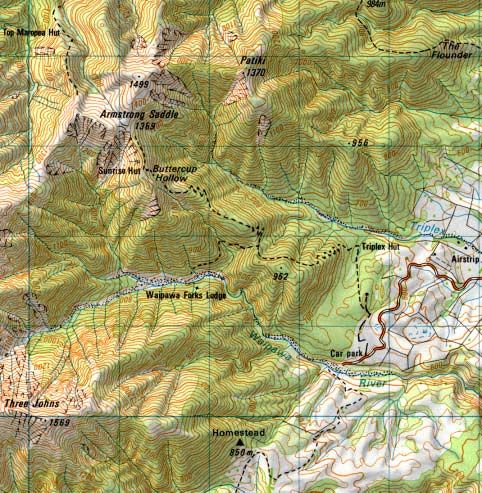
• Refer to the topographical map U21 Kereru and U22 Ongaonga. Find the Ruahine
Range, Sunrise Hut, Swamp track. Identify cliffs, gorges and fault lines in the area.
In what direction is the land uplifting and sloping?
• Develop a device to measure the dip angle of the hills.
Field trip
• Identify the significant areas of geological importance on the visit to Ruahine
Conservation Park
• Find evidence of other major geological events in the area e.g. folding, thrusting.
• Measure the dip angle of the hills and record your results.
Super Sites for Education in Sunrise / Swamp Track, Ruahine Conservation Park 29• What evidence of erosion can you find? Identify the causes and suggest ways of
halting this problem. Write a report on your findings when you return to class.
• Identify various geological events within the soil strata.
7.4 MICROCLIMATE PROJECT
In managing a forest it is important to keep the condition of the edge as stable as
possible so that the different climate conditions on the outside do not penetrate too far
into the interior and disturb the fragile nature of the forest ecosystem.
Researchers have found that light intensity, wind speed and temperature vary along a
gradient from immediately outside the forest to about 80m into the interior of a forest.
Key findings from such studies are listed below:
• At a point 80m into the forest from the edge, light available for photosynthesis was
only c. 0.7% and wind speed c. 20% of that in the open.
• The gradient was less steep for wind speed and air temperature, with at least 40m
being required to stabilise these variables when wind was blowing directly into the
forest.
• These findings suggest that forest edge buffer zones of at least 40m may be needed
to protect forest reserves and streams from climatic exposure.
• There are at least five variables, which together characterise the microclimate:
- Sunlight exposure.
- Wind exposure.
- Precipitation.
- Temperature (of air and soil).
- Moisture content (of air and soil).
• The research suggested that contrasts between forest and pasture conditions are
most marked in the early afternoon.
• There is also a higher species richness at the edge than in the interior and a shift in
composition towards high light ‘pioneer’ plants similar to those found in treefall
gaps in the interior.
• The growth of plants near the edge in response to the high light exposure has
tended to seal the edge, creating an ‘edge canopy.’
• Climbers, notably rata and lawyer seem to be particularly important in the edge
canopy formation.
Microclimate contrasts – forest versus pasture.
• The near floor environment of the forest is very much shadier, much less windy and
fluctuates less markedly through the day in temperature and moisture than in the
open.
• The forest is cooler and more moist during the day and, to a lesser extent, warmer
and drier at night than pasture environments.
• Gradients of microclimate are of greatest significance on sunny and windy days.
30 Super Sites for Education in Sunrise / Swamp Track, Ruahine Conservation ParkImplications
• The edge effects on microclimate extend at least 40m into the native New Zealand
rain forests. This has implications for both conservation of the interior forest
environments and for riparian buffers to protect streams.
• Forest buffers of 40m wide may be needed on both sides of small streams to protect
riparian ecology where the surrounding land use is open pasture or crop land.
7.5 MICROCLIMATE STUDY SHEET
The objective of these activities is to investigate changing climatic conditions outside
and inside the forest. Students should be encouraged to think about what effects the
difference can have on forest health. Students can check their own findings and may be
able to come up with some interesting ideas of their own by trying the procedures
detailed below.
Remember that time spent on preparation at school will ensure better
results in the field.
Equipment
• Wind strength measures (anemometers)
These can be obtained from the weather kits that the Advisory Service lend to
schools
Or – try making some! (See Making Sense of Planet Earth and Beyond pp.77-
8.)
• Thermometers for temperature.
These can also be found in the weather kits.
• Light level measures (this is a harder one.)
Try just judging the light using a scale, e.g. Bright – high – medium – low - dim
Use a camera with a light meter and record readings facing towards the brightest
light.
Someone may have a proper light meter. If they lend it be very careful with it.
• Tape measure
Take the longest one the school has – even two.
This is laid out in a line from a point 5m on the open side of the forest edge to at
least 40m into the forest interior.
• Recording sheet.
Design your own recording sheet at school.
7.6 MICROCLIMATE ACTIVITY
• It is best to do this activity in the early afternoon – at the end of lunch when the
group is all together.
• Choose a suitable site.
• Start 5m from the forest edge, run the tape at a right angle to the edge of the forest
and straight into the interior – of course you may have to step around trees.
Super Sites for Education in Sunrise / Swamp Track, Ruahine Conservation Park 31• Record the light level, temperature and wind strength at the beginning point, 5m or
so inside the edge and then at regular intervals along the tape or line. You may
choose to do 10m or 20m intervals.
• Work in a team with one person recording the findings at each spot.
Back at school
• Decide how the data can be presented and analysed. A graph something like the
one below may be the choice, together with written summaries.
• Discuss why there are microclimate differences and what effect this can have on
forest health.
7.7 CHANGING MICROCLIMATE CONDITIONS
WITHIN A FOREST
32 Super Sites for Education in Sunrise / Swamp Track, Ruahine Conservation Park8 Monitoring
This section covers the measurement of ecosystem recovery and the monitoring of
species outcome, which indicate the success of pest control.
The forest ecosystem involves interactions between many different components.
Different parts of the ecosystem and interactions between them, can be used as
indicators of ecosystem health.
When forest scientists and managers check on forest health over a period of time they
find out if the forest is improving, is stable or is declining in overall health.
This is called forest monitoring.
Monitoring and protection of vegetation has been established to record forest recovery
as well as to ensure the viability of threatened plant populations. Vegetation
monitoring include:
- mapping of vegetation patterns,
- assessing changes in 20 x 20m permanent plots,
- photopoints,
- monitoring of threatened species populations.
• Vegetation plots
- Measure the composition, diversity and density of vegetation in 20 x 20m plots
- Do a rapid assessment of Ecological areas (forest health).
If you intend to use this activity contact Ongaonga Field Base who will be
able to tell you the best place for the activity to be carried out.
Bird monitoring provides a measure of the changes in the bird community over time
in response to predator control.
The methods used include:
- Five-minute bird count,
- Vantage Point Kereru count.
Birds
Tui
Kereru
Miromiro (Tit)
Piwakawaka (Fantail)
Korimako (Bellbird)
Riroriro (Grey warbler)
Kakariki
New Zealand Falcon
North Island Kaka
Whio (Blue Duck) are found in the headwaters of the Makaroro River.
Lizard Monitoring is achieved by the use of:
- Pit fall traps,
- Searches – by day and night,
- Lizard houses.
Super Sites for Education in Sunrise / Swamp Track, Ruahine Conservation Park 338.1 FOREST MONITORING STUDY SHEET
For the purposes of this exercise several monitoring techniques can be tried. The
methods given are not as precise as those used by scientists, however they provide
good practice models.
Forest monitoring can be done on the. The Foliar Browse Index Sheet, examples of
insect and possum damaged leaves, tawa fruit damage and Foliar Cover Scale are given
pp. 31 - 34.
For back at school for and about the environment activities refer to the front section.
8.1.1 Kohekohe
This tree is favourite possum food! Possums eat both the leaves and the flowers of
kohekohe. Some trees are so badly affected by possum browsing that twigs and
branches begin to die.
We will assess:
• Dieback – how much of the canopy shows dead branches and twigs.
• Foliage Cover – use the 10 point foliage cover scale – this tells how thick the
canopy leaf cover is.
• Browse – the proportion of possum damaged leaves. Possum damage shows
leaves bitten in half, sometimes with the midrib intact. See the diagram on p. 33
showing the differences between insect damage and possum damage.
• Stem use – look for scratch (claws) and bite marks on the trunk and large
branches.
8.1.2 Tawa
You can use the list below to make judgements about the study tree. The flowering
and fruiting times for tawa are:
• Flowering – September to December
• Fruiting – October to February
On the Foliar Browse Index Sheet p. 31 use the information for:
- foliage cover:
- dieback
- browse
- stem use
- flowering
- fruiting
Use this with your score sheet as a guide when assessing the tree.
High scores for dieback, stem use and browse together with low scores for flowering
and fruiting means the tree has been badly affected by possum activity and damage.
Examples of possum and insect damaged leaves of kamahi, and tawa are given on p.
33.
34 Super Sites for Education in Sunrise / Swamp Track, Ruahine Conservation Park8.1.3 Rewarewa
Assess them for flowers and look for insect damage. Binoculars may be needed.
8.2 FRUIT CLASSES
Fruits found at the respective sites may be divided into the following fruit classes
Immature: Predominately green, hard, not ripe.
Ripe: Well-coloured and soft. Tawa fruit will be purple/black and Hinau fruit will
be purplish in colour.
Withered/dry: Flesh has gone and husk is dry and brown/black
Possum damaged: Tawa – the whole outer skin is removed. Often the husk has the centre
cleanly scooped out.
Rat damaged: Many ragged edges with signs of small teeth marks. Often part of the kernel
remains. Rats tend to attack ripe fruit on the ground.
Insect damaged: Generally one or more small entry holes about the size of a pencil lead. Inner
kernel is eaten out.
Rotten: Mature fruit is soft and rotten when squeezed and does not contain insect
entry holes.
8.3 FOLIAR BROWSE INDEX SHEET
Foliage Cover
From the Foliage Cover Scale p. 34 select the square which most closely resembles
the foliage cover of the canopy.
Dieback
The conspicuous presence of dead branches or branchlets over the whole of the
canopy. Record dieback as:
0 No dieback affecting 75% of the canopy.
Super Sites for Education in Sunrise / Swamp Track, Ruahine Conservation Park 35Browse
The proportion of possum-browsed leaves (or in the case of small-leafed species such
as totara, the severity of possum-related hedging*) averaged over the whole canopy.
0 Nil No browsed leaves or no possum-related
hedging.
1 Light 5-25% browsed or lightly hedged.
2 Moderate 26-50% browsed or moderately hedged.
3 Heavy 51-75% browsed or heavily hedged.
4 Severe 76-100% browsed or severely hedged.
* Trees showing signs of possum-induced hedging will have little of the
current season’s growth remaining.
Use
Recent possum use of the lower 2m of the trunk or stem. Record as:
0 Nil No scratching or bite marks on the trunk
1 Light Occasional scratch and bite marks.
2 Moderate Numerous clearly defined scratch and bite marks.
3 Heavy Bark worn smooth, evidence of well developed
possum ‘run’.
Flowering and Fruiting
Look for the presence of flowers and fruit.
36 Super Sites for Education in Sunrise / Swamp Track, Ruahine Conservation Park8.4 INSECT V POSSUM DAMAGED LEAVES
Super Sites for Education in Sunrise / Swamp Track, Ruahine Conservation Park 378.5 FOLIAGE COVER SCALE 38 Super Sites for Education in Sunrise / Swamp Track, Ruahine Conservation Park
8.6   FIELD RECORDING SHEET

      Attach to Clipboard
      Name      _______________________________________ Date: ________________
      Location      __________________________________________________________

      Which trees are you studying?
      (Name and Number)

      Foliar Browse Index:
                                          Tree 1                    Tree 2                  Tree 3
      • Foliage Cover               _____________               ____________             ____________
      • Dieback                       _____________             ____________             ____________
      • Browse                      _____________                ____________            ____________
      • Stem use                    _____________                ____________            ____________

      Foliage Cover Scale
      Write down the percentage cover for your study trees.
      Tree 1 ____________ Tree 2________________ Tree 3 _____________

      Flowering/Fruiting
      Tick the following for fruit and flowers:
                                                       Fruit                             Flowers
      • 0 = none                                 ______________                       _______________
      • 1 = rare                                 ______________                       _______________
      • 2 = occasional                           ______________                       _______________
      • 3 = common                               ______________                       _______________
      • 4 = abundant                             ______________                       _______________
      • 5 = very abundant                        ______________                       _______________

      Make a note on fruit classes found and rat or possum damage from fruit observed on
      the ground.

      Super Sites for Education in Sunrise / Swamp Track, Ruahine Conservation Park                  39
You can also read