Supplemental Norfolk Harbor Navigation Improvements Project - Thimble Shoal Channel, Chesapeake Bay Bridge Tunnel - Protective Rock Blanket ...
←
→
Page content transcription
If your browser does not render page correctly, please read the page content below
Supplemental Norfolk Harbor Navigation
Improvements Project – Thimble Shoal Channel,
  Chesapeake Bay Bridge Tunnel – Protective
           Rock Blanket Project

              Virginia Beach, Virginia

                 Appendix E:
      Essential Fish Habitat Assessment

                      January 2021

       Prepared By:
       U.S. Army Corps of Engineers
       Operations Branch
       803 Front Street
       Norfolk, Virginia 23510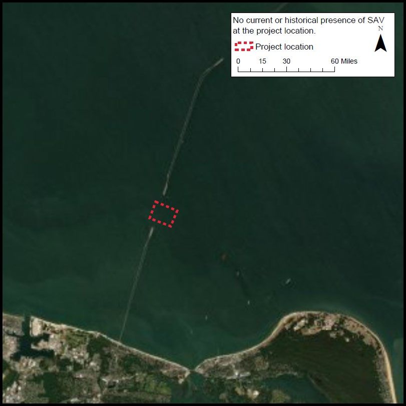
DEPARTMENT OF THE ARMY
                                  US ARMY CORPS OF ENGINEERS
                                       NORFOLK DISTRICT
                                        FORT NORFOLK
       Reply to                        803 FRONT STREET
       Attention of                  NORFOLK VA 23510-1011

                                 January 28, 2021

Operations Branch

Mr. David O’Brien
National Oceanic and Atmospheric Administration
National Marine Fisheries Service
P.O. Box 1346
1370 Greate Road
Gloucester Point, Virginia 23062

Re: Request for Essential Fish Habitat Consultation Pursuant to the Magnuson-
Stevens Fishery Conservation and Management Act, for the Supplemental Norfolk
Harbor Navigation Improvements Project – Thimble Shoal Channel, Chesapeake
Bay Bridge Tunnel (CBBT) – Protective Rock Blanket (PRB) Project, Virginia
Beach, Virginia

Dear Mr. O’Brien:

The U.S. Army Corps of Engineers, Norfolk District (USACE) is requesting to initiate
Essential Fish Habitat (EFH) consultation with the National Oceanographic and
Atmospheric Administration, National Marine Fisheries Service (NMFS) pursuant to
Section 305(b)(2) of the Manguson-Stevens Fishery Conservation and Management Act
and in accordance with 50 Code of Federal Regulations 600.06 – 600.930. The Act
requires an EFH consultation for an action or proposed action authorized, funded, or
undertaken by a Federal agency that may adversely affect EFH.

The scope of the consultation is to coordinate the updated means and methods for the
Norfolk Harbor Navigation Improvements Project – Thimble Shoal Channel, CBBT –
PRB Project, Virginia Beach, Virginia. The updated scope of the Supplemental CBBT –
PRB Project consists of the following actions:
   • Construction of a water injection dredging (WID) trench east of the CBBT - PRB
       site, via conventional dredging (i.e. clamshell bucket and/or hopper) to a
       maximum depth of -70 feet (ft) mean lower low water (MLLW), 1,200 ft long and
       525 ft wide, removing approximately 250,000 cubic yards;
   • Transport and placement of suitable WID trench material at the Dam Neck
       Ocean Disposal Site;
   • Water injection dredging of the existing CBBT cover material to -61 ft MLLW of
       an area that is 150 ft wide by 1,200 ft long;
   • Dredged material placement of the CBBT cover material through WID methods
       into the WID trench.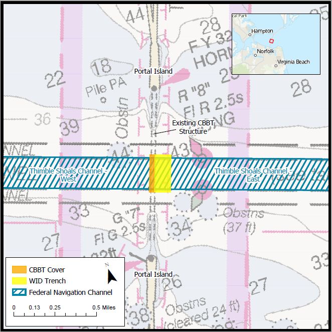
Attached for your review is the Chesapeake Bay Bridge Tunnel – Protective Rock
Blanket Essential Fish Habitat Assessment with the EFH anticipated to occur and
potential effects to EFH within the Region of Influence. USACE made the preliminary
determination that the implementation of the updated CBBT-PRB scope may affect, but
not likely to substantially adversely affect Essential Fish Habitat.

A Draft Supplemental Environmental Assessment (SEA) for the Norfolk Harbor
Navigation Improvements Project – Thimble Shoal Channel, Chesapeake Bay Bridge
Tunnel – Protective Rock Blanket Project, pursuant to the National Environmental Policy
Act is being released for public review for a 60-day public and agency review. A public
notice with links to the draft SEA and its appendices will be listed on the Norfolk District
USACE (http://www.nao.usace.army.mil/) website.

Should you have any questions or require further information regarding this EFH
consultation request, please contact Mrs. Javier Wright of my staff at (757) 201-7890 or
via email JavierAnn.F.Wright@usace.army.mil. Thank you for your assistance.

                                          Sincerely,

                                          Keith B. Lockwood
                                          Chief, Water Resources Division
                                          Norfolk District, U.S. Army Corps of Engineers
EFH ASSESSMENT WORKSHEET

General Project Information

Date Submitted: January 29, 2021

Project/Application Number:

Project Name: CBBT Protective Rock Blanket SEA

Project Sponsor/Applicant: U.S. Army Corps of Engineers

Federal Action Agency (if state agency acting as delegated): USACE

Fast-41 or One Federal Decision Project:          Yes                ✔ No
Action Agency Contact Name: Javier Wright

Contact Phone: 757-201-7890         Contact Email: Javierann.F.Wright@usace.army.mil

Latitude: 36.97                     Longitude: -76.11

Address, City/Town, State:
Thimble Shoals Channel, Chesapeake Bay Bridge Tunnel (CBBT), Virginia Beach, VA

Body of Water: Mouth of the Chesapeake Bay

Project Purpose:
To dredge the CBBT cover material in preparation for the CBBT Protective Rock
Blanket project - an element of the Norfolk Harbor Navigation Improvements Project.
Project Description:
The updated scope of this project supplements the 2018 EA coordination that was
completed for the Norfolk Harbor Navigation Improvements Project. The means and
methods of the CBBT - Protective Rock Blanket have been further developed to
incorporate dredging methods that were not evaluated in the 2018 EA. Water injection
dredging (WID) is currently proposed to dredge the CBBT cover material. This method
pumps a high volume of water into bottom sediments to fluidize, displace, and convey
the material. The cover area is 150 ft wide by 1,200 ft long and will be dredged to -61
ft MLLW removing approximately 43,000 cy of dredged material. The WID method
requires an adjacent trench to be constructed contiguous on the east side of the CBBT
cover area to receive the material. The receiving trench depth may be up to -70 ft
MLLW with maximum trench dimensions of 1,200 ft long and 525 ft wide removing up
to 250,000 cy to contain the CBBT cover material below navigable depths.

Anticipated Duration of In-Water Work or Start/End Dates:
Approximate start date of 06/01/2022 and end date of 03/01/2023
                                                                                          2
Habitat Description
EFH includes the biological, chemical, and physical components of the habitat. This includes the
substrate and associated biological resources (e.g., benthic organisms, submerged aquatic
vegetation, shellfish beds, salt marsh wetlands), the water column, and prey species.
Is the project in designated EFH 2? ✔ Yes No
Is the project in designated HAPC2? ✔ Yes No
Is this coordination under FWCA only? ✔ Yes No
Total area of impact to EFH (indicate sq ft or acres): 1,000 acres
Total area of impact to HAPC (indicate sq ft or acres): 1,000 acres
Current water depths: 53 to 58 feet Salinity: 25-30ppt Water temperature range: 34-84F
Sediment characteristics 3: Fine to medium grained sand and gravel (75-90%)
What habitat types are in or adjacent to the project area and will they be permanently impacted?
Select all that apply. Indicate if impacts will be temporary, if site will be restored, or if
permanent conversion of habitat will occur. A project may occur in overlapping habitat types.
Habitat Type Total Impacts are Restored to Permanent
impact (sq temporary pre-existing conversion of all
ft/acres) conditions or part of habitat
✔ Marine 19 acres Temporary No No
Estuarine
Riverine (tidal)
Riverine (non-tidal)
Intertidal
✔ Subtidal 19 acres Temporary No No
✔ Water column 1,000 acres Temporary Yes No
Salt marsh/ Wetland
(tidal)
Wetland (non-tidal)
2
Use the tables on pages 7-9 to list species with designated EFH or the type of designated HAPC present.
3
The level of detail is dependent on your project – e.g., a grain size analysis may be necessary for dredging.
3Habitat Type Total Impacts are Restored to Permanent
impact (sq temporary pre-existing conversion of all
ft/acres) conditions or part of habitat
Rocky/hard bottom 4:
✔ Sand 19 acres Temporary Yes No Conversion
Shellfish beds or
oyster reefs
Mudflats
Submerged aquatic
vegetation (SAV) 5,
macroalgae, epifauna
Diadromous fish
(migratory or
spawning habitat)
Indicate type(s) of rocky/hard bottom habitat (pebble, cobble, boulder, bedrock outcrop/ledge)
and species of SAV:
N/A
Project Effects
Select all Project Type/Category
that apply
Hatchery or Aquaculture
Agriculture
Forestry
Military (e.g., acoustic testing, training exercises)
Mining (e.g., sand, gravel)
Restoration or fish/wildlife enhancement (e.g., fish passage, wetlands, beach
renourishment, mitigation bank/ILF creation)
4
Indicate type(s). The type(s) of rocky habitat will help you determine if the area is cod HAPC.
5
Indicate species. Provide a copy of the SAV report and survey conducted at the site, if applicable.
4Select all Project Type/Category
that apply
Infrastructure/transportation (e.g., culvert construction, bridge repair, highway,
port)
Energy development/use
Water quality (e.g., TMDL, wastewater, sediment remediation)
✔ Dredging/excavation and disposal
Piers, ramps, floats, and other structures
Bank/shoreline stabilization (e.g., living shoreline, groin, breakwater, bulkhead)
Survey (e.g., geotechnical, geophysical, habitat, fisheries)
Other
Select Potential Stressors Caused Select all that Habitat alterations caused
all that by the Activity apply and if by the activity
apply temporary or
permanent
✔ Underwater noise Temp Perm
Water quality/turbidity/ Water depth change
✔ contaminant release
✔
Vessel traffic/barge Tidal flow change
✔ grounding
Impingement/entrainment 6 ✔ Fill
Prevent fish Habitat type conversion
passage/spawning
Benthic community Other:
✔ disturbance
✔ Impacts to prey species Other:
6
Entrainment is the voluntary or involuntary movement of aquatic organisms from a water body into a surface
diversion or through, under, or around screens and results in the loss of the organisms from the population.
Impingement is the involuntary contact and entrapment of aquatic organisms on the surface of intake screens
caused when the approach velocity exceeds the swimming capability of the organism.
5Details: project impacts and mitigation
The level of detail that you provide should be commensurate with the magnitude of impacts
associated with the proposed project. Attach supplemental information if necessary.
Describe how the project would impact each of the habitat types selected above. Include
temporary and permanent impact descriptions and direct and indirect impacts.
See supporting document
What specific measures will be used to avoid impacts, including project design, turbidity
controls, acoustic controls, and time of year restrictions? If impacts cannot be avoided, why not?
See supporting document
What specific measures will be used to minimize impacts?
See supporting document
Is compensatory mitigation proposed? Yes ✔ No
If no, why not? If yes, describe plans for mitigation and how this will offset impacts to EFH.
Include a conceptual compensatory mitigation and monitoring plan, if applicable.
No permanent impacts are expected from this undertaking.
6Federal Action Agency’s EFH determination (select one)
There is no adverse effect 7 on EFH or EFH is not designated at the project site.
EFH Consultation is not required. This is a FWCA-only request.
The adverse effect7 on EFH is not substantial. This means that the adverse effects are no
more than minimal, temporary, or can be alleviated with minor project modifications or
✔ conservation recommendations.
This is a request for an abbreviated EFH consultation.
The adverse effect7 on EFH is substantial.
This is a request for an expanded EFH consultation. We will provide more detailed
information, including an alternatives analysis and NEPA document, if applicable.
EFH and HAPC designations 8
Use the EFH mapper to determine if EFH may be present in the project area and enter all species
and lifestages that have designated EFH. Optionally, you may review the EFH text descriptions
linked to each species in the EFH mapper and use them to determine if the described habitat is
present. We recommend this for larger projects to help you determine what your impacts are.
EFH is designated/mapped for:
Species Habitat
EFH: EFH: EFH: EFH: present
eggs larvae juvenile adults/ based on text
spawning description
adults (optional)
Little Skate ✔
Atlantic Herring ✔ ✔
Red Hake ✔ ✔ ✔ ✔
Windowpane Flounder ✔ ✔
7
An adverse effect is any impact that reduces the quality and/or quantity of EFH. Adverse effects may include
direct or indirect physical, chemical, or biological alterations of the waters or substrate and loss of, or injury to,
benthic organisms, prey species and their habitat, and other ecosystem components. Adverse effects to EFH may
result from actions occurring within EFH or outside of EFH and may include site-specific or habitat-wide impacts,
including individual, cumulative, or synergistic consequences of actions.
8
Within the Greater Atlantic Region, EFH has been designated by the New England, Mid-Atlantic, and South
Atlantic Fisheries Management Councils and NOAA Fisheries.
7EFH is designated/mapped for:
Species Habitat
EFH: EFH: EFH: EFH: present
eggs larvae juvenile adults/ based on text
spawning description
adults (optional)
Winter Skate ✔
Clearnose Skate ✔ ✔
Sandbar Shark ✔ ✔
Atlantic Sharpnose Shark ✔ ✔
Sand Tiger Shark ✔ ✔
Sand Tiger Shark ✔ ✔
Bluefish ✔ ✔
Atlantic Butterfish ✔ ✔ ✔ ✔
Scup ✔ ✔
Summer Flounder ✔ ✔ ✔
Black Sea Bass ✔ ✔
8HAPCs
Select all that are in your action area.
✔ Summer flounder: SAV 9 Alvin & Atlantis Canyons
✔ Sandbar shark Baltimore Canyon
Sand Tiger Shark (Delaware Bay) Bear Seamount
Sand Tiger Shark (Plymouth-Duxbury- Heezen Canyon
Kingston Bay)
Inshore 20m Juvenile Cod Hudson Canyon
Great South Channel Juvenile Cod Hydrographer Canyon
Northern Edge Juvenile Cod Jeffreys & Stellwagen
Lydonia Canyon Lydonia, Gilbert & Oceanographer
Canyons
Norfolk Canyon (Mid-Atlantic) Norfolk Canyon (New England)
Oceanographer Canyon Retriever Seamount
Veatch Canyon (Mid-Atlantic) Toms, Middle Toms & Hendrickson
Canyons
Veatch Canyon (New England) Washington Canyon
Cashes Ledge Wilmington Canyon
9
Summer flounder HAPC is defined as all native species of macroalgae, seagrasses, and freshwater and tidal
macrophytes in any size bed, as well as loose aggregations, within adult and juvenile summer flounder EFH. In
locations where native species have been eliminated from an area, then exotic species are included. Use local
information to determine the locations of HAPC.
9U.S. Army Corps of Engineers CBBT PRB EFH Assessment
Project Scope
This EFH consultation supplements the 2018 Norfolk Harbor Navigation Improvements Project
General Reevaluation Report/Environmental Assessment (GRR/EA), Appendix H Final EFH
Assessment. The 2018 GRR/EA analyzed conventional dredging methods (e.g. mechanical and
hopper) to remove the CBBT cover material as a part of the CBBT Protective Rock Blanket
(PRB) Project. During subsequent preconstruction engineering and design efforts, concerns
about risk to the tunnel structure were raised. Through the alternatives analysis in Section 3 of
the Supplemental Environmental Assessment (SEA), Water Injection Dredging (WID) was
identified as a safer dredging method to reduce risk to the existing CBBT structure and was
selected as the Preferred Alternative to remove the CBBT cover material.
This WID method operates by using a dredge vessel that pumps water into channel bottom
sediments at low pressure and relatively high-volume flow rates as the vessel traverses over the
project footprint, without making physical direct contact with the channel bottom. The WID
method will require additional new work dredging by conventional dredging methods (e.g.
mechanical or hopper dredging) in a limited area adjacent to and east of the CBBT cover area
within the Thimble Shoal Channel (TSC) to construct a receiving trench for the CBBT cover
material removed via WID methods. The WID Trench will act as the permanent placement site
for the CBBT cover material. The Proposed Action also includes transport of suitable new work
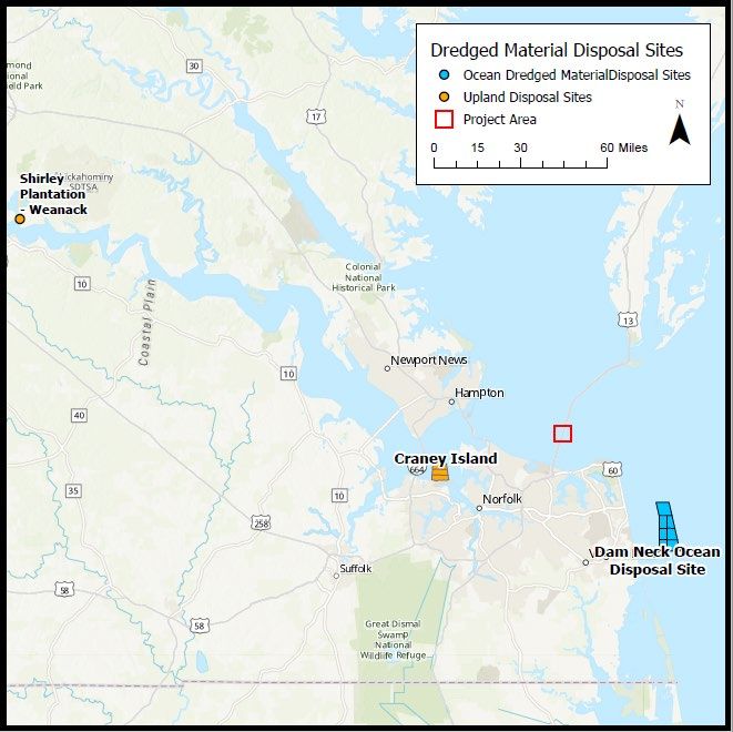
dredged material from construction of the WID trench for placement at Dam Neck Ocean
Disposal Site (DNODS) located in federal waters.
The new work conventional dredging (including mechanical and hopper) methods of the Norfolk
Harbor Channels including the CBBT PRB project were specifically addressed in the 2018
GRR/EA EFH Assessment. After USACE consultation with the National Marine Fisheries
Service, the effects conclusion was determined to be “negligible to minor, adverse impacts to
some EFH is anticipated, however no impacts are anticipated to substantively impact EFH.”
Additional new work dredging by means of conventional dredges will be required for the
construction of the WID receiving trench (as part of the WID method). However, since the
additional conventional dredging will be conducted within the previously coordinated Action
Area as part of the same project and in the same manner as coordinated in the 2018 GRR/EA
EFH Assessment, USACE Norfolk District has determined that the conventional new work
1U.S. Army Corps of Engineers CBBT PRB EFH Assessment
dredging portion of the proposed alternative is covered in the 2018 GRR/EA FCD finalized on
20 March 2018. Therefore, this EFH assessment mainly focuses on the impacts associated with
the WID methodology.
Scope of Dredging and Dredged Material Placement
The tunnel cover area proposed for removal is approximately 150 feet wide by 1,200 feet long
area (Figure 1) in the Thimble Shoal Channel over the existing CBBT. Dredging of the CBBT
cover area will be performed by WID means and methods to a maximum depth of -61 feet
MLLW displacing up to 43,000 cubic yards (CY) of material for permanent dredged material
placement into the adjacent WID trench. The construction of the WID trench will be required in
order to facilitate the displacement of the CBBT cover material through a downgradient density
current, and to act as a depository for the dredged material. The dredging depths of the receiving
trench will vary along the down-sloping gravity density gradient to a maximum dredging depth
of -70 feet MLLW to accommodate the CBBT cover material. The proposed depth of the WID
trench is also necessary to effectively contain the CBBT cover dredged material below the
maximum authorized dredging prism of the Thimble Shoal Channel of -61 feet MLLW. The
receiving trench will be rectangular in shape, up to 1,200 feet long and 525 feet wide,
approximately 15 acres in size and contiguous with the CBBT cover area. Construction of the
WID trench will require the removal of approximately 250,000 cy of dredged material within the
channel footprint. The WID trench will be dredged by a mechanical or hopper dredge and
placed onto ocean-going vessel/scow for dredged material transport to the DNODS (Figure 2).
It is possible that portions of the dredged material may be suitable for beneficial use projects.
The Craney Island Eastward Expansion (CIEE) project and the Craney Island Dredged Material
Management Area (CIDMMA) as well as beach nourishment projects in the City of Virginia
Beach and the City of Norfolk will be considered for beneficial use of dredged material as an
alternative of the dredged material placement. The dredged material discussed in this assessment
and in the SEA could be used for the dike construction for the CIDMMA and CIEE project or
used for beach nourishment projects placed landward of the depth of closure if the local sponsor
is willing and able to pay the additional incremental costs for that placement over and beyond the
costs of the Federal Standard.
2U.S. Army Corps of Engineers CBBT PRB EFH Assessment
Dredging of the WID trench and CBBT cover area is expected to commence in June/July 2022
and be completed within approximately 180 to 270 days.
EFH Assessment Supplemental Questions
Describe how the project would impact each of the habitat types selected above. Include
temporary and permanent impact descriptions and direct and indirect impacts.
• Noise
Noise and vibration sources from the proposed project are likely to occur in the project footprint
and action area as a result of the water injection dredge, dredged material placement/disposal areas,
and the transit of dredging and support vessels through the project area. The 2018 GRR/EA
evaluated the impacts of noise and vibration levels of hydraulic pipeline cutterhead dredges,
hopper dredges, bucket dredges. The noise levels of water injection dredging (WID) are
comparable, if not lower than the conventional methods that were already discussed with 2018
GRR/EA (PLA, 2007). Therefore, minimal temporary impacts from WID are expected.
• Water Quality
The Proposed Action would result in temporary impacts to water quality at the dredging and
placement sites. Placement of the WID trench material at the DNODS must receive MPRSA
Section 103 concurrence from EPA prior to disposal. Placement of the CBBT cover material
through WID methods must receive State 401 Water Quality Certification prior to the start of
construction.
o Impacts to Water Quality at the WID Trench Dredging Site
Resuspension of sediment is expected with dredging however, this impact can be
minimized through operational controls. Impacts to water quality from conventional
dredging (i.e. clamshell bucket and/or hopper barge) dredging would be minor, temporary
and localized to the area around the dredge. Localized turbidity would dissipate once
dredging has ceased (USACE, 2018). Based on data collected from the 2020 sediment
testing event by E.A. Engineering, the ambient turbidity at the project location averaged
to 2.56 NTU at the surface, and 9.86 NTU at the bottom of the water column (EA 2021).
TSS concentrations associated with mechanical clamshell bucket dredging operations have
been shown to range from 105 mg/L in the middle of the water column to 445 mg/L near
3U.S. Army Corps of Engineers CBBT PRB EFH Assessment
the bottom (210 mg/L, depth- averaged) (USACE, 2001). TSS concentrations associated
with a hopper dredging operation in the Thimble Shoal Channel in 1978 showed 2000mg/L
in the overflow plume near-surface. In the absence of overflow, a turbidity plume is not
encountered in the surface or middle of the water column depths and the maximum
suspended sediment level in the near-bottom plume was 70 mg/L (USACE, 2015).
The Proposed Action will cause a temporary increase in the amount of turbidity and TSS
in the action area; however, suspended sediment is expected to settle out of the water
column within a few hours and any increase in turbidity and TSS will be short-term.
Increased depths from dredging in estuarine environments also has the potential to alter
salinity levels within the dredging footprint and can also potentially result in changes in
DO levels. It should be noted, the CBBT cover material is sandy/gravely with minimal
fines and organic material that may have an oxygen demand.
The flushing rate (due to the water exchange and tidal fluctuations) within the project area
will minimize potential impacts due to changes in the DO levels. This flushing rate will
also cause TSS/turbidity plumes to dilute and disperse quickly, minimizing long-term
impacts to water quality. These factors combined with the operational controls like
enclosed buckets on the dredge will help to minimize impacts to water quality (Wilbur and
Clarke 2001). The CBBT cover material is comprised of greater than 90% sand and gravel,
which is expected to settle quickly into the WID trench. The WID trench material is
approximately 25% fine-grained silt/clay and 75% fine-grained sand, also expected to have
a high settling rate, comparable to the Thimble Shoal Channel dredging for the deepening.
Due to the area of impact and relatively short duration of the dredging activity, the
Proposed Action would not significantly impact water quality in the area of potential
impacts.
o Impacts to Water Quality at the CBBT Cover Water Injection Dredging Site and
Trench Placement Site
Impacts to water quality from the water injection method of dredging has showed to be
minor and temporary. A study completed by the U.S. Army Engineer Research and
Development Center indicated that most of the material moved by the WID in the upper
Mississippi River remained within the bottom three to five feet of the water column and
4U.S. Army Corps of Engineers CBBT PRB EFH Assessment
was not dispersed into the upper portion of the water column (Welp et al., 2017). The
physical characteristics of the material in the CBBT cover area is physically comparable
to the material found in the upper Mississippi River, therefore similar fall or settling
velocity effects are anticipated. The WID method has been shown to induce very little
TSS into the water column. Most of the fluidized material remains close to the sediment
bed in a density current. (Wilson, 2007).
The Proposed Action of WID of the CBBT cover material will cause a temporary
increase in turbidity and TSS in the Action Area while the material is being fluidized,
displaced and deposited in the WID trench. The suspended solids are expected to follow
the density gradient created by the construction of the WID trench and stay in the bottom
few feet of the water column for a short period of time. Due to the minimal impact of the
suspended solids in the water column and relatively small Action Area, the Proposed
Action of WID would not significantly impact water quality.
o Impacts to Water Quality at the Proposed Placement Site (DNODS)
Dredged material removed from the proposed WID trench site would be transported to
the DNODS for ocean disposal, pending EPA concurrence. Temporary turbidity impacts
to water quality during dredged material disposal would occur at the proposed placement
site. The material plume will primarily settle through the lower half of the water column
due to the high density of the dredged material and the estimated release point for the
dredged material in fully loaded scows or hopper dredges varies between -19 to -30 feet
below the sea surface depending on the vessel characteristics. Increased sediment loads in
the water column can result in a reduction of DO through biochemical oxygen demand.
These impacts may be more pronounced during late summer months when water
temperatures are warmer and less capable of holding DO. Analysis of elutriate data for
both the CBBT material and the WID materials indicate that neither the dredging nor
placement activities are expected to result in release of metals or organic contaminants to
the water column above those reported in ambient site water or in excess of EPA acute
water quality criteria for aquatic life. Water column bioassay results do not indicate the
dredged material will result in acute toxicity to appropriately sensitive benchmark
organisms exposed to the liquid and suspended particulate phase of dredged material.
5U.S. Army Corps of Engineers CBBT PRB EFH Assessment
Due to the area of impact and relatively short duration of the discharge activity, the
Proposed Action is not likely to significantly impact water quality at the DNODS.
• Vessel Traffic
Vessel traffic impacts from the water injection dredging barge will be short in duration, causing
minor and temporary effects. The Proposed Action of WID is projected to be short in duration,
with a period of performance of approximately 270 days. The long term impacts of vessel traffic
from the Norfolk Harbor Navigation Improvements Project were assessed in the 2018 GRR/EA,
concluding that the vessel traffic would actually decrease with the planned deepening of the
Norfolk Harbor Channels because larger ships in the fleet would carry more goods, thus
requiring a smaller number of ships to transport the same amount of goods.
• Benthic Community Disturbance
The CBBT cover removal project would result in localized, temporary impacts to existing
resources in the dredging area and placement sites. The dredging activities within the CBBT
cover area, WID trench and placement at the DNODS would result in the destruction of the
existing non-motile benthic community; however, repopulation of benthic organisms within the
impact area would begin quickly. The benthic community should repopulate within one to two
years.
• Impacts to Prey Species
Impacts to migration and spawning of prey species can lead to indirect adverse impacts to EFH
designated for bluefish, summer flounder, windowpane flounder, and other piscivorous fishes
that feed on anadromous fishes migrating through the Action Area. The extent of the turbidity
plume in the Action Area is expected to be minor due to the high density of the dredged material
and high fall rate. The Action Area is centered in the middle of the mouth of the Chesapeake
Bay; a 22,000-meter open water project area which allows for migrating prey species to continue
to migrate around the dredging site.
Benthic impacts from dredging activities will likely result in some mortality of benthic prey
species consumed by managed fishes, but it is likely that these prey species would quickly re-
colonize the area following dredging events and essential habitats would return to their current
6U.S. Army Corps of Engineers CBBT PRB EFH Assessment
state. While we would anticipate impacts to managed species as a result of increased depths and
dredging frequency of the federal navigation channels, impacts are anticipated to be minor and
temporary in nature.
• Water Depth Change
The water depth of the WID trench will be increased to a maximum depth of -70 ft MLLW for a
short duration, anticipating the acceptance of the CBBT cover material. After the WID of the
CBBT cover area, and as the fluidized material is conveyed to the WID trench, it is expected that
the water depth will vary but be no shallower than -61 ft MLLW within the WID trench at
completion of project activities. Natural shoaling processes of native alluvial sediments is
expected to accrete in the WID Trench until the area reaches an equilibrium with surrounding
channel depths. Therefore, changes in the water depth of the WID trench would be temporary.
• Fill
The CBBT cover area was tested to determine dredged material suitability for placement in
Waters of the U.S. in accordance to Section 404 of the Clean Water Act of 1977 (Public Law 95-
217). The Norfolk District has determined that the dredged material from the CBBT cover area,
proposed for WID and WID trench placement, complies with the Section 404(b)(1) of the Clean
Water Act. The preliminary characterization data generated and presented in the Supplemental
Environmental Assessment were in accordance with Section 404 (b)(1) Guidelines developed by
EPA in conjunction with the USACE (Appendix H).
What specific measures will be used to avoid impacts, including project design, turbidity
controls, acoustic controls, and time of year restrictions? If impacts cannot be avoided, why not?
The project is designed with the minimal footprint necessary to complete the project purpose,
minimizing impact to the essential fish habitat. Turbidity impacts from the water injection
dredging method are mainly unavoidable but are considered to have lower adverse effects
compared to conventional methods (i.e. hopper and clamshell). Turbidity from the WID method
are anticipated to remain in the lower 3 feet to 5 feet of the water column (Welp et al., 2017).
The fine to medium grained sand in the within the project area will likely settle out of the water
column at a faster rate than fine sediments, minimizing the impacts of the turbidity caused by the
WID method.
7U.S. Army Corps of Engineers CBBT PRB EFH Assessment
The project location is within the Thimble Shoal Channel at the mouth of the Chesapeake Bay.
The width of the Bay is approximately 22,000 meters wide at the project location, allowing for
aquatic life in the project area to be able to leave the disturbance area out of the turbidity plume.
The 2018 GRR/EA evaluated the impacts of noise and vibration levels of conventional dredging
methods with the conclusion that the relative level of impact would be slightly higher than the
No Action Alternative due to dredging and dredged material placement. The noise levels of
water injection dredging are comparable, if not lower than the conventional methods that were
already discussed with 2018 GRR/EA (PLA, 2007).
What specific measures will be used to minimize impacts?
• Agitation and operation of the water injection dredging would not begin until the manifold is
in the immediate vicinity of the substrate, minimizing turbidity in the upper water column.
• Disposal of dredged material will occur within the confines of the Dam Neck Ocean Disposal
Site and within the WID trench. No unconfined disposal of contaminated sediments would
occur with implementation of the Action Alternative.
8U.S. Army Corps of Engineers CBBT PRB EFH Assessment
Figures
Figure 1: Project Location
9U.S. Army Corps of Engineers CBBT PRB EFH Assessment
Figure 2: Dam Neck Ocean Disposal site in relation to project area (Preferred Alternative)
10U.S. Army Corps of Engineers CBBT PRB EFH Assessment
Figure 3: SAV Presence in the Project Area
11U.S. Army Corps of Engineers CBBT PRB EFH Assessment
References
EA Engineering, Science, and Technology, Inc. 2021. Evaluation of Dredged Material: Norfolk
Harbor Improvements Project –Thimble Shoal Channel, Meeting Area 2, CBBT Cover. Prepared
for Virginia Port Authority.
Port of London Authority (PLA). June 2007. Baseline Document for Maintenance Dredging.
U.S. Army Corps of Engineers (USACE) June 2018. Norfolk Harbor Navigation Improvements.
Final General Reevaluation Report and Environmental Assessment.
U.S. Army Corps of Engineers (USACE). July 2015. Dredging and Dredged Material
Management, Engineer Manual. EM 1110-2-5025. Washington, DC:
http://publications.usace.army.mil/publications/
U.S. Army Corps of Engineers (USACE). 2001. Monitoring of Boston Harbor confined aquatic
disposal cells. Compiled by L.Z. Hales, ACOE Coastal and Hydraulics Laboratory.
ERDC/CHLTR-01-27.
Welp, T. L., M. W. Tubman, D. A. Wilson, and C. E. Pollock. 2017. Water injection dredging.
ERDC TN-DOER-T14. Vicksburg, MS: U.S. Army Engineer Research and Development
Center. www.wes.army.mil/el/dots/doer
Wilbur, D.H. and D.G. Clarke. 2001. Biological effects of suspended sediments: A review of
suspended sediment impacts on fish and shellfish with relation to dredging activities in estuaries.
North American Journal of Fisheries Management 21:4, 855-875.
Wilson, D. A. 2007. Water injection dredging in U. S. waterways: History and expectations. In
Proceedings, World Dredging Congress. Orlando, FL.
12You can also read