太空|TAIKONG ISSI-BJ Magazine - No. 15 - December 2019 - International Space Science Institute
←
→
Page content transcription
If your browser does not render page correctly, please read the page content below
太空|TAIKONG
                      ISSI-BJ Magazine
国际空间科学研究所 - 北京
                         No. 15 - December 2019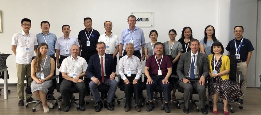
IMPRINT FOREWORD
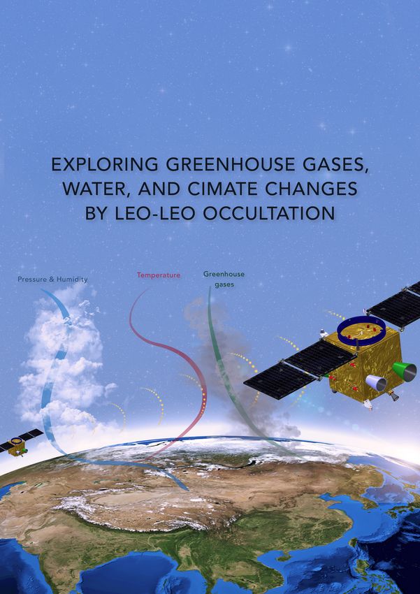
太空 | TAIKONG The forum "Exploring greenhouse gases, summer of 2017, the CACES mission was
ISSI-BJ Magazine water and climate changes by LEO- selected as one of the concept missions
License: CC BY-NC-ND 4.0
LEO occultation” represents the third for advanced studies in the space science
forum that was successfully organized program of the Chinese Academy of
by the International Space Science Sciences and it was approved for a two-
Institute in Beijing (ISSI-BJ) in 2019. year pre-study in 2018-2019.
ISSI-BJ forums are informal, free debates
Address: No.1 Nanertiao, and brainstorming meetings on open The participants recognized the high
Zhongguancun, scientific value of the mission and raised
questions of scientific nature discussed
Haidian District,
by 20-25 scientists, and this time, the constructive comments and suggestions
Beijing, China
Postcode: 100190 event was held in the context of the concerning the mission concept, its
Phone: +86-10-62582811 Space Science Strategic Pioneer Project payloads, key techniques, and data
Website: www.issibj.ac.cn of the Chinese Academy of Sciences products. It was concluded that the
(CAS). CACES mission is technologically
Authors interesting and timewise very
Liu Congliang - NSSC, CAS, The two-day activity, which was attended appropriate, it attracts a broad audience
China by almost 30 scientists coming from six worldwide, and has complementary
Gottfried Kirchengast - different countries, was held on July 24- objectives with other Earth Science
WEGC, University of Graz,
Austria 25, 2019, in Beijing. It was designed to missions. Therefore, the CACES mission
Sun Yueqiang - NSSC, CAS, provide a brainstorming opportunity to is an excellent example of the innovative
China
reflect on the most important scientific and challenging character of the
Wang Xin - IAP, CAS, China
Lv Daren - IAP, CAS, China developments in the field and how to Chinese Space Science Program as well
Bai Weihua - NSSC, CAS, achieve them from a technological point as of its complementarity to existing and
China
Du Qifei - NSSC, CAS, China
of view. For this purpose, the forum future missions. This offers significant
Armin Löscher - ESA Future brought together prominent field experts opportunities for cooperation through
Missions & Instruments focusing both on scientific research mission coordination and scientific
Division, Netherlands
Stig Syndergaard - DMI, (theorists and observers) as well as analysis that places CACES and China
Denmark instrumentation. A special attention and in a strategic position due to its unique
Tian Longfei - IAM, CAS, consideration were given to the mission objectives and technology.
China
Zhang Zhihua - IAP, CAS, “Climate and Atmospheric Composition
China Exploring Satellites mission” (CACES), In the light of the forum's goals, this
on its key science goals and mission TAIKONG magazine provides an
Editor definition as well as on some of the key overview of the scientific objectives and
technological challenges. In fact, in the the overall design of the CACES project,
Laura Baldis
International Space Science
Institute - Beijing
FRONT COVER
Image Credits: Innovation Academy for
Microsatellites of CAS (microsat)
2 太空|TAIKONG
including details concerning the spacecraft and      (DMI Copenhagen, DK) and A.Prof. Congliang
instrumentation discussed during the forum.          Liu (NSSC, CAS, CN). Finally, I would like to
                                                     express my gratitude to ISSI-BJ Administrative
I would like to thank all forum participants for     Director Prof. Xiaolong Dong as well as ISSI-BJ
their contribution to the activity and extend        staff - Lijuan En and Laura Baldis - for actively
special thanks to its conveners and organizers       supporting the organization of the forum.
Prof. Gottfried Kirchengast (WEGC, University
of Graz, AT), Prof. Daren Lv (IAP, CAS, CN), Prof.
Yueqiang Sun (NSSC, CAS, CN), Prof. Quanlin
Fan (NSSC, CAS, CN), Dr. Xin Wang (IAP, CAS,
CN), Dr. Armin Löscher (ESA Future Missions &
Instrument Division, NL), Dr. Stig Syndergaard

                                                                                Maurizio Falanga,

                                                                               Executive Director
                                                                                          ISSI-BJ

                                                                        太空|TAIKONG                  3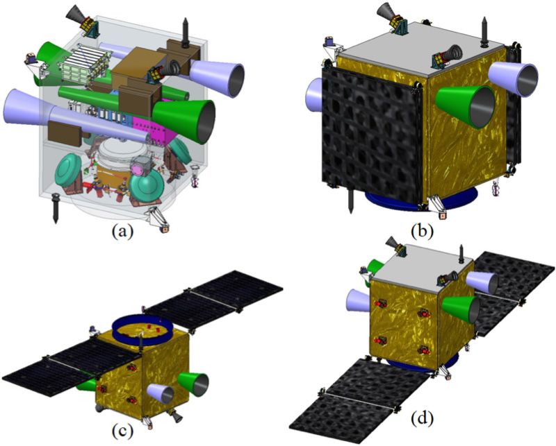
1.      INTRODUCTION

As the International Space Science Institute in   the Wegener Center for Climate and Global
Beijing (ISSI-BJ) is devoted to the achievement   Change (WEGC), University of Graz in Austria,
of a deeper scientific and technological          Prof, Daren Lv and Dr. Xin Wang from the
understanding of a wide range of space            Institute of Atmospheric Physics (IAP, CAS),
science disciplines, the exploring greenhouse     Prof. Yueqiang Sun, Prof. Quanlin Fan and
gases, water and climate changes by LEO-LEO       A.Prof. Congliang Liu from the National Space
occultation forum, aimed to investigate the       Science Center (NSSC, CAS), Dr. Armin Löscher
role and contribution of the essential climate    from the European Space Agency (ESA) Future
variables (ECVs), such as the atmospheric         Missions & Instrument Division in Netherlands,
thermodynamic state variables and greenhouse      Dr. Stig Syndergaard from the Danish
gases, to the atmosphere physical processes       Meteorology Institute (DMI) in Denmark and
and global climate change.                        Prof. Maurizio Falanga from ISSI-BJ. About 30
                                                  leading scientists on atmosphere and climate
Given the need of improvements in existing        research from Austria, Denmark, Germany,
ground-based and satellite observations           Netherlands, United States and China
to successfully deliver atmosphere and            participated in this forum. The objective of this
climate benchmark data and to reduce data         forum was to provide an open brainstorming
ambiguity, the discussion focused on three        opportunity to discuss scientific scenarios
main subjects: the key scientific questions and   and mission definition, as well as some of the
responses of ECVs in relation to global change;   technical and information retrieval challenges
the principles, algorithms and payloads of        of the CACES mission.
microwave occultation-using centimeter and
millimeter wave signals between low Earth orbit   The forum’s schedule, spread over two days,
satellites (LEO-LEO microwave occultation,        neatly reflected the content focus, as its first
LMO) as well as of the LEO-LEO infrared-laser     day started with an overview of the LEO-
occultation (LIO); the Climate and Atmospheric    LEO occultation technique and the review
Composition Exploring Satellites (CACES)          of previous studies in Europe as well as in
mission concept proposed to the Strategic         China, which was brilliantly provided by Prof.
Priority Research Program of Chinese Academy      Kirchengast, Dr. Löscher, and A.Prof. Liu, and
Science (SPRPCAS).                                followed by the insightful overview on the
                                                  CACES mission and scientific challenges in
A two-day international forum on exploring        greenhouse gases, water, and climate change
greenhouse gases, water and climate changes       studies. As the second day started, a deeper
by LEO-LEO occultation was held at the ISSI-      understanding of the CACES mission concept
BJ from July 24 to 25, 2019. This forum was       design as well as of complementary missions
convened by Prof. Gottfried Kirchengast from      and scientific international collaborations could

 4        太空|TAIKONG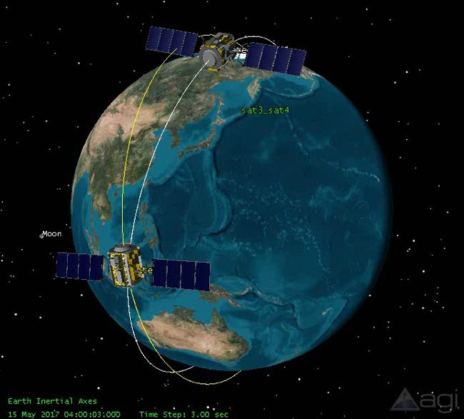
be achieved, therefore allowing conveners              the discussions, the participants confirmed
and participants to elaborate on solid ground          the significance of the scientific objectives
the discussion concerning the science goals            and necessity of the CACES mission for global
of CACES, on data observing and gathering              climate and water cycle research and showed
techniques, as well as on the potential of             interests in collaboration in future research. The
international partnerships.                            forum also provided important suggestions
                                                       for further demonstration and promoting the
During the meeting, key science topics and new         preparation of the mission.
research perspectives, requirements of climate
monitoring and modeling with observation               This TAIKONG magazine presents an overview
data, requirements of essential climate                of the LEO-LEO technique and its status and
variables (ECVs) observation for technologies          then focuses on the CACES mission with its
and the payload selection and configurations           scientific objectives, mission concept, payloads
of the CACES mission were discussed. During            design and the major outcome from this forum.

       1.1.       GNSS Radio Occultation as basis for LEO-LEO

The concept of radio occultation (RO) originated       Operational Satellite-A (MetOp-A) (Luntama et
from interplanetary space exploration in the           al., 2008), the Constellation Observing System
1960s for probing the atmosphere of Mars               for Meteorology, Ionosphere and Climate
(Kliore et al., 1965; Fjeldbo et al., 1971). Decades   (COSMIC) (Anthes et al., 2008), and FengYun-
later, with the emergence of the Global                3C/-3D GNSS Occultation Sounder (FY-3C/-3D
Positioning System (GPS) constellation, Yunck          GNOS) (Liao et al., 2016) etc.
et al. (1988) suggested that RO could also be
used to probe the Earth’s atmosphere, with the         In the RO data validation and assessment,
source being the available GPS signals, and the        GRO’s excellent features of global coverage, all
receiver being in a low Earth orbit (LEO). In this     weather capability, high accuracy, high vertical
paper we refer to this as the Global Navigation        resolution, no need for calibration, very high
Satellite System RO (GRO) technique. The GRO           precision, long-term stability, low structural
technique was demonstrated using GPS signals           uncertainty, negligible satellite to satellite bias
in the proof-of-concept GPS/Meteorology                were proven (Schreiner et al., 2007; Anthes et
(GPS/MET) mission (Kursinski et al., 1996),            al., 2008; Steiner et al., 2013; Scherllin-Pirscher
subsequently, many GRO missions have been              et al., 2017).
launched, such as the Challenging Minisatellite
Payload (CHAMP) (Wickert et al., 2001),                Due to these positive features, GRO has been
Gravity Recovery and Climate Experiment-A              recognized as an important data source for
(GRACE-A) (Beyerle et al. 2005), Meteorological        improving weather forecasts and for monitoring

                                                                           太空|TAIKONG                  5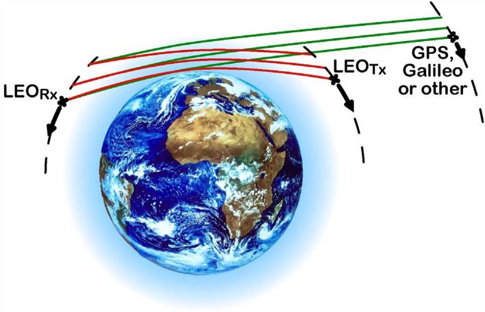
climate change. Today GRO products, in                and global climate monitoring (GCM) (e.g.,
particular bending angle and refractivity, are        Steiner et al., 2011; Foelsche et al., 2009;
widely used for numerical weather prediction          Lackner et al., 2011).
(NWP) (e.g., Healy and Thepaut, 2006; Cucurull
and Anthes, 2014; Aparicio and Laroche, 2015)

      1.2.       LEO-LEO Occultation - The Next Generation GNSS RO

While many scientists have reported significant       to solve the temperature-humidity ambiguity
positive impacts of GRO products on NWP and           in the troposphere. Thus, LMO promises to
GCM, GRO has an inherent limitation, which            enable the retrieval of temperature, pressure,
is the inability to separate the contributions        and humidity profiles without auxiliary
of temperature and humidity to the total              background information, by using various X/K
refractivity (Yunck et al., 2000; Kursinski et al.,   band and M band frequencies around the
1997). Therefore, in the troposphere where            22 GHz and 183 GHz water absorption lines
the contribution from humidity cannot be              (Kursinski et al., 2002a; Kirchengast and Høeg,
neglected, the temperature and humidity               2004; Gorbunov and Kirchengast, 2005, 2007;
variables can only be retrieved separately from       Schweitzer et al, 2011). Similarly, ozone profiles
refractivity by co-using a priori humidity and/       can be retrieved by absorption measurements
or temperature information (Kursinski and Hajj,       of signals near the 195 GHz ozone line (Feng
2001; Hajj et al., 2002). This is the main reason     et al., 2001; Kursinski et al., 2009). Furthermore,
why scientists started to explore and suggested       the liquid water and ice cloud variables as well
microwave occultation using centimeter and            as turbulence strength can also be retrieved as
millimeter wave signals between LEO satellites.       by-products (Kursinski et al., 2009; Kirchengast
                                                      and Schweitzer, 2011).
The LMO technique exploits both the
refraction and the absorption of the signals

 Figure 1: Schematic view of the GRO (green signal paths) and LEO-LEO occultation (red signal paths)
                                            event geometry.

 6         太空|TAIKONG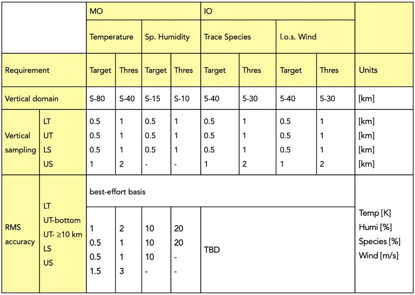
The LIO technique, proposed as part of            2a and 2b) were investigated and suggested
ACCURATE mission (Kirchengast et al., 2010a),     for the LMO signals. LMO channels including
uses laser signals in the short-wave infrared     (a) centimeter-wave signals in X/K band (core
(SWIR) band 2-2.5 µm between LEO satellites,      channels K1-K3), exploiting the 22 GHz water
to accurately observe key trace species for       vapor absorption line, and (b) millimeter-wave
chemistry and climate (i.e., greenhouse gases     signals in M band (primary channels M1-M2),
H2O, CO2, CH4, N2O, O3, CO, including key         exploiting the 183 GHz water vapor line and
isotopes), line-of-sight (l.o.s.) wind speed,     the 195 GHz ozone line.
and also profiles of cloud layers and aerosols
as by-products (Kirchengast and Schweitzer,       Furthermore, SWIR frequency channels were
2011). An overview of the GRO and LEO-            carefully selected for the LIO signals to match
LEO occultation measurement concept and           desired absorption lines of trace species of
geometry are shown in Figure 1.                   interest. All channels include suitable reference
                                                  channels, or in case of LMO, use nearby
Figure 2 shows the spectral bands and             channels as reference, for enabling effective
distribution of the LMO and LIO (LMIO)            use of differential transmission between
channels. Channels at the wings of the 22         channels (Figure 2c and 2d). Figure 2e-2g
and 183 GHz water absorption lines (Figure        highlight specific LIO channels. LIO channels

           Figure 2: Spectral bands and distribution of the LMO and LIO (LMIO) channels.

                                                                      太空|TAIKONG                7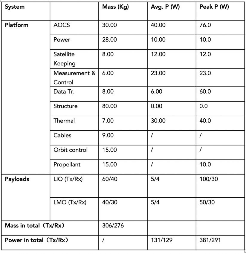
including shortwave-infrared (SWIR) laser           g) Further refined zoom in SWIR-A, highlighting
signals (c) in the 2.3 to 2.5 µm SWIR-B band,       the "wind line" band of only ~40 pm (0.1 cm−1)
exploiting absorption lines of stratospheric        width. The selected two wind measurement
ozone and water vapor, water isotopes, carbon       channels sit at the inflection points of the highly
monoxide and methane, and (d) in the ~2.1 µm        symmetric and stable C18OO line (Figure 2f)
SWIR-A band, exploiting lines of nitrous oxide,     and the spectral derivative of the transmission
carbon dioxide, isotopes, and water vapor.          (Figure 2g) confirms that the wind channels are
                                                    located at the maximum gradient providing
(e) Zoom into a narrow sub range of the SWIR-A      highest sensitivity to wind-induced Doppler
band, highlighting a special "demonstration"        shift of the line. (Kirchengast and Schweitzer,
band of only ~4 nm (10 cm−1) width, suitable        2011)
to probe the key variables CO2 and isotopes,
H2O, and l.o.s. wind within the mode-hop free
tuning range of single SWIR diode lasers. (f and

      1.3.       Climate, Greenhouse Gases, and Water Scientific
      Challenges

A deeper understanding of how greenhouse            expanding the observational foundation for
gases and water vapor impact and respond            climate change studies by accurate, long-term,
to the global climate change is one of the          consistent benchmark data is a fundamental
outstanding challenges in Earth climate science.    need of climate science.
As the community gains the consensus of the
global warming and a deeper understanding of        In situ observing stations, mainly deployed
the many processes involved, the greenhouse         on land, buoys, ships, balloons or aircraft
gases and water vapor are playing critical roles.   can be highly accurate but suffer from poor
Reduction of uncertainties in greenhouse            representativeness as they offer point or line
gases climate feedbacks as well as improved         measurements in space and/or time. They are
understanding of processes governing                very irregularly distributed around the globe,
these effects will result from profiling of the     particularly their density is poor over remote
atmospheric thermodynamic state variables           regions and oceans, and vertical profiles are
(i.e., pressure, temperature and humidity),         rare.
greenhouse gases (i.e., H2O, CO2, CH4, N2O,
O3, CO, including key isotopes), and l.o.s. wind    Earth observation from space is the key
speed with improved accuracy and vertical           approach to obtain such data globally. Current
resolution compared to existing ground-based        methods of satellite remote sensing of Earth’s
and space-based measurements. Therefore,            free atmosphere (above boundary layer) do

 8         太空|TAIKONG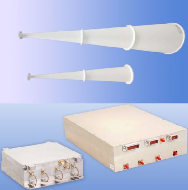
collectively enable global observations of          over decades and longer, high accuracy tied
ECVs, including thermal state (temperature,         to international metrological standards and un-
pressure, humidity), dynamics (wind), and           biased spatiotemporal sampling. Despite the
composition (ozone, carbon dioxide, methane,        demand and having GRO as a valuable starting
other greenhouse gases), but are struggle to        point for refractivity, such a fundamentally
provide them as consistent climate benchmark        needed “full atmospheric state” method did
dataset. The latter requires joint sensitivity to   not exist so far.
all essential variables, measurement stability

2.      CHALLENGING REQUIREMENTS IN CLIMATE SCIENCE
                 AND KEY OBSERVATIONS

The Intergovernmental Panel on Climate              are one of the key questions in the earth and
Change (IPCC) reported that scientific evidence     climate science.
for warming of the climate system is unequivocal,
such as global temperature rise, warming            However, the existing ground-based and
oceans, shrinking ice sheets, glacial retreat,      satellite observations are still far from fully
decreased snow cover, sea level rise, ocean         supporting properly the atmospheric physics
acidification and so on. IPCC also concluded        and global climate change research that
there's a more than 95 percent probability that     requires long-term stable, global coverage,
human activities over the past 50 years have        high spatial resolution and simultaneous
warmed our planet by emitting greenhouse            measurement of ECVs, to deliver atmosphere
gases i.e., CO2, CH4, NO, etc., into the Earth      and climate benchmark data. The benchmark
atmosphere. However, the consequences of            observations are also helpful to understand the
changing the natural atmospheric greenhouse         exchanges among the atmospheric water vapor,
are difficult to predict, as well as the physical   ice liquid water and ice crystals, under strong
and chemical impacts and feedbacks of the           convection conditions. Based on Kirchengast
atmospheric composition and climate change          et al. (2010b), who introduced the "scientific
are uncertain.                                      objectives vs. impact matrix approach" as a
                                                    method for effectively assessing the value of
The atmospheric thermodynamic state variables       observing systems, Table 1 summarizes the
and greenhouse gases are essential climate          scientific objectives and provides a convenient
variables (ECVs) and significant in physical and    “shortcut form” for them that is then used in
chemical processes of the atmosphere, which         the Impact Level matrix (Table 2).
play very important roles in the earth system,
ecosystem and human society. The impacts            GRO has become a major method to
and feedbacks of these ECVs to global change        observe the atmospheric thermodynamic

                                                                      太空|TAIKONG                 9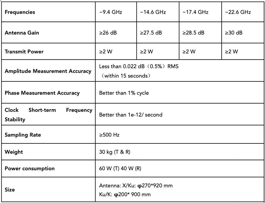
Scientific Objective – Shortcut Form                       Scientific Objective Description
                                                   Climate
        Monitor climate trends and variability         Monitoring of climate trends and variability in
                                                       thermodynamic, dynamics/wind, greenhouse gases,
                                                       reactive gases, aerosol, cloud/precipitation, and radiation
                                                       variables, for contributing to accurate long-term
                                                       observations of climate in the atmosphere
        Diagnose and predict climate change            Diagnostics, including detection and attribution, of
                                                       anthropogenic climate and composition changes in
                                                       the atmosphere, as well as of changes in the global
                                                       carbon and water cycles, and support to climate change
                                                       predictions via accurate data
      Validate, test and improve climate GCMs          Validation of global circulation models (GCMs),
                                                       in simulated mean climate and variability seen in
                                                       atmospheric physics/composition/radiation variables, and
                                                       testing and improvement of their process formulations
     Understand climate forcing and feedbacks          Improvement of the understanding of climate forcing
                                                       variations (e.g., greenhouse gases and aerosol) and
                                                       of climate feedbacks determining magnitude and
                                                       characteristics of climate changes

                                          Chemistry & Processes
 Study atmos. processes near-surface & in the LT       Study of atmospheric processes near surface and in the
                                                       lower troposphere (LT), in the context of atmospheric
                                                       chemistry and physics research, including also aerosol,
                                                       cloud, and dynamical variability studies
        Study atmos. processes in the UTLS             Study of atmospheric processes in the UTLS region at
                                                       high resolution, in the context of atmospheric chemistry
                                                       and physics research, including also aerosol, cloud, and
                                                       dynamical variability studies
      Improve atmos. composition forecasting           Improvement of forecasting and analysis of atmospheric
                                                       composition including greenhouse gases, reactive gases,
                                                       and aerosols by atmospheric constituent model and data
                                                       assimilation systems
     Test and improve atmos. constituent models        Testing of constituent models and improvement of
                                                       their process formulations, in order to enhance their
                                                       composition forecasting skill

                                                    NWP
             Improve NWP forecasting                   Improvement of forecasting and analysis of weather
                                                       conditions, including in thermodynamic, dynamic/wind,
                                                       cloud/precipitation, and radiation variables, by weather
                                                       prediction (NWP) and data assimilation systems
           Test and improve NWP models                 Testing of NWP models and improvement of their
                                                       process formulations, in order to enhance their weather
                                                       forecasting skill

                                                   Others
Calibrate data from other atmos. observing systems     Provide reference data for the calibration, validation, and
                                                       analysis of data from other space missions or airborne/
                                                       ground-based observing systems
      Demonstrate a novel observing technique          Demonstrate the science value of a novel satellite-based
                                                       atmospheric remote sensing technique not yet used
                                                       before

                   Table 1: Scientific objectives used in the Impact Level matrices

10          太空|TAIKONG
state variables, which demonstrated that the analyses and forecasting, and anthropogenic
occultation observations have the atmosphere change detection and attribution.
and climate benchmark data features.
However, the GRO has a temperature and In the last decade, several LMO and LIO
humidity ambiguity problem. Fortunately, as missions for atmosphere and climate change
an advanced technique LMO can exploit both have been proposed to ESA and NASA,
the refraction and absorption of the signals to which resulted in many pre-studies. In China,
solve the temperature-humidity ambiguity in the Climate and Atmospheric Composition
the troposphere. Thus LMO enables to retrieve Exploring Satellites (CACES) mission concept
pressure, temperature, and humidity profiles has been proposed to the Strategic Priority
without background information. Liquid water Research Program of the Chinese Academy
and rain rate profiles as well as turbulence Science (SPRPCAS). A mission for benchmark
and complementary 3D cloud information can monitoring of the Earth's atmospheric
be co-observed. Additionally, the LIO, using thermodynamic state variables, greenhouse
laser signals in the short-wave infrared band gases and climate change by LMIO combined
from 2–2.5 µm, between LEO satellites, has with 3D clouds imaging from low Earth orbits.
been designed to accurately observe key trace
gas species for chemistry and climate (i.e., Table 2 shows the Impact level matrix for the
greenhouse gases H2O, CO2, CH4, N2O, O3, LMIO occultation technique. As is obvious,
CO, etc.), l.o.s. wind speed, and also profiles its unique and major strengths fall mainly
of cloud layers and aerosols as by-products. into the field of climate science via observing
LIO measures the absorption of the signals to thermodynamic variables, greenhouse gases,
retrieve volume mixing ratio (VMR) profiles of and wind from space with climate benchmark
the greenhouse gases. In order to mitigate the quality and with focus on the UTLS. Due to
effects of foreign species absorption, aerosol the accuracy and high vertical resolution,
extinction, scintillation, and scattering on the the ACCURATE data will have unique and
retrieved trace species profiles, LIO uses the major impact on atmospheric chemistry and
differential transmission principle between process studies in the UTLS, GHG composition
carefully selected pairs of absorption signals modeling, and calibration of data from
and reference signals. This enables accurate other observing systems. Furthermore, it
retrieval of the pure absorption profile due is a very novel technique therefore also its
to the target species and hence accurate demonstration is unique and of significant
greenhouse gas profiles. relevance.
Among further potential the LMIO method
enables to rigorously monitor how greenhouse
gas and climatic changes evolve from monthly to
decadal scales and it can serve as independent
observational constraint for model testing, re-
太空|TAIKONG 11Atmospheric Observation Information
Scientific Objectives ThDyn DynWind GHGs RAGs Aerosols Cls+Prec Radiation
Climate
Monitor climate trends *** *** *** ** ** * (*)
and variability
Diagnose and predict *** ** *** * * * (*)
climate change
Validate, test and *** ** *** * * (*) (*)
improve climate GCMs
Understand climate *** ** *** * * (*) (*)
forcing and feedbacks
Chemistry & Processes
Study atmos. processes * - * * * - (*)
near-surface and in
the LT
Study atmospheric *** ** *** ** ** * (*)
processes in the UTLS
Improve atmospheric ** * *** ** * - (*)
composition
forecasting
Test and improve ** * *** * * - (*)
atmospheric
constituent models
NWP
Improve NWP ** ** * * (*) (*) (*)
forecasting
Test and improve NWP ** * * * (*) (*) (*)
models
Others
Calibrate data from *** *** *** ** * (*) (*)
other atmospheric
observing systems
Demonstrate a novel *** *** *** *** ** * (*)
observing technique
Table 2: Scientific Objectives-vs-Observation Information Impact Level Matrix for LMIO
Remarks: *** unique impact (top; superior to all other known observation systems for the objective)
*** major impact (co-leading impact amongst all other known observation systems)
** significant impact (adding significant information to that of all other observation systems)
* contributing impact (contributing useful information to that of all other observation systems)
(*) indirect impact (providing useful indirect information)
- no impact
12 太空|TAIKONG3. STUDIES FOR LEO-LEO OBSERVATIONS FROM SPACE
After the GRO technique had been AMORE was highly ranked scientifically, it was
demonstrated by the GPS/MET mission, there considered technically immature and was not
have been many GRO missions to observe selected.
the atmospheric variable profiles from space,
such as CHAMP, GRACE-A, MetOp-A/-B, In 2007, the U.S. NSF funded a proposal for
COSMIC-1/-2 and FengYun-3C/-3D GNOS etc. development of the Active Temperature,
Ozone and Moisture Microwave Spectrometer
The work to develop the LEO-LEO occultation (ATOMMS) instrument and an aircraft-to-
technique has been ongoing for the last two aircraft occultation demonstration, with
decades, and a number of LMO proposals NASA providing the aircraft (Kursinski et al.,
and missions have been put forward mainly by 2009). While the aircraft demonstration never
U.S. and European scientists. In the following occurred due to funding limitations, this effort
we give a brief chronological history of these successfully developed a prototype ATOMMS
efforts, in part drawing from the report by instrument that probed both the 22 and 183
Syndergaard et al. (2009). GHz water vapor absorption lines and has been
used to demonstrate a number of key ATOMMS
In 1997, researchers at the Jet Propulsion capabilities via ground measurements
Laboratory (JPL) and the University of Arizona (Kursinski et al., 2012, 2016; Ward et al., 2017).
in the U.S. began exploring how frequencies
significantly higher than those of the GPS The LMO concept was also translated to Mars
could be used to measure the absorption of in a mission concept named Mars Atmospheric
water vapor due to its 22 GHz water vapor Climate Observatory (MACO) whose
resonance line (Hajj et al., 1997; Herman et al., development began with seed funding from
1997). This led to two large proposals being NASA in 2000 (Kursinski et al., 2004). MACO
submitted in 1998. The first, the Atmospheric was designed to characterize the Martian
Moisture and Ocean Reflection Experiment atmosphere and climate and, in particular, its
(AMORE) responded to the NASA Earth System hydrological, CO2, methane, energy and dust
Science Pathfinder (ESSP) Announcement of cycles using satellite-to-satellite microwave
Opportunity (AO). The second, the Active occultation complemented by solar occultation
Tropospheric Ozone and Moisture Sounder and IR and microwave thermal radiance
(ATOMS) was in response to the NASA observations.
Instrument Incubator Program (IIP) AO. AMORE
was piggybacked on the COSMIC mission In Europe, the retrieval strategy to separate
satellites, yielding a combined mission titled water vapor from temperature in the
COSMIC-AMORE, but later it was promoted as troposphere by adding Ku-band signal
a separate mission (Yunck et al., 2000). While crosslink measurements was proposed as early
太空|TAIKONG 13as 1996, as part of the first End-to-end GNSS inherited the LMO technique from the ACE+
Occultation Performance Simulator (EGOPS) mission and employed a novel concept of LIO
functionality definition document for ESA yielding LEO-LEO microwave and infrared-laser
(Kirchengast, 1996). Responding to an ESA call occultation (LMIO) (Kirchengast and Schweitzer,
for Earth Explorer Core Missions, a mission 2011). This initial ACCURATE mission concept
named WAter vapor and Temperature in the was submitted to an ESA selection process
troposphere and Stratosphere (WATS) was for the next Earth Explorer Missions in 2005
proposed by a European consortium in 2001 (Kirchengast et al., 2005b, 2007; Schweitzer,
(WATS, 2001). The WATS LMO concept was 2010a). Although ACCURATE was not selected
subsequently combined with an earlier GRO for a phase A study, it received very positive
mission concept (named Atmosphere Climate evaluation and was recommended for further
Experiment, ACE) in a new mission proposal, development and demonstration (Kirchengast
the so-called Atmosphere and Climate and Schweitzer, 2011). Therefore, a project called
Explorer Plus (ACE+), selected as top priority in Aid to ACCURATE Climate Satellite Mission
ESA’s 2nd Call for Earth Explorer Opportunity Preparations (ACCURAID) was supported by
Missions in 2001 (Høeg and Kirchengast, 2002; the Austrian Aeronautics and Space Agency
Kirchengast and Høeg, 2004). 2005 to 2007, which resulted in refinement of
the mission concept and consolidation of its
ACE+ was selected for phase A studies taking instrumentation (Kirchengast et al., 2007).
place in 2002-2004, but was not continued after
a mission down-selection round in 2004 though In 2010, a more mature mission concept was
the scientific and technical feasibility studies then proposed to ESA in response to the Call
showed the potential for implementation. A for Proposals for Earth Explorer Opportunity
comprehensive summary of the results coming Mission EE-8 (Kirchengast et al., 2010a). It
out of the ACE+ phase A study can be found in was not selected but highly rated again and
Kirchengast et al. (2005a). Two other microwave therefore supported for further studies, in
occultation studies, namely Alternative particular ground-based demonstration of
Measurement Techniques for LEO-LEO Radio infrared-laser occultation. Such initial ground-
Occultation (AlMeTLEO) (e.g., Cuccoli et based demonstration of the LIO method was
al., 2004; Facheris et al., 2008) and Galileo conducted by a campaign at the Canary Islands
Atmospheric Data Enhancement Mission in 2011 (Brooke et al., 2012; Proschek et al.,
(GADEM) (Schwärz et al., 2006; Kirchengast 2015), which was funded by the ESA’s Support
and Schwärz, 2006), were funded by ESA and to Science Element (STSE) and supported
EU, respectively, in 2004 to 2006. by the Earth Observation Future Missions
program, including ESA’s OGS facility.
In late 2004, the Atmospheric Climate and
Chemistry in the UTLS Region And climate YingHuo 1 (YH-1) is a micro-satellite developed
Trends Explorer (ACCURATE) mission was by Chinese Aerospace Industry, and planned to
conceived at Wegener Center (WEGC), which be launched together with Russian spacecraft,
14 太空|TAIKONGPhobos-Grunt, to a Mars orbit to explore the The flight models of the satellite-satellite
Martian space environment. A satellite-satellite transmitter and receiver were developed
occultation experiment had been planned by Russia and NSSC, CAS, respectively. The
for the collaboration, radio frequencies of indoor testing of the transmitter and receiver
the signals are near 415.5 MHz and 833 MHz showed that both of them were working well.
would be transmitted by Phobos-Grunt and However, they were not successfully launched
received by the YH-1 micro-satellite to carry into the Martian orbit in 2011.
out the occultation experiment (Sun et al.,
2009). The joint Chinese-Russian satellite-to- There have been many GRO missions and
satellite Martian radio occultation experiment their data produces have been widely used
to be used to sound the Martian ionosphere to for NWP and GCM. Nowadays, clear evidence
derive electron density profiles. Compared with emerges from the range of studies reviewed
satellite-to-Earth radio occultation technique, in this paper that the LEO-LEO occultation
the satellite-to-satellite radio occultation performance for pressure, temperature and
technique has the better ability to receive a water vapor retrievals can meet NWP and
higher signal-to-noise ratio radio signal and GCM requirements; and the data processing
acquire more accurate profiles in a wider range software and instrument studies indicate
(especially in areas of solar zenith angle of less mission feasibility. However, there is no space-
than 43 and angle of larger than 138 degree). borne LEO-LEO occultation mission so far.
4. MEASUREMENT PRINCIPLES AND RETRIEVAL
METHODOLOGIES
4.1. Measurement Principles and Retrieval Approach
As an advanced occultation technique beyond profiles (Kursinski et al., 2002a; 2002b). The
GRO, LMO promises to solve the temperature- LMO measurement principle can be assumed
humidity ambiguity problem by exploiting to have reached a quite high level of maturity
both the refraction and absorption of various from a technical point of view and exhibits a
X/K and M band signals transmitted between high level of robustness.
transmitters and receivers onboard LEO
satellites (Kursinski et al., 2002a; Schweitzer et The LIO technique uses laser signals in the
al., 2011). Additionally, the frequencies close short-wave infrared (SWIR) band 2-2.5 µm
to 195 GHz can be used to observe ozone between LEO satellites, to accurately observe
太空|TAIKONG 15key trace species for chemistry and climate (i.e., term stability, and self-calibration, but also
greenhouse gases H2O, CO2, CH4, N2O, O3, can independently provide a full state vector
CO, including key isotopes), l.o.s. wind speed, of thermodynamic variables, wind speed,
and also profiles of cloud layers and aerosols as and trace gas species of the atmosphere
by-products (Kirchengast and Schweitzer, 2011; (Kirchengast and Schweitzer, 2011). The LIO
Proschek et al., 2014). observation principle poses more challenges
from a technical point of view, than the
ACCURATE combines the highly synergetic LMO approach. Nevertheless, the technical
LMO and LIO techniques into LEO-LEO advances during the last years concerning
microwave and infrared-laser occultation seed lasers, amplifiers and integrated fiber
(LMIO), in which the LMO thermodynamic technology would allow to implement such
state retrieval output is the input for the LIO an instrumentation with a good prospect
greenhouse gases and l.o.s. wind retrieval, of success. Figure 3 shows this synergistic
to guarantee the self-calibrating and combination of the LMO and LIO retrieval
independent characteristics of the full mission procedures based on Proschek et al. (2011).
concept (Kirchengast and Schweitzer, 2011).
Therefore, the LMIO occultation technique not
only inherits the GRO's positive features, e.g.,
global coverage, high vertical resolution, long-
Figure 3: Schematic view of the LMIO retrieval processing chain
16 太空|TAIKONG4.2. LMO Retrieval Methodology and Algorithms
The LMO technique can independently The difference in volume absorption coefficient,
retrieve thermodynamic state variables i.e., ∆k, as a function of impact parameter, a, can
pressure, temperature, and humidity by using be retrieved through an “absorptive” Abel
complex refractivity, of which the real and transform (Kursinski et al., 2002a),
imaginary parts can be inverted from phase
and amplitude measurements, respectively, by
using suitable Abel transforms.
(2)
The real part of the refractive index as a function
of impact parameter a, can be retrieved by
using the classical “refractive” Abel transform,
The above-retrieved refractivity and differential
absorption coefficient profiles are finally used
(1) to derive the atmospheric profiles of pressure,
temperature, and water vapor partial pressure.
where α is the bending angle.
4.3. LIO and LMIO Retrieval Methodology and Algorithms
As shown in Figure 3, the LMIO technique principle between carefully selected
synergistically combines LMO and LIO to pairs of absorption and reference signals.
retrieve profiles of atmospheric thermodynamic
variables, greenhouse gases, and l.o.s. wind
velocity in the upper troposphere and lower
stratosphere (UTLS). (3)
In order to mitigate the effects of foreign
species absorption (species that are not
retrieved target species), aerosol extinction, Then the target species absorption coefficient
scintillation, Rayleigh scattering etc., on the profile k(z) can be derived from such a target
retrieved atmospheric trace gas profiles, the LIO species transmission profile Tr(a) by the
technique utilizes the differential transmission absorptive Abel transform,
太空|TAIKONG 17(4) the temperature and pressure profiles (from
LMO).
Another essential complementary retrieval
Then the target species VMR profile V(z) can part, integrated into the LIO retrieval, is l.o.s.
finally be calculated as wind profiling (Syndergaard and Kirchengast,
2016).
(5)
A detailed description of the LMO LIO and
LMIO measurement approaches and detailed
algorithm descriptions of the steps in the
where R is the universal molar gas constant, retrieval processing chain are provided by Liu
is the modeled molar absorption cross et al (2017).
section of the target species, and T and p are
5. CACES MISSION
According to the challenging requirements of (CWAVI) camera nadir imaging techniques,
climate science that are addressed in section which can provide global coverage, high
2, it’s significant to monitor the atmospheric vertical and horizontal resolution atmospheric
thermodynamic state variables (i.e., pressure, observations. The CWAVI camera imaging
temperature and humidity), greenhouse gases is also valuable to best interpret the LMIO
(i.e., H2O, CO2, CH4, N2O, O3, etc), and line-of- data, isolate the cloud information etc., and
sight wind speed with improved accuracy and facilitates the processing.
resolution as benchmark climate data. In this
context, a concept mission named Climate and If CACES mission will be selected and
Atmospheric Composition Exploring Satellites implemented in 5 years, it would be the first
(CACES) has been proposed by Daren Lv and scientific satellite mission to combine the LEO-
Xin Wang and accepted by Strategic Priority LEO occultation and nadir imaging techniques
Research Program of Chinese Academy of for benchmark climate observations in the
Sciences (SPRPCAS) in 2016 for observing the world.
benchmark climate data.
Moreover, the optimized payload configuration
and design enable CACES mission to observe
the atmosphere using LEO-LEO occultation,
as well as Clouds and Water Vapor Imager
18 太空|TAIKONG5.1. Scientific Objectives
Based on the high observation accuracy and possibly including ice crystals, in clouds
high vertical resolution benchmark climate under strong convections.
datasets, one can investigate the climatic, as
well as atmospheric physical and chemical 3. To reveal the physical and chemical
scientific issues. So, the scientific objectives of processes of different atmospheric
this mission are as following: composition at the key interface between
troposphere and stratosphere, and to
1. To monitor the multiple parameters study their impacts and feedbacks on
simultaneously with high accuracy, global climate change.
high vertical resolution, to provide a
new understanding of spatial-temporal 4. To study the impact of atmospheric
distribution and variation. composition's change on the Earth's
ecosystem and the interaction mechanisms.
2. To know the transport and exchange of
atmospheric water vapor, liquid water,
5.2. Orbit and Spacecraft
CACES mission will use Sun synchronous/ Figure 5 shows the LEO-LEO occultation events
near-polar counter-rotating orbits (SSO) of distribution and statistics. One can see that, in
transmitter and receiver satellites. The higher 72 hours the occultation events cover the Earth
orbit is 550 km and the lower one is 500 km, very well, and have a good spatial distribution
both crossing each other. Two transmitter in different latitude zones.
satellites flying in the higher orbit and two
receiver satellites flying in the lower orbit.
Figure 4 shows the orbit simulation.
Table 3 shows the constellation parameters in
terms of the orbit height, inclination, time and
period.
Based on the CACES mission orbit parameters
that shown in Table 3, a LEO-LEO occultation
events simulation has been conducted, and
Figure 4: CACES orbits
太空|TAIKONG 19After a careful design, the preliminary Orbits 2 Rx Sat 2 Tx Sat
accommodation design is completed, which
demonstrates the feasibility of the design Height 500 km 550 km
of CACES satellites. Figure 6 illustrates the Eccentricity 0 0
satellite configuration, launch accommodation
and in-orbit accommodation of CACES Inclination 97.41° 97.60°
satellites, which take a transmitter satellite as Time 12:00 0:00
an example (the other three satellites are quite
similar to this one). Period 5676.98 sec 5738.99 sec
Table 3: Orbit parameters of CACES mission
Figure 5: Global distribution and statistical analysis of the LEO-LEO occultation events of CACES
mission for 24/72/144 hours
20 太空|TAIKONGWith the designed accommodation, the Kuaizhou be used for launching the satellites, where have
11 launcher would be selected, which have launched lots of meteorological, oceanic satellites
capability of maximum mass of 1100 kg for 550 km in the last three decades.
SSO orbit. It’s sufficient to launch two of the CACES
transmitter (or receiver) satellites in one time. Two
launch sites, i.e., Jiuquan and Taiyuan in China can
Figure 6: Satellite configuration (a), launch accommodation (b) and in-orbit accommodation (c) and (d),
of the CACES mission
太空|TAIKONG 215.3. Mission Concept and Payloads Designs
In order to achieve the scientific objectives, 240 8-bit camera sensor images with ~1 km
CACES combines the microwave and infrared resolution in nadir view; for imaging clouds and
laser occultation and clouds and water water vapor in the LEO-LEO occultation event
vapor Imager techniques. LMO and LIO limb plane region about tangent point locations at
sounding for vertical profiles of T, P, WV, CO2, three angles (+45°/nadir/–45°) during Tx and/
CH4 (etc.) at high vertical resolution, and the or Rx over-flight.
complemented CWAVI camera for down-
looking multi-angle images over occultation Table 4 summarizes the CACES mission main
event regions. Two visible & near-infrared observations and their accuracy and resolution
(VISNIR) channels (near ~0.6 μm and~0.9 μm) requirements.
and two thermal infrared (TIR) channels (near
~7 μm and ~11 μm), each just yielding 320 x
Table 4: CACES mission observation requirements
22 太空|TAIKONGTable 5: Technical parameters of the CACES satellites and payloads
Table 5 shows the technical parameters of the Table 6 shows technical parameters of the LMO
CACES satellites and payloads. instruments.
After a frequency selection and performance
estimation study, a pair of prototype LMO
transmitter and receiver (Figure 7) has been
manufactured at NSSC, and a mountain-based
LMO experiment is being prepared.
太空|TAIKONG 23Table 6: Technical parameters of LMO transmitter, receiver
Figure 7: LMO transmitter, receiver and antenna made at NSSC
24 太空|TAIKONG6. NEXT STEPS TO REALIZE THE CACES MISSION
6.1. Recommendations from the Forum to the CACES
In this 2-day ISSI Beijing forum, particularly the For implementing this first LEO-LEO technical
discussion sessions, the CACES research team demo mission scientifically and economically,
obtained lots of valuable and constructive it’s better to reduce the number of frequency
recommendations in the following aspects: channels to observe essential climate
variables, e.g., LMO to select the 23 GHz water
1. To specify the CACES mission scientific vapor absorption band frequency channels to
objectives detect the thermodynamic stat variables i.e.,
temperature, water vapor and density. And for
As the first and pioneering scientific LIO, to select the specific infrared frequency
experimental LEO-LEO occultation mission, pairs to sound the CO2 and CH4 profiles. This
it is better to focus the scientific objectives, would mean to focus for the LIO observation
to demonstrate this brand new LEO- on a narrow band at the shorter end of the
LEO occultation atmospheric observation wavelength interval of interest.
techniques scientifically and technically. And
the fairly simple CWAVI camera instrument 4. To investigate the LMO measurement
would provide high added value for an LMO- capabilities at high altitude
focused mission.
Previously, the CACES was proposed to
2. To select key observation variables explore the thermodynamic state variables and
greenhouse gases from the near-Earth surface
In order to achieve the specified scientific to about 40 km altitude. Since the microwave
objectives, the thermodynamic stat variables frequencies are affected by the ionosphere
i.e., temperature, water vapor and density will slightly, it’s has the potential to measure the
be measured by LMO. For the greenhouse higher atmosphere accurately. The discussion
gases, it is better to profile the major concluded that the K band signal LEO-LEO
greenhouse gases such as CO2, CH4, instead occultation can detect the higher atmospheric
of observing all the atmospheric composition. temperature and density, a further validation
and analysis should be conducted.
3. To select specific channels
太空|TAIKONG 256.2. SPRPCAS Candidate Mission Application for CACES
As a new concept satellite mission in China, outcomes, it will probably be listed in the
CACES has been studied as a half-year concept preparing for launch SPRPCAS missions.
design project in 2017, and then as a 2-year
feasibility research project from 2018 to 2019. In terms of scientific, satellites and instruments
research, the CACES science team will continue
The next step, in the end of 2019, is the SPRPCAS the studies according to this ISSI Beijing forum
candidate mission application for CACES discussions and recommendations.
according to the recommendations from this
ISSI Beijing forum. If the CACES mission will be
selected and funded as a SPRPCAS candidate
mission study, then according to the study .
7. INTERNATIONAL COLLABORATIONS AND FURTHER
MISSION ACTIVITIES
7.1. Collaborations for CACES Mission
Climate change and monitoring are retrieval algorithm development. For the
international issues. The scientific outlook LMO thermodynamic state variables retrieval,
of CACES is consistent with several planned the science team will collaborate closely with
international satellite missions. CACES gives that of WEGC and DMI. The CACES science
much more emphasis on integrated scientific team will also collaborate with WEGC for the
aims through synchronous and highly accurate infrared laser occultation retrieval. Preliminary
observations for essential climate variables. collaborating work has been undertaken in the
This forum provided a good opportunity development of simulator for CACES through
to discuss and establish an international utilizing the EGOPS software.
collaboration working group for CACES. Detail
information about international collaboration For the instrument development, the CACES
will be described in the following. instrument team from the NSSC of CAS has
established good collaboration relationship
The CACES Science Team will collaborate with WEGC and ESA is aware of the ongoing
extensively with international partners in activities following them with interest and is
26 太空|TAIKONGprepared to support the European side of the exhibits the potential of high scientific value
collaboration. and visibility.
After launch, for the product validation,
international partners are encouraged to
participate in these experiments in the future.
As all CACES products will be freely released to
the community. The ultimate and challenging
scientific aim of CACES can only be achieved
with the effort of the whole community. The
expected CACES data set has the potential
to raise significant international interest and
7.2. Collaboration Activities independent of CACES Mission
Besides the CACES mission, as a LEO-LEO 5. Application of other international co-
occultation scientific and technical international funding projects to achieve a LEO-LEO
work group, we will collaborate to improve occultation mission.
the LEO-LEO occultation technique and its
applications further via the following activities:
1. Establishment of a better LEO-LEO
occultation simulation system and retrieval
approaches.
2. Continue to hold LEO-LEO occultation
workshops or forums for further discussions
and other outreach activities.
3. Publish relevant journal papers.
4. Foster international exchange by building
up and maintaining a group of experts.
太空|TAIKONG 278. SUMMARY AND OUTLOOK The CACES satellite mission focuses on a very high level of international visibility benchmark climate and atmospheric and will raise the potential for international composition observation, as well as the collaboration at several levels. On the other atmospheric physics/chemistry and their hand, after demonstrated via CACES mission, impact and feedbacks of global climate the LEO-LEO occultation will be a powerful changes research. If implemented, CACES atmospheric observation technique for the will be the first space born mission that operational FengYun satellites to enhance combines the limb sounding, nadir down the numerical weather prediction and climate looking, multi-microwave, multi-infrared monitoring capabilities. channels’ measurements on essential climate variables. Through the development of a combination of multi-frequency sensors, we are able to develop high performance retrieval algorithms based on synergetic use of multi- source data. The implementation of the CACES mission will significantly improve the capability for high accuracy and high vertical resolution observation of the atmospheric thermodynamic and composition variables. Improved atmosphere observation capabilities will significantly drive the development of many branches of Earth system science research, thereby improve the ability of global change trend prediction and better understanding the impacts and feedbacks among the atmospheric variables, human activities and climate change. In China, the series of FengYun meteorological satellites is developing rapidly. On one hand, together with the FengYun atmospheric measurements, particularly the GRO observations, the CACES mission would be a very important contributor to the global climate change research as benchmark climate data provider. In that respect, the CACES mission has a significant potential to achieve 28 太空|TAIKONG
9.        REFERENCES

[1] Anthes, R.A., Ector, D., Hunt, D.C., et al. The COSMIC/FORMOSAT-3 mission: Early results. Bulletin of
     the American Meteorological Society 89, 313-333, 2008.

[2] Aparicio, J.M., Laroche, S. Estimation of the added value of the absolute calibration of GPS radio
     occultation data for numerical weather prediction. Monthly Weather Review 143, 1259-1274, 2015.

[3] Beyerle, G. GPS radio occultation with GRACE: Atmospheric profiling utilizing the zero difference
     technique. Geophysical Research Letters 32, L13806, 2005.

[4] Brooke, J.S.A., Bernath, P.F., Kirchengast, G., et al. Greenhouse gas measurements over a 144 km open
     path in the Canary Islands. Atmospheric Measurement Techniques 5, 2309-2319, 2012.

[5] Cuccoli, F., Facheris, L., et al., Alternative Measurement Techniques forLEO-LEO Radio Occultation
     (AlMeTLEO), Tech. Rep. for ESA-ESTEC Contract No.17831/03/NL/FF, 85 pp, Final Report, CNIT,
     Florence, Italy, 2004.

[6] Cucurull, L., Anthes, R.A. Impact of infrared, microwave, and radio occultation satellite observations on
     operational numerical weather prediction. Monthly Weather Review 142, 4164-4186, 2014.

[7] Facheris, L., Cuccoli, F., Argenti, F. Normalized Differential Spectral Attenuation (NDSA) measurements
     between two LEO satellites: Performance analysis in the Ku/K-Bands. IEEE Transact Geosci and Rem
     Sens 46, 2345-2356, 2008.

[8] Feng, D.D., Syndergaard, S., Herman, B.M., Kursinski, E.R., Yunck, T.P., Romberg, F.W. Deriving
     atmospheric water vapor and ozone profiles from active microwave occultation measurements. in
     Sensors, Systems, and Next-Generation Satellites IV, Proc. SPIE, vol. 4169, Fujisada, H., Lurie, J.B.,
     Ropertz, A., Weber, K. (Eds.), 299-308, 2001.

[9] Fjeldbo, G., Kliore, A., Eshleman, V.R. The neutral atmosphere of Venus as studied with the Mariner V
     radio occultation experiments. The Astronomical Journal 76, 123-140, 1971.

[10] Foelsche, U., Pirscher, B., Borsche, M., Kirchengast, G., Wickert, J. Assessing the climate monitoring
     utility of radio occultation data: From CHAMP to FORMOSAT-3/COSMIC. Terr. Atmos. Ocean. Sci. 20,
     155-170, 2009.

[11] Gorbunov, M.E., Kirchengast, G. Processing X/K band radio occultation data in the presence of
     turbulence. Radio Science 40, RS6001, 2005.

[12] Gorbunov, M.E., Kirchengast, G. Fluctuations of radio occultation signals in X/K band in the presence
     of anisotropic turbulence and differential transmission retrieval performance. Radio Science 42,
     RS4025, 2007.

[13] Hajj, A. G., Kursinski, E. R., and Walter, S. J., Examining the Appropriate GPS Science Signal Suitable
     for Radio Occultation Measurements of Atmospheric Water Vapor (Abstract G22C-04), AGU Fall
     Meeting, 1997.

                                                                               太空|TAIKONG                     29
[14] Hajj, G.A., Kursinski, E.R., Romans, L.J., Bertiger, W.I., Leroy, S.S. A technical description of
atmospheric sounding by GPS occultation. J. Atmos. Sol.-terr. Phys., 451-469, 2002.
[15] Healy, S.B., Thépaut, J.N. Assimilation experiments with CHAMP GPS radio occultation
measurements. Quarterly Journal of the Royal Meteorological Society 132, 605-623, 2006.
[16] Herman B., Feng D., and Xun, X., GPS Remote Sensing Using a Third Frequency for Water Vapor
Profiles of the Atmosphere (Abstract G22C-05), AGU Fall Meeting, 1997.
[17] Høeg, P., and Kirchengast, G. ACE+ – Atmosphere and Climate Explorer based on GPS, GALILEO,
and LEO-LEO radio occultation (ESA Earth Explorer OpportunityMission Proposal). Wissenschaftl. Ber.
No. 14, 121 pp, Inst. for Geophys., Astrophys.,and Meteorol., Univ. of Graz, Austria, 2002.
[18] Kirchengast, G. End-to-end GNSS Occultation Performance Simulator functionality definition —
EGOPS, Techn. Rep. ESA/ESTEC-1/1996, 25 pp, Inst. Meteorol. Geophys., Univ. of Graz, Austria, 1996.
[19] Kirchengast, G., Høeg, P. The ACE+ Mission: An Atmosphere and Climate Explorer based on GPS,
GALILEO, and LEO-LEO Radio Occultation. in Occultations for Probing Atmosphere and Climate,
Kirchengast, G., Foelsche, U., Steiner, A.K. (Eds.), Springer, Berlin-Heidelberg-New York, 201-220, 2004.
[20] Kirchengast, G., Schweitzer, S., Gorbunov, M.E., et al. The ACE+ Phase A Scientific Support Study
ACEPASS – LEO-LEO Occultation Characterisation Study (Summary Report). Technical Report for ESA/
ESTEC-2/2005, 16 pp., Inst. Geophys., Astrophys., and Meteorol., Univ. of Graz, Austria, 2005a.
[21] Kirchengast, G., et al. ACCURATE – Atmospheric Climate and Chemistry in the UTLS Region And
climate Trends Explorer, Earth Explorer Core Mission Proposal to ESA Ref.No. CCM2-13, 19 pp.,
Wegener Center, Univ. of Graz, Austria, 2005b.
[22] Kirchengast, G., and Schwärz, M., Scientific Applications of Galileo K-bandRadio Links, GJU GADEM
Project – Tech. Note WP1200, 16 pp., 2006.
[23] Kirchengast, G., Schweitzer, S. ACCURATE LEO-LEO infrared laser occultation initial assessment:
Requirements, payload characteristics, scientific performance analysis, and breadboarding
specifications,Tech. Rep. for FFG-ALR No. 3/2007, 56 pp, Wegener Center, Univ. of Graz, Austria, 2007.
[24] Kirchengast, G., Bernath, P., Buehler, S., et al., ACCURATE Climate benchmark profiling of greenhouse
gases and thermodynamic variables and wind from space (ESA Earth Explorer Opportunity Mission
EE-8 Proposal), Sci. Rep. 36-2010, Wegener Center Verlag, Graz, Austria, 2010a.
[25] Kirchengast, G., Zwanziger, C., and Larsen, B. Scientific impact of an ACCURATE mission and
synergies and complementarities with other missions and GHG observations. Tech. Rep. ESA-ESTEC
1/2010, 51 pp, Wegener Center, Univ. of Graz, Austria 2010b.
[26] Kirchengast, G., Schweitzer, S. Climate benchmark profiling of greenhouse gases and thermodynamic
structure and wind from space. Geophysical Research Letters 38, L13701, 2011.
[27] Kliore, A., Cain, D.L., Levy, G.S., et al. Occultation Experiment: Results of the first direct measurement
of Mars's atmosphere and ionosphere. Science 149, 1243-1248, 1965.
30 太空|TAIKONGYou can also read