Team-level Programming of Drone Sensor Networks
←
→
Page content transcription
If your browser does not render page correctly, please read the page content below
Team-level Programming of Drone Sensor Networks

                             Luca Mottola†⇤ , Mattia Moretta† , Kamin Whitehouse‡ , and Carlo Ghezzi†
                                    † Politecnico     di Milano (Italy), ⇤ SICS Swedish ICT, ‡ University of Virginia (USA)

Abstract                                                                                    1   Introduction
    Autonomous drones are a powerful new breed of mo-                                           Autonomous drones are emerging as a powerful new
bile sensing platform that can greatly extend the capabili-                                 breed of mobile sensing system: small embedded com-
ties of traditional sensing systems. Unfortunately, it is still                             puters that move autonomously while carrying rich sensor
non-trivial to coordinate multiple drones to perform a task                                 payloads, such as cameras and microphones [13]. Aerial,
collaboratively. We present a novel programming model                                       ground, and aquatic drones are available off-the-shelf to-
called team-level programming that can express collabora-                                   day and often come with a simple abstraction for naviga-
tive sensing tasks without exposing the complexity of man-                                  tion [1, 15, 22]. Many drones can be controlled by set-
aging multiple drones, such as concurrent programming, par-                                 ting waypoints or by manually steering using a graphical in-
allel execution, scaling, and failure recovering. We create                                 terface through a tablet or a smartphone. As new designs
the VOLTRON programming system to explore the concept                                       emerge, drones continue to achieve higher speeds, carry
of team-level programming in active sensing applications.                                   larger payloads, and travel longer distances on batteries.
VOLTRON offers programming constructs to create the il-                                         Drones can greatly extend the capabilities of tradi-
lusion of a simple sequential execution model while still                                   tional sensing systems while simultaneously reducing cost.
maximizing opportunities to dynamically re-task the drones                                  They can monitor a farmer’s crops [46], manage parking
as needed. We implement VOLTRON by targeting a pop-                                         spaces [16], or monitor underwater telecommunication sys-
ular aerial drone platform, and evaluate the resulting sys-                                 tems [15] more practically and/or more cheaply than station-
tem using a combination of real deployments, user stud-                                     ary sensors. Compared to other kinds of mobile sensing,
ies, and emulation. Our results indicate that VOLTRON en-                                   such as opportunistic sensing that piggybacks on the mobil-
ables simpler code and produces marginal overhead in terms                                  ity of phones or vehicles, drones offer directly control over
of CPU, memory, and network utilization. In addition, it                                    where to sample the environment: the application can ex-
greatly facilitates implementing correct and complete collab-                               plicitly instruct them on where to move. Thanks to this, they
orative drone applications, compared to existing drone pro-                                 can even perform sensing tasks that had previously been be-
gramming systems.                                                                           yond reach, such as collecting high-resolution imagery of
                                                                                            civil infrastructures or inside forests where neither satellites
Categories and Subject Descriptors                                                          nor vehicle-mounted cameras can reach [8, 33].
   D.3.2 [Programming languages]: Language classifica-                                          Problem. We aim to enable the coordination of multiple
tions—Concurrent, distributed, and parallel languages; C.3                                  drones with a specific focus on active sensing applications,
[Special-purpose and application-based systems]: [Real-                                     where the goals of the system evolve on-the-fly as new data is
time and embedded systems]                                                                  collected, and so the drones must be dynamically re-tasked.
                                                                                            For example, active sensing may be used to follow moving
General Terms                                                                               environmental phenomena, such as a pollution cloud, or to
    Languages, performance                                                                  sample more densely where specific conditions occur, such
Keywords                                                                                    as where the pollution levels are highest [45]. Because the
    Drones, programming, teams, sensing, coordination                                       lifetime of most drone platforms is dictated by the execution
                                                                                            speed, such tasks must be completed as quickly as possible.
                                                                                                Although deploying multiple drones may, in principle,
                                                                                            improve the execution speed in many applications [28], co-
Permission to make digital or hard copies of all or part of this work for personal or       ordinating multiple drones to complete some sensing tasks
classroom use is granted without fee provided that copies are not made or distributed       collaboratively is still non-trivial. There are currently two
for profit or commercial advantage and that copies bear this notice and the full citation
on the first page. Copyrights for components of this work owned by others than              ways to achieve this: i) drone-level programming; and ii)
ACM must be honored. Abstracting with credit is permitted. To copy otherwise,               swarm programming. Drone-level programming requires
or republish, to post on servers or to redistribute to lists, requires prior specific       each drone to be given a sequence of actions to perform,
permission and/or a fee. Request permissions from Permissions@acm.org.
                                                                                            including navigation, communication, and sensing. This ap-
SenSys’14, November 3–5, 2014, Memphis, TN, USA.
Copyright 2014 ACM 978-1-4503-3143-2/14/11 ...$15.00                                        proach can express almost any collaborative behavior, but re-
http://dx.doi.org/10.1145/2668332.2668353                                                   quires programmers to individually address each drone, and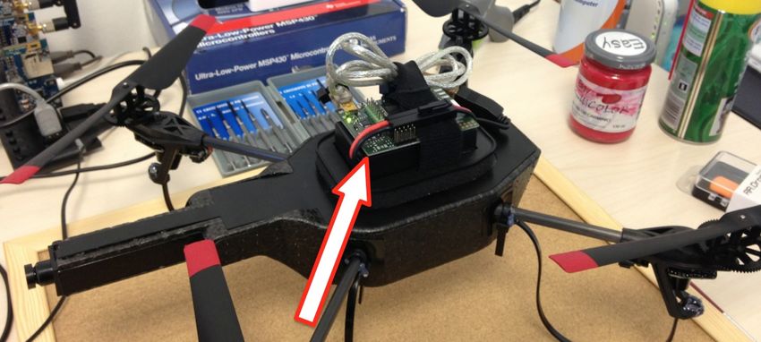
to explicitly deal with concurrency and parallelism, drone          variables enriched with spatial semantics. In addition, pro-
failures, navigational error, and the possibility of drones be-     grammers define time assertions to state temporal constraints
ing added or removed. These issues greatly complicate the           on sensed data that the run-time system must meet when
programming task.                                                   scheduling the drone operation. As described in Sec. 5, the
    On the other hand, swarm programming [11] explicitly            VOLTRON programming constructs can be translated to exe-
forbids shared or global state: all drones execute a single set     cutable code in mainstream languages.
of basic rules and operate only on their own local state. This          To concretely experiment with VOLTRON, we implement
approach is easy to program and trivial to scale up to multi-       a system prototype running on the AR.Drone 2.0 quadcopter
ple drones, but can only express emergent swarm properties          drones, as illustrated in Sec. 6. We choose the AR.Drone 2.0
such as dispersion or flocking; it cannot achieve tasks that re-    merely because it is both cheap and easily accessible, also
quire explicit drone coordination, such as sampling a sensor        when it comes to spare parts, which facilitates the experi-
at multiple locations simultaneously.                               mental activities. While the team-level programming model
    Contribution. We present a new drone programming                and its realization in VOLTRON remain independent of the
model called team-level programming, whose conceptual               specific type of drone—being it aerial, ground, or aquatic,
novelty lies in creating a middle-ground between drone-level        for example—our current implementation could be extended
and swarm programming. In team-level programming, users             to the latter platforms by swapping in the appropriate navi-
express sophisticated collaborative sensing tasks without re-       gation engine. On the other hand, the navigational tools for
sorting to individual addressing and without being exposed          aquatic and land-based drones are often not as market-ready
to the complexity of concurrent programming, parallel exe-          as the aerial drone ones.
cution, scaling, and failure recovery.                                  We report in Sec. 7 on the evaluation of VOLTRON based
    The basic approach is to allow the user to define the set of    on three representative applications: aerial photogramme-
sensing tasks that must be completed, subject to constraints        try [33], building 3D maps of pollution concentration, and
in space and time. Under the hood, the “team” run-time sys-         aerial surveillance. We perform a user study with 24 junior
tem automatically chooses the actions for each drone that           programmers to compare drone-level, swarm, and team-level
will collaboratively accomplish the sensing tasks. Because          programming. The results indicate that the latter is the only
the “team” does not choose individual drone actions until           method that allows junior programmers to create both cor-
run-time, the system can easily scale to an arbitrary num-          rect and complete collaborative drone programs. Their opin-
ber of drones without requiring code modifications. It can          ions, collected through a dedicated questionnaire, also point
also automatically adapt the execution plan as drones crash         to the ease of use of VOLTRON compared to the alternatives.
or deviate from their flight paths, perhaps due to obstacles or     We also implement all three applications using drone-level,
environmental effects, such as wind or water currents.              swarm, and team-level programming. We evaluate their per-
    The main benefits of this approach are enabled by the fact      formance using real-world experiments and an emulation
that the user only specifies the sensing tasks without express-     testbed that can scale up to 100 drones. Our analysis indi-
ing the details of how individual drones execute the tasks;         cates that VOLTRON produces marginal overhead in terms of
these details are chosen by the run-time system. However,           CPU, memory, and network utilization, while transparently
this is also the source of the approach’s main limitation:          and dynamically scaling to different numbers of drones.
since the user cannot address individual drones, she can-               Finally, using our prototype we perform a real deploy-
not express actions that involve direct interactions between        ment of aerial photogrammetry [33] at a 32,000 m2 archaeo-
drones, such as those to pass a ball between drones [43].           logical site in Aquileia (Italy), as we describe in Sec. 8. The
    The team-level abstraction is thus most suitable for col-       team of drones was able to produce maps of the site with
laboratively achieving a set of independent actions that            distortion levels within 3.3% by dynamically adapting to the
could, in principle, be achieved even by a single drone, but        number of drones, changing sunlight levels and cloud move-
for constraints on battery life, speed, and sensing range are       ments, and varying wind forces from 0-8 knots. In terms of
more effectively achieved by deploying multiple drones. We          scaling, it automatically decreased total execution time by 3-
argue that this is a useful layer of abstraction because the vast   3.5x as it ran with 1 drone to 7 drones, completing the task
majority of mobile sensing applications where drones may            in a fraction of the time needed by current practices.
be employed fall in this category. We return to this subject        2   Background & Related Work
in Sec. 2 when we contrast our work with the state of the art,         Mobile sensing is quickly expanding to a diverse set of
and in Sec. 3 where we describe a representative application.       applications and platforms. Popular examples are found in
    To explore the concept of team-level programming, we            applications that leverage the mobility of phones [23] and
create a programming system called VOLTRON, described               vehicles [27], or in scenarios where sensors are hooked to
in Sec. 4. In contrast to most distributed systems where            entities that move autonomously, such as animals [29, 38].
communication is the parallism bottleneck, the bottleneck           A characteristic common to these examples is the fact that
in collaborative drone applications is physical navigation.         sensor movements are outside of the programmers’ control.
VOLTRON offers several programming constructs to offer the          These instruct the devices to sample sensor data in an oppor-
illusion of a simple sequential execution model while still         tunistic manner, while mobility can only be passively moni-
maximizing opportunities to dynamically re-task drones to           tored by the application. Several systems aim at simplifying
meet programmer-provided spatio/temporal constraints. The           programming in these scenarios [23, 25, 29]. When using
constructs include a notion of abstract drone used as a sin-        autonomous drones, on the other hand, a device mobility be-
gle entry-point to the functionality of the entire team, and        comes part of the application logic, and must be explicitly
encoded. This requires to address completely different chal- Compared to macroprogramming sensor networks, our
lenges, such as how to specify the device movements and work considers a form of mobility that existing systems do
how to split the sensing tasks among multiple devices sub- not typically address [31]. This impacts both the program-
ject to spatio/temporal constraints. ming model and the distributed execution. As for the for-
The landscape of current drone platforms is a diverse one. mer, being a drone’s movements part of the application logic,
Existing devices often contain quite powerful computing re- they need to be explicitly encoded rather than passively ob-
sources. Many inexpensive ($200 to 1K$) platforms today served, as it happens in many mobile sensor network appli-
are built around variants of the PX4 autopilot boards [39], cations [29]. In addition, the use of location information
which applies to aerial, ground, and aquatic drones. These is not limited to reconstruct environmental phenomena [34],
platforms typically feature ARM Cortex MCUs with FPU but are used to proactively instruct the system on where the
acceleration and megabytes of RAM, combined with high- sensing operation must take place.
speed networking via WiFi or cellular. Although a signif- On the other hand, during execution, communication
icant part of the computing power is consumed by the au- among drones may happen in real-time rather than in a delay-
topilot functionality, the remaining capacity can be used for tolerant manner [47]. Moreover, the run-time system needs
application-level functionality via a POSIX-like RTOS. to consider each drone individually instead of treating all
The dominant practice in programming drones is to cre- sensor nodes equally because each drone requires individ-
ate a set of pre-defined commands combined into a single ual, but coordinated path planning. Finally, dealing with
script and programmed onto each drone. For example, the parallelism and concurrency is markedly different. In main-
ground drone iRobot Create [22] offers a low-level inter- stream sensor networks, it is network communication and
face to control the drone movements with bindings avail- input/output operations that need to occur in parallel with
able for several programming systems such as Player [21]. data processing. In our context, it is the drones’ movements,
Based on this, software packages are built to offer basic func- combined with the inherent unpredictability of the naviga-
tionality such as waypoint navigation [24, 36]. However, tion time, that makes the concurrency problem complex.
this approach quickly becomes unmanageable as the number Finally, in the specific field of aerial drones, demonstra-
of simultaneously-deployed drones increases. Programmers tions exist that do show drones performing sophisticated col-
must manually decompose the goal into a set of single-drone laborative tasks, but only for a handful of one-off applica-
parallel tasks. Moreover, to fully exploit parallelism, they tions created by skilled developers. For example, collaborat-
must estimate the duration of each task and balance the load ing quadcopters are able to throw and catch balls [43] and
between drones, while taking temporal constraints into ac- carry large payloads [30]. In these settings, a centralized
count. This analysis is complicated because the timing of computer system communicates with the drones 100 times
a drone’s actions depends on unpredictable factors, such as per second or more, and the goal is mainly to explore new
obstacles and crashes. approaches for mechanical motion control. The code to ex-
Real-time communication among drones can be used to ecute these tasks is indeed written by experts and custom-
collaboratively adapt and respond to these conditions. Inter- tailored to the specific application from the low-level drone
robot communication libraries do exist [28, 42], but moving control up to the necessary inter-drone coordination.
from independent parallel operation to system-wide coordi- 3 Example Application
nation is also difficult, because it requires parallel program- In contrast to existing literature, in this work we provide
ming mechanisms such as data sharing, synchronization, and a generic coordination substrate usable as-is for a large set
deadlock avoidance. As a result, most drone applications to- of multi-drone applications. These generally show some dis-
day use only a small number of drones at a time even when tinctive traits: i) they require the drones to sample the en-
more drones would improve performance, or evaluate larger- vironment subject to variable spatio/temporal constraints; ii)
scale cooperative strategies only in simulation [12, 40]. the workload, which in principle only one device may carry
Differently, in robot swarms, the drones operate only on out, can be split among multiple drones; iii) as a result, the
node-local state [11, 28]. In these systems, the programmers’ total execution time can be reduced by deploying additional
commands are translated into a sequence of primitive in- drones; and iv) direct interactions between drones that would
structions deployed onto all drones. Simple drone behaviors require individual addressing are not needed. In scenarios
are shown to produce emergent swarm properties, such as with these characteristics, our work spares much of the ef-
dispersion or flocking, but cannot achieve tasks that require fort required by building upon the low-level drone APIs, and
explicit coordination, such as sampling a sensor at different automatically and transparently manages parallelism as the
locations within time constraints. Several programming sys- number of drones is scaled up or down.
tems are applicable in this area. The Robot Operating Sys- An illustrative example is that of aerial mapping of ar-
tem (ROS) [42] provides a Publish/Subscribe coordination chaeological sites using photogrammetry techniques [33].
layer for decentralized computations; Karma [17] lets pro- Aerial drones are increasingly employed in these scenarios
grammers specify modes of operation for the swarm, such because physically walking on or near the site can cause ir-
as “Monitor” or “Pollinate”; and Proto [6] lets programmers reparable damage. In this field, we are collaborating with
specify actions in space and time. Meld [4] provides simi- archaeologists at the university of Trieste (Italy) to survey a
lar concepts for modular robotics. In contrast to reasoning site called Domus dei Putti Danzanti [19]. The 32,000 m2
in terms of decentralized computations based on local states, area, partly shown in Fig. 1, hosts the ruins of an ancient
we wish to provide a holistic perspective that allows to ex- Roman house dating to the fourth century BC. The excava-
plicitly encode actions for the entire ensemble of drones. tions are bringing back to life the layout of the house and its4 Programming Constructs
We describe the design of VOLTRON: a set of program-
ming constructs to explore the notion of team-level drone
programming. In a nutshell, we introduce: i) a notion of
abstract drone that allows the code to remain unchanged in-
dependent of the number of deployed drones; ii) spatial se-
mantics for variables and a foreachlocation loop to
enable parallel and independent actions to be requested for
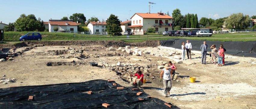
Figure 1. Domus dei Putti Danzanti archaeological site in a given set of locations; iii) a custom system of futures and
Aquileia (Italy)—NE corner. promises [20] to facilitate dynamic (re)scheduling of drone
operation; and iv) time assertions to state constraints on
sensed data.
surroundings. Archaeologists rely on this information to re- Unlike sensor network macroprogramming, the notions
construct the social interactions of the era; for example, how i) and ii) above are required to explicitly encode the drone
the owners—conjectured to be wealthy businessmen—used movements as part of the application logic. Moreover, iii)
to treat their servants. This can be determined by conjectur- is required because, in contrast to other kinds of distributed
ing about the usage of the different spaces in a house based computing, the drone movements represent the main fac-
on shape and size. tor potentially hampering parallelism. Finally, iv) allows
We use VOLTRON to support this study and present the programmers to declaratively control the time evolution of
results as part of our deployment experience. Specifically, to drone operations, which is typically not required in other
provide the geometric layout of the Domus dei Putti Dan- kinds of mobile sensing.
zanti, we use a team of aerial drones to derive orthopho- We use the application from Sec. 3 for illustration, but the
tos of the site [35]. An orthophoto is an aerial photo that abstractions are more generally applicable. In Sec. 7, we
is geometrically-corrected so that distances between pixels describe several other applications that we implement with
are proportional to true distances, such that the photo can be VOLTRON. Our design assumes that: i) drones have access
used as a map. A series of small aerial pictures is stitched to their own location; for example, from an on-board GPS
together to derive a single orthophoto by correcting for dis- module; ii) drones have access to a common time base; for
tortion effects [35]. The resulting accuracy is mainly deter- example, through a time synchronization protocol; and iii)
mined by the amount of overlap between the single pictures. drones can wirelessly communicate with each other and with
any ground-station that might exist. The vast majority of ex-
Currently, drone operators run the orthophoto software isting drone platforms can or do meet these assumptions.
once a drone has completed a full scan of the area [33]. If
the individual pictures do not have sufficient overlap, how- 4.1 Abstract Drone
ever, the resulting orthophoto will show excessive aberra- We define an abstract device with custom APIs that pro-
tions. The drone is then sent out again to gather pictures grammers can use to task the drones without individual ad-
at a finer granularity. The more pictures a drone needs to ac- dressing. This device is called Drones. As the abstract
quire, the more time it takes to complete the full scan. At the drone is the only entry point to the system’s functionality, an
same time, the scan must be completed within a limited time application’s code can remain unaltered no matter how many
because the scene may change; for example, due to varying real devices are deployed.
lighting conditions caused by shadows or moving clouds. If Fig. 2 shows the API of the abstract drone. It mainly of-
the time lag between any two pictures is excessive, the infor- fers a do command that accepts as inputs: i) the name of
mation will be inconsistent and will affect the accuracy. an action; for example, "pic" to take a picture; ii) a set
of physical locations where to perform the action; for ex-
Archaeologists thus need a simple way to program a team ample, the points of a (possibly time-varying) spatial grid;
of drones to scan an area, to continuously evaluate the aber- iii) optional parameters to customize the execution; for ex-
ration levels of the orthophoto based on the obtained over- ample, what sensor the drone needs to use to carry out ac-
lapping, and to accordingly adapt the drone operation at run- tion "pic"; and iv) a handle to retrieve a reference to the
time. The team of drones should automatically deal with executing action. Based on these inputs, the abstract drone
challenges such as wind and collisions among them. Also, transparently coordinates the real devices so that the given
if the archaeologists are unable to produce an adequate or- action is eventually performed at every input location. The
thophoto within the allowed time, they should be able to add abstract drone can achieve this as it sees fit; for example, if
more drones and the system will automatically re-balance the there are more locations than drones, it can freely schedule
scanning tasks to achieve a higher quality orthophoto. the drones to rotate through the different locations.
We choose this application as a running example because The output of the do command is a multiset of values of
the requirements for active sensing, scalability, and ease of the same data type, each representing the result of perform-
programming are representative of the applications we tar- ing the given action at a specific location. For example, the
get. Indeed, even though a single drone may carry out the en- output of performing action "pic" over a 3 x 3 x 3 grid is
tire scanning of the site subject to the above spatio-temporal eventually going to be a multiset of 27 values of type Image,
constraints, multiple coordinating drones may split the work each associated with a different location among the 27 in the
to reduce the execution time and/or obtain more accurate or- grid. The multi-set is progressively constructed as the drones
thophotos. perform the given action at the desired locations.Operation Inputs Description
1 spatial Image tiles ;
do action (singleton) Perform an action at specific 2 do {
/
locations (set 6= 0) locations, customized by 3 tilesOK = true ;
parameters (set) parameters, linked to 4 tiles@grid =Drones.do(" pic ",Drones.cam , handleCam );
handle (singleton) handle. 5 foreachlocation ( Location loc in tiles ){
stop handle (singleton) Stop the running action linked to 6 float aberr = abberationEstimate ( tiles@loc );
handle. 7 if ( aberr > MAX_ABR && ! sceneChanged ) {
set key (singleton) Set a hkey, valuei pair in the 8 Drones. stop ( handleCam );
value (singleton) registry. 9 int newStep = tune (Drones. get (" gridStep ") , aberr );
get key (singleton) Read the value of key from the reg- 10 Drones. set (" gridStep ", newStep );
istry. 11 tilesOK = false ;
Figure 2. Abstract drone API. 12 break;
13 }
14 }
The abstract drone additionally offers a stop operation 15 } while (! tilesOK );
to cancel previous do commands, and get/set operations
to read or write from a registry of hkey, valuei pairs that Figure 3. Adaptive sampling of aerial pictures for or-
stores application parameters and system information. The thophoto processing.
API is intentionally kept generic to be platform-independent.
We acknowledge that this design decision makes it harder to 1 boolean grid ( Location location ) {
2 if ( location .x % Drones. get (" gridStep ") ==0
manage heterogeneous systems of drones with different ca- 3 && location .y % Drones. get (" gridStep ") ==0)
pabilities or roles. Different teams can be separately con- 4 return true ;
trolled with independent abstract drones, but parallelism and 5 else return false ;
6 }
coordination between teams would be left to the program-
mer. This should still be easier than programming each drone Figure 4. Specification of a grid geometry. Location is
individually, and it remains an opportunity for future work. a built-in data type, customized depending on the specific
4.2 Reasoning with Space localization system.
The role taken by space information in VOLTRON is dif-
associated to the given specific location(s).
ferent than in other sensing scenarios. Indeed, location in-
The location(s) used as parameter for the @ operator can
formation are not opportunistically acquired and later used
be single locations or specified in a functional manner within
to process sensor data, but directly determine where the sen-
a finite coordinate system. Fig. 4 shows an example of the
sors are going to be sampled. Because of this, we give vari-
latter for the grid geometry. When executing an assign-
ables a spatial semantics both to specify where drones are to
ment with a space geometry, the system enumerates all pos-
move to sample the environment, and to encode the mapping
sible locations—based on a platform-specific unit metric—
between the results of actions and the associated locations.
and checks the return value of the space geometry for each
Spatial variables. Fig. 3 reports a fragment of VOLTRON of them. If this is true, the location is given as input to the
code implementing the core functionality in the archaeolog- abstract drone2 .
ical site application. The VOLTRON constructs are added as
Concurrency and loops. Calls to the abstract drone may
extensions to an existing “host” language, Java in this case.
simply be blocking. However, drone operations take time.
We discuss this choice in Sec. 7. The drones inspect the site
Moreover, as our application illustrates, the data the drones
at increasingly higher granularity based on an estimate of the
harvest rarely needs to be processed at once. For example, to
aberration in the resulting orthophoto. This is computed at
compute the expected aberration of the resulting orthophoto,
run-time using available orthophoto libraries [32]1 . we can process the pictures as they come. Based on this,
Line 1 in Fig. 3 declares a spatial variable tiles whose programmers can dynamically adapt the grid granularity.
data type is Image. The spatial qualifier indicates that To enable higher concurrency between drone operations
the variable can store one or more Image values each as- and data processing, one may straightforwardly employ par-
sociated to a different location. These values are going to allel threads with proper synchronization. However, parallel
be the individual aerial pictures that we eventually assemble programming is challenging in general and, as we demon-
in a single orthophoto. Generally, spatial information act as strate in Sec. 7, it likely leads to programming errors in our
an additional facet in variable declarations, orthogonal to the context. Based on this, to enable higher concurrency and
data type. This allows VOLTRON to retain the type system of yet retain the sequential semantics programmers are most
the host language. familiar with, we adopt a custom system of futures and
Lines 2 to 15 implement the active sensing loop. Line 4 promises [7, 20] for spatial variables.
assigns to tiles the spatially-associated values resulting Whenever a spatial variable is assigned to the result of a
from the execution of the abstract drone over a set of loca- do() operation, we create a future for every location even-
tions arranged as a grid of a given granularity. The action tually holding the action’s result. The future acts as a “place-
is to take a picture at every input location. The grid is input holder” waiting for the drones to provide the concrete value,
to the abstract drone to specify where to carry out the action, that is, to “complete” the promise. Intuitively, the do() call
and is separately specified as explained next. The @ operator on line 4 in Fig. 3 creates a “grid of futures”, one for every
in variable assignments thus only permits the write of values
2 The format of location information is, in general, platform specific, and
1 These kind of estimations do not require to compose the actual or- here specified as hx, yi coordinates merely for simplicity. The system also
thophoto, and so are generally sufficiently lightweight to run also on em- allows one to configure a tolerance margin whereby a location is considered
bedded platforms. reached anyways.location that function grid in Fig. 4 considers. This allows 1 time_assert maxLag (spatial Image tiles ) {
the execution to continue until the value becomes necessary. 2 forall locA : Location in tiles ,
3 forall locB : Location in tiles |
Only then, the execution blocks waiting for the promise. 4 Math . abs (T? tiles@locA - T? tiles@locB ) >10 MIN
We complement this design with a custom 5 on violate { sceneChanged = true ; }
foreachlocation loop that allows the program- 6 }
mer to iterate over the results of the abstract drone as they
Figure 5. Time assertion to stop adapting the grid gran-
come, using the associated locations as an index, as in line 5
ularity if the scene should be considered as changed.
of Fig. 3. A foreachlocation loop can process the data
independently of the order these data is stored in memory. 4.3 Reasoning with Time
Specifically, whenever concrete values are available in a Many drone applications are time-sensitive, especially
spatial variable, the loop iterates over those locations first. when the data the drones harvest need to be obtained within
The loop blocks when every concrete value is already given temporal bounds, as in our example application. This
processed, but more futures are set for the spatial variable. contrasts other kinds of mobile sensing where the processing
It then unblocks as some of these futures are replaced by the is often delay-tolerant. VOLTRON deals with such require-
corresponding promises, until no more futures are set. ments by giving programmers ways to express time asser-
In Fig. 3, the foreachlocation in line 5 likely blocks tions. We opt for a declarative approach in that the temporal
initially until the first pictures arrive. As this happens, the requirements at stake are most naturally expressed this way,
loop unblocks. Next, we pass the obtained pictures to an or- and yet it is practically possible to transform such declarative
thophoto library to compute the estimate of the final aber- specifications in the necessary procedural code.
ration. The execution proceeds differently depending on In our example application, should the time interval be-
whether the estimate exceeds a predefined threshold and tween any two pictures cross a threshold, programmers must
the scene has hitherto not changed (line 7). The latter re- consider the scene as changed and stop adapting the grid
quirement is a function of temporal aspects; we illustrate in granularity. It is now more important to complete the inspec-
Sec. 4.3 how we check this situation. If either of the condi- tion, because the changes in the scene will anyways mainly
tions is not met, the loop rewinds until it blocks again waiting affect the accuracy of the resulting orthophoto. The spec-
for the drones to provide more pictures. ification in Fig. 5 implements the relevant time constraint.
Differently, we stop the abstract drone (line 8), adapt the Programmers access temporal information via a T? operator
grid granularity based on current step and expected aberra- to state the actual constraint in line 4. The fragment of code
tion (line 9 and 10) and set a flag (line 11) that causes the ab- within the on violate (line 5) clause is executed as soon
stract drone to reschedule operations with the new grid. We as a violation to the time assertion is detected.
intentionally do not reinitialize the tiles variable. Some VOLTRON time assertions are, in essence, predicates de-
locations in the new grid might be the same as in the ear- fined over the timestamps of at least one quantified spatial
lier one. The abstract drone may not need to re-do the variable. Thus, their general form is:
work for those locations. By not re-initializing the variable,
(forall | exists) location_name : Location
the abstract drone finds some already-completed promises in in spatial_variable_name
tiles that it can simply skip. ( ,(forall | exists) location_name : Location
in spatial_variable_name )+ |
Uncompleted promises. Drones are failure-prone [13]. time_predicate
Moreover, even a fully-functional system may trivially fail on violate {\\...}
because of environment constraints; for example, obstacles
preventing the drones to reach the desired locations. These which arguably covers most of the expected temporal re-
situations entail that the drones may be unable to complete quirements in the applications we target.
some promises, eventually bringing the execution to a halt. The assertions may refer to arbitrary spatial variables
To cope with these situations, we provide an await con- identified based on their name. The parameter tiles in
struct to unblock waiting for a promise, as in: line 1 of Fig. 5 refers to a variable with this name visible from
where the time assertion is defined. Our translator converts
foreachlocation ( Location loc the time assertions in a side effect-free functional equivalent,
in tiles await 10 MIN ){//...}
scheduled in parallel with the main program. In addition,
where the execution blocks at the loop for at most ten min- it reserves a special handling to time assertions whenever
utes before continuing anyways. Should the timeout fire be- they can be considered to further optimize the drones’ move-
fore the drones complete any of the promises in tiles, ments, as we describe in Sec. 6.
the loop unblocks anyways. Programmers can determine Programmers can use the T? operator also outside of time
whether the timeout fired for a future, or simply a future at assertions. For example, in the application of Sec. 3, we use
a given location does not exist, using the isfuture key- it to compute the average time elapsed between consecutive
word, as in: pictures, useful to obtain a run-time estimate of the total ex-
ecution time.
if (isfuture tiles@arbitraryLoc )
System . out . println (" The timeout fired ."); 5 Compile-time Code Translation
else if ( tiles@arbitraryLoc == null)
System . out . println (" No future at " + arbitraryLoc ); We implement two source-to-source translators for
VOLTRON programs, using Java or C++ as host language.
Note that programmer can attach the await constructs to Both translators convert VOLTRON code into programs writ-
any read operation of spatial variables. ten solely in the host language. These are handed over tostandard tool-chains for compilation.
Both translators are based on ANTLR and proceed the
same way. First, they parse the input program to con-
struct an abstract syntax tree (AST). Next, some nodes in
the AST are converted using predefined translation rules.
These procedures happen off-line and automatically. We
define translation rules for every constructs we hitherto in-
troduced. These are, in most cases, straightforward. Due
to the impact they have on concurrency semantics, however, Figure 6. Custom AR.Drone with auxiliary embedded
we briefly illustrate the translation for spatial variables and board.
foreachlocation loops.
Spatial variables. We convert every spatial variable into a 6 Run-time System
collection of structured data types. One instance of the struc- The run-time performance of teams of drones is mostly
ture includes a field of the original data type; for example, of determined by their execution time, that is, how much time
type Image for the tiles variable in Fig. 3. It additionally it takes to complete the assigned tasks. Due to energy is-
includes a Location field representing the associated lo- sues, the quicker a drone can complete a task, the fewer bat-
cation, a flag indicating whether the variable holds a future, tery changes are needed, and thus the system becomes more
and an identifier pointing to the corresponding promise. practical.
Every instance of these structured data types is inserted Rationale. In VOLTRON, the implementation of the abstract
in a shared data repository that mediates read and write op- drone encapsulates the mechanisms to drive the real devices.
erations to spatial variables. Whenever the original program Crucially, we must determine the drones’ movements at run-
requires to read a spatial variable, the data repository looks time. Off-line approaches whereby the sensing locations are
up the specific value based on variable name and location. divided beforehand among the available drones are unlikely
If the value is still a future, the read operation on the data to be sufficiently general and/or to work efficiently, as the
repository blocks. a priori knowledge of the sensing locations may be limited.
We translate every call to do() on the abstract drone to For example, it is generally impossible to pre-compute all
a specific sequence of operations. In case of a space geom- locations returned by space geometries, as some information
etry, the locations of interest are first collected by repeat- may only be available at run-time.
edly querying its functional specification, such as grid in Perhaps the only general solution in this respect might be
Fig. 4. Next, the locations are input to the abstract drone to split the field in non-overlapping sub-areas, and to assign
with the indication of the actions to take. Whenever the ab- all sensing tasks in a sub-area to a given drone. However, in
stract drone completes a promise, we write the value to the general one cannot predict how such subsets of tasks would
shared data repository and every blocked process is sched- evolve based on sensed data. For example, sensor readings in
uled again. This allows the original program to unblock on one sub-area may cause the assigned drone to perform much
a previous read operation. An exception to this processing more work than all others, leading to a non-optimal usage of
occurs when a future can be directly transferred to another resources.
spatial variable, as it happens in an assignment between spa- Differently, using our prototypes, we achieve a form of
tial variables. In this case, we can copy the future to the inter-drone coordination that continuously balances the work
assigned variable and continue. among the available drones, adapting to the changes in the
Loops with foreachlocation. To provide the seman- program state and to the dynamics of the environment. We
tics described in Sec. 4.2, the order of visit of data refer- do so in a centralized or state-replicated manner, as we de-
enced in the loop condition matters. In the example of Fig. 3, scribe next, with no changes required to the VOLTRON pro-
depending on the order the foreachlocation loop in- gram in case it is to run using either execution model.
spects the locations for variable tiles in the data repos- Target platform. We implement two prototypes in Java and
itory, a read operation may block immediately on a future C++, targeting customized AR.Drone 2.0 quadcopters [37],
although concrete values exist somewhere else in the same shown in Fig. 6. The AR.Drone is a cheap commercially-
collection. available quadcopter, equipped with an ARM Cortex A8
To address this issue, the read operations of spatial vari- CPU, 128 Mb of RAM, a WiFi interface, two cameras, and a
ables in a foreachlocation loop are translated into range of sensors for navigation. It runs an embedded version
a form of “conditionally-blocking” read through a circular of Linux and comes with its own libraries for remote con-
buffer. Rather than blocking on the first future encountered, trol. The team-level programming model and the language
a read operation skips every future in the collection until it constructs of VOLTRON are independent of the specific type
finds a concrete value yet to process. Conversely, the opera- of drone and may be applied to other kinds of drones, such as
tion blocks if every concrete value is already processed and ground or aquatic ones, by replacing the navigation engine.
more futures are set in the same collection. At this point, the We choose the aerial drones because, among existing drone
first promise that completes on this collection unblocks the platforms, they arguably are the most-market ready, and are
process, and processing resumes from the value just written3 . instrumental to the deployment effort we describe in Sec. 3.
We customize the AR.Drone by shaving off unnecessary
3 Note that this implementation does not protect from concurrent modifi-
cations of other processes. As in standard Java, we expect programmers to take care of these situations explicitly.payload, by adding another vertical camera, by replacing reasonably in practice [9], and randomly split the input loca-
the battery with a higher-density one, and by interfacing an tions in as many subsets as the number of drones. In the ab-
additional embedded board, shown in Fig. 6 mounted atop sence of further information, a random split is probably the
the drone. The board features an MSP430 MCU and an only choice that evenly distributes the “unlucky” locations.
802.15.4-compliant 2.4 Ghz CC2420 low-power radio. We We solve the single TSP problems using the nearest
use this board for integrating a LocoSys LS20031 GPS re- neighbor greedy algorithm [9]. Next, we approximately eval-
ceiver (not shown) and for communication among drones. uate each drone’s traveling time based on distances between
6.1 Centralized Execution locations, the drone maximum speed, and the expected time
A ground-station connected to the drones via WiFi cen- for carrying out the action at every location. Provided a
trally executes the VOLTRON program and stores the cor- drone completes a promise at every location, we check every
responding data repository. Hence, the drones store no ap- relevant time assertion. In case of violations, we discard this
plication state, and every read/write operation happens at a solution to the MTSP problem, and the process starts over
single copy of the data. The ground-station orchestrates the with a different random division of the input locations. When
drone’s movements using platform-specific libraries for re- a maximum number of iterations is reached, the program-
mote control [2]. The drones report their GPS location to the mer is notified that the system cannot find a navigation plan
ground-station. Based on this and the inputs to the abstract compliant with the time assertion. The programmer can then
drone, the ground-station decides how to move the drones. decide to interrupt the execution or to continue anyways.
Centralized executions are likely to be very efficient in Navigation. Once the navigation plan is determined for
terms of execution time, in that the ground-station deter- each drone, their concrete movements are driven by the Pa-
mines the drones’ movements based on global knowledge. parazzi [36] autopilot, running on the ground-station along-
On the other hand, the ground-station requires constant WiFi side the VOLTRON program. Potential collisions between
connectivity with the drones, which prevents them to oper- drones are recognized at the ground-station based on the
ate outside of the ground-station WiFi range. Moreover, the drones’ positions. The ground-station prevents the collision
ground-station is a single point of failure. by moving every drone only when at a safe distance to any
Despite these limitations, the centralized approach is use- other drone, or by making a drone hover until the surround-
ful in practice, as we discuss in Sec. 8, which illustrates ings are clear. We need to perform these checks at run-time,
our real-world experiences. Indeed, if needed, extending because merely identifying trajectory intersections does not
the ground-station WiFi range is practically quite simple: a suffice: the drones may unpredictably drift off the expected
cheap amplified directional antenna is sufficient to reach an trajectories because of environmental phenomena such as
AR.Drone more than 1 km away. Most importantly, being wind gusts.
the fastest to execute, centralized executions require the least
number of battery changes, as we show in Sec. 7, rendering 6.2 State-replicated Execution
the whole system much more practical. To remove the single point of failure, every drone inde-
Drone orchestration First, we must plan the drone move- pendently executes a separate copy of the program. To over-
ments w.r.t. each other. We must do so whenever a new come the limitations of 1-hop WiFi connectivity, every drone
do() call occurs, while also considering currently execut- directly communicates with others via the CC2420 radio,
ing do() calls that may have not completed. As this occurs possibly across multiple hops, extending the overall range of
at run-time, we need a mechanism that quickly returns a so- operation. Compared to centralized executions, these advan-
lution, although sub-optimal. tages come at the price of sub-optimal decisions about the
We map the problem to a multiple traveling salesman drones’ movements, as each of them autonomously decides
problem (MTSP) [9], which generalizes the TSP in case of a where to move.
finite number of salesmen (drones). This requires identifying State consistency. In this setting, the data repository is
a heuristic to split the input locations among the drones, then also replicated across the drones, and an obvious consis-
considering each subset of locations as input to a smaller tency problem arises: different drones may complete dif-
TSP whose objective is the minimization of the traveled dis- ferent promises at different times, so the program execution
tance. For aerial drones, this is largely proportional to the may differ across drones.
execution time. We employ a virtual synchrony replication model [10] to
To split the target locations, one may apply some form ensure that every copy of the program proceeds between the
of geographic balancing. For example, we may assign ev- same sequence of states, and thus eventually produces the
ery drone to a subset of nearby locations. However, such a same output. Virtual synchrony is used for building repli-
solution works efficiently only as long as the different sub- cated systems by totally ordering the inputs to different repli-
sets of locations can be covered in roughly equal time. This cas. If the replicas behave deterministically, this ensures con-
does not hold in general, because the environment may affect sistency of their outputs. Moreover, virtual synchrony can
given portions of space more than others; for example, when also deal with node failures, allowing the system to safely
an area is more exposed to the wind. If a drone is assigned resume from failures occurring to some of the replicas.
such an “unlucky” portion of space, it may take longer to Virtual synchrony ensures state consistency in our setting
operate, while all other drones may have completed earlier based on the observation that the only inputs to VOLTRON
and remain idle, again resulting in a non-optimal resource programs are the promises. Therefore, ensuring totally or-
usage. This makes this kind of solution not sufficiently gen- dered updates to the shared data repository suffices to pro-
eral. Therefore, we apply a different heuristic proven to work vide program consistency. When executing in this manner,-40
Log-normal path loss model 7 Evaluation
-50 Real measurements
We evaluate VOLTRON in four different ways. In Sec. 7.2,
RSSI (dBm)
-60
we measure VOLTRON’s run-time performance in real-world
-70
experiments to quantify its scalability in centralized and
-80
state-replicated executions. Sec. 7.3 reports the results of a
-90
user study involving 24 junior programmers, which demon-
-100
4 6 8 10 12 14 16
strates that VOLTRON eases the implementation of active
Distance (m) sensing applications using multiple drones. Sec. 7.4 quanti-
tatively corroborates this claim by evaluating the implemen-
Figure 7. In the archaeological site, the CC2420 RSSI tations based on established software metrics. In Sec. 7.5, we
tends to follow the log-normal path loss model when evaluate the cost of using VOLTRON in terms of system over-
drones are in flight. head in a large-scale emulated environment, and demonstrate
that it does not appreciably impact the overall scalability.
calls to the data repository are negotiated by a virtual syn-
chrony component. This component tags every call with a 7.1 Methodology
totally ordered sequence number. The operations are then Applications. We evaluate VOLTRON using three represen-
executed according to their sequence number. tative applications. The first is the archaeological site appli-
Supporting virtual synchrony in a highly mobile network cation described in Sec. 3, which we call ARCH.
is a challenge per se, and even more so in multi-hop net- The second application, called PM10 , deals with building
works. We tackle these issues by using Virtus [18]: a virtual 3D maps of pollution concentration in the atmosphere [45].
synchrony layer recently developed for 802.15.4-compatible The execution starts with a call to the abstract drone to sam-
2.4 Ghz radios. Virtus efficiently works across multiple hops ple this quantity along a predefined 3D grid. As this happens,
while not relying on any topology information; hence, it is we build a spatial profile of pollution concentration and pro-
apt to operate in such highly mobile environment. gressively compute gradients towards areas of higher con-
Coordinated navigation. Running the MTSP solver on the centration. A second call to the abstract drone dispatches
drones might not scale. We thus employ a simplified ver- some of the drones to sample the pollution concentration
sion of an existing multi-robot exploration algorithm [44]. along such gradients, enriching the spatial profile. The run-
In a nutshell, the algorithm drives the drones by creating time system takes care of transparently allocating the avail-
a virtual potential field where the target locations are min- able drones between the two concurrently-executing calls.
ima. Every drone autonomously moves towards the closest Moreover, for the obtained spatial profile to be consistent,
minima—identified by its GPS coordinates—by descending we must gather any two consecutive samples within a given
the corresponding gradient. It might then happen that two time bound, which we express as a time assertion. In case of
or more drones decide to reach the same minima. When the violations, the system adapts the sensor parameters to speed
target location is reached, the minima is cleared. Updates to up the execution.
the virtual potential field are also propagated using Virtus, The third application, named PURSUE, is representative
although total ordering for these is not mandatory: stale in- of surveillance applications [46]. The drones are to find and
formation may degrade performance; for example, whenever follow moving objects by providing an aerial picture of them
a drone moves towards an already cleared minima, but they whenever they first enter the camera field. The objects may
do not affect overall consistency. appear or disappear unpredictably. Where to find an object
To prevent collisions, every drone creates virtual repul- is determined by sensor readings. The program includes two
sion forces communicated to other drones using 1-hop bea- distinct operating modes. When in “patrolling” mode, the
coning from the CC2420 radio, so that far away drones are a drones regularly inspect a predefined portion of space. When
priori excluded from processing. We deem the strength of the an object is found, some of the drones switch to “pursuing”
repulsion force proportional to the received signal strength mode. In our setup, the objects may move faster than the
indicator (RSSI) returned by the CC2420 radio, Because the drones. This entails that not any single drone can constantly
drones stay away from ground, in the absence of obstacles follow an object, but the abstract drone needs to dynamically
and interference, the RSSI tends to follow known theoretical switch between the real drones to ensure an object is con-
models. Fig. 7 exemplifies this based on micro-benchmarks stantly tracked. Time assertions are defined to ensure that
in our archaeological site, calibrating the log-normal path drones meet a temporal upper bound between the detection
loss model using linear regression. of a moving object and when its picture is taken. In case
The implementation of the navigation algorithm runs on of violations, every tracked object with at least one acquired
the AR.Drone main board next to the VOLTRON program, picture is released from tracking to re-gain resources, lower-
interfacing directly with the AR.Drone firmware to issue the ing the acquisition latency for the next object.
necessary flight commands and with the auxiliary board for Baselines. We compare VOLTRON with three baselines: i)
communication with other drones. Our implementation is drone-level programming, ii) swarm programming, and iii) a
thus somewhat tailored to our custom hardware. However, library-based version of VOLTRON. To perform the compar-
many commercially-available drones are based on ARM isons, we implement functionally-equivalent versions of our
platforms, as we mentioned in Sec. 2, while integrating the applications using the three systems described below.
auxiliary board on a good fraction of them should be straight- We use the AR.Drone SDK as a representative of drone-
forward: a serial connection is all that is needed. level programming. Programs written with the AR.DroneSDK must be executed on the ground-station and remotely 100
Centralized
Execution time (min)
control the drones. We implement the planning of the 80 State-replicated
drones’ movements using the same centralized planning al-
60
gorithm described in Sec. 6.1.
We use ROS as a representative of swarm programming. 40
ROS is established software and was recently ported to the 20
AR.Drone [5]. The specific AR.Drone port does not sup- 0
port running all code on the drone itself; nonetheless, we 1 2 3 4 5 6 7
encode the robot actions based only on local state in accor- Number of drones
dance with the principles of swarm programming. We imple- Figure 8. Using multiple drones provides significant im-
ment the planning of the drones’ movements using the same provements in execution time.
distributed planning algorithm described in Sec. 6.2.
Finally, we create a new implementation of VOLTRON 5 Centralized
Application rounds
State-replicated
that uses standard libraries instead of extensions to a host 4
language. We call this implementation VOLTRON L IB. In 3
library form, the abstract drone takes as additional input a 2
reference to a listener object used to (asynchronously) pro-
1
cess the data as it arrives. Spatial data are stored in standard
collection objects. Programmers use concurrent threads to 0
1 2 3 4 5 6 7
parallelize data processing and drone operation, with stan- Number of drones
dard producer-consumer synchronization. Time assertions
Figure 9. Five drones are sufficient not to replace batter-
are specified in a procedural manner and manually scheduled
ies in centralized executions, seven drones are needed in
concurrently with other threads.
distributed executions.
In all three cases, when assessing the programming effort,
we exclude the implementation of the navigation functional- in centralized executions, by employing less conservative
ity from the analysis even though not all libraries fully pro- collision-avoidance mechanisms or smarter heuristics to split
vide it. This creates a worst-case setting for VOLTRON when the input locations among the drones [9]. However, the
it comes to comparing the different programming efforts. processing times in the latter may render them impractical
7.2 Real-world Experiments at run-time. We expect the execution times for the ROS
We conduct experiments for about one week at the archae- and AR.Drone SDK implementations to be comparable to
ological site to evaluate how the scanning speed changes as VOLTRON since they employ the same heuristic MTSP so-
the number of drones is increased. We compare both central- lution. We return in Sec. 8 to the the variability in execution
ized and state-replicated executions. time shown by the standard deviation in Fig. 8.
The same chart shows that, in general, state-replicated ex-
Setting and metrics. We run ARCH with one to seven ecutions take more than twice the time of centralized execu-
drones. We measure the application execution time, that tions. This is largely due to the sub-optimal choices of the
is, the time it takes for a given number of drones to gather exploration algorithm, and corresponds to the overhead for
enough pictures within the given time constraint so that the avoiding a single point of failure and extending the operating
resulting orthophoto is satisfactory. range. The decisions taken by the individual drones during
Whenever a given number of drones cannot complete the state-replicated execution are similar to those during central-
inspection before the battery dies, the drones come back to ized ones, as long as drones are far apart. When two drones
the starting point, we replace the batteries, and we let them with overlapping paths come close together, however, the
continue from where they left. In computing the execution (virtual) repulsion forces described in Sec. 6.2 take longer
time, we do not include the time for such battery replace- to resolve the path conflict.
ment. Nonetheless, we also count the number of times this We also observe a constant penalty for state-replicated
needs to happen as the number of application rounds. The executions vs. centralized ones, visible even with only one
drones move at a maximum speed of roughly 5 m/s. We re- drone. This appears because of two reasons: i) the ex-
peat each experiment 5 times, and plot averages and standard ploration algorithm we use in the former works in discrete
deviations. rounds: a drone moves for some time, stops to re-evaluate the
Results. Fig. 8 indicates that execution times are signifi- state of the virtual potential field, and then resumes move-
cantly reduced as the number of drones increases. In fact, ment; hence, drones move slower than in centralized exe-
only by deploying all seven drones in centralized executions cutions, where instead a drone heads directly to the desti-
can the 10-minute constraint in Fig. 5 always be satisfied, nation; and ii) the virtual synchrony layer may take some
even if by a narrow margin. The speed increases diminish time to recover lost packets [18]: this adds another source
as more drones are added, as other factors come into play: of latency, in that the exploration algorithm cannot resume
i) the time the drones “waste” hovering to avoid collisions movement until the state of the virtual potential field is up-
with other drones; and ii) the time necessary for inter-drone dated. In Fig. 8, this penalty is somehow dominating until
coordination, through either the ground-station or the virtual three drones are deployed, then part of it is amortized by the
synchrony layer. additional drones, but its influence still remains.
The diminishing returns could be ameliorated, at least Fig. 9 depicts the number of execution rounds in our ex-You can also read