Temporal and Spatial Use of the Skerries Bank Angling Zone by Shore-Based Anglers - September 2020
←
→
Page content transcription
If your browser does not render page correctly, please read the page content below
Temporal and Spatial Use of the
Skerries Bank Angling Zone by Shore-
           Based Anglers

     Sarah Curtin                Dr James Stewart
  Environment Officer        Senior Environment Officer

                    September 2020
Version control history
       Author                    Date                         Comment                                                 Version
     Sarah Curtin                                            Draft report                                               0.1
     Sarah Curtin           26/05/2020            Amendments after initial review by                                    0.2
                                                              J. Stewart
     Sarah Curtin            1/07/2020            Amendments following review by                                          0.3
                                                       S. Clark and J. Stewart
 James Stewart              07/09/2020              Review and edit of text and                                           1.0
  Sarah Clark               15/03/2021            analyses, re-plotting of figures for
                                                           finalised report

                                                            Contents

1.     Introduction ...................................................................................................................... 3
2.     Methodology .................................................................................................................... 6
3.     Results ............................................................................................................................. 7
     3.1.    Angling effort, location and seasonality .................................................................... 7
     3.2.    Target species .......................................................................................................... 8
     3.3.    Angler behaviour and knowledge ............................................................................. 8
4.     Discussion and Conclusions ............................................................................................ 9
References ............................................................................................................................ 11

                                                                      2
1. Introduction
Devon and Severn Inshore Fisheries and Conservation Authority (D&S IFCA) has a duty to
seek to balance the different needs of persons engaged in the exploitation of sea fisheries
resources in the District. Recreational Sea Angling (RSA) was one of three core work areas
in the D&S IFCA’s Annual Plans between 2012 and 2015. Following the publication of its first
Recreational Sea Angling Strategy, D&S IFCA was looking to introduce fisheries
management that would proactively develop the sector. Initial scoping of potential sites was
carried out with the assistance of the RSA representatives on the IFCA. Three potential pilot
study areas were identified to assess the impact of introducing management measures to
improve sea angling: the Emsstrom wreck site close to Torbay, the Skerries Bank in Start
Bay and Burnham, Berrow and Brean beaches in Somerset.
The Skerries Bank is a 6.5km sand and shell bank running underwater in a north east
direction from Start Point in South Devon. Skerries Bank lies within an area which was
designated as the Skerries Bank and Surrounds MCZ in 2013 (Fig. 1). The MCZ designation
includes various intertidal and sublittoral rock and sediment habitats as well as spiny lobster,
Palinurus elephas, and the pink sea fan, Eunicella verrucosa. The Skerries Bank also sits
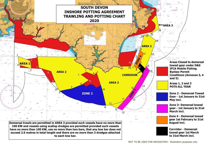
adjacent to the South Devon Inshore Potting Agreement area (Fig. 2), which introduced
voluntary closures to trawling from 1978 (Blyth et al., 2002), and management through
legislation was introduced in the late 1990s. The Skerries Bank itself lies within an area
which was closed to trawling under a Devon Sea Fisheries Committee Byelaw, which existed
for much of the 20th Century. The Skerries Bank/Start Bay closure to mobile demersal gear
is still in place today under D&S IFCA’s Mobile Fishing Permit Byelaw (Fig. 3).
Figure 1. Map of Skerries Bank and Surrounds MCZ.
3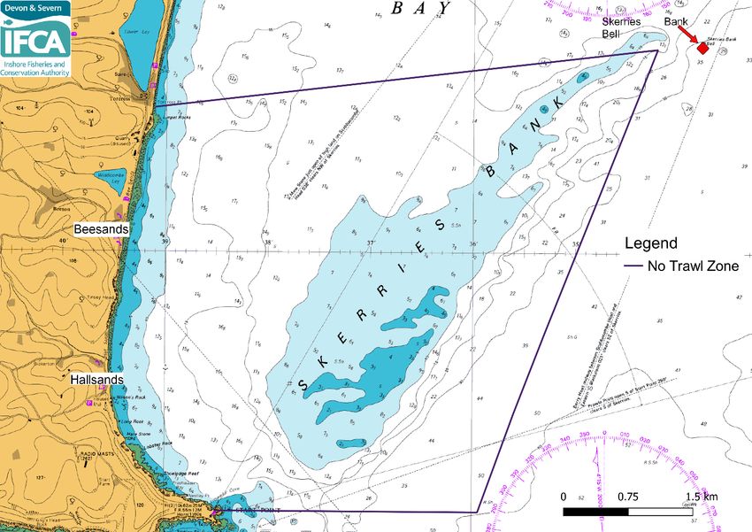
Figure 2. Map of the Inshore Potting Agreement areas

Figure 3. Map of Skerries Bank showing no-trawl zone, Beesands beach and Hallsands beach.

                                                4
The beaches of Beesands and Hallands (Fig. 3) are sheltered from prevailing south-westerly
winds and are close to the rich feeding grounds of the Skerries Bank, making them popular
spots for shore anglers. Plaice, Pleuronectes platessa, and blonde ray, Raja brachyura,
utilise the sand bank features of the Skerries Bank and are the primary species targeted by
the RSA sector. The area is also popular with private RSA boats and commercial fishers.
Angling surveys conducted by D&S IFCA, as part of its participation in the Sea Angling 2012
project, recorded a high density of private RSA angling boats in the Skerries Bank area.
Commercial fishing activities include fyke netting, potting, longlining and monofilament
netting, primarily from small vessels operating from Beesands, Hallsands and Dartmouth.
Anecdotal reports suggested recently increasing pressure from static net fisheries,
particularly for rays.

After an initial period of public consultation on a proposal to remove netting and longlining
from the Skerries Bank Angling Zone area, in July 2014, D&S IFCA’s Officers held three
workshops with stakeholders (one meeting per stakeholder group) in order to better
understand fishing activities relevant to the Skerries Bank. Recreational sea anglers, charter
boat operators and commercial fishermen, who fished from ports close to the site, were
invited to attend these sector-specific workshops. The first round of workshops focused on
each user group’s knowledge of the site, their fishing activities (including spatial and
temporal use of the Skerries) and their concerns and ambitions relating to the proposed
Angling Zone. From this first round of in-depth consultation, revised proposals were
compiled and sent to interested parties. A second round of workshops was held in late
August 2014 to give the sectors an opportunity to respond to the revised proposals before
officers formulated a final proposal and recommendations for D&S IFCA.

The workshops highlighted a great deal of consensus between the groups on how
management of an Angling Zone would improve their activities. The charter boat user group
felt that current static gear levels are not detrimental to their fishing activities. Although
concern was voiced by the RSA user group regarding current levels of netting, all three
groups saw an increase in current levels of static gear as undesirable and potentially
damaging. The workshops also highlighted the importance of the area primarily for plaice for
the charter boats, although rays were reported to add value to the area as a whole for this
sector. Rays and plaice were equally important to the RSA sector. The commercial catching
sector felt that they could agree to a complete ban on commercial targeting of plaice in the
Skerries Bank Angling Zone area in order to acknowledge the importance of this species to
recreational sea angling and charter boats. The commercial sector was concerned about the
removal of opportunities for ray fishing and longlining, as this would prove a significant risk to
their businesses. The commercial user group also felt that their ‘stewardship’ of the area,
with families fishing the area from small boats for generations, should be recognised; this
view was echoed by the charter boat sector. The commercial catching sector felt that, in
order to acknowledge their compromise in giving up the potential for plaice fishing, they
would like to see balance in management by the placing of sensible bag limits on
recreational anglers (including charter boats), in order to remove the risk to their business of
fish being caught by unlicensed vessels in the area being sold on the ‘grey market’. The
RSA sector saw the introduction of a bag limit as acceptable, providing the numbers were
not overly restrictive. Consensus could not be reached on an area free from all forms of
netting. The RSA sector felt that this was an important part of the original proposal and
therefore suggested the placement of smaller, more localised no-netting zones to benefit
shore anglers. In the second round of consultations, an area off Beesands beach was

                                                5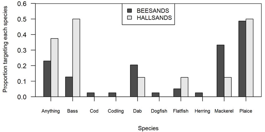
therefore proposed as no-netting. The commercial sector strongly rejected this area and
questioned the perception held by anglers that the current levels of commercial netting
activity in the vicinity of Beesands is sufficient to be detrimental to shore-based angling
activities. In the absence of evidence to guide decisions, the IFCA have therefore suggested
a reporting scheme for licensed boats to record commercial fishing activity within the Angling
Zone to guide future decisions. After the initial and subsequent workshops a voluntary Code
of Conduct was developed and the Skerries Bank Angling Zone was created, including the
following provisions:

     1. No commercial targeted fishing for plaice by any method may take place within the
        entire area of the Skerries Angling Zone.

     2. Vessels which exceed 10m in overall length are prohibited from engaging in any
        commercial or recreational netting or longlining activity within the entire area of the
        Skerries Angling Zone.

     3. All nets used within the pilot Angling Zone should be clearly marked using buoys with
        flags to aid efficient differentiation between pots and nets.

     4. There is a bag limit for recreational sea anglers fishing within the Angling Zone of 10
        plaice and 3 rays per angler, per day.

The Code aims to balance the needs of all three user groups by restricting commercial
netting and longlining effort to preserve the importance of the area to recreational anglers
and charter boats, whilst maintaining access for small commercial fishing vessels that rely
on access to the area.

In order to supplement anecdotal information gained through the stakeholder engagement
phase and to provide a baseline for monitoring the impacts of implementing small-scale
spatial management to benefit the RSA and charter boat sectors, D&S IFCA determined that
detailed information regarding the use of, and compliance at, the site was required. This
would allow D&S IFCA to understand how different user groups use the site throughout the
year and monitor compliance with the voluntary Code of Conduct.

A Baseline Report on the temporal and spatial use of the Skerries Bank Angling Zone was
produced using data from boat-based surveys, interviews and completion of commercial log
books (Curtin and West, 2019). The report highlighted the importance of the site to
commercial, private and charter boats and identifies that there is much overlap in their use of
the site. In order to obtain a broader understanding of the temporal and spatial use of the
site, data collected from shore-based surveys at Hallsands and Beesands beaches are
presented in this report, which focuses on use by recreational sea anglers operating from the
shore. This report should be read in conjunction with the Baseline Report, and with the
Blonde Rays and Plaice Landings and Stock Assessment Report for Skerries Bank (Curtin
and Stewart, 2020), which provides important context regarding the local and regional
patterns in stocks and landings of plaice and blonde ray.

2.   Methodology

A detailed methodology of the data collection for this Angling Zone can be found in the
Baseline Report. In summary, the data presented in this report were obtained through shore-
based surveys conducted at Hallsands and Beesands beaches (Fig. 3) between May 2015
and April 2016. A total of 63 surveys were carried out during the survey period (29 at
                                              6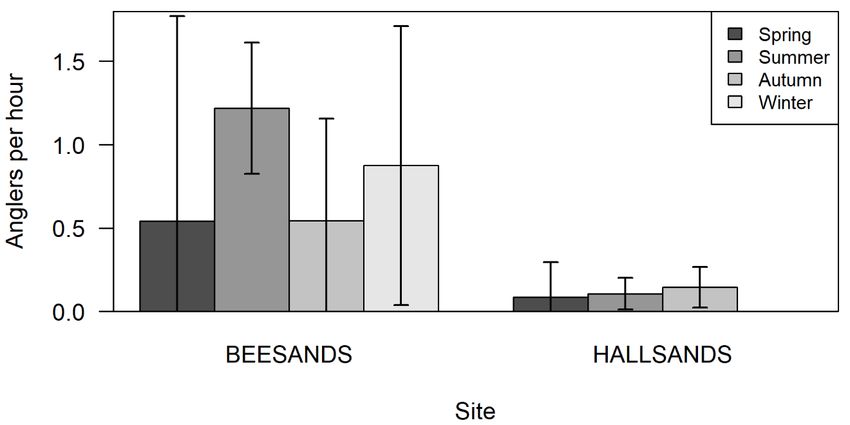
Beesands and 34 at Hallsands), including a total of 47 interviews (39 at Beesands and 8 at
Hallsands). The average survey time was equal at both sites (3.8 hours).

The number of shore anglers and rods were recorded as well as any other fishing activity or
sightings of commercial, charter and private RSA boats observed from the shore. Interviews
with anglers were conducted where possible to obtain data on fishing effort, species
targeted, compliance and awareness of the Angling Zone and Code of Conduct. Mann
Whitney U tests were used to assess differences in angling effort between locations, and
Kruskal-Wallis tests were used to assess differences in angling effort between seasons
within locations. For these analyses, seasons are defined as follows: Spring is March to
May, Summer is June to August, Autumn is September to November and Winter is
December to February; therefore, the spring data include May 2015 and March – April 2016.
The proportion of recreational anglers targeting specific species were also calculated for
each site. All plotting and analyses contained in this report were completed in R statistical
software, version 3.5.1 or later (R Core Team, 2018).

3.   Results

3.1. Angling effort, location and seasonality

Angling effort was significantly higher at Beesands (0.78 anglers per survey hour) than at
Hallsands (0.10 anglers per survey hour) (Mann Whitney U; W = 735.50, p < 0.001). A total
of 84 anglers were observed at Beesands across the entire survey period, using 151 rods. At
Hallsands only 13 anglers were observed across the survey period, using a total of 20 rods.
Based on angler estimates of their own angling activity, the respondents suggested that they
fished in the Skerries Bank area for an average of 5.3 days out of the three months
preceding the interviews (range 1 – 28).

Though angling activity appears to vary seasonally at both sites (Fig. 4), there was
substantial within-season variability in number of anglers, and seasonal differences in mean
number of anglers per hour were not statistically significant at either Beesands (Kruskal-
Wallis Χ2 = 1.42, p = 0.701; Fig. 4) or Hallsands (Kruskal-Wallis Χ2 = 4.05, p = 0.256; Fig. 4).

Figure 4. Seasonal mean number of anglers per hour at each site, showing 95% confidence intervals
as error bars.
                                                7
3.2. Target species
During the interviews, anglers indicated that a wide variety of species are targeted across
Beesands and Hallsands with plaice and bass being important species for both sites (Fig. 5).
Mackerel is also a popular species targeted at Beesands. One of the main concerns among
the respondents was the view that there has been a decline in one or more species of fish in
the area. This view was expressed by 23 individuals, though 8 others thought there had
been no change, and 3 thought that one or more species had increased in abundance.
Figure 5. Proportion of anglers targeting each species at Beesands and Hallsands, as identified in 39
and 8 interviews at each site respectively.
3.3. Angler behaviour and knowledge
The majority of recreational sea anglers interviewed (32 out of 47) advised they have been
fishing these sites for several years, with over half (29) fishing the areas for both sport and
food. Most respondents were not members of an angling club (30 non-members, and 15
members).
Interviews included sections on compliance and on the level of knowledge of the work of
D&S IFCA. Out of 47 respondents, 49% were aware of D&S IFCA, while 51% were unaware.
The level of awareness of the Angling Zone and the Code of Conduct was also low: only
22% of respondents were aware of the Angling Zone and the Code of Conduct. Given the
low awareness, it was difficult to assess compliance with the Code, including with
recreational bag limits. The fishing activities of three individuals were found to be compliant
with the Code of Conduct even though the individuals concerned were unaware of the Code.
One of the main concerns regarding broader compliance issues, as highlighted by
respondents, was illegal netting and trawling being carried out in the area. It should be noted
that there were no instances of illegal fishing activity observed by D&S IFCA officers or the
respondents during the survey period.
84. Discussion and Conclusions
Recreational and commercial fisheries are complex social-ecological systems that are
constantly adapting due to fisher priorities and behaviours (Brownscombe et al., 2019,
Matsumura et al., 2019). These stakeholder groups play an equally important role in inland
coastal environments (Kearney et al., 2002). However, conflict between the commercial and
recreational sector over shared resources, spatial access and different management
measures is a persistent issue for the majority of developed countries (Brownscombe et al.,
2019, Kearney et al., 2002). These existing conflicts within and between user groups must
be acknowledged and addressed in order for fisheries management to be successful
(Arlinghaus et al., 2019).
In combination with the Baseline Report, this shore-based survey indicates some crossover
in the spatial use of the Beesands and Hallsands area within the Skerries Bank Angling
Zone between commercial fishers, private RSA boats and shore-based anglers. Beesands
appears to be an important area within the Angling Zone for shore anglers as the majority of
angling effort was concentrated there during the survey period. The baseline report highlight
that this area is also utilised by the commercial sector and private RSA sector (Curtin and
West, 2019); however, the temporal use of the area varies between the shore anglers,
commercial boats and private RSA boats. During the summer months, activity at Hallsands
appears to be dominated by commercial fishers operating fixed nets, rod and line, and pots
(Curtin and West, 2019). Private RSA boats, however, tend to focus their efforts at Hallsands
during the spring. Shore-based RSA activity appears to be relatively consistent across the
year at both Hallsands and Beesands.
Boucquey (2017) highlighted that a common perception among recreational fishers is that
commercial netters use large nets that take up too much space and remove a large
proportion of the fish, therefore damaging their fishing opportunities. In turn, many
commercial fishers are of the opinion that recreational fishers invade their space and
disrespect the traditional use of nets (Boucquey, 2017). Similar concerns were raised by
each sector during the initial consultations outlined in the introduction to the current report.
Although spatial use by the three sectors overlaps in Beesands and Hallsands, competition
over spatial access and target species is likely to be minimal and limited to a relatively small
number of species due to fisheries targeting different species and the temporal variation in
use of these sites between the user groups. Plaice are an important species for shore
anglers, charter and private boat anglers. Anecdotal reports from the RSA sector suggest
that there has been a decline of fish within the Angling Zone. This could be a result of
environmental or biological variation, or increased commercial effort within the broader
geographic area. This issue is explored in greater detail in D&S IFCA’s linked report on the
status of key stocks (plaice and rays) and local landings of these species (Curtin and
Stewart, 2020).
At the current time, the Code of Conduct appears to be the most appropriate method of
management. This discourages commercial fishers targeting plaice within the Angling Zone
and includes a voluntary bag limit of ten plaice and three rays per day for recreational
anglers. Plaice were not targeted by the commercial sector, suggesting that their activities
were compliant with the Code of Conduct. However, it is important to note that awareness of
the Code of Conduct is low amongst the commercial sector (S. Curtin, pers. obs). Despite
there being good representation and involvement from all sectors at the initial consultations
and workshops, there is a lack of understanding and awareness of the Angling Zone and
9Code of Conduct. This general lack of knowledge within the RSA sector may lead to non-
compliance undermining the effectiveness of the Code of Conduct.
Several studies suggest that involving stakeholders and adopting a co-management
approach to inshore fisheries management can improve compliance and lead to a
sustainable fishery when compared to entirely top-down imposition of management
measures (Costanza et al., 1998; Ostrom, 1990; Rodwell et al., 2014). In the context of this
report, considering angler interests on equal footing with those of commercial fishers can
promote a shift in the community towards forward-looking and cooperative attitudes to
fisheries management and conservation (Arlinghaus et al., 2019). Similarly, education, fisher
participation in the management process and positive perceptions of conservation can all
contribute to increased compliance (Arias and Sutton, 2013; Pita, 2013; Smallwood and
Beckley, 2012). Promoting cooperative behaviour and improving awareness on a wider level
within the RSA sector may prove to be challenging based on the low level of club
membership (33%) seen during this survey, though it may be possible to engage with non-
club members through angling stores and other organisations such as the Angling Trust.
Sea angling clubs and Angling Trusts can prove to be pivotal stakeholders in the education
process within the RSA sector, as these types of organisations campaign on environmental
and conservation issues and advocate best fishing practices within their angling community
(Arlinghaus et al., 2019; Guckian et al., 2018).
The Skerries Bank Baseline Report (Curtin and West, 2019), the Blonde Rays and Plaice
Landings and Stock Assessment Report for Skerries Bank (Curtin and Stewart, 2020) and
this Shore Report are the first steps in monitoring a resource shared by various stakeholder
groups. It was beyond the scope of this work to assess the social, economic and
environmental benefits and impacts of the different activities, though such an assessment
would help to balance the costs and benefits of the exploitation of these sea fisheries
resources across multiple user groups. In addition, further engagement work is required to
increase awareness of the Angling Zone and the Code of Conduct within the RSA sector and
compare each user group’s activity levels against the baseline recorded in this and the
Skerries Bank baseline report. The comparison will provide valuable information on changes
in use of the area and whether the current management measures are sufficient in
promoting RSA opportunities, helping to balance the needs of multiple users of these
resources. This engagement work will involve telephone interviews with various stakeholders
in the commercial and RSA sector and where possible virtual or actual meetings. Interviews
will aim to obtain data on fishing effort, species targeted, and awareness of the Angling Zone
and Code of Conduct. Subject to restrictions associated with Covid-19, this engagement
work will take place during 2021-2022 with a report being produced for the D&S IFCA’s
Members for consideration..
10References
Arias, A. and Sutton, S.G. (2013). Understanding Recreational Fisher Compliance with
No-take Zones in the Great Barrier Reef Marine Park. Ecology and Society, 18(4): 18.
Arlinghaus, R., Abbott, J., Fenichel, E.P., Carpenter, S.R., Hunt, L.M., Alós, J., Klefoth, T.,
Cooke, S.J., Hilborn, R., Jensen, O.P., Wilberg, M.J., Post, J.R. and Manfredo, M.J. (2019).
Governing the recreational dimension of global fisheries. Proceedings of the National
Academy of Sciences of the United States of America, 116(12): 5209- 5213.
Blyth, R.E., Kaiser, M.J., Edward-Jones, G.,and Hart, P.J.B. (2002). Voluntary management
in an inshore fishery has conservation benefits. Environmental Conservation, 29: 493-508.
Boucquey, N. (2017). That's my livelihood, it's your fun’: The conflicting moral economies of
commercial and recreational fishing. Journal of Rural Studies, 54: 138-150.
Brownscombe, J.W., Hyder, K., Potts, W., Wilson, K.L., Pope, K.L., Danylchuk, A.J., Cooke,
S.J., Clarke, A., Arlinghaus, R. and Post, J.R. (2019). The future of recreational fisheries:
Advances in science, monitoring, management, and practice. Fisheries Research, 211: 247-
255.
Costanza, R., Andrade, F., Antunes, P., Van Den Belt, M., Boersma, D., Boesch, D.F.,
Catarino, F., Hanna, S., Limburg, K., Low, B., Molitor, M., Pereira, J.G., Rayner, S., Santos,
R., Wilson, J., Young, M. (1998). Principles for sustainable governance of the oceans.
Science, 281 (5374): 198-199.
Curtin, S. and Stewart, J.E. (2020). Blonde Rays and Plaice Landings and Stock
Assessment Report for Skerries Bank. D&S IFCA paper. September 2020. Available at:
https://www.devonandsevernifca.gov.uk/content/download/6362/44721/version/1/file/Blonde
+Rays+and+Plaice+Landings+and+Stock+Assessment+Report+for+Skerries+Bank+v1.0.pdf
Curtin, S. and West, E. (2019). Temporal and spatial use of the Skerries Bank Angling Zone
by different fisheries user groups: A baseline report. D&S IFCA paper. August 2019.
Available at:
https://www.devonandsevernifca.gov.uk/content/download/4165/31450/version/1/file/Skerrie
s+Bank+Angling+Zone+Report+Final+October+2019.pdf
Guckian, M.l., Danylchuk, A.J., Cooke, S.J. and Markowitz, E.M. (2018). Peer pressure on
the riverbank: Assessing catch-and-release anglers' willingness to sanction others' (bad)
behavior. Journal of Environmental Management, 219: 252-259.
Kearney, R.E. (2002). Co-management: the resolution of conflict between commercial and
recreational fishers in Victoria, Australia. Ocean & Coastal Management, 45: 201–214
Matsumura, S., Beardmore, B., Haider, W., Dieckmann, U. and Arlinghaus, R. (2019).
Ecological, angler, and spatial heterogeneity drive social and ecological outcomes in an
integrated landscape model of freshwater recreational fisheries. Reviews in Fisheries
Science & Aquaculture, 27:2, 170-197.
Ostrom, E. (1990). Governing the Commons: the Evolution of Institutions for Collective
Action. Cambridge University Press, Cambridge, United Kingdom.
Pita, C., Theodossiou, I. and Pierce, G.J. (2013). The perceptions of Scottish inshore fishers
about marine protected areas. Marine Policy, 37, 254–263.
11Rodwell, L.D., Lowther, J., Hunter, C. and Mangi, S. (2014). Fisheries co-management in a
new era of marine policy in the UK: A preliminary assessment of stakeholder perceptions,
Marine Policy, 45: 279-286.
Smallwood, C.B. and Beckley, L.E. (2012). Spatial distribution and zoning compliance of
recreational fishing in Ningaloo Marine Park, north-western Australia. Fisheries Research,
125–126: 40-50.
12You can also read