The Dutch Mapping of Indonesia - International Federation of ...
←
→
Page content transcription
If your browser does not render page correctly, please read the page content below
The Dutch Mapping of Indonesia
                             Dr. ir. Huib EKKELENKAMP, Netherlands

   Key words: Cadastre, Cartography, Engineering survey, Land surveying, Hydrography,
   Photogrammetry, History

   SUMMARY

   For centuries, maps have sparked people’s imagination of geographical reality. Large changes
   around 1800, both national and colonial, resulted worldwide in a significant increased demand
   for reliable maps. The Mapmaking of the Indonesian archipelago has been investigated in the
   period 1800-1990. Up to the transfer of sovereignty to the Republic of Indonesia in 1949, colonial
   relations influenced mapmaking. However, the impact of Indonesia’s colonial past on
   mapmaking and the applied geodetic methods is virtually unknown.
   A main question is the role and impact of the Netherlands presence in Indonesia in the technical
   and organizational development of geodesy and geodetic education in the Netherlands from
   1850 to 1950. Military and civil experts, sent to the Netherlands Indies, were often engineers.
   They published their technical results in annual reports, special documents and articles. Here
   we show that the Dutch presence in Indonesia had large impact on geodesy and the geodetic
   education in the Netherlands. In the framework of the history of science, the developments in
   geodesy have been investigated as base for the topographic and hydrographic surveying and
   mapping. Three areas are chosen where maps were indispensable and many maps emerged:
   towns and public works, railways and tramways and telecom connections. Population growth
   and rapid development of infrastructure from 1870 further stimulated the demand for maps. The
   geodetic challenges, which were the base for maps, are covered by navigation, positioning,
   hydrography, triangulation and photogrammetry. In some of these areas the Netherlands Indies
   played a leading role, benefitting the Netherlands with the obtained experience. Disturbing
   factors on measurements in the tropical environment, differed considerable from those in the
   Netherlands. The climate and the volcanos, atmospheric refraction, plumb line deflections,
   gravity anomalies and map projections required a different approach. The results of the
   Topographic Service, Land Registry and Hydrographic Service in the shape of maps and guides
   are covered.
   Hydrographic activities, including oceanographic expeditions in this archipelago, illustrate the
   importance of safe shipping routes and deep-sea research. Besides the topographical maps, also
   nautical maps, aviation maps and atlases are covered. A comparison is made with the initial geodetic
   activities in France, the Netherlands, Germany, Great Britain and India. India was comparable to
   the Netherlands Indies. The Topographic Service in Batavia (now Jakarta) followed closely the
   developments in these countries. A comparison has been made between the Netherlands and the
   Netherlands Indies using specific fields of interest such as astronomical observation, triangulation,
   height measurement, photogrammetry and hydrography. People with their limited means have
   achieved impressive results. The large volume of literature is their witness.

The Dutch Mapping of Indonesia (11064)
Huib Ekkelenkamp (Netherlands)
FIG e-Working Week 2021
Smart Surveyors for Land and Water Management - Challenges in a New Reality
Virtually in the Netherlands, 21–25 June 2021
1. INTRODUCTION

   Explorations, hydrographic and topographical surveys as a basis for the production of maps
   have required a great deal of pioneering work. The many islands with mountains and volcanoes,
   the seas in the archipelago, the culture and the tropical environment, which deviated entirely
   from the Dutch situation, where most experts initially came from, asked for a completely
   different approach. The extensive area, the limited available financial resources, expertise and
   possibilities for transport made the work a real challenge. Even though the send experts were
   trained as well as possible in the Netherlands, practical experience with instruments,
   measurements and processing of results gained in the tropics, was needed to map the
   archipelago. The knowledge and experience before that was still limited in Europe at the
   beginning of the 19th century. The shape of the Earth was still the subject of research. The
   influence of the measurement results by the atmosphere, gravity, measurement methods and the
   personal factor in measuring with the distinction between systematic errors and stochastic errors
   had not yet been fully recognized. Units of measure differed by country; standards were hardly
   there. Although the quality of lenses in telescopes, measuring instruments and the paper used
   for maps limited accuracy, impressive results were achieved. One advantage was that
   theoretical knowledge, especially that of mathematics, was already well advanced. Famous
   institutions were also set up, promoting knowledge exchange.
   Awarded prizes for the theoretical and practical solution of problems stimulated research. The
   urge to discover how the world was put together, the challenge of exploring new areas, the
   expansion of power and the possibility of enrichment by trade and industry have certainly
   contributed to the demand for maps. The creation of maps cannot therefore be separated from
   the political and economic circumstances. Safe shipping routes, terrain knowledge for soldiers
   in the event of unrest and wars, property ownership registration, tax collection in the form of
   land interest, exploitation of mineral resources, construction of roads, railways and
   telecommunications connections, each required specific maps. The available map material often
   proved to be insufficiently detailed or accurate, while with the expansion of government power
   over an ever-larger area there was also a need for new maps
   "Indonesia on the map" focuses on the way Indonesia has been mapped. It includes both
   hydrographic and topographical reconnaissance, survey and mapping. The maps of the
   Indonesian archipelago showed the administrative and economic centres and showed the
   geography and topographical information of settlements, connecting roads and defences of the
   various islands. Available map material was used for trade, governance and development of
   areas. The thematic maps displayed the current situation. These could be military situations, but
   also existing plantations, populations, religions, languages or prosperity. Maps were a source
   of information or showed the lack of information. In the annual Colonial Reports for the Dutch
   government, we regularly find these theme maps. It was often found that available maps were
   inaccurate or incomplete. For example, the reason could be a war, disaster or lack of
   information, necessary for taxation. This defect had to be remedied with great effort in the
   shortest possible time. This required well-trained personnel with knowledge of surveying,
   topographical and hydrographic inclusion and mapping.

The Dutch Mapping of Indonesia (11064)
Huib Ekkelenkamp (Netherlands)
FIG e-Working Week 2021
Smart Surveyors for Land and Water Management - Challenges in a New Reality
Virtually in the Netherlands, 21–25 June 2021
The situation in the tropical Indies was quite different from the Netherlands, so specific
knowledge of suitable instruments, methods and conditions was needed to obtain maps of
sufficient quality and usability. Despite the great distance and long travel time, there was a
regular exchange of knowledge and experience between Indonesia, the Netherlands and a
number of countries in Europe. This exchange took place from Europe to Indonesia as well as
from Indonesia to countries in Europe. Due to the extensive area with completely different
conditions, the Netherlands has been able to benefit from the specific knowledge and experience
gained in the Indian archipelago. The Dutch presence in Indonesia has contributed to the
development of geodesy and geodesy education in the Netherlands. The study identified three
areas of focus, for which maps were essential: cities and public works, railways and tramways,
and telecom connections. These three areas cover a wide range of technical disciplines and
partly overlap. After all, the construction of a railway line and a telecom connection was often
combined. A road construction, port development or extension often took place with a city
expansion. The choice of route between two places was determined by geographical limitations,
available expertise and resources, including human resources and costs. Mapping possible
routes was a prerequisite for making choices substantiated. The production of a reliable map
required a lot of specialist knowledge, which required thorough training. Maps were primarily
of strategic importance to the military in their actions. Initially, topographical explorations and
mapping were the domain of soldiers, but this changed with the arrival of training for civilian
engineers and Netherland-Indies officials from the middle of the 19th century.
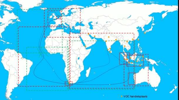
Index of VOC-sea charts with different map projections, scales and routes between The Netherlands and Batavia
during the presence and trade of the VOC (“Verenigde Oostindische Compagnie” or United East Indies Company)
The Dutch Mapping of Indonesia (11064)
Huib Ekkelenkamp (Netherlands)
FIG e-Working Week 2021
Smart Surveyors for Land and Water Management - Challenges in a New Reality
Virtually in the Netherlands, 21–25 June 2021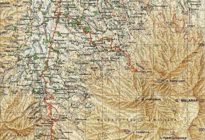
2. HISTORICAL OVERVIEW, DEVELOPMENTS IN THE ARCHIPELAGO

   In the VOC period (1602-1800), governance was a means of promoting trade. The VOC was not
   after land ownership, unless this could promote trade and profits. It was initially the spices of the
   Moluccas and pepper of Java and Sumatra that the VOC tried to obtain, later tobacco, indigo (dye),
   copper, tea, coffee, sugar, saltpetre (base for gunpowder), silk, cotton, textiles and porcelain were
   added. With the foundation on Java of Batavia in 1619, this centre was expanded by successive
   Governors-General. The board of the VOC was limited to the places with trading settlements. The
   map makers from the VOC period made an important contribution to the growth of the VOC. The
   maps were first of all intended for a safe journey by sailing ship around the Cape to and in the
   archipelago. In addition, maps of all trading posts and sometimes the surrounding area were created,
   with which later map makers and topographical service could benefit. Before, during and after the
   VOC period on the coast of the islands, numerous forts were built that were also important
   landmarks for orientation and navigation. It was initially the Portuguese and Spaniards who tried to
   map the world, soon the Dutch, French and English took the initiative and numerous expeditions
   were equipped to explore unknown areas. After the bankruptcy and acquisition of the VOC at the
   end of the 18th century by "the Dutch State", the board in Indonesia was changed under the
   influence of the Batavian-French Republic in the Netherlands. During this French period, the
   English conquered Java in 1811, and established an intermediate board with Raffles as a governor.
   Raffles introduced new laws and a new form of taxation, the land interest rate, which required new
   maps. He also stimulated institutions for the promotion of nature development, such as the botanical
   botanic garden in Buitenzorg and the study of the natural and cultural sciences. The return of Dutch
   authority in 1816 resulted in a new form of governance. Now it was the State that had an interest in
   protecting the population on the one hand, but on the other hand wanted to keep the state's
   expenditure as low as possible. When this did not work out so well, the Governor-General was
   instructed to set up the administration in such a way that the colony could provide for its own
   maintenance and, if possible, make a contribution to the Dutch treasury. The introduction of the
   “Cultuurstelsel” (compulsory growth and delivery of agricultural products against a fixed price) in
   1830 has more than lived up to this. The 19th century was marked by the Java War (1825-1830),
   the introduction and abolition of the “Cultuurstelsel” (1830-1870), the many wars such as the Padri
   and Aceh wars on Sumatra, at Boni on Sulawesi and those at Singkawang and Banjarmasin on
   Borneo. Partly because of these wars, good attention was paid to better maps of Java and Sumatra
   only in the middle of the 19th century. Systematic reconnaissance, survey, measurement and
   mapping took place from 1850. At the beginning of the 20th century, Java was well mapped.
   Sumatra, Borneo and Sulawesi and gradually the other islands of the archipelago also received good
   maps. In the period 1880-1920, the economy grew rapidly. Railways were built on Java and Sumatra,
   coal mines and oil wells were operated and plantations were developed for sugarcane, rubber, tea,
   coffee and tobacco that generated substantial profits. It was also the period when the islands were
   well mapped. Detailed maps were needed for the expansion of cities and the construction of
   infrastructure, including irrigation works, bridges and ports in addition to roads, railways and
   telecommunications facilities. When the Topographic Service was established in 1874, an
   important basis had already been laid for the further exploration and mapping of the archipelago.

The Dutch Mapping of Indonesia (11064)
Huib Ekkelenkamp (Netherlands)
FIG e-Working Week 2021
Smart Surveyors for Land and Water Management - Challenges in a New Reality
Virtually in the Netherlands, 21–25 June 2021
The Land Registry had to register its own land and home ownership, but also carried out land interest
   withdrawals as tax. As such, the Dutch East Indies was not inferior to the Netherlands. The
   development of roads, needed by increasing car and bus transport, also required major
   investments. For shipping, ports were enlarged and newly constructed and waterways deepened.
   The Second World War (WWII), with the Japanese occupation from March 1942 to August 1945,
   created a completely new situation. The Dutch government was wiped out and the Japanese took
   over with the help of Indonesians. For the Indonesians, there was hope for independence, but it
   soon fell to the bottom. Many Indonesians died as Romushas (forced labourers). Many interned
   Dutch people were killed by forced labour and poor conditions in camps scattered throughout the
   archipelago. The Allies made numerous photographic aerial shots, which they combined with the
   Dutch maps in detailed attack plans for strategic purposes. After WW II, maps were made for the
   negotiations and the Dutch-Indonesian liberation war (called police actions by the Netherlands).
   The impending war with Indonesia by the New Guinea question also required maps of a hitherto
   little-known area. Parts of New Guinea were not properly put on the map until after WWII. After
   the transfer to the Republic of Indonesia at the end of 1949, Dutch maps were used for a long
   time. With the application of satellite recordings and digitization, detailed maps of almost the
   entire archipelago have become available, which now form a basis for the development of the
   country and tourism.
   With the transfer of New Guinea to the Republic in 1963, the maps in Indonesia had to be adjusted
   again. Dutch topographic names were replaced by Indonesian names. After a period of intense
   unrest and economic stagnation, the economy and tourism began to develop slowly in the 1970s.
   Around the turn of the century, a huge construction activity arose, supported by strong economic
   growth with good prospects. Jakarta's skyline was even more dominated by tall office buildings
   and hotels. There was a great need for detailed maps all the time. Jakarta with the surrounding
   area gained 30 million inhabitants. Yudhoyono (2004-2014) and Widodo (from 2014) were
   elected president by democratic elections; a new phase had arrived.
   Although Indonesia has many raw materials in the form of petroleum, natural gas, minerals and
   wood, almost half of the population lives on the yield of agricultural products such as tea, coffee,
   tobacco, spices, rice, cocoa, rubber, copra, palm oil, wood and rattan. In addition, the industry is
   developing faster and faster. With a large internal market and a large number of natural products,
   Indonesia occupies an important place in the economic development of southeast Asia. Tourism
   is also an important source of income, so good tourist maps are needed.
   The Indonesian archipelago covers a large area of approx. 2000 km north to south and approx.
   5300 km from west to east with three different time zones: UTC+7, UTC+8 and UTC+9. The
   archipelago is located in Asia around the equator between 6° north latitude and 12° south latitude
   and between 94° and 142° east longitude of Greenwich (see also the map hereafter). The capital
   Jakarta is located at 107° east longitude. In the Dutch East Indies time, the zero meridian was laid
   over Batavia and the distances were determined in longitudes compared to this meridian. The
   equator runs over central Sumatra and Pontianak on Kalimantan, the Indonesian southern part of
   Borneo (see also the next map). Indonesia is therefore both below and above the equator and has
   a tropical climate with dry and wet seasons (monsoons). The rainy season around and south of the
   equator runs from November to February; north of the equator to India it falls a few months later.

The Dutch Mapping of Indonesia (11064)
Huib Ekkelenkamp (Netherlands)
FIG e-Working Week 2021
Smart Surveyors for Land and Water Management - Challenges in a New Reality
Virtually in the Netherlands, 21–25 June 2021
The average annual temperature at sea level is around 26-28 degrees Celsius nationwide and the
relative humidity is usually higher than 85%. The temperature decreases with an increase in height;
on mountain peaks above 3000 m there are temperatures below 10 degrees Celsius. The distance
between the Netherlands (Amsterdam) and Indonesia (Jakarta) is approximately 11,500 km, via the
Cape the distance is approx. 21,000 km and via the Suez Canal (after 1869) about 13,000 km.
10° Thailand
Nakhon si
Indonesië 1.920.000 km2
Thammarat
Phuket Mindanao Java 132.000 km2
Zamboanga Davao
Kota Kinabalu Sandakan Filipijnen Nederland 37.354 km2
Banda Aceh George Town Kota Bharu
100 200 300
Bandar Seri Begawan
Maleisië Brunei Sabah 1000 km
Medan Kuala Maleisië Bintulu Morotai
Simeulue Lumpur Sibu Borneo
Dumai Sarawak
Kuching Manado
Nias Sumatra Singapore Ternate Halmahera
Pekanbaru Singkawang Kalimantan Gorontalo
Pontianak Samarinda
0° Rengat Riau Sintang
Palu
Luwuk
Padang Balikpapan Sorong
Bangka Sula Manokwari
Jambi
Siberut Pangkalpinang Palangkaraya
Palembang Tanjungpandan Sulawesi Molukken Jayapura
Ceram
Bengkulu Lubuklinggau Belitung
Banjarmasin Parepare
Kendari
Buru Ambon
West Papua
en Papua
Bandar Lampung Java zee Makassar
Jakarta Baubau Banda zee
Kai
Semarang Madura Aru
u
Bandung Java Wetar
Tanimbar
Yogyakarta Surabaya Bali Lombok
Mataram Bima Floris
Ruteng Dili Merauke
Indische Oceaan Denpassar Sumbawa Arafura zee
Waingapu Timor
10° Christmas Island Sumba Kupang
Timor zee
Darwin
100° 110° 120° 130° Australië 140°
Indonesian archipelago and adjacent countries
West Java, Le Clerck, 39 x 108 cm, 1 map in 2 sheets, scale 1:1.000.000, A.J. Bogaerts Breda 1850. Le Clerck
explored large parts of Java and Sumatra. He arrived in Batavia in 1844 with the task of examining the defensive
system in the Indies and checking whether it could not be simplified. This was in 1850 one of the best maps.
The Dutch Mapping of Indonesia (11064)
Huib Ekkelenkamp (Netherlands)
FIG e-Working Week 2021
Smart Surveyors for Land and Water Management - Challenges in a New Reality
Virtually in the Netherlands, 21–25 June 2021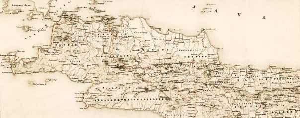
3   MAPS FOR URBAN AND INFRASTRUCTURE DEVELOPMENT

   Until 1800, Indonesia hardly knew cities of any size. The largest cities of Batavia and Surabaya had fewer
   than 50,000 inhabitants, while the total population in the archipelago was barely 5 million inhabitants. That
   had risen to more than 250 million in 2016, about half of them on Java and Madura. This expansion of
   cities with the construction of new homes and facilities, such as schools, offices, hospitals and factories,
   required good urban planning, for which maps were indispensable. The registration of the property by the
   Land Registry with data on property, place, size and type or character also became increasingly important.
   This was reinforced by the possibility of taxing or distributing taxes more evenly. Around 1800,
   infrastructure in the form of roads, bridges and ports was very limited. The VOC had set up a number of
   roads for its administrative and commercial activities to transport goods between ships and warehouses. It
   was only with the arrival of Governor Daendels in 1808 that the “Grote Postweg” along the North coast of
   Java became the first paved connection between the major cities on Java after 1809. As a result, the travel
   time from Batavia to Surabaya could be significantly reduced over the distance of 900 km, or 300 hours
   by foot. As a result, letters took 6-7 days instead of 3 weeks, while passengers could now reduce their
   travel time from one month to 10 days by horse and carriage. The tropical rainstorms allowed the rivers to
   swell in a short time to large bodies of water, leading to major flooding. In the dry season there was a lack
   of sufficient water for the irrigation of agricultural land. Waterworks for regulation of too much and too
   little water were therefore increasingly given priority. This was reinforced by the increasing influence of
   the colonial government, which from 1830, with the introduction of the “Cultuurstelsel”, had every interest
   in increasing the yield of agricultural products. From 1860 onwards, serious research was carried out into
   the possibility of rail links. In Java, the need for rapidly efficient transport of agricultural products to the
   ports arose, while transport of people between the major cities also became increasingly important. The
   railway development first saw the government as a private initiative, for which it provided concessions.
   Soon, the strategic and economic importance led to state construction and exploitation. Railways on
   Sumatra were initially used for transporting coal and agricultural products to coastal ports. The first
   construction of telegraphic connections also took place along the railways. This allowed the arrival of a
   train to be announced and it was possible to send text messages in the form of telegrams. Railways and
   telegraphy, later telephony, were closely linked. In addition to the railways, telegraph and telephone lines
   are indicated on most of the detailed maps. Initially, the PTT used air lines for telegraph and telephone
   connections in the form of iron or copper wires, suspended from poles along roads and railways. That was
   a costly investment, which required a lot of maintenance. The air-lines, without amplifying the signal,
   allowed bridging of distances of 50 to 100 km. In addition, the capacity of the connection was initially
   limited to one signal or call per wire pair, so that soon, especially in cities, large numbers of wires hung
   from sturdy masts were needed. With the advent of radio connections for long-distance traffic, new
   possibilities arose. The wireless connection between the Netherlands and Indonesia in particular, proved
   to meet a great need. Most of the time, private initiative created infrastructure, such as railways, telecom
   connections and ports that, once successful, were taken over by the state. The state's traffic companies
   therefore played a major role in the further development.

   3.1 Cities and public facilities

   The first voyage of hydrographer Pieter Melvill van Carnbee was to the East Indies in 1835. Back in
   Holland he immediately started making sea charts. In 1839 he was promoted to lieutenant-commander and
   left again for the East Indies, where he was placed at the hydrographic office of the Department of The
   Navy and charged with the production of maps. In 1844 his first map of Java was completed.

The Dutch Mapping of Indonesia (11064)
Huib Ekkelenkamp (Netherlands)
FIG e-Working Week 2021
Smart Surveyors for Land and Water Management - Challenges in a New Reality
Virtually in the Netherlands, 21–25 June 2021
He worked on the composition of a general atlas of the Dutch East Indies. The first volume was published in
   1853. In 1856 he became director of the Navy on the island of Onrust (shown on the map below) where he
   succumbed to fevers in 1856. Hereafter impressions of urban development of Batavia (now Jakarta) are given.

        West Java, Batavia and surroundings, Pieter Melvill van Carnbee, (1816-1856) scale: 1:290.000, 1853.

   Jakarta kota (old town), town hall of 1710, now museum,          Jakarta kota, Post- and Telegraph-office 1911

   Jakarta view south, volcano Gunung Salak in the background         Jakarta, Welcome monument in Menteng

The Dutch Mapping of Indonesia (11064)
Huib Ekkelenkamp (Netherlands)
FIG e-Working Week 2021
Smart Surveyors for Land and Water Management - Challenges in a New Reality
Virtually in the Netherlands, 21–25 June 2021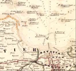
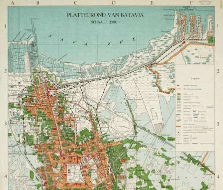
Batavia, Tanjung Priok and Weltevreden (Gambir), railways and harbour, scale 1:20.000 in 1945.

   3.2 Railways and tramways

   The railways and tramways shown on the map of Batavia above in 1945 and on Java below in 1930 indicate
   their importance for public travel and transport of goods and agricultural products between major cities.
   Most of the railway lines had a width of 1067 mm (3' 6"), smaller than in Europe to reduce costs.

                            Main railways and tramways on Java and Madura in 1930.

The Dutch Mapping of Indonesia (11064)
Huib Ekkelenkamp (Netherlands)
FIG e-Working Week 2021
Smart Surveyors for Land and Water Management - Challenges in a New Reality
Virtually in the Netherlands, 21–25 June 2021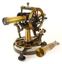
In mountainous areas, in particular West Java, careful route surveys were required to minimise the
   number of viaducts, tunnels and excavations. Length profiles indicated the height as a function of the
   track length and thus the rise and fall of the track. Those slopes were not allowed to exceed certain
   values in order to be able to deliver sufficient traction with the wheels of the locomotives on the rails
   and by preventing the tilt of the locomotives on the slopes, the drying of the upper flame pipes in the
   firebox of the locomotives.

                                         Railways in the Preanger, West Java

   Railways near Padalarang (West of Bandung): junction of the Batavia‒Purwakarta‒Plered‒Padalarang‒Bandung
   railway and the Batavia‒Bogor‒Sukabumi‒Cianjur‒Padalarang‒Bandung railway, scale 1:50.000 map of 1923.

The Dutch Mapping of Indonesia (11064)
Huib Ekkelenkamp (Netherlands)
FIG e-Working Week 2021
Smart Surveyors for Land and Water Management - Challenges in a New Reality
Virtually in the Netherlands, 21–25 June 2021
3.3 Telecom networks
The drawing and topographic map of Radio Malabar (or Radio Bandung) shown below, give a good
impression of the importance of maps for planning. The powerful LF sender and antenna of 2,1 km, hung
on cables between mountain tops was in 1923 the first and largest long-distance transmitter in the world.
Radio Malabar transmitter station with longwave antenna for communication with The Netherlands in 1923
Transmitter station with antenna at Malabar, near Bandung, scale 1:50.000, grid 1x1 km, map 1908, revised 1934.
The Dutch Mapping of Indonesia (11064)
Huib Ekkelenkamp (Netherlands)
FIG e-Working Week 2021
Smart Surveyors for Land and Water Management - Challenges in a New Reality
Virtually in the Netherlands, 21–25 June 20214 GEODETIC MEASUREMENTS AND INSTRUMENTS
The geodetic measurements in the East Indies differed from Europe due to different landscapes, climate
conditions and available resources. Deployed military experts and engineers had no experience with
surveying in tropical mountain country, there was also little literature, so knowledge had to be gained
in practice. Moreover, the number of experts was small and local forces had to be called upon, with
language problems also causing limitations. In Indonesia, dozens of languages are spoken, while some
languages such as Javanese and Sundanese on Java were difficult for the experts to learn. The Leiden
astronomer Jean Abraham Crétien Oudemans (1827-1906) was sent to the East Indies in 1857 to capture
places in the archipelago with astronomical observations. Fortunately, he recognized in time that
triangulation was a better method for an accurate base for mapping. In 1860-1880, triangulation was the
first to measure the primary network on Java; 3 baselines were used in West-, Central- and East-Java.
The elaboration of these primary measurement results by Oudemans, first in the East Indies and after
1875 in the Netherlands, lasted until 1900.
Then in 1883 triangulation measurements on Sumatra were started with a base measurement at Padang.
Batavia was chosen as a zero meridian, taking numerous measurements before the distance between
Batavia and Greenwich was sufficiently precise. For the longitude, sea cables and radio connections,
including Radio Malabar, were used. Over the western Barisan Mountains, triangulation was used with
a new base at Lake Toba, a connection to Java and a base in Aceh in the north. In the sparsely populated
eastern flat part, which consisted largely of swamp with many rivers, the fixed points were determined
with astronomical measurements. The measurements were influenced by refraction due to the deflecting
refraction through the atmosphere and plumb line deviations due to the attraction of the plumb under
the instruments by a large mass such as mountains. For this purpose, corrections were always made, so
that the measurements were repeated frequently. Some examples of measuring instruments used are
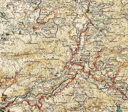
shown below. The maintenance was done locally. De triangulation around the base, north of Lake Toba,
is shown on the next page. Here the status of triangulation of end 1912 is given with links in red lines.
Universal instrument Repsold Universal theodolite Boussole tranche-montagne
for astronomical positioning Pistor & Martins for triangulation De Koningh for triangulation
The Dutch Mapping of Indonesia (11064)
Huib Ekkelenkamp (Netherlands)
FIG e-Working Week 2021
Smart Surveyors for Land and Water Management - Challenges in a New Reality
Virtually in the Netherlands, 21–25 June 2021Sumatra’s East Coast, status of triangulation end of 1912. The primary triangulation and survey of Sulawesi began in South Sulawesi in 1910 and was not completed until 1939. The TD (Topographical Service) used a baseline at Jeneponto (measured in 1911 south of Makassar), at Tondano (south of Menado) and at Korodolo (in the middle of Sulawesi). On Kalimantan, the Indonesian part of Borneo, the TD also opted for astronomical positioning. Due to the many rivers in the west and south, vessels could be used for transport of the chronometers, like on Sumatra. From 1922, telegraphic signals, transmitted by Radio Malabar, were also used to determine the longitude more accurately. The Topographical Service was given separate brigades for triangulation and survey. The triangulation brigade, led for years by ir. J.H.G. Schepers was the core. Schepers later became extraordinary professor at the Technical College in Bandung. The TD had a maximum staff of 700 experts, including a drawing and reproduction department and maintenance staff for all instruments. The Dutch Mapping of Indonesia (11064) Huib Ekkelenkamp (Netherlands) FIG e-Working Week 2021 Smart Surveyors for Land and Water Management - Challenges in a New Reality Virtually in the Netherlands, 21–25 June 2021
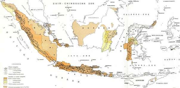
Netherlands-Indies archipelago (western and central part), status primary triangulation end of 1939.

   After World War I, photogrammetry with aerial photographs from airplanes emerged. Many experiments
   have been carried out in Indonesia for this purpose, especially to map difficult-to-access areas. This was
   found to produce useful results and, moreover, to speed up surveys and mapping of large areas. After
   experiments on Java and Banka, some inaccessible areas of New Guinea in the east were mapped by
   photogrammetry in cooperation with the Netherlands. The result was that in 1939 large parts of western
   and central Netherlands-Indies obtained a triangulation network supplemented by photogrammetry.
   Papua New Guinea in the east was only partly mapped, based on photogrammetry after WWII.

   With the increase in shipping traffic, the greater required draught for ships and the greater attention to
   safety, the need arose for the systematic survey of the seas in the archipelago. In the middle of the 19th
   century, special surveying vessels were used for this purpose, initially sailing ships but soon steamships.
   A separate service was established, which was part of the ”Gouvernements Marine”

   Hydrographic surveyed areas in green, end of 1926               Survey vessel Willebrord Snellius 1929-1937

The Dutch Mapping of Indonesia (11064)
Huib Ekkelenkamp (Netherlands)
FIG e-Working Week 2021
Smart Surveyors for Land and Water Management - Challenges in a New Reality
Virtually in the Netherlands, 21–25 June 2021
5 GEODETIC ACTIVITIES AND RESULTS

   Below some examples of results of geodetic activities are given. From the initial surveys to the final
   maps all activities were performed by the Topographical Service with a staff of only 400 to 700
   employees, excluding local hired people for carrying and provisioning of food.
   The result was high-quality maps, resistant to use in the tropics which were not inferior than the maps
   from Europe so that they won many prizes at international exhibitions and were in great demand by the
   companies and population in Indonesia and in other countries as well.

                        Java, part of map Surabaya Residency, scale 1:100.000, 1883-1884.

     Sea chart South-West Celebes (Sulawesi), detail Street Makassar with lighthouses, scale 1:1.000.000, 1883.

The Dutch Mapping of Indonesia (11064)
Huib Ekkelenkamp (Netherlands)
FIG e-Working Week 2021
Smart Surveyors for Land and Water Management - Challenges in a New Reality
Virtually in the Netherlands, 21–25 June 2021
6 CONCLUSIONS
'Indonesia on the map' refers to the broad field of exploration and geo-measurement by triangulation,
altitude measurement, depth measurement and topographical or hydrographic surveys for mapping
known and unknown areas. In the period under investigation from 1800 to 1990, this was done with
precise measuring instruments and experts with knowledge of the situation, who performed great
physical and intellectual performance. They were soldiers, civilian engineers and civil servants,
supported by porters and scouts often consisting of poorly paid local residents or forced labourers, who
had to do their work under difficult conditions. Their commitment and perseverance deserve great
appreciation. They ensured that the basis for the current mapping was laid and that the Netherlands and
Indonesia could benefit from this through better maps and greater knowledge of geodesy.
REFERENCES
Annual report of the “Topographischen Dienst” in the Dutch East Indies for 1905-1939 (issued annually in Dutch by the Topographical
Service, Batavia 1929-1939).
Colonial Report; annually 1855-1930 and Report of Governance and state of the Dutch East Indies; annually 1931-1938 with attention to:
− Territory, population and administration, Army, Navy and Justice (including Topography, Hydrography and Geodesy).
− Finance (court of auditors, compatibility, banks), Civil management.
− Domestic administration (including agricultural, statistical and topographical inclusions, Land Registry).
− Education, worship and industry (including arts and sciences, charity institutions, medical service).
− Civil Public Works (roads, bridges, ports, irrigation, railways, telegraphy and telephony).
− Industry (outdoor property, agriculture, forestry, animal husbandry, mining, plantations, factories, merchant shipping, shipbuilding).
− The state, financial and economic situation; under 'Traffic' means country roads and bridges, road traffic, rail traffic, port authority and
dredging company, demarcation, coastal lighting, pilotage, hydrographic surveys, shipping, air traffic, mail, telegraph, telephone and
tourism; 'Water Management' means a policy, flood defences and land buildings; under "Arts and sciences": archaeology service, theatre,
dance, music practice, national archive, folk libraries, nature conservation, volcanological research and scientific institutions.
− The cultural and social situation including under "Protection of land ownership": Cadastral and topographical surveys.
− The state establishment containing: government, people's council, administration, judiciary, police, army and navy.
BIOGRAPHICAL NOTES
Dr. Ir. Huib. Ekkelenkamp studied electrical engineering and telecommunications at Delft University of Technology. His promotion at Delft
University of Technology department of Geodesy in 2019 dealt with “Indonesia on the map”, The role of the Dutch presence in Indonesia in
the development of geodesy in the Netherlands. During his workable life he researched fibre optic communication at the PTT laboratory and
then worked internationally for PTT, later KPN, in the field of telecom network planning for a large number of years, many of which were in
Indonesia and Central and Eastern Europe. He held management positions in Telecom Consultancy and IT Business Development at KPN and
Atos. Measuring instruments and processing of measurement data, now and in the past, are of particular interest. This is especially true for
navigation aids, geodetic measuring instruments and precision clocks. Based on his interest in new technical developments and history of
technology, in particular telecommunications, geodesy and cartography, he performs functions at the Royal Institute of Engineers and at the
Stichting De Hollandsche Cirkel for the preservation of geodetic heritage in The Netherlands.
CONTACTS
Dr. ir. Huib Ekkelenkamp
De Hollandse Cirkel
Address: Post box 9046
Postal code and city: 7300 GH Apeldoorn
THE NETHERLANDS
Tel. +31 630082393
Email: huib.ekkelenkamp@gmail.com
The Dutch Mapping of Indonesia (11064)
Huib Ekkelenkamp (Netherlands)
FIG e-Working Week 2021
Smart Surveyors for Land and Water Management - Challenges in a New Reality
Virtually in the Netherlands, 21–25 June 2021You can also read