The FireLoc Project: Identification, Positioning and Monitoring Forest Fires with Crowdsourced Data
←
→
Page content transcription
If your browser does not render page correctly, please read the page content below
The FireLoc Project: Identification, Positioning and Monitoring Forest
                          Fires with Crowdsourced Data

     Cidália C. FONTE, Alberto CARDOSO, Jacinto ESTIMA, José-Paulo de ALMEIDA
                          and Joaquim PATRIARCA, Portugal

   Key words: Volunteered Geographical Information, Forest Fires, Mobile platforms,
   Information system, Intelligent systems.

   SUMMARY

   The severity and impacts of forest fires have increased in the last years in several parts of the
   world, where devastating fires occur now almost every year. As these types of events are likely
   to increase due to climate changes, it is important to develop tools to assist authorities in the
   early identification and geolocation of ignitions so that they can be tackled as fast as possible.
   Several types of systems are currently being used, and others are under development, to
   automatically detect fires, based on, for example, thermal cameras and observation points; even
   so, the more systems available to detect these events and identify their location at an early stage,
   the better. This fact motivated the FireLoc project, currently under implementation, which aims
   to develop a system that will enable citizens to provide georeferenced data allowing the
   detection and geolocation of spotted fires in real time. The FireLoc system includes a dedicated
   app that enables citizens to report a spotted fire using their own smartphones. The app
   automatically collects the observer’s geolocation, a photograph of what is being observed, the
   orientation, and the approximate distance between the observer and the observed event. The
   FireLoc system stores reported data and includes functionalities for their validation, for data
   integration and processing to identify the location of spotted fires, as well as visualization of
   extracted information for several types of users, such as authorities and citizens. This paper
   presents the various components of the FireLoc project, the main challenges that are faced to
   obtain reliable geolocation of the observed events, and the results obtained with the first sets of
   collected data.

The FireLoc Project: Identification, Positioning and Monitoring Forest Fires with Crowdsourced Data (11192)
Cidália C. Fonte, Alberto Cardoso, Jacinto Estima, José Paulo Almeida and Joaquim Patriarca (Portugal)
FIG e-Working Week 2021
Smart Surveyors for Land and Water Management - Challenges in a New Reality
Virtually in the Netherlands, 21–25 June 2021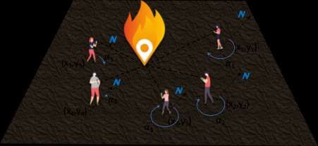
The FireLoc Project: Identification, Positioning and Monitoring Forest
                          Fires with Crowdsourced Data

     Cidália C. FONTE, Alberto CARDOSO, Jacinto ESTIMA, José-Paulo de ALMEIDA
                          and Joaquim PATRIARCA, Portugal

           1.   INTRODUCTION

   Wildfires in the world, such as those in Australia, California or the south of Europe, consumed
   millions of hectares of forests over the last years (Futurearth, 2021; Landscape News, 2020;
   Kolden, 2020). The loss of human lives is high, and the costs associated with firefighting,
   environmental losses, property and infrastructures damage, as well as recovery of burnt areas,
   are also very high. Due to climate changes, it is foreseen that these phenomena will become
   even more frequent and severe in the next few years (Cleetus & Mulik, 2014).

   When the conditions become favorable for fire spread due, for example, to the lack of moisture
   in the vegetation and atmosphere, high temperatures and strong winds, these devastating events
   become uncontrollable (e.g., Liu et al., 2015; Viegas, 2012; Rossa, 2015). Therefore, it is
   extremely important to identify ignitions and their exact location as soon as possible, so that
   the fire can be managed before reaching uncontrollable proportions.

   In 2017, extreme wildfires occurred in Portugal destroying 557,743 ha of forest and natural
   vegetation (ICNF, 2020), but also agricultural regions, factories and human settlements. The
   most devastating fire occurred in October 2017, where 50 people lost their lives due to the
   violence and fast spread of the fire. This raised awareness about the importance of increasing
   the number and diversity of detecting mechanisms that may provide useful information to
   authorities at the beginning and during the event.

   The identification of forest fires in Portugal is made from surveillance towers either by
   equipment installed for automatic monitoring (CICLOPE, 2021) or trained personnel, which
   enables the identification of events location in a fast and efficient way. However, observation
   towers do not cover the entire territory (Rego et al., 2004). The alternative and complementary
   way to identify fire ignitions relies on citizen reports using the emergency telephone number
   112. In this case, citizens need to describe the event and its location without an automatic
   georeferencing system. Therefore, it may be difficult to identify its exact location, which would
   be valuable to assess immediately the associated risk, activate the appropriate means of combat
   at an early stage, as well as the best way to reach it in a short time.

The FireLoc Project: Identification, Positioning and Monitoring Forest Fires with Crowdsourced Data (11192)
Cidália C. Fonte, Alberto Cardoso, Jacinto Estima, José Paulo Almeida and Joaquim Patriarca (Portugal)
FIG e-Working Week 2021
Smart Surveyors for Land and Water Management - Challenges in a New Reality
Virtually in the Netherlands, 21–25 June 2021
The above-mentioned aspects motivated the development of the project “FireLoc – Where’s the fire? - Identification, positioning and monitoring forest fires with crowdsourced data” (https://fireloc.org), so that georeferenced data is available from the very early stage of the fire identification. The FireLoc system aims to collect data about forest fire observations from citizens using a dedicated app and enables the automatic identification of the location of observed fires from a few observation points. The system is based on the contributions of citizens, that is, on georeferenced crowdsourced data, also called Volunteered Geographic Information (VGI). VGI has emerged as a new resource for collecting data that may be useful for many types of applications, including improving the management of emergencies (e.g., Horita et al., 2015; De Albuquerque et al., 2015). This type of projects has the capability of providing huge amounts of data that otherwise would be difficult, expensive or even impossible to collect, particularly in a real or near real-time manner. However, the nature of VGI raises many challenges, concerning, among other aspects, the quality and reliability of data, which is influenced by many aspects, such as the data collecting devices and protocols, the volunteer’s expertise, interests or intentions (e.g., Antoniou et al., 2016; Fonte et al., 2017; Senaratne et al., 2016). Additionally, large quantities of data require the use of mining techniques to filter them according to their quality and fitness for use (Rehrl et al., 2016). This last aspect is particularly important when data are to be assessed in real-time or near real-time, as in this case these processes need to be fully automated. Before the conception of the FireLoc project, experiments were made to extract citizens’ contributions about spotted fires from existing social networks, such as Facebook, Instagram or Flickr, using their available Application Programming Interfaces (APIs). However, the data with available direct georeferencing (i.e, associated coordinates) may be scarce, as they are just a small fraction of the available data. Moreover, the data collection protocol, in these projects, does not allow the collection of all necessary data to locate the event as well as the observer (Fonte et al., 2018; Fontes et al., 2017). This motivated the development of: (i) a dedicated app that enables the collection of all necessary data, and (ii) a system that integrates all the collected data with other available data and information, processes the data to assess the quality of the contributions, determines the location of the observed events and displays the data to different stakeholders, including the general public. The components of the FireLoc system are further explained in section 2. Then, in section 3, some preliminary results are presented and discussed. The main challenges that are faced to obtain reliable geolocation of the observed events are then presented in section 4. Finally, some conclusions and future work are presented in section 5. The FireLoc Project: Identification, Positioning and Monitoring Forest Fires with Crowdsourced Data (11192) Cidália C. Fonte, Alberto Cardoso, Jacinto Estima, José Paulo Almeida and Joaquim Patriarca (Portugal) FIG e-Working Week 2021 Smart Surveyors for Land and Water Management - Challenges in a New Reality Virtually in the Netherlands, 21–25 June 2021
2.   COMPONENTS OF THE FIRELOC SYSTEM

   The FireLoc system comprises the following three main components:
   1) A data collection component (i.e., the FireLoc app) developed specifically for mobile
   devices.
   2) A data integration and processing component, which includes a geospatial component and
   therefore will be developed using Geographic Information Systems (GIS) software, and will
   allow to evaluate the credibility of the reported information and also the identification of the
   geolocation of events and their geospatial extent.
   3) a component for providing information to the general public and institutional stakeholders
   (including the authorities involved in civil protection), with different user profiles, developed
   for both the mobile and desktop platforms enabling to monitor the progress of reported events.

            2.1 The FireLoc app

   The FireLoc system includes a mobile application (the FireLoc app) to allow citizens to submit
   data about observed forest fires. A protocol for data collection was developed to collect all data
   necessary to geolocate the observed events and assess their reliability. Data collected with the
   app is listed in Table 1, where it is also indicated if the collection is automatic or manual, and
   which data are mandatory or optional.

    Data                                                                         Collection mode

    Temporal data: Date and time (hour and minute) of the Mandatory / Automatic
    contribution

    The geolocation of the observer: The coordinates of the Mandatory / Automatic
    observation point obtained with the smartphone’s Global
    Navigation Satellite System (GNSS) receiver imbedded in the
    device

    Orientation: The orientation of the smartphone is collected when Mandatory / Automatic
    the contributor is oriented towards the fire. It corresponds to the
    bearing relative to the magnetic North pole, extracted from the
    compass imbedded in the device

The FireLoc Project: Identification, Positioning and Monitoring Forest Fires with Crowdsourced Data (11192)
Cidália C. Fonte, Alberto Cardoso, Jacinto Estima, José Paulo Almeida and Joaquim Patriarca (Portugal)
FIG e-Working Week 2021
Smart Surveyors for Land and Water Management - Challenges in a New Reality
Virtually in the Netherlands, 21–25 June 2021
Photograph: A photograph taken by the contributor of the Mandatory / Manual
observed event. This photograph will be used to validate if the
contributor is in fact observing a fire or smoke with an automated
approach (see section 2.2), and will enable the visualization of
the spotted event within the system
The orientation (bearing) of the smartphone when the volunteer Optional / Automatic
orients himself/herself towards his/her shadow.
The geolocation of the observer after the volunteer moves 10 Optional / Automatic
steps forwards of backwards in the direction of the fire
Distance: The approximate distance between the observer and Optional / Manual
the spotted fire
Short text messages Optional / Manual
Table 1. Data collected with the FireLoc app and collection mode.
The time of observation, the geolocation of the observer, and the orientation of the device when
facing the fire, are collected automatically by the app when the user follows the protocol for
data collection, consisting of the following sequence of steps:
1) Initiate the app.
2) Observe the measured location over a map, and check if it is correct. If not, the volunteer
may correct the location by moving the pin over a map.
3) Orient himself/herself to the fire and confirm if the displayed bearing can be recorded.
4) Take a photograph of the event.
5) Orient himself/herself to the shadow and confirm the registration of the bearing (this
step may be discarded by the volunteer).
6) Move forward or backwards 10 steps in the direction of the fire and confirm the new
location (this step may be discarded by the volunteer).
7) Indicate the approximate distance to the event (optional)
8) The option of adding a text message follows, which may be discarded.
9) End the contribution (and a message is received confirming the contribution).
In step 2 above, the opportunity to correct the location obtained with the GNSS receiver was
introduced in the app so that when clearly erroneous coordinates are obtained it may be
corrected. This may occur, for example, when the contributor is in an environment where
multipath influence is considerable, such as near high buildings or water bodies. In step 4, the
app only allows the upload of a photograph taken by the camera when the app is under actual
The FireLoc Project: Identification, Positioning and Monitoring Forest Fires with Crowdsourced Data (11192)
Cidália C. Fonte, Alberto Cardoso, Jacinto Estima, José Paulo Almeida and Joaquim Patriarca (Portugal)
FIG e-Working Week 2021
Smart Surveyors for Land and Water Management - Challenges in a New Reality
Virtually in the Netherlands, 21–25 June 2021usage, hence not enabling the upload of photographs previously stored in the device. This was
implemented to assure that the measured geolocation actually corresponds to the location from
which the uploaded photograph was taken.
Step 5 was added into the app after initial tests were made (see Section 3). This was needed
because the results showed that the uncertainty associated with the bearing measurement can
be very high. Therefore, if the volunteer orientates the device towards his/her shadow, it is
possible to assess the accuracy of the measured bearing (see Figure 1) - as the orientation of
any shadow is known at every location at all times.
Figure 1. Bearings collected with the FireLoc app ( and m).
Data about the volunteer, such as age and education, expertise with geospatial technology,
profession and relation with forest management, may be uploaded voluntarily, but no other
personal data will be collected or stored. Each volunteer will be identified by an ID, to keep an
historic record of contributions, as this may be valuable to identify credibility, using, for
example, information about the accuracy of distances indicated in previous events, or even if
false fire reports have been made in previous contributions. Different user profiles will also be
created, including a profile referring to “common citizen”, “experts’ user”, corresponding to
user’s who had previous training on using the app, or “professional user”, corresponding, for
example, to fire-brigade professionals.
2.2 The FireLoc data integration and processing components
Data collected using the FileLoc app will be processed in order to validate each contribution
and to associate a geographical location to each reported event. A specific module is under
development to process the uploaded photographs and identify the presence of smoke or flames.
Several methodologies to identify these elements are being tested, including several
classification algorithms, such as deep neural networks (Schmidhuber, 2015), in particular,
The FireLoc Project: Identification, Positioning and Monitoring Forest Fires with Crowdsourced Data (11192)
Cidália C. Fonte, Alberto Cardoso, Jacinto Estima, José Paulo Almeida and Joaquim Patriarca (Portugal)
FIG e-Working Week 2021
Smart Surveyors for Land and Water Management - Challenges in a New Reality
Virtually in the Netherlands, 21–25 June 2021Convolutional Neural Networks (CNNs); as well as XGBoost (Chen & Guestrin, 2016) based on ensembles of boosted decision trees (DT); and Gaussian Processes (GP) with Active Learning, which are discriminative probability-based classifiers (Kapoor et al., 2007). Contributions where photographs do not depict any smoke or flames will not be validated and will not be used to identify the location of fires. As data provided by volunteers is prone to mistakes and inconsistencies, automatic validation methods are needed for the extraction of relevant and reliable information in the shortest period of time, so that near real-time information is provided to both citizens and authorities. The contributor profile will be used to discard contributions of volunteers that may have been classified as reporting spam, or to assign a degree of confidence to a contribution based on the accuracy associated with the respective volunteer’s contribution history. Text mining approaches will be used to identify, particularly, aspects from the contributions that may assist to classify their credibility, location or gravity. As at a first stage, the system will be only used in Portugal’s context, additional data available for the whole country will be used to validate the collected data, such as: (i) Digital Elevation Models (DEMs), namely the 30m spatial resolution global Short Radar Topography Mission (SRTM) DEM, that is freely available at the NASA portal (https://www2.jpl.nasa.gov/srtm/); (ii) Land Use and Land Cover (LULC) maps, namely the Corine Land Cover product, available at the Copernicus portal (https://land.copernicus.eu/pan-european/corine-land-cover), the Urban Atlas (for the regions where it is available), also available for free download at the Copernicus portal (https://land.copernicus.eu/local/urban-atlas/) and the ”Carta de Uso e Ocupação do Solo” (COS), available for the portuguese territory at the portuguese national mapping agency, “Direção Geral do Território”, portal (http://www.dgterritorio.pt/noticias/cos/); (iii) data collected from physical sensors available in the proximity (obtained, for example, from the Open Weather Map API). These data may be useful for data validation, as, for example, a contribution that places a forest fire within an urban area or over a water body, will not be validated. From all the data stored at the FireLoc database, only data considered as valid, or with validity above a predefined threshold, will proceed to the next processing phase. The next phase in the system corresponds to the processing of all data reported within the same time period. This requires the integration of all received data, so that the most likely location, extent and event severity may be assessed based on all available contributions. This will be achieved using aggregation algorithms, based on the observer location and orientation, the possible fire locations computed with the data gathered from all contributions and their density/proximity. Additional data will also be used for this validation process, namely the DEMs, LULC maps, and available sensor data mentioned above. At this stage, methodologies The FireLoc Project: Identification, Positioning and Monitoring Forest Fires with Crowdsourced Data (11192) Cidália C. Fonte, Alberto Cardoso, Jacinto Estima, José Paulo Almeida and Joaquim Patriarca (Portugal) FIG e-Working Week 2021 Smart Surveyors for Land and Water Management - Challenges in a New Reality Virtually in the Netherlands, 21–25 June 2021
will be applied enabling the validation, classification, and uncertainty assessment of fire
information extracted from all available data.
The classification of fire risk will be made taking into consideration the knowledge about fire
behavior, which depends on orography (e.g., slope), land cover, forest maintenance and
meteorological conditions, but also on the proximity to human settlements or infrastructures,
such as industrial facilities, among others.
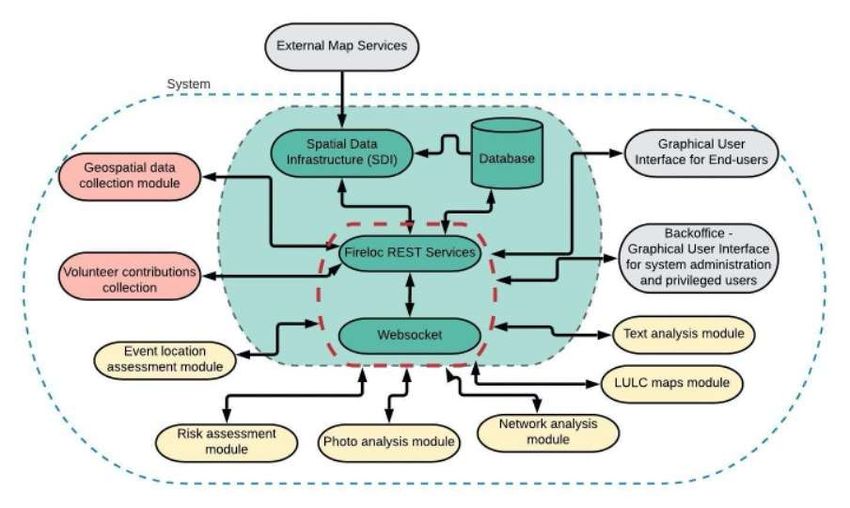
Figure 2 shows the system architecture. It includes a central core (represented inside the green
central box), modules for data collection ( in pink), modules for data processing and validation
(in yellow), and interfaces for interaction with external services and stakeholders (in grey).
Figure 2. FireLoc system architecture.
2.2.1 The Spatial Data Infrastructure
The system core is formed by: 1) a Spatial Data Infrastructure (SDI), which provides map
services and the metadata catalog and management system; 2) a database, where all data is
stored; 3) REST Services and a Web Socket, which are the central components of the system
and ensures the communication between the several modules.
The FireLoc Project: Identification, Positioning and Monitoring Forest Fires with Crowdsourced Data (11192)
Cidália C. Fonte, Alberto Cardoso, Jacinto Estima, José Paulo Almeida and Joaquim Patriarca (Portugal)
FIG e-Working Week 2021
Smart Surveyors for Land and Water Management - Challenges in a New Reality
Virtually in the Netherlands, 21–25 June 20212.2.2 The Data Collection modules
The system includes two data collection modules: 1) the automatic collection of data with
interest, such as satellite imagery or OpenStreetMap data; 2) the module that collects the
volunteer’s contributions, which is the FireLoc app.
2.2.3 The Data Processing and validation modules
The six modules for data processing and validation include: 1) a module to compute the location
of the spotted events using the collected data (Event location assessment module), namely the
location (x, y coordinates) of the observer and the bearing (angle ) towards the spotted fire (see
Figure 3); 2) a module to assess the risk associated with a fire according to its location and the
characteristics of the region, such as the relief of the region, land cover, and proximity to
population centers (Risk assessment module); 3) a module to classify the collected photographs
as showing fire, smoke or neither (Photo analysis module); 4) a module to identify the best way
to reach the fire (Network analysis module); 5) a module to collect updated Land Use and Land
Cover data, namely from satellite imagery and OpenStreetMap (LULC maps module); 6) a
module to analyze the text contributed by the volunteers and extract relevant data, such as
names of places (Text analysis module).
Figure 3. Principle of the fire location assessment with FireLoc system.
2.2.3 The Interface modules
The FireLoc Project: Identification, Positioning and Monitoring Forest Fires with Crowdsourced Data (11192)
Cidália C. Fonte, Alberto Cardoso, Jacinto Estima, José Paulo Almeida and Joaquim Patriarca (Portugal)
FIG e-Working Week 2021
Smart Surveyors for Land and Water Management - Challenges in a New Reality
Virtually in the Netherlands, 21–25 June 2021The interfaces that enable the interaction with external services and stakeholders include: 1) a
graphical user interface for end-users, which will enable users to interact with the system and
visualize the information produced by it; 2) a backoffice graphical user interface, only for
system administrators and users with privileged permissions.
Both interfaces above will enable the visualization of events reported over a map, as well as
additional information, such as the most likely event extent, the associated uncertainty and the
associated risk. However, different profile users will be considered for the visualization of the
system outputs. A simple visual glance of contributions and some information about events
over a map will be used for everyday citizens. Other profiles will also be available, including a
profile corresponding to registered members of authorities, such as civil protection, firemen or
municipalities. For these types of users, additional information will be also available, including
the uncertainty information, statistical data, and the historical information about the event
evolution.
3. PRELIMINARY RESULTS OF THE FIRELOC PROJECT
Preliminary tests were performed to assess the quality of data that will be collected by the
FireLoc app through mobile devices. The results showed that, in general, the errors in
geolocation of the observer are relatively small. Most of the time, errors are of a few meters.
However, some outliers were also obtained, where the positioning errors of the observer were
several hundreds of meters away from their correct location. On the other hand, the errors
associated with the orientation of the mobile device were much larger. These varied very much
and achieved values of tenths of degrees. Results obtained with these preliminary tests were
taken into consideration in the definition of the data collection protocol. To have additional data
to assess the quality of the collected positional and orientation measurements, the protocol for
data collection includes: 1) The continuous measurement of the device location, so that the
mean value and the standard deviation of the observer’s location can be computed; and 2) the
additional measurement of the orientation towards the user’s shadow (see section 2.1 and Figure
1).
The methodology for the photographs classification into showing fire, smoke, or none of them
followed an object detection approach, using YOLOv4 models (Bochkovskiy et al., 2020).
These models allow the location of occurrences of fire or smoke in the photo through objects
called bounding boxes. The classification process of each contribution (photo) considers a
sequence of steps, starting by identifying the parts of the images that contain fire or smoke with
boxes, and the attribution of a confidence score associated with each detected object. The
classification results are then obtained in the post-processing stage, allowing integration with
the FireLoc system and considering the Fire, Smoke and Neutral classes (Madeira, 2020;
The FireLoc Project: Identification, Positioning and Monitoring Forest Fires with Crowdsourced Data (11192)
Cidália C. Fonte, Alberto Cardoso, Jacinto Estima, José Paulo Almeida and Joaquim Patriarca (Portugal)
FIG e-Working Week 2021
Smart Surveyors for Land and Water Management - Challenges in a New Reality
Virtually in the Netherlands, 21–25 June 2021Madeira et al., 2020). Further research is still under development to improve the accuracy of
the fire or smoke detection in the uploaded photographs.
4. CHALLENGES OF THE FIRELOC PROJECT
The main constraints of the FireLoc project are:
1. The quality of data collected with the mobile devices, concerning in particular
orientation data.
2. The necessity to collect enough data to obtain reliable information on the location of
each event.
3. The ability to motivate citizens to install and use the FireLoc app, even though each
citizen may not spot fires frequently (despite the fact that in Portugal human settlements
are spread and integrated into the vegetation and natural environment). In fact, this last
point is linked to the previous one, as it is fundamental to have enough data to provide
reliable information. Therefore, the dissemination of this project will be a fundamental
aspect for its success.
The main system development challenges are:
1. The ability to accurately determine the location of fires, despite the errors that volunteer
data may have. This requires the development of a robust contribution validation
methodology, and the use of approaches to accurately locate observed events that enable
the detection and filtering of erroneous contributions that were not detected at the
contribution validation step.
2. The ability to process all data collected in real-time, so that the information may be
available in a few minutes of the aftermath of the contribution, hence enabling prompt
decision making towards fire response. These methodologies are still under
development and testing.
To assess the capability of the developed methodologies for data validation and event location,
real data are needed. The first wider campaign to collect real data will take place in the Spring
and Summer of 2021, when forest fires are more likely to occur. However, the amount of data
collected depends upon the number of people that will be available to use the app and collect
data when a fire is spotted, and of course on the number of real events occurring, which is
dependent upon several variables, including the methodological conditions of the year. The
restrictions imposed by COVID 19 pandemic may also influence data collection, if
dissemination events are not possible to undertake due to movement restrictions.
5. CONCLUSIONS AND FUTURE WORK
The FireLoc Project: Identification, Positioning and Monitoring Forest Fires with Crowdsourced Data (11192)
Cidália C. Fonte, Alberto Cardoso, Jacinto Estima, José Paulo Almeida and Joaquim Patriarca (Portugal)
FIG e-Working Week 2021
Smart Surveyors for Land and Water Management - Challenges in a New Reality
Virtually in the Netherlands, 21–25 June 2021The FireLoc system aims at helping to identify forest fires at an early stage of the fire progress by collecting and analyzing information submitted by citizens that are in the field through the developed mobile app. This will allow to automatically identify the location of fires from a few observation points. The development of the system is currently on-going with the mobile app in its final stage. An extensive data collection activity will take place during the Spring and Summer of 2021 through the mobile app. The collection of such data will enable a more complete and extensive quality analysis, which will allow to develop and test methodologies to calculate the reliability of event fire positioning approaches with real data. These data will also allow to test the methodologies developed to automatically classify the content of images depicting fire events. The FireLoc system has been planned with the Portuguese context in mind. However, the system may be applicable to any other location on Earth, as long as the data used to provide information about land-use and land-cover, orography and all other variables used for validation, uncertainty modelling and risk assessment are available. The FireLoc system was developed focusing mainly to assist in the geolocation of observed fire ignitions, and to provide data that may support a fast and informed response to fire events. However, the data collected within the FireLoc project may also be useful for post-fire activities, as it may provide information about the progress of the fire over time, and enable a better understanding of its behavior, which may contribute to the development of fire behavior models or help mapping burnt areas. ACKNOWLEDGEMENTS The project FireLoc has been supported by the Portuguese Foundation for Science and Technology (Fundação para a Ciência e a Tecnologia - FCT) under project grants PCIF/MPG/0128/2017. REFERENCES Antoniou, V., Fonte, C., See, L., Estima, J., Arsanjani, J.J., Lupia, F., Minghini, M., Foody, G.; Fritz, S. (2016). Investigating the Feasibility of Geo-Tagged Photographs as Sources of Land Cover Input Data. ISPRS International Journal of Geo-Information. Volume 5, Issue 5, 64. Bochkovskiy, A., Wang, C.-Y., Liao, H.-Y. M. (2020). YOLOv4: Optimal Speed and Accuracy of Object Detection. arXiv:2004.10934 [cs.CV]. The FireLoc Project: Identification, Positioning and Monitoring Forest Fires with Crowdsourced Data (11192) Cidália C. Fonte, Alberto Cardoso, Jacinto Estima, José Paulo Almeida and Joaquim Patriarca (Portugal) FIG e-Working Week 2021 Smart Surveyors for Land and Water Management - Challenges in a New Reality Virtually in the Netherlands, 21–25 June 2021
Chen, T., and Guestrin, C. (2016). XGBoost: A Scalable Tree Boosting System. Paper presented
   at the 22nd ACM SIGKDD International Conference on Knowledge Discovery and Data
   Mining, San Francisco, CA, USA, August 13−17.

   CICLOPE (2021). CICLOPE - Integrated large area video surveillance system. INESC INOV.
   Accessed March 25th 2021, at: https://www.ciclope.com.pt.

   Cleetus, R., Mulik, K. (2014). Playing with Fire - How Climate Change and Development
   Patterns Are Contributing to the Soaring Costs of Western Wildfires. Union of Concerned
   Scientists.          Accessed              March            25th          2021,          at:
   https://www.ucsusa.org/sites/default/files/legacy/assets/documents/global_warming/playing-
   with-fire-report.pdf

   De Albuquerque, J. P., Eckle, M., Herfort, B. and Zipf, A. (2016). Crowdsourcing geographic
   information for disaster management and improving urban resilience: an overview of recent
   developments and lessons learned. In: Capineri, C, Haklay, M, Huang, H, Antoniou, V,
   Kettunen, J, Ostermann, F and Purves, R. (eds.) European Handbook of Crowdsourced
   Geographic Information. Pp. 309-321. London: Ubiquity Press.

   Fonte, C.C., Antoniou, V., Bastin, L., Estima, J., Arsanjani, J., Laso-Bayas, J., See, L., Vatseva,
   R. (2017). Assessing VGI Data Quality. In: Foody, G., See, L., Fritz, S., Mooney, P., Olteanu-
   Raimond, Ana-Maria, Fonte, C.C., Antoniou, V. (eds.) Mapping and the Citizen Sensor.
   London. Ubiquity Press.

   Fonte, C.C., Fontes, D., Cardoso, A. (2018). A web GIS-based platform to harvest
   georeferenced data from social networks: examples of data collection regarding disaster
   events”. International Journal of Online Engineering. Volume 14, Issue 2.

   Fontes, D.; Fonte, C. C; Cardoso, A.; Estima, J.; Almeida, J. P. E. D. (2017). A platform to
   integrate crowdsourced, physical sensor and official geographic information to assist authorities
   in emergency response. In: Proceedings of AGILE 2017- 20th AGILE International Conference
   on Geographic Information Science, Wageningen.

   Futurearth (2021). Global Fires. Future Earth. Accessed March 25th 2021, at:
   https://futureearth.org/publications/issue-briefs-2/global-fires/

   Horita, F., de Albuquerque, J.P., Degrossi, L., Mendiondo, E. and Ueyama, J. (2015).
   Development of a spatial decision support system for flood risk management in Brazil that

The FireLoc Project: Identification, Positioning and Monitoring Forest Fires with Crowdsourced Data (11192)
Cidália C. Fonte, Alberto Cardoso, Jacinto Estima, José Paulo Almeida and Joaquim Patriarca (Portugal)
FIG e-Working Week 2021
Smart Surveyors for Land and Water Management - Challenges in a New Reality
Virtually in the Netherlands, 21–25 June 2021
combines volunteered geographic information with wireless sensor networks. Computers &
   Geosciences. Volume 80, pp. 84-94.

   ICNF (2020). 8º Relatório Provisório de Incêndios Rurais. Accessed March 25th 2021, at:
   https://www.icnf.pt/api/file/doc/7218b448c991d725

   Kapoor, A., Grauman, K., Urtasun, R. and Darrell T. (2007). Active Learning with Gaussian
   Processes for Object Categorization. 2007 IEEE 11th International Conference on Computer
   Vision, Rio de Janeiro, Brazil, pp. 1-8.

   Landscape News (2020). World on fire 2020: Experts explain the global wildfire crisis.
   Accessed March 25th 2021, at: https://news.globallandscapesforum.org/47794/fires-2020-
   experts-explain-the-global-wildfire-crisis/

   Liu N., Wu J., Chen H., Zhang L., Deng Z., Satoh K., Viegas D. X., Raposo J.R. (2015).
   Upslope spread of a linear flame front over a pine needle fuel bed: The role of convection
   cooling. Proceedings of the Combustion Institute, Volume 35, Issue 3, 2015, pp. 2691- 2698.

   Madeira, A. (2020). Intelligent Systems for Fire Detection. MSc thesis in Informatics
   Engineering, Faculty of Sciences and Technology, University of Coimbra.

   Madeira, A., Silva, C., Cardoso, A., Ribeiro, B. (2020). Fire and Smoke recognition in
   crowdsourced images with YOLO networks. In: 26th Portuguese Conference on Pattern
   Recognition – RECPAD 2020.

   Rego, F. (coordination) (2004). Análise da rede nacional de postos de vigia em Portugal.
   Relatório Final, CEABN/ADISA – INESC Inovação.

   Rehrl, K., Gröchenig, S. (2016). A Framework for Data-Centric Analysis of Mapping Activity
   in the Context of Volunteered Geographic Information. ISPRS International Journal of Geo-
   Information. Volume 5, Issue 3, 37.

   Rossa C.G., Davim D., Viegas D.X., (2015). Behaviour of slope and wind backing fires.
   International Journal of Wildland Fire. Volume 24, Issue 8, pp. 1085-1097.

   Schmidhuber, J. (2015). Deep Learning in Neural Networks: An Overview. Neural Networks
   Volume 61, pp. 85-117.

The FireLoc Project: Identification, Positioning and Monitoring Forest Fires with Crowdsourced Data (11192)
Cidália C. Fonte, Alberto Cardoso, Jacinto Estima, José Paulo Almeida and Joaquim Patriarca (Portugal)
FIG e-Working Week 2021
Smart Surveyors for Land and Water Management - Challenges in a New Reality
Virtually in the Netherlands, 21–25 June 2021
Senaratne, H., Mobasheri, A., Ali, A.L., Capineri, C., Haklay, M., (2016). A review of
   volunteered geographic information quality assessment methods. International Journal of
   Geographical Information Science. Volume 31, Issue 1, pp. 139-167.

   Viegas, D.X., (2012). Extreme Fire Behaviour. In: Armando C. Bonilla Cruz and Ramona E.
   Guzman Correa (Ed.), Forest Management: Technology, Practices and Impact. Nova Science
   Publishers, pp. 1-56.

   Kolden, C. (2020). Wildfires: count lives and homes, not hectares burnt. World View. Accessed
   March 25th 2021, at: https://www.nature.com/articles/d41586-020-02740-4

   BIOGRAPHICAL NOTES

   Cidália C. Fonte is a Professor at the University of Coimbra, Portugal, and a researcher and
   member of the board of Directors of the Institute for Systems Engineering and Computers at
   Coimbra since 2011. She is co-chair of the Work Group IV/4 (Collaborative Crowdsourced
   Cloud Mapping) of the International Society for Photogrammetry and Remote Sensing (ISPRS)
   since 2018 and the Portuguese representative at Commission 3 (Spatial Information
   Management) of the International Federation of Surveyors (FIG) since 2019. She coordinated
   the MSc course of Geospatial Information Engineering, between 2013 and 2019. Her main
   research interests are land use and land cover mapping based on satellite imagery; collection,
   validation and exploitation of volunteered geographic information; geospatial data quality
   assessment and uncertainty modelling.

   Alberto Cardoso is a Professor at the University of Coimbra (Portugal), senior researcher of
   the Centre for Informatics and Systems of the University of Coimbra (CISUC) and responsible
   for the Laboratory of Industrial Informatics and Systems of CISUC. He was the former
   President of the Portuguese Association of Automatic Control (APCA), President of the
   Portuguese Society for Engineering Education (SPEE), and Coordinator of the Informatics
   Engineering Chapter for the centre region of the Portuguese Engineering Association. He was
   awarded the title “International Engineering Educator Honoris Causa” by the International
   Society for Engineering Pedagogy (IGIP). He coordinates/participates in national and
   international projects (H2020 KYKLOS4.0, H2020 ReMAP, SUDOE NanoSen-AQM, FCT
   FireLoc). His main research interests are Cyber-Physical Systems, Data Analytics, Intelligent
   Systems, Sensor Data Fusion, Remote and Virtual Laboratories, Geographic Information
   Systems and Fault Tolerant Control.

   Jacinto Estima is an Assistant Professor at the Technology Department of “Universidade
   Europeia”, Portugal, and a researcher at the Information and Decision Support Systems Lab of

The FireLoc Project: Identification, Positioning and Monitoring Forest Fires with Crowdsourced Data (11192)
Cidália C. Fonte, Alberto Cardoso, Jacinto Estima, José Paulo Almeida and Joaquim Patriarca (Portugal)
FIG e-Working Week 2021
Smart Surveyors for Land and Water Management - Challenges in a New Reality
Virtually in the Netherlands, 21–25 June 2021
INESC-ID, where he works on problems related to the Geographical Information Sciences and
   Information Management, more specifically on using machine learning to extract relevant
   information from VGI data and social media. He is also an invited Assistant Professor at the
   School of Technology of Setúbal - Polytechnic Institute of Setúbal. He received his Ph.D. in
   2015 from the NOVA IMS of the NOVA University of Lisbon, in Information Management
   with specialities in Geographic Information Systems. He has been involved in several research
   and technology transfer projects addressing challenges related to the geographical information
   sciences and machine learning.

   José-Paulo de Almeida (Grad. in Land Surveying Engineering, University of Coimbra; M.Sc.
   in Civil Engineering, UC; Ph.D. in Geomatic Engineering, University College London) has
   been working at UC for more than twenty five years now, initially as Teaching Assistant and
   currently as Assistant Professor in Geomatic Engineering. He is an Associate Researcher at
   INESCC (Institute for Systems & Computers Engineering at Coimbra). He is also Portugal’s
   representative at the FIG 3D-Cadastre Working Group (Joint Sub-commission 3&7). Research
   wise, his main interests are: GIS-based processing of big geospatial data; VGI/crowdsourced
   data towards emergency event mitigation; 3D property cadastre and 3D land administration
   systems; geoBIM (integration of GIS and building information modelling).

   Joaquim Patriarca is a junior researcher of the Institute for Systems Engineering and
   Computers at Coimbra since 2016. He has been involved as a team member in several research
   projects, with contributions on the development and implementation of software based on
   geospatial analysis approaches for solving spatial problems and web geospatial applications
   and systems. His main interests are land use and land cover mapping based on the integration
   and fusion of multi-source datasets; collection, integration, validation and exploitation of
   volunteered geographic information and geospatial data; GIS software testing and performance
   optimization; WebGIS development and deployment; geospatial modelling.

   CONTACTS

   Professor Cidália Costa Fonte
   University of Coimbra, Department of Mathematics
   Apartado 3008
   3001-501 Coimbra
   PORTUGAL
   Tel. +351 239791150
   Email: cfonte@mat.uc.pt
   Web site: https://apps.uc.pt/mypage/faculty/uc22521

The FireLoc Project: Identification, Positioning and Monitoring Forest Fires with Crowdsourced Data (11192)
Cidália C. Fonte, Alberto Cardoso, Jacinto Estima, José Paulo Almeida and Joaquim Patriarca (Portugal)
FIG e-Working Week 2021
Smart Surveyors for Land and Water Management - Challenges in a New Reality
Virtually in the Netherlands, 21–25 June 2021
Professor Alberto Cardoso
   University of Coimbra, Department of Informatics Engineering
   Pólo II – Pinhal de Marrocos
   3030-290 Coimbra
   PORTUGAL
   Tel. +351 239 790 000
   Email: alberto@dei.uc.pt

   Professor Jacinto Estima
   INESC-ID
   Rua Alves Redol, 9
   1000-029 Lisbon
   PORTUGAL
   Tel. +351 239791150
   Email: jacinto.estima@universidadeeuropeia.pt

   Professor José Paulo Almeida
   University of Coimbra, Department of Mathematics
   Apartado 3008
   3001-501 Coimbra
   PORTUGAL
   Tel. +351 239791150
   Email: uc25666@uc.pt

   Joaquim Patriarca
   INESC Coimbra
   Rua Sílvio Lima, Pólo II
   3030-290 – Coimbra
   PORTUGAL
   Tel. +351 239796327
   Email: jpatriarca@mat.uc.pt

The FireLoc Project: Identification, Positioning and Monitoring Forest Fires with Crowdsourced Data (11192)
Cidália C. Fonte, Alberto Cardoso, Jacinto Estima, José Paulo Almeida and Joaquim Patriarca (Portugal)
FIG e-Working Week 2021
Smart Surveyors for Land and Water Management - Challenges in a New Reality
Virtually in the Netherlands, 21–25 June 2021
You can also read