The Geological Record - Government of Nova Scotia
←
→
Page content transcription
If your browser does not render page correctly, please read the page content below
The Geological Record
Volume 3, No. 1           Winter 2016
                                        Mineral Incentive Program Helps
In This Issue                           Prospectors with Marketing
Mineral Incentive Program Helps         The Nova Scotia Mineral Incentive Program provided $110,000 in funding to
Prospectors with Marketing              prospectors for exploration in 2015. The program also supports prospectors with
                                        marketing and promotional activities, including attendance at mining and investment
Mineral Development Proceeds under
                                        conferences such as the Mineral Exploration Roundup in Vancouver and the
Tough Economic Conditions
                                        Prospectors and Developers Association of Canada (PDAC) conference in Toronto.
Global Geopark Proposed for Parrsboro   So far this year the Marketing Grant Committee has received some very good
Shore Area                              applications, and will be providing funds and booth space to the prospectors and
                                        projects listed below.
Cobequid Highlands and Cape Breton
                                             Ted MacNaughton: Long Lake molybdenum-tungsten target. This granophile
Island Focus of Mineral Promotion at
PDAC 2016                               element prospect is a result of late-stage leucocratic greisen development in the
                                        South Mountain granite. The site features ore-grade levels of tin, bismuth, lithium
Meet the Mining ‘One Window’ Standing   and silver, as well as molybdenum and tungsten.
Committee                                    Bob Stewart: The Kell’s copper showing on the eastern Chedabucto Fault Zone
Atlantic Geoscience Society Annual
                                        is the epicenter of some great IOCG indicator minerals in the area, including copper,
Colloquium and General Meeting 2016     barite, specular hematite, siderite, ankerite and gold.
                                             Perry MacKinnon: The former Stirling VMS Mine has a new drilling target on
From the Mineral Inventory Files        the northern extension of the mine. This polymetallic mine, hosting silver and gold as
                                        well as (mostly) zinc, could be coupled with the nearby Lime Hill zinc prospect to
New Mineral Resource Land-use
Interactive Web Mapping Application     produce ore from two sources.
                                             Joe Richman: The Cape Breton Highlands gold prospect keeps getting better.
Mining Association Holds “Yes, We’re    New assays from a zone investigated this fall averaged approximately 25 g Au/t, 75 g
Open” Conference                        Au/t and 150 g Au/t. Other ore-grade material is spread over a very large zone.
Nova Scotia Contributes to National
                                             John O’Sullivan: Widow Point open pit gold target. The area near Country
Orphaned/Abandoned Mines Initiative     Harbour Gold Mines, with two past producing zones and several unexplored
                                        anomalies, makes an attractive prospect.
DNR Geohazard Risk Maps                      George O’Reilly and John MacIsaac: The Caledonia tin-tungsten prospect was
                                        found by Shell Canada Resources soon after discovery of the East Kemptville tin
Special Note/Dates to Remember
                                        deposit. No work has been done on Caledonia since 1983, but prospector John
Comments or questions? Please           MacIsaac and retired DNR geologist George O’Reilly have begun a new
contact:                                investigation of the former site, which displays ore-grade tin and tungsten.
Doug MacDonald                               John Wightman: The Dominique polymetallic granophile target consists of
Editor, The Geological Record           several anomalies that have never been well explained. Ore-grade levels of tin and
Nova Scotia Department of Natural       zinc are well documented, but now the addition of indium in this area of significant
Resources                               leucocratic alteration makes it a truly desirable exploration target.
P.O. Box 698, Halifax                        Magnum Resources: The Cobequid Highlands IOCG play, started by Minotaur
Nova Scotia, Canada B3J 2T9             Exploration, did not come to a halt when Minotaur withdrew most of its assets from
Phone 902-424-2510                      Nova Scotia. Minotaur’s regional exploration program left a wealth of information,
Douglas.R.MacDonald@novascotia.ca
                                        including a regional $2.5 million database of gravity data with many focused, drill-
                                        ready anomalies now under follow up by Magnum.
                                             If you are attending the Roundup or PDAC convention, plan to visit the
                                        Geoscience and Mines Branch booth and hear about exciting mineral opportunities in
                                        Nova Scotia.
                                        Ron Mills and Diane Webber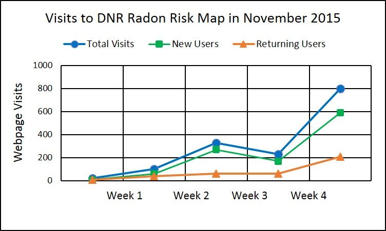
The Geological Record                                                                                            Winter 2016

Mineral Development                          Global Geopark Proposed for Parrsboro
Proceeds Under                               Shore Area
Tough Economic
                                             It’s official. Nova Scotians are pursuing a UNESCO Global Geopark for the Parrsboro
Conditions                                   shore area. In December 2015, the Cumberland Geological Society, the community
                                             group that administers the Fundy Geological Museum, submitted a letter of intent to
Kameron Collieries, a subsidiary of the      the National Committee for Global Geoparks. The committee reports to the Canadian
Cline Group LLC, is gearing up to enter      Federation of Earth Sciences and is the agency responsible to direct applications for
a ‘test mining’ phase at the Donkin          Global Geopark status to the Canadian Commission for UNESCO.
property in Cape Breton. This could               Global Geoparks are found in 35 countries, concentrated at present in Europe and
involve the extraction of up to 1.0          Asia. Global Geoparks are based on bottom-up, community-driven management and
million tonnes over two years from the       economic development. Unlike municipal, provincial and national parks, geoparks do
Harbour Seam, extending out under the        not carry land-use restrictions. Instead, they are a vehicle to bring attention to a
Atlantic Ocean. The test will determine      region’s geology and mining history. Combine the Cumberland Geological Society’s
the characteristics of the seam, evaluate    established track record with some of the most spectacular coastal geology found
the proposed mining method and confirm       anywhere, and the future looks bright for geotourism on the Fundy shore.
the quality and marketability of the coal.
Depending on the results, a full-scale       John Calder
operation might be justified.
     In addition to the coal project,
government approvals are being sought
for three other mine developments in the
province.
     Black Point Aggregates Inc. is
seeking joint federal/provincial
Environmental Assessment approvals for
a large (1 to 7.5 million-tonne-per-year)
construction aggregate quarry at Black
Point near Canso. The public comment
period closed on February 3, 2016, on
the draft Environmental Assessment
Report. Black Point Aggregates Inc. is a
subsidiary of U.S.-based Vulcan
Materials Co.
     DDV Gold is seeking approvals for
a 5,500 tonnes-per-day open pit gold
mine at Beaver Dam in Halifax County.
DDV, which is a subsidiary of Atlantic
Gold Corporation, already has the
necessary approvals to commence
                                             In photo, left to right: Oralee O'Byrne, Treasurer, Cumberland Geological Society
development of an open pit gold mine,
                                             (CGS) and Curator, Age of Sail Museum; Karen Dickinson, Chair, CGS; Lois Smith,
processing facility and tailings             Vice Chair, CGS; Leisa Babineau, Mayor of Parrsboro and Administrator, Fundy
management facility at Moose River (the      Geological Museum; Lawrence Nicolls, Board Member, CGS; Eric Leighton, Board
Touquoy project). It is presently seeking    Member, CGS; John Calder, NSDNR; Robert Grantham, Board Member, CGS.
about $137 million to finance that
project. Once mined out, the Touquoy pit
would then hold tailings that would be
generated from the processing of gold        develop a new tin-indium mine at the        Avalon, the company intends to release
ore trucked to the site from the Beaver      site of the former East Kemptville tin      a Preliminary Economic Assessment
Dam property, 37 km distant. The draft       mine in Yarmouth County. That open          that will evaluate a number of
Environmental Impact Statement for the       pit mine and mill closed in 1992 due        development scenarios for the mineral
Beaver Dam project is in progress.           to low metal prices and the site has        deposits.
     At the southern end of the province,    been reclaimed. Once full title to the
Avalon Rare Metals Inc. is working to        property has been transferred to            Patrick Whiteway

                                                                                                                        Page 2
The Geological Record Winter 2016
Cobequid Highlands and Cape Breton Island are the Focus of
Mineral Promotion at PDAC 2016
The Geological Services Division is zones. The Humber Zone represents the the Exploits subzone in Newfoundland,
adopting a new approach to promoting leading edge of Laurentia’s margin; the which host numerous VHMS deposits.
the mineral potential of Nova Scotia at Gander, Avalon and Meguma zones Significant gold vein deposits on Cape
the Prospectors and Developers Associa- represent peri-Gondwanan microconti- Breton Island are associated with a major
tion of Canada (PDAC) convention in nents that were sequentially accreted to mylonitic high-strain zone known as the
Toronto this March. Our focus is on Laurentia. The Dunnage Zone mainly Eastern Highlands Shear Zone and may
highlighting new research and discovery contains accreted arc terranes and has be similar to the vein gold deposits asso-
in the field by DNR geoscientists. This been subdivided into the peri- ciated with brittle-ductile faults in the
year we are highlighting work conducted Laurentian Notre Dame and peri- Cape Ray area of Newfoundland.
over the last several years as part of the Gondwanan Exploits subzones. The Avalonia contains several types of
projects to remap the Cobequid High- Appalachian orogen is rich in volcanic- mineral deposits that formed before its
lands and parts of Cape Breton Island, hosted massive sulphide (VHMS) late Silurian accretion to Laurentia. The
and to compile the many datasets availa- deposits and, to a much lesser extent, oldest are several VMS deposits that are
ble for these regions. sediment-hosted massive sulphide de- hosted by Late Neoproterozoic arc vol-
Due in part to the deficiencies of posits. Most of the host rocks to the canic rocks and include the Winter Hill
existing maps, the Cobequid Highlands sulphide deposits formed in subduction and Frenchman Head deposits
have been an underexplored, geologically zones related to the closure of the (Newfoundland), the Stirling deposit
complex region. Recent work has result- oceans and back arcs between the peri- (Mira terrane - Cape Breton Island), and
ed in many new discoveries, including a Laurentian and peri-Gondwanan arc the cupriferous Teahan and Lumsden
regional-scale IOCG play, rare-earth ele- terranes, especially in the Notre Dame deposits (Broad River Group - New
ment (REE) potential, and occurrences of and Exploits subzones in Newfound- Brunswick). Associated calc-alkaline
low-sulphidation epithermal gold. These land and New Brunswick. plutonic rocks host disseminated Cu and
discoveries have been made through a Many of the same units are present Mo porphyry in Newfoundland (e.g. Hol-
combination of new mapping by DNR in Cape Breton Island, yet this part of yrood Granite) and Cape Breton Island
and renewed industry exploration. Nova Scotia remains underexplored. (e.g. Coxheath Hills pluton). Pyrophyllite
In an effort in invite further explora- Work on a new series of 1:50 000-scale alteration zones developed in predomi-
tion, the Geological Services Division geological compilation maps of the nantly felsic volcanic rocks throughout
will display a poster highlighting the new island has sparked a renewed interest in the Avalon Zone in Newfoundland are
mapping, as well as the many datasets exploring the economic potential of the associated with epithermal gold and
available to industry and the public. area. The Faribault Brook area in west- silver mineralization. This alteration has
These datasets include geochemical data ern Cape Breton Island hosts several also been recently noted in the Mira
from DNR’s portable XRF unit on over Cu-Pb-Zn-Au occurrences and histori- terrane in Cape Breton Island and has
5,000 bedrock samples, regional surficial cal mines. Recent detailed mapping largely been unexplored.
geochemistry, high-resolution lidar, and together with lithogeochemical and U-
regional geophysical surveys including Pb dating in this area has shown these Chris White, Geoff Baldwin and Trevor
airborne magnetics, radiometrics and host rocks are correlative to those in MacHattie
gravity surveys. Almost any type of sur-
vey in recent years has led to new discov-
eries. With further exploration invest-
ment in the Cobequid Highlands, the
potential for the discovery of a major
mineral deposit is very high.
The Canadian Appalachian orogen
(Fig. 1) extends from Newfoundland
through Nova Scotia, Prince Edward
Island and New Brunswick into southern
Quebec, and has been subdivided into
several tectonostratigraphic zones that
constitute a complex collection of micro-
continents and associated volcanic arcs.
From west to east, these are the Humber,
Dunnage, Gander, Avalon and Meguma Figure 1. Sketch map of the northern Appalachian orogen.
Page 3The Geological Record Winter 2016
Meet the Mining Atlantic Geoscience Society (AGS) Annual
‘One Window’ Colloquium and General Meeting 2016
Standing The 42nd Atlantic Geoscience Society (AGS) Colloquium and Annual General
Meeting were held at the Holiday Inn, Truro, on February 5 and 6, 2016. The
Committee organizers, Tim Fedak, Bob Grantham, Rob Raeside and Chris White, with help from
Ian Spooner and numerous student volunteers, facilitated an excellent meeting. About
Authorities responsible for administering 170 registered participants enjoyed a full and diverse program. As usual, the event
regulations related to mineral was well attended by employees (both former and current) of the Nova Scotia
development activity in Nova Scotia Department of Natural Resources, who also contributed to several of the sessions.
meet once a month to discuss active Thanks are extended to Howard Donohoe for acting as the AGS special events
projects and to exchange information photographer.
related to approvals. Members of the Friday’s program began with a workshop on QA/QC in Geology Research and
Mining ‘One Window’ Standing Exploration by Cliff Stanley (Acadia University). Poster displays started Friday
Committee are pictured below at their evening and remained available to view until late Saturday afternoon. Three
December 2015 meeting. Seated (from L concurrent sessions ran Friday evening: Recent Research in Petrology and
to R) are Cyril LeBlanc, Mining Geophysics; Recent Research in Sedimentary and Surficial Geology; and Dates, Rates
Engineer, Labour and Advanced and Duration of Tectonic Processes-Timing is Everything.
Education, Occupational Health and Saturday’s events started with several concurrent sessions including Tin-related
Safety; Beata Dera, Policy Analyst, Mineralization and Exploration in the Maritimes; Geoscience Education and
Office of Aboriginal Affairs; and Tom Outreach: Creating an Awareness; Offshore Geology of Eastern Canada; Recent
Lamb, Mining Engineer, Geoscience and Research in Economic Geology; and Advances in Carboniferous Geology in the
Mines Branch, DNR. Standing (from L to Atlantic Provinces. The guest speaker at Saturday evening’s banquet was Gerald
R) are John MacNeil, Registrar of Gloade (Mi’kmaq artist from Millbrook and Program Officer at Mi’kmawey Debert
Mineral and Petroleum Titles, Cultural Centre) who gave an informative and entertaining presentation on Mi’kmaq
Geoscience and Mines Branch, DNR; legends in Atlantic Canada and the intertwined relationship between Glooscap and
Patrick Whiteway, Manager of Mineral geology. Following dinner several prestigious AGS awards were presented in
Development and Policy, Geoscience and recognition of worthy student presentations and professional accomplishments.
Mines Branch and Chair of the One $The new Rob Raeside Award for best undergraduate student poster went to Lori
Window Committee; Joseph Vigder, Paslawski (St. Francis Xavier University) and her co-authors Alan J. Anderson,
Environmental Assessment Officer, Christopher MacFarlane and Brandon Boucher.
Canadian Environmental Assessment $The Graham Williams Award for best graduate student poster went to Cody A.
Agency; and Helen Yeh, Environmental Paige (Dalhousie University).
Assessment (EA) Analyst, EA Branch, $The Rupert MacNeill Award for best undergraduate student oral presentation went
Nova Scotia Environment. to Christopher Sangster (Saint Mary’s University) and his co-authors Georgia Pe-
Piper and Yuanyuan Zhang.
Patrick Whiteway $The Sandra Barr Award for best graduate student oral presentation went to Travis
McCarron (University of New Brunswick) and his co-authors Chris McFarlane and
Fred Gaidies.
$The Encana Prize for best student poster in the Offshore Geology of Eastern Canada
session went to J. Carlos Wong (Dalhousie University) and his co-authors Carla
Skinner, Bill Richards, Ricardo Silva, Natasha Morrison and Grant Wach.
$The Encana Prize for best student oral presentation in the Offshore Geology of
Eastern Canada session went to Isabel Chavez (Saint Mary’s University) and her co-
authors David Piper, Georgia Pe-Piper and Yuanyuan Zhang.
$The Laing Ferguson - Distinguished Service Award, given in recognition of
exceptional and altruistic contributions to the Atlantic Geoscience Society and/or to
foster public appreciation of Atlantic geoscience over a long period of time, went to
Chris White (Nova Scotia Department of Natural Resources).
Members of the Mining One Window $The Distinguished Scientist Award - Gesner Medal, given to a person who
Standing Committee gathered for a
developed and promoted the advancement of geoscience in the Atlantic Region in
regular monthly meeting in December
2015. The Mineral Development and any field of geology, was awarded to Dave Lentz (University of New Brunswick).
Policy section of DNR’s Geoscience and Thanks to the organizers and all of the participants for an outstanding weekend!
Mines Branch leads the One Window
process. Chris White
Page 4The Geological Record Winter 2016
From the Mineral Inventory Files
Tragedy at Gold Lake
Researching and field checking old Times that reads: “Three Men Killed in first development effort, and it was during
mineral prospects and mines isn’t always Halifax; Boiler Bursts at the Gold Lake testing of the boiler that the accident
just about geology. Often the research Mines with Fatal Results. Halifax, N.S. occurred.
provides a window into long-past eras, Nov. 26 – The explosion of a boiler at When I first visited the mine in 1997,
the conditions workers faced and the Gold Lake Mines, East Halifax, today by coincidence almost 100 years to the
routine of their everyday lives. In the late caused the instant death of the day following the explosion, I found a
1800s working in the woods was tough manager of the mine, Daniel McPhail, few foundations and some quartz debris
and conditions were harsh. Protecting the and two other men, James Hennessy at the very southeast corner of Gold Lake
health and safety of workers was mostly and John McIsaac, their bodies being (Fig 1). I also came upon the remnants of
an afterthought. Edmund Burke offered terribly torn by the flying wreckage of a boiler and, 30 m to the south, the
the opinion that “those who don’t know the boiler. No others were seriously boiler’s firebox. Now overgrown, both
history are doomed to repeat it,” so let’s injured. Hennessy and McIsaac were pieces were extensively damaged (Fig. 2).
examine a piece of Nova Scotia’s history. testing the boiler at the time.” The twisted condition of the firebox
Tragedy struck on 26 November The Gold Lake Mine was a small particularly shows the power of the
1897 at the Consolidated Gold Lake Au operation. Discovered in 1867, but not explosion. In addition, the surrounding
Mine northeast of Lake Charlotte, developed until the mid-1890s, it only area is strewn with twisted pieces of
Halifax County (Fig. 1). The only official ever produced a few dozen ounces of metal, including many fragments of boiler
record of the accident I know of is a short gold from a handful of shafts (Fig. 1). pipe showing steam-pressure ruptures
article in the November 27 New York Installation of a boiler was part of this (inset in Fig. 2). The accident site seems
to have been left essentially as it was
following the 1897 explosion.
Government reports show no formal
record of this accident and the loss of
three men. Times really have changed.
George O’Reilly
Figure 1. (L) Air photo showing the location of the Gold Lake Mine and position of the 1897 boiler accident relative to the mine
workings. Figure 2. (R) Photo of the boiler firebox showing extensive damage. The inset is a photo of a ruptured pipe from the boiler,
showing clear evidence of the steam explosion.
Page 5The Geological Record Winter 2016
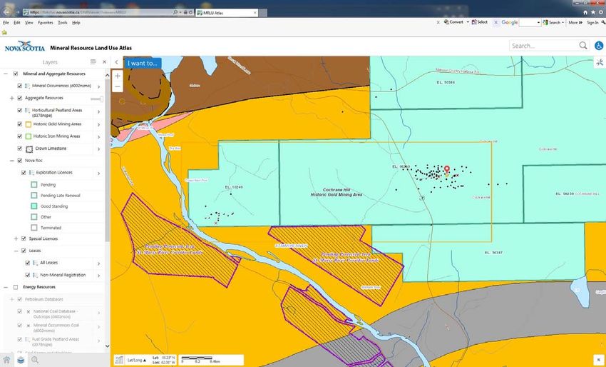
New Mineral Resource Land-use Interactive Web Mapping Application
A new version of the Mineral Resource Land-use Atlas (MRLU) interactive web mapping application is now available on the branch
web site. This is the sixth web mapping application that the Geoscience and Mines Branch has recently released on new servers and
with current interactive map-server technology.
The MRLU application was modelled after the MRLU Map Atlas published in 2000 (Open File Map ME 2000-004) by David
Hopper, Fred Bonner and Brian Fisher. The atlas consisted of 98 maps (scale of 1:50 000) that covered the entire province. A second
version of the map atlas and a digital product were published in 2002 with revised base layers and the latest version of the Restricted
and Limited Use Land Database. The first version of an MRLU online interactive map application was released in 2004 and has been
running since then. In 2014 the old map service behind the MRLU application generated nearly 124,000 maps.
The new MRLU application provides the public, land-use planners, geotechnical firms and groups involved in community
economic development with a single georeferenced compilation of information related to mineral resource land use at a reasonably
detailed scale. This application displays the location and distribution of mineral and energy resources, and related activities. The
information also includes environmental geology and geohazards that relate to land-use and environmental planning.
Along with a new application, many of the layers within the MRLU application have been augmented. This includes 30
restricted, conditional and limited-use lands that are important to mineral resource interests. These include provincial and national
parks, wildlife areas, sanctuaries and reserves. These same layers will have utility in other areas of land-use planning, such as
municipal planning and economic development.
The team developing the new applications has designed a common ‘look and feel’ to help users navigate through these complex
databases. Continuing improvements to all applications will be introduced whenever possible, so expect this technology to evolve in
the future. The new MRLU application is found on the Geoscience and Mines Branch interactive maps page: http://novascotia.ca/
natr/meb/geoscience-online/maps-interactive.asp.
Jeff Poole, Sonya Cowper and Brian Fisher
An example of the interface for the new Mineral Resource Land-use Atlas. In this case the Cochrane Hill gold mining area is shown
with drillholes, mineral occurrences and abandoned mines, along with current exploration licences, bedrock geology and protected
areas.
Page 6The Geological Record Winter 2016
Mining Association Nova Scotia Contributes to National
Holds “Yes, We’re Orphaned/Abandoned Mines Initiative
Open” Conference In 2016, an online interactive map opportunity for the group to visit one of
The Mining Association of Nova Scotia showing the location of thousands of the oldest abandoned mine sites in the
(MANS) completed a report in August orphaned and abandoned mines in country and to discuss the challenges of
2015 about how the mining industry, Canada will be launched by the remediating these sites. The site chosen
both here and elsewhere, views Nova National Orphaned/Abandoned Mines was the gold mining district in
Scotia as a place to invest. The report, Initiative (NOAMI). Nova Scotia is Montague, which was mined from 1863
Sorry, we're closed: how the province's contributing to this map by providing to 1940, located 20 km northeast of
reputation in the global mining industry data on 825 such sites – mainly Halifax. The field trip was organized by
is costing Nova Scotians jobs, includes historical gold, coal, gypsum and iron Dr. Michael Parsons, Research Scientist,
interviews with dozens of industry ore mines. The Geoscience and Mines Environmental Geochemist for the
leaders and provides examples of policy Branch compiled the data from its Geological Survey of Canada with
issues that, if resolved, would send a existing Abandoned Mine Openings assistance from Ernie Hennick of the
signal to the global mining industry that database and various Open File and Geoscience and Mines Branch.
Nova Scotia is open for business. Economic Geology Series reports. This site is one of thousands in Nova
To help address the issues detailed The NOAMI Advisory Committee Scotia that are monitored and remediated
in the report, MANS planned a half-day consists of representatives from most by the Geoscience and Mines Branch as
conference – the “Yes, We’re Open” provinces and territories. They meet on part of our Abandoned Mine Openings
conference – at which industry and a regular basis by teleconference, but program. Members of the NOAMI
government representatives could come on July 22, 2015, members met face-to- committee are pictured here at the
together to discuss the report and work face in Halifax on the fringes of the Montague site.
together constructively. The conference, annual Energy and Mines Ministers’
held on November 19, 2015, included Conference. This afforded an excellent Patrick Whiteway and Ernie Hennick
speakers from both industry and
government, such as the Honourable
Mark Furey, Minister for Business, and
Frank Dunn, Deputy Minister for the
Department of Natural Resources.
One of the recommendations in the
Sorry, we’re closed report, and an issue
heard often during interviews with
industry leaders and executives, is that
Nova Scotia should lift the uranium ban.
To help address the misconceptions
around uranium mining, MANS brought
in Jean LeClair, Director, Uranium
Mines and Mills Division from the
Canadian Nuclear Safety Commission to
explain how uranium mines are
stringently regulated in Canada.
The dialogue was constructive and
helped both sides understand the issues
and how to work better together. The
“Yes, We’re Open” conference focused
on solutions and how, together, we can
send the message to the global mining
industry that Nova Scotia is open for
business.
Sarah Kirby
Director, Government Relations and Geoscience and Mines Branch summer student Daniel O’Brien (left) assists GSC
Communications geochemist Michael Parsons (centre) to guide members of the NOAMI Advisory
Mining Association of Nova Scotia Committee around the abandoned gold-mining site of Montague.
Page 7The Geological Record Winter 2016
DNR Geohazard Risk Maps Special Note
There are several naturally occurring chemical geohazards in Nova Scotia that can E-mail Notification
pose a risk to human health and the environment. Examples include radon gas, which
If you would like to receive an e-mail
can accumulate in indoor air; arsenic and uranium, which can migrate in groundwater
notice (with hot links) when new maps,
and affect well water; and acid rock drainage (ARD), which can pose a risk to aquatic
digital products and publications are
habitats. Radon gas is estimated to affect 11% of all homes in the province and arsenic
and uranium are estimated to affect 9% and 4% of private water wells, respectively. released, or when a new issue of The
Many chemical geohazards cannot be identified without laboratory testing Geological Record is released, please
because they have no taste, odour or colour to warn of their presence. In these cases, send your e-mail address to
what you don’t know can hurt you. Therefore, risk mapping and public awareness are DNR.Library.List@novascotia.ca.
essential to protecting public health and the environment.
DNR has published a series of geohazard risk maps and continues to update and
publish these in new user-friendly formats. Risk maps for sinkhole occurrence and
Dates to Remember
arsenic in well water are currently being worked on, and the current trend is to publish
geohazard maps in online interactive formats. DNR’s radon risk map and ARD risk March 6-9, 2016
map are already available in this format. Interactive maps are powerful public Prospectors and Developers Association
engagement tools because they are easy to use and their interactive nature attracts of Canada, International Convention,
attention by homeowners who are curious to see what risk levels are present in their Trade Show & Investors Exchange,
neighbourhood. Metro Toronto Convention Centre,
An example of the impact of interactive risk maps combined with public outreach Toronto, ON. For more information
activities can be seen in the accompanying graph, which shows the number of visits to please visit the web site: www.pdac.ca/
DNR’s radon map during the month of November 2015. November is Canada’s convention.
Radon Action Month and during this time there were numerous media stories about
radon and public events, including one at the Halifax Central Library, which DNR April 21, 2016
participated in. The graph shows a steady increase in the use of the radon map Mining Association of Nova Scotia
throughout November, with a total of 1,452 sessions logged by the end of the month. Annual General Meeting and Reception,
Although the radon map can improve risk awareness, it is important for homeowners Inn on the Lake, 3009 Highway 2, Fall
to follow up with radon testing and remediation to reduce radon exposure. The River, NS. Members in good standing
interactive map includes links to information on how to purchase test kits and how to are invited to the AGM from 3-4 pm; all
find certified radon contractors for remediation work. Please visit the map here: are invited to the reception from 4-6 pm.
https://fletcher.novascotia.ca/DNRViewer/?viewer=Radon. For more information please contact
John Drage Sarah Kirby: sarah@tmans.ca.
June 1-3, 2016
Geological Association of Canada-
Mineralogical Association of Canada
2016: Margins through Time, Yukon
College Campus, Whitehorse, YT. For
more information please visit the web
site: whitehorse2016.ca/.
June 9 and 10, 2016
Mining Society of Nova Scotia 129th
Annual Meeting, Marriott Halifax
Harbourfront, Halifax, NS. For more
information please visit the web site:
http://www.miningsocietyns.ca/.
August 19-21, 2016
Nova Scotia Gem and Mineral Show and
Sale, Parrsboro, NS. For more
November 2015 was Canada’s first National Radon Action Month. The number of visits information please visit: https://
to the Geoscience and Mines Branch web site to view the interactive radon risk map fundygeological.novascotia.ca/
reflects the attention this geohazard received in the media and through public events. gemshow.
Page 8You can also read