The heritage of the Second World War: bombing in the forests and wetlands of the Ko źle Basin
←
→
Page content transcription
If your browser does not render page correctly, please read the page content below
Antiquity 2021 Vol. 95 (380): 417–434
https://doi.org/10.15184/aqy.2020.154

Research Article

The heritage of the Second World War: bombing in
the forests and wetlands of the Koźle Basin
Jan M. Waga1 & Maria Fajer1,*
1
 Faculty of Natural Sciences, University of Silesia in Katowice, Poland
* Author for correspondence: ✉ maria.fajer@us.edu.pl

                                                            The Koźle Basin in Poland was radically transformed
                                                            by aerial bombardment during the Second World
                                                            War. Today, the region has approximately 6000
                                                            well-preserved bomb craters with diameters ranging
                                                            from 5–15m and depths often exceeding 2m.
                                                            Combining remote-sensing data and fieldwork with
                                                            historical accounts, this article analyses these craters,
                                                            demonstrating that their varied morphologies derive
                                                            from the weight of the bombs that created them,
                                                            and on the type and moisture content of the soil
                                                            on which the bombs fell. Based on their results, the
                                                            authors issue a call for the official protection of
                                                            the Koźle landscape, which has particular historical,
                                                            educational and ecological value.

    Keywords: Poland, Second World War, bomb craters, cultural heritage protection

Introduction
In the Koźle Basin in southern Poland (Figure 1), many features of the contemporary
landscape attest to past military activities. Indeed, the Basin is one of the most radically
transformed landscapes in Europe as a result of aerial bombardment during the 1940s. At
that time the Koźle Basin was part of Germany. In the final phase of the Second World
War, the U.S. Air Forces used a variety of ordnance to destroy fuel plants in the area:
500lb (227kg) and 250lb (113kg) demolition bombs, 500lb and 250lb general-purpose
bombs, and 250lb and 70lb (32kg) incendiary bombs (Craven & Cate 1983; Asch et al.
1991; Ehlers 2009).
   Most archaeological research on areas similarly transformed by artillery shells or bombs
dropped from aircraft concentrates on northern France, Belgium and the Netherlands, and

Received: 11 February 2020; Revised: 19 June 2020; Accepted: 2 July 2020
© The Author(s), 2021. Published by Cambridge University Press on behalf of Antiquity Publications Ltd. This is an
Open Access article, distributed under the terms of the Creative Commons Attribution licence (http://creativecommons.
org/licenses/by/4.0/), which permits unrestricted re-use, distribution, and reproduction in any medium, provided the
original work is properly cited.

                                                        417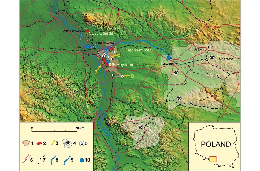
© The Author(s), 2021. Published by Cambridge University Press on behalf of Antiquity Publications Ltd

                                                                                                                                                                                                                                                                                                     Jan M. Waga & Maria Fajer
418

                                                                                                               Figure 1. Site map of the Koźle Basin: 1) area with bomb craters; 2) former synthetic fuel plant; 3a) study area; 3b) flak battery near Dziergowice; 3c) former foresters’ lodge in
                                                                                                               Dab̨ rowa; 4) coal-mining area; 5) flak battery; 6) roads; 7) railway line; 8) river; 9) canal; 10) port (figure by Jan Maciej Waga, digital elevation model prepared by Jerzy Nita).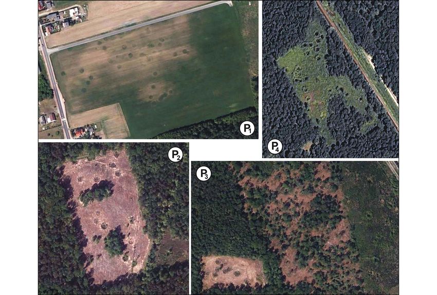
The heritage of the Second World War: bombing in the Koźle Basin

includes descriptions of craters from both the First and Second World Wars (e.g. Passmore
et al. 2014, 2018; Capps-Tunwell et al. 2016, 2018; de Matos-Machado et al. 2019; van der
Schriek 2019; Passmore & Capps-Tunwell 2020). In Poland there has been relatively
little research on such landscapes (see Kobiałka 2017, 2018). Over the past decade or so,
researchers have paid particular attention to the role of lidar image analysis and other
detection methods in studying former battlefields—especially those that are now covered
by dense vegetation (e.g. Hesse 2010; Passmore et al. 2014; van der Schriek & Beex
2017; Brenner et al. 2018; Gheyle et al. 2018; Clermont et al. 2019; Kruse et al. 2019;
de Matos-Machado et al. 2019; Note et al. 2019; Passmore & Capps-Tunwell 2020).
    The aim of this article is to present research on craters that highlights the massive aerial
bombing of local industrial plants in the Koźle Basin in 1944, along with the craters’
morphological and morphometric characteristics. We present the first investigation of
an intensively bombed Polish landscape, which offers an important contribution to the
field of conflict archaeology. The results will, among other outcomes, inform appropriate
decisions concerning the protection of these craters as both a cultural and natural heritage
landscape.

Methods and materials
We have mapped the distribution of individual craters within the study area through the ana-
lysis of a shaded relief map generated from extant lidar data (resolution 4pts/m2, lit from the
315° azimuth; map based on data from www.polska.e-mapa.net). The diameter of each crater
has been documented using a distance and surface area measurement application. We sought
to establish the dimensions of the craters before they were transformed by human or animal
activity (e.g. by animals accessing the water within or by boar wallows).
    Crater diameters depend not only on the mass of bombs dropped and the type of fuses
used, but also on the geological and hydrological conditions of the ground. Our analysis of
the size and shape of craters was therefore focused on areas within each similar
geo-environmental feature. These comprise Pleistocene and Holocene terraces formed
from mineral river sediments, aeolian sand fields, and peaty wetlands and oxbow lakes.
Using remote sensing and field observations, detailed measurements of craters located in
these areas were collected and the state of each crater’s preservation determined. Field
measurements were taken using a GPSMAP 62st receiver and Nikon Forestry Pro laser
rangefinder with an optical viewfinder and a level staff. Bathymetric measurements of
water bodies in the craters were also taken using a scaled telescopic arm with measuring
tape and weight, with readings taken using binoculars. A manual geological probe was
used to identify geological conditions on the walls of deeper craters in existing excavations
(e.g. drainage ditches, sandpits, footings) and also in safe zones clear of unexploded bombs.
We also made use of geological, hydrographic, soil and sozological (i.e. environmental con-
ditions) maps and data from the Geological Database of the Polish Geological Institute.
    In addition, we analysed archival mission reports and publications from the Air Force His-
torical Research Agency website (https://www.afhra.af.mil), the National Archives (https://
www.archives.gov) and The Fifteenth Air Force (https://15thaf.org), as well as scientific

        © The Author(s), 2021. Published by Cambridge University Press on behalf of Antiquity Publications Ltd
                                                   419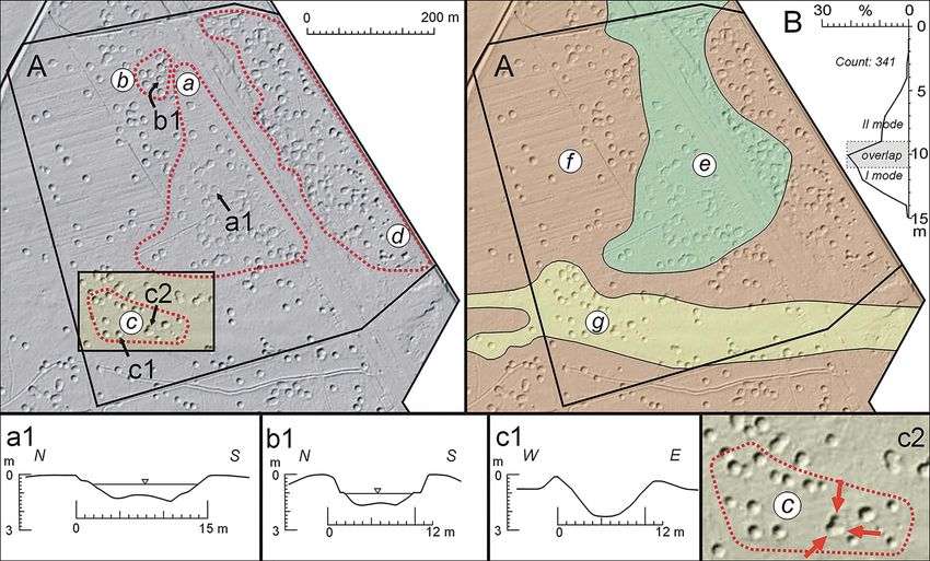
Jan M. Waga & Maria Fajer

literature on the Allied air offensive against the Third Reich and other sources that document
warfare in Silesia and its material remains.

Study area
The study area lies to the south of Ked̨ zierzyn Koźle in Poland (3a on Figure 1), within the
Koźle Basin that forms part of the Silesian Lowland. In the Koźle Basin sandy levels associated
with the deglaciation of the Odra ice-sheet, as well as a system of six sandy river terraces, are
present. On the right bank of the Odra River, large alluvial fans correspond to the location of
the most extensive Vistulian (Weichselian) terrace. Almost the entire area of the Koźle Basin is
covered by Quaternary sediments. Fifty per cent of the Basin is covered with a layer of aeolian
sands, the thickness of which ranges from several dozen centimetres to 2m, and numerous
dunes are present. The extensive presence of sand in the Koźle Basin has resulted in the devel-
opment of podzolic and rusty (Brunic Arenosol) soils (www.polska.e-mapa.net), which are
covered with forests. In many places, water is present either on the surface of sandy, silty ter-
races or as a shallow water table, and drains via ditches to the rivers.
   Air masses often stagnate in the Koźle Basin, but as it is open to the north-west, it can be
ventilated rapidly depending on the direction of wind. During the Second World War, these
topoclimatic conditions were used most effectively by the Germans for deploying anti-aircraft
smoke screens (Konieczny 1998; Mahoney 2013). The defensive characteristics of the area
(which is, importantly, covered by woods that further concealed German activity) were
enhanced by the fact that it was sheltered by hills, which surrounded it in a horseshoe
shape (Figure 1). By the 1930s the Koźle Basin already benefitted from an efficient transport
infrastructure, comprising a large railway junction, a river port, the regulated Odra River, the
Gliwice Canal and a network of good-quality roads. Raw materials in the form of coal and
water resources were also available nearby (Figure 1).

The German chemicals and fuel industry in the 1930s and 1940s
The German war plans of the 1930s placed an emphasis on mechanised units, which
increased the demand for fuels, oils and lubricants. As a result, the construction of
hydrocarbon-production plants commenced at several sites. Due to the convenient location
(both environmental and economic) of the Koźle Basin, a decision was made to construct the
Third Reich’s largest fuel production plants near Heydebreck (now Ked̨ zierzyn) (Ehlers
2009; Figure 1). The Schaffgotsch Benzin Werke GmbH Odertal plant (SBW on Figure 1)
had already been commissioned in 1939. The construction of the Oberschlesische Hydrier-
werke AG Blechhammer and IG Farbenindustrie AG Werke Heydebreck plants commenced
in late 1939, and fuel production at both these plants started in early 1944. The target output
was 350 000 tonnes of fuel per year for Blechhammer and 300 000 tonnes for Heydebreck.
The plant in Odertal (now Zdzieszowice) could produce up to 80 000 tonnes of fuel per year.
Due to technical difficulties and the impact of bombing by the 15th United States Air Force
(USAF), however, these planned levels of output were never achieved (Konieczny 1998;
Haduch n.d.).

© The Author(s), 2021. Published by Cambridge University Press on behalf of Antiquity Publications Ltd
                                                     420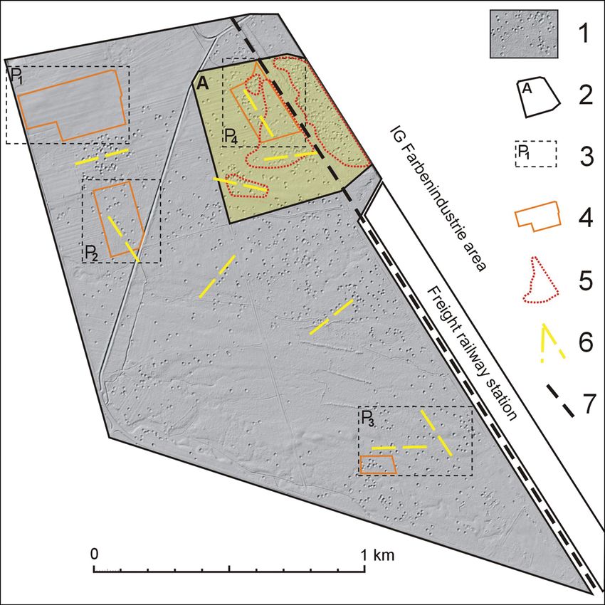
The heritage of the Second World War: bombing in the Koźle Basin

Allied combat operations and the German defence of chemical and
fuel plants
In January 1943, the Western Allies planned attacks by Royal Air Force (RAF) Bomber Com-
mand and the 8th USAF against German oil refineries and synthetic petrol plants. In Sep-
tember 1943, after the Foggia region of southern Italy had been occupied by the Allies
(Holland 2018), the 15th USAF began to assemble in this area. From 20 February 1944,
as part of the ‘Big Week Offensive’, the 8th and 15th USAF, together with the RAF, launched
frequent attacks on selected ground targets and proceeded to exhaust the combat capabilities
of the German forces (Holland 2018). At the beginning of May 1944, the Americans and the
British launched highly effective attacks against five synthetic fuel plants in central Germany,
with further heavy bombardment following on 28 and 30 May (Konieczny 1998).
    The Germans reinforced the defence of the Koźle plants by, among other precautions,
installing anti-aircraft artillery, laying smoke screens and constructing air-raid shelters. Due
to the high ceiling from which the US B-17 and B-24 bombers dropped their loads
(6700–8900m), however, only high-powered anti-aircraft batteries were able to shoot
down enemy aircraft (Fifteenth Air Force 1944; Craven & Cate 1983; Levine 1992).
    On 8 June 1944, a directive was issued to the 8th and 15th USAF to prioritise attacks against
fuel industry facilities. The plants at Blechhammer, Heydebreck and Odertal in the Koźle Basin
were allocated to the 15th USAF (Craven & Cate 1983). By September 1944, despite large
losses, the Western Allies managed to reduce fuel production at German refineries to just
eight per cent of the April level (Konieczny 1998). On 7 July 1944, large-scale bombardment
of fuel factories in the Heydebreck area began; of the 18 raids, 15 directly targeted the Blech-
hammer and Heydebreck factories (Asch et al. 1991; Carter & Mueller 1991; Mahoney 2013).
After the first attack, the Germans stationed their anti-aircraft batteries close to the industrial
plants. Earthworks representing seven such batteries survive today (Figure 1).

Results
Bombing effects recorded in the contemporary landscape
According to wartime documents (Konieczny 1998), a total of 26 683 500lb demolition
bombs and 3236 250lb general-purpose bombs were dropped on Blechhammer and Hey-
debreck, and 6808 500lb demolition bombs and 2410 250lb general-purpose bombs were
dropped on Odertal (Table 1). This gives a total of 39 137 bombs. These were mostly
delay-action bombs (nose fuse: delay 0.1s; and tail fuse: delay 0.01/0.025s; Fifteenth Air
Force 1944), intended for the destruction of buildings, reinforced concrete and metal struc-
tures, as well as land-cratering.
    Due to the effective smoke screens deployed over the Heydebreck and Blechhammer plants,
the high drop heights and intense anti-aircraft fire, many of the bombs failed to hit their targets
(fuel-production plants, transport junctions and communication lines), instead exploding in
forests, fields and sometimes villages. After the war, effects of the bombings were removed in
industrial and settlement areas, as well as from communication routes; craters in fields were
also backfilled (Figure 2: P1). The situation in wooded areas, however, was different. The

        © The Author(s), 2021. Published by Cambridge University Press on behalf of Antiquity Publications Ltd
                                                   421
© The Author(s), 2021. Published by Cambridge University Press on behalf of Antiquity Publications Ltd
Table 1. Intensity of 15th USAF air raids on fuel plants near Kędzierzyn-Koźle (based on the data presented by Konieczny (1998)). B = demolition
bombs (with Royal Demolition Explosive), B500 = 500lb; B250 = 250lb; Z = incendiary bombs, Z500 = 500lb, Z70– = 70lb; O = general-purpose
bombs (GP), O500 = 500lb, O250 = 250lb.
Haydebreck Blechhammer Odertal
Air raid Number Bomb Number of Number Bomb Number of Number Bomb Number of
date of aircraft tonnage bombs of aircraft tonnage bombs of aircraft tonnage bombs
7.07.1944 162 479.75 1600 (B500) 183 429.5 1482 (B500) 106 221.6 778 (B500)
319 (Z500) 236 (Z500) 1345 (Z70)
7.08.1944 266 622.75 1173 (O500) 87 196.5 785 (B500)
2344 (O250)
146 (B500)
Jan M. Waga & Maria Fajer
404 (Z500)***
22.08.1944 100 237.25 949 (B500) 26 52 416 (B250) 135 301.25 2410 (B250)
27.08.1944 119 297.0* 1310 (B500)* 369 921.0* 4060 (B500)*
(200–250)** (800-1000)** (300–375)** (1200–1500)**
422
13.09.1944 114 287.75 1151 (B500) 112 373.5 1094 (B500)
13.10.1944 271 670 2980 (B500)*
14.10.1944 98 242.75 971 (B500) 81 383.75 735 (B500)
17.10.1944 117 289.75 1079 (B500)
17.11.1944 115 199 796 (B500)
20.11.1944 171 314 1019 (B500)
476 (O250)
2.12.1944 154 279.75 1119 (B500) 124 288.5 786 (B500) 64 349.25 597 (B500)
368 (O500)
12.12.1944 51 98.5 394 (B500)
17.12.1944 87 172.25 689 (B500) 159 355 1420 (B500) 176 363.25 1153 (B500)
18.12.1944 166 367.75 1391 (B500)
19.12.1944 42 61.5 200 (B500) 114 277.75 1111 (B500)
26.12.1944 121 273.75 1095 (B500) 117 265 1060 (B500)
* Estimated number and tonnage of bombs per aircraft during raids in the period described.
** Number and tonnage of bombs as estimated by the German Armaments Inspectorate.
*** Estimated number of bombs after deducting the tonnage of demolition and general-purpose bombs.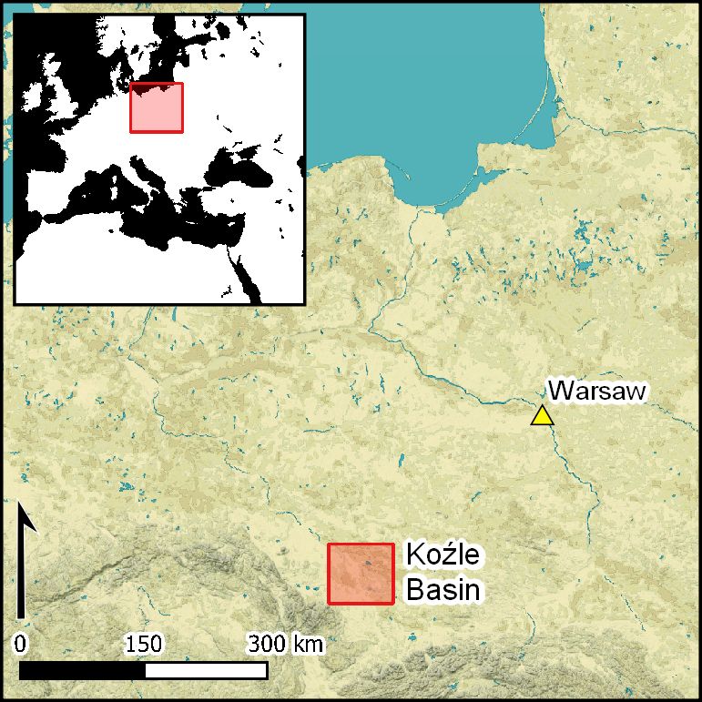
© The Author(s), 2021. Published by Cambridge University Press on behalf of Antiquity Publications Ltd

                                                                                                                                                                                                                                                                                                   The heritage of the Second World War: bombing in the Koźle Basin
423

                                                                                                               Figure 2. Bombardment areas (orthophotomaps: polska.e-mapa.net): P1) arable field; P2) new forest stand; P3) new forest stand (left), moor (centre), second-growth forest (right);
                                                                                                               P4) second-growth forest and meadow (prepared by Jan Maciej Waga).
Jan M. Waga & Maria Fajer
many forests and marshy wastelands around Ked̨ zierzyn-Koźle have preserved Poland’s largest
complex of open craters associated with intense Second World War bombing. These are pre-
dominantly large craters left by 500lb demolition bombs, and whose current diameters range
from 10–15m. They are often more than 2m deep. Smaller, 5–10m-diameter craters were left
by 250lb bombs (the size ranges of these two forms, however, may partially overlap). The craters
are visible in lidar-based digital elevation models (DEMs) (Figures 3–4). We identified 5238
well-preserved large bomb craters and 151 smaller ones in the vicinity of the former synthetic
fuel plants at Ked̨ zierzyn and Blachownia, and 484 large craters and 147 smaller ones near
Zdzieszowice. There are also many features that are less well defined in the DEMs.
We carried out detailed analysis of a zone with large clusters of craters near the western
perimeter of the former IG Farbenindustrie AG Werke Heydebreck plant (Figure 3).
Here, the density of clustered craters ranges from approximately 12–28 per hectare. The
site selected for the study is representative of the area of Ked̨ zierzyn and Blachownia in
terms of its soil and water conditions. It is situated within the Vistulian terrace, which com-
prises sands interbedded with silt, with organic deposits accumulated in depressions. Three
individual study areas were delineated within the detailed study zone: marshy area ‘a’, area ‘b’
with groundwater present at shallow depths, and area ‘c’ with groundwater present at greater
depths; the latter are covered by aeolian sands (Figure 4). The first groundwater level in these
three areas, which is present at depths ranging from 0–3m, is subject to seasonal fluctuations.
These areas are drained by drainage ditches. Area ‘d’ is located near the heavily bombed
freight railway station, immediately adjacent to the edge of the plant, and therefore includes
the largest cluster of craters. Some of these have been transformed into rectangular pits into
which sappers deposited unexploded ordnance found close to the plant after the air raids,
while some were backfilled after the war (Figure 4).
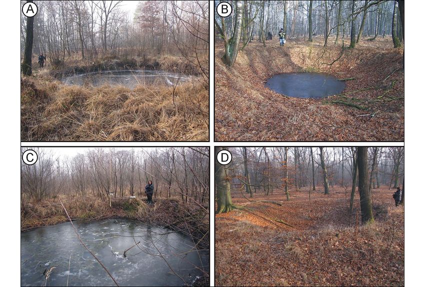
The craters with the largest diameters—usually over 12m—are present in area ‘a’.
The largest has a diameter of 15m (a1 on Figure 4) and is situated in the central part of a
hollow ‘valley’, in which organic deposits reach a thickness of 1m. Within this ‘valley’, the
craters have turned into small pools of water up to 1m deep (Figure 5A). Lidar scanning
has identified small peaks in the centres of many craters within the marsh (area ‘a’) and its
immediate vicinity. In area ‘b’, crater diameters range from 10–12m (Figure 4), and the
degree to which they have been filled with deposits and water is much lower than in area
‘a’. These craters are also deeper and the ridges around them are more pronounced (Figures
5B–C). The smallest changes—both primary (occurring just after the explosion) and second-
ary (taking place in the following years)—were observed in area ‘c’, within craters situated at
higher levels where groundwater can be found at greater depths. Here, the craters have dia-
meters of around 5–10m (left by 250lb bombs) and 10–12m (left by 500lb bombs), and
are of considerable depth. There is one spot where as many as three bombs hit, but there
are numerous twin craters where two bombs fell (see Figure 4: c2).
The arrangement of some craters may indicate the approximate azimuths of the air raids
carried out against IG Farbenindustrie Werke Heydebreck (Figure 3). These were 39°, 53°,
75°, 78°, 82°, 88°, 147° and 149°. Some of these directions are confirmed by the aerial
photographs taken during the operations in question (Figure 6), as well as daily reports
from the missions of the Fifteenth Air Force (https://15thaf.org/). To the south-west of
the IG Farben plant was located a flak (FlugabwehrKanone) anti-aircraft battery (Figure 7).
© The Author(s), 2021. Published by Cambridge University Press on behalf of Antiquity Publications Ltd
424The heritage of the Second World War: bombing in the Koźle Basin
Figure 3. Study area: 1) bomb craters; 2) detailed study area; 3) area shown in the orthophotomap; 4) P1, arable field;
P2–4, properly managed forest land; 5) area of detailed studies; 6) bombing directions; 7) main railway line (figure
prepared by Jan Maciej Waga, digital elevation model available from polska.e-mapa.net).
Nine craters were found approximately 270m to the north-west of the battery and 16 craters
1km to the south. In the south, the craters’ sizes and numbers suggest the use of 250lb
bombs. Here, the bombs fell on a dune and on marshy depressions, leaving craters with vari-
ous diameters. Given that flak batteries were not included as targets in similar large-scale air
raids, the significance of the spatial relationship between these three sets of craters is unclear.
Discussion
Of the numerous craters preserved around the Ked̨ zierzyn area, large 500lb bomb craters
dominate, with fewer craters left by 250lb bombs. We found a bimodal distribution of crater
© The Author(s), 2021. Published by Cambridge University Press on behalf of Antiquity Publications Ltd
425© The Author(s), 2021. Published by Cambridge University Press on behalf of Antiquity Publications Ltd
Jan M. Waga & Maria Fajer
426
Figure 4. Detailed study area: A: a–d) areas of detailed studies; a1–c1) location of the studied craters; their morphological profiles are below; c2) dune fragment with a triple crater;
e) marsh; f) surface of the Vistulian terrace; g) dune; B) chart of the diameters of craters in the studied area (figure prepared by Jan Maciej Waga, digital elevation model available
from polska.e-mapa.net).© The Author(s), 2021. Published by Cambridge University Press on behalf of Antiquity Publications Ltd
The heritage of the Second World War: bombing in the Koźle Basin
427
Figure 5. Craters: A) within the marsh; B) in the upper part of terrace; C) in the lower part of terrace; D) on the dune (photographs A, C & D by Jan Maciej Waga, B by Maria
Fajer).Jan M. Waga & Maria Fajer
Figure 6. B-24 bomber over the IG Farben plant, with part of the detailed study area visible below (source: National
Archives and Records Administration, https://catalog.archives.gov/id/193769549).
diameters (Figure 4A), reflecting the use of bombs of two weight categories. In the diameter
range 9–11m, the impacts of explosions overlap (Figure 4B). Passmore et al. (2018) present
charts that show correlations between crater sizes, bomb weights, fuse types and soil types.
The sizes of the craters found in the Koźle Basin fit well into Passmore et al.’s (2018) para-
meters. In heavily waterlogged and marshy areas, however, crater diameters exceed those
shown on the charts, as the wet soil on which the bombs fell lacked cohesion. There are
also central peaks present within these bomb craters. Such landforms were described
elsewhere (e.g. Trusheim 1940) at the outset of the Second World War. Central peak struc-
tures that are similar in shape, although much larger, can also be observed in meteorite impact
craters on Earth and other celestial bodies, and are considered to be the result of a complex
process that occurs as rock layers of the substrate react to the impact (Baker et al. 2016).
Laboratory tests have established that the formation of central peak structures requires a
considerable impact force directed at a steep angle (70–90°) relative to the ground surface.
It has also been found that such landforms are larger and better developed when fine-grained
material is involved (Katsuragi 2016).
The craters in the vicinity of Ked̨ zierzyn were created by explosions, and two main stages
can be distinguished in their formation process. The first stage involves the bomb entering the
© The Author(s), 2021. Published by Cambridge University Press on behalf of Antiquity Publications Ltd
428The heritage of the Second World War: bombing in the Koźle Basin
Figure 7. Flak battery near Dziergowice: 1) location; 2) bombardment area; 3) bombardment direction (figure
prepared by Jan Maciej Waga, digital elevation model available from polska.e-mapa.net).
ground and detonating, with a limited quantity of soil being thrown into the air and the
remaining soil being displaced sideways and downwards, where it was compressed. In water-
rich soil conditions, immediately after the shockwave has faded, liquefied floating earth
moves into the vacated space within the crater, driven by the sudden drop in pressure at
the explosion site and the forces of cohesion and gravity. Soil particles converge concentrically
in the centre of the crater, forming a convexity. This process can be compared to the behav-
iour of the hydrocode model presented by Pierazzo and Collins (2004), or the actual fluidised
medium in Gault and Greeley’s experiment (1978). The central peak comprises slightly
heavier material, while a mineral-organic suspension with a lower specific gravity accumulates
around it. Those soil particles that are thrown almost vertically upwards fall on the crater’s
surface, while the rest are scattered around the bomb impact site. The second phase involves
slower processes, in which material from crater edges and slopes slumps onto its base, which
had already been covered with sediments. The resulting landform, although deep, resembles a
plate rather than a crater on the surface. Such forms are present, inter alia, in area ‘a’.
© The Author(s), 2021. Published by Cambridge University Press on behalf of Antiquity Publications Ltd
429Jan M. Waga & Maria Fajer
Where a bomb penetrates a thicker layer of dry earth and the base of the crater reaches
below the groundwater table, an outflow of floating earth from the lower layers surrounding
the crater could occur. A higher ridge than in the case described above then forms at the edge
of the crater. These forms resemble shallow pans, and can often include central peaks. Such
landforms can be found in area ‘b’. Dynamic secondary processes take place on the slopes of
explosion craters situated in waterlogged areas and in those areas where groundwater can be
found at shallow depths. These include mudflows, rill erosion, scouring and subsequent
bioturbations, such as animal trampling of the crater edges and perforation of their slopes
by rooting and burrowing. Craters located in areas with a deeper water table are smaller in
diameter, and filled to a lesser extent with sediment, as material from their slopes is trans-
ported more slowly towards the base. Their ‘poorer’ habitat (i.e. less biodiversity) generates
less biomass. Landforms of this type can be found in area ‘c’.
The bomb craters in the vicinity of Ked̨ zierzyn-Koźle are relics that document important
historical events, and that constitute a link between the area and the battlefields of Europe
and beyond. In Western Europe, bomb craters are often protected in multiple ways (cf. Pass-
more & Harrison 2008; Capps-Tunwell et al. 2016; de Matos-Machado et al. 2019), but this
is not the case in Poland. It has taken only a short time for the bomb craters of the Koźle Basin
to become new elements of a considerably transformed forest and wetland ecosystem
(cf. Hupy & Schaetzl 2006; Hupy & Koehler 2012; Vad et al. 2017). They now represent
places where many amphibian, reptile, insect, bird and ungulate species reside, seek shelter or
breed. The craters also provide habitats for numerous plant species. The many water bodies
and marshes that formed in the bomb craters contribute to the diversification and enrichment
of local ecosystems, where sandy soils dominate. Here, we have a record of environmental
changes that have occurred over the past 75 years. This situation favours a model of comple-
mentary protection, recognising both the cultural and natural values of these craters, which
are relatively well preserved in the local forested areas (cf. Passmore & Capps-Tunwell 2020).
Bomb craters still hide dangerous reminders of the Second World War (Clermont et al.
2019; Kruse et al. 2019), and any hasty attempt to develop these areas without proper hazard
neutralisation may prove costly. Moreover, the morphology of forest and open areas should
not be altered without strong justification. Since the 1970s, cultivation methods that degrade
both the landscape and forest soils have been used in the state-owned forests of Upper Silesia.
Humus layers are bulldozed together with rootstocks and pushed into long heaps, although
there are less invasive ways of preparing landscapes for the planting of trees. Apart from the
degradation of the natural environment, traces of older human activities, such as charcoal-
making sites, settlements and military installations are also being destroyed (Figure 8).
Such pursuit of short-term goals often eclipses respect for historical value (Zalewska 2018).
Conclusions
The crater-strewn landscape that was formed in 1944 during heavy bombing around
Ked̨ zierzyn-Koźle is a phenomenon of European significance. These remnants of the conflict
attest to the tremendous effort expended by both sides during the war, and reflect the
enormous costs of warfare. Post-war practice has shown that areas with bomb craters can
be effectively utilised in forested areas (Figure 2) by introducing new crops in a manner
© The Author(s), 2021. Published by Cambridge University Press on behalf of Antiquity Publications Ltd
430The heritage of the Second World War: bombing in the Koźle Basin
Figure 8. The area around the former foresters’ lodge in Dąbrowa (the landscape is transformed as a result of improper
forest management): a) site of the former camp for Belgian and French prisoners of war; b) anti-aircraft battery
earthworks; c) well-preserved bomb craters; d) partly backfilled craters; e) heaps of soil and rootstocks (figure prepared
by Jan Maciej Waga, digital elevation model available from polska.e-mapa.net).
that does not compromise these landforms. Both dry craters and those containing water are
important ecological niches. This is particularly significant in the case of species that have
been displaced from the vast, adjacent areas now dedicated to agriculture. The opposite prac-
tice, however, is evidenced in forests near the former foresters’ lodge in Dab̨ rowa—just 2km
to the east of our detailed study area (Figure 8). There, the landscape has been heavily remod-
elled by bulldozing of the upper layers of soil and partial levelling of existing craters. The dif-
ference in the appearance of the preserved and transformed landforms is clear. In historical
education regarding Second World War battles, the images of vast battlefields with surfaces
marred by explosions are the most evocative for the general public (Ryan 2007). In order to
preserve the memory of those events, selected sets (at least) of such forms should be studied,
© The Author(s), 2021. Published by Cambridge University Press on behalf of Antiquity Publications Ltd
431Jan M. Waga & Maria Fajer
described and protected. In the case of Ked̨ zierzyn-Koźle, such remnants of war should be
safeguarded in a manner that recognises the complementary significance of both their
cultural/historical and natural/ecological values.
Acknowledgements
We would like to thank the two anonymous reviewers for their useful suggestions that greatly
improved the manuscript.
Funding statement
Open-access funding was provided by the Institute of Earth Sciences, University of Silesia in
Katowice.
References
Asch, A., H.R. Graff & T.A. Ramey. 1991. and Spatial Information Sciences XLII-2/W16:
The story of the Four Hundred and Fifty-fifth 67–74.
Bombardment Group (H) WW II: flight of the https://doi.org/10.5194/isprs-archives-XLII-2-
Vulgar Vultures. Appleton (WI): Graphic W16-67-2019
Communications Center. Craven, W.F. & J.L. Cate (ed.). 1983. The army air
Baker, D.M.H., J.W. Head, G.S. Collins & forces in World War II, volume 3. Europe: argument
R.W.K. Potter. 2016. The formation of to VE Day January 1944 to May 1945.
peak-ring basins: working hypotheses and path Washington, D.C.: Office of Air Force History.
forward in using observations to constrain models Ehlers Jr, R.S. 2009. Targeting the Third Reich: air
of impact-basin formation. Icarus 273: 146–63. intelligence and the Allied bombing campaigns.
https://doi.org/10.1016/j.icarus.2015.11.033 Lawrence: University Press of Kansas.
Brenner, S., S. Zambanini & R. Sablatnig. 2018. Fifteenth Air Force. 1944. Operations reports.
Detection of bomb craters in WWII aerial Unpublished documents for the period 4th July to
images. Proceedings of the OAGM Workshop 2018: the 26th December 1944. Available at:
94–97. https://15thaf.org/ (accessed 19 January 2021).
Capps-Tunwell, D., D.G. Passmore & Gault, D.E. & R. Greeley. 1978. Exploratory
S. Harrison. 2016. Second World War bomb experiments of impact craters formed in
craters and the archaeology of Allied air attacks in viscous-liquid targets: analogs for Martian
the forests of the Normandie-Maine National rampart craters? Icarus 34: 486–95.
Park, NW. Journal of Field Archaeology 41: 312–30. https://doi.org/10.1016/0019-1035(78)90040-4
https://doi.org/10.1080/00934690.2016.1184930 Gheyle, W., B. Stichelbaut, T. Saey, N. Note,
– 2018. A witness in the landscape: the bombing of H. van den Berghe, V. van Eetvelde, M. van
the Forêt domaniale des Andaines and the Meirvenne & J. Bourgeois. 2018. Scratching
Normandy campaign, NW France, 1944. War in the surface of war: airborne laser scans of the
History 25: 69–102. Great War conflict landscape in Flanders
https://doi.org:10.1177/0968344516650228 (Belgium). Applied Geography 90: 55–68.
Carter, K.C. & R. Mueller. 1991. U.S. Army air https://doi.org/10.1016/j.apgeog.2017.11.011
forces in World War II: combat chronology 1941– Haduch, E. n.d. Niemieckie zakłady paliwowe
1945. Washington, D.C.: Center for Air Force w rejencji opolskiej. Ked̨ zierzyn-Koźle.
History. https://doi.org/10.21236/ADA529766 Available at:
Clermont, D., C. Kruse, F. Rottensteiner & http://www.blechhammer1944.pl/artykuly/34/
C. Heipke. 2019. Supervised detection of bomb Niemieckie-zaklady-paliwowe-w-rejencji-
craters in historical aerial images using opolskiej (accessed 19 January 2021).
convolutional neural networks. The International Hesse, R. 2010. LiDAR-derived local relief models
Archives of the Photogrammetry, Remote Sensing (LRM): a new tool for archaeological prospection.
© The Author(s), 2021. Published by Cambridge University Press on behalf of Antiquity Publications Ltd
432The heritage of the Second World War: bombing in the Koźle Basin
Archaeological Prospection 17: 67–72. Eetvelde & M. van Meirvenne. 2019.
https://doi.org/10.1002/arp.374 Evaluation of fluxgate magnetometry and
Holland, J. 2018. Big Week: the biggest air battle of electromagnetic induction surveys for subsurface
World War II. New York: Atlantic Monthly. characterization of archaeological features in
Hupy, J.P. & T. Koehler. 2012. Modern warfare as World War 1 battlefields. Geoarchaeology 34:
a significant form of zoogeomorphic disturbance 136–48. https://doi.org/10.1002/gea.21700
upon the landscape. Geomorphology 157–58: Passmore, D.G. & S. Harrison. 2008. Landscapes
169–82. of the Battle of the Bulge: WW2 field
https://doi.org/10.1016/j.geomorph.2011.05.024 fortifications in the Ardennes Forests of Belgium.
Hupy, J.P. & R.J. Schaetzl. 2006. Introducing Journal of Conflict Archaeology 4: 87–107.
‘bombturbation’, a singular type of soil disturbance https://doi.org/10.1163/157407808X382773
and mixing. Soil Science 171: 823–36. Passmore, D.G. & D. Capps-Tunwell. 2020.
https://doi.org/10.1097/01.ss.0000228053. Conflict archaeology of tactical air power: the
08087.19 Forêt Domaniale de la Londe-Rouvray and the
Katsuragi, H. 2016. Physics of soft impact and Normandy campaign of 1944. International
cratering (Lecture Notes in Physics Series 910). Journal of Historical Archaeology 24: 674–706.
Tokyo: Springer. https://doi.org/10.1007/s10761-019-00536-5
https://doi.org/10.1007/978-4-431-55648-0 Passmore, D.G., S. Harrison & D. Capps-
KobiaŁKA, D. 2017. Airborne laser scanning and Tunwell. 2014. Second World War conflict
20th century military heritage in the woodlands. archaeology in the forests of North-west Europe.
Analecta Archaeologica Ressoviensia 12: 247–69. Antiquity 88: 1275–90.
https://doi.org/10.15584/anarres.2017.12.14 https://doi.org/10.1017/S0003598X00115455
– 2018. Being in the woodlands: archaeological Passmore, D.G., D. Capps-Tunwell &
sensibility and landscapes as naturecultures. S. Harrison. 2018. Revisiting the US military
Polish Journal in Landscape Studies 1: 43–53. ‘Levels of War’ model as a conceptual tool in
Konieczny, A. 1998. Sla ́ ̨sk a wojna powietrzna lat conflict archaeology: a case study of WW2
1940–1944 (Acta Universitatis Wratislaviensis landscapes in Normandy, France, in N. Moreira,
1983). Wrocław: Wydawnictwo UW. M. Derderian & A. Bissonnette (ed.) Fields of
Kruse, C., F. Rottensteiner & C. Heipke. 2019. conflict, conference proceedings 1: 18–35. Ledyard
Marked point processes for the automatic (CT): Mashantucket Pequot Museum &
detection of bomb craters in aerial wartime Research Center.
images. The International Archives of the Pierazzo, E. & G. Collins. 2004. A brief
Photogrammetry, Remote Sensing and Spatial introduction to hydrocode modeling of impact
Information Sciences XLII-2/W13: 51–60. cratering, in H. Dypvik, M. Burchell & P. Claeys
https://doi.org/10.5194/isprs-archives-XLII-2- (ed.) Cratering in marine environments and on ice:
W13-51-2019 323–40. Berlin & New York: Springer.
Levine, A.J. 1992. The strategic bombing of Germany, https://doi.org/10.1007/978-3-662-06423-8_16
1940–1945. Westport (CT) & London: Praeger. Ryan, C. (ed.). 2007. Battlefield tourism: history, place
Mahoney, K.A. 2013. Fifteenth Air Force against the and interpretation. Amsterdam: Elsevier.
Axis: combat missions over Europe during World van der Schriek, M. 2019. Archaeological research
War II. Lanham (MD) & Toronto: Scarecrow. and heritage management on Second World War
de Matos-Machado, R., J.-P. Toumazet, conflict sites in the Netherlands, in T.L. Sutherland,
J.-C. Bergès, J.-P. Amat, G. Arnaud-Fassetta, D. Shiels, G. Hughes & S.H. Sutherland (ed.)
F. Bétard, C. Bilodeau, J.P. Hupy & Conference proceedings: fields of conflict, 2016.
S. Jacquemot. 2019. War landform mapping Dublin: Trinity College. Available at:
and classification on the Verdun battlefield http://fieldsofconflict.com/c_paper.php?
(France) using airborne LiDAR and multivariate id=22&act=full (accessed 19 January 2021).
analysis. Earth Surface Processes and Landforms 44: van der Schriek, M. & W. Beex. 2017. The
1430–48. https://doi.org/10.1002/esp.4586 application of LiDAR-based DEMs on WWII
Note, N., T. Saey, W. Gheyle, B. Stichelbaut, conflict sites in the Netherlands. Journal of
H. van den Berghe, J. Bourgeois, V. van Conflict Archaeology 12: 94–114.
© The Author(s), 2021. Published by Cambridge University Press on behalf of Antiquity Publications Ltd
433Jan M. Waga & Maria Fajer
https://doi.org/10.1080/15740773.2017. aquatic conservation. Biological Conservation 209:
1440960 253–62.
Trusheim, F. 1940. Fliegerbomben und Geologie: https://doi.org/10.1016/j.biocon.2017.02.025
kleine geologische Beobachtungen an Zalewska, A.I. 2018. Ewidentne relikty wojen XX
Fliegerbomben-Einschlagen. Natur und Volk 70: wieku w ewidencji zabytków. Oddziaływanie
317–21. wyników badań z zakresu archeologii
Vad, C.F. et al. 2017. Wartime scars or reservoirs of współczesności w przestrzeniach konserwatorskiej
biodiversity? The value of bomb crater ponds in i publicznej. Kurier Konserwatorski 15: 42–53.
© The Author(s), 2021. Published by Cambridge University Press on behalf of Antiquity Publications Ltd
434You can also read