The IGN-E Case: Integrating Through a Hidden Ontology
←
→
Page content transcription
If your browser does not render page correctly, please read the page content below
The IGN-E Case: Integrating Through a Hidden
Ontology

A Gómez-Pérez 1, JA Ramos 1, A Rodríguez-Pascual ²,
LM Vilches-Blázquez ²
1
     Ontology Engineering Group – UPM, Spain
     email: {asun, jarg}@fi.upm .es
²    National Geographic Institute of Spain (IGN-E), Spain
     email: {afrodriguez, lmvilches}@fomento.es

Abstract

National Geographic Institute of Spain (IGN-E) wanted to integrate its
main information sources for building a common vocabulary reference and
thus to manage the huge amount of information it held. The main problem
of this integration is the great heterogeneity of data sources. The Ontology
Engineering Group (OEG) is working with IGN-E to attain this objective
in two phases: first, by creating automatically an ontology using the se-
mantics of catalogues sections, and second, by discovering mappings au-
tomatically that can relate ontology concepts to database instances. So,
these mappings are the instruments to break the syntactic, semantic and
granularity heterogeneity gap. We have developed software for building a
first ontology version and for discovering automatically mappings using
techniques that take into account all types of heterogeneity. The ontology
contains a set of extra-attributes which are identified in the building pro-
cess. The ontology, called PhenomenOntology, will be reviewed by do-
main experts of IGN-E. The automatic mapping discovery will be also
used for discovering new knowledge that will be added to the ontology.
For increasing the usability and giving independence to different parts, the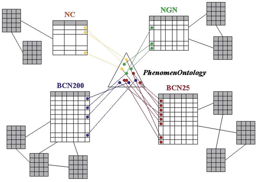
418   A. Gómez-Pérez et al.

processes of each phase will be designed automatically and as upgradeable
as possible.

Keywords: ontology creation, geographic information, feature cata-
logues, mapping discovery, ontology-database mapping, heterogeneity

1. Introduction

National Geographic Institute of Spain (IGN-E) wanted to integrate its in-
formation sources for building a common vocabulary reference and thus to
manage the huge amount of information it held. The main reason was to
offer a unified national vocabulary to different Geographical Information
(GI) producers, which have different interest, necessities and work scale
(national – regional – local).
   IGN-E has four main databases that correspond to different scales: Con-
ciso Gazetteer (NC) (1:1,000,000), National Geographic Gazetteer (NGN)
(1:50,000), Numerical Cartographic Database (BCN200) (1:200,000) and
Numerical Cartographic Database (BCN25) (1:25,000). Each database has
a different constant table to store represented features and their attributes.
These databases are maintained separately and present great heterogeneity
in different issues as we will show below.
   The active collaboration between IGN-E and OEG (Ontology Engineer-
ing Group) of UPM (Universidad Politécnica de Madrid) aims to create an
integration framework for maintaining the current databases. This frame-
work will be designed and, in the future, added to databases, and it should
be built following the most automatic processes in order to solve as best as
possible the heterogeneity problems that may arise.
   This paper is organized as follows. Section 2 presents the history and
characteristics of the current catalogues involved in this integration work.
Section 3 describes the problems found and the approach proposed to solve
them. Section 4 focuses on heterogeneity types and levels. Section 5 cov-
ers the steps followed to integrate the different feature catalogues. Section
6 shows in detail the automatic ontology creation. Section 7 deals with the
automatic mapping discovery. Finally, section 8 provides some brief con-
clusions and discusses some future lines of work.
The IGN-E Case: Integrating Through a Hidden Ontology   419

2. Existing catalogues

The IGN-E has various databases and feature catalogues, but this work fo-
cuses on four main data sources: two Numerical Cartographic Database
(BCN25 and BCN200) and two gazetteers (Concise Gazetteer and Na-
tional Geographic Gazetteer).
   With regard to the two Numerical Cartographic Databases, we can point
out that they are considered as feature catalogues. This type of catalogue
presents the abstraction of reality, represented in one or more sets of geo-
graphic data, as a defined classification of phenomena. It defines the fea-
ture type, its operations, attributes, and associations represented in geo-
graphic data. This type of catalogue is indispensable to turning data into
usable information (ISO 19110). Next we provide some details of these
data sources.
   BCN25 was designed as a derived product from the National Topog-
raphic Map, which was created at a 1:25,000 scale (MTN25) in 1997,
whereas MTN was created at a 1:50,000 scale (MTN50) in 1870. This long
and hard project culminated at the end of the 1960s leaving behind great
many changes due mainly to the continuous evolution that affected carto-
graphic techniques during those years. From 1975 onwards, the updating
of maps was carried out simultaneously with the production of a new se-
ries of maps at a1:25,000 scale (MTN25) with the aim of complementing
MTN50 with some areas of special interest. However, in the 1980s these
new series became a national coverage project. This Numerical Carto-
graphic Database (BCN25) was built to obtain the 1:25,000 cartographic
information that complies with the required data specifications exploited
inside Geographic Information Systems (GIS) environments. Therefore,
BCN25 contains essentially the same information than MTN25, though it
has some additional geometric and topological properties, following a spe-
cific database oriented model and feature catalogue (Rodriguez 2005). The
figure below shows a small part of the BCN25 feature catalogue.
420   A. Gómez-Pérez et al.

Fig 1. Source: BCN25

  On the other hand, the first version of the Numerical Cartographic Data-
base (BCN200) at a1:200,000 scale was started in 1985. This work was
developed through analogical map digitalisation of provincial maps at this
scale (Sevilla 2006). Below, a part of the BCN200 feature catalogue is
shown as an example of the layout that the catalogue presents.
The IGN-E Case: Integrating Through a Hidden Ontology 421
Fig. 2. Source: BCN200
The information contained in the two Numerical Cartographic Data-
bases is structured in eight different topics (Administrative boundaries, Re-
lief, Hydrography, Vegetation, Buildings, Communications, Piping lines
and Toponymy). Each topic is coded with three pairs of digits: two for its
topic, two for its group (part of homogeneous information structured in
topics) and two for its subgroup (a stretch of geographic feature belongs to
a group). These numbers describe and classify different features regardless
of its location and spatial dimension. The following text box shows an ex-
ample of how this information has been structured.
Topic 03: Hydrography
Group: 01 constant watercourse
Subgroup: 01 Watercourse symbolized with one line
Figure 1 and 2 have other codes to symbolize graphical characteristics,
which are associated to Computer Aided Design (CAD) Systems. These
digits belong to the following attributes: level (LV), colour (COL), weight
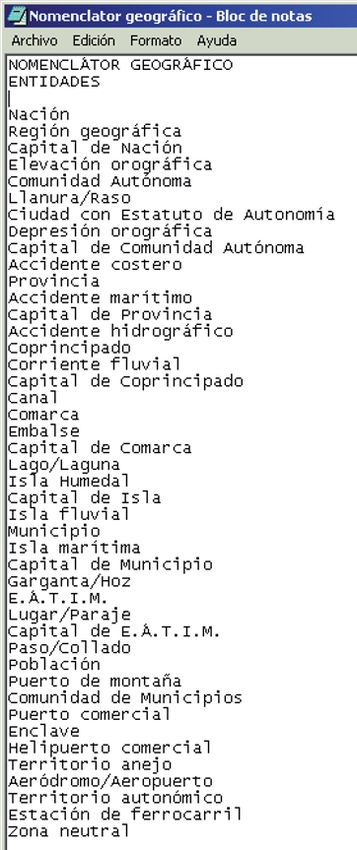
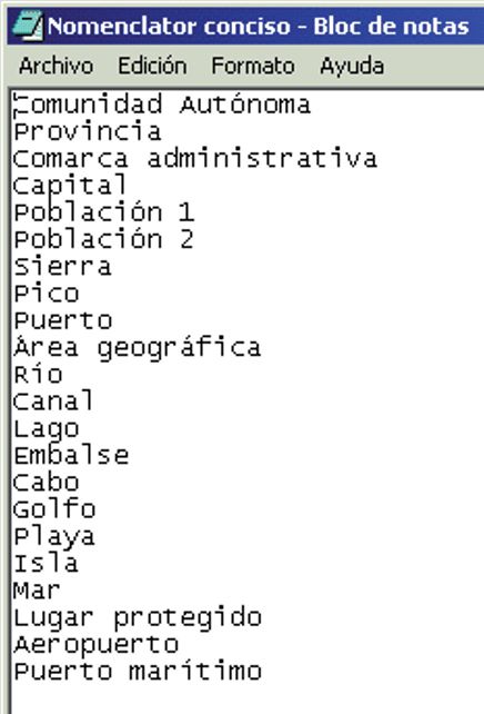
(PS) and style (LC).422 A. Gómez-Pérez et al. The BCN25 feature catalogue has a peculiarity. This peculiarity appears as attributes named DGN_Type (“Tipo_dgn”), Entity (“Entidad”) or Group (“Grupo”), which represent an alternative way for structuring these geo- graphical features. These attributes are shown in figure 1 and are subdi- vided into different categories. An odd case is the classification proposed by the “Group” attribute, since it represents a brief, but similar classifica- tion within this catalogue. It is subdivided into five topics (No specified, Roads, Hydrography, Piping lines and Administrative). As regards gazetteers, a widespread definition of this concept comes from (ISO 19112). This standard defines a gazetteer as a directory of in- stances of a class or classes of features that contain some information re- garding position. Next, some of the main characteristics of the IGN-E gaz- etteers are described. The National Geographic Gazetteer (see figure 3), also called Georefer- enced DataBase or NOMGEO, has 460,000 entries, which belong to dif- ferent features in Spanish, Galician, Catalan, Basque and Aranes (official languages of Spain). This gazetteer has 14 items with Universal Transverse Mercator (UTM) and geographic coordinates. Moreover, the gazetteer is the information source of the Web Service of the Spanish Spatial Data In- frastructure (IDEE)1. The Conciso Gazetteer (see Fig. 3) is a basic corpus of standardized toponyms created by the Spanish Geographical Names Commission. The first version has 3667 toponyms. This gazetteer agrees with the United Na- tions Conferences Recommendations on Geographic Names Normaliza- tion. Furthermore, the gazetteer has 17 items, of which some are manda- tory: Name, Name Language, Group, Feature Type, Province, Autonomous Region, Latitude, Longitude, Map and Name Source; and others, optional: Variant, Variant Language, Before, Before Language, Municipality, Variant Source and Observations. These items are in accor- dance with the Spanish Gazetteer Model2. The Conciso Gazetteer has been created by the Spanish Geographical Names Commission. For further de- tails, refer to (Nomenclátor Geográfico Conciso 2006). Regarding previous data sources, there is, in some cases, a mix between geographical and cartographic concepts. On the one hand, in IGN-E gazet- teers, only geographic concepts such as Reservoir (“Embalse”), Province (“Provincia”) Plain (“Llanura”), etc. appear, whereas in the BCN feature catalogues we can only find concepts specific to the GI domain (as prov- ince, river or dam) and some of their geometrical characteristics (as outline, 1 http://www.idee.es 2 http://www.idee.es/resources/recomendacionesCSG/MNEv1_2.pdf
The IGN-E Case: Integrating Through a Hidden Ontology      423

axis, symbolized by one line and so on). This peculiarity will not have any
influence on the development of our work.

Fig. 3. Feature Types of IGN-E Gazetteers Conciso Gazetteer (left) National Geo-
graphic (right)

3. Problems and the proposed approach

From a general viewpoint, GI is increasingly captured, managed and up-
dated with variable levels of granularity, quality and structure by different
cartographic agencies. In practice, this approach causes the building up of
multiple sets of spatial databases with a great heterogeneity of feature cata-
logues and data models. That means a coexistence of a great variety of
sources with different information, structure and semantics without a
general harmonization framework. On the other hand, this heterogeneity
424   A. Gómez-Pérez et al.

combined with the sharing needs of miscellaneous users and information
overlaps from different sources, causes several and important problems
when linking similar features, to search, retrieve and exploit GI data
(Vilches et al. 2007a).
   From a narrow viewpoint, the most important concept for GI is the fea-
ture since the Open GeoSpatial Consortium (OGC 2003) has declared that
a geographic feature is the starting point for modelling geospatial informa-
tion. For that reason, the basic unit of GI within most models is the “fea-
ture”, an abstraction of a real world phenomenon associated with a loca-
tion relative to the Earth, about which data are collected, maintained and
disseminated (ISO 19110). Features can include representations of a wide
range of phenomena that can be located in time and space such as build-
ings, towns and villages or a geometric network, geo-referenced image,
pixel or thematic layer. This means that, traditionally, a feature encapsu-
lates in one entity all that a given domain considers about a single geo-
graphic phenomenon (Greenwood et al. 2003). From this point of view, we
can observe that the heterogeneity associated to the feature term grows
more because of the interests and necessities of different GI producers.
   From an ontological perspective, no ontology has compiled the charac-
teristics and peculiarities of Spain’s geographic features. Up to now, there
is only an hydrographical feature ontology of these characteristics, called
hydrOntology (Vilches et al. 2007b). On the other hand, the use of stan-
dardized vocabularies, such as CORINE Land Cover3, EuroGlobalMap4
or EuroRegionalMap5 involves an oversimplification of the existing com-
plex reality because each GI producer (both national and local) has differ-
ent feature catalogues (following their self-interests), which provokes that
the overlaps between features are, quite often, not totally evident.
   Taking into account these reasons, we decided to design an integration
framework without having to reuse the information technology (standards,
ontologies, feature catalogues, etc.) available. Fig. 4 shows the approach
proposed for this integration, which implies using an ontology of features
while keeping the current databases.

3 http://dataservice.eea.europa.eu/dataservice/metadetails.asp?id=950
4 http://www.eurogeographics.org/eng/03_projects_EGM_overview.asp
5 http://www.eurogeographics.org/eng/03_projects_euroregionalmap.asp
The IGN-E Case: Integrating Through a Hidden Ontology   425

Fig. 4. Proposed approach

   As can be seen, an ontology (called PhenomenOntology) conceptualises
features, and their concepts will be mapped to their corresponding phe-
nomenon row in each database.
   For integrating GI by means of ontologies, some authors propose a
multi-ontology system (Stuckenschmidt et al. 1999) (Hakimpour et al.
2001) (Fonseca et al. 2002). In such approach each organization integrates
its information sources using a local ontology; other ontology integrates all
the organization ontologies of the system. According to this approach, our
integration framework will be an organization inside a multi-ontology sys-
tem.
   Following the classification of ontologies for the geographic world pro-
vided by (Fonseca et al. 2002), in our framework we will build a Phe-
nomenological Domain Ontology (PDO) that we will name PhenomenOn-
tology.

4. Heterogeneity

In the geographical information domain, any differences in data sources,
disciplines, tools and repositories can cause heterogeneity (Alonso et al.
426   A. Gómez-Pérez et al.

1994). Next, we describe the different approaches that tackle heterogeneity
problems.
   In (Bishr 1998), three different heterogeneity types (semantic, schematic
and syntactic) are distinguished. First, semantic heterogeneity is usually
the source of most of data sharing problems. This occurs because of the
variation of models of the different disciplines and necessities, though
geographical features are likely to share a common interest. Heterogeneity
is subdivided into cognitive heterogeneity and naming heterogeneity. Cog-
nitive heterogeneity is frequent when there is not a common base of defini-
tions for the common features of different catalogues or databases,
whereas naming heterogeneity is due to semantically alike features that
might be named differently. For instance, watercourse and river are two
names describing the same thing. On the other hand, in schematic hetero-
geneity the classification and hierarchical structure of the geographical fea-
ture could vary within or across disciplines. Finally, syntactic heterogene-
ity is divided in two types, one is related to the logical data model and its
underlying DBMS (DataBase Management System), e.g., relational and
object oriented, while the other is related to the representation of the spa-
tial objects in the database.
   Another approach to classify heterogeneity problems has been devel-
oped by (Hakimpour 2003). This proposal puts forwards other classifica-
tion, which presents similar aspects of heterogeneity to the previous one
• Heterogeneity in the conceptual modelling: A geographical feature can
  be represented in one system as an object class, and in other, as a
  relation.
• Heterogeneity in the spatial modelling: This feature type could be
  represented by polygons (or a segment of pixels) in one system, while
  being represented by lines in the second system.
• Structure or schema heterogeneity: In this heterogeneity type it is
  possible that different systems hold the same name for a same feature,
  but different attributes or formats. Therefore, the information of each
  system is different.
• Semantic heterogeneity: One system may adopt a viewpoint about a
  feature, while the other may adopt a different one. Moreover, it is usual
  to find different definitions of a same feature.
  In these classifications, big differences of granularity in a same domain
do not appear as a heterogeneity problem; however, heterogeneity prob-
lems are presented in our catalogues because the conceptual overlap is
complete, so the number of concepts that describe the geographical domain
The IGN-E Case: Integrating Through a Hidden Ontology   427

range from 22 to over 400. This gap represents other type of heterogeneity
which will be taken in account.
   For solving the different problems caused by heterogeneity we will have
to use mapping techniques. In our integrated system, mappings are the
components which relate heterogeneous elements. So, mappings have to
solve the heterogenity gap between ontology and catalogues.

5. From proposal to reality

We have carried out the integration task in two phases: first, the building
of PhenomenOntology, and then the mapping of the catalogues with Phe-
nomenOntology.
   To build the ontology, the members agreed to generate automatically an
ontology that could cover as best as possible different feature domains
(Administrative boundaries, Vegetations, Buildings, etc). For that, the do-
main experts decided to use the BCN25 catalogue, which is the most de-
tailed one, for extracting the information and then with that information
creating the ontology automatically. Once the ontology is created, the do-
main experts will have to review and modify it to cover all features pre-
sented in other catalogues.
   To build mappings, OEG is creating a framework which permits adding
new techniques for mapping discovery between our ontology and a data-
base table. The discovery has to be automatic and the resultant alignments
will be reviewed by domain experts. Here, we present how to include
within the mapping discovery the automatic recognition of new knowledge
for learning.
   The process above described is carried out in two phases and to enhance
usability such phases are designed as automatic sub-processes:1) For creat-
ing ontologies automatically, the configurable application, already built,
permits experts to generate ontologies quickly and to evaluate the most ap-
propriate taxonomic building criteria. 2) For mapping discovery, the auto-
matic feature will permit to enlarge the system with other catalogues in the
near future.
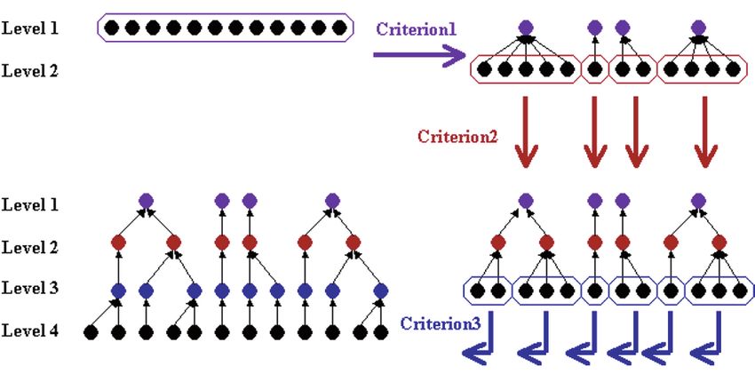
428   A. Gómez-Pérez et al.

6. Automatic ontology creation

6.1 Scales and coverage
As we have mentioned above, each of the IGN-E catalogues corresponds
to a different scale. Therefore, the number of features is inversely propor-
tional to the scale, because the detail permits distinguishing more special-
ized geographical features. Then, we use a 1:25,000 scale catalogue to
generate automatically an ontology using an ad hoc application. This ap-
plication extracts from instances of a feature catalogue the concepts of
PhenomenOntology.
   Theoretically, the list of the smaller scale catalogue includes all the fea-
tures of the larger scale, but this is not truth since a small number of fea-
tures do not appear in the list of the smallest scale features. Examples of
these features are: “cordillera” (mountain chain) or “península” (penin-
sula), these features cannot be drawn in a map following the smallest scale
and these names only appear in a 1:1,000,000 scale catalogues. These spe-
cial features or terms will be considered during the debugging phase car-
ried out by experts of the domain, though we pretend to identify these
terms in the mapping phase.

6.2 Criteria for taxonomy creation
The software developed for the automatic creation of an ontology permits
selecting the criteria for taxonomy creation and its order. These criteria are
based on the information contained in each row of the BCN25 feature cata-
logue table. First, the column codigo (code) stores codified information
about a three-level taxonomy. Therefore, there are three separate criteria
from which to extract a superclass in the taxonomy creation process: the
first pair, the second pair, and the third pair of code digits. Then, the appli-
cation permits extracting a super class for each different value of the cho-
sen pair of digits. For increasing the versatility, the application permits se-
lecting one of these pairs of digits, making possible to extract the
taxonomy in different fashions: the first level of extraction attending the
first pair of digits, the second level of extraction attending the third pair; or
attending firstly the second pair and secondly the first pair; or any combi-
nation of one, two or three levels.
   Three levels can result insufficient for a taxonomy with more than eight
hundred leaves. So, we have added another criterion for creating automati-
cally a taxonomy level: common lexical parts. At the beginning of the fea-
tures, the application can identify common substrings of feature names and
The IGN-E Case: Integrating Through a Hidden Ontology   429

then create a common superclass of those concepts whose names begin
with an identified substring. See an example of these criteria: we start with
concepts “Autovía”, “Autopista 2 carriles”, “Autopista 3 carriles puente”
and “Autopista 3 carriles tunnel” that are siblings; when this criterion is
applied, it produces a superclass called “Autopista” (sibling of “Autovía”)
which has as subclasses “Autopista 2 carriles”, “Autopista 3 carriles
puente” and “Autopista 3 carriles túnel”. Applying this criterion twice, the
software produces a taxonomy that has “Autovía” and “Autopista” as sib-
lings; then “Autopista 2 carriles” and “Autopista 3 carriles” are siblings
and sons of “Autopista”; and “Autopista 3 carriles puente” and “Autopista
3 carriles túnel” are siblings and sons of “Autopista 3 carriles”.
   While testing the software, IGN-E and OEG noticed that the substring
criterion is not useful because there is lexical heterogeneity in phenome-
non names. Therefore, we created another substring criterion to solve the
heterogeneity problems mentioned above, and as a result the substrings
“Autovía”, “AUTOVIAS”, “Autovia.” and “autovía-” are the same when
we create a superclass.
   According to the atributes of the BCN25 feature catalogue table, we
created another criterion to extract superclasses (a new taxonomy level) for
different values of grupo (group) that represents a top level classification
of feature (as the first pair of code digits).
   There are a total of six criteria which can be ordered and combined as
we wish, while a same criterion can, sometimes, be included in the criteria
list. Fig. 5 shows a schematic example of three criteria.

Fig. 5. Example of taxonomic level creation
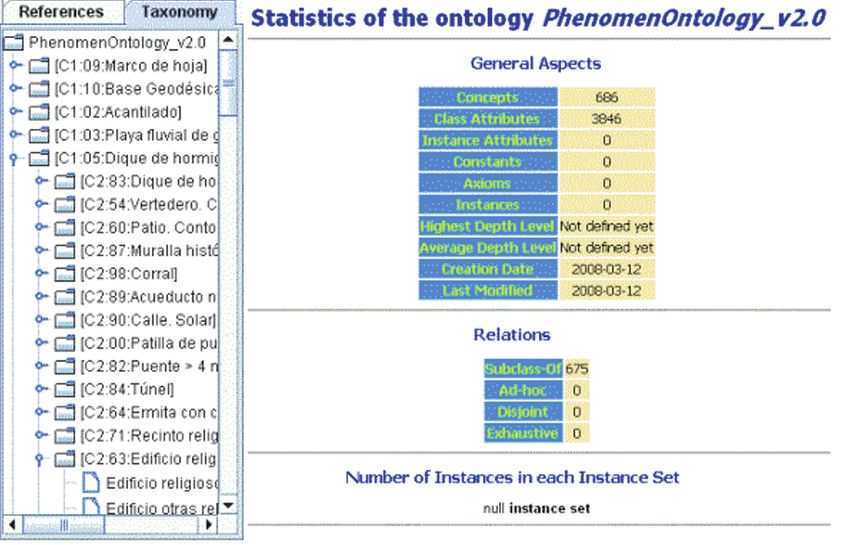
430   A. Gómez-Pérez et al.

6.3 Attributes by values
We can find other type of information in feature names that can be quite
interesting for ontology conceptualisation. Indeed, feature names in data-
bases contain the values of conceptual attributes (called data properties in
the description logics paradigm) that are not explicit in database models.
For example, the state of a railway, which can be “en uso” (in use), “en
construcción” (under construction), “abandonado” (abandoned) or “des-
mantelado” (dismantled). There is an opportunity for enrichment the con-
ceptualization attending to these attribute values held in labels. We can
upgrade the scanning values by inserting concept attributes with the values
found during the reviewing of the concepts.
   We had the opportunity of including within the ontology creation soft-
ware an analyser of feature names. To do that, the software uses a file con-
taining the attribute names and their values; the concepts of the ontology
created can have more attributes than databases columns, taking these ex-
tra-attributes the values appearing in the name. For example, the concept
“FFCC doble desmantelado” (double railway dismantled) will have two
extra-attributes: “número de vías” (number of tracks) with value “doble”
(double) and “estado” (state) with value “desmantelado” (dismantled). The
number of extra-attributes or their values is open for this application.

6.4 PhenomenOntology
IGN-E used the application developed for generating criteria combination
tests and chose an automatic generated ontology with three levels (two cri-
teria), 686 concepts and 3,846 attributes, as can view in Fig. 6. This ontol-
ogy is stored in the WebODE platform (Arpírez et al. 2003).
   This first version of the ontology is being refined by IGN-E experts us-
ing the WebODE Editor.
The IGN-E Case: Integrating Through a Hidden Ontology   431

Fig. 6. PhenomenOntology v2.0 and its statistics

7. Automatic mapping discovery

In the approach here presented there are elements that relate feature stored
in databases to concepts of PhenomenOntology. These elements are map-
pings.
   The sets of mappings are classified into intensional and extensional;
they are intensional when mappings relate elements of different set of in-
stances, and they are extensional, when mappings relate elements of dif-
ferent conceptualizations. In our case, mappings relate instances of a
model (rows of a table of a Relational Model) to concepts (elements of an
ontology conceptualisation). We have not found similar cases in the litera-
ture and only a definition of mapping covers this type of relations. This
definition is: “A mapping is a formal explicitation of a relation between
elements, or set of elements, of different conceptualizations and/or instan-
tiations.” (Gómez-Pérez et al. 2008).
   Automatic mapping discovery is a traditional work area in which many
algorithms and tools are developed; but due to our specific scenario, de-
scribed above, we need to create new tools and algorithms, studying the
existing reuse techniques (distance measures, matching terms, etc.).
432   A. Gómez-Pérez et al.

   We have identified several techniques to discover mappings following
the analysis of feature catalogue. Below we present different analyses to
review coverage of different heterogeneity types:
• Syntax analysis: String comparison. Before making string comparison, it
  would be necessary to regularize the string format (capitals, blank
  spaces, plurals, etc.). This kind of analysis solves, partially, semantic
  heterogeneity. Example: “autovia”, “Autovía.”
• Syntax analysis: Regular expression. The inclusion of names into other
  names might represent hiperonymy/hiponymy information. This kind of
  analysis solves, partially, granularity heterogeneity. Example: “autovía”,
  “Autovía en construcción”.
• Semantic analysis: Hiperonymy. If it is possible to access linguistics
  resources where looking for hiperonymy information between names or
  part of names. This kind of analysis solves, partially, granularity
  heterogeneity. Example: “muro”, “recinto amurallado”.
• Semantic analysis: Synonymy. If it is possible to access to linguistics
  resources to look for synonymy information between names, acronyms
  or abbreviations. This kind of analysis solves, partially, semantic
  heterogeneity. Example: “muro”, “pared exterior”.
• Semantic analysis: Root. The comparison of roots of lemmas can
  provide information about synonymy. This kind of analysis solves,
  partially, semantic heterogeneity. Example: “muro”, “muralla”.
• Semantic analysis: Definitions. IGN-E provides mapping discovery with
  a set of definitions about features. With these definitions we will
  discover new synonymy and hyponymy relations. This kind of analysis
  solves, partially, semantic and granularity heterogeneity. For instance:
  “muro”, “muralla: muro que rodea un recinto fortificado”.
• Code analysis. Codes are identifiers and we use this code information
  (see code description in section 2) to identify synonymy relations. This
  kind of analysis solves, partially, semantic heterogeneity. For instance:
  “064401 Vías de estación de FFCC. Vía de servicio” (BCN25), “064401
  FFCC.VIA_DE_SERVICIO” (BCN200).
• Structural analysis. As mentioned above, codes are composed of three
  pairs of digits with taxonomic information embedded. This taxonomic
  information can be used in catalogues with codes for scanning an
  ontology. This kind of analysis solves, partially, schematic
  heterogeneity. Example: “064204 FFCC en construcción en puente”
  (BCN25) implies 06 is transports, 42 is railways (a subclass of
  transport), and 04 is a subclass of railways.
The IGN-E Case: Integrating Through a Hidden Ontology    433

7.1 Knowledge discovery
To facilitate the review and depuration of the automatic creation of the on-
tology, during the mapping discovery phase we have studied how to iden-
tify new knowledge while discovering mappings. Therefore, in the near fu-
ture we will take in account two techniques:
• Code analysis. Codes are identifiers and we use code information (see
  code description in section 2) to identify synonymy relations between
  terms; then we reuse this semantics for mapping discovery. Example:
  “064301 FFCC abandonado o desmantelado” (BCN25), “064301
  FFCC_FUERA_DE_SERVICIO” (BCN200).
• Not identifying the relations with ontology concepts implies lacks of
  knowledge in the ontology added. Example: “068202 Radiofaro”
  (BCN200).

8. Conclusion and future work

Our application for finding lexical heterogeneity in feature names has
permitted IGN-E domain experts to evaluate its main data sources.
   The automatic creation of ontologies and the easy combination of crite-
ria have permitted us to have, very quickly, different first version ontolo-
gies for evaluation; thus expert time and efforts are saved. Other advan-
tages of the application are the identification of extra-attributes by values
in the feature names and the automatic storage in an ontology management
platform such as WebODE, which permits debugging the ontology by ex-
perts easily.
   The mapping discovery process is now being developed and we expect
to obtain the first results in a few months. The process is being conscien-
tiously developed with the aim of incorporating it to regional and interna-
tional databases. In this mapping discovery, the application has to solve the
heterogeneity problem in different levels so as to identify mappings auto-
matically. However, the results of all the automatic processes must be re-
viewed by domain experts to get the most successful results.
   As we mentioned above, the mapping discovery phase is not concluded
yet. Therefore, this work is our priority for the near future.
   Once the framework is finished, the collaboration partners will develop
new techniques to discover mappings, which will improve this efficiency
and will cover other type of relations
   When the final phase of the mapping discovery framework is finished
and the new techniques are added, then the integration system will be
434   A. Gómez-Pérez et al.

enlarged automatically with the incorporation of other catalogues (regional
and local scale), extending the integration to other GI producers.

Acknowledgements
This work has been partially supported by the National Project “GeoBud-
dies” (TSI2007-65677C02) and the bilateral collaboration UPM-IGN
2007-2008. We are also grateful to Rosario Plaza for her help in checking
and reviewing the grammar and spelling of the paper and improving clarity
and style.

References
Alonso G, Abbadi AE (1994) Cooperative modelling in applied geographic re-
    search. International Journal of Intelligent and Cooperative Information Sys-
    tems, 3(1): 83-102
Arpírez JC, Corcho O, Fernández-López M, Gómez-Pérez A (2003) WebODE in a
    nutshell. AI Magazine
Bishr Y (1998) Overcoming the semantic and other barriers to GIS interoperabil-
    ity. International Journal of Geographical Information Science, 12(4): 299–
    314
International Standard Organization (ISO) (2003) ISO 19112:2003 Geographic In-
    formation – Spatial referencing by geographic identifiers.
Fonseca FT, Egenhofer MJ, Davis CA, Câmara G (2002) Semantic Granularity in
    Ontology-Driven Geographic Information Systems. Annals of Mathematics
    and Artificial Intelligence. Volume: 36, 2002. Issue: 1-2, pp 121-151
Gómez-Pérez A, Ramos JA (2008) Semantic mappings: out of ontology world
    limits. Intl. Workshop on Ontology Alignment and Visualization. March 4-7,
    2008. Barcelona, Spain, pp 907-912
Greenwood J, Hart G (2003) Sharing Feature Based Geographic Information – A
    Data Model Perspective. 7th Int. Conference on GeoComputation. United
    Kingdom
Hakimpour F (2003) Using Ontologies to Resolve Semantic Heterogeneity for In-
    tegrating Spatial Database Schemata. Ph.D. thesis, Zurich University, Switzer-
    land
Hakimpour F, Timpf S (2001) Using Ontologies for Resolution of Semantic Het-
    erogeneity in GIS. 4th. AGILE Conference on Geographic Information Sci-
    ence, Brno, Czech Republic
ISO 19110 (2005) Geographic Information – Methodology for feature catalogu-
    ing.
ISO 19112 (2003) Geographic Information – Spatial referencing by geographic
    identifiers.
The IGN-E Case: Integrating Through a Hidden Ontology 435
Nomenclátor Geográfico Conciso de España (2006), versión 1.0. Presentación y
Especificaciones. Instituto Geográfico Nacional http://www.idee.es/ApliVisio/
Nomenclator/NGCE.pdf
OGC (2003) OpenGIS Reference Model. Version 0.1.2, OGC Inc. Wayland, MA,
USA
Rodríguez Pascual AF, García Asensio L (2005) A fully integrated information
system to manage cartographic and geographic data at a 1:25,000 scale. XXII
International Cartographic Conference. A Coruña, Spain. ISBN: 0-958-46093-0
Sevilla Sánchez C, Rodríguez Pascual AF, González Matesanz FJ, Blanco Ortega
LM, Vilches-Blázquez LM (2006) Un SIG corporativo en el IGN para la ges-
tión integrada, publicación y análisis de datos geográficos. In proceedings of
XII Congreso Nacional de Tecnologías de la Información Geográfica. Cama-
cho Olmedo, M.T.; Cañete Pérez, J.A.y Lara Valle, J.J. Ed. ISBN: 84-338-
3944-6 Depósito Legal: GR-1855-2006
Stuckenschmidt H, Visser U, Schuster G, Vögele T (1999) Ontologies for
geographic information integration. Proceedings of Workshop Intelligent
Methods in Environmental Protection: Special Aspects of Processing in Space
and Time, 13. International Symposium of Computer Science for Environ-
mental Protection, CSEP 1999, pp 81-107
Vilches-Blázquez LM, Rodríguez Pascual AF, Mezcua Rodríguez J, Bernabé Pov-
eda MA, Corcho O (2007a) An approach towards a harmonized framework for
hydrographic features domain. In Conference Proceedings of XXIII Interna-
tional Cartographic Conference. 4-10 August 2007, Moscow, Russia
Vilches Blázquez LM, Bernabé Poveda MA, Suárez Figueroa MC, Gómez-Pérez
A, Rodríguez Pascual A F (2007b) Towntology & hydrOntology: Relation-
ship between Urban and Hydrographic Features in the Geographic Informa-
tion Domain. In :Ontologies for Urban Development (Eds). Teller, J.;
Roussey, C.; Lee, J. Springer-Verlag, 2007. ISBN: 978-3-540-71975-5You can also read