The new National Atlas of Hungary - volume Natural Environment
←
→
Page content transcription
If your browser does not render page correctly, please read the page content below
The new National Atlas of Hungary – volume Natural
Environment

Károly Kocsis a, *, Zsombor Nemerkényi a, László Zentai b, Gábor Gercsák b
a Hungarian Academy of Sciences, Research Centre for Astronomy and Earth Sciences, Geographical Institute, Budapest, Hungary,
karcsikarcsi11@gmail.com, nemerkenyi.zsombor@csfk.mta.hu
b ELTE Eötvös Loránd University, Department of Cartography and Geoinformatics, Budapest, Hungary, lzentai@caesar.elte.hu,

gercsak@map.elte.hu
* Corresponding author

Abstract:
The new edition of the National Atlas of Hungary will be published in four volumes in Hungarian and in English to
present the dynamic spatial structure of nature, society and the economy not merely for Hungary, but wherever the
required data are available, for the Carpatho–Pannonian Area. In favour of keeping relations with the broader public and
meeting the requirements of the time, the National Atlas – in addition to its impressive printed form – will be published
also in digital version (e-MNA) in Hungarian and English. The traditional paper-based edition will cover the most
important topics in four volumes (The Hungarian State and its Place in the World; Natural Environment; Society;
Economy) and in representative quality. It will serve mainly awareness-raising and information provision rather than
academic research. The current volume of the new National Atlas of Hungary (MNA), which is presenting the Natural
Environment, is the outcome of wide ranging professional collaboration: 19 editors, 137 authors, 220 map authors, 17
cartographers, and several dozen professional and language proofreaders, translators have made their valuable
contributions to it.

Keywords: National atlas, Thematic maps, Hungary

                                                                     representative quality. It will serve mainly awareness-
1. Introduction
                                                                     raising and information provision rather than academic
In our days, most countries in the world have national               research. Naturally, we know that paper-based volumes,
atlases as far-reaching national symbols. Still based on             whose production takes a long time, may contain less up-
scientific research, since the late 1980s the more market-           to-date information at the time of their issue, therefore
oriented, more mass-consumable atlases have been issued              many present-day readers find them less attractive.
electronically as well as in hard copy. Traditional print            Nevertheless, future generations will see them as
atlases have definitely been pushed to the background                significant records of the period. In contrast, practically
compared to their electronic versions, which contain                 up-to-the-minute information and contact with the wider
almost unlimited amounts of multimedia elements.                     public will be ensured by the digital version (e-MNA)
Electronic atlases have become primary sources and tools             available at www.nationalatlas.hu.
of obtaining and analysing regional information.
In 2013 preparations for the new (conventional) edition of           2. Antecedents of the National Atlas of Hungary
the National Atlas of Hungary were started – under the               Hungarian geographers and cartographers have always
coordination of the Geographical Institute of the                    played a decisive role in developing knowledge about the
Academy’s Research Centre for Astronomy and Earth                    country and in forming an image of Hungary and the
Sciences, enjoying the support of the former president of            Hungarian nation. After World War I, numerous
the Hungarian Academy of Sciences. It is a unique novelty            geographic and cartographic works, including maps and
of our aims that the 2018 edition of the National Atlas of           series of maps, were published, mostly in French, English
Hungary wishes to present the dynamic spatial structure of           or German. These products presented the catastrophic
nature, society and the economy not merely for Hungary,              effects of the Treaty of Trianon (1920) on Hungary and
but wherever the required data are available, for the entire         sought to justify a complete or partial restoration of the
Carpathian Basin and its neighbourhood (the Carpatho–                territorial integrity of the country. However, the first
Pannonian Area), thus covering a territory of some half a            national atlas with a broad range of topics in the modern
million km² and 34 thousand settlements in twelve                    sense was only published in the second half of the 20th
countries.                                                           century, in 1967. This was followed by a second edition
The traditional paper-based edition will cover the most              with much richer content in 1989. The maps, with a few
important topics in four volumes (Part 1: The Hungarian              exceptions, concerned only the territory defined by the
State and its Place in the World; Part 2: Natural                    state boundaries of the Hungarian People's Republic. The
Environment; Part 3: Society; Part 4: Economy) and in                editing of this volume was coordinated by the

Proceedings of the International Cartographic Association, 2, 2019.
29th International Cartographic Conference (ICC 2019), 15–20 July 2019, Tokyo, Japan. This contribution underwent
single-blind peer review based on submitted abstracts. https://doi.org/10.5194/ica-proc-2-64-2019 | © Authors 2019. CC BY 4.0 License.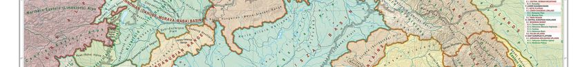
2 of 7

Geographical Research Institute of the Academy. The                  2.3. András RÓNAI (Ed.): Középeurópa Atlasz –
Institute, reacting to the rapidly changing social and               Atlas of Central Europe. Államtudományi Intézet –
economic conditions of Hungary's political transition,               Institute of Political Sciences, Budapest –
published five booklets of supplementary pages to the atlas          Balatonfüred. 1945
in 1994–1995. These maps were produced in a modern                   This work was edited by András Rónai, director of the
form and using digital technology.                                   Institute of Political Sciences, which is regarded as the
Despite two decades of fundamental economic and social               organizational predecessor of the present Geographical
changes, the Republic of Hungary has not yet felt it                 Institute, Research Centre for Astronomy and Earth
justified to publish a new national atlas. Meanwhile,                Sciences of the Hungarian Academy of Sciences. The atlas
national atlases have been published one after the other             was published in Hungarian and English and it met all the
throughout Europe, from Madrid to Moscow, Paris to                   requirements of a national atlas, with one exception: it did
Kiev, and Ljubljana to Warsaw. To meet public demand in              not show the territory of a country (Hungary) exclusively,
Hungary, Cartographia Co. published a smaller collection             but rather the area of Hungary, the Carpathian Basin and
of maps of Hungary in 1999. At the end of 2009 and in                its broader environment on 134 colour maps at a scale of
mid-2011, the Academy and the Geographical Research                  ca. 1:6.2 million on 334 pages. The English-language
Institute of the Academy each published a small atlas                version of the atlas (31.5 x 23 cm in size) contained 171
(Hungary in Maps) using their own financial resources.               maps on 367 pages. This masterpiece was originally
However, the two atlases are no substitutes for a modern             prepared for the talks on the peace treaty after World War
(printed and digital) Hungarian national atlas.                      II, but later it was almost destroyed. Its digital facsimile
The following contains short descriptions of Hungarian               version was published in Hungarian and in English on 411
national atlases published in the past and of those thematic         pages by the Society of St. Steven and Püski Publishing
atlases that are considered their forerunners; they are all          House in 1993. The cartography work was mainly
published in full as far as possible.                                undertaken at the Department of Cartography of Eötvös
                                                                     Loránd University (Klinghammer, 2008).
2.1. Joseph CHAVANNE: Physikalisch-Statistischer
Hand-Atlas von Oesterreich-Ungarn. Hölzel, Wien.                     2.4. RADÓ Sándor (Editor-in-chief): Magyarország
1877                                                                 Nemzeti Atlasza. Kartográfiai Vállalat, Budapest.
The atlas followed by a few years the publication of its             1967 (National Atlas of Hungary, in Hungarian)
German model (Andree, R. – Peschel, O.: Physikalisch-                Preparations for the first official national atlas were started
Statistischer Atlas des Deutschen Reichs, Velhagen-                  in 1959, relying on the recommendations of the
Klasing, Bielefeld-Leipzig, 1878). This thematic atlas               Commission on National Atlases of the International
(32.5 x 49 cm in size) was first published in booklets and           Geographical Union. The work was directed by Sándor
on sheets respectively between 1882 and 1887, then in a              Radó, editor-in-chief. The atlas (29 x 40.6 cm in size) was
single volume in Vienna in 1887, presenting the physical             published on 112 pages in 1967 with the scientific
geographic and social-geographic (“statistical”) aspects of          cooperation of the Hungarian Academy (mainly its
the Austro-Hungarian Monarchy. This atlas, published in              Geographical Committee) and the cartographic
German only, contains 50 pages of maps (20 maps at 1:2.5             collaboration of Cartographia Company. The aim of the
million and 20 maps at 1:5 million) and 68 pages of                  National Atlas was to support “economic management
explanatory text accompanied by numerous statistical                 and planning” and develop knowledge about the country.
tables). Nearly half of the map pages concern the natural            Consequently, the first “cartographic ID” of the People's
environment, almost a third deal with population, and a              Republic of Hungary was published in red binding. It had
seventh with the economy. The rest of the maps present               280 maps in colour (mostly at 1:1 million to 1:2 million
political and administrative subjects. Although this                 scales); almost 60% of the maps showed the state of the
Austro-Hungarian atlas was a pioneer publication in those            socialist national economy, a third represented the natural
years, it cannot be considered a national atlas in today's           environment, while slightly more than one tenth of the
sense in view of its thematic and methodological                     maps dealt with Hungarian society (mainly with
shortcomings. However, it might be seen as the first                 population and settlements). (Bernát, Lackó, 1969; Sziládi,
milestone in the development of Hungarian national                   1967)
atlases (Hanusz, 1882, 1884, 1885, 1886, 1888).                      2.5. Márton PÉCSI (Head of the editorial board):
2.2. EDVI ILLÉS Aladár – HALÁSZ Albert (Eds.):                       Magyarország Nemzeti Atlasza – National Atlas of
La Hongrie économique en cartes – The Economies of                   Hungary. Kartográfiai Vállalat, Budapest. 1989
Hungary in Maps – Magyarország gazdasági                             In 1983, the Hungarian Academy of Sciences, under the
térképekben. Budapest. 1920                                          presidency of János Szentágothai, decided to publish a new
This three-language atlas published between 1919 and                 edition of the National Atlas of Hungary. As in the case of
December 1920 as background material for the peace talks             the 1967 edition, the idea was supported by the
in Trianon in 1920 did not meet all the criteria for a               government and the Ministry of Agriculture and Food. The
national atlas, because it mainly showed the economy of              National Atlas was completed in six years under the
Hungary only on the basis of data from the last year of              direction of Márton Pécsi, head of the editorial board and
peace (1913). The fourth edition (29 x 20.3 cm) already              director of the Geographical Research Institute of the
contained 68 colour maps (at about 1:4.2 million scale) and          Academy. The National Atlas was prepared in cooperation
six graphs (Fodor, 1920).                                            with 87 (mostly) state institutions and organizations and
                                                                     183 authors and editors, and it was published in 1989,

Proceedings of the International Cartographic Association, 2, 2019.
29th International Cartographic Conference (ICC 2019), 15–20 July 2019, Tokyo, Japan. This contribution underwent
single-blind peer review based on submitted abstracts. https://doi.org/10.5194/ica-proc-2-64-2019 | © Authors 2019. CC BY 4.0 License.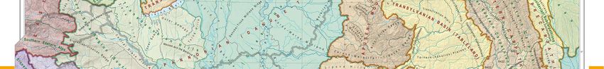
3 of 7

shortly before Hungary's democratic transformation. It is            1:2.5 million. The atlas contained 21 maps of the
four times as voluminous as the first edition. The atlas was         Carpathian Basin (including 16 physical geographical
published in one single volume on 395 pages of 29 x 43               maps), whereas only three maps had shown this broader
cm. Its bilingual (Hungarian and English) edition was an             area in the 1989 edition of the National Atlas. This fact
expression of Hungary's opening to the outside world. The            clearly reflected a major change in attitude.
extent of explanatory texts followed international trends
                                                                     2.8. Károly KOCSIS – Ferenc SCHWEITZER (Eds.):
and significantly increased compared to the 1967 edition
                                                                     Hungary in Maps. Geographical Research Institute,
(from eight pages to 100 pages). Due to the size of
                                                                     Hungarian Academy of Sciences, Budapest. 2009
Hungary, the scale of most of the maps (1:1 million to 1:2
million) did not change. The structure of topics remained            This relatively small-sized atlas (21 x 29.8 cm) gives an
almost the same, reflecting the fact that the primary                overview of the contemporary natural, social and
function of the National Atlas was to facilitate socialist           economic state of Hungary in English for an international
regional planning. About 60% of the 763 maps continued               readership. The Geographical Research Institute of the
to show the condition of the national economy, but the               Hungarian Academy of Sciences published it on the
ratio of maps dealing with social topics and introductory            twentieth anniversary of the democratic transformation in
maps increased slightly (12% and 8% respectively) at the             Hungary, the tenth anniversary of Hungary's accession to
expense of physical geographical maps (21%). When the                NATO, and the fifth anniversary of Hungary's joining the
political climate grew milder in the second half of the              European Union. The publication also formed part of a
1980s, the acquisition of information became easier.                 series of regional atlases on Southeast Europe and Ukraine.
Moreover, it became possible to publish criticism of                 The 211-page atlas was made using digital technology, and
socialist industrialization, agricultural policy and regional        the ratio of texts and maps was about 2:1. The topics of
economics. The contents of the National Atlas reflect such           nature, economy and society were given similar weight
developments (Bassa, 1989; Pécsi, 1989).                             and importance on the 142 maps. Unlike the former
                                                                     national atlases, this English language “business card” of
2.6. Márton PÉCSI (President of the editorial board)                 the country offered new ways of presenting a range of
Magyarország Nemzeti Atlasza kiegészítő lapjai –                     subjects to satisfy domestic and international interest in
National Atlas of Hungary. Supplementary Map Lift-                   Hungary. Such topics included ethnicity, politics,
out Series. 1–5. füzet. MTA Földrajztudományi                        urbanization, commerce, telecommunications, and tourism
Kutató Intézet, Budapest. 1994–1995                                  (Bassa, 2009).
The fundamental social and economic changes after 1989
                                                                     2.9. KOCSIS Károly – SCHWEITZER Ferenc (Eds.):
and the publication of the data of the 1990 population
                                                                     Magyarország térképekben. Geographical Research
census inspired the Geographical Research Institute of the
                                                                     Institute, Hungarian Academy of Sciences, Budapest.
Academy to issue supplementary map sheets to the
                                                                     2011 (Hungary in Maps, in Hungarian)
National Atlas of Hungary with the purpose of quickly
providing society with reliable information. In accordance           This publication is not just the Hungarian version of the
with modern international trends, the editors broke with             atlas published in English in 2009; rather it is an enlarged,
the tradition of publishing a uniform and large volume.              updated, revised and multifunctional edition with the same
Opening up to the general public and the education system            page size (21 x 29.8 cm). With the addition of new chapters
expressed a change in function, as people were becoming              (parliamentary elections, talent geography), the number of
more interested in problem-oriented subject-matter (such             pages increased to 248, the number of maps to 165, and the
as ethnic issues, new public administration, demographic             number of authors to 38. This handy and comprehensive
problems, international migration, elections, taxation,              atlas aimed to give an overview of Hungary in the early
environmental conflicts). Further, map-making switched               years of the third millennium for the average educated
from traditional techniques to digital technology                    person, for people involved in secondary and higher
(ArcGIS).                                                            education, and for decision makers at government level.
                                                                     After the publication of the atlas in conventional printed
2.7. PAPP-VÁRY Árpád (Editor-in-chief):                              form, the full content of the atlas was placed on the
Magyarország atlasza. Cartographia, Budapest. 1999                   homepage of the Geographical Research Institute of the
(Atlas of Hungary, in Hungarian)                                     Hungarian Academy of Sciences, in this way offering fast
This atlas (23.3 x 32.9 cm in size) is much easier to handle         (and free) information.
than were the former one-volume national atlases. The aim
of the publisher was to present, mainly for people involved          3. Editorial policy for the new edition of the
in higher education, the basic social and economic changes           National Atlas of Hungary
that took place in Hungary after 1989. The atlas has 132             Nearly a quarter of a century following its second edition,
numbered pages, with 106.5 pages of maps and 24.5 pages              in 2013 preparations for the new (conventional) edition of
for an index and a list of settlements. Owing to changes in          the National Atlas of Hungary were started – again under
function and the requirements of the targeted users, the             the coordination of the Geographical Institute of the MTA
structure of the map pages differed significantly from the           Research Centre for Astronomy and Earth Sciences
1989 edition of the National Atlas. The ratio of map                 (CSFK) of the Hungarian Academy of Sciences.
themes became more balanced: the ratio of economic maps              It is a unique novelty of our aims that the new edition of
fell from 49% to 23%, while the ratio of introductory                the National Atlas of Hungary presents the dynamic spatial
general geographic and political-administrative maps                 structure of nature, society and the economy not merely for
increased from 10% to 26%. The scale of most maps was                Hungary, but wherever the required data are available, for

Proceedings of the International Cartographic Association, 2, 2019.
29th International Cartographic Conference (ICC 2019), 15–20 July 2019, Tokyo, Japan. This contribution underwent
single-blind peer review based on submitted abstracts. https://doi.org/10.5194/ica-proc-2-64-2019 | © Authors 2019. CC BY 4.0 License.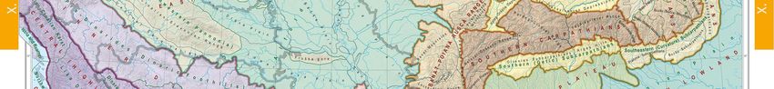
4 of 7

the entire Carpathian Basin and its wider neighbourhood              chapter’s colour, text boxes explaining interesting
(the Carpatho–Pannonian Area), thus covering a territory             professional terms, ideas or phenomena (often containing
of some half a million km² and 34 thousand settlements in            their own graphs and other visuals) add content and help
twelve countries.                                                    the reader use the National Atlas.
It is to be noted that in the National Atlas, we strictly            Each of the subsequent volumes will start with a brief
distinguish the terms ‘Pannonian Basin’ and ‘Carpathian              chapter called Hungary at a glance, overviewing the
Basin’, which are frequently believed to be synonyms.                country’s particulars. The maps included introduce the
While on the one hand, the Pannonian Basin is a                      administrative division of Hungary in the current year, as
geographical and natural phenomenon, meaning the actual              well as the general geographical features, i.e. the
basin between the Alps, the Carpathians and the Dinarides,           topography, hydrography and the settlement and transport
on the other hand, the Carpathian Basin (without                     network of the Carpatho–Pannonian Area.
irredentist connotations), frequently used in colloquial             In the English versions, geographical names (e.g.
Hungarian, covers the historical-cultural homeland, the              topographic, hydrographic and settlement names) are
autochthonous settlement area of Hungarians, in fact, the            given in English in the first place, or when that does not
historical territory of the State.                                   exist, in the given country’s official language. In regions
It has been an additional important objective to compile             where the proportion of national-ethnic minorities is over
and publish high-quality geo-informational background                10%, geographical names are given also in the minority
material for the governance and for public and higher                language, using ethnonyms both in the maps and in the
education. In other words, we intend to make available to            texts.
large sections of the population scientifically well-                Understanding the special significance of the National
established reader-friendly material about Hungary and the           Atlas, in addition to the staff of the Hungarian Academy
Carpathian Basin.                                                    of Sciences (MTA), colleagues from Hungarian
In addition to the conventional (print) version, for the             universities and other organisations and institutions (e.g.
internet-based National Atlas, interactive analysis and              the Ministry of Agriculture, the Mining and Geological
searchability will be enabled; in line with contemporary             Survey of Hungary, the Hungarian Meteorological
technical expectations, we wish to build an interactive              Service, and the General Directorate of Water
digital national geo-information system and upload the               Management) have made their selfless effort in order to
National Atlas content on it. In order to provide foreign            assist this national project.
readers with authentic information of international                  It is worth noting that the two former Hungarian national
standards, in addition to the Hungarian version, it is               atlases were published in characteristic times of the age.
essential to publish the English translation (with the               The first one (issued in 1967) presented Hungary when the
involvement of native English speakers), as well as the              socialist state and economy were consolidated. The second
Hungarian original, of the four upcoming volumes of the              one (produced in 1989) documented Hungary in the last
National Atlas to be produced in the following years and             year of the communist state, just before the democratic
to make them available online.                                       transition from socialism to market economy, and was
For the sake of user-friendliness, each chapter of a volume          ceremoniously presented at the 14th International
has its own colour, which appears on the margins of pages,           Cartographic Conference of the ICA held in Budapest. The
in subtitles, as well as in references to non-verbal                 maps and their accompanying descriptions in the present
information. Unlike in strictly academic publications,               and forthcoming volumes of the third edition illustrate the
however in the same way as in other national atlases, the            modern and market-oriented Hungary in a completely new
chapters only give the authors’ names. Their particulars             political and economic environment. It is almost
(scholarly rank, position, primary employer’s name and               unparalleled that a country has produced three national
town) are specified at the end of each volume (Authors,              atlases within just a bit more than fifty years. This fact
Bibliography and Sources). Due to the nature of the genre,           demonstrates that the Hungarian community of
we do not include any footnotes or references to any                 cartographers, geographers and related sciences has
literature. Therefore, all the sources for the texts, for            always considered it a national and professional mission to
compiling figures, the list of further readings, and names           cultivate the image of the country at home and abroad too.
of photographers are to be found in the Authors,
Bibliography and Sources section on eleven pages. Due to             4. National Atlas of Hungary – Natural
these reasons (and occasionally space limitations), non-             Environment
verbal sources (i.e. maps, tables, graphs, diagrams and              The current 183-page atlas (Figure 1) published in 2018 is
photos) that enrich the topics do not feature the names of           Part 2 of a four-volume project, for Part 1 is planned to
their authors or their origins. Titles of these vital                come out in late 2019. This volume of the National Atlas
components of the National Atlas are included in the lists           of Hungary is headed by an introduction to Hungary’s
of figures, tables and pictures, offering help in focused            natural environment. It introduces the features of the
searching.                                                           lithosphere, hydrosphere, atmosphere, biosphere, and
In the printed version of the National Atlas, two-page maps          environmental protection, as well as nature conservation in
accompanied by detailed information have a special                   Hungary, and whenever possible, in the Carpathian Basin
significance. They are not always placed next to the text            (roughly from 44° to 50° North and 15° to 27° East) to
they refer to because they have to be on facing pages so             highlight the spatial context of the themes. The equivalents
that their middle section should be equally readable. In             of more than 200 English geographical names as used in
addition to these illustrations, highlighted in the relevant
Proceedings of the International Cartographic Association, 2, 2019.
29th International Cartographic Conference (ICC 2019), 15–20 July 2019, Tokyo, Japan. This contribution underwent
single-blind peer review based on submitted abstracts. https://doi.org/10.5194/ica-proc-2-64-2019 | © Authors 2019. CC BY 4.0 License.
5 of 7
the country concerned are to be found in the List of English
and Foreign Place Names at the end of the volume.
The people of Hungary have shown their natural interest
in the geography of the neighbouring countries for a
century, because a major part of the Carpatho–Pannonian
Area was included in the territory of the Kingdom of
Hungary for one thousand years. This explains the new
editorial policy for the National Atlas, owing to which
there are several atlas maps in the thirteen chapters that
show and feature a much larger area (including parts of
Central and Southeastern Europe) than just that of
Hungary within its national borders (Figure 2). This
statement is particularly true for the maps in chapters on
Geology, Geophysics, Waters (Figure 3), Soils, and
Landscapes (Figure 4). Therefore, this volume can also be
considered as a kind of regional atlas that concentrates
mainly on Hungary. This approach of the editors – without
any irredentist overtone – will definitely help the
international English speaking readers to see and interpret
also the geopolitical position of a small country, Hungary
in a broader (global) environment as well as recognize and
understand the geographical unity of this region within
Central Europe.
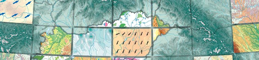
Compared to the sections dealing with the natural
environment in the 1989 edition, the overall length and
number of maps (scales mostly varying between
1:1,000,000 and 1:3,300,000) has doubled, and the
proportion of explanatory texts, tables, graphs and pictures
has increased from 25% to 50%, while the inclusion of Figure 1. The cover page of the National Atlas of Hungary –
photographs appears as a new feature of the National Natural Environment (size 31.0 cm x 42.5 cm).
Atlas. The large-scale case study maps are also an
additional value to the atlas. Thanks to this new approach,
the number of maps covering the Carpathian Basin (scale
1:1,800,000) has risen to 33, and there are as many as 28
small-scale maps of Europe. While in the 1980s the main
themes were centred on waters, geology and the climate,
in the current edition the topics are much more balanced.
Far more space is given to Hungary’s flora and fauna,
nature conservation and landscapes. Compared to its
predecessors, the synthesizing chapter on natural hazards
is completely new.
Finally, the list of chapters is as follows:
I. Hungary at a glance
II. Geology
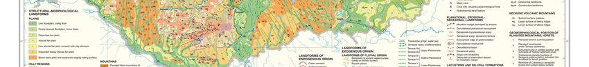
III. Geophysics Figure 2. Geomorphology (original scale 1:1,000,000, pp. 50–
51).
IV. Relief
V. Climate
VI. Waters
VII. Soils
VIII. Vegetation
IX. Animals
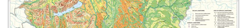
X. Landscapes
XI. Environmental protection
XII. Nature conservation
XIII. Natural hazards
Proceedings of the International Cartographic Association, 2, 2019.
29th International Cartographic Conference (ICC 2019), 15–20 July 2019, Tokyo, Japan. This contribution underwent
single-blind peer review based on submitted abstracts. https://doi.org/10.5194/ica-proc-2-64-2019 | © Authors 2019. CC BY 4.0 License.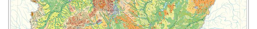
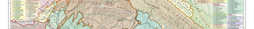
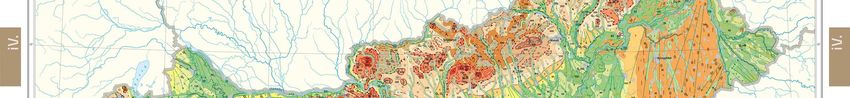
6 of 7

Figure 3. Catchment areas of the Carpatho–Pannonian Area (original scale 1:1,800,000, pp. 74–75).

Proceedings of the International Cartographic Association, 2, 2019.
29th International Cartographic Conference (ICC 2019), 15–20 July 2019, Tokyo, Japan. This contribution underwent
single-blind peer review based on submitted abstracts. https://doi.org/10.5194/ica-proc-2-64-2019 | © Authors 2019. CC BY 4.0 License.
7 of 7

Figure 4. Taxonomy of natural landscapes in the Carpatho–
Pannonian Area (original scale 1:1,800,000, pp. 122–123).

5. References
Bassa, L. (1989), Book review, in Földrajzi Értesítő
 (Geographical Bulletin) (in Hungarian) 38/3–4. pp. 456–
 458.
Bassa, L. (2009), Book review, in Földrajzi Közlemények
 (Geographical Review) (in Hungarian), 133/3. pp. 364–
 365.
Bernát, T., Lackó, L. (1969). Book review, in Földrajzi
 Közlemények (Geographical Review) (in Hungarian),
 93/2. pp. 151–161.
Fodor, F. (1920), Book review, in Földrajzi Közlemények
 (Geographical Review) (in Hungarian), pp. 27–28.
Hanusz, I. (1882, 1884, 1885, 1886, 1888). Book review,
 in Földrajzi Közlemények (Geographical Review) (in
 Hungarian), 1882. pp. 408–414, 1884. pp. 322–326,
 1885. pp. 366–374, 1886. pp. 398–402, 1888. pp. 83–85.
Klinghammer, I. (2008). András Rónai: Atlas of Central
 Europe – a masterpiece of maps, in Földrajzi Értesítő
 (Geographical Bulletin) (in Hungarian), 57/1–2. pp. 71–
 75.
Pécsi, M. (1989). Book review, in Magyar Tudomány
 (Hungarian Science) (in Hungarian) 96/7–8. pp. 545–
 557.
Sziládi, J. (1967). National Atlas of Hungary, in Geodézia
 és Kartográfia. (Geodesy and Cartography) (in
 Hungarian) 19/5. 364–367.

Proceedings of the International Cartographic Association, 2, 2019.
29th International Cartographic Conference (ICC 2019), 15–20 July 2019, Tokyo, Japan. This contribution underwent
single-blind peer review based on submitted abstracts. https://doi.org/10.5194/ica-proc-2-64-2019 | © Authors 2019. CC BY 4.0 License.
You can also read