THE PALEOSURFACE ON THE PASO DEL SAPO VOLCANIC ROCKS, CHUBUT, ARGENTINA
←
→
Page content transcription
If your browser does not render page correctly, please read the page content below
THE PALEOSURFACE ON THE PASO DEL SAPO
                      VOLCANIC ROCKS, CHUBUT, ARGENTINA

               Emilia Yolanda AGUILERA 1,2, Eugenio ARAGÓN1, 3, Silvina CARRETERO                                             1

                 (1) Facultad de Ciencias Naturales y Museo- Universidad Nacional de La Plata.122 y 60, s/n. (1900),
                La Plata. Buenos Aires, Argentina. E-mail: eaguilera@fcnym.unlp.edu.ar; scarretero@fcnym.unlp.edu.ar
                  (2) DAIS - Dirección de Aplicación de Imágenes Satelitales, Calle 7 N° 1267, 2° Piso, B1900TGM.
                               La Plata. Buenos Aires, Argentina. E-mail: aguilera@dais.mosp.gba.gov.ar
                                (3) Centro de Investigaciones Geológicas, Calle 1 N° 644, B1900TGM.
                               La Plata. Buenos Aires, Argentina. E-mail: earagon@cig.museo.unlp.edu.ar

                                                              Introduction
                                                              Study Area
                                                              Geologic Setting
                                                              Materials and Methods
                                                              Results and Discussion
                                                              Conclusions
                                                              Acknowledgements
                                                              Bibliographic References

ABSTRACT – The Deseado and Somon-Cura (or Northern Patagonian) massifs in Patagonia are composed of basement exposed rocks
and they are situated in Patagonia, one of the largest siliceous provinces in the world, with a volume of 235,000 km3, according to
Pankhurst et al. (1995). This Middle Jurassic volcanism has an age of 43 Ma; its age decreases regularly from ENE to WSW along
Patagonia. These volcanic episodes preceded the opening of the Atlantic Ocean and they correspond to a wide extensional province
covering a continental, intraplate region. Most of the Mesozoic topographic features in both massifs are related to Jurassic volcanism and
a NE fracture system. From Jurassic times to the late Cretaceous, the ignimbrite plateau and the stratovolcanoes of the Patagonian
Mesozoic belt have been exposed to an erosion process bringing the massif levelled surfaces to a planation surface. The late Cretaceous
sediments consist of a thin, scattered unit which is distributed on the planation surfaces in the Somon-Cura Massif. A remnant of this
buried planation surface can be observed between Paso del Sapo and Piedra Parada, along the Río Chubut valley. A belt of stratovolcanoes
from the Middle Jurassic (represented by the Alvar Fm.), consisting on lavas, autobreccias and andesitic dykes, was eroded to a sub
horizontal flat, preserving a mantle of regolith which is the product of the underlying vulcanite alteration and it is overlain by quartz
sandstones of the Upper Cretaceous Paso del Sapo Fm. This stratigraphic relationship limits the age of the planation surfaces to Late
Mesozoic times. Thus, this planation surface can be correlated with the Gondwanic planation surface of Lester C. King. Early Tertiary
plate tectonics produced the exhumation of the planation surfaces buried under their own regolith, reactivating erosion surfaces and small
basins.
Keywords: Patagonian massifs, Jurassic volcanic activity, erosion process, planation surface.

RESUMEN – E.Y. Aguilera, E. Aragón, S. Carretero - La paleosuperficie en rocas volcánicas en El Paso Del Sapo Chubut, Argentina.
Los macizos del Deseado y Somon-Cura (o Nordpatagónico) de Patagonia son cuerpos aflorantes de rocas del basamento y una de las
provincias más grandes silíceas en el mundo, con un volumen de 235.000 km3, de acuerdo con Pankhurst et al. (1995). Este vulcanismo
de edad Jurásica media tiene 43 Ma, y la edad disminuye regularmente desde ENE al WSW a lo largo de la Patagonia. Estos episodios
volcánicos precedieron a la apertura del Océano Atlántico y corresponde a una provincia extensional que cubren una amplia región
continental de intraplaca. La mayoría de las características topográficas del Mesozoico en ambos macizos están relacionados con el
vulcanismo Jurásico y un sistema de fracturas NE. Desde el Jurásico al Cretácico tardío, el plateau ignimbrítico y los estratovolcanes del
vulcanismo patagónico del mesozoico han estado expuestos a un proceso erosional que llevan a un nivel la superficies de los macizos a una
superficie de planación. Los sedimentos del Cretácico tardío consisten en una delgada y dispersa distribución sobre esta superficie de
planación en el macizo de Somon-Cura. Un remanente de esta superficie de planación sepultada se puede observar entre Paso del Sapo
y Piedra Parada, a lo largo del valle del río Chubut. Un cinturón de estratovolcanes del Jurásico Medio (representado por la Fm. Alvar),
integrada por lavas, autobreccias y diques andesíticos, se erosiona a una superficie subhorizontal plana, en la que se conserva un manto
de regolito producto de la alteración de la vulcanita subyacente y lasobreyacen en discordancia las areniscas cuarzosas de la formación
Paso del Sapo del Cretácico superior. Esta relación estratigráfica restringe la edad de la superficie de planacion (Ollier, 1992) a los tiempos
mesozoicos tardíos. Así, a esta superficie de planación se la puede correlacionar con la superficie de planacióngondwánica de Lester C.
King (1967). La tectónica del Terciario temprano produce la exhumación de la superficie de planación sepultada en su propio regolito,
reactivando superficies de erosión y las pequeñas cuencas..
Palabras clave: Macizo Patagónico, actividad volcánica jurásica, procesos erosivos, superficie de planación.

                                                          INTRODUCTION
     In Late Jurassic to Late Cretaceous times, the                       have been subjected to extended periods of weathering,
ignimbrite and the Mesozoic Patagonian stratovolcanoes                    whose effects are imprinted on the bedrock through a

São Paulo, UNESP, Geociências, v. 29, n. 4, p. 479-486, 2010                                                                                479
mantle of alteration. Weathering is one of the most          a large valley associated with the Traquetrén fault trace.
important factors involved in the relief degradation. This          From the viewpoint of geomorphologic theories,
work is focused on the study of a volcanic unit that has     the peneplain term - in the sense of Davis (1899, 1909)
developed an alteration mantle in ancient geological         – emerged as surfaces called Peniplains, taken as
periods with the development of a planation surface          the result of fluvial erosion in humid surfaces, and
(Aragón et al., 2005). Through this evidence it is           Pediplain for the extension of pediments in arid areas
possible to infer the geomorphological evolution by          (King, 1949, 1950, 1953). From a detailed study of these
paleogeographic and paleoclimatic reconstructions in         genetic terms and their implications, it is concluded that
the study area. While these units have been the subject      peneplains are very far from being perfect flat surfaces,
of numerous studies related to petrology, tectonics,         but instead, they are low-relief rolling plains (Vidal
structure and stratigraphy, they have rarely been            Romaní & Twidale, 1998). Twidale (1983) argued that
analyzed in terms of their landforms and                     the peneplains continue being gradually degraded and
geomorphological evolution.                                  they are called “ultillanuras” (ultiplains). The
      Authors like Cravero & Domínguez (1992)                transformation is very slow and therefore it enables the
provided evidence of a weathering palaeosurface linked       survival of ancient forms into the current modelling
to the genesis of kaolin deposits in the Barresian-Aptian    (Twidale, 1976). Some authors consider that the
(Early Cretaceous) in Argentine Patagonia. In the case       pediments and pediplains are not genetic or temporary
of the Alvar Andesites, Aragón et al. (2005) identified      peneplains. They are simply parts of a large set called
these planation surfaces, attributing their genesis as a     the planation surfaces (Vidal Romani & Twidale, 1998).
process based on deep weathering (polygenic model).          It is also possible to recognize plains or areas exhumed
More recently, Aguilera (2006) identified a large area       by denudation of geological formations that fossilize the
of regional planation surfaces in Río Negro province,        erosion surfaces. When the alteration material is being
central Northern Patagonia. Ruiz (2006) referred to          eroded by fluvial action, the weathering front appears
this geological formation in terms of the pediment           like an etched surface known as etchplain (Wayland,
surface (developed by erosion of the mountain front          1934), which is referred by other researchers as a
related to the edge of the basin) and / or generation of     chemical corrosion plain (Vidal Romaní & Twidale, 1998).

                                           GEOLOGICAL SETTING
     The Patagonian Jurassic volcanic rocks have been        where the best-known units are the Lonco Trapial
studied and recognized with great interest, among other      Group (Lesta & Ferello, 1972) and the Taquetrén
reasons due to the great areal extension that covers         Formation (Nullo and Proserpio, 1975), in which the
around 1 million km2. Compositional differences in these     Alvar Andesites (Aragón & Mazzoni, 1997) are
volcanic rocks have been observed by different               included and whose lithology is composed by andesites
researchers. In the Eastern sector of the Northern           and trachytes flows and breccias. This Middle Jurassic
Patagonian massif (the Marifil Fm., Malvicini and            age volcanism precedes the Atlantic Ocean opening
Llambías, 1972) and the Deseado Massif ( Bahía Laura         and corresponds to a wide extensional province
Group, Lesta & Ferello, 1972) the composition of the         covering a continental intraplate region.
volcanic units is acidic, while the intermediate to basic         Most Mesozoic topographic features in both
volcanic rocks are concentrated in the central part of       massifs are related to the development of the Jurassic
the Patagonian provinces of Chubut and Río Negro             volcanic activity and a system of NE fractures.

                                                  STUDY AREA
      The study area is located in the province of Chubut,   summers are temperate and winters are not excessively
Patagonia, Argentina, between the Paso del Sapo and          rigorous. The dominant climate is cold-arid. The air
Piedra Parada localities, in the Río Chubut valley           masses coming from the South Pacific Anticyclone
between latitudes 42° 30´00 and 42° 45´00 South and          climb up the Andean Cordillera and discharge their
longitudes 70° 00´00´´ and 70° 45´00´´ West, respectively    moisture in both slopes, and then they suffer an adiabatic
(Figure 1).                                                  warming and originate strong and dry winds which are
      The relief corresponds to the typical extra-Andean     typical of the Patagonian tablelands. Mean annual
Patagonian landscape, characterized by extended and          temperature is 6 °C. Annual rainfall is scarce, oscillating
arid, step-like tablelands. The climate is cold and dry,     between 100-200 mm/yr. The vegetation corresponds
with short summers and endless winters. However,             to the steppe type, with two strata: the shrubs, with

480                                                             São Paulo, UNESP, Geociências, v. 29, n. 4, p. 479-486, 2010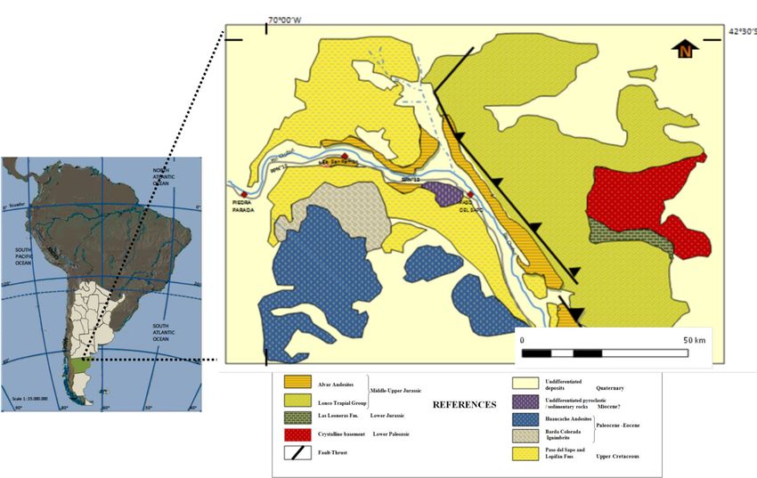
FIGURE 1. Regional location map and simplified geological map showing the distribution
                          of the different geological units and its associated stratigraphy.

species such as “neneo”, “jarilla” and “malaspina”, and        stream bed up to 80 m wide. It flows eastwards,
the herbs, in which hard grasses dominate. Along the           merging with the Horqueta and de la Buitrera wadis.
higher tablelands, the shrubby stratum disappears.             Its discharge depends upon the available rainfall at its
     The Río Chubut crosses the Patagonian tablelands          sources and it shows irregular flash floods in the fall
from West to East, with a whole basin larger than              and winter. It reaches the Florentino Ameghino dam
50,000 km2, with a very swinging stream bed. At Piedra         and from there, it continues until its mouth in the Atlantic
Parada, 19 km before joining the Río Gualjaina, it has a       Ocean.

                                           MATERIALS AND METHODS
      The interpretation and study of the landscape were       satellite imagery data.
carried out by means of aerial photography analysis,                The petrographic analysis of thin sections of the
field surveys, surveying, geological mapping, topography       samples taken in the vicinity of the Estancia San Ramón
digitalization, and a digital elevation model based upon       was completed.

                                      RESULTS AND               DISCUSSION
      A remnant of an ancient paleosurface has been            overlying Cretaceous sedimentation may be observed.
recognized between the localities of Paso del Sapo and         The almost horizontal nature of the paleosurface is seen
Piedra Parada, in the middle Río Chubut valley,                along the entire extent of the outcrop, which increases
developed upon the Alvar Andesites (Aragón &                   in thickness eastwards. The base of the unit (the Alvar
Mazzoni, 1997). A variety of climate processes that            Andesites) is not exposed, because it is covered by the
were active from the Middle Jurassic to the Late               Quaternary fluvial deposits formed by the Río Chubut.
Cretaceous took part in the relief general degradation         The top of the sequence is a sub-horizontal regionally-
of stratovolcanoes, with a resulting planation surface.        stretched surface with gentle slopes that can be
      On both sides of the Río Chubut, the relationship        interpreted as a planation area, which was carved prior
between the surface in the Alvar Andesites and the             to the deposition of the sandstones of the Paso del Sapo

São Paulo, UNESP, Geociências, v. 29, n. 4, p. 479-486, 2010                                                             481
Formation, unconformably lying on top of it. A grayish sedimentary cover is absent the regolith has been
blue regolith, with purple portions, has been developed mobilized and eroded away.
on the volcanic rocks. The regolith texture is 1 m thick, The paleosurface geomorphology is also linked to
clast-supported, with angular clasts of volcanic rocks a topography inherited from the basement structures.
and scarce sandstone epiclastic matrix (Picture 1). Over this topography, which is also a regional planation
The Cretaceous sedimentation in the area has surface, the topography of the Alvar Andesites fits to
fossilized the paleosurface, together with its own integrate the same topographical surface, which was
regolith. This paleosurface is presently being exhumed cited for the Lipetrén area and time-correlated with
by gradual erosion (Picture 2). No absolute dating units like the Mamil Choique Formation (Late Paleozoic
methods have been used so far to date the granitoids) and the Taquetrén Formation (Jurassic
paleosurface. A relative age was estimated based on volcanic rocks) (Aguilera, 2006).
the radiometric age of the Alvar Andesites (Middle The planation process developed upon the Alvar
Jurassic, 161 ± 7.3 Ma), and of the Paso del Sapo and Andesites can be observed at the regional scale where
Lepifán Formations that have buried the paleosurface smooth surfaces with few weakened spots generated
(Late Cretaceous). In such a period between both units, rounded forms (which are known as “whale backs”)
there was time enough to develop a regolith, of which as the main landforms. In a detailed scale, sheets and
a thickness of about 1 m has been still preserved. In flakes break off the surface, and grooves and boulders
the sectors where the Cretaceous formations are can be seen. In some areas the continuity of the surface
observed, the regolith is present whereas where the is interrupted, with scattered outcrops, more resistant to
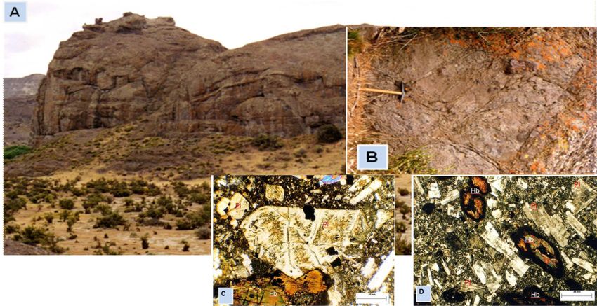
PICTURE 1. General view of the sequence of purple volcanic rocks of the Alvar Andesites,
with no exposed base. The sedimentary rocks of the Paso del Sapo Fm. are unconformably lying on them.
PICTURE 2. Regional view of the planation surface in the Río Chubut valley, near Estancia San Ramón.
482 São Paulo, UNESP, Geociências, v. 29, n. 4, p. 479-486, 2010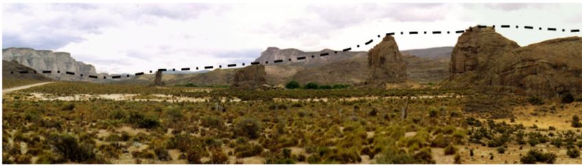
erosion, are found in the shape of ridges that form small        surface and are filled with lens-like sandstones, which
pins to the back of a whale (Pictures 3 and 4).                  include remains of charred stems and leaves and silicified
     Locally, small stream valleys have cut the paleolandscape   trunks (Aragón et al., 2000) (Picture 5).

            PICTURE 3. General view of part of the area in which the broken line indicates the reconstruction
                 of remnants of the planation surface and the surviving inselbergs, developed upon
                         the Jurassic volcanics. At the background, Cretaceous sediments.

      PICTURE 4. Hypothetical reconstruction of the planation surface landscape, with the remaining inselbergs,
       as it was before the deposition of the Cretaceous sediments, which have been removed from this picture.
          The broken line represents the position of the ancient planation surface, before partial denudation.

    PICTURE 5. Small stream valleys have cut the palaeolandscape surface and are filled by lenses like sandstones,
       which include remains of charred stems and silicified trunks. The horizontal position of the Cretaceous
                sediments that were deposited on top of the paleosurface may be easily observed.

São Paulo, UNESP, Geociências, v. 29, n. 4, p. 479-486, 2010                                                             483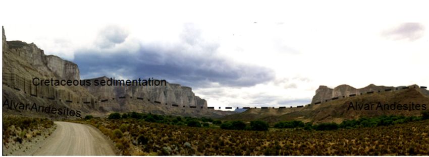
The development of surface denudation (by                 contraction/distention fractures resulting from the
flaking) and differential weathering of bedrock                cooling of the flows.
structural characteristics has allowed the preservation             Through these discontinuity surfaces the meteoric
of more resistant areas in the shape of residual hills         fluids responsible for the alteration of the rock mass
(inselbergs) that are landscape benchmarks as erosion          penetrate. Semicircular /concentric structures are
exposed them.                                                  occasionally seen showing waste materials in transit
     The development of these morphologies seems to            to the lower portions where the rock is still
be directly linked to the geology of the igneous body.         unweathered. As weathering makes progress, the
These extrusive volcanic units, whose primary                  central area of the blocks remains unchanged,
structures are developed in an exogenous environment,          showing rounded corners, covered in reddish loose
are not structurally homogeneous, as they are composed         materials, thus achieving a weathering structure
of lavas and breccias, which usually expose differential       known as the spheroidal type. Spheroidal weathering,
resistance to weathering and/or erosion.                       according to Ollier (1984, 1992), would be linked to
     The lava flows determine horizontal layout                migration of chemical elements inside the rock mass
structures, forming overlapping lava stacks marking            (Picture 6).
planes of structural weakness between them, which                   The flows also present autobrecciation, in which
becomes a favorable area for solution percolation,             there are rounded fragments agglutinated on the same
opening chemical attack routes, and adding a series of         material that is being exposed to weathering and which

     PICTURE 6. (A) Convex dome-shaped hill, of the whale’s back type, showing their sides shelled. At its base,
it can be recognized the horizontal arrangement of the cast that is lost to the roof. With a higher detail, grooves, sheets
     and flakes that break off the surface can be seen. (B) Decomposition of the volcanic rocks from cooling joints,
leading to fragmentation into angular blocks whose boundaries include stretches of peeling or flaking (sheet fractures)
     where weathering made progress. Photomicrographs are showing (C) rounded phenocrysts of plagioclase (Pl),
        crossed by transgranular microfractures. High weathering of hematite into clay minerals has taken place.
       The plagioclase twins have their edges blurred by alteration. Hornblende phenocrysts (Hb) are highlighted
with a significant mobilization of iron oxides from their cleavage planes (crossed nichols) and (D) abundant plagioclase,
   grouped in glomeruli, shows the strong alteration into clay minerals. The plagioclases have zonal alteration which
    can be seen starting from their cores. The crystals are troubled by argillaceous alteration. Details of hornblende
              phenocrysts centers and edges of oxides and opaque minerals can be seen (crossed nichols).

484                                                               São Paulo, UNESP, Geociências, v. 29, n. 4, p. 479-486, 2010
show small fractures, enabling husked forms to lithological and structural anisotropy under the action
generate boulders. Sometimes, the flows are cut by of atmospheric agents. The described landforms belong
dykes with the same petrographical composition. The to a granitic landscape, a broad term which includes
presence of dykes involves fractures and subsequent rocks of varied nature, but with dominant granite. Vidal
fill forcing the occurrence of another type of differential Romaní & Twidale (1998) have recognized weathering
response to weathering and erosion. products in volcanic rocks which were formed under
Breccias show a matrix-supported texture, with hot and humid weather conditions. Although these are
poorly sorted, angular and rounded clasts of volcanic not landforms commonly observed in volcanic rocks,
composition, together with granitic and sedimentary the possibility of their occurrence has been mentioned
lithoclasts. This varying composition explains the by Vidal Romaní & Yepes Temiño (2004).
CONCLUSIONS
The remnants of an ancient planation surface can 83.5-73.1 Ma). Sub-aerial exposure of the Alvar
be observed between the Paso del Sapo and Piedra volcanics was estimated in about 80 Ma, a period long
Parada localities, along the Río Chubut valley, Patagonia. enough for deep weathering processes action and
Field evidence suggests than the stratovolcanoes partial denudation of the unit as weathering made
relief corresponding to the Alvar Andesites had been progress. The chronology and events that such sub-
exposed for an extended period of time to chemical aerial exposure involves helps to improve the
attack by weathering, due to sub-aerial exposure, when understanding of long-term landscape evolution in its
the volcanic rocks underwent a series of chronological context, accepting that the planation
transformations and mineral disaggregation that formed surface persisted with minor changes for very long
an alteration layer (regolith) directly dependent on periods of time.
specific climate conditions and which forced the These stratigraphical relationships restricted the age
development of a granitic landscape. of the planation surface (Ollier, 1992) to Late Mesozoic
The regolith mantle reveals that the climate times, which allows also that it can be correlated with
processes that were active from the Middle Jurassic Lester C. King’s (King, 1967) Gondwanic planation
to the Late Cretaceous were developed in humid and surface, suggesting the possibility of drawing a parallel
warm conditions favoring weathering. Field sequence between this area and the geological and
observations also indicate the presence of small stream climatic history from other regions of the Gondwana
valleys eroded in the paleosurface. Due to this reason, super-continent, before rifting that led towards the
it is inferred that this area was not perfectly flat but opening of the South Atlantic Ocean (Rabassa et al.,
with gentle undulations instead, with irregularities and 1998). Early Tertiary plate tectonic produced the
local depressions where some of the regolith was hosted exhumation of the planation surfaces which were then
and remained safe from denudation and mobilization. buried in their own regolith, reactivating erosion surfaces
The presence of regolith gives an evolutionary and small basins. It is worth noting the importance of
record of these weathering processes. The area has Cretaceous sedimentation, because it fossilized and
been partially buried by Cretaceous sedimentary preserved the andesites and the regolith as an indisputable
deposits and subsequently re-exposed as an exhumed evidence of regional deep weathering.
surface by denudation. The surfaces resulting from Moreover, where the surface has been exhumed,
deep weathering with further regolith mobilization have the horizontal arrangement of the sedimentary strata
been called “etched surfaces” or “etchplains” shows the flat top of the andesites, which acted as the
(Wayland, 1934). This surface was generated in the deposition surface for the Cretaceous units.
Jurassic, perhaps as a consequence of the block According to the tectonic features observed this
uplifting related to the rifting and the South Atlantic region has been a rigid environment without significant
Ocean opening mechanism, which coincided with a subsidence or folds, which only supports block-faulting
tectonic global change from compressive to distension and thrust. These conditions are presently maintained
regimes. Uncomformably overlying this paleosurface, together with its anorogenic characteristics.
the Late Cretaceous quartzitic sandstones of the Paso This contribution represents then a Patagonian
del Sapo Formation are found. The calculated example of a planation area developed on volcanic
radiometric age for the Alvar volcanic rocks is 161 ± rocks, which were later fossilized together with its own
7.3 Ma (Middle Jurassic); the Paso del Sapo Formation regolith, and later exhumed by Late Cenozoic
has been assigned to the Campanian (Late Cretaceous, denudation.
São Paulo, UNESP, Geociências, v. 29, n. 4, p. 479-486, 2010 485ACKNOWLEDGEMENTS
Research presented in this paper was supported by CONICET grants PIP 50/80 and 00/916,
and UNLP 11/534 grants to Eugenio Aragón.
BIBLIOGRAPHIC REFERENCES
1. AGUILERA, E.Y. Identificación y distribución de 15. OLLIER, C.D. Weathering. London: Longman, 270 p., 1984.
distintas superficies geomorfológicas de escaso relieve 16. OLLIER, C.D. Ancient Landforms. London/New York:
local, por medio de sensores remotos en el área del Belhaven Press, 233 p., 1992.
Macizo Nordpatagónico, Provincia de Río Negro. La Plata, 17. PANKHURST, R. & RAPELA, C. Production of Jurassic
2006. 285 p. Doctoral Thesis – Facultad de Ciencias Naturales rhyolite by anatexis of the lower crust of Patagonia. Earth
y Museo de La Plata, Universidad Nacional de La Plata. and Planetary Science Letters, v. 134, p. 23-36, 1995.
2. ARAGÓN, E. & MAZZONI, M. Geología y estratigrafía del 18. RABASSA, J.; ZÁRATE, M.A.; DEMOULIN, A.;
complejo volcánico piroclástico del río Chubut medio CAMILIÓN, M.C.; PARTRIDGE, T.; MAUD, R.,
(Eoceno), Chubut, Argentina. Revista de la Asociación Superficies de erosión y morfogénesis de Tandilia y Ventania.
Geológica Argentina, v. 52, n. 3, p. 243-256, 1997. In: JORNADAS GEOLÓGICAS BONAERENSES, 5, 1998,
3. ARAGÓN, E.; GONZALEZ, P.D.; AGUILERA, E.Y.; Mar del Plata. Actas... Mar del Plata, 1998, p. 111-118.
CAVAROZZI, C.; LLAMBIAS, E.J. Andesitas Alvar: 19. RUIZ, L.E. Estudio Sedimentológico y Estratigráfico de
volcanismo alcalino jurásico en el área de Paso del Sapo, las Formaciones Paso del Sapo y Lefipán en el Valle
provincia del Chubut. Revista de la Asociación Geológica Medio del Río Chubut. Buenos Aires, 2006. 88 p. Graduation
Argentina, v. 55, n. 1/2, p. 44-58, 2000. Thesis – Universidad de Buenos Aires, Facultad de Ciencias
4. ARAGÓN, E.; CARROLL, A.R.; AGUILERA, E.Y.; Exactas y Naturales.
CAVAROZZI, C.E. Ancient Gondwana Landforms in Patagonia 20. TWIDALE, C.R. Geomorphological evolution. In:
In: GONDWANA “GEOLOGICAL AND BIOLOGICAL TWIDALE, C.R.; TYLER, M.J.; WELLS, B.P. (Eds.),
HERITAGE OF GONDWANA”, 12, 2005, Mendoza. Natural History of the Adelaide region. Royal Society
Abstracts... Academia Nacional de Ciencias, 2005, p. 46. South Australia, p. 43-59, 1976.
5. CRAVERO, M.F. & DOMÍNGUEZ, E.A. Evidencias de una 21. TWIDALE, C.R. Pediments, peneplains and ultiplains. Revue
paleosuperficie de meteorización durante el Barresiano- de Géomorphologie Dynamique, v. 32, p. 1-35, 1983.
Aptiano en la Patagonia Argentina In: REUNIÓN 22. VIDAL ROMANÍ, J.R. & TWIDALE, C.R. Formas y
ARGENTINA DE SEDIMENTOLOGÍA, 4, 1992, Buenos paisajes graníticos. Spain: Universidade da Coruña, A
Aires. Actas... Buenos Aires, 1992, v. 3, p. 185-192. Coruña, 411 p., 1998.
6. DAVIS, W.M. The geographical cycle. Geographical 23. VIDAL ROMANÍ, J.R. & YEPES TEMIÑO, J. Historia de
Journal, v. 14, p. 481-504, 1899. la Morfogénesis Granítica. Caderno Laboratorio Xeolóxico
7. DAVIS, W.M. Geographical Essays. Boston: Dover, de Laxe. Spain: A Coruña, , v. 29, p. 331-360, 2004.
777 p., 1909. 24. WAYLAND, E.J. Peneplains and some erosional platforms.
8. KING, L.C. On the ages of African landscapes. Quarterly Geological Survey of Uganda: Annual Report Bullettin,
Journal of the Geological Society of London, v. 104, p. 77-79, 1934.
p. 439-459, 1949.
9. KING, L.C. The study of the world’s plainlands: A new
approach in geomorphology. Quarterly Journal of the
Geological Society of London, v. 106, p. 101-131, 1950.
10. KING, L.C. Cannons of landscape evolution. Geological
Society of America Bulletin, v. 64, n. 7, p. 721-752, 1953.
11. KING, L.C. The morphology of the Earth. 2nd. ed. Edinburgh
and London: Oliver and Boyd, 726 p., 1967.
12. LESTA, P. & FERELLO, R. Región extrandina del Chubut y
norte de Santa Cruz. In: LEANZA, A. (Ed.), Geología
Regional Argentina, Academia Nacional de Ciencias,
Córdoba, p. 601-654, 1972.
13. MALVICINI, L. & LLAMBIAS, E. Geología y génesis del
depósito de Manganeso Arroyo Verde, Provincia de Chubut,
República Argentina In: CONGRESO GEOLÓGICO
ARGENTINO, 5, 1972, Buenos Aires. Actas... Buenos Aires,
1972, v. 2, 185-202.
14. NULLO, F. & PROSERPIO, C. La Formación Taquetrén en
Cañadón del Zaino (Chubut) y sus relaciones estratigráficas
en el ámbito de la Patagonia, de acuerdo a la flora, República
Argentina. Revista de la Asociación Geológica Argentina, Manuscrito Recebido em: 18 de agosto de 2010
v. 30, p. 133-150, 1975. Revisado e Aceito em: 5 de outubro de 2010
486 São Paulo, UNESP, Geociências, v. 29, n. 4, p. 479-486, 2010You can also read