The prehistoric settlement of the inneralpine valley of Montafon in Vorarlberg (Austria)
←
→
Page content transcription
If your browser does not render page correctly, please read the page content below
Preistoria Alpina, 42 (2007): 119-136                                                                            ISSN 0393-0157
© Museo Tridentino di Scienze Naturali, Trento 2007

The prehistoric settlement of the inneralpine valley of Montafon in Vorarlberg
(Austria)

Rüdiger Krause

Johann Wolfgang Goethe-Universität, Institut für Archäologische Wissenschaften, Vor- und Frühgeschichte, Grüneburgplatz 1,
60323 Frankfurt (Main)
E-mail: R.Krause@em.uni-frankfurt.de

       SUMMARY - The prehistoric settlement of the inneralpine valley of Montafon in Vorarlberg (Austria) - The influences
       of prehistoric settlement on the development of landscape and vegetation as well as on cultural processes in an inne-
       ralpine settlement area are examined in an interdisciplinary research project, using the Montafon in western Austria
       as an example. Since the year 2000, data on early settlement history has been obtained from new archaeological exca-
       vations, archaeometallurgical investigations, as well as research on landscape development. Until a few years ago, the
       Montafon was not thought to have been settled until the High Medieval period. Results of recent botanical findings and
       archaeological excavations, however, demonstrate that the use of the area first occurred in the 3rd millennium during
       the Late Neolithic period. Thereafter, in the Early and Middle Bronze Age and the earlier Iron Age settlement activities
       of varying intensity are attested. Scientific investigations of several moors very clearly show the different phases and
       intensity of use of this habitat. In the context of a working hypothesis, it is assumed here that mining and processing
       of copper ores was an important motivation for the Bronze Age settlement of this inneralpine valley.

       RIASSUNTO - Il popolamento preistorico della valle alpina di Montafon nel Vorarlberg (Austria) - Le influenze del
       popolamento preistorico sullo sviluppo del paesaggio e della vegetazione e sui processi culturali in un’area insediativa
       interna alla catena alpina sono esaminati in un progetto di ricerca interdisciplinare, prendendo come esempio l’area di
       Montafon nell’Austria occidentale. A partire dall’anno 2000 sono stati ottenuti dati sulla storia del primo popolamento
       attraverso nuovi scavi archeologici, indagini archeometallurgiche, così come dalla ricerca sullo sviluppo del paesaggio.
       Fino a pochi anni fa, si pensava che Montafon non fosse stato popolato fino al periodo alto medievale. I risultati di recenti
       ritrovamenti botanici e scavi archeologici dimostrano invece che il primo utilizzo dell’area avvenne nel III millennio
       a.C., durante il Tardo Neolitico. Successivamente, negli insediamenti dell’antica e media età del Bronzo e della prima
       età del Ferro sono attestate attività di intensità variabile. Indagini scientifiche effettuate in diverse brughiere mostrano
       molto chiaramente le differenti fasi e l’intensità d’uso di questo habitat. A questo stato della ricerca è ipotizzabile
       che l’estrazione mineraria e i processi di lavorazione del minerale di rame fossero un’importante motivazione per gli
       insediamenti dell’età del Bronzo di questa valle alpina.

       Key words: Austria, Montafon, settlement, environment, metallurgy
       Parole chiave: Austria, Montafon, popolamento, ambiente, metallurgia

1.     Natural setting and fundamental                              the Alps offer diverse and closely situated settlement
       principles of settlement                                     areas and habitats, from lower lying foothills, valley-
                                                                    scapes and inneralpine basins to submontane areas
    The exploration of the peripheral areas of human                to heights beyond the tree line. The history of human
settlement activities is considered one of the intere-              settlement in the Alps is intimately related to the lan-
sting topics of settlement archaeology (Jankuhn 1965).              dscape, the climate and glaciers. There are various
Namely, its aim is to examine settlement processes                  features, which from today’s point of view, would in
that can be attributed to different incentives and mo-              principle render the Alps as an advantageous habita-
tivations of the population and that in pre- and ear-               tional and commercial area: favourable climatic and
ly historic periods ultimately led to the utilisation of            ecological factors, new or modified economic sy-
marginal areas beyond the habitat and into the moun-                stems, settlement pressure due to an increase in po-
tains (Primas 1999; Della Casa 1999). In this respect,              pulation in core zones outside of the Alps as well as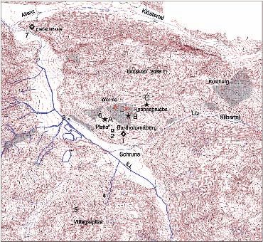
120 Krause Prehistoric
settlement
of
the
Montafon
Valley
prospection for and exploition of ore deposits (Eib-
ner 1982; Wyss 1993).
Permanent or seasonal settlements at the habitat’s
uppermost boundaries are important sources for stu-
dying the interaction between climate, economy and
settlement processes (Aerni 1990: 37 et seqq.; Egli
1990: 54 et seqq.). An increased usage of the Alpine
environment, which is manifested in the numerous set-
tlements, single finds and hoards (von Uslar 1991: 93
et seqq.; Neubauer & Stöllner 1994; Kossack 2002),
as well as long-term settlement activity, as indicated
in pollen profiles (Oeggl 2003), can be noted in the
Early Bronze Age starting at the turn of the third to
the second millennium BC. In addition, there are nu-
merous finds from higher elevations and mountain pas-
ses (e.g. Vonbank 1966), which confirm an intensive
traversing and usage of higher elevations (pastures?),
even above the tree line (Bortenschlager 1992; Wahl-
müller 2002). They as well are an indication of active
exchange and communication between the inneralpi-
ne valleyscapes. In view of the sharp increase of finds Fig. 1 - Map of the Alpine Rhine Valley with the Walgau and
and sites in contrast to the Neolithic, René Wyss has Montafon, showing the major settlements of the Early and
even spoken of “Bronze Age man’s conquest of the Middle Bronze Age (excluding Graubünden). Also indica-
Alps” (“Eroberung der Alpen durch den Bronzezeit- ted are mountain passes in the area of Montafon that were
menschen“, Wyss 1971). important crossings within the inner Alpine region.
Three different explanatory models for the usage of Fig. 1 - Carta della valle alpina del Reno con Walgau e
the Alpine habitat stand out in particular (Primas 1998: Montafon, con i principali insediamenti dell’antica e media
355 et seqq.: 1) the Alpine and upland pastoral economy età del Bronzo (escluso Graubünden). Sono indicati anche
i passi alpini nell’area del Montafon che furono importanti
as a model of a seasonal change of pastures (transhu-
crocevia con la regione alpina centrale.
mance) (Spindler 2005), 2) the traffic crossing the Al-
ps in the course of large-scale exchange as well as in-
tra-Alpine travel between valley communities (Stauf- Bronze Age onwards (Kostenzer 1996). This evidence
fer-Isenring 1983: 135 et seqq.) and 3) the prospection was further supported archaeologically by Bronze and
and exploitation of copper ores. Iron Age finds from the Schrunser basin and from the
Gargellen valley as far as the pass over the Schlappi-
ner Joch (2203 m), thus confirming at least that the val-
2. The archaeological topography ley was traversed in prehistoric times (Vonbank 1966).
of Montafon Ultimately, in 1999, the first prehistoric hilltop settle-
ment was discovered at Bartholomäberg in the Friaga
Situated to the west of the Arlberg and in the south Wald on the Platta (Fig. 2). There primary archaeolo-
of the state of Vorarlberg (Fig. 1), Montafon was, un- gical excavations were carried out by the Institute of
til the discovery of the first fortified, prehistoric hilltop Prehistoric Archaeology of the Free University in Ber-
settlement in 1999, thought to have been an uninhabited lin from 2000 to 2003, revealing Bronze and Iron Age
inneralpine valleyscape in ancient times (Krause 2001: cultural layers of several settlement phases.1 At the sa-
49 et seqq.; Krause 2005b). This view presided despite me time excavations of medieval wall remains at the
the evidence gained through previous pollen analyses Diebschlössle (Fig. 3, no.7), located at the beginning of
from two high moors in Montafon, that attested a con- Montafon, brought forth evidence of Bronze and Iron
tinuous settlement of this valley community from the Age settlement phases.
1
�������������������������������������������������������������������������������������������������������������������������������������
The excavations in Friaga Wald on Bartholomäberg were concluded after four campaigns in August 2003. 12-15 students of the universi-
ties in Berlin, Vienna, Freiberg/Saxony, Tübingen, Oxford (GB) and Moesgard (DK) participated in each campaign. We are very grateful
to the property owners Family Bitschnau and Family Fritz from Platta on Bartholomäberg for their cooperation and patience: without their
generosity, we could not have carried out our work.
Preistoria Alpina, 42 (2007): 119-136                                                                                                121

Fig. 2 - Aerial view of the Montafon landscape seen from the east to the west. In the background are the Raetikon mountains
with heights between 2700 to 2900 metres; in the foreground, the valley and Schruns basin with the confluence of the Ill and
Litz rivers. The settlement at Bartholomäberg is located on a terrace in the upper right. Photograph by Otto Braasch.
Fig. 2 - Vista panoramica del paesaggio del Montafon da est verso ovest. Sullo sfondo si vedono le montagne retiche che
raggiungono quote di 2700- 2900 m. In primo piano, la valle e il bacino dello Schruns con le confluenze dei fiumi Ill e Litz.
L’insediamento di Bartholomäberg è dislocato su un terrazzo in alto a destra. Foto di Otto Braasch.

    The results of archaeological excavations as well as                 of the Montikel above Bludenz with its Bronze Age
of landscape studies by Klaus Oeggl (Institute of Bo-                    pottery is optimal. In the context of investigating the
tany, University of Innsbruck) have shown that prehi-                    ancient history of Montafon excavations were carried
storic settlement in Montafon began around 3000 BC                       out at the Diebschlössle between 2001 and 20032. The
(Krause et al. 2004; Oeggl et al. 2005; Oeggl et al.                     aim was to clarify the age and purpose of the medie-
in press for 2007). Passage through and settlement of                    val walls atop the rock.
Montafon can probably be linked to its easy access to                        Surprisingly, several hundred sherds from the Mid-
the Walgau and its connections across high passes to                     dle Bronze and the earlier Iron Age came to light, whi-
other inneralpine settlement areas in the south, further,                ch are interpreted as settlement deposits and signs of
to the prospection for and mining of copper ores, and                    use of this “rock nest” for its strategically advantageous
perhaps iron ores later in the Iron Age.                                 location (Fig. 4). All finds were located in a relatively
                                                                         thin humus layer or in the clay between the stones and
2.1.      The Diebschlössle near Lorüns and Stallehr                     had been secondarily displaced by later use of the si-
                                                                         te during the Middle Ages. No evidence such as stone
    The Diebschlössle is situated at the entrance to Mon-                placements for houses or hearths was found, so that no
tafon, above the confluence of the Alfens and Ill rivers                 specifications can be made regarding the form and ap-
(Fig. 3, no.7), just beyond Lorüns and Stallehr at the                   pearance of the settlement structures.
eastern end of the Walgau, where the Klostertal leads                        The prominence of the rock formations with their
eastwards to the Arlberg pass (Krause 2006). There to-                   steep faces and the absence of a hinterland for poten-
pographically distinctive rock formations shape the we-                  tial agricultural use give reason to assume that the site
stern foothills of the Davenna Massif into several clif-                 was more likely to have been a location of strategic im-
fs and terraces, atop of which the remains of the walls                  portance above the two valleys and travel routes, rather
of a small medieval castle are still present. From the-                  than a normal rural settlement (a homestead or group
re the view of the eastern Walgau and the rock ridge                     thereof). Of the many hundred, mostly small pottery

2
    Karsten Wink, Firma Arcis in Innsbruck, was contracted by the administrative council of Montafon to carry out the excavations.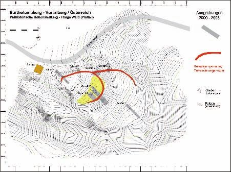
122    Krause                                                                    Prehistoric
                                                                                             settlement
                                                                                                        of
                                                                                                           the
                                                                                                               Montafon
                                                                                                                        Valley

Fig. 3 - Oro-hydrographic map of the southern Montafon with the Bronze Age sites of Diebschlössle (7), the prehistoric hilltop
settlement Friaga Wald (1) and a second site on the Platta (2) on Bartholomäberg. Also indicated (shadowed areas) are zones
of medieval mining debris in the parish Knappagruaba and Worms on Bartholomäberg as well as the Kristberg in Silbertal.
Stars (*) with A, B and C denote three moors from which samples for pollen analyses were taken. Numbers 3, 4 and 5 mark
the sites of occasional finds, among them a flanged celt of the Langquaid type from Hosensee (3). This map is based on the
cataster map from the Bundesamt für Eich- und Vermessungswesen, Wien, and of the communal administration (Stands) of
Montafon in Schruns.
Fig. 3 - Carta oro-idrografica del Montafon meridionale con i siti dell’età del Bronzo di Diebschlössle (7), l’insediamento
preistorico in posizione dominante di Friaga Wald (1) e un secondo sito sulla Platta (2) del Bartholomäberg. Sono indicate
(aree ombreggiate) anche le zone medievali di scarto dell’estrazione nella parrocchia di Knappagruaba e Worms sul Bartho-
lomäberg, così come sul Kristberg nella Silbertal. Gli asterischi (*) con A, B e C denotano tre brughiere da cui sono stati presi
campioni per analisi polliniche. I numeri 3, 4 e 5 indicano siti con ritrovamenti occasionali tra i quali un’ascia a margini
rialzati del tipo Langquaid dal Lago di Hosen (3). La carta è basata sulla mappa catastale del Bundesamt für Eich- und
Vermessungswesen di Vienna e dell’amministrazione comunale (Stands) del Montafone nello Schruns.

fragments, found in different excavation trenches, the             2.2.   The prehistoric hilltop settlement in Friaga Wald
majority of the sherds can be attributed basing on their                  at Bartholomäberg
structure to the inneralpine Bronze Age and, in parti-
cular, to the Middle Bronze Age (16th to 14th century                 The prehistoric hilltop settlement in Friaga Wald at
BC). Amongst the pottery finds are c. twenty sherds,               Bartholomäberg is situated at 940 m above sea level,
some decorated, which according to typological fea-                approximately 240 m up from the valley floor above
tures can be assigned to the Iron Age. As in the case              Schruns and the confluence of the Litz River flowing
of the settlement at Bartholomäberg in Friaga Wald,                out of the Silbertal and the Ill issuing from inner Mon-
there are sherds from the Iron Age Alpine-Rhine val-               tafon (Fig. 3, no.1). The now wooded knoll (Fig. 5) is
ley group as well as the inneralpine Fritzens-Sanzeno              located at the edge of the Platta, a large mountain ter-
group (cp. Fig 12).                                                race facing south, upon which the scattered settlement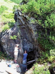
Preistoria Alpina, 42 (2007): 119-136                                                                                      123

Fig. 4 - Middle Bronze Age pottery and a decorated bronze       Fig. 5 - Bartholomäberg, Montafon. In the foreground, the
needle from the settlement in Friaga Wald.                      forested mountain with the prehistoric settlement Friaga
Fig. 4 - Ceramica dell’età del Bronzo medio e punta in bronzo   Wald at the edge of the Platta. View towards the west with
decorata dall’insediamento di Friaga Wald.                      the pointed peak of the Zimba Mountain in the background
                                                                (2643 m asl).
of Bartholomäberg is situated. The eponymous chapel             Fig. 5 - Bartholomäberg, Montafon. In primo piano, la mon-
                                                                tagna alberata con l’insediamento preistorico Friaga Wald
of St. Bartholomae, a well-known landmark, is 1087
                                                                sull’angolo della Platta. Vista verso ovest con la vetta aguzza
m a.s.l. This strategically and topographically exposed
                                                                del Monte Zimba sullo sfondo (2643 m s.l.m.).
point affords extensive views into the distant and sur-
rounding valleyscapes and of the Silvretta Mountains
to the south (Krause 2001; Krause et al. 2004).                 to the hinterland only by a narrow ridge. A trench, ve-
    The Platta once had a hinterland with economical            ry much in the style of a medieval castle’s ditch, was
and agricultural areas.                                         hewn into the rock and cuts off the connection at this
    The moderate elevation and the terrace’s orien-             point. Behind it a steep bank rises 2.5 - 3 m to its hi-
tation towards the south are inducive for agricultu-            ghest point, where a stone wall marks the course of the
re. Due to the favourable climatic factors and intensi-         wall (Figs 6, 9).
ve sun, the location at the Bartholomäberg is descri-               The location of the settlement area on a promon-
bed by the modern tourist industry as the “Sunny Bal-           tory and the relief of the terrain show that the settle-
cony of the Montafon”. A further aspect of prehistoric          ments were built in a protected position. Covering ap-
topography is that travel routes at that time, like tho-        proximately 90 x 50 m, the whole complex is spread
se in historical times, would hardly have run along the         over three levels or plateaus, which are between 920
valley floor, which was at risk of flooding, but rather         and 940 m above sea level (Fig. 6). The settlement
along the slopes.                                               mound itself was notably modified by artificial terra-
    Located atop a rocky spur, the settlement area (Fig.        cing in the Bronze Age (Fig. 7). The planed area thus
6) falls off sharply on the valley side and at first view       created is covered by cultural layers amounting to 1.4
is reminiscent of the topography and inner structure            m in thickness (Fig. 8). The lowest layer dates to the
of a small medieval castle site. The spur is connected          Early Bronze Age (Fig. 8, no. 6.7), followed next by a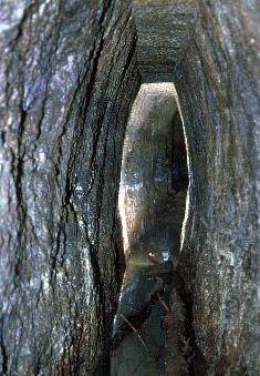
124    Krause                                                                     Prehistoric
                                                                                              settlement
                                                                                                         of
                                                                                                            the
                                                                                                                Montafon
                                                                                                                         Valley

Fig. 6 - Bartholomäberg, Montafon. Topographic plan of the prehistoric hilltop settlement Friaga Wald. The promontory is char-
acterised by terraces and plateaux. Designated are the excavation trenches 1-6 (Schnitt 1-6), the fortification wall encircling the
hillfort and the course of the adjoining terrace wall on plateau 2. Digital documentation by the firm ArcTron, Altenthann.
Fig. 6 - Bartholomäberg, Montafon. Pianta topografica dell’insediamento preistorico in posizione dominante di Friaga
Wald. Il promontorio è caratterizzato da terrazzi e plateau. Sono disegnate le trincee di scavo 1-6 (Schnitt 1-6), il muro di
fortificazione che circonda il castelliere e il corso del muro di terrazzamento sul plateau 2. Documentazione digitale della
ditta ArcTron, Altenthann.

                                                                                            Fig. 7 - Bartholomäberg, Montafon.
                                                                                            The Institute of Prehistoric Archaeo-
                                                                                            logy of the Free University in Berlin
                                                                                            conducted excavations in the fortified
                                                                                            hilltop settlement Friaga Wald on the
                                                                                            Platta in 2000-2003. The photograph
                                                                                            shows investigations on the middle
                                                                                            terrace, which was intentionally level-
                                                                                            led for settlement (cf. Fig. 6, Schnitt
                                                                                            2 and 3).
                                                                                            Fig. 7 - Bartholomäberg, Montafon.
                                                                                            Scavi condotti dall’Istituto di Archeolo-
                                                                                            gia Preistorica della Libera Università
                                                                                            di Berlino nell’insediamento preistorico
                                                                                            in posizione dominante di Friaga Wald
                                                                                            sulla Platta nel 2002-2003. La foto-
                                                                                            grafia mostra le ricerche sul terrazzo
                                                                                            intermedio, che fu livellato intenzio-
                                                                                            nalmente per l’insediamento (cf. Fig.6,
                                                                                            Schnitt 2 e 3).
Preistoria Alpina, 42 (2007): 119-136                                                                                               125

cultural layer from the start of the Middle Bronze Age                 veled layers contained pottery from the Early Bronze
(Fig. 8, no. 4.10) and the latest layer from the earlier               Age, the majority of which are body sherds which eva-
Iron Age (Fig. 8, no. 3.5). By contrast, no traces of set-             de a more exact typological classification. Therefore,
tlement were found on the lowest and uppermost pla-                    samples of charcoal from this oldest cultural layer we-
teaus (s. Fig. 6).                                                     re taken for radiocarbon dating (see above).
                                                                           In the 16th century BC, at the beginning of the Midd-
2.2.1 The Bronze Age settlement in Friaga Wald at                      le Bronze Age, the area was enlarged extensively, more
      Bartholomäberg                                                   artificial terraces were created and a fortification wall
                                                                       was erected (Fig. 9). The central plateau has a terrace
    According to radiocarbon dating, the first settlement              wall, clearly discernible in the terrain, that created an
occurred in the 18th/17th century BC at the end of the                 up to 30 m wide surface of 12-13 m depth. The dark to
Early Bronze Age3. Massive layers of reddish brown                     blackish brown cultural layer measuring 0.3 m contai-
clay, measuring up to 0.4 m in thickness between the                   ned many finds. In this reference, two fire places and a
rock cliffs were leveled in order to create flat surfa-                5 m long foundation of the stone slabs for a house wall
ces (podiums) for houses. Some of the rock was hewn                    are of importance. The back wall of the block buildin-
and stone rows laid out (Fig. 8, no. 7), which served                  gs was formed by the terrace wall. This type of foun-
as the foundations upon which wooden buildings we-                     dation is typical of block buildings in the Alpine area
re erected. However, very little can be stated concer-                 (cf. Rageth 1986). The artificially secured terrace offe-
ning the size and construction of the houses. The le-                  red enough space for about six to eight houses (measu-

Fig. 8 - Bartholomäberg, Montafon. Stratigraphy of the                 Fig. 9 - Bartholomäberg, Montafon. Profile of the fortifica-
habitation layers on the middle settlement terrace in trench           tion wall in trench 4 (cf. plan in Fig. 6). The outer shell (lower
2 (cf. Fig. 6, Schnitt 2). Beneath a cover of forest humus and         left in photo) of the wall was constructed with large stone
a sterile horizontal level (1, 2) are an Early Iron Age layer          blocks, while the inner side was built of smaller rocks that
(3, 5) and a distinct layer marking the horizon of the Middle          are now mostly dislodged. The wall is 3 m wide; its original
Bronze Age (4) with the terrace wall (10) on the left. Below           height was probably 2-3 m. The course of the wall can be
these are the Early Bronze Age horizon (6) with a row of               followed across the terrace (background).
foundation stones (7), and finally the natural bedrock (8).            Fig. 9 - Bartholomäberg, Montafon. Profilo del muro di
Fig. 8 - Bartholomäberg�����������������������������������������
         �������������������������������������������������������
                           , Montafon. Stratigrafia dei livelli abi-   fortificazione nella trincea 4 (cf. la pianta in Fig.6). La
tativi dell’insediamento sul terrazzo intermedio nella trincea         struttura esterna (in basso a sinistra nella foto) del muro fu
2 (cf. Fig.6, Schnitt 2). Sotto una copertura di humus forestale       costruita con grandi blocchi di pietra, mentre il lato interno
e un livello di orizzonte sterile (1, 2) sono presenti un livello      con pietre di dimensioni inferiori che ora sono per la maggior
dell’antica età del Ferro (3, 5) e un livello distinto che marca       parte smosse. Il muro è largo 3 m; la sua altezza originale
l’orizzonte della media età del Bronzo (4) con un muro di              era probabilmente di 2-3 m. Il corso del muro può essere
terrazzamento (10) sulla sinistra. Sotto si trovano gli orizzonti      seguito attraverso il terrazzo (sfondo).
dell’antica età del Bronzo (6) con un allineamento di pietre di
fondazione (7) e, infine, il substrato roccioso naturale (8).

3
 Eight selected samples of charcoal were analysed in the VERA laboratory in Vienna with the AMS radiocarbon dating method (VERA-
3024 – VERA-3030). Cp. Krause 2005.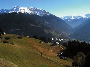
126   Krause                                                               Prehistoric
                                                                                       settlement
                                                                                                  of
                                                                                                     the
                                                                                                         Montafon
                                                                                                                  Valley

ring about 5 x 4 m in size), which were aligned along
the terrace wall.
    The northern flank of the settlement area was pro-
tected towards the mountainside by an approximately
80 m long stone wall (Figs. 6, 9), the collapsed rubble
of which can still be recognized in the shape of a flat
wall today. The wall was of the dry stone shell type and
has a width of 3 m at the top and 2 m on the side (Fig.
9). The adjoining cultural layers show that it was built
after the first Early Bronze Age settlement at the be-
ginning of the Middle Bronze Age in the 16th century
BC (Krause et al. 2004, 7 fig. 11). This massive fortifi-
cation wall that protected the settlement on the moun-
tainside characterises the complex as a fortified Bron-
ze Age settlement or hillfort (Krause 2005a).

2.2.2. The Iron Age settlement in Friaga Wald at Bar-
       tholomäberg

     The Middle Bronze Age settlement in the Friaga
Wald is likely to have existed for about one to two cen-
turies. This was followed by a break of nearly a thou-
sand years, until the site was finally resettled in the
earler Iron Age in the 6th/5th century BC. Fire places,      Fig. 10 - Bartholomäberg, Montafon. The Iron Age cultural
ash pits, foundation remains and post-holes of former        layers in trench 3 (cf. Fig. 6 Schnitt 3) with the Bronze Age
wooden buildings were found in the cultural layer on         terrace wall (below in photo) and various stone alignments
the settlement terrace (Fig. 10). A remarkable feature       that represent the foundations of wooden structures.
is the stone door socket made from a 70 x 50 cm stone        Fig. 10 - Bartholomäberg, Montafon. I livelli culturali del-
slab with a conical hole (Fig. 11). Underlying stones        l’età del Ferro nella trincea 3 (cf. Fig. 6 Schnitt 3) con il muro
                                                             di terrazzamento dell’età del Bronzo (in basso nella foto) e
and foundations made from stone blocks, for the pur-
                                                             vari allineamenti di pietre che rappresentano le fondamenta
pose of planing, are an indication of wooden buildin-
                                                             di strutture in legno.
gs. Four stone slabs placed upon one another formed a
point foundation (Fig. 10). The findings show that the
small buildings stood at least one meter inwards from
the terrace edge and the Bronze Age supporting wall.
Due to the small area excavated little can be stated re-
garding the size and construction of the buildings.
     It was important during the course of the excavations
to clarify whether the nearly 1000 year older fortress
wall of the Middle Bronze Age settlement had been
reused as fortification later on. However, no clues we-
re found that would throw light on this question. Thus,
it is to be assumed that the Iron Age settlement was no
longer fortified in the same way. Further, it must be
assumed, basing on the small settlement area, that as
in the Bronze Age only a few families and therefore
at the most two to three dozen people lived at this si-
                                                             Fig. 11 - Bartholomäberg, Montafon. Flat stone of c. 70 cm
te. Yet, the intensity of the settlement and the cultural    diameter with conical hole for a door-hinge. Found in the
indicators in pollen profiles emphasise that the popu-       Early Iron Age layer in trench 2 (cf. Fig. 6 Schnitt 2).
lation settled at Bartholomäberg during the Iron Age         Fig. 11 - Bartholomäberg, Montafon. Pietra piatta del dia-
was considerably larger and that there must have been        metro di 70 cm circa con foro conico per cardine di porta,
many more settlements, for example, in the form of           trovata nel livello della prima età del Ferro nella trincea 2
compounds or individual homesteads.                          (cf. Fig. 6 Schnitt 2).
Preistoria Alpina, 42 (2007): 119-136                                                                                  127

    The Iron Age cultural layer at Bartholomäberg con-       fied settlement. This finding is indeed of great interest
tained pottery from different inneralpine cultures, in ad-   with regard to the development of the Bronze Age set-
dition to whetstones, loom weights and fragments of          tlement; for apparently after the abandonment of the
bronze fibulae. The finds show that settlement spanned       Middle Bronze Age habitation area, a new settlement
a time of well over 100 to 150 years from the 6th to the     was established at another place, yet within sight of the
5th century BC. Some of the Iron Age pottery exhibits        hillfort in Friaga Wald. This could be interpreted as a
the influence of various inneralpine groups. Amongst         case of small-scale settlement relocation in the course
the finds are sherds of Taminser ware, dated to the la-
te Hallstatt period of the Alpine-Rhine valley (Rageth
1992: 178, fig. 5) and, in addition, so-called Schnel-
ler ware (Fig. 12, no. 2.3) from the Alpine-Rhine val-
ley, which, distributed between Graubünden, Liechten-
stein and Vorarlberg in the south, forms a regional, in-
neralpine cultural group of the late Hallstatt and early
Latène period (Rageth 1992: 186, fig. 9). Eastern in-
fluence is constituted by the Fritzener shallow bowls
of the Fritzens-Sanzeno group (Fig. 12, no.1) (Marza-
tico 1992; Lang 1992), decorated with s-shaped stam-
ps, that are typical of the eastern Alps, South and Nor-
th Tirol as well as the Inn valley; the bowls date to the
early Latène period.

2.3.   A second Bronze Age settlement at Boda Weg at
       Bartholomäberg

    An important objective of archaeological research
and field studies was to locate other prehistoric settle-
ments at the Bartholomäberg and farther in Montafon,
for, as mentioned above, results from archaeobotanical
research on the moors (Oeggl 2003; Oeggl et al. 2005)
have shown that settlement density at Bartholomäberg
must have been much greater in the Bronze as well as
the Iron Age than evidenced by the archaeological fin-
dings thus far. However, initial soundings on exposed
knolls on Bartholomäberg have not produced any fin-
dings and have shown that it will be difficult to find
further settlement locations. Field surveys and syste-
matic drillings with a one-meter drill piece have, ne-
vertheless, yielded an initial, promising result.
    At the centre of the Platta’s large mountain terrace
there are several terraces in the vicinity of Boda Weg
(Fig. 3, no. 2; Fig. 13), where in the summer of 2003
during the course of the prospecting the terrain studen-
ts made several drillings. In different locations over an
area of 20-40 meters, drill cores were retrieved that con-
tained remains of black cultural layers with charcoal.       Fig. 12 - Bartholomäberg, Montafon. Early Iron Age ce-
It was possible to carry out radiocarbon dating on two       ramics from the hilltop settlement in Friaga Wald, showing
                                                             typical Schneller pottery of the Rhine Valley (2, 3) and rim
charcoal samples and calculate absolute calendar da-
                                                             sherds from so called Fritzener bowls (1).
tes based on the dendrochronological curve of annual         Fig. 12 - Bartholomäberg, Montafon. Ceramiche della prima
growth rings. These samples date to the 14th/13th centu-     età del Ferro provenienti dall’insediamento preistorico in
ry BC, that is, the Middle or Late Bronze Age.               posizione dominante di Friaga Wald, che mostrano la tipica
    The topography of the second settlement site shows       ceramica di Schneller della Valle del Reno (2, 3), e frammenti
evidence (Fig. 13) of an open, presumably unforti-           di orlo di scodelle della Cultura di Fritzens (1).
128 Krause Prehistoric
settlement
of
the
Montafon
Valley
Fig. 13 - Bartholomäberg, Montafon. The terrace slope known as Platta in the vicinity of the Bodaweg and a second Bronze
Age settlement site (cf. Fig. 3, no. 2). Drillings were made and samples for radiocarbon dating were taken from this area in
the summer of 2003. The photograph shows geophysical prospection being conducted by the firm Terrana Geophysik. View
to the west: left to right the Golmerjoch, Kreuzjoch (2261 m), the Rells valley and the Zimba mountain (2643 m).
Fig. 13 - Bartholomäberg, Montafon. Il terrazzo inclinato noto come Platta nelle vicinanze del Bodaweg e un insediamento
della seconda età del Bronzo (cf. Fig. , no. 2). In quest’area sono stati eseguiti sondaggi e presi campioni per datazioni al
radiocarbonio nell’estate del 2003. La fotografia mostra prospezioni geofisiche condotte dalla ditta Terrana Geophysik. Vista
verso ovest: da sinistra a destra il Passo di Golmerjoch (2261 m), la Valle del Rells e il Monte Zimba (2643 m).
of the Bronze Age occupation of the Platta. Archaeo- settlement at Bartholomäberg is likely to have been
logical investigations there have been continued in the established at the same time, at 1200 m a.s.l., althou-
summer of 2005 (Krause 2006). gh thus far it has not been located.
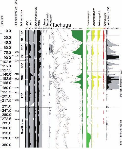
Montafon was settled continuously from around
2500 BC onwards (Fig. 15), whereby several phases in
3. Research on landscape develop- settlement are attested in the pollen diagrams: mode-
ment at Bartholomäberg rate settlement from the Copper up to the early Bronze
Age is followed by an intensive expansion of agricul-
In the course of research on the landscape develop- tural areas during the Middle Bronze Age. In the La-
ment in prehistoric times in Montafon by Klaus Oeg- te Bronze Age there is a notable drop in human activi-
gl, three new pollen diagrams were made from moors ties. The forest clearings are again expanded as of the
(Fig. 14) along a transect in the settlement area at Bar- 6th century, the earlier Iron Age, and this activity conti-
tholomäberg (Fig. 3A-C). Together with the two older nues until Roman times. Finally, medieval land-seizu-
pollen profiles from the surroundings of the Schrun- re takes place between 800 and 1000 AD.
ser Becken (Kostenzer 1996), the diagrams display the
changes brought about in the vegetation and landsca- 3.1. Grain cultivation and gathering economy of
pe in Montafon by human beings since the late Neoli- settlers in Montafon
thic (Oeggl 2003; Oeggl et al. 2005).
The oldest traces of human settlement originate In the course of excavations of the hilltop settlement
from around 3000 BC (Fig. 15). They bear testimony in Friaga Wald on Bartholomäberg soil samples were
to clearing activities that were carried out in the mixed systematically taken and sieved on site in order to analy-
deciduous woods of the valley, which consisted of oak, se charred plant remains from cultural layers of the Ear-
lime, elm and hazel. From there human influence suc- ly and Middle Bronze Age and Iron Age. The analyses
cessively expanded to higher elevations, where it is re- provide important information about food plants and
gistered in pine and fir forests at moderate elevations agriculture of the prehistoric inhabitants of Montafon
at the turn of the Neolithic to the Bronze Age. The first (Schmidl et al. 2005). Analytical research on the char-Preistoria Alpina, 42 (2007): 119-136 129
Fig. 14 - Bartholomäberg, Montafon. The Tschuga moor (1200 m; cf. Fig. 3,B) on Bartholomäberg supplied important infor-
mation about the history of vegetation and settlement in Montafon. To the left, the Hochjoch (2620 m); in the background,
the Sylvretta Mountains of the main Alpine ridge.
Fig. 14 - Bartholomäberg, Montafon. La brughiera di Tschuga (1200 m; cf. Fig. 3,B) sul Bartholomäberg ha fornito importanti
informazioni sulla storia della vegetazione e degli insediamenti nel Montafon. A sinistra, lo Hochjoch (2620 m); sullo sfondo,
i Monti Sylvretta della Catena alpina principale.
red remains is being carried out by Alexandra Schmi- fiable weeds, which today occur as arable weeds and ru-
dl in the Institute of Botany at the University in Inn- derals (Chenopodietea and Secalietea). These agricul-
sbruck (Schmidl et al. 2005). Initial important results tural weeds are indicators of cultivated land in a moun-
show that spelt barley (Hordeum vulgare) was the pre- tainous environment, which is nutrient-rich, has a good
dominant grain in all three settlement phases. Emmer supply of nitrogen and is moderately moist, conditions
(Triticum dicoccum) and spelt wheat (Triticum spelta) that still can be found today on the large mountain ter-
were used in small amounts for breadstuffs. Einkorn race at Bartholomäberg.
(Triticum monococcum), naked wheat (Triticum aesti-
vum) and millet (Panicum miliaceum) appear sporadi-
cally in the soil samples and play only a minor role as 4. Ore deposits and mining in Monta-
food plants. Peas (Pisum sativum) and broad beans (Vi- fon – the question of prehistorical
cia faba) were important providers of protein. They we- and medieval mining activities
re found in all cultural layers of the hilltop settlement.
In addition to cultivated plants, the inhabitants were al- The question as to the possible exploitation of cop-
so dependant upon wild fruits as a dietary supplement. per and iron ore deposits in prehistory takes on impor-
Hazelnut (Corylus avellana), blackthorn (Prunus spi- tant dimensions in research on the prehistoric settle-
nosa), wild rose (Rosa sp.), red-berried elder (Sambu- ment in Montafon. Occasional finds as well as settle-
cus racemosa), black elder (Sambucus nigra), bramble ments of the Bronze Age on Bartholomäberg have al-
(Rubus fruticosus) and raspberry (Rubus idaeus) have so been considered an indication that, in addition to
been identified. These fruits and seeds were gathered agriculture and animal husbandry, the inhabitants in
from hedges and forest clearings in the immediate sur- the 2nd millennium BC were active in mining and pro-
roundings of the settlement. cessing copper ores.
Assumptions as to the location and condition of Based on the mention of nine smelting furnaces in
prehistoric fields are enabled by seed stores of identi- the “Churrätisches Reichsurbar”, it is assumed that me-130 Krause Prehistoric
settlement
of
the
Montafon
Valley
Fig. 15 - Bartholomäberg, Montafon. Simplified pollen profile from the Tschuga moor (cf. Fig. 14) with settlement and
cultural indicators, which testify the use and occupation of this valley since late Neolithic times (after Klaus Oeggl, Inns-
bruck).
Fig. 15 - Bartholomäberg, Montafon. Profilo pollinico semplificato dalla brughiera di Tschuga (cf. Fig. 14) con l’insedia-
mento e gli indicatori culturali, che testimoniano l’uso e l’occupazione di questa valle a partire dal tardo Neolitico (da Klaus
Oeggl, Innsbruck).Preistoria Alpina, 42 (2007): 119-136 131
dieval mining began as early as Carolingian times. Mi-
ning in the High and Late Middle Ages has left distin-
ct traces in the landscape such as heaps, mining debris
and numerous mentions in historical sources (Schei-
benstock 1974, 1996). Many remains of mining ac-
tivities can be found between St. Anton and St. Gal-
lenkirch, the most abundant being in the mining areas
of Knappagruaba and Worms on Bartholomäberg and
on the Kristbergsattel in Silbertal (Fig. 3). They inclu-
de heaps (Fig. 16), mining debris and galleries (Fig.
17), collapsed and filled mine shafts and adit entran-
ces. Common to all is the fact that, thus far, it has not
Fig. 16 - Bartholomäberg, Montafon. Overgrown waste been possible to place them in a more precise chrono-
heaps in the area of medieval mining activities in the parish logical order, and that in only very few cases can they
Knappagruaba (cf. map Fig. 3). be placed in context with traditional mining activities
Fig. 16 - Bartholomäberg, Montafon. Cumuli di rifiuti rico- (Scheibenstock 1996: 41 et seqq.). It is still unclear as
perti di vegetazione nell’area delle attività estrattive medie-
to whether some are the remains from mining in prehi-
vali nella parrocchia di Knappagruaba (cf. carta Fig. 3).
storic times.
4.1. Archaeological research on mines in the Gafluna
valley in Silbertal
In 2003 initial archaeological investigations of mi-
nes were carried out in the Gafluna valley (Krause et
al.2004: 16 et seqq.) in the locality Kupfergruba, whi-
ch resulted in the discovery of a subterranean mine.
A short tunnel, only c. 6-7 m in length had been dri-
ven under a large rock (Fig. 18). The hall-shaped tun-
nel expanded to 3 meters’ width and exhibited typical
traces of fire setting in the shape of irregular, rounded
recesses and bulges in the rock.
Two burnt timbers, which can be linked to the fire
setting, were salvaged from the mine’s fill. Two radio-
carbon datings established that the timbers stem from
the time between 1470 and 1660 AD.4 Therefore, in all
likelihood this is a case of iron ore mining from the la-
te Middle Ages and early modern times.
4.2. Archaeometry – results of the ore and artefact
analyses
Within the framework of archaeometalurgical re-
search, the journey of metal, from the ore deposit to
the finished product, that is, the archaeological metal
artefact, can be tracked, based on trace elements and
Fig. 17 - Bartholomäberg, Montafon. View of an adit
(Schrämmstollen) hewn into the bedrock in the area of medieval
the isotopic ratio of lead. Archaeometalurgical analy-
mining activities, Knappagruaba parish (cf. map Fig. 3). ses of ores from the Montafon and Bronze Age me-
Fig. 17 - Bartholomäberg, Montafon. Vista di una galleria tal artefacts from the southern part of Vorarlberg are
di accesso a una miniera (Schrämmstollen) tagliata nel su- being conducted by Ernst Pernicka at the University
bstrato roccioso nell’area delle attività estrattive medievali in Tübingen (Krause et al. 2004: 14 et seqq.). The-
nella parrocchia di Knappagruaba (cf. carta Fig. 3). reby, advantage is taken of the fact that lead occurs as
4
This concerns the beta measurements: 183714, 3080 ± 40 BP = cal. 1420 – 1260 BC and Beta – 183715, 3040 ± 40 BP = cal. 1400 – 1190 BC.132 Krause Prehistoric
settlement
of
the
Montafon
Valley
copper were selected, extracted under a stereo micro-
scope and prepared. This method ensures the greatest
similarity to the assumed preparation of ores by prehi-
storic miners, who processed much richer ores.
The analyses of the ores and artefacts have shown
that some of the ores from Bartholomäberg and Si-
lbertal overlap with artefact samples in lead isotope
ratios and in trace elements, so that they could, in the
first instance, be regarded as the source material for
Bronze Age copper artefacts (Fig. 19). This, however,
cannot be considered as conclusive, until ore deposi-
ts from larger regions such as the eastern Alps are bet-
ter known. At present, the use of ores from the Mon-
tafon during the Bronze Age cannot be ruled out. The
question as to Bronze Age mining can be answered by
further field studies and more evidence of copper pro-
cessing through slags and mining debris.
5. Historical conclusions: The role
of the Bronze Age hillfort at Bar-
tholomäberg
Hilltop settlements in exposed locations on knolls,
Fig. 18 - Silbertal, Montafon. Traces of mining activities in
promontories or rock ridges, not uncommonly built at
Gafluna at c. 1750 m height. Pictured are two lines of mine elevations of up to 1500 meters, represent the prevalent
shafts (Pingen) and a small subterranean shaft as well as settlement type in the Alps in the earlier Bronze Age. In
several small waste heaps. Excavations in August 2003. spite of their strategic positions, these locations were in
Fig. 18 - Silbertal, Montafon. Tracce di attività estrattive a general additionally secured, a few even with massive
Gafluna a circa 1750 m di quota. Sono disegnate due linee di walls, thus rendering the impression of distinguished,
gallerie minerarie(Pingen), una piccola galleria sotterranea strongly fortified places (Krause 2005a).
e diversi piccoli cumuli di rifiuti. Scavi nell’agosto 2003. In view of its fortification the settlement in the Fria-
ga Wald on Bartholomäberg is addressed here as a hil-
lfort and, hence, as a fortification complex (Figs 6, 9).
an impurity in copper and features an isotope compo- The timeframe of the expansion and the building of the
sition, which is variable and typical of an ore depo- fortification and terrace wall are archaeologically and
sit. The trace element pattern in copper and the iso- stratigraphically well documented and can be dated
topic ratios of lead were compared to ores in Monta- to the 16th century BC, the start of the Middle Bronze
fon and to Bronze Age metal objects. In the case of Age. This date places the site among the oldest Bron-
a correlation between both source parameters, it may ze Age hillforts in the Alps. It is comparable only to
be assumed that the analysed ore constituted the ba- a few, similar settlements in the Alps: the prominent
se material for the objects. However, this evidence is settlements on the Klinglberg at St. Veit (Shennan
not incontestable until all ore deposits from one re- 1995), on the Gschleirsbühel at Matrei on the Brenner
gion are analysed. (Zemmer-Planck 1978) and at Patsch below the Euro-
Twenty samples of Bronze Age metal finds from pa Bridge (Kneußl & Kneußl 1965) of the Brenner hi-
the area of Montafon to Feldkirch in the Rhine valley ghway. The complex of Mutta at Fellers on the Hinter-
were analysed by means of fluorescent X-ray analysis rhein in Graubünden is the best suitable comparison to
and their chemical composition determined. Lead was Bartholomäberg. Excavations there in the 1940s unco-
chemically isolated in a clean room and the concen- vered sections of a fortified settlement (Burkhart 1940-
trations and isotope ratios were measured in a mass 41), located upon a knoll, which was fortified by an en-
spectrometer. Ores from deposits in Bartholomäberg closure wall measuring two meters in width; it dates to
and from Kristbergsattel in Silbertal were analysed the late Early Bronze Age or transition to the Middle
for comparison. Copper minerals from sections rich in Bronze Age (see also Krause 2005a).Preistoria Alpina, 42 (2007): 119-136 133 Fig. 19 - Ratio of the lead isotopes 208Pb/206Pb to 207Pb/206Pb in copper ores from Montafon and artefacts from the southern Vorarlberg. The graph shows the differences among various ore deposits and the groups of artefacts that correlate with them as well as those that do not. Investigations thus far by Ernst Pernicka have shown that there are indeed copper ores in Montafon that could have been exploited during the Bronze Age. Fig. 19 - Rapporto degli isotopi del piombo 208Pb/206Pb a 207Pb/206Pb in minerali di rame dal Montafon e prodotti artistici dal Voralberg meridionale. Il grafico mostra le differenze fra vari depositi minerari e gruppi di manufatti ad essi correlati o meno. Indagini portate avanti da Ernst Pernicka hanno dimostrato che nel Montafon sono presenti minerali cupriferi che potrebbero essere stati sfruttati durante l’età del Bronzo. The fortress wall at Bartholomäberg, with an ori- 6. Future prospects ginal height of two to three meters, was massive and surely did not serve only as a fortification, but also Archaeological excavations, archaeometallurgical manifested the prestige and status of its inhabitants investigations and studies on the history of the land- (Fig. 20). One can hardly assume that it was erected scape on Bartholomäberg and in Silbertal will conti- by a small group of people operating on the basis of nue in the summer of 2005. The line of inquiry will fol- self-subsistence. Such a well fortified establishment low further research on Bronze and Iron Age habita- in a central location is only imaginable against the tion sites in the inner Alpine areas as well as the deve- background of copper ore exploitation. Hence, it be- lopment and dynamics of settlements. Excavations at comes apparent that there was a hierarchy of Bronze a second Bronze Age site on Batholomäberg are par- Age settlements in Montafon, which indicates a struc- ticularly directed towards understanding inner settle- tured society with a governing leadership (s. Krau- ment structure (Krause 2006). More archaeological in- se 2002) that probably held control over mining and vestigations will be conducted in the search for traces metal production. of ore exploitation and prehistoric mining, with the aim
134    Krause                                                                   Prehistoric
                                                                                            settlement
                                                                                                       of
                                                                                                          the
                                                                                                              Montafon
                                                                                                                       Valley

Fig. 20 - Bartholomäberg, Montafon. Reconstruction of the Middle Bronze Age settlement in Friaga Wald, based on the digital
topographic map and archaeological findings (cf. Fig. 6). In the foreground is the fortification wall that encloses the complex
on the mountain’s incline. Behind it is the settlement terrace, formed by the terrace wall, with 6-8 reconstructed block houses,
each with a ground plan of c. 4 x 5 m. The 3D-model by Martin Schaich, ArcTron Dokumentation.
Fig. 20 - Bartholomäberg, Montafon. Ricostruzione dell’insediamento della media età del Bronzo di Friaga Wald, basata sulla
carta topografica digitale e ritrovamenti archeologici (cf. Fig. 6). In primo piano il muro di fortificazione che racchiude il
complesso situato sulla pendenza montuosa. Dietro si nota il terrazzo dell’insediamento formato dal muro di terrazzamento,
con 6-8 ricostruzioni di blocchi abitativi, ognuno con una base di circa 4 x 5 m. Modello 3D di Martin Schaich, ArcTron
Dokumentation.

of determining the function of copper and iron ore de-            (see Project Partners) for enabling this successful and
posits and the role that they played in the prehistorical         pleasant undertaking.
settlement of Montafon.                                               Translation by Miranda and Emily Schalk, Berlin.
                                                                  Project partners: Univ.-Prof. Dr. Rüdiger Krause, In-
                                                                  stitut für Archäologische Wissenschaften, Vor- und
Acknowledgements                                                  Frühgeschichte, Universität Frankfurt��������������
                                                                                                            ; Univ.-Prof.
                                                                  Dr. Klaus Oeggl, Institut für Botanik der Universität
    My gratitude to my colleagues Prof. Dr. Klaus Oeggl           Innsbruck; Univ.-Prof. Dr. Ernst Pernicka, Institut für
and Mag. Alexandra Schmidl of the Botanisches In-                 Vor- und Frühgeschichte der Universität Tübingen;
stitut of the University in Innsbruck, as well as Prof.           Mag. Johannes Pöll, Abteilung Bodendenkmalpfle-
Dr. Ernst Pernicka of the Institut für Vor- und Frühge-           ge des Bundesdenkmalamtes in Tirol in Innsbruck;
schichte of the University in Tübingen, for their frien-          Martin Schaich M.A., Firma ArcTron, Ingenieurbü-
dly and collegial support. I also express my apprecia-            ro für 3D-Vermessung und Archäologie, Altenthann;
tion for the use of their results and information for this        Dr. Andreas Rudigier, administrative council of Mon-
article. Further my thanks are extended to all excava-            tafon; Mayor Martin Vallaster, com. ����������������
                                                                                                        Bartholomäberg;
tion participants and those responsible in Montafon               Mayor Willi Säly, com. Silbertal.
                                                                                           ����������
Preistoria Alpina, 42 (2007): 119-136 135
References Krause R., 2005b - Settlement archaeology and prehistoric
mining: a new interdisciplinary research project in the
Aerni K., 1990 - 1000 Jahre Siedlung und Verkehr im Alpine valley Montafon in Vorarlberg (Austria). Preisto-
schweizerischen Alpenraum. Voraussetzungen und Er- ria Alpina, 39 (2003): 211-218.
gebnisse. In: Aerni K., Egli H.-D. & Fehn K. (Hrsg.), Krause R., 2006 - Zur bronzezeitlichen Siedlungskammer im
Siedlungsprozesse an der Höhengrenze der Ökumene. Montafon. Neue Ausgrabungen in Bartholomäberg, Bez.
Bludenz. Jahrb. VLM, 2005 (Bregenz 2006): 47-60.
Am Beispiel der Alpen. Siedlungsforschung. Archäologie
Krause R., (2007) - Die urgeschichtliche Besiedlung des
- Geschichte - Geographie, 8: 9-42.
Montafon. Zur Archäologie einer inneralpinen Sied-
Bortenschlager S., 1992 - Die Waldgrenze im Postglazial.
lungskammer. In: Rollinger R. (Hrsg.), Montafon 2:
In: Eder-Kovar J. (ed.), Palaeovegetational Development
Besiedlung - Bergbau - Relikte. Von der Steinzeit bis zum
in Europe and Regions Relevant to its Palaeofloristic
Ende des Mittelalters. Schruns (= Band 2 der Reihe „Das
Evolution. �����
Wien: 9-13.
Montafon in Geschichte und Gegenwart“, hrsg. von A.
Burkart W., 1940/41 - Jahrb. Sschweizer Gesellschaft für
Rudigier), (in press).
Urgeschichte, 1940/41: 77.
Krause R., Oeggl K. & Pernicka E., 2004 - Eine befestigte
Della Casa Ph. �����������������������������������������
(ed.), 1999 - Prehistoric Alpine environ-
Burgsiedlung der Bronzezeit im Montafon, Vorarlberg.
ment, society, and economy. Universitätsforsch. Prähist.
Interdisziplinäre Siedlungsforschungen und Montanar-
Archäologie, 55. Bonn. chäologie in Bartholomäberg und in Silbertal. Archäo-
Egli H.R., 1990 - Die Untersuchung der Besiedlungs- und logie in Österreich, 15/1: 4-21.
Entsiedlungsvorgänge im Gebirge als Prozeßforschung: Lang A., 1992 - Von der Hallstattzeit zur Frühlatènezeit in
Fragestellung und Methoden. In: Aerni K., Egli H.-D. & Nordtirol. Bemerkungen zum Beginn der Fritzens-San-
Fehn K. (Hrsg.), Siedlungsprozesse an der Höhengrenze zeno Keramik. Die Raeter. Bozen: 91-115.
der Ökumene. Am Beispiel der Alpen. Siedlungsfor- Marzatico F., 1992 - Il gruppo Fritzens-Sanzeno. Die
������������
Raeter.
schung. Archäologie - Geschichte - Geographie, 8: Bozen: 213-246.
43-67. Neubauer W. & Stöllner Th., 1994 - Überlegungen zu bron-
Eibner C., 1982 - Kupfererzbergbau in Österreichs Alpen. In: zezeitlichen Höhenfunden anhand eines kürzlich in der
Prähistorische Archäologie in Südosteuropa. Südosteur- Ostschweiz gefundenen Vollgriffmessers. Jahrb. RGZM,
opa zwischen 1600 und 1000 v. Chr. Berlin: 399-408. 41: 95-144.
Jankuhn H., 1965 - Siedlungsarchäologie als Forschungsauf- Oeggl K., 2003 - Vegetations- und Siedlungsgeschichte im
gabe. Probleme der Küstenforschung, 8: 1-8. Montafon. Rheticus, 3: 49-59.
Kneußl W. & Kneußl R., 1965 - Die befestigte Siedlung Oeggl K., Kofler W. & Wahlmüller N., 2005 - Pollenana-
Patsch – Europa-Brücke. In: Menghin O. & Ölberg M. lytische Untersuchungen zur Vegetations- und Siedlungs-
(Hrsg.), Festschr. Leonhard C. Franz., Innsbrucker Bei- geschichte im Montafon. In: Rollinger J. & Rollinger R.
träge zur Kulturwissenschaft, 11: 209-220. (Hrsg.), Montafon 1: Mensch - Geschichte - Naturraum.
Kossack G., 2002 - Der zentrale Alpenraum während der Die lebensweltlichen Grundlagen. Schruns
����������������������
(= Band 1 der
Bronze- und vorrömischen Eisenzeit - Institutionen, Reihe “Das Montafon in Geschichte und Gegenwart“,
Sachbesitz und religiöse Ausdrucksformen. In: Kult der hrsg. von A. Rudigier) 183-207.
Vorzeit in den Alpen. Bozen: 285-340. Oeggl K. & Wahlmüller N. (2007) - Der Mensch und die
Kostenzer J., 1996 - Pollenanalytische Untersuchungen zur Umwelt vom Neolithikum bis heute. Ein Beitrag der
Vegetationsgeschichte des Montafons, Ber. Nat.-med. Pollenanalyse zur Siedlungsgeschichte des Montafon. In:
Verein Innsbruck, 83: 93-110. Rollinger R. (Hrsg.), Montafon 2: Besiedlung - Bergbau
Krause R., 2001 - Siedlungsarchäologie und Bergbaufor- - Relikte. Von der Steinzeit bis zum Ende des Mittelalters.
schung: Ein interdisziplinäres Projekt zur Erforschung Schruns (= Band 2 der Reihe „Das Montafon in Ge-
der inneralpinen Tallandschaft im Montafon/Vorarlberg schichte und Gegenwart“, hrsg. von A. Rudigier).
(Österreich). In: Jahrbuch Vorarlberger Landesmuseum- Primas M., 1998 - Der bronzezeitliche Landausbau in den
sverein, Bregenz: 43-61. Alpen. In: Hänsel B. (Hrsg.), Mensch und Umwelt in der
Krause R., 2002 - Sozialstrukturen und Hierarchien - Über- Bronzezeit Europas. ��������������
Kiel: 355-365.
legungen zur frühbronzezeitlichen Metallurgiekette im Primas M., 1999 - Primas, From ficton to facts. Current
süddeutschen Alpenvorland. In: Müller J. (Hrsg.), Vom research on prehistoric human activities in the Alps. ����
In:
Endneolithikum zur Frühbronzezeit: Muster sozialen Della Casa Ph. (Hrsg.),
�����������������������������������������
Prehistoric Alpine environment,
Wandels? Universitätsforsch. Prähist. Archäologie, 90: society, and economy. Universitätsforschungen zur prä-
45-59. historischen Archäologie, 55: 1-10.
Krause R., 2005a - Bronzezeitliche Burgen in den Alpen. Be- Rageth J., 1986 - Die wichtigsten Resultate der Ausgrabun-
festigte Siedlungen der frühen bis mittleren Bronzezeit. gen in der bronzezeitlichen Siedlung auf dem Padnal bei
In: Horejs B., Jung R., Kaiser E. & Terzan B. (Hrsg.), Savognin. Jahrbuch SGUF, 69: 63-103.
Interpretationsraum Bronzezeit. Universitätsforsch. Rageth J., 1992 - Zur Eisenzeit im Alpenrheintal. Die Räter,
Prähist. Archäologie, 121: 389-413. Bozen: 175-211.136 Krause Prehistoric
settlement
of
the
Montafon
Valley
Scheibenstock E., 1974 - Geschichte des Bergbaues im Uslar R. v., 1991 - Vorgeschichtliche Fundkarten der Alpen.
Montafon. In: Stand Montafon (Hrsg.), Montafoner Römisch-Germanische Forschungen, 48.
Heimatbuch. Schruns 1974: 41-51. Vonbank E., 1966 - Höhenfunde aus Vorarlberg und Lie-
Scheibenstock E., 1996 - Bergknappen, Stollen, Erze. Zur chtenstein. Archäologia Austria, 40: 80-92.
Geschichte des Bergbaues im Montafon. Bludenzer Wahlmüller N., 2002 - Die Komperdellalm im Wandel der
Geschichtsbl., 31: 1-63. Jahrtausende. In: Klien R. (Hrsg.), Serfaus. Innsbruck:
Shennan St., 1995 - Bronze Age copper producers of the 71-84.
Eastern Alps. ������������������������������������
Excavations at St. Veit-Klinglberg. Univer- Wyss R., 1971 - Die Eroberung der Alpen durch den Bron-
sitätsforschungen zur prähistorischen Archäologie, 27. zezeitmenschen. Zeitschr. für Schweizerische Archäologie
Schmidl A., Kofler W., Oeggl-Wahlmüller N. & Oeggl K., 2005 und Kunstgeschichte, 28: 130-145.
- Land use in the Eastern Alps during the Bronze Age – An Wyss R., 1993 - Prähistorische Kupfererzgewinnung in den
archaeobotanical case study of a hilltop settlement in the Schweizer Alpen. Zeitschr. für Schweizerische Archäo-
Montafon (Western Austria). Archaeometry, 47: 455-470. logie und Kunstgeschichte, 50: 195-212.
Spindler K., 2005 - Transhumanz. Preistoria Alpina, 39 Zemmer-Planck L., 1978 - Ein bronzezeitliches Gehöft
(2003): 219-225. auf dem Gschleirsbühel bei Matrei am Brenner. Ve-
Stauffer-Isenring L., 1983 - Die Siedlungsreste von Scuol- röff. Des Tiroler Landesmuseums Ferdinandeum, 58:
Munt Baselgia (Unterengadin GR). Antiqua, 9. 157-209.You can also read