Thorpeness Conservation Area Appraisal and Management Plan - DRAFT - January 2022 - East Suffolk Council
←
→
Page content transcription
If your browser does not render page correctly, please read the page content below
Thorpeness
               Conservation Area
               Appraisal and
               Management Plan

               DRAFT

January 2022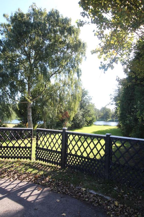
Contents                                              The Benthills                   49
                                                      The Coast Guards                52
1.0    Introduction                       1           The Dunes                       54
                                                      The Haven                       55
2.0    Planning Policy Context            3           The Meare                       59
                                                      The Sanctuary                   61
       Thorpeness Conservation Area Map 5             Uplands Road                    64
                                                      The Whinlands                   68
3.0    Summary of Special Interest        6           Westgate                        71

4.0    History                            8

 4.1   The Historic Settlement of Thorpe 8
 4.2   The Early Development of                ………………………………………………………………………
       Thorpeness                        10
 4.3   The Later Development of                Conservation Area Management Plan      74
       Thorpeness                        15
 4.4   The Significance of Thorpeness    17    Alterations to existing buildings      75
                                               Design & Location of new development
                                               Demolition                             75
5.0    Assessing the Special Interest    18    Enhancement Opportunities              76
                                               Buildings At Risk                      76
 5.1   Location and Topographical Setting 18   Landscape and Trees                    76
 5.2   Archaeology                        20   Listing Opportunities                  77
 5.3   Character of Spaces                20
 5.4   The landscaped setting of the           Contacts                               78
       Conservation Area                  22   Copyright                              78
 5.5   Contribution by Green Spaces
       and trees                          24
 5.6   Key Views                          25   Conservation Area Boundary
 5.7   Setting                                 Review
 5.8   Traditional Building Materials,
       Details, and Colours               27    1) The South Beach, Aldeburgh Road
 5.9   Street Furniture                   31       extension area                     78

                                               Bibliography                           81
6.0    Structures Which Make a Positive
       Contribution to the Conservation        Summary of Special Features Map        82
       Area                             34

       Admirals Walk                     34
       Beach Farm Road                   35
       Beacon Hill Lane                  35
       Church Road                       37
       Dolphin Close                     37
       Lakeside Avenue                   38
       North End Avenue                  44
       Old Homes Road                    44
       Pilgrims Way                      46
       Remembrance Road                  47
       Stony Lane                        48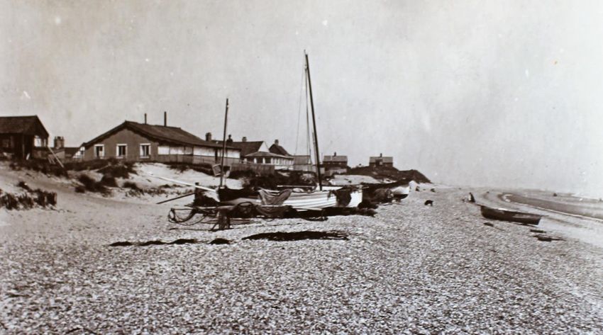
1.0     Introduction

The East Suffolk District currently has fifty one       orderly; it is clear that there is something
designated Conservation Areas, and these                different about Thorpeness.
range in size from small coastal settlements,
such as Dunwich, to larger towns like
Woodbridge and Framlingham, and include
Edwardian coastal resorts, former industrial
complexes and picturesque estate villages.

Thorpeness is a coastal settlement, located
approximately two miles north of Aldeburgh,
and five miles south of Sizewell. Travelling
north from Aldeburgh, the road is parallel to
the coastline with grass, shingle and the sea
to the east, and the wide expanse of marshes
to the west. Across this flat landscape
Thorpeness comes into view, with Westbar,
the Windmill and The House in the Clouds all
forming part of an eye-catching group with
the looming backdrop of Sizewell Nuclear
Power Station.

A dispersed linear group of houses of varying
size, type and age, located against the
coastline marks the start of the southern end
of the settlement. Once within the
Conservation Area there is a sense of a                 Boats, The Meare, the Boathouse and Westbar in
planned development, restricted, polite and             the distance

                                                    1
suggested alterations, which can be found in
the Management Appraisal section.
The role of a Conservation Area is not to
restrict change and development, but to
understand and protect what is important
about an area, and to ensure that proposed
change is not detrimental. By controlling
proposals for demolition, and having tighter
control over design, material use and
Half-timbered houses, The Whinlands
detailing, the intrinsic quality of a
Within Thorpeness, the core of the settlement Conservation Area can be maintained. The
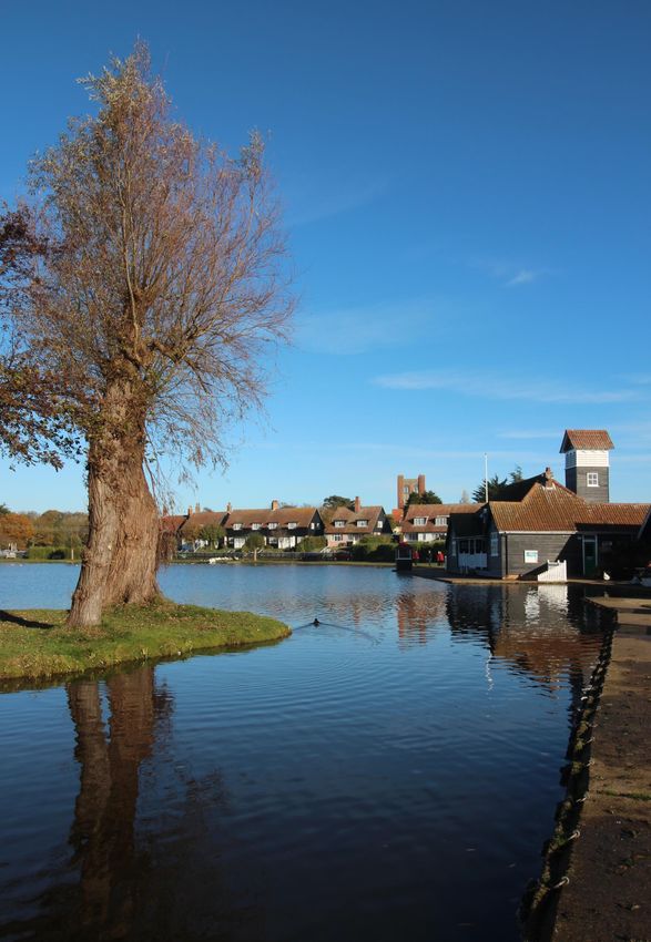
is grouped around a body of water known as appraisal is to be read as a general overview,
The Meare; this, with its adjoining Boathouse rather than as a comprehensive description,
creates a unique atmosphere unparalleled and the omission of any particular building,
within the East Suffolk region. feature or space does not imply that it is of no
interest in conservation terms.
The Meare and the water meadow and
marshes to the south and west of the The Thorpeness Conservation Area has been
settlement were created from the Hundred appraised, and this report prepared, in
River which flows east from Knodishall. To the accordance with the published Historic
north the land rises slightly, with firmer, sandy England guidance document ‘Conservation
soil supporting gorse, heather, birch and oak. Area Designation, Appraisal and
Management’ (Second Edition, 2019).
It is here, between the low flat land to the
south and west, the rising land to the north
and the coast to the east, that the
development of Thorpeness as a holiday
destination commenced during the early 20th
century.
The Thorpeness Conservation Area was first
designated by the former Suffolk Coastal
District Council in 1976 and confirmed by
redesignation in 1991. The last appraisal was
completed during June 2010. The designation
and re-appraisal of Conservation Areas is an
important process and one that is governed
by the Planning (Listed Buildings &
Conservation Areas) Act 1990.
Once a Conservation Area has been
established, the local authority has a duty to
review this periodically. During this latest re-
appraisal a list of ‘Structures Which Make a
Positive Contribution to the Conservation
Area’ has been compiled and the list is
included within section 5.0 of this document. The village sign, located to the green, north east of
A review of the existing Conservation Area the Boathouse
boundary has also been undertaken, with
2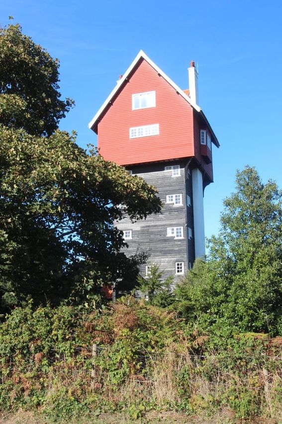
2.0     Planning Policy Context                         Buildings and Conservation Areas) Act 1990.
                                                        The Core Strategy also provides general
The identification and protection of the                advice supporting the retention and
historic environment is an important function           enhancement of Conservation Areas whilst
of the planning system and is done through              minimising any significant adverse impact
the designation of Conservation Areas in                upon them.       Conservation Areas are also
accordance with the Planning (Listed Buildings          included under general development control
and Conservation Areas) Act 1990.                       policies, particularly those in relation to
                                                        design where one of the key criteria requires
Conservation Areas are defined as ‘areas of
                                                        that all new development must have regard to
special architectural or historic interest the
                                                        the character of the area and its setting.
character or appearance of which it is
desirable to preserve or enhance’. These                This Conservation Area appraisal provides
areas make an important contribution to the             details and identifies particular features which
quality of life of local communities and visitors       contribute to and justify its status. The
by safeguarding their physical historical               purpose of this Conservation Area appraisal
features which sustain the sense of local               includes:
distinctiveness, and which are an important
aspect of the character and appearance of our           •       a definition of the special character of
towns, villages and countryside.                                the Conservation Area through its
                                                                special qualities: layout, uses,
                                                                architecture, setting, open spaces and
                                                                archaeology;
                                                        •       an analysis of the area’s history,
                                                                development and current status; and
                                                        •       a guide to managing future change:
                                                                small scale affecting households and
                                                                larger     scale      affecting    new
                                                                development.

View of the pond, looking south west towards the
Boathouse

National planning advice on the identification
and protection of historic buildings,
Conservation Areas, and other assets of the
historic environment is set out in the National
Planning Policy Framework (Chapter 16
Conserving and enhancing the historic
environment) of July 2021.

At the District and local level, the adopted
Suffolk Coastal Local Plan of September 2020
recognises    that     development     within
Conservation Areas will need to accord with
the requirements of the Planning (Listed

                                                    3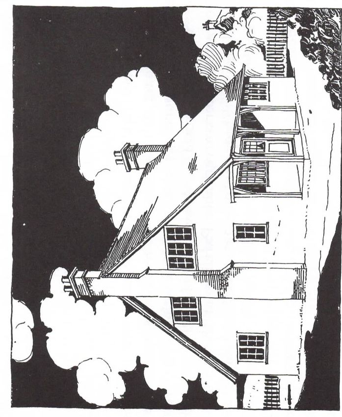
Policy SCLP11.5: Conservation Areas                   Proposals which involve the demolition of
                                                      non-listed buildings that make a positive
Development within, or which has potential            contribution to a Conservation Area, including
to affect the setting of, Conservation Areas           those identified in Conservation Area
will be assessed against the relevant                 Appraisals and Management Plans, will be
Conservation       Area     Appraisals    and         expected to demonstrate:
Management Plans and any subsequent
additions or alterations. Developments should         f) The building is structurally unsound and
be of a particularly high standard of design          beyond technically feasible and economically
and high quality of materials in order to             viable repair (for reasons other than
preserve or enhance the character or                  deliberate damage or neglect); or
appearance of the area.
                                                      g) All measures to sustain the existing use or
Proposals for development           within   a        find an alternative use/user have been
Conservation Area should:                             exhausted.

a) Demonstrate a clear understanding of the           In all cases, proposals for demolition should
significance of the conservation area                 include comprehensive and detailed plans for
alongside an                                          redevelopment of the site.
assessment of the potential impact of the
proposal on that significance;

b) Preserve or enhance the character or
appearance of the conservation area;

c) Be of an appropriate design, scale, form,
height, massing and position;

d) Retain features important to settlement
form and pattern such as open spaces, plot
divisions, position of dwellings, hierarchy of
routes, hierarchy of buildings, and their uses,
boundary treatments and gardens; and

e) Use high quality materials and methods of
construction which complement the character
of the area.

Proposals for development which affect the
setting of a Conservation Area should be
considered against

criteria a), c) and e) above.

                                                  4
Conservation Area Maps

1882 OS Map of Thorpeness

Current Thorpeness Conservation Area and proposed extension

                                                   5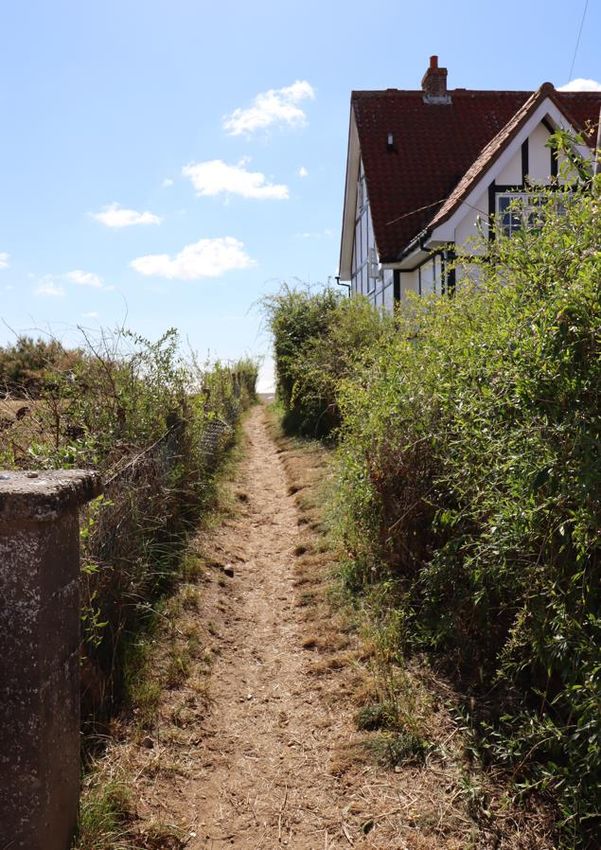
The Meare, looking north west towards Lakeside Avenue, The House in the Clouds and the Windmill

3.0     Summary of Special Interest                      make an exceptional contribution to the area,
                                                         including landmark structures such as the
Thorpeness is a largely the vision of one man,           Windmill, The House in the Clouds, The
Glencairn Stuart Ogilvie (b.1858, d.1932) a              Almshouses and Westbar; all structures that
Scottish landowner who, with the assistance              now define the village. The significance of
of two architects, established and tightly               some of the earliest and best-preserved
controlled the development of a coastal                  houses facing The Meare has also been
holiday resort during the early 20th century.            recognised not only for their architectural
The esteemed architectural historian, Sir                style but also the construction techniques
Nikolaus Pevsner defined Thorpeness as                   employed, including the use of concrete and
“…something extremely rare, a planned                    other fireproof materials.
seaside resort” (The Buildings of England,
Suffolk: East, 2015).

Thorpeness continues to endure as a
destination for tourists, as well as being home
to a number of full-time residents, and this is
in large part testament to the strength of the
original vision, and the unique combination of
the natural and man-made landscape,
recreational facilities and picturesque
architecture.                                            No. 1 The Haven, one of the first phase of houses
                                                         to be constructed
Thorpeness contains few listed structures, but
those that have been statutorily recognised

                                                    6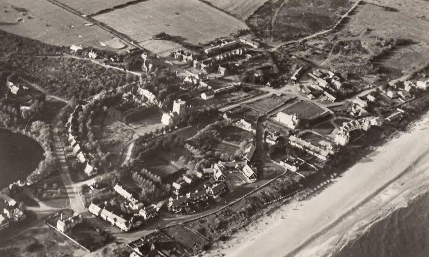
Avenues of houses terminate with focal point            created to facilitate rest and relaxation. At the
buildings (see The Golf Club, Lakeside Avenue,          heart of Thorpeness is The Meare, a focal
Westbar at the top of Westgate and The                  point for residents and visitors, and one that
Almshouses at the head of The Whinlands).               is built around the notion of adventure and
Elsewhere, the character is more informal and           escapism.
the scale modest (Uplands Road). Houses
have been carefully positioned to take
advantage of views of the coastline, green
spaces or The Meare. The area to the north is
more informal and intimate, with several of
the buildings and roads being remnants of the
former Thorpe settlement.

                                                        The close relationship between the built and
                                                        natural environment (The Headlands to the right)

                                                        Developments during the mid to later 20th
                                                        century have, in a few instances, enhanced
                                                        the original concept for Thorpeness, although
                                                        most make a neutral contribution.
                                                        Occasionally infill or replacement dwellings,
                                                        and larger groups of houses have failed to
                                                        respond to the unique qualities of the village
                                                        which has eroded the special quality of
                                                        streetscape and vistas in a few isolated areas.

                                                        Thorpeness is varied in its character;
                                                        occasionally understated, often quirky and
                                                        frequently daring. The quality of the original
                                                        vision, the execution of the early dwellings,
                                                        the planned vistas and the mix of man-made
                                                        and natural landscape features result in a
                                                        village that is unparalleled within the East
Westbar, one of several landmark structures             Suffolk District, and one that is of national
designed and located to draw the eye along              significance.
carefully planned vistas

Architecture makes a significant contribution
to the character of Thorpeness, but landscape
and vistas also play a highly significant role in
the form of carefully planned avenues and
vistas.

The wider natural landscape of coastline,
marshes and heath becomes tamed to the
perimeter of the settlement, particularly to
the north and west of the golf course. Within
the settlement, open spaces have been

                                                    7
Postcard view of c.1905 showing the beach and fishing boats at Thorpe, looking north

5.0     History

4.1      The Historic Settlement of Thorpe
In 1908 Glencairn Stuart Ogilvie inherited the
Sizewell Estate from his mother. On part of
the land that formed the estate was a small,
dispersed fishing village located to the south
of Sizewell Hall called Thorpe, whose name is
likely of Norse origin.                                    Postcard view of c.1900 showing Thorpe

                                                           The Aldringham with Thorpe tithe map (1839)
                                                           shows Thorpe as an open site containing little
                                                           more than a scattering of 19th century
                                                           fishermen’s cottages and an isolated farm
                                                           complex to the north. The 1882 OS map
                                                           shows some growth within the settlement
                                                           and to outlying farms. Kelly’s Directory of
                                                           Suffolk (1900) describes Thorpe as:
Postcard view of Sizewell Hall, prior to the fire of
1921                                                       “…an assemblage of about forty fishermen’s
                                                           huts, intermixed with a few tolerable houses,
The Sizewell Estate had been purchased by                  and a coastguard station, bordering on the
Ogilvie’s parents in 1859 and the house and                seashore, on a bleak, unsheltered beach.
land holding increased over the years to 6000              There is a home for poor children, built in 1874
acres, including areas of heath, marsh,                    by Mrs. Ogilvie, of Sizewell House, and
coastline, arable and pastureland.                         conducted and supported by her entirely”.

                                                       8
The Old Barn, Old Homes Road
Ogilvie, a lawyer by profession but a
Thorpeness beach, looking south, showing a playwright by heart, set about transforming
collection of modest beach structures, many of the gardens and wider landscape around
which pre-date the building of Thorpeness
Sizewell, and he renamed the house Sizewell
For a few years prior to Ogilvie inheriting Hall. By 1910 his attention was focussed on
Thorpe had begun to attract seasonal visitors: Thorpe. Here, the 19th century cottages and
an earlier farm complex, reached by an
“…the little village has been known to the existing network of rough tacks, formed the
faithful few as an ideal seaside Summer basis of his new vision – a holiday resort for
resort. The Country gentry, retired military those who appreciated beauty.
officers, well-known artists and well-to-do
merchants from Norwich, Ipswich, and even
London, have built and occupied bungalows
on the edge of the rolling sand dunes
overlooking the North Sea” (W. H. Parkes,
‘Guide to Thorpeness’, 1912).
The Gunyah, an early beach house dating from
c.1900 and pre-dating the development of
Thorpeness. Still extant and outside the current
Conservation Area boundary
With the building of Thorpeness, the old
structures of Thorpe were retained to add
character to Ogilvie’s set piece settlement.
The area around Beacon Hill Lane retains a
strong sense of the former village.
9Architect’s sketch for ‘A Cottage at Thorpeness’, identified as No.1 ‘Sanctuary House’, The Haven. Reproduced
from ‘A Guide to Thorpeness’, W. H. Parkes, 1912
4.2 The Early Development of The idea was that the village would appear as
Thorpeness though it was not actually ‘planned’ at all; an
organic development rather than the carefully
In sketching out the settlement Ogilvie planned set-piece it actually was.
avoided the ordinary, monotonous, and the
coastal cliches of piers and promenades in Once the concept had been formed by Ogilvie
favour of a more naturalistic setting for his he consulted his friend, the architect W. G.
development. Wilson (b.1856, d.1943); the two men had
previously worked together on the
Ogilvie’s vision was apparently influenced by enlargement of Sizewell Hall, which included
Ebenezer Howard’s book ‘Garden Cities of several garden pavilions and follies which
Tomorrow’ (1898) and the author’s radical echo the stylistic development that was to
views on town planning and healthy living. come at Thorpeness. The help of a second
10architect, Forbes Glennie (b.1872, d.1950)
was sought, and between the three men, the
vision of Thorpeness was shaped.
Undated Postcard of The Meare and the
Boathouse, with Tabard House and Tulip Cottage
behind
During November 1910 a small boggy
landlocked area of water, which was fed by
the Hundred River, flooded creating a large
expanse of shallow standing water. This
Aerial view of c.1930 showing the Windmill and inspired Ogilvie to block the river permanently
The House in the Clouds and Lakeside Avenue laid and construct sluices to contain a 64-acre
out but without structures lake, now known as The Meare. Work on this
progressed through the winter of 1912 with
Houses, called bungalows, would be grouped the formal opening taking place on 11th June
around a new lake, and long or short-term 1913.
lettings of fully equipped houses would be
offered. All services were provided by the Early advertising for Thorpeness emphasised
estate and facilities were on a lavish scale, the similarity between the attractions of The
including domestic staff and daily maids as Meare and the adventures of J M Barrie’s
and when needed. A company was formed fictional characters, and Thorpeness was self-
called ‘Seaside Bungalows Ltd’, which was styled as “The Home of Peter Pan”. This
later renamed ‘Thorpeness Ltd’. association was more than marketing; Ogilvie
The earliest houses were laid out in a formal and Barrie were close friends, and the
and linear way, but in being set amongst the creative influence of the author can be clearly
natural landscape, with scrub allowed to grow seen on Ogilvie and his holiday resort
between properties and open boundaries, a development.
picturesque quality resulted. Each house was
subtly different, which added considerable
interest to the evolving character and
streetscape.
11Postcard view of The Kursaal, nearing completion,
1912
The construction of the houses would rely on
techniques Ogilvie learned from his father
Alexander Milne Ogilvie (b.1812, d.1886), a
Civil Engineer. Although appearing to be half-
An early drawing for the first new house at timbered the reality was houses built from
Thorpeness, reproduced from ‘A Guide to poured concrete, with the speed and
Thorpeness’, W. H. Parkes, 1912 relatively low cost of this approach being
In promoting the holiday village, it was particularly well suited to the development.
emphasised that no two houses were exactly Elsewhere, construction was timber framed
the same. While diversity and an eccentric and clad, for both houses and public buildings,
character were the inevitable consequence of including the Boathouse, The Kursaal (a
adopting so many contrasting building styles, country club) and the delightful cabin-
the development achieves a visual unity bungalows on The Uplands.
primarily through Ogilvie’s unwavering desire Westgate, off The Whinlands, has perhaps the
for quality enhanced by landscape. most eccentric character, with each house
varying considerably in design to the next;
there is no set style or rhythm, and the lane is
terminated by the extraordinary towering
gate house of Westbar.
Rail access to Thorpeness was essential for
the continued growth of the resort, and in
1914 Thorpeness Halt was opened on a
branch line from Saxmundham, operated by
Great Eastern Railway. Historic photographs
show a simple concrete platform with
View of chalet bungalows, The Uplands
redundant railway carriages being used for a
waiting room and railway personnel
Three principal areas of housing were laid out;
accommodation. The station was downgraded
Lakeside Avenue, The Uplands and The Haven
to an unmanned stop in 1962 and closed in
leading to The Whinlands. All were grouped 1966.
around The Meare, with the gardens of
houses to the south of Lakeside Avenue
continuing to the water’s edge. These early
houses were basic, and indeed only for
summer or weekend occupation.
12The Meare, looking north west towards Lakeside
Postcard view of c.1960 showing The Dolphin Inn, Avenue
prior to fire and later redevelopment
Thorpeness is not short of strategically placed
The existing Crown Inn of Thorpe was landmark structures, often used to terminate
enlarged and renamed The Dolphin Hotel. The vistas along a road or more informally
Dolphin was destroyed by fire in 1996 and grouped as eye catchers, drawing attention
rebuilt in its present form. towards the boundaries of the settlement.
Two structures that provide this role were the
By 1914 the new village was formally opened, Windmill and the House in the Clouds.
and by the spring all available houses had
been let. Yet this initial promise was short
lived, and with the announcement of War
during August 1914 work ceased. The grounds
of Sizewell Hall were used as a camp for
soldiers and labour diminished as men signed
up to fight for their country.
However, work continued throughout the
1920’s. An extensive planned development to
the north was proposed, with long tree-lined
avenues and spaces between linked by short
roads with houses radiating either in semi-
circular or circular form. A rotunda was also
proposed, and areas of planned lawn linked
the avenue to the sea. Ogilvie’s commitment
to providing interesting public spaces is clear
to see, as was his ambition, yet financial
constraints for the estate meant that towards
the end of the decade, houses had to be sold
off as leasehold, and individual plots, of
varying size and location were made available
for lease and with prescriptive covenants
attached to control development quality. The Windmill, The Uplands
The Windmill initially appears as a relic
remaining from the earlier Thorpe settlement,
but this is far from the case. Dating from 1803
the former corn mill was originally located at
Mill Hill in Aldringham and was purchased by
13Ogilvie, despite strong opposition from the protected as statutorily designated heritage
estate who doubted the economic viability or assets.
practicality of it being restored and re-erected
in Thorpeness. For Ogilvie, the Windmill
represented more than utility, it was a
determined statement of conservation driven
by a desire for enhancement and
beautification. Ogilvie was creating a feeling
of history and permanence in his new village,
as well as providing striking structures that
could be enjoyed by visitors.
However, Ogilvie had even greater ambition;
the Windmill would pump water to a new
water tower, and this would have a capacity
English vernacular, freely interpreted with
of 30,000 gallons. It would be practical, but
picturesque composition
also ornamental, and would have
accommodation below the storage tanks. By Individual building styles emphasise the
September 1923 the steelwork for the water romantic picturesque, especially the larger or
tower had been erected, Ogilvie had named it
more prominent buildings. The architecture is
“Gazebo” and standing at 70 feet in height,
very much a recreation of the English (if not
few can have been in any doubt about the
vision and determination of the man behind specifically Suffolk) vernacular, in many
it. instances very freely interpreted.
The houses located closest to the sea tend to
be single storey and modest, as though
sheltering amongst the dunes from the
prevailing wind. They are generally dispersed
and increase in size towards the north and
west.
The House in the Clouds, The Uplands
The House in the Clouds, as Gazebo was later Sketch view by Forbes Glennie for Tulip Cottage,
renamed, is now an iconic structure and both Remembrance Road. Reproduced from ‘A Guide to
it and the Windmill are recognised and Thorpeness’, W. H. Parkes, 1912
14Approximately one hundred houses of varying
sizes were constructed, all supported by a
Country Club, a Public House, and a
Boathouse. Additionally, buildings were
provided for use by the estate and its staff,
notably the Almshouses and the Workmen’s
Club, both completed during 1928.
Houses to the south side of Lakeside Avenue, seen
from The Meare
The final phase of building work continued
through the 1930s until c.1938. St Mary’s
Church, which had been designed by W. G.
Wilson in 1925 and the land set aside, was
completed in 1936. A large block of residential
Postcard view of The Golf Clubhouse, Lakeside apartments called The Headlands (originally
Avenue, c.1950 called The Crescent) was built 1937 and was
also designed by W. G. Wilson. The sparsely
The Golf Clubhouse of 1929/30 is challenging detailed curved form owes more to art deco
to define architecturally, adopting a fort-like hotels than the Arts and Crafts principles seen
stance with castellated detailing to the elsewhere, yet somehow this non-compliance
entrance, with a square plan tower with an with its surroundings seems acceptable
oast house style roof and four unusual lead alongside the architectural eccentricity of the
stick finials to each corner. It was a unique village. The Headlands represents the last
piece of design, and it displays that the estate building erected following the vision of Ogilvie
appreciated the necessity of, and investment and his architects and it shows clearly how far
in, the provision of high-quality public the initial concept had developed since the
buildings. commencement of the project.
Financial difficulties including the need for
capital saw No’s 2 and 3 The Haven sold on
4.3 Later Development
99-year leases, with ground rents payable to
Ogilvie died in 1932 and control of the estate the estate.
passed to his son, A. Stuart Ogilvie, although it
A reduction in the tariffs charged by the
was run by his uncle and guardian Lt. Colonel
estate saw an influx of tourists during the
Sholto S. Ogilvie until 1945.
1930s and an increase in repeat bookings. The
During this time the business was number of day visitors also increased
streamlined, and financial and legal advice something the original vision for the resort
was sought from firms in London. Sizewell Hall had aimed to avoid. During this period
was let, and attention turned to the existing buildings and facilities were
profitability of the arable farms surrounding modernised.
Thorpeness and Sizewell.
15Aerial view, c.1940, of Thorpeness
structure erected prior to the outbreak of
war. The War Office requisitioned The
Country Club, a number of houses and also
Sizewell Hall, and sea defences and mines
were placed along the coastline.
Post war building restrictions, coupled with
labour and material shortages, meant that
little was added to Thorpeness in the decade
following the Second World War.
From the 1950s onwards land was sold to
private developers and with it the already
diverse range of building styles became more
varied. Some stylish houses resulted from
this, but other buildings did not fully adhere
to the original ‘planned village’ concept and
the vision became diluted as a result.
During the early 1970s the Ogilvie Estate was
devastated by death duties following the
death of Stuart Ogilvie, Glencairn Stuart
Ogilvie's son. This resulted in parts of the
Concrete anti-tank cubes between the coastline village being sold off to raise capital. By 1972
and The Headlands
the estate had begun to break up, and
individual houses came into the ownership of
The Second World War brought to a halt
private individuals. Finally, Thorpeness Ltd
building works, the completion of The
was put into voluntary liquidation, and by
Headlands in 1937 being the last significant
162000 the only part of the village owned Thorpeness is the earlier of the two resorts,
directly by the Ogilvie family was The Meare. built largely between 1912 and c.1938.
There are further similarities between
4.4 The Significance of Thorpeness Thorpeness and Portmeirion. Firstly, Williams-
Ellis was determined to construct a
Much is made of the connection between
picturesque coastal village on a new site. The
Thorpeness and the better-known resort of
idea of a resort village was established from
Portmeirion (northwest Wales). Both share
the beginning, with houses let out to the
coastal locations but architecturally they are
wealthy middle class for seaside recreation on
very different. What actually links them is not
a self-catering basis, just as at Thorpeness a
tangible, but vision and ambition, and that
decade earlier. The planning of the
both areas were largely the work of one
development, like at Thorpeness, was
visionary man.
deliberately ‘random’ in an attempt to create
Both Ogilvie and the creator of Portmeirion, a picturesque quality, and a landscape
the Welsh architect Clough Williams-Ellis studded with landmark structures.
(b.1883, d.1978), were driven by aesthetics;
Given the site of Portmeirion, densely treed
Williams-Ellis wanted to demonstrate that the
with a steep topography of cliffs leading down
‘development of a naturally beautiful site
to the sea, a rather more spectacular site
need not lead to its defilement’ and Ogilvie,
ensured dramatic vistas, building forms and
keen to establish a garden village and avoid
public spaces. However, it is not always the
the invasion of trippers, wanted to create an
case that the individual buildings are
area that would attract those who
themselves architecturally superior to those
appreciated beauty.
at Thorpeness, and it must be acknowledged
The site for Portmeirion, previously called that each resort responds in its own way to
Aber Iâ, was acquired in 1926 and an existing the characteristics of its setting.
house of 1862 was converted to a hotel. The
character of the Portmeirion buildings are The creators of Thorpeness can claim primacy
almost entirely Italianate, suggesting that of for being the first in Britain to establish a
an Italian fishing village, albeit a rather grand resort village. Additionally, it must be noted
one. Several structures were re-erected from that the holiday chalet concept, later typified
elsewhere, including the spectacular c.1760 at Butlin’s, is seen at Thorpeness as early as
Arnos Court bathhouse colonnade from 1919 with the construction of twelve
Bristol, re-erected in 1959. Other buildings bungalows known as The Uplands.
incorporate salvaged architectural fragments,
which adds greatly to the interest of the The national significance of Thorpeness seems
architecture and the settlement. until recently to have been overlooked. The
village was designated as a Conservation Area
Williams-Ellis declared that his choice of in 1976, but it was only in the mid-1990s that
Italian architectural style was intended to a handful of the original holiday buildings
revitalise popularism in architecture and in were listed. The early 19th century postmill,
this he was influenced by the attention moved to the site in the 1920s, was assessed
received in the press regarding the and listed in 1951, but nothing else at this
construction of Thorpeness. time was considered of merit and the area
remains under-protected by national
Portmeirion developed in two main phases;
designation. At Portmeirion, the majority of
the first being 1926 to 1939, and the later
the buildings were listed in 1971 which has
phase being 1954 to 1973. Significantly,
ensured the successful protection and
17preservation of Williams-Ellis’s cohesive
vision.
Understated picturesque simplicity; one of a group
of chalet bungalows, The Uplands
What was created at Thorpeness,
Architect’s plan showing the layout for The
undoubtedly interesting as it exists, was only Netherlands, an unexecuted proposal for fourteen
part of the vision. The planned but unbuilt houses to the south of The Meare. Reproduced
areas of ‘The Netherlands’ and ‘North End’ from ‘A Guide to Thorpeness’, W. H. Parkes, 1912
are discussed elsewhere, but Ogilvie had even
greater vision. A hotel was planned, with
capacity for over 400 guests, and below this 5.0 Assessing the Special Interest
was to have a been an arcade of commercial
units. Called The Mermaid and The Rows it 5.1 Location and Topographical
owed something of its design to the Rows, Setting
Chester, particularly the half-timbered
elevations and balustraded walkways. Thorpeness lies within the Suffolk Coast and
Preliminary sketches show it to have been a Heaths Area of Outstanding Natural Beauty
dramatic and ambitious scheme, and a further (AONB) and the Heritage Coast. The
example of the exemplary planned surrounding landscape, including the golf
development. course, the common to the north and The
Meare, are classified as Sites of Special
Thorpeness is therefore only part of an even Scientific Interest (SSSI) and forms part of
more accomplished vision, and one that Two RSPB and Suffolk Wildlife Trust reserves.
World Wars and the resulting labour, material
and financial difficulties curtailed. What was The geology is that of the Suffolk ‘sandlings’
created at Thorpeness, however, is an coastal strip, crag deposits of sand and gravel
important and early example of a planned laid down during the Pliocene period over
garden village resort of local and national chalk at greater depth. The soils are deep well
significance.
18drained and sandy, forming heathland where perimeter of the water. Immediately to the
well grazed. east of The Meare is the village pond.
Gardens backing onto the dunes and the shingle The Benthills, the rising topography is reflected in
beach the design of the dwellings
To the east are dunes and coastline. The road Beyond this, to the north and west, the
to the south of Thorpeness, which links the topography climbs steadily, and the landscape
village to Aldeburgh is linear and exposed to is considerably higher above sea level than
the marshes and the coastline. the southern parts of the settlement. This is
best seen from The Benthills and the rising
gradient towards Church Road. Further north
are areas of naturally grazed scrub and
bracken, crossed by a number of paths, with
areas of dense scrub comprising gorse,
hawthorn and brambles. Areas of birch and
sycamore woodland provide a diverse habitat.
To the south is an area of shingle, between
the sea and private gardens, which is
particularly susceptible to change through
erosion.
Village pond, to the east of The Meare, looking
towards The Dunes
The centre of Thorpeness, around the
The golf course, with the wider natural landscape
Boathouse, is flat. The Meare, a large area of
beyond
standing water of regular shallow depth has
areas of swamp and woodland to the
19The western side of the village is enclosed by 5.3 Character of Spaces
the golf course, an area of 150 acres of
heathland remodelled by James Braid in 1922.
Around this the setting is mainly grassland
with areas of birch trees and bracken.
Access to Thorpeness via road is by a minor
coast road going south to Aldeburgh and an
inland road, the B1353, which enters
Thorpeness at the northwest and continues to
Aldringham and Leiston. Historically it was
possible to reach the outskirts of Thorpeness
via rail, although this branch line closed in The edge of The Meare. Its curving form is
1966. reflected in the laying out of The Haven and The
Whinlands
5.2 Archaeology Thorpeness is composed of a series of axial
routes to the north, south and west, which
One hundred and one sites of archaeological converge at a central point around The Meare
interest appear in the Suffolk Historic and the curving form and elevated site of The
Environment Record for the parish of Whinlands, which reduces in height towards
Aldringham cum Thorpe, of which about a The Haven.
quarter are in the locality of Thorpeness itself.
The earliest of these are Neolithic flaked flint
axes, one from Thorpeness, the other from
Aldringham. About half a dozen sites comprise
undated tumuli or round barrows, all on the
higher ground in inland Aldringham, and
probably of Bronze Age origin. Five of these
are Scheduled Monuments.
The Medieval period has left the site of a
former in Thorpeness. St Mary’s chapel stood The impressive backdrop of The Almshouses
in the field near to the Almshouses and the
remains of it are shown on the 1882 OS map. The architecture of Thorpeness ranges from a
No above ground evidence of the structure uniform backdrop, such as the houses to The
remains. Haven and The Whinlands, united by shared
detailing, form and a gentle spatial rhythm, to
Thorpe itself was not listed in the Domesday the understated chalets of The Uplands. The
survey of 1086, although it is believed that relatively high number of inventive landmark
one of Leiston’s three Domesday churches structures, all strategically located to
was sited there. terminate a view or enhance a backdrop, such
as The Almshouses, make a significant and
Post medieval interest is provided by the site positive contribution to the area.
of a bridge and two windmill sites, one the
original site of the post mill in Aldringham, the
other its new location in Thorpeness.
20The enclosed and rural character of Beacon Hill Looking west towards Westbar and playing fields
Lane, looking northwest
Westgate, leading east off The Whinlands, is
The general character is therefore a mix of dominated by the Westbar, an imposing
planned and regulated, giving way to an cathedral-like water tower with a central
informal layout, and grouping to the older gateway. Beyond this is The Sanctuary, a long
parts of the settlement, particularly evident and broadly linear road which feels very
around Old Homes Road and Beacon Hill Lane. private. The juxtaposition of the towering
form of Westbar with the calm haven of the
Where planned avenues and vistas end, the park and tennis courts opposite is a
landscape character quickly reverts from one particularly memorable feature of The
of an imposed formality to that of natural Sanctuary.
wilderness. This is particularly clear to the
area around North End Avenue and to the The Benthills, to the east of the Sanctuary has
south approach from Aldeburgh. a very different character. The road twists and
climbs while the design of the houses reflects
the gradient of the land. The coastline to the
east is visible but not immediately accessible
due to the private gardens enclosed by a
concrete wall running almost continuously
from The Benthills to The Coast Guards. What
starts as tightly grouped dwellings at the foot
of The Dunes and The Benthills ends as the
rather sprawling Country Club complex at the
brow of the hill.
Old Homes Road looking west
A central gateway to the northwest of the
settlement includes the listed Almshouses,
The Dolphin Inn, Ogilvie Hall as well as a small
triangle of grass. The curved form of The
Whinlands is evident to south, which links to
The Haven and encloses part of the north side
of The Meare.
Houses to the north side and eastern end of
Lakeside Avenue, continuing the established
pattern of houses to The Haven and The Whinlands
21Lakeside Avenue is an impressive tree lined the Clouds and the Windmill, and the houses
avenue that was originally to be more between them and The Meare are
formally crossed than it is now at its mid-point respectfully scaled to ensure views of these
by an avenue leading from The Uplands to features are had from various points
The Meare, terminating with a piazza and throughout the village. To the east are a
quay. To the eastern end of the north side are group of chalet bungalows dating from
houses and cottages typical of the English c.1919. The character of this part of The
vernacular type seen to The Haven and The Uplands feels very understated, enclosed, and
Whinlands. fragile.
Lakeside Avenue, looking west towards the Golf Houses located close to the shingle beach to the
Clubhouse southern end of the Conservation Area
To the west end of Lakeside Avenue is the The southern end of the Conservation Area
Golf Clubhouse which provides an intriguing has a low-lying and open feel. Houses are
and effective termination of the road. The dispersed and generally of understated timber
houses are of mixed character, date and construction, sitting amongst a rugged and
success, and several replacement and infill untamed beach landscape.
dwellings do not enhance the streetscape.
The large plots and generous front gardens 5.4 The landscaped setting of the
have, to some degree, helped to unite the Conservation Area
varied character of the road.
The contribution made to the Conservation
Area by open spaces and landscape features is
highly significant and adds to the character
and distinctiveness of the settlement.
The natural landscape had already begun to
attract a handful of regular visitors to Thorpe,
and Ogilvie no doubt fully understood the
importance of the coast and surrounding
heaths for his planned resort. This he would
supplement with a series of man-made
Low lying houses and open spaces between landscape features, including a golf course, a
dwellings affording views of the Windmill and The boating lake and tree lined avenues where
House in the Clouds, Lakeside Avenue houses and recreational spaces were planned
together.
Parallel to Lakeside Avenue, and further north
is The Uplands, located on rising ground and
enclosed to the north by common land. To the
west is the impressive group of The House in
22important elements to enhance the rural
quality of Thorpeness.
The importance of unmade tracks for preserving a
rural character. The Uplands, looking towards The
Whinlands
Where adopted road surfaces lead to unmade
side roads the character immediately changes
to one of informality and an understated and
Lakeside Avenue, looking south to The Meare. This special rural charm. The transition from The
area was to have had a quay and piazza, and is Whinlands to The Uplands, and The Haven to
enclosed by trellis fencing
The Sanctuary are important examples of this.
Early drawings for the laying out Thorpeness,
including Lakeside Avenue, The Meare and
the never completed areas known as ‘The
Netherlands’ and ‘North End’ show great
ambition and skilful planning and are
significant examples of early garden city
planning.
Lakeside Avenue was to have had a transverse
avenue, linking The Uplands to the Meare via
a piazza and quay. The Netherlands, located
to the south of The Meare was to have been a
linear group of 14 detached dwellings, all
overlooking playing fields, a cricket pitch, kite
ground, and putting green, all linked to The
Meare via a series of meandering walks.
Although several of Ogilvie’s plans failed to
reach fruition, what the original concepts
show is a planned development of
considerable originality.
Unmade roads and footpaths, and informal
boundaries to private gardens are all Footpath, linking The Benthills with the beach
23Trellis fencing, walls and gateways made out Within a Conservation Area all trees over a
concrete block (normally a material more certain size are afforded protection and notice
often associated with an urban setting) are to fell or prune trees has to be submitted to
some of the smaller details which help to the local planning authority for consideration
establish the overall character and cohesive through a Section 211 Notice. Specific trees,
appearance of the Conservation Area, and groups or woodlands throughout the
which are, therefore, important to retain.
Conservation Area may sometimes be
protected by Tree Preservation Orders (TPO)
A key feature of the village is the number of
public footpaths traversing the common by virtue of the fact that there has been a
areas, running between buildings, and previous request or proposal to remove the
providing access from the village to the beach. tree or develop a site. Protected trees may
To the north are footpaths nos.31 and 33 have particular amenity, historic and
which run in parallel. Access inland to the ecological value.
west is easiest from The Whinlands across
Thorpeness Common using footpaths nos. 34, In Thorpeness there are several trees afforded
35 or 36, leading to footpaths nos. 38 and 39 TPO status which are of significance, however
around the north-west end of The Meare. there are also many other trees which
Here these form the Conservation Area contribute to the character of the area,
boundary, as does the former railway line including tree lined avenues and planted
they meet beyond, much of which is now also spaces, which enhance public realm and the
footpath. setting of buildings.
The Conservation Area is, in places, fairly rich
5.5 Contribution by Green Spaces and in tree cover, although proximity to the sea
Trees means that some areas are almost completely
lacking in examples. Further inland are areas
Not all the significant green spaces within the of trees grouped around buildings or in open
Conservation Area are presently public ones, spaces, which can be seen to the west of The
with private gardens also making a significant Emporium, and to the common to the north
of The Uplands. Here can be found
contribution to local character.
opportunist Sycamore and planted Red Oak
along with the more usual heathland species
of Birch, Scots Pine and Rowan.
An island in The Meare with willow and alder
Three small areas nearer the beach have trees
with preservation orders. On the Whinlands
Trees and scrub, The Uplands TPO no.3 covered originally a Wheatley Elm,
now replaced with a Rowan, just south of the
24Church TPO no.34 covers a single Sycamore, site or a lack of green spaces resulting from a
whilst to the north side of Old Homes Road high density of buildings.
TPO no.68 covers an area of Scots Pine and
Holm Oak. As The Benthills moves away from the coast
and becomes Church Road and heads north,
There are a variety of trees located to the the number of trees found in private gardens
perimeter of The Meare and on the islands and adjacent the road increases, making the
within it. They range from trees planted as area more enclosed and varied.
part of the original development, to self-
sown. All contribute to the setting of The Lakeside Avenue was planned as a tree lined
Meare. avenue, and there are several mature poplar
and plane trees, as well as other varieties
located within private gardens. These make a
strong and formal statement and are a
feature of the original planned scheme for the
avenue.
The low-lying form of the easternmost parts
of the settlement is exposed to the effects of
coastal weathering, and results in a landscape
of grasses and gorse rather than fine
specimen trees.
There appear to be few trees that pre-date
the creation of Thorpeness.
Sycamore in the garden of The Dolphin Inn 5.6 Key Views
There are some notable pines scattered
throughout the village including those within Designed vistas are an important feature of
the grounds of The Dolphin PH and a further the settlement. Unlike many Conservation
cluster to the west of the Thorpeness Areas, which developed over a long period,
Emporium. every detail at Thorpeness was planned which
allowed buildings to be strategically placed,
and long and short views to be included as
part of the design process.
Key views within Thorpeness fall largely into
two categories; those focussed on landmark
structures and those relating to landscape.
The Whinlands is a clear example of an axial
route with the impressive form of The
Almshouses providing a focus to the north,
View of trees to The Sanctuary and The Meare being visible to the south.
Lakeside Avenue, as discussed elsewhere, is a
The Sanctuary is fairly heavily treed, and planned avenue with the Golf Clubhouse
groups of trees create a reasonably dense located on rising ground and in straight axis
backdrop from various vantage points. Other with the road. Views are also offered in the
roads, such as The Benthills and Westgate opposite direction towards The Haven. From
have few examples, due either to the exposed the roundabout, as well as elsewhere along
25Lakeside Avenue, there are important views of the Golf Clubhouse and The House in the
of both The Windmill and The House in the Clouds.
Clouds.
Postcard view of Westgate, with Westbar
terminating the view to the east
Lakeside Avenue, the Windmill and The House in
A similar effect is created on Westgate. The the Clouds, seen from The Meare
land rises to the east, and the line of
structures either side of the road direct views To the north, where the network of roads and
towards Westbar. The Westbar also forms an paths are more informal, views are shorter
impressive structure viewed from the east. and focussed on buildings and front gardens.
These include views northwest up Beacon Hill
The curving form of The Haven, which heads Lane as well as east along Old Homes Road to
south and becomes Aldeburgh Road, allows The Old Barn. Facing west on Old Homes Road
numerous views of The Meare as well as offers a view of both Ogilvie Hall and the
glimpsed shorter views towards The village sign.
Emporium and the treed verges of the road.
From The Whinlands, The Margaret Ogilvie When approaching from the northwest, along
Almshouses offers an impressive focal point. the B1353, the crenelated top to Westbar can
be seen over rooftops, and the side of Ogilvie
From almost any point within the village, The Hall gradually comes into view. A belt of trees
House in the Clouds and the Windmill can be close to the north side of the road and behind
seen, although closer views of these and a low wall largely restricts views of The
other structures, glimpsed between houses Almshouses, whereas the gable end of The
and over rooftops, are equally important. Dolphin Inn provides a clear focal point. The
limited signage and lack of streetlighting and
Views of the coastline are best experienced pavements make the views into the
from higher ground as the beach is largely Conservation Area feel appealingly unspoilt.
obscured from view by dunes, houses,
boundary walls, gardens, and scrub. However 5.7 Setting of the Conservation Area
there are important glimpses of the sea
viewed from the end of Old Homes Road, The
Coast Guards, The Benthills and the footpath The NPPF describes the setting of a heritage
between Killarney and Sans Souci. The higher asset as: The surroundings in which a heritage
ground of The Benthills also provides clear asset is experienced. Its extent is not fixed
views of Aldeburgh in the distance. and may change as the asset and its
surroundings evolve. Elements of a setting
The open expanse of The Meare is a may make a positive or negative contribution
particularly good vantage point from which to to the significance of an asset, may affect the
enjoy views of the village and an opportunity ability to appreciate that significance or
to see the winding and climbing forms of The may be neutral.
Haven and The Whinlands, as well as glimpses
26Historic England Good Practice Advice Note to this day, as holidaymakers continue to visit
on the Setting of Heritage Assets (2017) for the beach as well as the town itself.
indicates that the setting of a heritage asset is
the surroundings in which the asset is Certain buildings such as Westbar, The House
experienced; “Where that experience is in the Clouds and The Windmill are visible in
capable of being affected by a proposed the open countryside surrounding Thorpeness
development (in any way) then the proposed for some distance, especially on the road
development can be said to affect the setting leading from Aldeburgh, reinforcing the link
of that asset”. between the town itself and its surroundings.
Thorpeness is located on the Suffolk Coast
and the northern end of the town is raised up, 5.8 Traditional Building Materials,
giving properties on the cliffs views over the Details, and Colours
North Sea. To the north of the town is
heathland, while Thorpe Common and the
western edge of The Meare mark its western
boundary. Aldeburgh Road going south is
bordered by grazing marsh and sand dunes.
The natural beauty of Thorpeness’
surroundings contributed to its success as a
resort and therefore forms part of its setting.
The land west of The Meare, includes the
reedbed area known as The Fens and through
which the Hundred River flows, possesses a
wild, desolate quality which contributes
significantly to the character of Thorpeness.
This area feels like an extension of The Meare,
seamlessly continuing on from it.
Likewise, the heathland to the north and Thatch to The Old Barn, Old Homes Road
northwest of the town, characterised by gorse
bushes and other low-lying scrub, also give Earlier Structures
the setting of the town a uniquely untamed
character. The earliest known structures are those that
formed part of the Thorpe settlement,
In contrast, the grazing marsh and sand dunes including Beach Farm and Beacon Hill
to the south of the town possess a much more Cottages. Here use is made of thatch (a
open character. However, this space marks a material also seen to the kiosks and Thatch
definitive boundary between Thorpeness and Cottage on The Sanctuary). The Old Barn is
Aldeburgh, with almost no structures in one of the few genuinely timber framed
between to blur the two distinct settlements. structures in Thorpeness, rather than a
While possessing less of an untamed decorative exterior application as seen
character to the heathland, this area still throughout the settlement.
retains an unspoilt natural quality which
benefits the setting of the resort.
The beach also forms part of the setting of
Thorpeness, attracting the first pre-resort era
travellers. This historic relationship continues
27Thatch, seen to one of a pair of kiosks, The
Sanctuary
Brick
Beacon Hill Cottages are constructed from Exceptional brickwork and stone detailing to The
Suffolk red brick with the occasional burnt Almshouses
headers and the brickwork is of high quality
for a modest structure. Brick is a surprisingly Washed cobble with brick margins are
uncommon material within Thorpeness and occasionally seen to low boundary walls, and
typically is found on the structures pre-dating there are examples of this material being used
the planned development. Notable exceptions to the elevations of houses. It is not, however,
are The Almshouses and Westbar, where a common characteristic of the village, and
dramatic form and high-quality brickwork No’s 2-6 Old Homes Road are notable
with stone dressings elevate the significance exceptions.
of both structures.
Washed cobble with white brick margins, Old
Homes Road
28Crittall Windows
Crittall windows are still found to buildings
within Thorpeness; and these metal frames,
with slim glazing bar profiles and detailing,
significantly enhance the properties where
retained. Replacement windows are now a
common sight and these, along with Velux
rooflights detrimentally alter the appearance
of elevations and roof pitches.
Red clay pan tiles, seen throughout Thorpeness
Tiles
Red clay pan tiles are the most commonly
found roof covering and roofs tend to be
steeply pitched and uninterrupted except for
the occasional half dormer or a ridge or gable
end brick stack. Plain tiles are less commonly
found, and tend to be reserved for higher
status buildings, such as The Almshouses.
Half-timbering, seen to The Whinlands
Slate
Half-Timbering
Welsh slate roof coverings are occasionally
Frequent use is made of half- timbering, found, primarily on roofs of shallow pitch and
although this is either applied detailing or cast generally on buildings that pre-date the
and painted. However, it is an important planned resort. Mineral felt is also seen
uniting characteristic of The Whinlands, The surprisingly often, usually to the smaller
Haven and The Dunes. cabins and chalets found to The Uplands and
around the beach.
Render
Painted render is also a commonly found
material and typically the colour palette
applied is white and black, to enhance the
effect of close studded half-timbering, or
simply to conform to what exists in close
proximity. One significant exception is The
Headlands, where each block of apartments
has adopted a vibrant and consciously
different colour to its neighbour. The colours
enhance what otherwise could potentially be
a rather foreboding block.
Black stained weatherboarding to the Boathouse,
The Meare
Weatherboarding
The use of horizontal weatherboarding, often
to the first floor of cottages and occasionally
for entire buildings, such as the Boathouse,
29You can also read