Twenty-Thousand Leagues Under the Sea: Recording Earthquakes with Autonomous Floats - Acoustics ...
←
→
Page content transcription
If your browser does not render page correctly, please read the page content below
FEATURED ARTICLE

     Twenty-Thousand Leagues Under
      the Sea: Recording Earthquakes
          with Autonomous Floats
             Frederik J. Simons, Joel D. Simon, and Sirawich Pipatprathanporn

Fifty Years                                                     known marine acoustic soundscape, or noise spectrum,
Much like medical doctors who use X-rays or acoustic            at the very low frequencies where seismic measure-
waves to make three-dimensional images of our insides,          ments are made. However, to detect and locate signals
geophysicists use the elastic wavefield generated by earth-     from specific earthquakes and measure the travel times
quakes worldwide to scan the deep interior of our planet        of individual seismic waves so that wave speed varia-
for subtle contrasts in the propagation speeds of seismic       tions can be calculated, the position of the receivers
waves. To image the deep Earth using seismic tomogra-           must be precisely known and the time accurately kept.
phy, over the years, seismologists have densely covered the     Both requirements presented unsurmountable chal-
continents with seismometers to measure ground motion.          lenges for drifting underwater instrumentation at the
As with medical tomography, where sources and detectors         time. Hence, by the mid-1970s, the action moved to
are rotated all around to illuminate our bodies from all        sonobuoys (which could be kept track of using radio
angles, achieving similarly evenly distributed geographical     telemetry) and moored underwater buoys (which did
coverage for seismology requires making measurements
all over the Earth surface, including the two-thirds that are
covered by oceans. Yet, although some ocean islands do           Figure 1. Schematic view of Bradner et al.’s midwater
host geophysical observatories, gathering data over marine       seismometer. A three-component triaxial seismometer (SEIS)
areas continues to present unique challenges.                    is contained in aluminum pressure housing, along with
                                                                 amplifiers (AMP), a crystal clock, a tape recorder, a pressure
 As early as the 1960s, seismologists began making seis-        “pot” to measure depth, and a radio recovery beacon transmitter.
 mic measurements on the ocean bottom, using motion              Reproduced from Bradner et al., 1970, with permission.
 sensors known as geophones that were sunk into the
 sediment. The small movements of the seabed convert
 to acoustic waves that can also be recorded in the water
 layer itself. Hence, soon thereafter, scientists started
 using deep current-tracking oceanographic floats to
 make measurements midwater, away from the difficult-
 to-access ocean bottom and away from the sea surface
 where wind and water waves generate unwelcome noise.
 This strategy opened up the oceans to drifting sensors
 capable of roaming over large areas. In particular, last
 year marked the 50th anniversary of the invention of a
“neutral buoyancy free-floating midwater seismometer.”

Bradner et al.’s (1970) drifting instrument (see Figure 1)
was first and foremost meant to characterize the poorly

42   Acoustics Today • Summer 2021 | Volume 17, issue 2                ©2021 Acoustical Society of America. All rights reserved.
                                                                                           https://doi.org/10.1121/AT.2021.17.2.42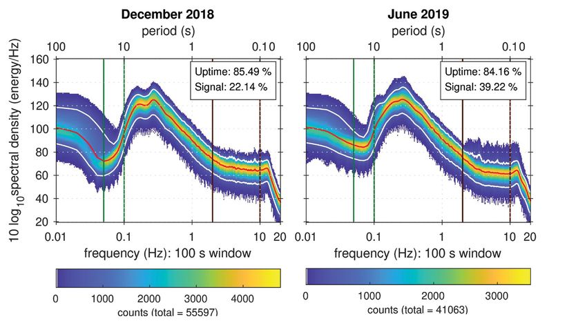
not drift). Instead of measuring ground displacement
directly, hydrophones now listened for ground motion
conversions to acoustic water pressure variations.

 Although these approaches jumpstarted the use of
 hydroacoustics for earthquake seismology, subsurface
 moorings were expensive and surface sonobuoys were
 noisy and had short lifetimes. As a result, the idea of
 having any seismological instrumentation drift with the       Figure 2. Location of last surfacing of the instruments in
 currents at depth, let alone at the surface, was largely      the South Pacific Plume Imaging and Modeling array of
 abandoned. Earthquake signals picked up by newer float        third-generation Mobile Earthquake Recording in Marine
 models incorporating both geophones and hydrophones           Areas by Independent Divers MERMAID instruments, an
 did continue to get reported through the late 1980s, but      international project coordinated by the EarthScope Oceans
 design improvements of ocean-bottom seismometers              consortium (see www.earthscopeoceans.org). The legend
 ultimately took the science of instrumenting oceanic          identifies every instrument’s institutional owner. Image
 areas for global seismology in an altogether different,       courtesy of Jonah N. Rubin.
 and successful, new direction (Suetsugu and Shiobara,
 2014). Semipermanent hydrophone arrays in the oceans
 today continue to play a role in Nuclear Test Ban Treaty Fifty Mermaids
 verification (Bradley and Nichols, 2015), but they do not In the early 2000s, John Orcutt and Jeff Babcock at
 reliably detect earthquake arrivals.                        the Scripps Institution of Oceanography in La Jolla,
                                                             CA, spearheaded the development of a system for
 Nevertheless, the costs of deploying and recovering ocean- “Mobile Earthquake Recording in Marine Areas by
 bottom sensors remain prohibitive, and the vision of a Independent Divers” (MERMAID). They equipped
 long-lived network of easily launched, passively drifting an oceanographic float with a hydrophone recording
 low-cost hydrophones to detect and report distant earth- package, and the first-generation MERMAID was born
 quakes lived on. Guust Nolet, at Princeton University in (Simons et al., 2006).
 New Jersey, carried on building the science case. In the
 decades since the earliest forays, battery technology leapt The development of MERMAID is told starting in
 forward, the Global Positioning System enabled precise First Sound. Spoiler alert! Here’s how this story ends.
 surface location and timing anywhere in the oceans, and Fifty years after Bradner et al.’s (1970) visionary instru-
 satellite communication matured to the point where com- ment, 50 third-generation MERMAIDs, each with a
 mercial systems provided coverage anywhere on Earth, life span of about 5 years, have been launched in the
 allowing for near real-time data transmission.              Pacific, freely drifting at depth but surfacing for data
                                                             transmission and reporting seismograms triggered by
 Ocean-float technology also came of age (Gould, 2005). By earthquake sources around the world, ready for seismo-
 the mid- to late 1990s, the development of freely drifting logical analysis (see Figure 2). A recent modification
 repeatedly diving “profiling” floats brought together the designed to report acoustic spectral densities for the
 oceanographic community into worldwide collaboration. environmental analysis of marine sound is set to debut
 Fast forward, and as of this article, some 4,000 so-called in the Mediterranean this year.
“Argo” floats (see argo.ucsd.edu) are surfacing every 10
 days, collectively returning almost 400 conductivity-tem- A consortium, EarthScope Oceans, now coordinates
 perature-depth profiles per day for oceanographic and autonomous midwater robotic seismometry worldwide
 climatological research. Additionally, novel biological while hatching ambitious plans for other applications of
 and geochemical sensors (Riser et al., 2018) have vastly hydroacoustics and ocean observation writ large. Here,
 widened the range of instrumental capabilities compared we provide a brief history and a current status report and
 with what was originally envisioned.                        share our dreams for the future.

                                                                                     Summer 2021 • Acoustics Today   43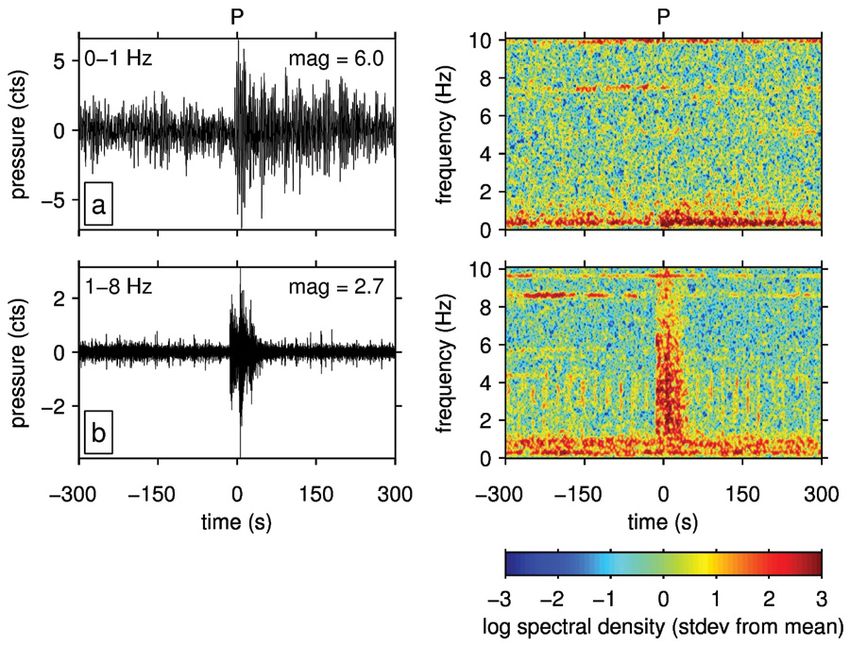
MOBILE EARTHQUAKE RECORDING

Mission Objectives                                           2006). Seismic wave speed maps provide a snapshot of
Mapping the three-dimensional structure inside our the Earth’s interior temperature distribution as it slowly,
planet is key to elucidating the origin of Earth, its subse- but inexorably, cools down overall.
quent evolution, and its ongoing dynamics (Romanowicz,
2008). Information on deep-Earth structure is gleaned Whatever the nature of the seismological probing method,
via seismic wave speed tomography and other advanced the ability to measure small variations in seismic propa-
seismic-imaging techniques (Tromp, 2020) from the gation velocities is crucial. Land-based global networks
transient elastic wavefield emitted by earthquakes that help us map origin times and locations of earthquake
are large enough to be recorded worldwide.                   sources. Seismic waves from distant earthquakes convert
                                                             at the ocean bottom to acoustic pressure variations in
The interior of our planet consists of roughly concentric the water column. On the receiving end, determining
shells named crust, mantle, liquid outer, and crystalline the location of the recording station and keeping track
inner core, but such a one-dimensional subdivision is of time are of fundamental importance. To measure seis-
inadequate. To begin, the crust is very heterogeneous, mic velocities of earthquake arrivals with sensors drifting
broken up into a patchwork of tectonic plates and rang- at depth, we must quickly tag the instrument’s location
ing in thickness from 0 km at midocean ridges to some and time of recording. In practice, this entails surfac-
70 km under the Andes and the Himalayas. Further- ing within days, if not hours, for the Global Positioning
more, the solid mantle slowly moves about, ultimately System location determination and time acquisition to
mixing but maintaining inhomogeneities of temperature, perform instrumental clock-drift corrections and to
chemical composition, and crystal structure. Much like transmit the detected data via satellite.
the crust, the base of the mantle, some 2,891 km down
into the Earth, is also extremely heterogeneous, and the Not all earthquakes are created equal, and to be useful
core-mantle boundary is a “mountainous” surface. Last, for tomographic imaging of the Earth’s mantle, we must
even the solid inner core displays strong contrasts in be judicious in reporting “data” and avoid false triggers.
physical properties, related to its growth by the continued Diving, surfacing, and data transmission are energetically
solidification of the liquid outer core. Its seismic wave costly. Although future generation instruments might
speed varies from place to place, often anisotropically, run on thermal-energy conversion (Jones, 2019), the
that is, depending on the look angle. Taken all together, instruments of today have a finite battery supply.
a multitude of observations shows that the interior of the
Earth manifests significant lateral variations from merely In the end, what we require is an autonomous robotic
depth-dependent structure, which therefore requires oceanic vehicle with a hydrophone that sensitively hears,
three-dimensional mapping.                                   actively listens to, and expediently reports the sounds
                                                             from distant earthquakes. And, to truly conquer the
Different rocks and minerals all have different seismic oceans, we need a large number of them.
wave speeds, but, to a good approximation, seismic wave
speeds in the mantle are primarily a record of its internal First Sound
temperature distribution. Unlike the speed of sound in The first prototype, MERMAID-001, fulfilled the core
air, which increases with temperature, hot rocks transmit requirements of seismological functionality, namely,
sound more slowly. In contrast, when rocks are colder, earthquake detection. Figure 3 shows the design, includ-
their wave speed increases. (For more on the acoustic ing the acoustic payload of an off-the-shelf hydrophone.
properties of rocks, see TenCate and Remillieux, 2019.) Data were stored on a flash memory card.
Because hotter rocks are buoyant and colder rocks are
denser than their surroundings, the mantle slowly con- Over the course of 3 recovered field tests, MERMAID-001
vects, deforming internally. Tomographic images reveal gathered a mere 120 hours of acoustic pressure data from
zones of high seismic wave speed that outline sinking a depth of around 700 m offshore from La Jolla. Several
sheets of subducted material (van der Hilst et al., 1997), positive earthquake identifications stood out from the
while isolated columnar upwellings or mantle plumes noise. One of these was a tremor large enough and dis-
are manifest as low wave speed regions (Montelli et al., tant enough to prove the utility of the new instrument for

44   Acoustics Today • Summer 2021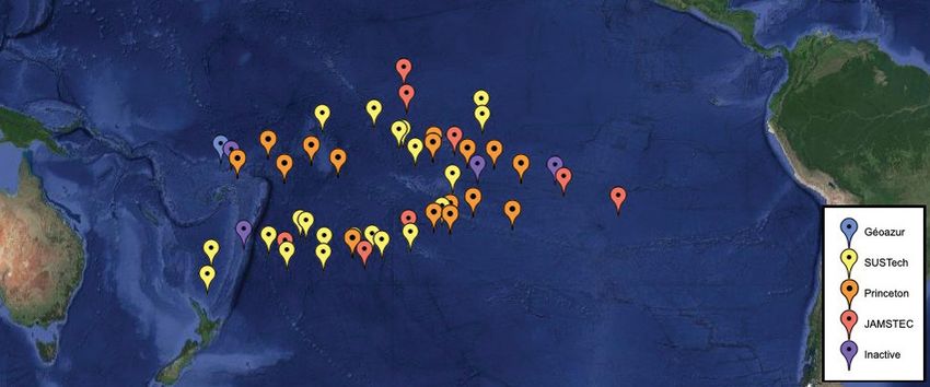
2020), but for the purposes of imaging the deep Earth,
                                                             they are unwanted. Last, the ocean is full of sound (Dahl
                                                             et al., 2007) that also must be filtered out. Examples are
                                                             ship propellers, volcanic eruptions, glacial calving, rain,
                                                             mysterious plane crashes, and, of course, sounds of bio-
                                                             logical origin. Adaptations targeting rather than avoiding
                                                             such sources are straightforward. Acoustic packages tai-
                                                             lor-made for whale census research (Matsumoto et al.,
                                                             2013) and meteorology (Riser et al., 2008) are part of
                                                             MERMAID’s extended family.

                                                             The Second Coming
                                                             MERMAID’s breakthrough came in the form of the second-
                                                             generation model (Hello et al., 2011) that reported data via

                                                              Figure 4. Seismic events detected at a 700 m depth offshore
                                                              of San Diego, CA, during the recovered deployments of
                                                              MERMAID-001. a: Only the large (magnitude [mag] 6) event is
 Figure 3. The first-generation MERMAID prototype: an         from a distant source 5,170 km from the epicenter as measured
 oceanographic profiling float equipped with an externally    along the surface of the Earth and is thereby suited to map
 mounted hydrophone, and a recording and processing unit.     seismic wave speed variations in the Earth’s mantle. b: a nearby
 Reproduced from Simons et al., 2009, with permission.        (144 km epicentral distance) smaller (magnitude 2.7) crustal
                                                              earthquake. Left column: filtered pressure records aligned on
                                                              the first-arriving seismic “P” wave. Right column: Fourier
global seismology (Simons et al., 2009). Several smaller      spectrograms. These reveal how earthquake propagation
magnitude events were, strictly speaking, bycatch and         over long distances filters out the high frequencies. Pressure
not useful for deep-Earth imaging. They are, however,         conversions due to the close-by earthquake remain prominent
suitable for assessments of local and regional seismicity     in the range of 0-10 Hz, whereas the distant quake registers as
and to study crustal structure. The difference in char-       a relatively small blip of power around 0.5 Hz. MERMAID’s
acter between global and local seismicity (Figure 4) is       onboard processing unit recognizes these differences and is now
apparent from the records themselves. Figure 4 shows          tuned to preferentially report large earthquakes. The horizontal
the time-domain records, centered on the arrival of the       bands of energy are caused by nonseismic oceanic acoustic
earthquake’s compressional wave marked “P” for “pri-          noise. Reproduced from Simons et al., 2009, with permission.
mary,” and their Fourier spectrograms.

Every type of earthquake (large or small, deep or shallow,
distant or close-by) has a distinct acoustic fingerprint.
Efficient signal-processing techniques onboard MER-
MAID reduce the streaming time-domain samples to
an evolving “bar code” whose character reveals which
records are due to the types of waves most useful for
whole-Earth wave speed imaging. Acoustic “T” waves
from very shallow sources, for example, carry over long
distances, bouncing around in the Sound Fixing and
Ranging (SOFAR) low-velocity channel of the ocean
itself. Recently, these have been used for water thermom-
etry over long spatial and temporal baselines (Wu et al.,

                                                                                       Summer 2021 • Acoustics Today         45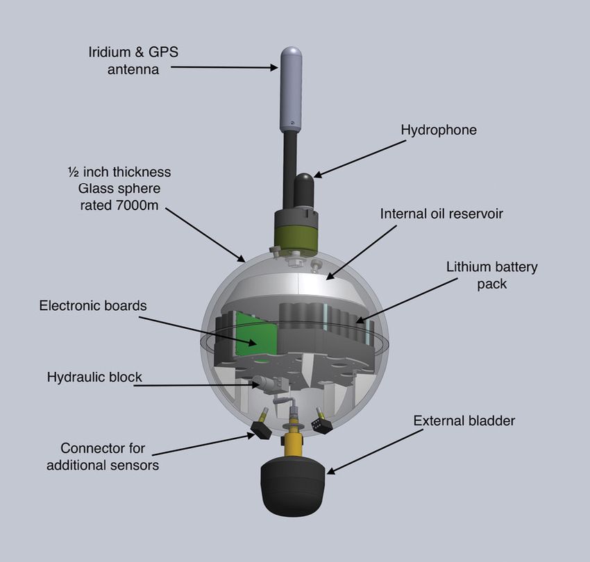
MOBILE EARTHQUAKE RECORDING

satellite in near real time. That all-important autonomy       volcanic hot spot. For two years, nine floats sampled
enabled a series of science deployments. Signal-processing     seismic ray paths that illuminated mantle corridors that
algorithms for sound decision making again proved to be        had never before been accessed directly. Tomographic
critically important. Detection and discrimination routines    modeling of the new data combined with data from land
became probabilistic (Sukhovich et al., 2011) such that        stations revealed that the Galápagos archipelago is under-
MERMAID now has an evaluation and scoring system that          lain by a deep-seated mantle plume, with rocks buoyed
confidently picks out segments of seismological interest and   up by excess temperature carrying an unexpectedly large
reports them to the receiving data centers.                    heat flux toward the surface (Nolet et al., 2019). Those
                                                               are the types of findings that MERMAID was designed to
In this context, one often wonders whether MERMAID             enable, that is, provocative new observations from previ-
technology could be useful for tsunami warning. The            ously inaccessible areas, leading to models that stimulate
ascent from MERMAID’s current parking depth of                 further thinking by the geophysical community.
1,500 m takes a few hours. Such a delay is immaterial for
global earthquake seismology, but the instrument would         In making the 10-year leap from prototype to scientific
need to wait even longer before surfacing until a tsunami      workhorse, the low-cost and nimble MERMAID instru-
can be confidently detected, which it would need to do at      ment became a vital partner in the seismic exploration of
even lower frequencies than is now typical for earthquake      the Earth’s deep interior. Freely drifting midwater hydro-
recording (Joubert et al., 2015). Alternatively, MERMAID       phones fit in an Earth-observing strategy that must also
could be programmed to dive at a shallower depth or reen-      contain increased ocean-bottom sensor coverage among
gineered to rise to the surface faster. However, because       permanent networks of (is)land-based sensors and possi-
tsunami waves caused by an earthquake in, for example,         bly even more exotic types of data gathering (e.g., Sladen
Chile, reach Tahiti, Hawaii, and Japan about 10, 15, and       et al., 2019). Autonomous hydrophones will not replace
22 hours, respectively, after the main event, Masayuki         ocean-bottom seismometers as the backbone of an ocean-
Obayashi from the Japan Agency for Marine-Earth Science        wide observing system, at least in the foreseeable future.
and Technology (Yokosuka) calculates that there may well       But although global arrays of three-component ocean-
be an opportunity for a worldwide array of MERMAID             bottom sensors remain dreams of the future, MERMAID
floats to fulfill this important societal function.            rules in the ocean today.

Across the Mediterranean Sea, the Indian Ocean, and            Third Is the Charm
the Pacific, second-generation MERMAID established             Yann Hello at Géoazur in Valbonne, France, and a team
itself as a reliable purveyor of signals from earthquakes      at French engineering firm OSEAN SAS in Le Pradet,
large and small. Although noise environments vary vastly       France, solved the last of the sticking points, longevity.
among oceans and with the seasons, a large fraction of         Although data returns are variable depending on seis-
global earthquakes with magnitudes greater than 6.5 can        micity, MERMAID’s life expectancy is now five years.
be recorded, as can many smaller ones (Sukhovich et al.,       Moreover, at every surfacing, MERMAID not only
2015). For example, over the course of one month in            transmits seismograms but also takes instructions, for
2013, one of the floats unexpectedly reported hundreds         example, to update mission parameters or tweak filter
of small earthquakes following a magnitude 5.1 shock           settings. A glass sphere now encapsulates the batteries,
in the Indian Ocean. Even the closest island stations          electronics, and hydraulic components to achieve neutral
recorded only a handful of the largest ones, all within        buoyancy in the water column (Figure 5). On its first
a brief interval after the main shock. Hence, although         day-long deployment out of Kobe, Japan, a third-gen-
mantle seismologists continue to focus on large and dis-       eration MERMAID was again so lucky as to catch a first
tant earthquakes, scientists interested in the oceanic crust   earthquake, which arrived in the form of a local mag-
will find MERMAID perfectly capable of being optimized         nitude 5.2 event, dutifully reported over the IRIDIUM
for the study of smaller earthquakes near the instrument.      satellite network.

MERMAID’s first coordinated scientific experiment was          In the current commercial version, MERMAID can
dedicated to imaging the mantle roots of the Galápagos         maintain acoustic operability down to about 3,000 m.

46   Acoustics Today • Summer 2021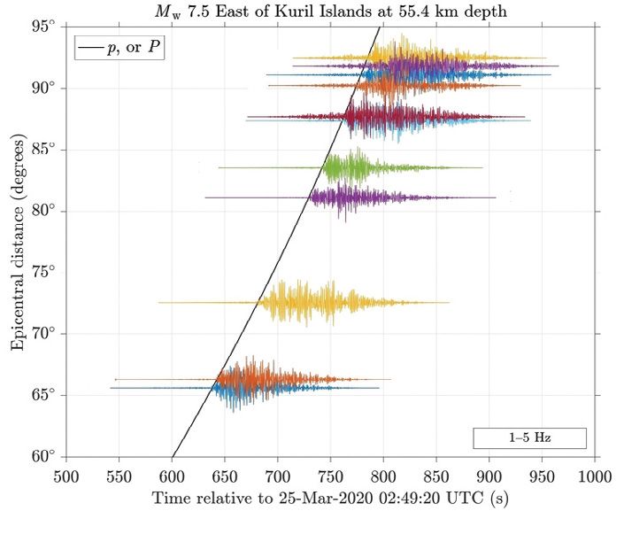
We have arrived at the point where acoustics ends and
                                                              seismology begins. The analysis pipeline (Simon et al.,
                                                              2020), focuses on matching the seismograms reported
                                                              by MERMAID to known earthquakes such that seismic
                                                              wave speeds can be measured. Figure 7 shows seis-
                                                              mograms from two distant earthquakes recorded in
                                                              the Pacific. The solid travel-time curve is a prediction,
                                                              based on a reference Earth model that contains only
                                                              depth-based subdivisions of wave speed and no lateral
                                                              variations. The seismic waves arrive around the predicted
                                                              times, but the signal of the three-dimensional Earth with
                                                              its internal wave speed variations lies in precisely how
                                                              closely these measurements agree with the predictions.
                                                              Seconds matter!

                                                              One Year of Noise
                                                             MERMAID is a low-cost solution to instrumenting the
  Figure 5. Design schematic of the third-generation MERMAID oceans for seismology, most of all because deployment is
  float. Image courtesy of Yann Hello and OSEAN SAS.         extremely straightforward. No specialized equipment or
                                                             personnel is required, and recovery is possible but not man-
                                                             datory if it is not cost effective. Hours after deployment at
Future versions will sustain performance to full-ocean sea, the data files start accumulating on the scientists’ desk-
depths and may be equipped with “landing” capabilities top computers. A running buffer of one year is maintained,
such that MERMAID can become a temporary ocean- and, thanks to two-way communication capability, requests
bottom hydrophone. This will allow some researchers
to shift their focus from the global recording of distant
earthquakes to monitoring local and regional events and        Figure 6. Launch of a MERMAID in the waters around
listening for landslides, cracking glaciers (Deane et al.,    Tahiti. No specialized equipment is needed. Once waterborne,
2019), and other nonseismic signals.                          MERMAID is completely autonomous and reports earthquake
                                                               records via satellite, on average every 6.25 days. Photograph
Five Years                                                     courtesy of Frederik J. Simons.
With Yongshun John Chen and his team from SUSTECH
in Shenzhen, China, in the lead, the French, Japanese,
and US partners joined forces. Their attention has turned
to the volcanic islands of Polynesia including Tahiti,
Samoa, and Marquesas among many others. What lies
beneath them? A broad region of anomalously slow-wave
velocities in the mantle deep under the South Pacific
may feed these volcanoes via conduits of hot uprising
rock that may stretch all the way from the core-mantle
boundary to the surface (French and Romanowicz, 2015).
High-resolution tomography is needed to understand the
fine-scale nature of this planetary hot-rock plumbing
system. The 50 MERMAIDs launched so far (Figure 6)
will give scientists the large-aperture array necessary to
perform detailed imaging at depth.

                                                                                       Summer 2021 • Acoustics Today       47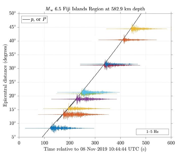
MOBILE EARTHQUAKE RECORDING

 Figure 7. Seismograms reported by MERMAIDs in the Pacific. Graphs correspond to two different earthquakes, identified by the
 titles. Mw is a measure of earthquake magnitude. The time (in seconds), is since the earthquakes’ origin time. The source-receiver,
 or epicentral, distance, is measured in decimal degrees. Every degree is about 111 km measured along the surface of the Earth. The
 seismograms are drawn centered at the distance between the earthquakes’ epicenter and the individual MERMAIDs, which are
 distinguished by arbitrary colors. The acoustic pressure records are scaled to show only relative differences in amplitude. Slanted
 lines: predictions (p or P) for when the seismoacoustic compressional waves from the earthquakes should arrive, made in simple
 reference Earth models. Lowercase p waves travel up from the earthquake; uppercase P waves propagate down into the Earth before
 curving back to the surface. When the seismic waves arrive later than predicted, as they do in this region, the mantle through which
 they propagate before conversion to acoustic pressure at the ocean bottom is slow and, by inference, hot, which is in line with the
 idea that deep zones of buoyant material feed the abundant volcanoes in this area of the Pacific.

 Figure 8. Distribution of energy per frequency interval, or spectral density, of acoustic noise at a 1,500 m depth in the Pacific as captured
 by MERMAID’s hydrophone. In the months shown, the instrument was turned on for close to 85% of the time (uptime); 22% and 39%,
 respectively, (signal) of the record contained earthquakes and other “signals” that were removed so as to leave only the ambient “noise”
 of the ocean itself. The stored 1-year record was divided in 100-second-long segments whose spectral densities were calculated, and their
 collective distribution is rendered as a color density map. Red curves, median spectral densities for each month, and their white envelope
 marks the 5th and 95th percentiles. Vertical lines, frequency intervals of interest for earthquake (green curve) and hydroacoustic (black
 line at bottom) observations, respectively. Seasonality is most apparent in the frequency range of 0.08-0.8 Hz and can be clearly linked
 to a mechanism whereby wind-generated surface water waves couple to acoustic waves at double the driving frequency. Newly modified
 MERMAIDs will specifically target and report these sources of ambient noise for studies of the marine environment.

48   Acoustics Today • Summer 2021
can be made to complement and extend the triggered and       efforts worldwide. It intends to shepherd projects into the
automatically reported datasets.                             international arena where globally relevant, and mutu-
                                                             ally agreed upon, decisions can be made on instrument
The spreading out of MERMAID deployments did allow development, science objectives, data management, and
for a unique opportunity. After about one year of continu- outreach activities, much like the land-based seismological
ous operation in the Pacific, one MERMAID was recovered academic community is doing today. Indeed, EarthScope
and its buffer was read out. Access to the continuous time Oceans already deposits data and metadata with the Data
series helps us understand detection sensitivity and eval- Management Center of the Incorporated Research Institu-
uate the performance of the triggering algorithm. The tions for Seismology (IRIS) in Seattle, WA.
complete record includes the first-arriving seismoacoustic
P waves of our primary interest but also later arriving wave The Fourth Generation and the
types such as the purely hydroacoustic, or T, waves. The P Great Beyond
waves mostly travel in the mantle before being converted MERMAID’s fourth generation will carry more than just
to acoustic energy in the ocean. The T waves for the most acoustic sensors, and the instruments will become fully
part travel in the water layer itself, and they are thus not programmable, even reprogrammable, midmission. The
useful for imaging of the solid Earth.                       computer language developed for this purpose, MeLa
                                                             (Bonnieux et al., 2020), is the bridge between engineers
Excising all those “signals,” we are left with the “noise” worried about hardware constraints, computer scientists
soundscape of the marine environment at 1,500 m depth, specialized in the design of low-power embedded sys-
which enables us to study its seasonal variability. Figure 8 tems, and the multiple end users who will simply want
shows two noise power-spectral densities for different to focus on maximizing scientific data return. Obser-
months. The sensitivity of the hydrophone decreases vation modes will be able to flexibly switch between,
steeply below 0.1 Hz, and, in Figure 8, filtering has for example, earthquake observation, noise record-
removed the signal above 10 Hz. The very low frequency ing, whale call identification, and profiles of salinity or
(VLF) acoustics band above 5 Hz largely contains human- biogeochemical measurements. A mobile app, Adopt-A-
made noise, mainly from shipping. The broad peak of Float, exists to animate classroom outreach activities. By
power is caused by wind and wave action at the ocean including seismologists and acousticians, biologists and
surface. Such noise is also observed at the ocean floor bioacousticians, physical and chemical oceanographers,
and even through reverse conversion of acoustic pressure meteorologists and climate scientists, and others, Earth-
to elastic waves on distant land stations. It constitutes Scope Oceans will become even more multidisciplinary.
the dominant “secondary microseismic” noise contribu- Collaboration with other ocean-observing programs will
tion that Bradner set out to observe in situ back in the enable cost-effective instrument deployment and oppor-
1970s. We have come full circle. A group of MERMAIDs tunistic recovery by nonspecialized vessels, such as cruise
modified to report ambient noise spectra rather than ships or pleasure yachts.
earthquake signals was commissioned by Lucia Gualtieri
at Stanford University (Stanford, CA) for deployment in In the years to come, MERMAID will carry more
the Mediterranean and the Atlantic in the year to come. instrumental payload, dive deeper, travel farther, and
                                                             live longer. Many hands (on few decks) will make light
United We Dive: EarthScope Oceans                            work. Consider yourselves invited to join the commu-
The MERMAID project evolved from a single proto- nity. Sound, after all, is an Essential Ocean Variable (see
type to a fledgling fleet of promising newcomers to a acousticstoday.org/ocean-soundscapes).
now 50-strong array of robust third-generation units
with a lifetime of 5 years that is currently floating about, Acknowledgments
collecting acoustic data for seismological science. The We owe a debt of gratitude to the editor, Arthur N. Popper,
story of how we got there is one of selfless collabora- whose tireless advocacy on behalf of the readers of Acous-
tion across generations, between individuals, institutions, tics Today helped us immeasurably to improve the writing
and nations. The EarthScope Oceans consortium (see and presentation of this article. We also thank Micheal
www.earthscopeoceans.org) was founded to coordinate Dent and Helen A. Popper for numerous constructive edits.

                                                                                    Summer 2021 • Acoustics Today   49
MOBILE EARTHQUAKE RECORDING

References                                                                          Simons, F. J., Nolet, G., Babcock, J. M., Davis, R. E., and Orcutt, J. A., (2006). A
Bonnieux, S., Cazau, D., Mosser, S., Blay-Fornarino, M., Hello, Y., and Nolet, G.    future for drifting seismic networks. Eos, Transactions American Geophysi-
 (2020). MeLa: A programming language for a new multidisciplinary oceano-            cal Union 87(31), 305-307. https://doi.org/10.1029/2006EO310002.
 graphic float. Sensors 20(21), 6081. https://doi.org/10.3390/s20216081.            Simons, F. J., Nolet, G., Georgief, P., Babcock, J. M., Regier, L. A., and
Bradley, D. L., and Nichols, S. M. (2015). Worldwide low-frequency                   Davis, R. E. (2009). On the potential of recording earthquakes for
 ambient noise. Acoustics Today 11(1), 20-26.                                        global seismic tomography by low-cost autonomous instruments
Bradner, H., de Jerphanion, L. G., and Langlois, R. (1970). Ocean
                                                                                     in the oceans. Journal of Geophysical Research: Solid Earth 114(85),
 microseism measurements with a neutral buoyancy free-floating
                                                                                     B05307. https://doi.org/10.1029/2008JB006088.
 midwater seismometer. Bulletin of the Seismological Society of Amer-
                                                                                    Sladen, A., Rivet, D., Ampuero, J. P., Barros, L. D., Hello, Y., Calbris,
 ica 60, 1139-1150.
Dahl, P. H., Miller, J., Cato, D. H., and Andrew, R. K. (2007). Under-               G., and Lamare, P. (2019). Distributed sensing of earthquakes and
 water ambient noise. Acoustics Today 3(1), 23-33.                                   ocean-solid Earth interactions on seafloor telecom cables. Nature Com-
Deane, G. B., Glowacki, O., Stokes, M. D., and Pettit, E. C. (2019).                 munications 10, 5777. https://doi.org/10.1038/s41467-019-13793-z.
 The underwater sounds of glaciers. Acoustics Today 15(4), 12-19.                   Suetsugu, D., and Shiobara, H. (2014). Broadband ocean-bottom seis-
 https://doi.org/10.1121/AT.2019.15.4.12.                                            mology. Annual Review of Earth and Planetary Sciences 42, 27-43.
French, S. W., and Romanowicz, B. (2015). Broad plumes rooted at                     https://doi.org/10.1146/annurev-earth-060313-054818.
 the base of the Earth’s mantle beneath major hotspots. Nature 525,                 Sukhovich, A., Bonnieux, S., Hello, Y., Irisson, J.-O., Simons, F. J., and Nolet,
 95-99. https://doi.org/10.1038/nature14876.                                         G. (2015). Seismic monitoring in the oceans by autonomous floats. Nature
Gould, W. J. (2005). From Swallow floats to Argo — The development of                Communications 6, 8027. https://doi.org/10.1038/ncomms9027.
 neutrally buoyant floats. Deep Sea Research Part II: Topical Studies in Ocean-     Sukhovich, A., Irisson, J.-O., Simons, F. J., Ogé, A., Hello, Y., Des-
 ography 52(3-4), 529-543. https://doi.org/10.1016/j.dsr2.2004.12.005.               champs, A., and Nolet, G. (2011). Automatic discrimination of
Hello, Y., Ogé, A., Sukhovich, A., and Nolet, G. (2011). Modern mer-
                                                                                     underwater acoustic signals generated by teleseismic P-waves: A
 maids: New floats image the deep Earth. Eos, Transactions American
                                                                                     probabilistic approach. Geophysical Research Letters 38(18), L18605.
 Geophysical Union 92(40), 337-338.
                                                                                     https://doi.org/10.1029/2011GL048474.
 https://doi.org/10.1029/2011EO400001.
Jones, J. A., Chao, Y., Fratantoni, D. M., Zedelmair, M. M., Willis, R.             TenCate, J. A., and Remillieux, M. (2019). The peculiar acoustics of rocks.
 E., and Leland, R. S. (2019). Environmental Thermal Energy Conver-                  Acoustics Today 15(2), 29-35. https://doi.org/10.1121/AT.2019.15.2.29.
 sion. US Patent No. 10,443,581, October 15, 2019. Available at                     Tromp, J. (2020). Seismic wavefield imaging of Earth’s interior across
 https://seatrec.com/wp-content/uploads/2020/08/seatrecUS10443581B2-.pdf.            scales. Nature Reviews Earth & Environment 1, 40-53.
Joubert, C., Nolet, G., Sukhovich, A., Ogé, A., Argentino, J. F., and                https://doi.org/10.1038/s43017-019-0003-8.
 Hello, Y. (2015). Hydrophone calibration at very low frequencies.                  van der Hilst, R. D., Widiyantoro, S., and Engdahl, E. R. (1997). Evi-
 Bulletin of the Seismological Society of America 105(3), 1797-1802.                 dence for deep mantle circulation from global tomography. Nature
 https://doi.org/10.1785/0120140265.                                                 386, 578-584. https://doi.org/10.1038/386578a0.
Matsumoto, H., Jones, C., Klinck, H., Mellinger, D. K., Dziak, R. P.,               Wu, W., Zhan, Z., Peng, S., Ni, S., and Callies, J. (2020). Seismic ocean thermome-
 and Meinig, C. (2013). Tracking beaked whales with a passive acous-                 try. Science 369(6510), 1510-1515. https://doi.org/10.1126/science.abb9519.
 tic profiler float. The Journal of the Acoustical Society of America
 133(2), 731-740. https://doi.org/10.1121/1.4773260.
Montelli, R., Nolet, G., Dahlen, F. A., and Masters, G. (2006). A cata-
                                                                                       About the Authors
 logue of deep mantle plumes: New results from finite-frequency
 tomography. Geochemistry, Geophysics, Geosystems 7(11), Q11007.
 https://doi.org/10.1029/2006GC001248.                                                                           Frederik J. Simons
Nolet, G., Hello, Y., van der Lee, S., Bonnieux, S., Ruiz, M. C., Pazmino,                                       fjsimons@alum.mit.edu
 N. A., Deschamps, A., Regnier, M. M., Font, Y., Chen, Y. J., and
 Simons, F. J. (2019). Imaging the Galápagos mantle plume with                                                   Department of Geosciences
 an unconventional application of floating seismometers. Scientific                                              Guyot Hall
                                                                                                                 Princeton, New Jersey 08540, USA
 Reports 9, 1-12. https://doi.org/10.1038/s41598-018-36835-w.
Riser, S. C., Nystuen, J., and Rogers, A. (2008). Monsoon effects in the                                    Frederik J. Simons is a geophysicist
 Bay of Bengal inferred from profiling float-based measurements of                                          at Princeton University (Princeton,
 wind speed and rainfall. Limnology and Oceanography 53(5), 2080-                     NJ), interested in the seismic, mechanical, thermal, and
 2093. https://doi.org/10.4319/lo.2008.53.5_part_2.2080.                              magnetic properties of Earth and the terrestrial planets. He
Riser, S. C., Swift, D., and Drucker, R. (2018). Profiling floats in                  earned bachelor’s and master’s degrees in geology from KU
 SOCCOM: Technical capabilities for studying the Southern Ocean.                      Leuven (Leuven, Belgium), and a PhD in seismology from MIT
 Journal of Geophysical Research 123(6), 4055-4073.                                   (Cambridge, MA). He enjoys analyzing complex, large, and het-
 https://doi.org/10.1002/2017JC013419.                                                erogeneous geophysical datasets and designs mathematical
Romanowicz, B. (2008). Using seismic waves to image Earth’s struc-                    and computational inverse methods, and statistical techniques
 ture. Nature 451, 266-268. https://doi.org/10.1038/nature06583.                      to do so. No amount of sophistication can cure a fundamental
Simon, J. D., Simons, F. J., and Nolet, G. (2020). Multiscale estimation              data limitation; hence his involvement in developing floating
 of event arrival times and their uncertainties in hydroacoustic records              hydrophones to open up the sparsely instrumented oceanic
 from autonomous oceanic floats. Bulletin of the Seismological Society                domains for global seismic tomography.
 of America 110(3), 970-997. https://doi.org/10.1785/0120190173.

50    Acoustics Today • Summer 2021
Joel D. Simon                                                     Sirawich Pipatprathanporn
                     jdsimon@alumni.princeton.edu                                      sirawich@princeton.edu
                     Department of Geosciences                                         Department of Geosciences
                     Guyot Hall                                                        Guyot Hall
                     Princeton, New Jersey 08540, USA                                  Princeton, New Jersey 08540, USA
                      Joel D. Simon is a postdoctoral                                  Sirawich “Pete” Pipatprathanporn
                      researcher in the Department of Geo-                             is a PhD student in the Princeton
sciences, Princeton University (Princeton, NJ), where he also      University (Princeton, NJ) Geosciences Department. He
received his PhD in geophysics in 2020. He is a member of the      holds a Bachelor of Science degree in earth and environ-
Standing Committee on Data for the international consortium        mental sciences and interdisciplinary physics from the
EarthScope Oceans (see www.earthscopeoceans.org), which            University of Michigan (Ann Arbor). His research focuses
oversees a drifting array of 50 MERMAID floats. His research       on seismology, with a particular interest in using drifting
pairs hydroacoustics with global seismology to address ques-       hydrophones to detect earthquakes worldwide.
tions concerning the structure of the Earth. He is particularly
interested in signal-processing techniques useful to extract
signals from noisy time series.

     Book Announcement | ASA Press
     ASA Press is a meritorious imprint of the Acoustical Society of America in collaboration with Springer
     International Publishing. All new books that are published with the ASA Press imprint will be announced
     in Acoustics Today. Individuals who have ideas for books should feel free to contact the ASA Publications
     Office, ASAPublications@acousticalsociety.org, to discuss their ideas.

                        Understanding Acoustics:
                        An Experimentalist’s View of Sound and Vibration
                        Author: Steven L. Garrett

     This open access textbook, like Rayleigh’s classic           wave propagation that can accommodate dissipa-
     Theory of Sound, focuses on experiments and on               tive mechanisms and geometrically-complex media.
     approximation techniques rather than mathemati-              Fundamental principles that do not ordinarily
     cal rigor. The second edition has benefited from             appear in other acoustics textbooks, like adiabatic
     comments provided by many acousticians who                   invariance, similitude, the Kramers-Kronig rela-
     have used the first edition in undergraduate and             tions, and the equipartition theorem, are shown to
     graduate courses. A uniform methodology is pre-              provide independent tests of results obtained from
     sented for analysis of lumped-element systems and            experiments and numerical solutions.

                                                Find out more at
                                   www.springer.com/gp/book/9783030447861

                                                                                          Summer 2021 • Acoustics Today      51
You can also read