U.S. community perspectives on coastal flooding
←
→
Page content transcription
If your browser does not render page correctly, please read the page content below
AN ASBPA WHITE PAPER:
U.S. community perspectives on coastal flooding
By
Science & Technology Committee
Nicole Elko, Tiffany R. Briggs,2 Reza Marsooli,3 Patrick Barrineau,4 Cheryl Hapke,5
1
Kimberly McKenna,6 Jonathan Simm,7 Marc Beyeler,8 Matt Smith,9 and Cary Troy10
1) ASBPA, P.O. Box 1451, Folly Beach, SC 29439; nicole.elko@asbpa.org
2) Florida Atlantic University, Department of Geosciences, 777 Glades Road, SE470, Boca Raton, FL 33431
3) Stevens Institute of Technology, Castle Point Terrace, 223 ABS Engineering Center, Hoboken, NJ 07030
4) Coastal Science & Engineering, 160 Gills Creek Parkway, Columbia, SC 29205
5) Integral Consulting Inc., 200 2nd Avenue South #155, St. Petersburg, FL 33701
6) Stockton University Coastal Research Center, 30 Wilson Ave., Port Republic, NJ 08241
7) HR Wallingford, Howbery Park, Wallingford, OX10 8BA, United Kingdom
8) BEACON, 26416 Mulholland Highway, Calabasas, CA 93102
9) U.S. Army Corps of Engineers, Institute for Water Resources, 7701 Telegraph Road (Casey Building), Alexandria, VA 22315
10) Lyles School of Civil Engineering, Purdue University, 550 Stadium Mall Drive, West Lafayette, IN 47907-2051
ABSTRACT respondents indicated that flooding was a major challenge,
Coastal flooding, from both extreme events and sea level rise, only 24% of respondents’ communities have a coastal flooding
is one of the top management challenges facing U.S. coastal adaptation plan. Improvements to drainage systems are the
stakeholders today. The intensity of coastal flooding is expected most commonly implemented gray infrastructure strategy in the
to increase with global sea level rise. This paper focuses on Southeast and Gulf coast regions. Respondents from all regions
flooding challenges from the perspective of coastal communi- noted that beach and dune restoration has been the most widely
ties. The myriad of flood mitigation strategies that have been implemented nature-based flood mitigation strategy. Interest is
implemented across the U.S. vary based on a multitude of factors now high in other nature-based solutions with application in
including spatio-temporal scale of the coastal flooding hazard. low-lying, vulnerable coastal areas such as thin-layer placement
ASBPA administered a survey of 106 coastal stakeholders on marshes, living shorelines, and hybrid projects on estuarine
from around the U.S. to assess specific community challenges shorelines. This paper does not provide an exhaustive review
and needs related to coastal flooding in late 2021. A majority of the science, forcings, or policies on coastal flooding in the
of respondents indicated that their community includes an U.S.; rather, it captures the perspectives of coastal communities
underserved population or neighborhood (54%) or nearby and aims to inform and prioritize future research investments
communities do (25%). While the vast majority of survey related to coastal flooding.
T
he American Shore and Beach • Coastal flooding, both: sea level rise Flooding commonly occurs in coastal
Preservation Association (ASB- and associated flooding (e.g. nuisance areas of the United States as a result of
PA) has polled coastal stakehold- flooding, King tides); and combined ef- astronomical tides, storm surge, wave
ers (i.e. practitioners) to identify their top fects of rainfall and surge on urban flood- overtopping, local winds, and/or seich-
coastal management challenges (Elko and ing (i.e. episodic, short-term), as well as ing. Coastal flooding induced by storm
Briggs 2020). Informed by two annual flooding from changes in lake levels along surge and waves is primarily caused by
surveys, a multiple-choice online poll was the Great Lakes coastline, severe wind events including extratropi-
conducted in 2019 to evaluate stakehold- cal and tropical cyclones, cold fronts, and
• Chronic beach erosion (i.e. high/
ers’ most pressing problems and needs, long-period swells. In addition to storms,
increasing long-term erosion rates), and
including what they felt most ill-equipped tsunamis and tectonic activity can cause
to deal with in their day-to-day duties and • Coastal water quality, including coastal flooding in Hawaii, Alaska, and
which tools they most need to address harmful algal blooms (e.g. red tide, Sar- the West Coast. Along some estuaries and
these challenges. Overall, the prioritized gassum). particularly the Great Lakes shorelines,
coastal management challenges identified flooding may be triggered by seiches or
The goal of this paper is to address
by the survey were: meteotsunamis formed by winds from
some of the issues surrounding the man- certain directions and/or magnitudes.
• Deteriorating ecosystems leading to agement challenge of coastal flooding, Such flooding is exacerbated by sea level
reduced (environmental, recreational, and to share challenges that coastal com- rise as waves and storm surges can pen-
economic, storm buffer) functionality, munities face with regards to flooding. etrate through the coastal zone and have
The information provided may be helpful
• Increasing storminess due to climate extended impacts inland.
in prioritizing research investments in
change (i.e. more frequent and intense
the topic area. Highly localized coastal flooding
impacts),
events are often referred to as nuisance
Shore & Beach Vol. 90, No. 3 Summer 2022 Page 17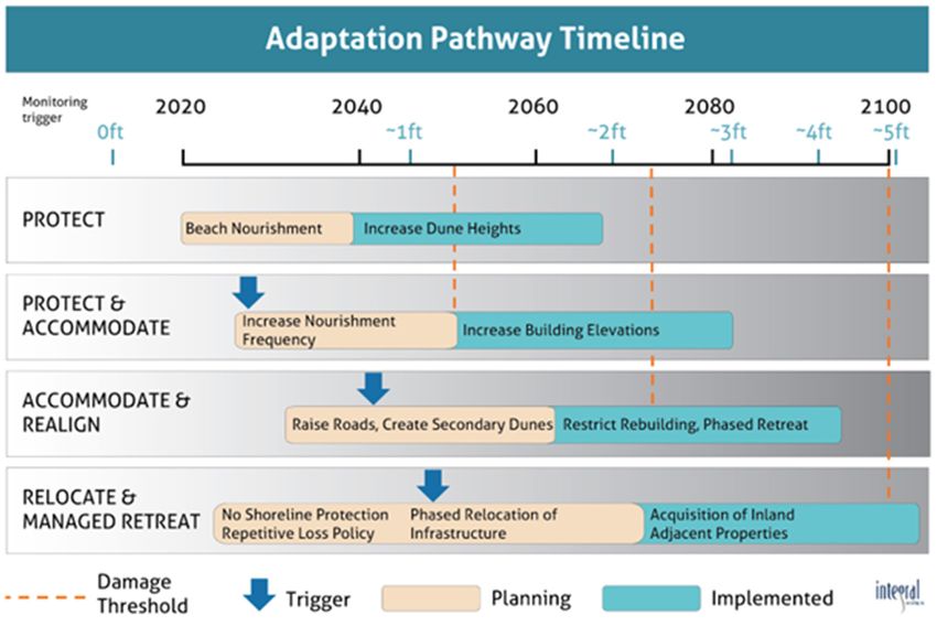
Figure 1. Median (50th percentile) projection of local sea-level rise (meter) at the location of tide gauges. Projections
are shown for the end of 21st century under the high emission, fossil-fueled development scenario “Shared Socio-
economic Pathway 5-8.5” medium confidence. The figure is generated based on data from the IPCC AR6 (Fox-Kemper
et al. 2021).
flooding, high-tide flooding (Sweet et al. age to infrastructure but in the long-term more commonly in the Great Lakes, with
2018, 2019, 2020, 2021, 2022), or collo- the seawater salinity could lead to costly increasing precipitation and evaporation
quially, King tides, and are all driven by damages to public infrastructure as well competing as offsetting effects (Norton et
increased flooding due to relative sea level as private property. al. 2019; Do et al. 2020; Groenwald et al.
rise (Douglass and Webb 2020). These 2021). For example, Lake Michigan water
Coastal flooding as it relates to sea
terms are sometimes used interchange- levels increased nearly 2 m between 2013
level, described above, is especially no-
ably, but can represent subtle differences and 2020, a range that essentially spans
ticeable along estuarine and ocean-facing
in process and impact. High-tide flooding the entire range of lake levels experienced
coasts, and is influenced by flash flood-
occurs when water levels exceed mean in recorded history, from record low to
ing exacerbated by impervious surfaces,
higher high-water level for a particular record high waters. In addition to caus-
historic stormwater infrastructure that
location (Sweet et al. 2020). Nuisance ing widespread coastal damage from
have become a tidal water flooding de-
flooding generally represents low levels coastal erosion (e.g. Volpano et al. 2020,
livery system, and/or channelization that
of inundation (e.g. 3 to 10 cm depth) that Troy et al. 2021, Theuerkauf et al. 2021),
increase runoff during rainfall events.
disrupt daily activities (Moftakhari et al. prolonged, multi-year high water periods
Impervious surfaces impede infiltration
2018) and includes fluvial, pluvial, and can render low lying Great Lakes coastal
of rainwater into the shallow subsurface,
oceanic flooding. King tides represent areas persistently susceptible to flood-
which increases the residence time for
the highest astronomical tides in a given ing from regularly occurring processes
waters within a particular flooded area.
year (Roman-Rivera and Ellis 2018). Dif- such as large rainfall events, storm surge,
This may hamper rescue and relief efforts
ferences in interpretation and meaning seiches, and meteotsunamis (Melby et al.
during flooding events. Channelization
between these terms may affect mitiga- 2012; Bechle et al. 2016; FEMA, 2014;
of coastal streams leads to higher slopes
tion strategies. While interpretations may Huang et al., 2022).
and velocities within the stream channel,
vary, all describe similar processes; for
which can deliver more water to a par- The combination of heavy rains with
many locations, water levels relative to lo-
ticular storage basin (i.e. flood-protection impervious surfaces and channelized
cal ground elevations are higher now than
impoundments, wetlands, etc.) than that streams has notably exacerbated a num-
in recent history and continue to rise.
system may be able to handle. ber of coastal flood events in recent years.
In contrast to more intense forms of Flooding around the Houston region dur-
The causes and nature of coastal flood-
flooding, high-tide flooding is often not ing Hurricane Harvey was related to inef-
ing in the Great Lakes differs from those
dangerous but can cause public incon- fective drainage systems within a heavily
along ocean coasts. Long-term lake level
veniences due to road closures, over- urbanized landscape (Zhang et al. 2018).
rise has not been shown to be occurring in
whelmed storm drainage systems, and Hurricanes Dorian and Florence led to
the Great Lakes, but water level extremes
contaminated water. High-tide flooding widespread flooding across North Caro-
— both highs and lows — are occurring
does not lead to immediate major dam- lina, particularly in Lumberton where
Page 18 Shore & Beach Vol. 90, No. 3 Summer 2022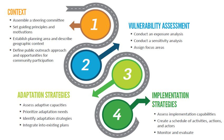
Figure 2. Median (50th percentile) projection of local sea-level rise (meter) at the location of tide gauges in the
Southeast and Mid-Atlantic regions. Projections are shown for the end of 21st century under the high emission,
fossil-fueled development scenario “Shared Socio-economic Pathway 5-8.5” medium confidence. The figure is
generated based on data from the IPCC AR6 (Fox-Kemper et al. 2021).
officials assert Interstate 95 and levees sions by 2100, and three more moderate sea level rise, due to local factors such as
served to funnel floodwaters towards the scenarios. vertical land motion and ocean dynamics
town (see Edwards v. CSX 2020). Across (Figure 1). Overall, regional projections
Each scenario is projected to trigger
the United States, historical development for the United States show that relative
likewise sea level rise. Furthermore,
patterns followed water-borne commerce sea level rise along the West Coast would
each scenario includes a median project
along coasts, estuaries, and rivers. Today, be smaller than the global sea level rise,
sea level rise as well as a range of pos-
many developed areas are especially vul- especially in higher-latitude regions. In
sible values. Diversity and uncertainty
nerable to a suite of flood impacts from contrast, the projected local sea level
inherent in some of the climate models
different sources, different directions, and rise for the East and Gulf Coasts would
used to project warming lead to a range
at different magnitudes. exceed the global sea level rise (Sweet et
of values rather than a single figure for
al. 2022). Along the East Coast, the local
Regional variability each scenario. The median sea level rise
sea level rise for the mid-Atlantic region is
in forcing parameters projections for SSP1-1.19 and 0.38 m by
larger than that for the New England and
The intensity of coastal flooding is 2100, while SSP5-8.5 projects 0.77 m by
Southeast regions (Figure 2). In the Gulf
expected to increase with global sea 2100, compared to a 1995-2014 base-
of Mexico, the local sea level rise along the
level rise (Sweet et al. 2014; Buchanan et line. Accounting for the range of values
northern and western coasts (e.g. Texas
al. 2017; Wang and Marsooli 2021). The within all scenarios, global sea levels are
to Alabama), would exceed that along the
degree to which that occurs is less clear, expected to increase anywhere from 0.28
eastern Gulf Coast (e.g. Florida).
but the IPCC AR6 (Intergovernmental to 1.02 m by 2100.
Panel on Climate Change Sixth Assess- The largest and smallest projections of
Here, as an example to demonstrate
ment Report; Fox-Kemper et al. 2021) local sea level rise in the contiguous Unit-
the regional variability of sea level rise, we
offers more information than previous ed States are, respectively, in the northern
focus on the high emission, fossil-fueled
reports on the probabilities of various fu- region of the Gulf of Mexico and the high-
development scenario “Shared Socio-
ture temperature and sea level scenarios. latitude region of the West Coast. Accord-
economic Pathway 5-8.5” medium-con-
ing to the IPCC AR6, median estimated
The report outlines five main scenarios fidence. Under this pathway, the median
projections of local sea level rise (i.e. the
of future emissions known as “Shared estimated projection of global mean local
level that has 50% chance to be equaled
Socioeconomic Pathways” (SSPs). These sea level rise (i.e. the level that has 50%
or exceeded), are 1.6 m in Louisiana and
include a low-emissions scenario SSP1- chance to be equaled or exceeded) in 2100
0.29 m in Washington by the end of 21st
19, which assumes deep cuts in carbon is 0.77 m, relative to a 1995-2014 baseline.
century relative to a 1995-2014 baseline.
emissions by 2025, a high-emissions sce- Under the same high emission scenario,
Regional sea level rise could differ sub-
nario SSP5-8.5, which assumes continued the largest and smallest projections for
stantially from the projected global mean
increases and a doubling of annual emis-
Shore & Beach Vol. 90, No. 3 Summer 2022 Page 19Table 1. Along the Pacific Coast of the U.S.,
Different categories of adaptation strategies and examples of strategies in “Atmospheric Rivers” (AR), narrow corri-
each category; examples that are considered green are shaded. dors of water vapor transport, contribute
Protection Accommodation Managed relocation
to extreme precipitation and flooding
Beach and Elevate buildings/ Limit expansion (Ralph et al. 2006). For example, on 9
January 2018 a 200-year rainstorm event
dune restoration infrastructure of development
caused massive, locally focused debris
Berm-building Flood-proof buildings/ Limited or no rebuilding flows in creeks and streams in the coastal
infrastructure after disasters community of Montecito, California.
Living shorelines/ Elevate land Property acquisition/ Hundreds of residential, commercial and
Oyster bed restoration and roadways buy-outs community structures were damaged or
Marsh or Increase new Prohibit hard shoreline destroyed and more than 20 lives were
mangrove restoration construction setbacks structures lost (SBCOEM 2021). It is estimated that
well over 1,000,000 cubic yards of debris
Sandbags Increase density of Phased replacement of
inundated public and private properties,
salt-tolerant vegetation hard structures with
and/or flowed to the nearshore ocean
green infrastructure
waters. According to Oakley and Ralph
Seawalls/bulkheads/ (2018): “This (Montecito Debris Flow)
revetments event featured a north-south oriented
atmospheric river with two moisture
Hawaii are, respectively, about 1 m for century, the combined effect of SLR and bands interacting with a closed low pres-
the Island of Hawaii and 0.89 m for TC on flood hazards associated with cli- sure system.”
Kauai. Projections for Alaska show local mate change would result in TC-induced
Goals of this white paper
sea level falling for the southern region, 100-year flood levels to become a 1-year
This white paper aims to share flood-
reflecting tectonic uplift. Local sea level flood level along the New England and
ing challenges that coastal communities
rise is projected for the northern region of mid-Atlantic coasts and a 1-to-30-year
face. The paper does not intend to pro-
Alaska, where a broader coastal plain and flood level along the Southeast Atlantic
vide an exhaustive review of the science,
lack of tectonic activity led to enhanced and Gulf coasts (Marsooli et al. 2019).
forcings, or policies on coastal flooding
flood vulnerabilities (Figure 1).
River and flash floods due to heavy in the U.S.; rather, it aims to capture the
Localized trends calculated specifi- precipitation or snowmelt are other perspectives of coastal communities. A
cally for the United States show a similar types of flooding that frequently occur in broad overview of community impacts,
suite of relationships between RSLR coastal areas. According to the IPCC AR6 perspectives, and select case studies are
between regions, with perhaps a higher (Arias et al. 2021), it is very likely (90%- presented. The methods and results of a
magnitude of change occurring as a result 100% probability) that heavy precipita- survey administered to coastal stakehold-
of vertical land motion and changes to tion events will intensify and become ers are then presented to summarize cur-
oceanic circulation (Sweet et al. 2022). more frequent in the 21st century. Along rent challenges, needs, and recommended
the Gulf and East Coasts, heavy rainfall next steps. The information provided may
In addition to sea level rise, coastal
from TCs has historically resulted in be helpful in prioritizing research invest-
flood hazards are influenced by changes
river and flash flooding as most recently ments in the topic area.
in storm climatology related to global
exemplified by flash floods in New York
warming. Storm surge is a frequent cause Community impacts
and New Jersey caused by heavy rainfall
of major damages along the East and Coastal disasters can result in high
from the remnant of Hurricane Ida in
Gulf Coasts. While storm surge flooding fatalities and economic losses (Newton
2021. This dual-source flooding is called
by extratropical cyclones occurs more and Weichselgartner 2014). Population
compound flooding (Wahl et al. 2015).
frequently, the costliest storm surge flood growth in the coastal zone combined
The amount of TC-induced rainfall is
events have been associated with tropi- with climate-change-induced flooding
inversely proportional to the translation
cal cyclones (TCs). Storm surge hazards is leading to greater impacts to coastal
speed of TCs so that a more severe river/
due to TCs will increase in the coming communities in terms of damage to and
flash flooding could be caused by slow-
decades, given that a warmer climate loss of infrastructure, cultural resources,
moving or stalled TCs (e.g. Hurricanes
will lead to an increase in the intensity and ecosystem function that communi-
Harvey in 2017 and Dorian in 2019).
of TCs (Knutson et al. 2013; Gutmann ties rely on for tourism and recreation.
Historical data suggest that TCs in the
et al. 2018; Knutson et al. 2020) and the These impacts are generally greater in
North Atlantic have become slower (Kos-
frequency of very intense TCs (Knutson more vulnerable communities, which
sin 2018) and more likely to stall near
et al. 2015; Walsh et al. 2016; Sugi et al. tend to exist in places with a history of
the coast (Hall and Kossin 2019), which
2017). These expected changes together disenfranchisement, large low-income
could increase the potential of river and
with the effects of SLR will result in a sub- or minority populations, or in regions
flash flooding. Wahl et al. (2015) found
stantial increase in coastal flood hazards with exceptionally high physical risk and
that changes in the joint distributions of
along the East and Gulf Coasts (Lin et al. lower economic development (Qiang
storm surge and heavy rain events associ-
2012; Marsooli et al. 2019; Marsooli and 2019; Collins et al. 2018). Because SLR
ated with climate change will result in an
Lin 2020). For example, under the high- and climate changes will likely exacer-
increase of flood potential during TCs.
est emission scenario by the end of 21st bate these issues, contemporary studies
Page 20 Shore & Beach Vol. 90, No. 3 Summer 2022on coastal flooding based in the United
States often consider environmental and
social justice components of hazard risk
reduction and other improvements to
resilience (Cutter 2012; Burton and Cut-
ter 2008). These collective properties of
vulnerabilities within certain communi-
ties have been studied in greater detail
over the past few decades than any other
time in modern coastal science, and are
collectively known as social vulnerability
(Stafford and Abramowitz 2017; Collins
et al. 2018; Cutter et al. 2003)
Flood mitigation approaches
Flood mitigation options range from
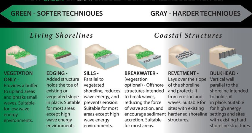
policy and regulatory changes to indi- Figure 3. Adaptation choices can range from green to gray to hybrid, which
vidual adaptation projects to mitigate are combinations from elements of both green and gray approaches (NOAA
impacts from storms and sea level rise 2022b).
(NOAA 2022a). Adaptation strategies munity. An interwoven tapestry of mea- tion strategy that involve USACE and
typically fall into four categories: protec- sures is needed to develop a sustainable state and local managers/sponsors. Over
tion, accommodation, managed reloca- community adaptation plan (Figure 4). 1.5 billion cubic yards of sand have been
tion (or retreat), and do nothing (Table In considering secondary impacts, it is placed along U.S. beaches by both federal
1). Protection involves defense/protec- also important to ensure that adaptation and non-federal entities to reduce beach-
tion actions to mitigate loss of natural strategies are socially equitable and do not front flood risk during the last century
or developed resources (e.g. hard or soft benefit one population to the detriment (Elko et al. 2021). Since 2000 in South
solutions). Accommodation changes to of another, or reinforce existing envi- Carolina, for example, storm surge and
structures, infrastructure, or policies to ronmental and societal inequities. Good tides are not attributed to damages nor
allow for natural hazards to occur while adaptation planning is collaborative and injury nor deaths (Table 2); compared
minimizing their impact. Managed considers the interconnected ecological, with the 1989 landfall of Hurricane Hugo
relocation or retreat either prevents or social, political, and economic systems, which caused 13 impact fatalities (mostly
gradually removes development from the including adjacent jurisdictions. Social drownings) and $8 billion to $10 billion
coast, whereas do nothing is a no action and geomorphological problems can arise in damages (CDC 2022; NOAA 2022c).
approach. Most strategies have varying if disparate shoreline policies (e.g. protect Since the passage of Hugo, there has
long-term adaptive capacity and potential vs. retreat — see below) are adopted be- been a significant federal, state, and local
SLR accommodation (e.g. how flexible is tween neighboring communities. investment in many coastal management
the approach and how much SLR can it policies (mandatory evacuation orders;
FLOOD MITIGATION
accommodate). Adaptation strategies will more robust coastal building codes) and
PROGRAMS AT THE FEDERAL
vary substantially due to the variable land projects (beachfront flood mitigation)
AND STATE LEVELS
uses, coastal typology, exposure to waves, (SC DHEC 2022). These large-scale beach
Several federal and state agencies
erosion potential, and community staff and dune restoration projects are attrib-
have established or funded programs
capacity and funding. uted at least in part to the reduced flood
that address coastal flooding and flood
risk along the South Carolina beachfront
Engineered project-based strategies mitigation strategies (FEMA, NOAA, and
(Kana and Kaczkowski 2019). A similar
can be soft, nature-based, or green (e.g. New Jersey, among others). The programs
national flood risk reduction investment
beach and dune restoration, wetlands, from the U.S. Army Corps of Engineers
is needed on the backside of barrier is-
living shorelines) as opposed to hardened and the Florida Department of Environ-
lands and along estuarine shorelines to
or gray structures (e.g. seawalls, storm mental Protection highlighted emphasize
increase coastal resilience to future sea
barriers) (Figure 3). Hybrid approaches extensive scientific and planning ap-
level rise.
that combine the two are also increas- proaches to reducing flood impacts to
ingly common. Policy changes can also coastal communities. To begin to address this need, USACE
be considered a form of adaptation. The has developed the concept of Engineer-
Example: Federal
intention of adaptation strategies can ing With Nature (EWN) which calls for
The U.S. Army Corps of Engineers
be to restore ecological habitat, mitigate an ecosystem-based approach, whereby
(USACE) has led successful nation-
flooding, and/or manage erosion and USACE, in collaboration with partners
wide efforts to develop comprehensive,
damage to natural resources and public/ and stakeholders, seeks to understand
systems-based approaches to coastal
private property. and use natural processes in order to
flood control for decades. In addition to achieve project objectives within coastal
Adaptation planning evaluates which levees, Coastal Storm Risk Management systems (Bridges et al. 2021; Banks et
measures can be used to alleviate vulner- (CSRM), or federal beach nourishment al. 2013). Historically, institutional con-
ability in each sector and their secondary and dune restoration, projects are an straints, such as the challenges associated
impacts that affect the rest of the com- important nature-based flood mitiga- with interagency coordination, required
Shore & Beach Vol. 90, No. 3 Summer 2022 Page 21Program, intended to comprehensively
prepare both coastal and inland Florida
for the impacts of climate change. As
part of the Resilient Florida Program, a
statewide coastal vulnerability analysis
dataset will be compiled. The community
vulnerability analyses can be undertaken
by individual communities using grant
funding, and are required to follow spe-
cific requirements, including evaluating
the risk to critical assets. The assessments
must evaluate the vulnerabilities at both
the NOAA (2017) intermediate-low and
intermediate-high scenarios and include
two planning horizons, 2040 and 2070.
Select community studies
Many large U.S. cities are investing in
projects focused on improving or install-
ing infrastructure to reduce coastal flood-
Figure 4. Example of an adaptation pathway that is intended to aid coastal ing. Post-Katrina (2005) improvements
communities in long-term planning for adaptation. The pathway lays out a to the New Orleans and South Louisiana
timeline that identifies triggers and thresholds when a change of strategy levee systems cost approximately $14
will be required, giving the communities time to plan in advance (Hapke et al. billion, but only renovated an existing
2021). system. In addition to raising the East
studies for project implementation, and bance scenarios to understand expected River Park in New York City by 8-10
lack of trust between the USACE and performance (Schultz et al. 2012). Most feet, 2.4 miles of seawalls, floodgates, and
relevant stakeholders, may have further projects are designed to provide flexibility other barriers are expected to be con-
constrained the timing and scope of proj- through adaptive management, ensure structed by 2025 along the East River to
ects. However, recent efforts are improv- redundancy of resilient features, and protect Lower Manhattan from scenarios
ing interagency coordination building support creative incentives to promote of catastrophic flooding, such as from
coastal resilience. the use of resilience measures. Hurricane Sandy (2012), with integrated
flood protection for the dense network of
In 2013, the Coastal Engineering Example: State
above- and below-ground infrastructure
Research Board (CERB) recommended The Florida Resilient Coastlines Pro-
and over 110,000 residents of the area
a three-tiered system for an assessment gram (or “Resilient FL”), administered by
(Thomson Reuters 2021). Along the Texas
of the resilience of coastal engineer- the Florida Department of Environmental
coast, a system of levees, flood gates, and
ing, environmental, and community Protection (FDEP) Office of Resilience
improved drainage networks designed by
infrastructure to coastal storms and and Coastal Protection, produced an Ad-
USACE following Hurricane Ike (2008)
long-term evolutionary processes such as aptation Planning Guidebook and a grant
would provide multiple lines of defense
population dynamics and climate change program (FDEP 2018). Communities and
and mimic the models enacted by Loui-
(Larkin et al. 2015; Rosati et al. 2015). regional entities have utilized this process
siana as well as the Netherlands at a price
The tiers include a framework to assess to undertake various stages of adapta-
tag of nearly $30 billion (TXGLO 2022).
overall coastal community resilience, a tion planning, examining vulnerabilities
targeted assessment of the community, and risks associated with flooding from The common thread between these
ecological, and engineered coastal pro- storms, tides and combinations thereof examples is the sheer value of assets ex-
tection structures, and a detailed model (Figure 5). In 2021, the Florida Legislature posed to coastal flooding. For instance,
of interconnected physical infrastructure passed Senate Bill 1954, allocating $1 Miami-Dade County (MDC) is one of the
evaluated under various simulated distur- billion to establish the Resilient Florida most affluent flood-vulnerable jurisdic-
Table 2. tions in the United States (Hanson et al.
Flooding synopsis in South Carolina by type from January 2000 to 2011; Ghanbari et al. 2020). During the
September 2021 (NOAA 2021). 21st century, at least one severe storm
has impacted MDC every two years. As
Property Crop Event type a result, the county has spent more than
Event type Deaths Injuries damage damage count
$326 million for on-site adaptation proj-
Coastal flood 0 0 $450,000 0 56
ects from 2012-2016 (Kim 2020). MDC
Flash flood 22 39 $163,908,390 $24,879,720 470 employs a variety of flood adaptation
Flood 2 1 $37,430,500 $5,009,600 195 approaches spanning from traditional
Storm surge/tide* 0 0 0 0 12 hard “gray” infrastructure (e.g. seawalls,
Total 24 40 $201,788,890 $29,889,320 733 storm barriers) to nature-based or green
*Storm surge statistics may be underrepresented because it is occurring in conjunction with infrastructure (e.g. wetlands, living
other types of flooding and/or because of investment in beachfront flood mitigation.
shorelines), as well as hybrid adaptation
Page 22 Shore & Beach Vol. 90, No. 3 Summer 2022strategies that incorporate both green and
gray features. The City of Miami Beach
plans to invest $500 million in the com-
ing years for sea level rise adaptation that
include raising roads, installing pumps,
and upgrading sewer line connections
(Fu and Song 2017).
A typical coastal flood mitigation
strategy is beach and dune restoration,
which relies on the ability of systems to
protect coastlines from hazards while
also providing benefits such as habitat
enhancement and increased recreational
space, and are more aesthetically pleasing
than hard structures (O’Donnell 2017).
For example, along Hatteras Island, North
Carolina dune restoration projects have
been used to maintain foredune continu-
ity and help reduce overwash frequency Figure 5. Florida’s steps to develop adaptation plans (from FDEP 2018).
and mitigate damages to NC 12 — a
main thoroughfare connecting Cape Hat- issue, horizontal levees (Battalio et al. Some communities are also adapting
teras National Seashore to the mainland 2013) have been designed combining nonstructural solutions to coastal flood-
(Sciaudone et al. 2016). Beach nour- a traditional flood-control levee core ing, such as planning, building codes,
ishment is one of the most commonly with a seaward ecotone slope grading zoning, setback, and buyouts. Since 2015,
implemented soft-adaptation options on smoothly to a low marsh elevation. The when high-tide flooding became a major
the oceanfront, as it adds sediment within slope is planted with native wetland and concern for the City of Folly Beach, this
the littoral system and allows natural transitional species, restoring degraded small South Carolina beachfront com-
forces to continue to operate (Elko et al. habitats while providing adaptive capac- munity adopted six long-term plans
2021). In locations with low to moderate ity to allow wetlands to adjust landward which establish goals and objectives to
rates of beach erosion, nourishment can as sea levels rise. Some designs allow the manage the effects of climate change and
be used to mitigate flooding as well as ecotone slope to undulate slightly, creat- sea level rise. In 2018, the Folly Beach
bolster recreational value of oceanfront ing microhabitats within the slope that City Council approved an unprecedented
shorelines. At Myrtle Beach, South can increase overall habitat diversity. nine-month coastal building morato-
Carolina, a low background erosion rate rium on the development of properties
However, horizontal levees may have
(e.g. < 1 m horizontal shoreline recession on either the beach or the marsh while
limited application in some areas due
per year) means nourishment volumes dune and marsh management plans were
to the larger area required. In the San
can outpace the removal of sand from adopted. This proactive planning process
Francisco Bay area of California, wet-
the active beach-dune system. To this resulted in the adoption of 25 new land
land restoration is of particular interest
point, multiple rounds of nourishment use regulations including ordinances for
given a >90% loss of all wetland areas
completed from the 1980s to present setbacks, buffers, septic tanks, marsh-
largely from development (USGS 2022).
day have advanced the high-water line island development, dune protection,
In consideration of the climate of the
in portions of Myrtle Beach over 50 m seawalls, increased freeboard and other
San Francisco Bay region, many of the
seaward over the same period (Kana and regulations related to increasing resilience
proposed horizontal levees are paired
Kaczkowksi 2019). along the beach and marshfront (Elko
with freshwater discharge points from
2019). Many other coastal communities
California has adopted a number of wastewater treatment facilities. Clean
in South Carolina have also begun the
different strategies to address coastal wastewater is discharged along an infil-
adaptation planning process for antici-
flooding across various environments. tration trench near the top of the slope,
pated future sea level rise-related impacts
For example, wetland restorations are re-establishing the lost freshwater seepage
(Watson et al. 2021).
analogous to beach nourishments in that many wetlands in the region rely on.
that they can reduce flood frequencies Officials in the Montecito community A myriad of strategies is available
and re-establish ecological connectivity in California acknowledge that “the im- and implemented across the U.S. and
within diminished systems. The low-lying pacts of changes in climate and weather can vary based on a multitude of factors
South Bay region is at risk of flooding contributing to extreme rainstorm events including spatio-temporal scale of the
due to sea-level rise, however restoration affecting flooding, need to be taken into coastal flooding hazard. A national-scale
efforts in this region potentially conflict account in multiple plans and planning understanding of perspectives and chal-
with new levee standards that threaten efforts, including coastal hazard mitiga- lenges that coastal communities face due
to further disconnect existing and re- tion, Climate and SLR Adaptation, and to flooding will to help identify gaps in
stored wetlands from natural freshwater regional sediment management plans” knowledge and disseminate information
seepage characteristic of tidal wetlands (Local Government Commission 2019). on potential strategies for communities,
in the region. To combat this potential managers, and stakeholders.
Shore & Beach Vol. 90, No. 3 Summer 2022 Page 23coastal flooding, and details responses to
flood-mitigation strategy implementation
questions.
Surveyed population
Survey participants were asked to
answer several questions to describe
their affiliation, job duties and title, and
region of the U.S. The geographic loca-
tion of survey respondents illustrates the
representation of a national scale survey
with regional perspectives (Figure 6).
The majority of respondents were from
the Southeast (including the Florida east
coast and Puerto Rico, 49%) and the
Gulf (including the Florida Gulf coast,
21%). About 14% were from the U.S. west
coast and Alaska, and 12% were from the
Northeast. A few respondents were also
Figure 6. Geographic distribution of the 106 survey respondents. from Hawaii and the Great Lakes.
Most responses were from industry
and local community representatives
(34% each), followed by the academic
sector (10%) (Figure 7). Federal (8%) and
state (6%) agency staff also represented
13% of respondents. Except in the South-
east region where most participants of
the survey were from local communities
(county, town, homeowners’ assoc.), most
participants from other regions were af-
filiated with industry. Most participants
from the Southeast region self-identified
as administrators or planners; whereas
Program/Project Manager was the most
common job duty in other regions (Fig-
ure 8). Together these characterizations
Figure 7. Affiliations of the survey respondents. suggest a group of survey respondents
SURVEY METHODOLOGY categorize the respondents’ affiliation, that represent coastal practitioners.
In late 2021, ASBPA administered a organization name, title, department, and
A majority of respondents indicated
survey of coastal stakeholders to assess job duties. The next section contained
that their community includes an un-
specific community challenges and needs general questions about coastal flooding
derserved population or neighborhood
related to coastal flooding. The survey challenges. This was followed by a series
(54%) or nearby communities do (25%).
targeted coastal professionals from the of questions as to whether the commu-
Overall, the survey populations’ affilia-
local, regional, state, and federal levels. nities were 1) implementing, or 2) in-
tions, job duties, and region of the U.S.
Respondents included local planners, terested in, flood mitigation approaches
indicate that survey results represent the
managers, engineers, administrators, and described in previous sections, such as
opinions of coastal practitioners on a na-
elected officials, as well as representatives infrastructure, natural or nature-based
tional scale. This basic characterization of
of coastal organizations, consultants, features (NNBF), policies and plans,
the respondents provides the appropriate
and academics with a focus on coastal data and research, and funding solutions.
perspective for the substantive analysis
research. The survey was promoted to Examples of some question phrasing in-
of U.S. communities’ coastal flooding
and taken by members of organizations cluded: “Which of the following natural
challenges.
with a coastal and, more specifically, often or nature-based flood mitigation strate-
beachfront perspective. Traditionally, gies is of interest, but has not yet been Overview of survey responses
for example, the ASBPA has focused on implemented by your community?” In general, survey respondents indi-
beach and shore preservation via beach cated that flooding is either challenging
SURVEY RESULTS
nourishment and dune restoration. (>60%) or extremely challenging (>20%)
The survey yielded 106 total respons-
relative to other coastal management
The first section of the survey aimed es, with the typical respondent complet-
challenges they face. Less than 3% of
to understand respondents’ demograph- ing the survey in 7.5 minutes. This section
respondents indicated that flooding was
ics, organization and job roles and re- characterizes the survey population, re-
not very or not at all challenging. Despite
sponsibilities and included questions to views answers to general questions about
this, only 24% of respondents’ commu-
Page 24 Shore & Beach Vol. 90, No. 3 Summer 2022nities had a coastal flooding adaptation plan, 30% were developing one now, and
water quality, habitat enhancement, and
perhaps even carbon storage.
Large-scale beach and dune restora-
tion projects have reduced flood risk on
a national scale through the placement
of over 1.5 billion cubic yards of sand by
over 465 U.S. beach communities dur-
ing the last century (Elko et al. 2021).
A notable shift in priorities of coastal
communities from beach erosion to
water-related challenges was recorded
in a previous ASBPA survey on coastal
management challenges (Elko and Briggs
2020). A similar and more specific shift
was revealed through the survey con-
ducted with this white paper.
Figure 10. Gray infrastructure flood mitigation strategies of interest to In terms of nature-based strategies,
respondents by region. survey respondents from all regions
selected “beach nourishment and dune
restoration” as the most commonly
implemented green flood mitigation
strategy. Beach nourishment and dune
restoration was the future strategy of
least interest to the survey respondents.
Thin-layer placement on marshes, living
shorelines, and hybrid projects on estua-
rine shorelines were the flood mitigation
strategies of most interest. This shift in
priorities is enlightening given that the
respondents to both surveys are members
of organizations with a focus on beach-
front management. Perhaps the shift
is not surprising given that beachfront
erosion challenges have an accepted and
well-funded mid-term solution in beach
nourishment, and fairly well documented
Figure 11. Nature-based flood mitigation strategies implemented by region.
and recognized co-benefits of recreation,
ing bill), loans from a private banking, of nature-based solutions for flood miti- tourism/economics, and habitat restora-
philanthropic source, or state/federal gation (FEMA 2021). tion in addition to flood mitigation. Until
government (including state revolving recently, flooding challenges in low-lying,
Additional resources for information
funds), and bonds (e.g. environmental non-beachfront coastal areas have not
and funding include (but are not limited
impact bonds, green bonds). yet been prioritized or systematically
to) the National Fish and Wildlife Federa-
addressed with a similar large-scale, repli-
The Federal Emergency Management tion (NFWF) National Coastal Resilience
cable solution that has been implemented
Agency (FEMA) Building Resilient Infra- Fund, State Coastal Programs, Coastal
by hundreds of coastal communities.
structure and Communities (BRIC) is one Zone Management Act Grants, NFWF
of FEMA’s Hazard Mitigation Assistance Great Lakes Fund, U.S. EPA Great Lakes Although a comprehensive analysis
Grants programs. FEMA defines hazard Restoration Initiative Grants, Ecological of the causes of flooding was beyond the
mitigation as any sustainable action that Impacts to Sea Level Rise Grants, the scope of this paper, certain questions
reduces or eliminates long-term risk to 2021 Bipartisan Infrastructure Law need to be addressed to best support com-
people and property from future disasters. (BIL), Community Development Block munities in the development of various
BRIC guiding principles are supporting Grants (CDBG), and Housing and Urban adaptation strategies. For example, what
communities (states, local communities, Development. are the projected futures for existing and
tribes and territories) through capability- new (created or restored) natural and
DISCUSSION
and capacity-building; encouraging and nature-based features? Research and data
The co-benefits that result from
enabling innovation; promoting partner- products that directly inform decision
restoration of marsh or wetland eco-
ships; enabling large projects; maintain- making are critical at all levels. Address-
systems, like flood mitigation as well as
ing flexibility; and providing consistency. ing coastal hazard mitigation, coastal cli-
biodiversity benefits are of great interest
The program provides technical guidance mate change, and sea level rise adaptation
to communities and funding entities.
to local communities to promote the use should be integrated into comprehensive
Some of these benefits include improved
Page 26 Shore & Beach Vol. 90, No. 3 Summer 2022plans for flood mitigation. Furthermore,
communities should adapt strategies
with equity considerations, amplify local
and/or indigenous perspectives into their
plans, and ensure funding is available at
the state and local level with direct techni-
cal assistance to under-resourced coastal
communities.
SUMMARY
Coastal flooding, from both extreme
events and sea level rise, is one of the
top management challenges facing U.S.
coastal stakeholders today. The intensity
of coastal flooding is expected to increase
with global sea level rise with dispro-
portionate impacts likely in vulnerable,
underserved communities. This paper
focuses on flooding challenges from Figure 12. Nature-based flood mitigation strategies of interest by region.
the perspective of coastal communities.
Flood mitigation approaches typically
fall into four categories: protection, ac-
commodation, managed relocation (or
retreat), and do nothing. Options exist
to incorporate green or soft approaches
such as beach or marsh restoration in all
four categories.
Federal- and state-level programs
now exist to increase the resilience of
coastal communities. The myriad of
flood mitigation strategies that have been
implemented across the U.S. vary based
on a multitude of factors including spatio-
temporal scale of the coastal flooding
hazard. A national-scale understand-
ing of perspectives and challenges that
coastal communities face due to flooding Figure 13. Research conducted related to flooding and mitigation strategies.
will help identify gaps in knowledge and Respondents from all regions noted that ing storm intensities, watershed precipi-
disseminate information on potential beach and dune restoration has been the tation and runoff, and increasing coastal
strategies for communities, managers, most widely implemented nature-based wave and run-up forces. Research and
and stakeholders. flood mitigation strategy. Interest is now data products on the nature-based flood
ASBPA administered a survey of 106 high in other nature-based solutions mitigation strategies of greatest interest,
coastal stakeholders from around the U.S. with application in low-lying, vulnerable thin layer placement on marshes, living
to assess specific community challenges coastal areas such as thin-layer placement shorelines, and hybrid projects on estua-
and needs related to coastal flooding on marshes, living shorelines, and hybrid rine shoreline, should be translated and
in late 2021. A majority of respondents projects on estuarine shorelines. disseminated to coastal decision makers.
indicated that their community includes Addressing coastal hazard mitigation,
This paper does not intend to provide
an underserved population or neighbor- coastal climate change, and sea level rise
an exhaustive review of the science, forc-
hood (54%) or nearby communities do adaptation should be integrated into
ings, or policies on coastal flooding in the
(25%). While the vast majority of survey comprehensive plans for equitable flood
U.S.; rather to capture the perspectives of
respondents indicated that flooding was mitigation.
coastal communities and to inform and
a major challenge, only 24% of respon- prioritize future research investments ACKNOWLEDGEMENTS
dents’ communities have a coastal flood- related to coastal flooding. To support We are grateful for helpful reviews
ing adaptation plan. Improvements to communities in the development of ad- from Robert E. Lewis and Pamela Mason,
drainage systems are the most commonly aptation strategies, research is needed to as well as input from the ASBPA Science
implemented gray infrastructure strategy understand, for example, the combined & Technology Committee, and assistance
in the Southeast and Gulf coast regions. water threats and impacts from increas- from Michael Priddy and Annie Mercer.
Shore & Beach Vol. 90, No. 3 Summer 2022 Page 27REFERENCES com/wp-content/uploads/2019/11/Marsh- Huang, C., Anderson, E., Liu, Y., Ma, G., Mann,
Arias, P.A., Bellouin, N., Coppola, E., Jones, R., front-Management-Plan-July-19-FINAL.pdf, G., and P. Xue, 2022. “Evaluating essential
Krinner, G., Marotzke, J., and K. Zickfeld, accessed 7/7/2022. processes and forecast requirements for
2021. “Technical Summary. Contribution of Elko, N., and T.R. Briggs, 2020. “An ASBPA White meteotsunami-induced coastal flooding.”
Working Group I to the Sixth Assessment Paper: National coastal management chal- Natural Hazards, 110(3), 1693-1718.
Report of the Intergovernmental Panel on lenges and needs.” Shore & Beach, 88(4), 34- Kana, T.W., and H.L. Kaczkowski, 2019. “Myrtle
Climate Change,” Climate Change 2021: The 43. https://doi.org/10.34237/1008843. Beach: A history of shore protection and
Physical Science Basis. Masson-Delmotte, V., Elko, N., Briggs, T.R., Benedet, L., Robertson, beach restoration.” Shore & Beach, 87(3),
P. Zhai, A. Pirani, et al. (Eds.) Cambridge W., Thomson, G., Webb, B.M., and K. Gar- 13-34.
University Press. vey, 2021. “A century of U.S. beach nour- Kim, S.K., 2020. “The economic effects of climate
Banks, C.J., Fredette, T.J., Suedel, B.C., and T.S. ishment.” Ocean & Coastal Management, change adaptation measures: Evidence from
Bridges, 2013. “Implementing engineering 199(2021) 105406, ISSN 0964-5691, https:// Miami-Dade County and New York City.”
with nature within the Corps: A workshop.” doi.org/10.1016/j.ocecoaman.2020.105406. Sustainability, 12(3), 1097.
DOER Technical Notes Collection ERDC Federal Emergency Management Agency (FEMA), Knutson, T.R., Sirutis, J.J., Vecchi, G.A., Garner,
TN-DOER-R21. Vicksburg, MS: US Army 2021. “Building Community Resilience with S., Ming, Z., Hyeong-Seog, K., Bender, M.,
Engineer Research and Development Center. Nature-Based Solutions,” https://www.fema. Tuleya, R.E., Held, I.M., and G. Villarini,
http://el.erdc.usace.army.mil/. gov/sites/default/files/documents/fema_risk- 2013. “Dynamical downscaling projections
Battalio B., Holmes, M., and J. Lowe, 2013. “Up or map-nature-based-solutions-guide_2021.pdf, of twenty-first century Atlantic hurricane
out? The laid back levee.” Estuary News 22 (2), accessed 6/14/2022. activity. CMIP3 and CMIP5 model-based
10. https://www.sfestuary.org/wp-content/ Federal Emergency Management Agency (FEMA), scenarios.” J. Climate, 26, 6591-6617.
uploads/2013/03/EstApr2013FINAL-web.pdf. 2014. Great Lakes Coastal Guidelines, Appen- Knutson, T.R., Sirutis, J.J., and Zhao, M., Tuleya,
Bechle, A.J., Wu, C.H., Kristovich, D.A.R., Ander- dix D.3 Update, FEMA Region V, Chicago, IL. R.E., Bender, M., Vecchi, G.A., Villarini, G.,
son, E.J., Schwab, D.J., and A.B. Rabinovich, Florida Department of Environmental Protection and D. Chavas, 2015. “Global projections
2016. “Meteotsunamis in the Laurentian Great (FDEP). 2018. Florida Adaptation Planning of intense tropical cyclone activity for the
Lakes.” Scientific Reports 6, 37832. Guidebook. Florida Resilient Coastlines Pro- late twenty-first century from dynamical
Bridges, T.S., Bourne, E.M., Suedel, B.C., Moynihan, gram, Tallahassee, FL. downscaling of CMIP5/RCP4.5 Scenarios.”
E.B., and J.K. King. 2021. “Engineering With Fox-Kemper, B., Hewitt, H.T., and C. Xiao, Aðal- J. Climate, 28(18), 7203–7224. https://doi.
Nature: An Atlas, Volume 2.” ERDC SR-21-2. geirsdóttir, G., Drijfhout, S.S., Edwards, T.L., org/10.1175/jcli-d-15-0129.1.
Vicksburg, MS: U.S. Army Engineer Research Golledge, N.R., Hemer, M., Kopp, R.E., Krin- Knutson, T.R., Camargo, S.J., Chan, J.C.L., Emanuel,
and Development Center. http://dx.doi. ner, G., Mix, A., Notz, D., Nowicki, S., Nurhati, K., Ho, C-H., Kossin, J., Mohapatra, M., Satoh,
org/10.21079/11681/40124. I.S., Ruiz, L., Sallée, J.-B., Slangen, A.B.A., and M., Sugi, M., Walsh, K., and L. Wu, 2020.
Buchanan, M., Oppenheimer, M., and R.E. Kopp, Y. Yu, 2021. “Ocean, Cryosphere and Sea Level “Tropical cyclones and climate change assess-
2017. “Amplification of flood frequencies Change.” In: Climate Change 2021: The Physi- ment: part ii: projected response to anthro-
with local sea level rise and emerging flood cal Science Basis. Contribution of Working pogenic warming.” Bulletin of the American
regimes.” Environmental Research Letters, Group I to the Sixth Assessment Report of the Meteorological Society. 101(3). E303-E322.
12(6), 064009. https://doi.org/10.1088/1748- Intergovernmental Panel on Climate Change. Kossin, J.P. 2018. “A global slowdown of tropical-
9326/aa6cb3. Masson-Delmotte, V., P. Zhai, A. Pirani, et al. cyclone translation speed.” Nature. 558.
Burton, C., and S.L. Cutter, 2008. “Levee failures (Eds.) Cambridge University Press. Larkin, S., Fox-Lent, C., Eisenberg, D. A., Trump,
and social vulnerability in the Sacramento- Fu, X. and J. Song, 2017. “Assessing the economic B. D., Wallace, S., Chadderton, C., and I.
San Joaquin Delta area, California.” Natural costs of sea level rise and benefits of coastal Linkov, 2015. “Benchmarking agency and
Hazards Review 9, 136-149. protection: A spatiotemporal approach.” Sus- organizational practices in resilience decision
CDC, 2022. “Medical examiner/coroner reports tainability, 9(8), 1495. making.” Environment Systems and Decisions,
of deaths associated with Hurricane Hugo -- Ghanbari, M., Arabi, M., and J. Obeysekera, 2020. 35(2), 185-195.
South Carolina,” Centers for Disease Control “Chronic and acute coastal flood risks to as- Local Government Commission, 2019. Droughts,
and Prevention, https://www.cdc.gov/mmwr/ sets and communities in Southeast Florida.” Fires and Floods, Integrated Planning for Resil-
preview/mmwrhtml/00001495.htm, accessed J. Water Resources Planning and Management, ient Communities. Davis, California.
3/2/2022. 146(7), 04020049. Lin N., Emanuel, K., Oppenheimer, M., and E. Van-
Collins T.W., Grineski, S.E., and J. Chakraborty, Gronewold, A.D., Do, H.X., Mei, Y., and C.A. Stow, marcke, 2012. “Physically based assessment of
2018. “Environmental injustice and flood 2021. “A tug‐of‐war within the hydrologic hurricane surge threat under climate change.”
risk: a conceptual model and case comparison cycle of a continental freshwater basin.” Geo- Nature Climate Change, 2(6), 462-467. https://
of metropolitan Miami and Houston, USA.” physical Research Letters, 48(4). https://doi. doi.org/10.1038/nclimate1389.
Regional Environmental Change 18, 311-323. org/10.1029/2020GL090374 Marsooli, R., Lin, N., Emanuel, K., and K. Feng,
Cutter, S.L., Boruff, B.J., and W.L. Shirley, 2003. Gutmann, E.D., Rasmussen, R. M., Liu, C., Ikeda, 2019. “Climate change exacerbates hur-
“Social vulnerability to environmental haz- K., Bruyere, C. L., Done, J. M., Garrè, L., Friis- ricane flood hazards along US Atlantic and
ards.” Social Science Quarterly 84(2), 242-261. Hansen, P., and V. Veldore, 2018. “Changes Gulf Coasts in spatially varying patterns.”
Cutter, S.L., 2012. Hazards Vulnerability and Envi- in hurricanes from a 13-yr convection- Nature Communications, 10(1). https://doi.
ronmental Justice. Rutledge. 448 pp. permitting pseudo-global warming simula- org/10.1038/s41467-019-11755-z.
Do, H.X., Smith, J.P., Fry, L.M., and A.D. Grone- tion.” J. Climate, 31(9), 3643-3657. https://doi. Marsooli, R., and N. Lin, 2020. “Impacts of climate
wold, 2020. “Seventy-year long record of org/10.1175/jcli-d-17-0391.1. change on hurricane flood hazards in Jamaica
monthly water balance estimates for Earth’s Hall, T.M., and J.P. Kossin, 2019. “Hurricane stalling Bay, New York.” Climatic Change. https://doi.
largest lake system.” Sci Data 7, 276. https:// along the North American coast and impli- org/10.1007/s10584-020-02932-x.
doi.org/10.1038/s41597-020-00613-z. cations for rainfall.” Npj Climate and Atmo- Melby, J. A., Nadal-Caraballo, N. C., Pagan-Albelo,
Douglass, S.L., and B.M. Webb, 2020, Highways spheric Science, 2(1). https://doi.org/10.1038/ Y., and B. Ebersole, 2012. “Wave height and
in the Coastal Environment, Hydraulic Engi- s41612-019-0074-8. water level variability on Lakes Michigan
neering Circular Number 25 Third Edition, Hanson, S., Nicholls, R., Ranger, N., Hallegatte, S., and St. Clair.” Coastal and Hydraulics Lab,
FHWA HIF-19-059, 436 pp. https://www. Corfee-Morlot, J., Herweijer, C., and J. Cha- Engineer Research and Development Center,
fhwa.dot.gov/engineering/hydraulics/pubs/ teau, 2011. “A global ranking of port cities with Vicksburg, MS.
hif19059.pdf high exposure to climate extremes.” Climatic Moftakhari, H.R., AghaKouchak, A., Sanders, B.F.,
Edwards vs. CSX Transportation, No. 19-1782 Change, 104(1), 89-111. Allaire, M., and R.A. Matthew, 2018. “What
F.2d 1-10 (4th Cir. 2020). https://law.justia. Hapke, C.J., Jones, C., and D. Revell, 2021. “Model- is nuisance flooding? Defining and monitor-
com/cases/federal/appellate-courts/ca4/19- based coastal hazard adaptation framework,” ing an emerging challenge.” Water Resources
1782/19-1782-2020-12-15.html. Geological Society of American Abstracts with Research, 54(7), 4218–4227. https://doi.
Elko, N., 2019. “City of Folly Beach Marshfront Programs. 53(6). https://doi.org/10.1130/ org/10.1029/2018wr022828.
Management Plan,” https://cityoffollybeach. abs/2021AM-367624. Newton, A. and J. Weichselgartner, 2014. “Hotspots
Page 28 Shore & Beach Vol. 90, No. 3 Summer 2022You can also read