Under Separate Cover Ordinary Council Meeting 29 June 2021 - Item 10.5.1: Closure of Whatley Crescent (West), City of Bayswater
←
→
Page content transcription
If your browser does not render page correctly, please read the page content below
Under Separate Cover

             Ordinary Council Meeting

                    29 June 2021

 Item 10.5.1: Closure of Whatley Crescent (West),
              Bayswater
Ordinary Council Meeting Agenda                                                                                        29 June 2021

10 REPORTS..................................................................................................................................3
        10.5 Major Projects Directorate Reports ...........................................................................3
                10.5.1 Closure Of Whatley Crescent (West), Bayswater .........................................3

                                                                 Page 2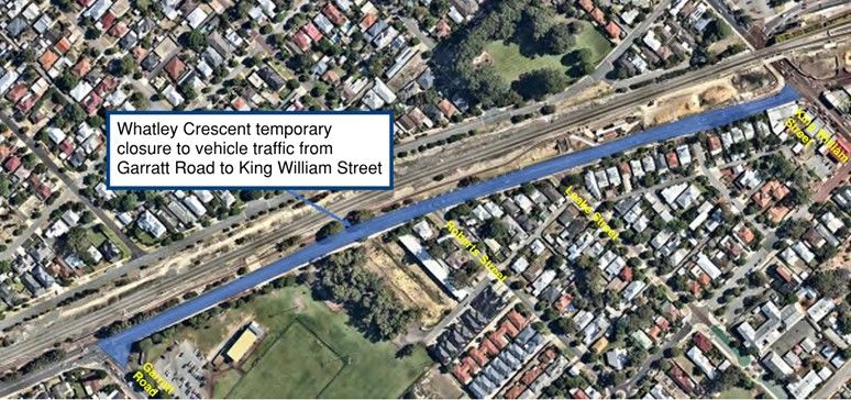
Ordinary Council Meeting Agenda                                                  29 June 2021

10           REPORTS

10.5         Major Projects Directorate Reports

10.5.1       Closure of Whatley Crescent (West), Bayswater

 Applicant/Proponent:         Evolve Bayswater Alliance
 Responsible Branch:          Engineering Services
 Responsible Directorate:     Major Projects
 Authority/Discretion:        Legislative
 Voting Requirement:          Simple Majority Required
 Attachments:                 1.    Consultation Letter [10.5.1.1 - 2 pages]
                              2.    METRONET Letter to Whatley Crescent Residents
                                    [10.5.1.2 - 2 pages]
                              3.    Consultation Survey Results [10.5.1.3 - 9 pages]
                              4.    Evolve Bayswater Alliance (EBA) Categorised
                                    Response [10.5.1.4 - 1 page]
 Refer:                       Item 10.5.1: OCM 25.05.21

SUMMARY
Council’s final endorsement is sought following public advertising for the proposed temporary
closure of a portion of Whatley Crescent between King William Street and Garratt Road,
Bayswater. The proposed closure is part of the construction works for the rail network and
installation of underground services associated with the redevelopment of the Bayswater Station.

The proposal was advertised for 21 days and a total of 126 submissions were received during the
period of public consultation.

From the public comments received, it was noted the majority of the concerns raised were traffic
related that ranged from access to potential rat-runs and congestion issues.

OFFICER'S RECOMMENDATION
That Council:
1.     Conditionally endorses the temporary closure to all vehicles, in accordance with
       Section 3.50 of the Local Government Act 1995, of the following portions of Whatley
       Crescent, Bayswater:
       (a)   Full closure of the road from Garratt Road to King William Street between
             4 October 2021 to 18 December 2021 as shown in Figure 1 in this report; and
       (b)   Full closure of the road including the King William Street and Coode Street
             intersection from 4 November 2021 to 22 November 2021 and from 27 November
             2021 to 15 December 2021 as shown in Figure 2 in this report.
2.     Advises Evolve Bayswater that the endorsement is subject to the implementation of
       the following temporary traffic measures at their cost to the satisfaction of the City
       during the closure period:
       (a)   Right turn phase to be incorporated in the signal phase for King William Street
             (Southbound) leg turning right onto Guildford Road at the King William Street
             and Guildford Road intersection (subject to Main Roads WA approval and at the
             cost of Evolve Bayswater);
       (b)   Right turn movement to be permitted on Guildford Road (Westbound) turning
             right onto Garratt Road at the Garratt Road and Guildford Road intersection
             (subject to Main Roads WA approval and at the cost of Evolve Bayswater);

                                            Page 3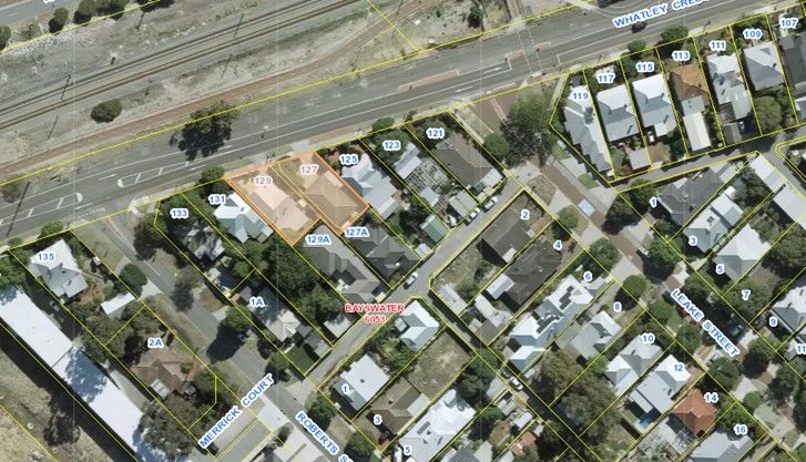
Ordinary Council Meeting Agenda                                                        29 June 2021

      (c)   Temporary speed plateaus or alternative traffic calming measures to be installed
            along Roberts Road, Murray Street and Almondbury Street; and
      (d)   Temporary traffic signals or an alternative treatment to be installed at the King
            William Street and Olfe Street intersection.

BACKGROUND
Evolve Bayswater Alliance (Evolve) has written to the City requesting temporary closure of a
portion of Whatley Crescent to facilitate works associated with the construction of the new
Bayswater Station. The road closure is required as the works involve upgrading of public utility
infrastructure that is located underneath the Whatley Crescent road pavement as well as
construction of new infrastructure that will not allow vehicle traffic to pass through the site safely.

At its Ordinary Meeting on 25 May 2021, Council considered a report in relation to the proposed
temporary closure of a portion of Whatley Crescent and resolved as follows:

“That Council:
1.    Endorses the undertaking of consultation in accordance with Section 3.50 of the Local
      Government Act regarding the temporary closure to all vehicles of the following portion of
      Whatley Crescent, Bayswater:
      (a)   Full closure of the road from Garratt Road to King William Street between 4 October
            2021 to 18 December 2021 as shown in Figure 1 in this report; and
      (b)   Full closure of the road including the King William Street and Coode Street intersection
            from 4 November 2021 to 22 November 2021 and from 27 November 2021 to 15
            December 2021 as shown in Figure 2 in this report.
2.    Advises the Public Transport Authority that prior to Council’s final consideration of the
      temporary closure of Whatley Crescent, the following are to be addressed:
      (a)   alternative access arrangements for private property and waste collection are to be
            resolved.
      (b)   provide confirmation that temporary traffic measures will be implemented to minimise
            impact on the local road network within the station precinct.”

EXTERNAL CONSULTATION
The City undertook consultation inviting comments over a period of 21 days as required under
Section 3.50 of the Local Government Act 1995 which included the following:

1.    Letters sent to Main Roads Western Australia (MRWA), service agencies and all landowners
      with property facing the relevant section of Whatley Crescent as well as all properties
      bounded by King William Street, Whatley Crescent, Guildford Road and Garratt Road on 26
      May 2021.
2.    A notice in The Eastern Reporter on 3 June 2021.
3.    The City’s community engagement website (Engage Bayswater) where information and
      maps were uploaded and the community were able to provide online feedback.

A total of 732 letters were sent out to affected landowners, occupiers and businesses as well Main
Roads Western Australia (MRWA) and various service agencies. A copy of the letter can be found
in Attachment 1.

                                               Page 4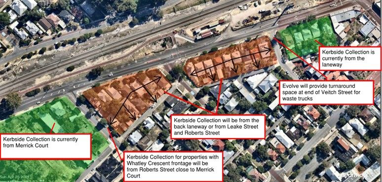
Ordinary Council Meeting Agenda                                  29 June 2021

The extent of properties the letter was sent to is shown below.

The notice that was printed in The Eastern Reporter is below.

                                              Page 5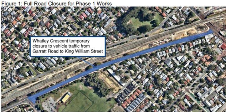
Ordinary Council Meeting Agenda 29 June 2021
Evolve has also undertaken consultation with the affected residents and businesses with properties
that front Whatley Crescent between King William Street and Garratt Road. A copy of their letter
can be found in Attachment 2.
OFFICER'S COMMENTS
The proposed road closure that was advertised consisted of closure of the full width of the Whatley
Crescent road carriageway from Garratt Road to King William Street for a total duration of 66 days.
Vehicular traffic will therefore not be able to access or travel on Whatley Crescent in either direction
during this period of closure.
The temporary road closure is necessary to facilitate the works required for the development of the
new Bayswater Train Station. The works that will be undertaken during the closure period included
the following:
Clearing of Hard landscaping
Replacement of Sewer Pressure Main
Rail Turnback works
Installation of Retaining Walls
Construction of Leake St Underpass
New Principal Shared Path (PSP)
Stormwater Drainage works
Roadworks – Resurfacing and reinstatement of road
Signs and Pavement marking
Installation of Concrete barriers
Lifting and placement of bridge spans
Closure of the full width of Whatley Crescent is necessary in particular to facilitate the upgrade and
installation of the realigned sewer pressure main as well as the construction of the new bridge. As
the existing and the new sewer pressure main are located directly underneath the Whatley
Crescent road pavement with portions in excess of 3 metres below the road level, full closure of
the road becomes the only option to enable excavation and installation of this infrastructure. The
full closure of Whatley Crescent and the King William Street, Coode Street intersection will also be
necessary to allow cranes to be set up for the lifting and placing of bridge components for the new
bridge overpass.
Details of the proposed road closure that was advertised is outlined below:
Phase 1 - consists of a full closure of Whatley Crescent to vehicular traffic for the entire
distance from Garratt Road to King William Street. This is required from 4 October 2021
to 18 December 2021.
Phase 2 – extending the full closure of Whatley Crescent to vehicular traffic for the
entire distance from Garratt Road to King William Street to include the King William
Street, Coode Street intersection. This will be required from 4 November 2021 to 22
November 2021.
Phase 3 – extending the full closure of Whatley Crescent to vehicular traffic for the
entire distance from Garratt Road to King William Street to include the King William
Street, Coode Street intersection. This will be required from 27 November 2021 to 15
December 2021.
Page 6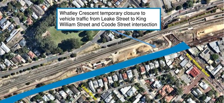
Ordinary Council Meeting Agenda 29 June 2021
The phases are illustrated in Figures 1 to 2 below.
Figure 1: Full Road Closure for Phase 1 Works
Figure 2: Full Road Closure for Phase 2 and 3 Works
As stated in the previous Council report, the City had raised a number of concerns with Evolve on
the potential impact the closure would cause to the community during the assessment of the
proposed road closure. These included:
Access to properties that have road frontage and driveway access off Whatley Crescent;
Waste collection where the properties’ kerbside collection is on Whatley Crescent;
R.O.W. (laneway) access for waste vehicles; and
Potential rat runs within the local road network.
Due to the above concerns, the following part recommendation was put forward for Council’s
consideration accordingly:
Page 7
Ordinary Council Meeting Agenda                                                    29 June 2021

“That Council:
…....
2.    Advises the Public Transport Authority that prior to Council’s final consideration of the
      temporary closure of Whatley Crescent, the following are to be addressed:
     (a)   alternative access arrangements for private property and waste collection are to be
           resolved.
     (b)   provide confirmation that temporary traffic measures will be implemented to minimise
           impact on the local road network within the station precinct.”

Private Property Access Arrangement
All the properties along Whatley Crescent consist of vehicle access via the back laneway with the
exception of two strata properties (127 and 129 Whatley Crescent).

Evolve has advised that they will provide a temporary access track from these properties to Roberts
Street in order to maintain vehicle access during the road closure period.

Waste Collection
The kerbside collection to properties on Whatley Crescent will be impacted due to this road closure
as waste vehicles will not have access to Whatley Crescent in order to empty the bins. As part of
the consultation Evolve has undertaken with the affected residents with properties on Whatley
Crescent, alternative access and collection locations have been arranged such that kerbside
collection can continue to be serviced to all the properties affected.

The following arrangement has been made with agreement from the affected residents and the
City’s Waste Contractor (Cleanaway):

Properties between King William Street and Veitch Street
It is not anticipated that there will be any changes to these properties as their current kerbside
collection is from the back laneway. Evolve will however provide sufficient pavement space at the
end of Veitch Street to allow waste trucks to turnaround.

                                              Page 8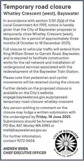
Ordinary Council Meeting Agenda                                                       29 June 2021

Properties between Veitch Street and Leake Street
The kerbside collection for these properties will either be from the back laneway or from the side
streets being either Veitch Street or Leake Street.

Properties between Leake Street and Roberts Street
The kerbside collection for these properties will also either be from the back laneway or from Leake
Street or Roberts Street. For the properties that only have front access to Whatley Crescent,
Evolve personnel will wheel out their bins from the property to the side streets on a weekly basis
for collection throughout the road closure period.

Properties between Roberts Street and Garratt Road
The kerbside collection for these properties is currently from Merrick Court and will therefore not
be affected.

The figure below provides a summary of the arrangements made by Evolve to address the waste
collection for the properties that will be affected by the closure.

Community Submissions
Following the closing of the public consultation period, the City received a total of 126 submissions.
124 of these submissions were from residents, landowners and business owners and two were
from service authorities which were Western Australia Police Force (WA Police) and Department
of Fire and Emergency Services (DFES). Both WA Police and DFES advised they are aware of
the station works and have no objections to the proposed closure. A summary of the submissions
received is enclosed as Attachment 3.

Although a substantial amount of submissions were in support of the closure proposal with a
number of residents expressing their preference for the works to be completed in the least amount
of time, there was a considerable number of residents who expressed concerns with the closure.
The majority of these concerns were traffic related, in particular potential rat-run within the local
road network and traffic congestion issues. Impacts on businesses in the area was also raised as
an issue in a number of submissions.

Rat-Running
The rat-run issues raised relate to regional traffic using the local road network rather than the
distributor roads. Due to the disruption to the distributor road network caused by the closure,
residents have expressed concerns with the amount of traffic that is likely to increase on roads
such as Roberts Street, Murray Street and Almondbury Street.
                                               Page 9
Ordinary Council Meeting Agenda                                                         29 June 2021

King William Street and Guildford Road Intersection
Issues have been raised by residents in relation to the southbound traffic on Coode Street that will
be unable to turn right onto Whatley Crescent due to the proposed closure. The concerns stemming
from this issue would be that this volume of traffic will be re-directed to continue straight through
along King William Street towards Guildford Road. This will in turn create further queuing delays
on the right turn movement at the King William Street and Guildford Road signalled intersection.

Garratt Road and Guildford Road Intersection
A number of residents have requested allowing right turns from Guildford Road westbound onto
Garratt Road northbound as traffic will be unable to access the Hotham Street Bridge from Whatley
Crescent due to this closure.

Murray Street, Almondbury Street and Garratt Road Intersection
Several number of residents have requested removing the central median island on Garratt Road
at either the Murray Street or Almondbury Street intersections. This is such that northbound traffic
on Garratt Road will be able to turn right into these local roads given right turns will not be permitted
at Whatley Crescent. The City however has some reservations in relation to the removal of the
medians as this could have the potential to attract regional traffic into the local road network. It is
therefore recommended that Evolve undertakes further consideration on these measures in order
to avoid creating potential rat-run issues.

Whatley Crescent, Coode Street and King William Street Intersection
As the proposed closure also extends to include the King William Street and Coode Street
intersection to facilitate the construction of the new overpass bridge, some residents have
expressed dissatisfaction to this additional closure. The concerns were mainly due to the potential
segregation between the residents north of the rail line and the disruption to businesses this will
cause in particular leading up to the Christmas holiday period.

Olfe Street Access
Another concern that has been raised by residents was the difficulty with vehicles exiting Olfe
Street onto King William Street due to the current closure of Whatley Crescent East at Hamilton
Street. It is anticipated that this issue will be exacerbated due to the expected high traffic volumes
on King William Street caused by the closure.

Impact on Local Businesses
A number of businesses have expressed concerns with the adverse impact the proposed closure
would have on the local businesses in the town centre and have therefore not given support to the
closure proposal.

Evolve Bayswater Alliance (EBA) have categorised various concerns from the submissions
received and their response forms Attachment 4.

Temporary Traffic Measures
Whatley Crescent is classified as a District Distributor road under Main Roads WA’s road hierarchy,
as such, it carries traffic between suburbs and regions and provides connection to other distributor
roads.

Similar to the Bayswater Triangle Road network area which is bordered by King William Street,
Whatley Crescent, Newton Street and Guildford Road, the road network to the west of King William
Street is a local network cell that is bounded by Garratt Road, Whatley Crescent, King William
Street and Guildford Road. These roads are all distributor roads in particular Guildford Road which
is classified as a Primary Distributor Road.

                                                Page 10
Ordinary Council Meeting Agenda 29 June 2021
Primary Distributors are managed by MRWA and provide for major regional and inter-regional
traffic movement and are designed to carry large volumes of traffic.
Because the proposed closure of Whatley Crescent is between Garratt Road and King William
Street which are also distributor roads, the City has requested that Evolve’s Traffic Management
Contractor take into consideration during the development of their traffic management plans to
implement measures such that any regional traffic will remain on the distributor road network rather
than be diverted through the local road network.
To address the above concerns, it is recommended that the following measures be implemented
throughout the closure period:
Right turn at King William Street and Guildford Road Intersection
Given the southbound traffic on Coode Street will be unable to turn right onto Whatley Crescent at
the Whatley Crescent and King William Street intersection, it is recommended that improvements
be made on the right turn movements at the intersection of King William Street and Guildford Road.
The current southbound traffic turning right from King William Street onto Guildford Road is under
a green light filter. Considering that there will be an increased likelihood on the turning volumes
for this movement, it is considered appropriate for the current traffic signals to be modified to
include a right turn arrow phase to reduce the queue lengths and delays. It should be noted that
this would be subject to MRWA approval.
Right turn at Guildford Road and Garratt Road Intersection
Given the westbound traffic on Guildford Road is currently not permitted to make right turns onto
Garratt Road, and that a portion of north and westbound traffic will be unable to access the Hotham
Street Bridge via Whatley Crescent, it is recommended that consideration be given to modify the
traffic signal at the Garratt Road and Guildford Road intersection such that right turn movements
are permitted on Guildford Road (Westbound) to turn right onto Garratt Road whilst the road
closure is in place. It should be noted that this would also be subject to MRWA approval.
Traffic Management Devices on Roberts Road, Murray Street and Almondbury Street
In an attempt to mitigate the extent of any potential regional through traffic and any rat-running
traffic within the local road network cell, it is recommended that the City require Evolve’s Traffic
Management Contractor to implement various temporary traffic management devices on roads
such as Robert Street, Murray Street and Almondbury Street. It is anticipated that these additional
measures will further encourage any regional traffic to remain on the distributor road network such
as King William Street, Guildford Road and Garratt Road and to discourage the use of the local
road network as a short cut.
King William Street and Olfe Street Intersection
Given several residents have expressed difficulty with entering King William Street from Olfe Street
in particular during peak hour periods due to the high traffic volumes on King William Street, it is
recommended that some form of temporary treatment be implemented at this intersection to reduce
the extent of delays to motorists.
LEGISLATIVE COMPLIANCE
Section 3.50 of the Local Government Act 1995 outlines the requirements relating to the closure
of roads to vehicles. The provisions include that prior to approving a closure exceeding four weeks,
the local government is to:
“..(4)..
(a) give local public notice of the proposed order giving details of the proposal, including
the location of the thoroughfare and where, when, and why it would be closed, and
inviting submissions from any person who wishes to make a submission; and
Page 11Ordinary Council Meeting Agenda 29 June 2021
(b) give written notice to each person who —
(i) is prescribed for the purposes of this section; or
(ii) owns land that is prescribed for the purposes of this section; and
(c) allow a reasonable time for submissions to be made and consider any submissions
made.”
The consultation that was undertaken as outlined in the External Consultation section of this report
complied with the requirements of the Act.
RISK ASSESSMENT
In accordance with the City’s Risk Management Framework, the officer's recommendation/
following options have been assessed against the City’s adopted risk tolerance. Comments are
provided against each of the risk categories.
Officer's That Council:
Recommendation
1. Conditionally endorses the temporary closure to all vehicles, in
accordance with Section 3.50 of the Local Government Act 1995, of the
following portions of Whatley Crescent, Bayswater:
(a) Full closure of the road from Garratt Road to King William Street
between 4 October 2021 to 18 December 2021 as shown in Figure 1
in this report; and
(b) Full closure of the road including the King William Street and Coode
Street intersection from 4 November 2021 to 22 November 2021 and
from 27 November 2021 to 15 December 2021 as shown in Figure 2 in
this report.
2. Advises Evolve Bayswater that the endorsement is subject to the
implementation of the following temporary traffic measures at their cost
to the satisfaction of the City during the closure period:
(a) Right turn phase to be incorporated in the signal phase for King
William Street (Southbound) leg turning right onto Guildford Road at
the King William Street and Guildford Road intersection (subject to
Main Roads WA approval and at the cost of Evolve Bayswater);
(b) Right turn movement to be permitted on Guildford Road (Westbound)
turning right onto Garratt Road at the Garratt Road and Guildford
Road intersection (subject to Main Roads WA approval and at the
cost of Evolve Bayswater);
(c) Temporary speed plateaus or alternative traffic calming measures to
be installed along Roberts Road, Murray Street and Almondbury
Street; and
(d) Temporary traffic signals or an alternative treatment to be installed at
the King William Street and Olfe Street intersection.
Risk Category Adopted Risk Appetite Risk Assessment Outcome
Strategic Direction Moderate Low
Reputation Low Moderate
Governance Low Low
Community and Stakeholder Moderate Moderate
Financial Management Low Low
Environmental Responsibility Low Low
Service Delivery Low Low
Organisational Health and Safety Low Low
Conclusion This option is considered to carry a moderate risk in terms of community and
stakeholders as the City has put forward a number of measures for Evolve to
implement based on community feedback. Although the closure is necessary for
the development of the new station, there may be some landowners, businesses
and residents who remain opposed to the closure.
Page 12Ordinary Council Meeting Agenda 29 June 2021
Option 2 That Council endorses the temporary closure to all vehicles, in accordance
with Section 3.50 of the Local Government Act 1995, of the following
portions of Whatley Crescent, Bayswater:
(a) Full closure of the road from Garratt Road to King William Street
between 4 October 2021 to 18 December 2021 as shown in Figure 1
in this report; and
(b) Full closure of the road including the King William Street and
Coode Street intersection from 4 November 2021 to 22 November
2021 and from 27 November 2021 to 15 December 2021 as shown
in Figure 2 in this report.
Risk Category Adopted Risk Appetite Risk Assessment Outcome
Strategic Direction Moderate Low
Reputation Low High
Governance Low Low
Community and Stakeholder Moderate High
Financial Management Low Low
Environmental Responsibility Low Low
Service Delivery Low Moderate
Organisational Health and Safety Low Moderate
Conclusion This option is considered to carry a high risk in terms of community and
stakeholders as the City has put forward a number of measures for Evolve to
implement based on community feedback. Although the closure is necessary for
the development of the new station, there may be some landowners, businesses
and residents who remain opposed to the closure.
Option 3 That Council does not endorse the temporary closure of portions of Whatley
Crescent, Bayswater to all vehicles, in accordance with Section 3.50 of the
Local Government Act 1995.
Risk Category Adopted Risk Appetite Risk Assessment Outcome
Strategic Direction Moderate High
Reputation Low High
Governance Low Low
Community and Stakeholder Moderate High
Financial Management Low Low
Environmental Responsibility Low Low
Service Delivery Low Moderate
Organisational Health and Safety Low Low
Conclusion Preventing the temporary road closure is considered to carry high risks in terms
of strategic direction, reputation and community and stakeholders as this would
be contrary to the City’s previous position on the 2019 development application
and may delay the construction of a State Government project or result in other
mechanisms being used to facilitate the closure with a less favourable outcome
to the City.
FINANCIAL IMPLICATIONS
There are no financial implications that are applicable. It is expected that all costs associated with
the road closure including implementation of all the traffic measures, setting out of traffic
management and traffic detours, and any further public notice to the community are the
responsibility of the Evolve Bayswater Alliance.
STRATEGIC IMPLICATIONS
In accordance with the City of Bayswater Strategic Community Plan 2017-2027 (as amended), the
following applies:
Theme: Our Built Environment
Aspiration: A quality and connected built environment.
Outcome B2: A connected community with sustainable and well maintained transport.
Page 13Ordinary Council Meeting Agenda 29 June 2021
The closure will facilitate the redevelopment of the Bayswater Station and surrounding precinct,
which is a step-change for public transport access in the Bayswater town centre.
CONCLUSION
To enable the construction of the new Bayswater Station, it is necessary to close a portion of
Whatley Crescent to vehicles. It is recommended that Council approves the temporary full closure
of Whatley Crescent between Garratt Road and King William Street for the period between
4 October 2021 to 18 December 2021 subject to Evolve implementing the recommended
temporary traffic measures.
It should be acknowledged that there will be disruption and inconvenience caused to the residents
due to this closure, however, it is envisaged that the level of inconvenience would be exacerbated
if the recommended temporary measures have not been taken into consideration by Evolve during
the development of their traffic management plans for the closure.
Page 14Agenda 29 June 2021 Attachment 10.5.1.1
26 May 2021
«Owner_Name»
«Owner_Address_Line1»
«Owner_Address_Line2»
Dear resident/business operator
Proposed temporary closure of Whatley Crescent (west), Bayswater
The temporary closure of Whatley Crescent (west), Bayswater, to vehicular traffic, from King
William Street to Garratt Road, is required as part of the construction works for the rail
network and installation of underground services associated with the redevelopment of the
Bayswater Train Station.
The contractor requesting the closure, Evolve Bayswater, has indicated that a full closure
of Whatley Crescent from King William Street to Garratt Road will result in the necessary
works being completed in a significantly shorter timeframe.
If the full closure is not approved the works will need to be carried out with a series of
closures of different sections over an extended timeframe. This will take approximately 60
days longer to complete the works.
The works are extensive and are proposed to be completed in three phases:
• Phase 1 - consists of a full closure of Whatley Crescent to vehicular traffic for
the entire distance from Garratt Road to King William Street. This is required
from 4 October 2021 to 18 December 2021.
• Phase 2 – extending the full closure of Whatley Crescent to vehicular traffic for
the entire distance from Garratt Road to King William Street to include the
King William Street, Coode Street intersection. This will be required from
4 November 2021 to 22 November 2021.
• Phase 3 – extending the full closure of Whatley Crescent to vehicular traffic for
the entire distance from Garratt Road to King William Street to include the King
William Street, Coode Street intersection. This will be required from
27 November 2021 to 15 December 2021
Page 15Agenda 29 June 2021 Attachment 10.5.1.1
Proposed Temporary Closure of Whatley Crescent West, Bayswater Page 2
In accordance with section 3.50 (1)(a) of the Local Government Act 1995, notice is hereby
given that the City of Bayswater proposes to temporarily close Whatley Crescent (west),
between King William Street and Garratt Road, Bayswater, for a period of approximately
three months (4 October to 18 December 2021).
Please note that during the closure period pedestrian and cyclist movements along the
subject section of roadway will be retained.
Further details on the proposed closure are available on the City's website, Ordinary Council
Meeting Agenda, 25 May 2021, Item 10.5.1, https://www.bayswater.wa.gov.au/city-and-
council/council/council-meetings/agendas-and-minutes/2021/may/ordinary-council-
meeting-25-may-2021-agenda
Comments are invited on the proposed closure and should be lodged in writing with the
Chief Executive Officer, PO Box 467, Morley WA, 6943 or mail@bayswater.wa.gov.au by
Friday, 18 June 2021.
Should you wish to discuss this matter further, please contact the City's Manager
Engineering Services, Bryce Coelho, on 9272 0654.
Yours faithfully
DOUG PEARSON
DIRECTOR MAJOR PROJECTS
Page 16Agenda 29 June 2021 Attachment 10.5.1.2
20 May 2021
PROPOSAL TO TEMPORARILY CLOSE WHATLEY CRESCENT (WEST)
Dear resident,
Whatley Crescent, between Garratt Road and King William Street, will fully close to motorists for
two and a half months from October 2021 to relocate a sewer main to the middle of the road. A
number of alternative options were investigated but included some form of road closure, with the
next best option having a four month impact. The proposed approach is considered the safest,
with the shortest impact on the community.
A full closure of the King William/Coode St-Whatley Crescent intersection is also required in
November/December to lift the bridge beams into place. The details and length of this closure
are still being determined.
To make the most of this disruption we plan to complete significant works, including:
o Relocating a major sewer main to the middle of Whatley Crescent
o Completing turnback rail infrastructure
o Building the permanent principal shared path (PSP) to King William Street
o Upgrading the southern section of the Leake St underpass
o Lifting the new bridge beams into place.
We are seeking feedback from impacted residents to help inform our construction mitigation and
management plans. A formal consultation process will begin in late-May and you can make a
submission via the City of Bayswater’s consultation channels.
What to expect
• Final construction details will be provided closer to the start of works.
• To minimise impacts, the majority of works will be completed during the day, however
some night works are expected. You will be notified in advance of any planned after-
hours work.
• There will be no vehicle access to this section of Whatley Crescent during the closure.
• Pedestrian access and a PSP detour route will be maintained at all times.
• Access to the Leake St underpass and crossing will be maintained, except during school
holidays when we work on upgrading the underpass.
Expected impacts to Whatley Crescent properties
We will work with you to minimise the impact on you and your property. We have identified the
following impacts and are seeking information from you about:
• property access
• waste collection.
We will provide further updates regarding construction timelines and impacts closer to the date.
Kind regards
METRONET team
New Bayswater Station Project
Page 17Agenda 29 June 2021 Attachment 10.5.1.2
Location of works
Page 18Agenda 29 June 2021 Attachment 10.5.1.3
Survey Response
Please provide your feedback on the proposed temporary closure of Whatley Crescent (west)
1 This would be diabolical for all feeder traffic resulting in far to many trucks/cars using Almondbury as a thoroughfare. Near schools!
What will be put in place to stop traffic turning right on Murray Street and travelling down to Garret road past both Bayswater Primary and Saint Columbus. This is a high risk area for pedestrian interaction abs traffic during
2
school pick up and drop off times in particular.
Please close the roads and get the work over and done with in the shortest possible time. These works are having multiple negative impacts for residents and the best thing that could be achieved is the most speedy
3
conclusion possible.
I am concerned about the extra congestion this will create in our area (Roberts st, between Guildford Rd and Whatley Cres) in the morning commuter peak, and onward effects from funnelling all commuter traffic onto
Guildford Rd. Commuters city-bound who normally had a safe left turn out onto Whatley Cres, will now have to turn right onto Guildford Rd at a busy time, with extreme risk of accidents. This also funnels a high amount of
4 traffic onto Guildford Rd city-bound, creating a very high load onto an already congested part of the network at peak times.
For effective mitigation, there should be one or more right-turns enabled from Murray St or Almondbury St onto Garret Rd northbound. This would allow traffic to exit this area without encountering Guildford Rd, and filter into
Whatley Rd as normal.
Closure of Whatley Crs would exasperate rat running along Murray and Almondbury. If it was considered, traffic would have to be blocked at the KWS and restricted at Garrett and Murray&Almondbury intersections to ensure
5 Coode and Beachboro Rd traffic do not cut through the school and residential zones. All traffic must be retained on Garrett, Guildford and King William Streets. It would make droop off at schools more dangerous for
approaching parents, having to turn right across traffic from Guildford Rd into Leake, Roberts and Milne.
6 Please complete the work in the shortest time possible to avoid more disturbance in the local community
Hi, This doesn’t provide the two alternatives so people can see which is better for them. It only provides the shortened works street closures. The longer time but less closures may be better for some people but we don’t know
as they’re not described. For me, living on one side of Coode Street (Armada), with our child’s daycare (Sonas) in Newton street - it looks like the most direct route for the six weeks of Coode St intersection closure become a
7
very long and dangerous trip where I have to try cross across lanes of Guildford road to get to her centre in a very round about way. I also hope we don’t lose our local businesses as the seem to be suffering with the works
already.
There are currently not many alternatives for getting from north of the train line to south. This has already been a massive issue adding huge delays to travel. This would force me to go on Tonkin hwy to get home from work
which I typically avoid because there are also road works there and in the afternoons traffic is basically stopped and it is dangerous because of people stopping and starting and becoming frustrated. I feel that during this
8 whole process almost no thought has been put into how this impacts locals. Nothing has been done to reduce the impact to us. My already long trip home has already increased by about 15 minutes. With this road completely
closed that will force everyone onto Tonkin hwy or over the railway pde bridge which is also already heavily congested, which is only going to make traffic in those areas even worse and cause more frustration and risk of
accidents. I personally would rather the work took a little longer and the rd was closed over weekends (or whenever the short closure periods were planned for) than every single work day and finishing slightly earlier.
The Traffic Management Plan does not specify diversion routes for traffic that normally use Whatley Crescent to head towards the city on weekday mornings. In the absence of an appropriately timed turning lane from King
William St to Guildford Rd heading towards the city, traffic on King William can only back-up causing excessive delays in travel time. This will force more traffic through residential 'rat runs' and past primary schools during
9
peak hour traffic, as is already occurring with the partial closure of Whatley Crescent from Hamilton St to King William St. It is also unclear how the risk assessment indicates noise from traffic diversions will be constant during
the combined full/partial closure, but no noise from traffic diversions is indicated for the full road closure option, despite there being the same traffic diversions in place.
More traffic will be needing to turn right from king william onto guildford rd as a result of these closures. At present the light changes are very quick and only allow a few cars through, which is very frustrating. This will only get
10
worse unless the timing of the light changes to allow more cars to turn right or a right hand turn arrow is put in.
11 Supportive
It is already difficult with things as they are, and closing off this stretch of the road at one of the busiest times of the year is a big ask. Whilst we appreciate that this project will take time, full disclosure should have been done
12
at the start, and we all know that 60 days is the planned time to have it closed, but it will probably take longer than that. Local businesses have suffered enough as it is, please keep the road opened as originally planned!
13 Please don't it's already taking 3 times longer to get from my place on Beechboro Rd Sth to Whatley as it is
14 These planned road closures could have a very significant impact on local businesses and their customers. What if anything has been done to reroute traffic to make the impact less significant.
Living on Roberts St, we witness a lot of congestion- particularly during peak and school drop off time. The closure of Whatley would make Guildford Road extremely congested. Is it possible to allow a right hand turn from
Murray St onto Garrett Road so that traffic could avoid the Guildford Road congestion?
15 There must also be a consideration for how people from our block (Roberts St) get, for example, to Bayswater Waves. If the Coode/King William intersection is closed along with Whatley Cres being closed, the only way to
get to Morley would be via Tonkin Highway. Again, a right turn onto Garrett Road from Murray St would allow us access to that side of the railway line and Railway Parade.
I appreciate the works being done in a timely manner, but there could be some changes made to lessen the impact on residents. Thank you.
Whilst I understand the need for road closures to facilitate station works, as a local resident I am concerned about the extent of time of the proposed full closure of Whatley to include the King William/Coode St intersection
(Phase 2 and 3). This will essentially result in a major intersection being closed from 4 November to 15 December.
The "traffic management" report gives absolutely no detail on how traffic will be managed in this period. It is not a traffic management report - it is a project management report about what needs to be done and proposed
road closures. No information on traffic management during the closures is provided.
As I understand from the report, closure of the intersection will completely stop the flow of traffic north - south for six weeks. There appears to be no alternative routes for this traffic. The "traffic management" report does not
provide any information or details on traffic flows when this main access road is closed.
From my understanding, during Phase 2 and 3, if residents want to travel from the south pocket of Bayswater to the north, they can not, unless they "detour" down Guildford Road to Tonkin Highway and circle back around on
Collier. This is a ridiculous detour in length and does not even take into consideration the traffic nightmare and congestion that is Tonkin Highway due to related Metronet projects. The only other option is to detour down
Garrat, Guildford, Grafton and then circle back around on Whatley. Again, a ridiculous detour which would be awful in peak times.
The report mentions no impact on schools due to the lack of school buses, but it does not consider the number of parents who drive children to school. Also, whilst Bayswater Primary and St Columba's might not have school
buses, what happens to the 998 and 999 bus services that are heavily populated by high school students? Where will the buses detour to?
16 We live north of the railway line and have children at Bayswater Primary and John Forrest. As it seems on paper, the closure will cause major transport issues for car access to and from Bayswater, and for bus access to and
from the high school, so we will lose in both directions.
Page 19Agenda 29 June 2021 Attachment 10.5.1.3
The closure will completely isolate the north and south pockets of Bayswater. I do not support a full closure for that length of time without full information on how traffic will be managed - this information is not in the "traffic
management" report.
I am also not clear on the consultation on Phase 1 as this closure, and the period of the closure, is already detailed on the Metronet website. Although again, no information is actually provided on traffic management. Traffic
on Whatley toward the city is heavy, and I am concerned that when closed, traffic will detour down Murray and Almondbury, which are small residential roads running past schools and crossing the bike boulevard. Traffic in
this area is already much heavier due to recent traffic changes from the train station works. Traffic flow will also continue along King William to turn right at Guildford Road, where the lights at the intersection are set to favour
Guildford Road traffic flow. This will likely cause even heavier congestion on King William and will be extremely problematic for any residents in the pocket of Bayswater that has to use Olfe Street to access King William due
to the upcoming closure of Whatley (east). It seems the centre of Bayswater is just heading more and more toward gridlock.
In summary, I do not support the full closure in Phase 1 without consideration being given to Olfe Street access and traffic flow, and slowing down rat runs through Murray and Almondbury. I also do not support Phase 2 and 3
without proper consideration and modelling being given to traffic flows from south to north. The proposed works only serve to completely cut the two sides of the railway line off from one another, and there are no options
given for where and how the traffic will be managed.
The traffic lights at Guildford Rd & King William Street will need to be extended if this happens, currently we are lucky to get 3 cars through the intersection, especially turning right from King William into Guildford Rd heading
towards the city, as there is no arrow, and if cars are going straight from the river to King William/Coode Street. If we want to go straight from King William across Guildford Road (towards the river) we have to go in the right
lane, because the left gets an arrow, and to sit in that lane blocks them, so we have to sit in the right, and wait for all the cars/buses to turn right. Rat runs through Bayswater are becoming very busy, and this will only increase
these rat runs.
You will also need to increase the Garrett Road/Guildford Rd traffic lights to give more time to Garrett Road , especially for cars turning right onto Guildford Road (heading towards Bassendean), 3-4 cars at a time is
frustrating and blocks up the road. Give equal time both ways, it gets tiresome watching one road flow and the other sit at a standstill. 3 Times a week I come across Garrett Rd bridge and try to get to Coode Street, cars are
17 backed up, right back to the bridge some afternoons due to the Guildford/Garrett lights, eventually people use the rat run of Williamson St or Frinton St (doing illegal uturns of Garrett) just to avoid these lights.
As a resident of Coode Street & Francis St, it is becoming very dangerous on these roads due to the increased number of cars, with poor visibility due to the road conditions (blind hill). My driveway is on Francis St, and in the
mornings I find it very difficult to drive off my property because of the number of cars using Francis St as a rat run, and the increased number of cars using the street for train parking. So now Coode Street will only get busier,
because cars from Beechboro Rd will now use Drake Street and its side roads, Francis / Burnside/Copley to turn right onto Coode St and use its side streets to get access to Whatley/Railway Rd to head into the city.
To be honest Whatley St is a car park most days now, with cars backed all the way to Garrett road, so I try to avoid it by using side streets (poor residents). I am trying to patient and supportive of the process but closure of
Whatley Crescent will be frustrating for all...but I guess you will do what you have to do.
As one of many parents with children at Maylands Peninsula Primary School/Bayswater Primary School and John Forrest High School, using Garratt Road and Whatley crescent for morning and afternoon drop offs and pick
ups is the only feasible route. The only other option is going back down to Guildford Road and turning left into an already congested and painfully slow moving King William Street. Public transport is not an option for the part
18
of Bayswater we live in, which is already suffering enough with the closure of Dunstone road for 7 months with the Tonkin Gap project. I have another child that goes to Cyril Jackson and the hassles of getting him to school
are bad enough with having to get onto Guildford Road and turn right! Thank you.
19 You will create massive traffic issues at the king William and Guildford road lights, creating a potentially dangerous situation and frustrating for all those turning right.
20 We have two flats at 222 Whatley crescent Maylands. Will we and our tenants have full vehicular access during the closure?
I note the word "required". No, this closure is NOT "required". It is nothing more than an easy option for 'Evolve', to the great detriment of local residents, who have been utterly ignored and their complaints summarily
dismissed.
'Evolve' is an out-of town mob who know absolutely nothing about Bayswater, and care even less. I spoke by phone to one of their people some months back and asked why they were so clearly acting against all the
'community consultations' which had taken place. And the guy said they did not know there had been any community consultations! This demonstrates total ignorance of everything which has gone on over the months and
years prior to them getting the contract, and now total ignorance of the impact on local traffic that this would cause.
21
I write this from my home of the last 23 years, located 200 metres from the rail line, and I am listening to pile drivers, which have been banging away all night long. Metronet and Evolve have been using construction methods
utterly inappropriate for a medium-density suburban location. They arrogantly and falsely claim there is no other way to do the job, when of course there are a great many quieter options.
I fully expect that the agenda behind this latest request is a financial one for them, either to avoid penalties for late completion, or to get a bonus for finishing early. It is most certainly not for the benefit of us, the residents and
ratepayers.
The answer from the City of Bayswater must be a very loud "NO".
Current road closures and traffic congestion, along with impending and proposed road closures will have a critical impact on the ability for emergency services (police & ambulance) responses to the immediate effected and
22 greater city of bayswater community. A single direction (one way) 24/7 emergency access and/or residential only controlled access should be established to reduce already significantly impact emergency response
attendance due to the access and traffic congestion.
we need a right turn onto Garratt Road, from one of the side streets to get back onto Whatley Crescent going towards the city or you are just putting everyone on Guildford and don't get me started trying to turn right from
23
Anzac Street and Slade Street in peak hour, I feel trapped and feel bad I have to use all these side streets to get out of Bayswater going towards the city
If this was to occur, there needs to be changes to the surrounding intersections to support local residents, like the King William and Guildford intersection to allow a RH turn arrow from King William onto Guildford to ease the
bank up on King William. And a RH turn from Guildford Rd onto Garrett Rd needs to be allowed to access the services on Garrett Rd (soccer club, tennis). I live on Francis St between Drake and Coode and this closure will
24
severely impact my day to day routine to get to the freeway and to get my children from running club (2x pw) and soccer (3× pw) at Frank Drago Reserve, as i will not be able to turn right onto Garrett from Murray St or right
onto Garrett from Guildford. And turning right onto Guildford from any of the feeder streets (Roberts, Leake, Milne) is near on impossible.
Suggest to permanently reinstate the right turn west into Garratt from Guildford Rd. Between Guildford and the railway line Garratt ( 2 lane) seems to get less traffic than King William ( 1 lane) mainly due to no right turn into
25
Garratt which is adding to congestion at Bayswater Village. Will help a bit with the temporary arrangements
I have no issue with the closure however the timing of the signals at the Garratt Rd/Guilford Rd intersection must be reviewed with this proposal in mind.
26
Currently traffic heading east along Garratt Rd (in peak hours) have only a short period of green light, traffic is banking up along Garratt Rd as a result of the increased activity due to drivers avoiding the current construction
area congestion. This will certainly need to be addressed otherwise its only going to get worse with this proposed closure.
I am against the shutdown of the entire section from Garret Rd to King William St. I think the current works are already driving customers away from Bayswater and if the section in question closes for 2.5 months ( no
guarantee this will be the actual real time frame ) customers will be forced to change the route they currently take and with human nature a change will very likely become a permanent change. I currently operate a business in
27
the area and I am less than happy about the situation and now this latest proposal to go till just before Christmas is just too much. I do not want any closure but would prefer the partial closure option with very careful planning
of when sections actually require restrictive vehicle access. We would like to survive the train station and the road works and still have a business at the end
You have decided this already, so what is the point of the exercise? You never listen to local residents concerns and just go ahead with every ridiculous decision already made by someone sitting in an office far from
Bayswater that doesn't care.
28 Bayswater Town Centre is rapidly being ruined, it is disturbing and alarming. I really think that full compensation should be paid to all owners of business's on Whatley Crescent East of the King William/Whatley Crescent
intersection. And by full compensation, I mean the purchase cost of the business, including chattels, improvements and goodwill.
No consideration for motorists or the disabled only cyclists and able bodied pedestrians. People with cars have time management to consider too.
29 The shorter the disruptions the better, so I prefer full closure, rather than a prolonged and drawn out situation.
How do we ensure that traffic ends up using Murray St in lieu of Whatley Crescent with people turning right from King William St. Traffic and speed is already an issue on Murray St.
I would imagine traffic should be directed down King William St and on to Guildford Road.
30 I would be keen to understand how traffic will be managed during this time.
Also keen to understand pedestrian access for students to connect with buses to schools on the western side of the railway line (e.g JFSC, Chisolm, others) when the intersection of King William and Whatley are closed.
Will pedestrian access still be available during this time to connect with buses on Coode St.
Page 20Agenda 29 June 2021 Attachment 10.5.1.3
31 Residents would really like the Caledonian Avenue crossing removed so we aren't woken up by train horns at all hours of the day and night.
32 Will I be able to turn right onto Garret Rd from Roberts Rd then?
33 Its going to be a fest of enormous proportions - but why bother to consult if it has to happen anyway. wingers will be wingers - just get on with it
I’m against the extra closure. It will mean it’s harder for longer for us to move around our suburb and live our already impacted lives. Northern Bayswater and Southern Bayswater will basically be cut off from each other - how
34
will parents get their children to and from school if they live north of the train line? I understand the intersection has to be closed to construct the bridge, but to close it for 6 weeks in stead of 3 is a bit much!
Why this hasn't been communicated with the community before this date?? Looking the plans attached I can see that Whatley Cres will become a concrete eyesore with no plans on what trees will be planted and where they
will be planted considering there is hardly any space on either side of Whatley Cres for trees to grow and survive.
35
These plans should have been communicated with the community since the beginning of the project considering MEL Line was confirmed to run in the area since 2019.
Now what we will see is major traffic delays for the two and half months of works, on King William considering its the last controlled intersection linking people on with Guildford road and other side of the river.
Absolutely stupid idea with zero consideration or care for residents.
36
37 Will pedestrian access to *cross * where the traffic warden assists school children at the end of Leake St to the subway be retained?
1. Naturally this closure will create a lot of rat-run traffic throughout the local streets. Often this type of re-route/rat-run traffic is met with some erratic and impatient driving due to the driver being inconvenienced and having to
take often a longer route than usual. My question is, "how will Metronet assure us that traffic calming measures will be put in place for the obvious rat-run streets"? I note that at present there are several streets
(Murray/Leake/Almondbury etc) that are being used as alternate (rat-run) routes without any slowing down methods included.
2. A concern is, when Whatley Cres is fully closed off at Hamilton St, all the local triangle feeder streets will need to enter and exit via Slade/Olfe to arrive at King William St. For a start, the T junction on Olfe St (at KWSt) will
need to be widened slightly to allow for a comfortable left and right turn. At present it is a very tight move often only one vehicle fits. This would be a very simple and practical modification, in fact I don't know why it hadn't
been done in the past? This is a popular pedestrian crossing point as well, hopefully some consideration for safe crossing for pedestrians will be included.
3. Turning right from Olfe to KWSt during peak pm will be almost impossible as the line of traffic is mostly banked to Guildford Rd. Even now turning right is obscured slightly by the bus stop side mesh ... can it be changed to
glass or just removed? Is the future plan for lights at this intersection?
4. I note that Metronet have suggested a possible RH turn into Garratt Rd from Guildford Rd. This was promised by MRD several years ago and should have come to fruition but they have reneged on this. I made a phone
call enquiry recently and was told that it was too costly!? Interesting how this has now been suggested as a temporary modification. I would say, if it can be done as 'temporary' then it could stay as a 'permanent' !? This
modification would take a lot of traffic from the KWSt area.
38 5. More traffic calming will need to be installed for Slade St (from Aughton to Olfe) and for Olfe St as well. As I live in Slade St (#11) and have a speed hump in front, I have noticed a steady increase in speed as many cars
do not even slow down to go over the hump. With the imminent increase in traffic volume this will only get worse if further traffic calming measures are not put in place.
The dog-leg at Olfe/Hamilton will need to be modified including some reference to safe crossing for pedestrians coming to and from the Library/Community Centre. Traffic calming for the car park section on Olfe St should
already be in place let alone when it becomes a thoroughfare.
6. Ascot flats at 85 King William St/Guildford Rd Bayswater (over 200 units and up to 600 people). This complex has (from the outset) had it's principal entry/exit point at 85 King William St with a single lane entry/exit for
Town Houses at the rear (Slade St). Over the past years the complex has made several on/off changes to the entry/exit with the primary entry/exit at 85 King William St designated to entry only (with spikes) and exit only at
Slade St with a security gate.
From my information, the changes were instigated by their own internal corporate body. This goes unauthorised change against Ordinary and Proper Town Planning and contra to the original approval for this complex. This
modification has pushed all their exiting traffic onto a minor street ie Slade St. In the past they put inn place, a security ramped entry and exit (at 85 King William St) which seemed problematic. A subsequent change (and to
date in place) became, an entry only with spikes. I have of late noticed, the spikes have been removed but still showing 'entry only' (don't know if the spike removal is temporary?). It would be prudent to allow at least a left
turn from the principal entry/exit at 85 King William St to allow vehicles safe access to Guildford Rd. This is an unauthorised change of traffic movement for this complex and in turn creates negative issues for adjoining
streets, therefore I would hope that Metronet and City of Bayswater puts this issue forward for discussion and rectify the unauthorised changes.
39 Full closure for a shorter period is preferred to a long drawn out partial closure. Inconvenient but manageable.
1. There is a huge flow of traffic that moves from north of Bayswater station under the underpass and turns right onto Whatley Crescent, that will now be forced to go down King William Street to turn right on Guildford Road.
The traffic light timing at the King William/Guildford intersection will need to be extended to allow more traffic to turn right, as at the moment the lights only stay green for approx 10 seconds.
40
2. It isn't clear if the traffic referred to above will still be able to move under the underpass and cross the intersection during Stage 2 (Coode St intersection closure)? If not, how will the hundreds of cars every peak hour get
from north of the station onto the freeway? I can't even imagine the traffic mayhem the intersection closure will cause. This is extremely concerning.
What is the traffic management plan?
41
Where will the traffic that normally uses this road be diverted to?
Minimising night work and therefore impact on residents is supported. We have suffered under FAL through poorly planned and managed night work and don’t wish for others to go through what we have.
No mention of traffic modelling done (or not done) to assess impacts. We expect a serious traffic engineering study into impacts and mitigations. Don’t wait until it is a traffic disaster and then work out what to do.
Free right turns onto Guildford Rd are not a viable option for egress from Bayswater toward the city. This is a difficult and dangerous manoeuvre at all times except the middle of the night.
42
Right turns from Olfe onto King William are a particular concern to us; this should be properly analysed and addressed including queuing time. We don’t want to spend half an hour trying to leave our suburb, whether it be
turning right toward Whatley or left toward Guildford. Turning whilst towing (a caravan in this case) should also be considered in this analysis. Temporary traffic management or traffic control devices at this intersection should
not be discounted if queues are lengthy.
First up, great presentation, pretty, nice colours, well written et.al, BUT it does NOT address the diversion of all the traffic that travels along Whatley Crescent. Where is this to be diverted?
Below are the predicated 'rat-runs':
Traffic will turn onto Garrett Road because they cannot access Whatley Crescent.
1. The first street they can access is Murray St. This is a residential street with a major sporting complex, church and dedicated school zone. There is also a need to cross a dedicated cycle way. The right hand turn to King
William Street is not entirely easy at the best of times. I forgot to mention the round-about, give-way sign and bedlam with traffic in school zones. Parking along the road at all times means the traffic is reduced to one-way in
some parts.
2.The next street traffic can turn is Almondberry St. Another residential street with a dedicated School Zone and crossing a dedicated cycle path. Again, the problem with the right hand turn onto King William Street. Again, a
roundabout (inaccessible during school drop off and pick up times times) and a give way sign. Again, parking along the road at all times and a steep hill.
3. Now for the return trip. Right hand turn onto either Murray or Almondberry Streets. After negotiating all the hazards - look at that - no right hand turn onto Garrett Road. Those travelling down Murray St will reverse outside
our house, zoom down Crawford Street, right turn on to Almondberry Street to find the same problem. The same will occur down Almondberry Street
43
However, no problem if you have a 4-wheel drive, just mount the concrete road divider and you are on your way.
4. Crawford St, Roberts St and Milne St will become another way to access Guildford Road with a stop sign at Almondberry Road on Crawford St. The right hand turn onto Guildford Road is impossible at peak times.
5. Just how many cars will be travelling down the local streets? I propose it will be well over 10,000 each week day. How do I know this? Murray Street became the rat run when Whatley Crescent was closed earlier in the
project. In 1.5 hours (and on a Sunday afternoon) I counted over 1000 cars.
6. OK, now lets look at the potential for hazards and accidents. Where is the risk analysis on this? Likelihood of occurrence High/Extreme. Impact or consequence again High/Extreme.
This issue has been raised time and time again with Metronet. It has been talked around but never addressed. What will it take for Evolve (or should it be Dissolve?) to listen to the residents?
Please provide details of the study into the traffic diversion and impact it will have on residents
Include how it will be imposed (a 'local traffic only' sign just does not cut it). Most people drive around it or simply into it, knocking it over so there is no sign.
Also include how it will be monitored, including the number of people to be utilised to direct traffic at all times.
Also consider where the tow trucks may park during the day and night as it will become a 'hot spot' for accidents.
This will have a significant adverse impact on all Bayswater residents, businesses in the Town Centre and the Saturday markets.
44 Is there a reason why a traffic management option isn’t being used?
Also can you please consider - as a priority - upgrading the King William St / guildford road intersection to allow more cars through who are turning right from KW onto Guildford road heading towards the city
Page 21You can also read