URBANIZATION MECHANISM STUDY UNDER THE DYNAMIC OF STATE CAPITAL - ISOCARP
←
→
Page content transcription
If your browser does not render page correctly, please read the page content below
Haixuan ZHU,Sai LIU                               Urbanization Mechanism Study under the
Xiaoyu JIA, Jiang CHANG                                           Dynamic of State Capital

                                        Research Paper

  URBANIZATION MECHANISM STUDY
 UNDER THE DYNAMIC OF STATE CAPITAL
A Case Study about Northeast China with the Construction of the
      Chinese Eastern Railway in the Early of 20th Century
Haixuan ZHU, School of Architecture, Harbin Institute of Technology; Key Laboratory of Cold
Region Urban and Rural Human Settlement Environment Science and Technology, Ministry
                     of Industry and Information Technology, China
Sai LIU, School of Architecture, Harbin Institute of Technology; Key Laboratory of Cold Region
    Urban and Rural Human Settlement Environment Science and Technology, Ministry of
                          Industry and Information Technology, China
  Xiaoyu JIA, School of Architecture, Harbin Institute of Technology; Key Laboratory of Cold
 Region Urban and Rural Human Settlement Environment Science and Technology, Ministry
                        of Industry and Information Technology, China
 Jiang Chang, School of Architecture, Harbin Institute of Technology; Key Laboratory of Cold
 Region Urban and Rural Human Settlement Environment Science and Technology, Ministry
                       of Industry and Information Technology, China

Abstract
      Since the industrial revolution of the 18th century, the modern economic system
      gradually matured and rapidly expanded in the world, especially the state capital
      investment relying on the railway, which drastically changed the urbanization
      process and city agglomeration pattern around the world. At the end of the 19th
      century, due to the important strategic value of the Far East, Russia raised state
      capital, built the Siberian Railway directly to Vladivostok, especially the C.E.R.
      across Northeast China, induced capital competition among China, Japan and
      Russia around the port and railway construction right and management right,
      formed the SMR system centered on Dalian, the C.E.R. system centered on
      Vladivostok, and the Chinese railway system centered on Huludao, laid the city
      structure of the “hub-railway network-hinterland” model centered on the port city
      in Northeast China, which promoted the development of commercial cities, hub
      cities and industrial and mining cities. Under the special tariff system, China, Japan
      and Russia relied on port-railway capital competition, forming the city development
      dynamic mechanism oriented by the export-oriented economy, that has the
      important theory value for how to effectively use the state capital advantage to
      promote the development of the macro-regional city system in the context of
      economic globalization.

Keywords
      State Capital, Urbanization Mechanism, the Chinese Eastern Railway, Hub-Network-
      Hinterland Structure, Northeast China

                                             55th ISOCARP World Planning Congress Jakarta-Bogor, Indonesia
                                                          International Society of City and Regional Planners
Haixuan ZHU,Sai LIU Urbanization Mechanism Study under the
Xiaoyu JIA, Jiang CHANG Dynamic of State Capital
Foreword
After the industrial revolution of the 18th century, the modern economic system gradually
matured and rapidly expanded worldwide. In the 19th century, in the context of the Russian
Far East Policy and the Japanese Mainland Policy, the Far East, Especially Northeast China,
gradually became the focus of international competition due to its special geographical
location and abundant natural resources. Under the joint participation of China, Japan,
Russia and other countries, with the national military strength as the backing, the state
capital penetration as the means, and the harbor and railway construction as the carrier, a
fierce competition of rights and interests had been launched, which promoted the rapid
modernization and urbanization of Northeast China, which gradually became the region with
relatively developed social economy in the Asian, and even in the world in the early 20th
century, that has important value and significance in the history of modern human social
development and urban development. Based on this, the paper, taking the expansion of the
Russian and Japan colonialism in the Far East in the early 20th century as the background,
and taking the port and railway construction under the support of state capital as clue, with
literature research methods and field investigation methods, systematically sorts out the
urbanization process of modern Northeast China, explores the dynamic mechanism of
national capital on regional urbanization, to enrich the history study of urban development
in the modern Far East.
1. Natural and Historical Background of Modern Northeast China
In the early Qing Dynasty, according to the Sino-Russian Treaty of Nibuchu, the Northeast
China, east to the Sea of Japan, southeast to the Tumen River, northeast to Okhotsk Sea and
the Sakhalin Island, north to Waixinganling mountain, northeast to the Gelbiqi River, is
extremely large. (Ping Bu etc., 1987) After the Second Opium War, China and Russia signed
the Aihui Treaty and Beijing Treaty in 1958 and 1860, Russia occupied the vast land which
north of Heilongjiang River and east of the Wusuli River. (Ping Bu etc., 1987) Northeast China
of this paper, including today’s Liaoning, Jilin, Heilongjiang provinces, and Chifeng, Tongliao,
Xingan league in eastern Inner Mongolia and northeastern parts of Hebei Province. At the
end of Qing Dynasty, where was the jurisdiction of the Shengjing general, Jilin general,
Heilongjiang general, in addition, included the Inner Mongolia’s Zhelimmu League,
Zhaowuda league and Zhuosuotu league. During the Republic of China, where was Fengtian,
Jilin, Heilongjiang Province and northeastern part of Rehe Province.
1.1. Natural Geographical Environment of Modern Northeast China
The development of modern cities in Northeast China is restricted and supported by natural
geographical environment. In the Northeast China, the west part is the Daxinganling
Mountains, the north is the Xiaoxinganling Mountains, and the east part is the Long White
Mountains, which are the watersheds of the Liaohe, Sungari, and Inner Mongolia Plateau
rivers, the Heilongjiang main stream, the Suifen River, the Tumen River and the Yalu River,
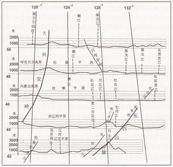
(Fig.1)“the mountains are not very high, all have a large forest, one of the rich sources of
Manchuria and Mongolia.”(Fujioka, 1929) The central part of the three major mountains is
the Songliao Plain, with the Changchun-Tongyu Line, the southern part is the Liaohe Plain,
the northern part is the Songnen Plain, accounting for about one-third of the Northeast
55th ISOCARP World Planning Congress Jakarta-Bogor, Indonesia
International Society of City and Regional PlannersHaixuan ZHU,Sai LIU Urbanization Mechanism Study under the
Xiaoyu JIA, Jiang CHANG Dynamic of State Capital
China, also accounting for one-third of Chinese plain, “this vast wildness, producing a large
amount of food, makes Northeast eligible to China’s barn.”(Chengjing Wang, 1947) “The vast
plains are not only suitable for agriculture, but also buried unmeasurable minerals.” (Fujioka,
1929) In modern times, the reserves of coal had been explored were 15 billion tons, the iron
ore reserves were not less than 2.7 billion tons, and the distribution of coal and iron
resources is very concentrated, laying the natural foundation for the development of
modern industry.
Figure 1 Schematic Diagram of the Natural Geographical Environment in Northeast China (Zhen
Li, 1993)
1.2. Urban Development in the Early and Middle Qing Dynasty
Northeast China, as the birthplace of the Qing Dynasty, began to build willow walls in the
early Shunzhi period, to prohibit the inside residents from crossing the wall for harvesting,
farming, hunting and grazing. The willow walls started from the south of Phoenix city, turn to
northeast to Xinbin, then turn to northwest to Kaiyuan, and then turn to the southwest to
Shanhaiguan connecting the Great wall. (Fig.2) During the Kangxi period, the new willow
walls were built from Kaiyuan to the Jilin. The interior of the walls was the jurisdiction of
Shengjing general, one side of the walls was the Mongolian pasture, the other side is the
royal paddock, the people of Han, Man and Mongolia were not allowed to cross the wall at
will. The willow walls were roughly build along the boundaries of natural climate, vegetation,
soil, etc. which were also the tangible economic zone, political system and cultural and
traditional boundaries.
1.2.1. City Development Status in the Southern Liaoning Region
The middle and lower reaches of the Liao River in the southern Region of the Northeast
China are located in warm temperate zones, with superior agricultural resources. In the first
year of Shunzhi, a large number of Manchus moved to China proper, led to the land
ridiculous. In the 10th year of Shunzhi (1653), due to financial difficulties, Liaodong
Reclamation Recruitment Order was issued, Liaoyang Fu was set up to lead Liaoyang Xian
and Haicheng Xian, and manage the local Han nationality. In the 7th year of Kangxi (1668),
the recruitment was stopped and the ban was imposed, but it did not prevent the Han
people from moving to the Northeast China. In the 10th of Xianfeng (1860), when Yingkou
55th ISOCARP World Planning Congress Jakarta-Bogor, Indonesia
International Society of City and Regional PlannersHaixuan ZHU,Sai LIU Urbanization Mechanism Study under the
Xiaoyu JIA, Jiang CHANG Dynamic of State Capital
was opened, Shengjing General governed Fengtain, Jinzhou 2 Fu; Liaoyang, Fuzhou, Yizhou,
Ningyuan 4 Zhou; Xingjing, Xiuyan, Phoenix, Cahngtu, Xinmin and Jinzhou 6 Ting; Chengde
Haicheng, Gaiping, Tieling, Kaiyuan, Jinxian, Guangning 7 Xian. All of these Fu, Ting, Zhou,
Xian, the Han area were mainly distributed on the banks of the Liao River and the coastal
Plain, where were the main agricultural area in the Northeast China.
Figure 2 Schematic Diagram of the Distribution of the Willow Wall (Qijun Zhang, 1966)
1.2.2. City Development Status in the Eastern Jilin Region
The eastern region of the Northeast China included the Long White mountain area, the vast
plains of the middle and lower reaches of the Sungari River and the Heilongjiang River,
where as the home of the Manchu ancestors, regarded as the holy land of Qing Dynasty, full
of paddocks and forests. Expect the Manchus, the residents were mainly Daurs, Ewenkis,
Oroqen and Hezhe, who lived in tribal forms, mainly fishing and hunting, the social economy
was very underdevelopment. Since the early of Qing Dynasty, the southern margin of Jilin
and Heilongjiang had agricultural development, relying on prisoners, traders, illegally
entered Han people, and the people who stole gold mines.(Tingyi Guo, 1987) During the
Sino-Russian Yaksa War, in order to resist the invasion of Russia, built the Post-road and a
large number of sailors and craftsmen were introduced. With the increase of immigrants, in
the 4th year of Yongzheng (1726), the Qing government set up Yongji Zhou, and set up
Changning Xian in Bodune and Taining Xian in Ningguta, this was the first administrative
setting in Jilin since the founding of Qing Dynasty. In the 13th year of Qianlong (1748), set up
Jilinn Ting. In the 5th year of Jiaqing (1800), set up Chuangchun Ting. In the 15th year of
Jiaqing (1810), set up Bodune Ting. In addition, the eastern region of Northeast China was
rich in ginseng, suede, antler, medicinal materials and other valuable specialty products,
there were active commodity transactions with China proper. Before the 6th year of
Yongzheng (1728), Ningguta was the center of specialty trades such as the fur of the
55th ISOCARP World Planning Congress Jakarta-Bogor, Indonesia
International Society of City and Regional PlannersHaixuan ZHU,Sai LIU Urbanization Mechanism Study under the
Xiaoyu JIA, Jiang CHANG Dynamic of State Capital
northeastern ethnic groups, every spring, the ethnic groups in the lower reaches of
Heilonngiang River came one by one, paying tributes such as suede, and selling all kinds of
skins in exchange for production and daily necessities. In the 7th year of Yongzheng (1729),
the Qing government decided that the tributes of the ethnic groups in the lower reaches of
the Heilongjiang River and the Wusuli River were managed by the Sanxing, and then Sanxing
replaced Ningguta and became the largest fur trade center. The valuable products in the
eastern region were sold to China proper, and exchanged for the items needed for
production and life, the business travels along the Post-road flourished and promoted the
cities development. (Zhaokui Xu, 1959)
1.2.3. City Development Status in the Western Heilongjiang Region
The northern part of northeast China included most of the Songliao Plain, the Daxinganling
Inter-span, and Keerqin sand land in the upper reaches of the West Liao River, where had
long been the cradle of the northern nomads. In the vast middle and upper reaches of the
Heilongjiang River, in order to defend against the invasion of Russia, the Qing government
set up Heilongjiang General in the 22nd year of Kangxi, originally stationed in Heilongjiang
City (Now Aihui), in the 29th year of Kangxi move to Mergen (Now Nenjiang). In the 38th
year of Kangxi (1699), as the land of Murgen could not accommodate the more people,
Heilongjiang General moved to Qiqihar, in 10th year of Xianfeng (1860), who commanded
Heilongjiang, Mergen, Qiqihar 3 deputy generals, Hulunbeier deputy head general manager,
Butehasuolun and Dahu 2 Zongguan. In this region, except for the Heilongjiang, Mergen,
Qiqihar and the Post-way station, as well as the Hulan River basin and Jieya River Basin and
the farmland of the prisoner, there were a few agricultural tribes, the vast region were
nomadic areas and safari areas. Inner Mongolia was adjacent to Heilongjiang Province,
mainly Zhelimu League, Zhaowuda League and Zhuosuotu League. The residents were
mainly Mongolian, and nomadism was the main economic mode. In the early of Qing
Dynasty, in order to obtain the necessary living and production materials, the Mongolians
organized the merchants went to Guihua and sold the livestock and livestock products.
Later,the merchants gradually went deep into the Mongolian grassland society, “loading
groceries with big wheel carriage, travelling around Mongolia.” Most of the merchants also
traded in the places where the population was concentrated such as the palaces, temples,
and the Post-way stations, and some also used the larger temples to hold temple trade. The
increase of merchants and the prosperity of trade had promoted the rapid development of
commercial cities in Mongolia. Especially from Shengjing, the Bahu Road, going north,
passing the Fakumen, Zhengjiatun to Qiqihar, where mostly was grassland, the traffic
conveniently, had become the important trade path. The Mongolians on the Hulunbeier
Grassland often traveled thousands of miles to Qiqihar for trading, afterwards, due to
difficulties in travel, they selected the land on the bank of Yimin River, where was fertile,
traffic conveniently, constructed several earthen houses, to attract Shanxi merchants, and
gradually developed into the Mongolian trade centre, now Hailar.
2. Modern City Development Based on State Capital Competition
The Northeast China is bordered by Japan in the south and Russia in the north. They were all
ambitious countries in modern times. Japan was trying to realize the Mainland Policy since
the Meiji Restoration. Russia intended to realized Peter the Great’s Eastern Estuary Plan. So
55th ISOCARP World Planning Congress Jakarta-Bogor, Indonesia
International Society of City and Regional PlannersHaixuan ZHU,Sai LIU Urbanization Mechanism Study under the
Xiaoyu JIA, Jiang CHANG Dynamic of State Capital
Northeast China became the battlefield for Japan and Russia hegemony in the Far East.
Japan and Russia had invaded the Northeast China with Military means and then carried out
large-scale capital invasions to ensure the realization of their military and political goals.
Modern Japan and Russia’s economic aggression was based on the intake of port and railway
construction rights, focusing on railway operation and resource development, controlling
trade circulation, and conducting colonial investment, especially the competition for the
construction and operation rights of the port and railway, rapidly promoted the modern
urbanization of the Northeast China.
2.1. Russia’s Far East Policy and Capital Expansion
2.1.1. The Far East Policy of Modern Russia
In history, Russia was a continental empire, during the period of Peter the Great, who made
the development strategy to find the seaport on east and west sides. In the 10th year of
Xianfeng (1860), according to Sino-Russian Beijing Treaty, Russia invaded the vast area east
of the Ussuri River and built Vladivostok into the military port for the Russian Far East Fleet.
Since the 1980s, due to the continuous setbacks in the expansion of Europe and Central Asia,
Russia actively operated the Far East. The main objectives of the Far East Policy: First,
invaded Korea and Northeast and Northwest China, and took where as the basis for further
encroachment on China; Second, with UK, USA and Japan to compete for hegemony in the
pacific, dominating the Far East.
2.1.2. The Chinese Eastern Railway Company and the Construction of the C.E.R. and
Dalian
After Russia invaded Haishenwai, renamed to Vladivostok, meaning “controlling the East.”
The west and southwest of Vladivostok is close to China and Korea, east facing Japan across
the sea, and the south is adjacent to Peter the Great Bay, which has the important strategic
position, but it has a freezing period of up to five months, this largely limits the actions of
Russian warships. Furthermore, Russia planned to build the Siberian Railway, if it could pass
Northeast China directly to Vladivostok and had an excellent non-freezing port, that would
be ideal for Russia to implement the Far East Policy. After the Sino-Japanese War, Russia had
made meritorious efforts to “force Japan to return the Liaodong Peninsula”, in the 22nd year
of Guangxu (1896), signed the “Sino-Russian Secret Treaty” with China, and obtained the
right to construct the C.E.R. in Northeast China. (Ping Bu etc., 1987) In the same year, China
and Russia signed the “Contract of Cooperation of the C.E.R. Company”, “Chinese will invest
5 million Kuping silver, establish the partnership with the Russo-Chinese Bank, the profits
and losses will be recognized as shares.” “the Russo-Chinese Bank is responsible for the
construction and management of the railway, and form the C.E.R. Company.” (Ping Bu etc.,
1987) In the 24th year of Guangxu (1898), Germany occupied Jiaozhou Bay, Russia took the
opportunity to dispatch the fleet occupy Lushun. In the same year, China and Russia signed
the “Lushun and Dalian Land Rent Treaty”, the first paragraph stated: “in order to preserve
the Russian Navy’s sufficient land use on the northern coast of China, China leases
Lushunkou, Dalian Bay and Nearby waters to Russia.” The eighth paragraph stated: “from
the date of signing, China allow build a branch Railway form a station of trunk railway to
Dalian Bay.” (Ping Bu etc., 1987) Since then, Russia realized the dream of seeking an
excellent non-freezing port in the Far East and the right to build the southern branch. In
August 1899, the Tsar issued the decree on the construction of Dalian Freeport, and took it
as the basis for operating the Northeast China. In the 27th year of Guangxu (1901), the C.E.R.
55th ISOCARP World Planning Congress Jakarta-Bogor, Indonesia
International Society of City and Regional PlannersHaixuan ZHU,Sai LIU Urbanization Mechanism Study under the
Xiaoyu JIA, Jiang CHANG Dynamic of State Capital
trunk line from Manzhouli to Suifeihe and then to Vladivostok was completed and opened to
traffic. In the 29th year of Guangxi (1903), the southern branch from Harbin to Dalian and
Lushun was completed and opened to traffic, and the situation of the Northeast China was
greatly changed. (Fig.3) At this time, Russia was in the heyday of the Northeast China, who
connected the C.E.R. to Europe via the Siberian Railway and attracted the world’s goods to
Dalian to import and export.
Figure 3 Northeast China Railway Network in 1907 (Author Self-painting)
2.1.3. Russia Controlling the Northern Region based on Port and Railway Facilities
After the Russo-Japanese war, Russia lost all the rights in the southern region, in order to
ensure the rights and interests in the northern region, who shifted the focus from Dalian to
Vladivostok, and used the C.E.R.to control the northern region of Northeast China. From the
perspective of specific economic behavior, the C.E.R. took Harbin as the midpoint and was
divided into three parts: the west line (Harbin to Manzhouli), the south line (Harbin to
Changchun), and the east line (Harbin to Suifenhe). The west line across Lubin, Hulun, Buxi,
Longjiang, Anda, Zhaozhou, Hulan seven Xian, shipping goods account for two-thirds of the
Heilonngjiang province. (the C.E.R. Economic Investigation Bureau, 1927) The east line,
crossing the eastern mountains, was dominated by forestry output. The south line, the area
is densely populated, the goods transported were mainly produced along the line. In
addition, the land in the lower reaches of the Sungari River was gradually developed in the
late Qing Dynasty. The C.E.R. and Sungari River shipping had established the intermodal
transport. The grain produced along the Sungari River were transported by inland water to
Harbin and the transported to Vladivostok via the C.E.R. (Lengjiu Yun, 1935) In order to
strengthen the central position of Vladivostok and to confront the Japanese-controlled
Dalian, The C.E.R. Administration had established the double freight rate standard for the
south line. In order to obtain goods from Changchun to Harbin and east to Vladivostok, the
freight fare of the south line was extremely low. At the same time, in order to prevent the
goods in the southern part from entering the northern part via the South Manchuria Railway
(SMR), which freight fare of the south line was extremely high. In 1917, the Russian October
55th ISOCARP World Planning Congress Jakarta-Bogor, Indonesia
International Society of City and Regional PlannersHaixuan ZHU,Sai LIU Urbanization Mechanism Study under the
Xiaoyu JIA, Jiang CHANG Dynamic of State Capital
Revolution, Vladivostok was occupied by the Allies, the port facilities were greatly damaged,
and the Ussuri Railway and the C.E.R. were almost completely out of service. In 1921, the
domestic situation of the Soviet Union resumed stability, the Ussuri Railway and the C.E.R.
returned to besiness, and Vladivostok’s trade also gradually recovered. In 1931, the Jilin-
Huining Railway was opened to traffic, all the cargo was transported southward. In 1935, the
Soviet Union had to sell the C.E.R. to Japan.
2.2. Japan’s Mainland Policy and Capital Expansion
2.2.1. the Mainland Policy of Modern Japan
In 1868, Japan’s Meiji Restoration, under the guiding principle of “expand the territory and
establish the national prestige in the world,” formulated the Mainland Policy, that is, using
force to invade the neighboring continent. In 1985, the Sino-Japanese War broke out, Japan
invaded the Liaodong Peninsula, and was interfered as conflict with the Russian Far East
Policy. In 1905, after the Russo-Japanese War, Japan inherited all the rights of Russia in the
southern region of Northeast China. In 1927, Japan clearly stated the aggression policy:
“want to conquer the China Proper, must first conquer the Manchuria and Mongolia.” After
the Manchurian incident in 1931, Japan fully encroached on the Northeast China, in the
course of its aggression and expansion, “Japan want to invade Manchuria and Mongolia,
whether the politic, economy or military, all need rely on railway, therefore, the railway
actually ranks first in Manchuria and Mongolia issue.” (Qi Zhu, 1930)
2.2.2. South Manchuria Railway Company and the Construction of “Three Ports and
Three Lines”
In 1905, after the signing of the Portsmouth Treaty between Japan and Russia, Japan
decided to follow the British East India Company, backed by the strength of the state, and
carried out railway management in the form of private company. (Chijun Hu, 2011) On June
7, 1906, the Japanese government established the South Manchuria Railway Company (SMR
Co. Ltd), and passed the “SMR Co. Ltd Regulations” on August 14. According to the
regulations, SMR Co. Ltd would operate the railways and affiliated businesses in northern
region of Northeast China, the company’s capital was 200 million yen, among which, the
government invested 100 million yen (50% of the shares). Although Japan recognized that
SMR was the joint property of China and Japan, but its vice presidents and directors were all
appointed and removed by the Japanese government, the business policies were also
decided by the Japanese government, and half of the company capital was state capital, all
of these determined that it was entirely a national policy institution. As the first president of
SMR Co. Ltd, Goto Shinpei said; “originally established SMR Co. Ltd and recommended me as
the president, probably not to regard the SMR Co. Ltd as a profitable cause, its essence was
the vanguard of the implementation of the imperial colonial policy or the empire
development.” (Fuquan Zhang, 1989)
In 1910, in order to compete with Russia, after occupied Korea, Japan established “Three
ports and Three Lines” program for the most convenient contact with Japan. First, the south
port and south line, namely Dalian port, SMR and Andong port, Angdong-Fengtian railway.
After 1906, Japan took Dalian port and SMR as the basis for capital expansion, in order to
control the cargo transportation of south of Changchun and compete with the C.E.R., a
special freight policy of ‘Dalian Centralism’ was adopted. During the Russo-Japanese War,
Japan built the light railway from Andong to Fengtian and forcibly rented it after the war. In
55th ISOCARP World Planning Congress Jakarta-Bogor, Indonesia
International Society of City and Regional PlannersHaixuan ZHU,Sai LIU Urbanization Mechanism Study under the
Xiaoyu JIA, Jiang CHANG Dynamic of State Capital
1911, the Yalu River Railway Bridge was completed, by 1913, the three-line transport of
“Japan, Manchuria and Korea” was realized, the goods could be transferred from the Japan
Tieshanyang railway to Busab, then to Xinyizhou railway of Korea,and then connected
Andong-Fengtian railway, directly to Fengtian of Northeast China. Second, the west port and
west line. In 1913, the Yuan Shikai government and Japan signed “the Summary of Railway
Loan Appointment Scheme,” Japan proposed the “Manchuria and Mongolia Five-Railways”
plan, which included the Taonan-Chengde Railway. (Ping Bu, 1987) In 1918, the Duan Qirui
government and Japan signed the “Manchuria and Mongolia Four-Railways Loan Preparation
contract,” Japan proposed the construction of Taonan-Rehe, and the branch to someone
port. (Yuou Lan, 1932) After the establishment of the Manchukuo, the Huludao Port was
expanded, and the Jinzhou-Chengde railway was built, so far, the western region of
Northeast China had a complete railway network and the nearest port. Third, the east port
and east line. East port took Korea Qingjin port as main port, and took Luojin port and
Xiongji Port as auxiliary ports. East line planned to use the Cahngchun-Huining railway as the
main line, with the Changchun-Dalai railway, Yanji-Hailin railway, Jilin-Wuchang railway as
the nutrition line. (Tongwen Wang, 1933) Japan’s construction of the Jilin-Huining railway
had experienced a long history, in 1923, they built the Tianbaoshan-Tumen light railway in
the name of mining. (Yuou Lan, 1932) By 1933, the Dunhua-Tumen railway was completed,
in 1935, luojin port was put into use, the mileage from the Japan via the Jilin-huining railway
to center of Northeast China was greatly shortened.
2.2.3. Japan Controlling the Southern Region Based on Port and Railway Facilities
On the basis of monopoly on ports and railway, Japan actively promoted the export of bean
goods to the world, and replaced national products with Japanese goods. In 1913, SMR Co.
Ltd carried out mixed storage and transportation of soybeans, soybean cakes, soybean oil
and wheat, to strengthen the control of the transportation and marketing of agricultural
products in Northeast China. With the cooperation of large Japanese commercial companies
and many small and medium-sized commercial enterprises, SMR Co. Ltd had monopolized
and controlled the commodity circulation network from ports, railways and hinterland
villages.
At the beginning of the establishment of SMR Co. Ltd, the investment was mainly focused on
railways, ports and other infrastructures, after the First World War, began to strengthen
investment in the industry and mining use the profits of transportation. Before 1931, Japan’s
industrial investment in Northeast China mainly carried out by SMR Co. Ltd, accounted for
60%. (C. F. Remer, 1953) SMR Co. Ltd invested 37.96 million yen in Anshan Iron Plant in the
two years of 1918 1919, accounting for 80% of the total profit. SMR Co. Ltd adopted the
comprehensive operation principle, in addition to railway, port and mine, also including
machinery, electricity, gas, coke and iron. At the same time, SMR Co. Ltd also invested
Japan’s private industry, especially the defense industry and emerging industries, for
example, which directly participated in the South Manchuria Sugar Company, Manchuria and
Mongolia Wool Company, Manchuria and Mongolia Fiber Company, they were known as
Fengtian three major companies. By 1931, SMR Co. Ltd had actually formed a huge trust,
including large and small enterprises, almost monopolized all the heavy industry in
Northeast China.
2.3. China’s Un-Treaty Port Policy and Capital Competition
2.3.1. Un-Treaty Port Policy in the late Qing Dynasty
55th ISOCARP World Planning Congress Jakarta-Bogor, Indonesia
International Society of City and Regional PlannersHaixuan ZHU,Sai LIU Urbanization Mechanism Study under the
Xiaoyu JIA, Jiang CHANG Dynamic of State Capital
Since the Sino-Japanese War, Japan and Russia had successively invaded Northeast China. In
the 26th year of Guangxu (1900), the Boxer Movement broke out, Russia occupied the entire
Northeast China. The important minister of the late Qing Dynasty, Zhang Zhidong, governor
of Hunan and Hubei province, proposed the Qing Government: “if the Northeast China open
to the world and trade with all the countries, all the interests of industry, commerce and
mine will be enjoyed by all countries, we collect the tax, that is what Westerners called the
opening for trade, also is the mutual containment strategy I proposed.” (Modern History
Data Editing Group, 1980) The Qing Government adopted Zhang Zhidong’s proposal,
rewarded the interests of the railway, mining, industry and commerce, and actively
contacted the UK, USA, Japan to restrict Russia, at the same time, these countries had also
prompted the process of opening up the Northeast China. In 1903, China and USA signed the
“Continuation of the Treaty on Trade and Transportation,” China opened two Un-Treaty
Ports, Fengtian and Andong. After the Russo-Japanese War, in order to coordinate the
contradiction among Japan, Russia and other countries in Northeast China, Zhang Zhidong
once again proposed the response of “opening up everywhere”. The Qing Government
quickly established the principle of opening up Northeast China. In December of the same
year, China and Japan signed the “Convention Treaty of the Northeast China” and
“attachment”. The first paragraph of the “attachment” stated: “Chinese government
promised, after the retreat of Japanese and Russian Troops, that will open the following Un-
Treaty ports: Phoenix City, Liaoyang, Xinmintun, Tieling, Tongjiangzi, Fakumen of Fengtian
province; Changchun, jilin, Harbin, Ningguta, Hunchun, Sanxing of Jilin province; Qiqihar,
Hailar, Aihui, Manzhouli of Heilongjiang province.” (Ping Bu, 1987) Since then, the
competition between the various countries including Japan and Russia in Northeast China
had gradually turned into capital invasion from military invasion. In 1909, China and Japan
signed the “China-Korea Tumen River Border Treaty,” and open Longjingcun, Juzijie,
Toudaogou and Baicaogou. (Ping Bu, 1987) In 1914 and 1916, Jinxian, Huludao, Taonan,
Liaoyuan, Kaiyuan, Xian of Fengtian province and Chifeng of Rehe opened as Un-Treaty ports,
the international trade network had been formed throughout the Fengtian province and Jilin
province and parts of Heilongjiang province and Rehe province.
2.3.2. Construction of Huludao Port and the East, West and South Three Trunk Lines
After the Russo-Japanese War, in the situation of the southern region and northern region
being controlled by Japan and Russia Respectively, the Qing government clearly recognized
the importance of port, railway construction and management rights, hoped to use the
“open door” proposal put forward by UAS to counter Japan and Russia. In terms of
competition in capital, the Harriman Railway Acquisition Plan, Xinmin-Fakumen Railway Plan,
Jinzhou-Aihui Railway Plan, and the Knox Railway Neutralization had been proposed, due to
the change of international relations, the resolute opposition of Japan and the compromise
of the Qing Government, these plans all soon died or halfway. (Chijun Hu, 2011) In the late
Qing Dynasty and the early Republic of China, in order to resist the economic monopoly of
Japan and Russia, China planned and implemented the Huludao port and the East, West and
South three trunk Line construction plan. First, Huludao port construction plan. Huludao,
about 12 kilometers form Lianshan station of Beijing-Fengtian railway, is a rare non-freezing
port in the Bohai Bay. In 1908, when Xu Shichang was the governor of the Northeast China,
he believed that a good seaport and a complete railway network were the key to
maintaining the rights of the nation, therefore, the British engineer xiusi was hired to survey
the Bohai Bay and chose Huludao as the port. Construction began in August 1910, and
55th ISOCARP World Planning Congress Jakarta-Bogor, Indonesia
International Society of City and Regional PlannersHaixuan ZHU,Sai LIU Urbanization Mechanism Study under the
Xiaoyu JIA, Jiang CHANG Dynamic of State Capital
stopped due to the Revolution of 1911. In 1920, Zhang Zuolin and the Beijing government
negotiated that the central government and the local government each invest 5 million yuan
to build the port, later as the civil war, stopped again. In January 1930, the Northeast China
Transportation Committee decided to continue construction and contracted with the Dutch
construction company, which was scheduled to be completed in five and a half years and
built into a large port with an annual throughput of 5 million tons. Second, the east, west,
south three trunk lines plan. In May 1924, in order to counter the SMR and the C.E.R., the
Northeast Fengxi Regime established the Northeast Transportation Committee, which
planned to build 35 railways up to 10,000 kilometers in 15 years, to form the Chinese
independent railway network, including: the east trunk line, from Huludao via Jinzhou,
Shenyang, Hailong, Jilin, Wuchang, Yilan to Tongjiang in the lower reaches of Hilonngjiang
River; the west trunk line, from Huludao via Jinzhou, Dahushan, Tongliao, Taonan, Angangxi,
Qiqihar, Nengjiang to Heihe; the south trunk line, from Huludao, via Chaoyang, Chifeng to
Duolun of Inner Mongolia. In 1921-1931, the northeast Fengxi government, using national
capital and technology, completed 10 railways including Dahushan-Tongliao railway,
Fengtian-hailong railway, Jilin-hailong railway, Hulan-Hailong railway, Qiqihar-Keshan railway,
Taonan-Suolun railway etc., the total length up to 1,521.7 kilometers, accounting for 25% of
mileage of Northeast China. (Naikun Yang, Yanxiong Cao, 2005) (Fig.4)
Figure 4 Northeast China Railway Network in 1931 (Author Self-painting)
2.3.3. China’s Economic Confrontation Rely on Port and Railway
At the end Qing Dynasty and the beginning of the Republic of China, the Northeast China
local government built Chinese own railway, breaking the situation that foreign capital
monopolized the railway network, forming the SMR network under the jurisdiction of Japan,
The C.E.R. network jointly managed by China and Russia, and China own self-built railway
network, China had supervision and management right over two railway networks. In
December 1929, in order to recover the railway controlled by the Japan, the Fengxi authority
55th ISOCARP World Planning Congress Jakarta-Bogor, Indonesia
International Society of City and Regional PlannersHaixuan ZHU,Sai LIU Urbanization Mechanism Study under the
Xiaoyu JIA, Jiang CHANG Dynamic of State Capital
formulated the cargo transport plan of the west four lines (Beijing-Fengtian railway, Siping-
Taonan railway, Taonan-Angangxi railway and Qiqihar-Keshan railway). In January 1931, the
east four lines (Beijing-Fengtian railway, Fengtian-hailong railway, Jilin-Hailong railway and
Jilin-Dunhua railway) cargo transport plan was formulated, in this way, carried out fierce
competition about freight rate and cargo with SMR. China railways used the silver standard
to calculate the price, at that time, the price of silver was low, so the freight rate of China
railway was lower than that of SMR, which based on gold standard. In addition, Fengxi
authority also encircled the SMR through various administrative means, for example, set tax
gate around the SMR subsidiary, all goods were taxed, as a result, the operation of the SMR
became bleak, other industries, such as coal and iron, also been severely affected. For
example, in 1930, the total revenue of passenger and cargo transportation of SMR was
91.307 million yen, decreasing 30.796 million yen from the previous year, SMR Co. Ltd had
to adopt austerity policy and cut staff. (Shixuan Jin, 1932) In the four years before the
Manchurian incident, is “the golden age of Beijing-fengtian railway, the annual profit
reached more than 50 million yuan.” (Yusi Wang, 1932) As the monopoly of Dalian port and
the SMR was challenged, Japan finally launched the Manchurian Incident and resorted to
force to implement the Manchuria and Mongolia policy.
3. Urbanization Mechanism and Dynamic of Modern Northeast
China
In early and middle Qing Dynasty, the society in Northeast China was in the stage of natural
development, city is still in its infancy, the political and military functions were the
fundamental driving force for the cities. During this period, in the southern region of
Northeast China, some towns gradually developed into political centers due to historical
foundations and immigrants, such as Fengtian, Liaoyang, Haicheng, Jinxian, Guangning and
Kaiyuan etc. In order to consolidate the frontiers, the Qing government carried out military
immigration and agricultural cultivation, and established military towns, which were the
basis of the cities formation in northern region of Northeast China, such as Ningguta, Jilin,
Bodune, Aihui, Qiqihar, Mergen and Hulunbeier, etc. In modern times, with the invasion of
foreign political, military and economic forces, opening port for trade, constructing port and
railway infrastructure, stopping ban, a large number of immigrants, and reclaiming the land
were the driving forces of the city development in Northeast China.
3.1. Urbanization Mechanism of Modern Northeast China
3.1.1. the Intensive Birth of Modern Commercial Cities
In the early and middle Qing Dynasty, the cities in Northeast were distributed along the Post-
roads, rivers and frontiers, and urban functions were dominated by politics and military. In
the 8th year of Xianfeng (1858), according to the Sino-British Tianjin Treaty, Yingkou became
the international trade port in the Northeast China. Under the circumstance that the
western countries’s commodities dumping in and Northeast China products exporting to the
world, the economic functions of Yingkou was increasing day by day, which meant that the
modern cities were completely different from the traditional era in terms of the driving force.
In the 24th of Guangxu (1898), Russia rented Dalian and announced open to world as free
port. Later, in order to prevent Russia and Japan from occupying the Northeast China, the
Qing government adopted the policy of “All-round open, countries contain”, opened up
55th ISOCARP World Planning Congress Jakarta-Bogor, Indonesia
International Society of City and Regional PlannersHaixuan ZHU,Sai LIU Urbanization Mechanism Study under the
Xiaoyu JIA, Jiang CHANG Dynamic of State Capital
about 30 Treaty ports and Un-Treaty ports. (Fig.5) Except for a few cities such as Phoenxi,
Ningguta, Sanxing, and Aihui, which still maintained their original scale and even decline due
to geographical location and improper site selection, under the promotion of the external
economy, most of the cities had accelerated the development, and expanded the scale. The
city form has been spatially displaced due to the planning of commercial districts, forming a
new core that was strongly contrasted with the old city. The city functions were mainly from
traditional politic and military to economy and politic.
Figure 5 Schematic Diagram of Modern Northeast Opening Port (Yufu Jin, 1944)
3.1.2. the Rapid Rise of Hub Cities along the Railway
At the beginning of the construction of the C.E.R., according to the sixth paragraph of “the
Contract of Cooperation of the C.E.R. Company”, “where the company builds, manages and
protects the railway, and the land need to mine sand, stones, lime, etc. near the railway, if it
is official land, it will be given by government, regardless of the price; if it is peoples land, it
will be paid by the company at the current price, once in a lump sum or in a yearly basis.”
(Ping Bu, 1987) So that Russia can form the specific railway subsidiary through various
means as free occupation, purchase, and long-term lease. In fact, regardless of the C.E.R. or
the SMR, their railway land was expanding through various legal or illegal means, far beyond
the area required for railway construction and operation, included the land used for the city,
for farm, for forest and for mine. The railway subsidiary was similar with the concession and
leasehold established by western countries in China, which had had an important impact on
the rise, transformation and economic development of modern city of Northeast China.
(Weirong Cheng, 2008) The Russian railway subsidiary area had reached more than 1,300
square kilometers. On the eve of the Russo-Japanese War, the C.E.R. trunk line and the
southern branch line had formed a series of railway hub cities, such as Suifenhe, Yimianpo,
Hedaohezi, Ashihe, Manzhouli, Hailaer, Boketu, Angangxi, Anda, Yaomen, Sanchahe,
Gongzhuling, Dashiqiao etc. (Xiaofan Qu, 2001) The SMR subsidiary area increased to 482.8
square kilometers in 1931, and there were 30 cities covering more than 1 square kilometer.
Since 1907, the SMR Co. Ltd successively formulated and implemented the city plan for the
key railway subsidiary of the SMR, such as Wafangdian, Gaiping, Xiongyuecheng, Dashiqiao,
55th ISOCARP World Planning Congress Jakarta-Bogor, Indonesia
International Society of City and Regional PlannersHaixuan ZHU,Sai LIU Urbanization Mechanism Study under the
Xiaoyu JIA, Jiang CHANG Dynamic of State Capital
Haichheng, Yingkou, Anshan, Liaoyang, Benxihu, Fushun, Andong, Fengtian, Tieling, Kaiyuan,
Sipingjie, Gongzhuling, Chuangchun, etc. (Xiaosong Wu, 1999)
In addition, the railways built by the foreign capital, Sino-foreign capital and national capital
in the eastern region and southwestern region in the early 20th century also had a
significant impact on the development of modern Northeast China cities. The foreign capital
and Sino-foreign capital railways mainly included the Andong-Fengtian railway, Jilin-
Changchun Railway, Jilin-Dunhua railway, Siping-Zhengjiatun railway, Zhengjiatun-Taonan
railway and Tannan-angangxi railway. The national capital railways were mainly the east and
west lines, as well as short line such as Hulan-Hailun railway in Heilongjiang province. The
east line included the Fengtian-Hailong railway and Jilin-Hailong railway; the west line from
Dahushan to the west via Zhangwu to Tongliao, at Tongliao connected the Sino-Japanese
Capital Zhengjiatun-Taonan railway and Taonan-Angangxi railway, and then north to Qiqihar-
Keshan Railway. The Hulan-Hailun railway, from Harbin Majiakou through Hula, Suihua to
Hailun. The railway drove the rapid growth of passenger and cargo transportation, promoted
economic development and population growth, and made some stations develop into
modern cities.
3.1.3. the Rapid Form of Modern Industrial Cities
In the early and middle Qing Dynasty, the industries in Northeast China were mainly
traditional handicrafts and small coal industries. By the end Qing Dynasty, along with the
large capital investment of Japan and Russia, the modern industrial and mining industry in
Northeast China developed rapidly. Modern industrial enterprises used machinery to carry
out large-scale social production, absorbed a large amount of labors, and promoted the
development of population and cities. Fushun, Anshan, Benxi in the southern region and
Zhalainuoer and Hegang in northern region were the typical representatives. Anshan is a
typical city formed by Japanese capital for mining industry in the southern region of
Northeast China. In August 1909, Anshan Discovered iron ore. In 1917, the Anshan Iron
Institute was established by the SMR Co. Ltd, there were huge smelting furnaces, hot blast
stoves, power station, and mechanical fields. In modern East Asia, it gradually became the
second largest iron center after Japan’s gossip, and it was known as the “Iron Capital”.
(Zhenfu Li, 1926) By the eve of Manchurian incident in 1931, the population had reached
more than 20,000, and the prototype of Anshan city had formed. Zhalainuoer, in the eastern
of Manchouli, discovered coal in 1901. According to the fourth paragraph of the Sino-
Russian “Renewal Contract of the C.E.R. Company”, “allow to mine the coal needed for
railway, where the railway passing by.” In the 28th of Guangxu (1902), started to construct
the well. In 1905, the annual output reached 460,000 tons. Zhalainuoer was the center of
the mining area, and the important station on the west line, it had rapidly developed into a
coal mine city in modern times. Hegang was located on the left bank of the lower reaches of
the Sungari River. Coal fields were discovered in 1914. In 1918, Chinses merchants raised
funds to build mines. “the coal produced by Hegang is good, 140 Kilometers away from
Harbin and only 17.5 Kilometers away from Sungari River.” (China Second Historical Archives,
2001) In 1926, the railway reached the Lianjiang port on Sungari River, the traffic conditions
were greatly improved, the number of workers and residents was increasing, and the
business developed. In 1929, Hegang Coal Mine Company planned 5 streets as a commercial
site. Under the interaction of the expansion of coal mines and commercial development,
Hegang has become an emerging mining city.
55th ISOCARP World Planning Congress Jakarta-Bogor, Indonesia
International Society of City and Regional PlannersHaixuan ZHU,Sai LIU Urbanization Mechanism Study under the
Xiaoyu JIA, Jiang CHANG Dynamic of State Capital
3.2. Urbanization Dynamic of Modern Northeast China
3.2.1. the Special Tariff Exemptions and Concessions Policy
After the opening up of Treaty ports and Un-Treaty ports, the Northeast China formulated a
series of tariff exemption and concession policies under the further requirements of Russia
and Japan based on the extremely low tariffs of other ports in China, that promoted the
rapid development of the society and the city in Northeast China. First, the land tariff system.
In 1862, the Sino-Russian Land Trade Regulations stipulated that the border trade between
the two countries would not be taxed within 50 kilometers. In 1907, China and Russia signed
the “North Manchuria Taxation Regulations,” stipulated that all goods transported by
railway to the station within 50 kilometers of the junction will not be taxed, the tariffs
payable in other regions shall be implemented on the principle of less than one-third. In the
northern region of Northeast China, 17 cities including Harbin, Manzhouli, Hailar and Qiqihar
had been implemented. (Ping Bu, 1987) Second, Exemption of the second tariff. The so-
called exemption of the second tariff referred to goods that had already paid customs duties
in a port in China proper, when they re-entered the other ports, that would not pay again.
Under the recommendation of the Chief Tax Officer Hurd, in 1907, the Qing government
promulgated the “Northeast China Ports cancel the second tariff License method”, stipulated
that all foreign goods in Tianjing, Niuzhuang, Andong, Dalian, etc. have already completed
importing formal taxes, and that Chinese goods have already completed re-imported half-
taxes, if they are transported to port of Northeast China, no matter how they are carried, all
license should be issued and no tariffs would be re-applied. (The SMR Economic Survey
Association, 1987) In the subsequent Sino-foreign trade, all the ports in Northeast China
were implemented according to this method. Under the above-mentioned tariff exemption
and concession policies, the Lushun and Dalian area in the southern region, the C.E.R.
subsidiary and Sino-Russian border area, Andong and China-Korea border area, and the Un-
Treaty port all had developed rapidly.
3.2.2. Capital Competition among China, Japan and Russia
Capital is the blood of social and economic development. After the open of modern
Northeast China, fierce capital competition had been launched around port, railway
construction and foreign international trade, forming the Chinese Yingkou Silver Financial
System, the Japanese Gold Yen Financial System and the Russian Ruble Financial System, the
competition of capital had rapidly promoted the social and economic development of the
Northeast China.
First,Yingkou Furnace Silver financial system. In the 11th of Xianfeng (1861), Yingkou
opened up and the business flourished, various domestic and foreign silver currencies
poured in and there was an urgent need to establish a suitable monetary system. In the
same year, the first silver furnace appeared in Yingkou. In the 3rd year of Tongzhi (1864),
Yingkou’s standard currency Yingbao was produced, and other currencies were exchanged
into Yingbao for trading. In the early years of Guangxu, the Yingkou Furnace Silver was issued,
a check credit currency. In the 9th year of Guangxu (1883), Yingkou Furnace Silver financial
system was mature, that is, merchants accessing Yingbao to the silver furnace, all need be
registered and can be transferred to other silver furnace accounts, the account is settled on
the first day of the third, sixth, ninth, and twelfth month of the calendar, and interest is paid
for the deposit at the expiration date.
55th ISOCARP World Planning Congress Jakarta-Bogor, Indonesia
International Society of City and Regional PlannersHaixuan ZHU,Sai LIU Urbanization Mechanism Study under the
Xiaoyu JIA, Jiang CHANG Dynamic of State Capital
Second, the Russian ruble financial system. After the Sino-Japanese War, in order to repay
the compensation for Japan, in the 21st year of Guangxu (1895), China and Russia signed the
“Four Percent Loan Contract” and form the Russo-Chinese Bank. The bank regulations
promulgated by Russia stipulate that the bank is not only responsible for the general banking
business of Russia in China, but also responsible for collecting various taxes in China,
operating enterprises related to local and national treasury; casting the currency permitted
by the Chinese government, returning the interest of the Chinese government’s public debt;
laying railways and wires in China. Any draft contract signed between the bank and the
Chinese government needs to be submitted to the Russian Minister of Finance for approval
in advance, in fact, it is the agent of the Russian Ministry of Finance in China. (Ping Bu, 1987)
In the 22nd year of Guangxu (1896), China and Russia signed the “Contract of Cooperation of
the C.E.R. Company”, stipulated “Russo-Chinese Bank will be responsible for constructing the
railway. And then Russia took the C.E.R. as basis to issue the ruble. (Bank of China General
Administration, 1987) At the beginning of the establishment of the Russo-Chinese Bank, the
registered capital was 6 million rubles, after several times direct government investments, in
the 3rd year of Xuantong (1911), the circulation reached 100 million rubles in Northeast
China. (Shutong Hou, 1931) Since the ruble entered the Northeast China to 1917, the Russo-
Chinese Bank had the greatest influence in the financial industry, and has become the hub
and medium of capital flow among Europe, the province of China proper and northern
region of Northeast China.
Third, the Japanese gold yen financial system. After Russo-Japanese War, the SMR Co. Ltd
took over the railways and various undertakings in the southern region of Northeast China,
in order to cooperate with the expansion of the Japanese forces represented by the SMR Co.
Ltd, Japanese financial institutions entered Dalian on a large scale, and gradually expanded
along the SMR with Dalian as the base. After the Sino-Japanese War, the trade between
Japan and Northeast China became increasingly prosperous. In the 26th year of Guangxu
(1900), Yokohama Specie Bank first set up branch in Yingkou to operate trade exchanges
between Japan and Northeast China. In the 20th year of Guangxu (1902), a silver check of
“pay once see” was issued. After the Russo-Japanese War, in 1906, the Japanese
government granted it the right to issue silver vouchers, and stipulated that the silver
vouchers were the legal currency of the Japanese in Northeast China, and were forcibly
circulated in Dalian and the SMR subsidiary. With the expansion of business, Yokohama
Specie Bank had successively established branches in Lushun, Liaoyang, Tieling, Anton,
Changchun, Harbin etc. business scope had expanded greatly. Then the Japanese
government granted it the responsibility of acting as the national treasury, therefore, at that
time, Yokohama Specie Bank was actually the central bank of Japan in Northeast China. In
the 2nd year of Xuantong (1910) the Japanese government granted it concurrently operated
long-term real estate loans on the grounds that there no similar financial institutions. In
1917, Terauchi Masatake cabinet reorganized Japan’s finances in Northeast China,
Yokohama Specie Bank was responsible for issuing silver vouchers, specializing in trade
exchanges. Korea Bank was in the position of the central bank, acting as treasury, issuing
gold vouchers, which is the central institution of commercial finance. The Toyo Colonial
Society operated real estate investment and handled long-term industrial loans. Three banks
had a division of labor and cooperation, each with a focus on field, under the unified
guidance of the Japanese government, they work together to expand.
3.2.3. Export-Oriented Port-Railway Network-Hinterland City Structure
55th ISOCARP World Planning Congress Jakarta-Bogor, Indonesia
International Society of City and Regional PlannersHaixuan ZHU,Sai LIU Urbanization Mechanism Study under the
Xiaoyu JIA, Jiang CHANG Dynamic of State Capital
In the early and middle Qing Dynasty, most of the cities in Northeast China were distributed
along the waterway traffic line or the land Post-road traffic line, and mainly military and
political towns, although there were also close economic activities at that time, mainly
followed the main political and military route, from Beijing via Shanhaiguan, Jinzhou,
Shengjing to Jilin, and then from Jilin to Qiqihar, Sanxing and Ninggua respectively, was an
inward-oriented defensive cities structure centered on Beijing. With Treaty port and Un-
Treaty port opening and the construction of the C.E.R., Northeast China, as the water-land
transport region of the Siberian Railway in the Far East, had undergone the qualitative
transformation of the internal mechanism of the cities system development. Especially since
the construction of the C.E.R., the railway transportation line centered on the coastal,
riverside or borderside Treaty port or Un-Treaty port had been gradually extended, the
medium cities and small cities along the railway were generated and rapidly developed due
to the transit and distribution of the goods. First, Dalian-SMR city system. After the Russo-
Japanese War, Dalian, as a port gateway city, stringed up town nodes of different levels
along the railway, and formed the outward-oriented “hub-network” city structure. According
to the SMR Co. Ltd investigation, the cargo of Dalian port in the 1920s swallowed the area
around the SMR between Dalian and Chuangchun, as well as the surrounding areas of the
branch railways such as Sipingjie-Taonan railway, Taonan-Aangangxi railway, Jilin-
Chuangchun railway, Jilin-Dunhua railway, etc. (The Investigation Division of the SMR
Ministry of Civil Affairs, 1923) Especially the Shenyang and Chuangchun along the railway,
they were not only the core of the region, but also the important nodes affecting the
secondary cities such as Siping, Jilin, Tongliao, Taonan etc. Second, Vladivostok-the C.E.R.
city system. Harbin, Manzhouli and Suifenhe in the northern region of the Northeast China
were the port cities, their radiation space is the hinterland of the south line, west line and
east line of the C.E.R. with Harbin as the center. At the same time, the C.E.R. and the Zhuhe
and Yilan etc. along the lower reaches of the Sungari river had frequent cargo transportation.
(The C.E.R. Economic Investigation Bureau, 1927) In addition, the port city of the eastern
region, southeastern region and southwestern region of Northeast China was also connected
to the hinterland by railway, formed the “port-network” city system. For example, during
this period, Andong became the hub city in the southeastern region, and was closely
connected with the cities along the Yalu River, meanwhile, the hinterland cities of the
Andong-Fengtian railway also developed rapidly, such as Huanren, Tonghua and Linjiang etc.
(The Industrial and Commercial Division of the SMR, 1927)
Conclusion
In the early and middle period of Qing Dynasty, Northeast China, as the birthplace of Qing
government, implemented the ban policy for a long time, the city development mainly relied
on the Post-road system construction centered on Beijing-Shengjing-Jilin, the driving force
for city development was mainly political and military. At the end of the 19th century, with
Europe as the center, international capital actively expanded in the world, Russia formulated
the Far East policy and built the Siberian railway to the Far East, Japan formulated the
mainland policy and expanded to Korea and China, Northeast China gradually became the
focus of the international geopolitics. Japan and Russia have resorted to force to invade
Northeast China, after the construction of the C.E.R., that gradually evolved into the
economic invasion based on state capital investment and competition for port and railway
55th ISOCARP World Planning Congress Jakarta-Bogor, Indonesia
International Society of City and Regional PlannersYou can also read