Using Ajax for Desktop-like Geospatial Web Application Development
←
→
Page content transcription
If your browser does not render page correctly, please read the page content below
Using Ajax for Desktop-like Geospatial Web
                    Application Development
                                       Weiguo Han, Liping Di, Peisheng Zhao, Xiaoyan Li
                                        Center for Spatial Information Science and Systems
                                                     George Mason University
                                                          Greenbelt, USA
                                   whan@gmu.edu, ldi@gmu.edu, pzhao@gmu.edu, xlia@gmu.edu

Abstract—As one of key components of Web 2.0 architecture,          and optimize performance of this Ajax-powered system.
Ajax brings web applications with more responsive, interactive,     Finally, section 5 summarizes the lessons learned from the
intuitive and dynamic features. With its rich combination of        development of this Ajax-driven web application and gives the
technologies, Ajax provides a strong foundation for the             future direction on what need to be improved.
development of geospatial web applications. An Ajax-enabled
and desktop-like online geospatial analysis system is built to
provide Geosciences community an easy web access to Open                    II.   AJAX FUNDEMENETALS AND FRAMEWORKS
Geospatial Consortium (OGC) standards compliant geospatial
data, information and services from multiple sources. In this       2.1 Ajax
system, Ajax-enabled Graphic User Interface (GUI) components,           Ajax is really several familiar technologies, which are
Servlet calling and web service invocations are integrated and      bundled together in powerful new ways [2], including
implemented to create a better web experience for the end users.    Document Object Model (DOM), Cascading Style Sheets
Ajax helps this data-rich and service-centric geospatial web        (CSS), Dynamic HyperText Markup Language (DHTML),
application be increasingly used.                                   Extensible Markup Language (XML) and JavaScript. DOM
                                                                    represents the structure of XML and HTML documents, and
   Keywords-Ajax; Rich Internet Application; Online Geospatial
                                                                    DOM APIs provide a way for JavaScript to handle the returned
Analysis; Open Geospatial Consortium Specification; Web Service
                                                                    document from server and update the displayed page. DTHML
                                                                    and CSS are adopted to create the interactive and dynamic web
                        I.   INTRODUCTION                           pages. XML is for data manipulation and conversion.
    The growing popularity of Ajax, one of the basic                JavaScript is the client-side script for dynamically caching and
components of Web 2.0 architecture, leads to the delivery of        displaying information that has been received using XML. The
appealing web applications in a completely new way which            XMLHttpRequest object in JavaScript is utilized to perform
brings user interface and functionality with responsive,            asynchronous interaction with the backend server via standard
interactive, intuitive and dynamic features. A couple of            HTTP GET/POST requests.
powerful Ajax frameworks which provide suitable libraries to            In comparison with those old web applications constrained
construct rich internet applications (RIA) are freely available     by HTML, Ajax based applications bring user interface and
for download and use by web developers. Moreover, some of           functionality with rich, responsive, intuitive, interactive and
them have been integrated successfully into open source             dynamic features entirely inside the browser without plug-in or
JavaScript mapping libraries like OpenLayers and MapBuilder.        other software required [3]. Besides rendering HTML and
With its rich combination of technologies, Ajax provides a          executing script blocks, the browser plays a more active role in
strong foundation for developing next generation geospatial         processing HTTP requests and responses in these applications.
web application.                                                    Instead of traditional “click, wait, and refresh” user interaction,
    The GeoBrain project funded by NASA aims to provide an          these rich internet applications show better performance and
easy web access to geospatial data services and efficient           web experience since they could add or retrieve users’ requests
geospatial web services from diverse sources for the                asynchronously without reloading web pages. Figure 1
Geosciences community within an effective, user-friendly and        illustrates the interactions between client and server in classic
online environment. The GeoBrain research group has                 HTML and Ajax-driven web applications.
implemented and built an Ajax-enabled and desktop-like                  Ajax is commonly used in the scenarios like HTML
geospatial application, GeoBrain Online Analysis System             enhancement of web sites, implementation of advanced GUI
(GeOnAS, http://geobrain.laits.gmu.edu:81/OnAS/) [1].               widgets and controls, and development of desktop-like web
    This paper describes Ajax use in the implementation of          applications. Ajax has led to the delivery of rich, appealing and
GeOnAS. Section 2 introduces briefly Ajax fundamentals and          popular web applications, such as Google Maps, Google
Ajax frameworks. We present the integration of Ajax-based           Suggest, Gmail, Flickr, Yahoo News, etc. Currently, Ajax
rich user interfaces, Servlet calling and web service invocations   works well in most popular browsers like Internet Explorer,
in GeOnAS in section 3. Section 4 discusses how to strengthen       Firefox, Safari, and Opera.
We acknowledge the support of NASA’s Research, Education and
Applications Solution Network (REASoN) program (No. NNG04GE61A).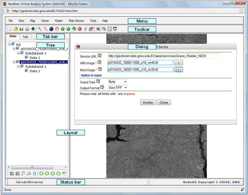
Wikipedia compares features like data retrieval, visual
effects, GUI components, and license of sixteen Ajax
frameworks in one specific table [7]. Chandler Project of non-
profit organization Open Source Application Foundation
(OSAF) also details the description, benefits and drawbacks of
Ajax/JavaScript libraries for developers’ reference [8]. The
selection criteria of Ajax framework for the implementation of
dynamic Web applications should include widget availability,
(1) file size to browser, ease of maintenance and quality of
documentation [9]. In addition, quality of community support,
popularity and performance are also important factors be
considered.
Moreover, AJAX-enabled open source Web mapping
frameworks like OpenLayers and MapBuilder are widely used
to build rich Web-base geographic applications. These
promising geospatial frameworks are compliant with OGC
standards of Web Map Services (WMS), Web Feature Services
(2) (WFS), Web Feature Service - Transactional (WFS-T), Web
Map Context (WMC) and Geography Markup Language
Figure 1. Interaction of Classic HTML and Ajax-driven web application (GML). They also support layers from Google Map and Yahoo
(source: Open Ajax Alliance [4]) Map.
Ajax related websites like AJAXIAN (http://ajaxian.com), All in all, Ajax provides a strong foundation for developing
AJAX.org (http://www.ajax.org) provide Web developers with next generation web geospatial applications. In consideration of
plenty of useful technical documents, JavaScript libraries its advantages and tremendous industry momentum, the
introduction, Ajax related development tools and other helpful GeoBrain development team leverages the power of Ajax to
resources. To accelerate the adoption of Ajax-based Web implement functions of GeOnAS.
technologies, some Ajax vendors (e.g. Microsoft, IBM,
Google, Oracle, Adobe, Eclipse, etc.), open source initiatives III. BUILDING DESKTOP-LIKE GEONAS
and developers founded an organization named Open Ajax
Alliance (http://www.openajax.org/) to offer software Multiple-Protocol Geospatial Client (MPGC) [10], the
community with both technical and marketing fronts [4]. A set predecessor of GeOnAS, was widely installed by GeoBrain
of standard JavaScript functionality has been defined by this project partners and users. However, it was not easily to deploy
organization to solve the interoperability issues which caused and upgrade according to their feedback. So an Ajax-enabled,
by using multiple Ajax libraries [5]. browser-based and desktop-like online geospatial analysis
application is developed to satisfy their requirements and meet
Lawton discusses Rich Internet Applications (RIA) project goal.
development methods including Ajax, Adobe’s Flash,
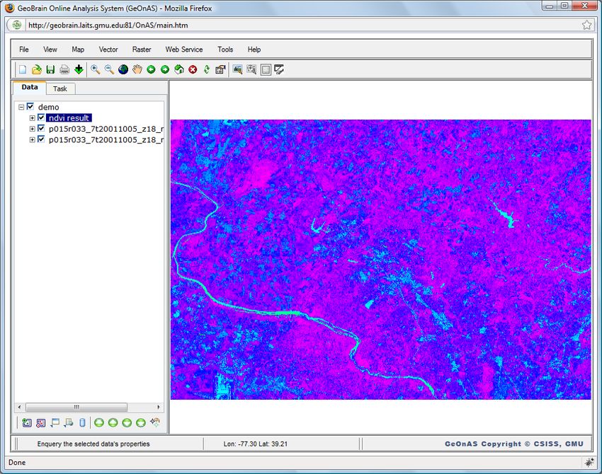
Microsoft’s Silverlight, and Sun’s JavaFX [6]. In comparison Graphical user interface components including Layout,
with other alternatives, Ajax is more stable, viable and Menu, Toolbar, Dialog, Tree, Tab, etc are integrated in
flourishing so far, and presents fewer problems for clients to GeOnAS which looks and behaves more like traditional
use. Windows applications as shown in Figure 2. The appearance
parameters including caption, color, font, position, images and
2.2 Ajax Toolkits/Frameworks tip of these components are loaded from the configuration files
in XML format which are got from server. These components
Ajax frameworks/toolkits provide all the necessary are easily initialized in web page by calling APIs from the
functions for Ajax engine in server-side (e.g. Google Web libraries when user enters GeOnAS.
Toolkit) and client-side (e.g. Dojo toolkit). In GeOnAS, server-
side uses Servlets and Java Server Pages (JSP). Client-side Like those components of desktop software, Layout helps
Ajax frameworks are introduced as follows. developers to define user interface structure, and specify web
page elements along with their sizes programmatically, classic
The browser-side Ajax frameworks provide a set of layout of desktop GIS software is adopted in GeOnAS for
prepackaged controls, components, utilities and JavaScript convenience and consistency; by clicking on text and/or
APIs that help developers to build web sites and applications symbol, Menu/Toolbar offers a quick, direct and flexible
easily and flexibly. A good many of Ajax frameworks are shortcut of execution of each function or command, in response
available for free download and use, and the most favorite ones to the click event of HTML element, associated callback
are ExtJS, Prototype/Script.aculo.us, jQuery, Dojo Toolkit and functions are used to perform an operation; Tree of the map
Yahho! User Interface Library (YUI). These frameworks make layers list allows users to show or hide the selected layer and
the development of RIA much more akin to that of desktop control display order, the tree list is generated dynamically via
applications. calling APIs of Tree component when geospatial dataset being
added, and dataset information is presented in a hierarchical
view; when clicking associated HTML element, popup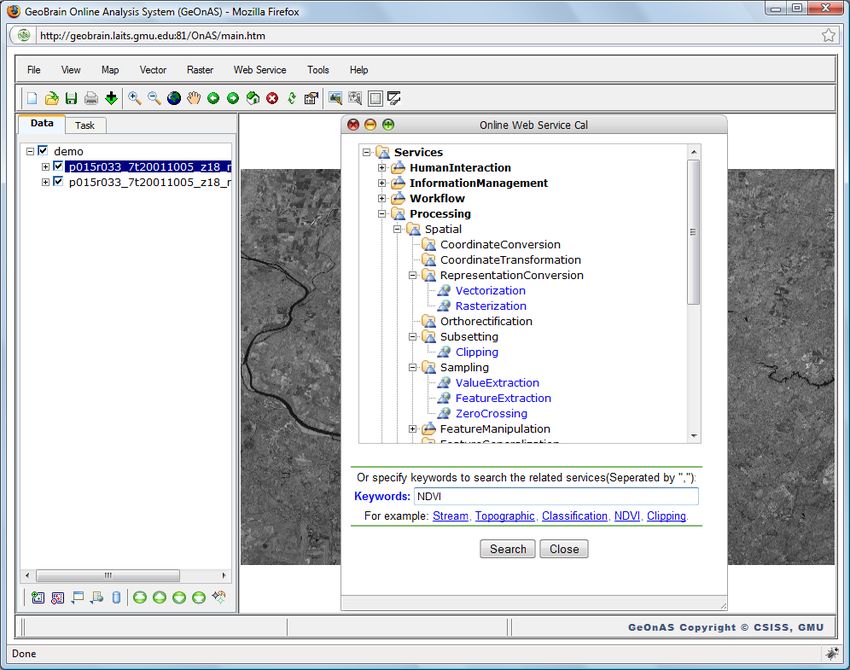
modeless or modal dialog with the content of user choice Geographic Resources Analysis Support System (GRASS) [11]
enables him to input parameter values or specify other or developing new geospatial functions in coordination with
attributes for next operation; Status Bar with three sections project partners. The request and response messages are
displays current state of users operation, mouse position and exchanged in Simple Object Access Protocol (SOAP) format
copyright information; tab is used to switch between the map between the middleware and Web geospatial services. This
layers tree list and the tasks list; Tooltip provide helpful middleware processes the Web services results and return them
information regarding the element which is hovered over by the as the response text of XMLHttpRequest to the browser client
mouse cursor. asynchronously. E-mail is sent to notify the progress or status
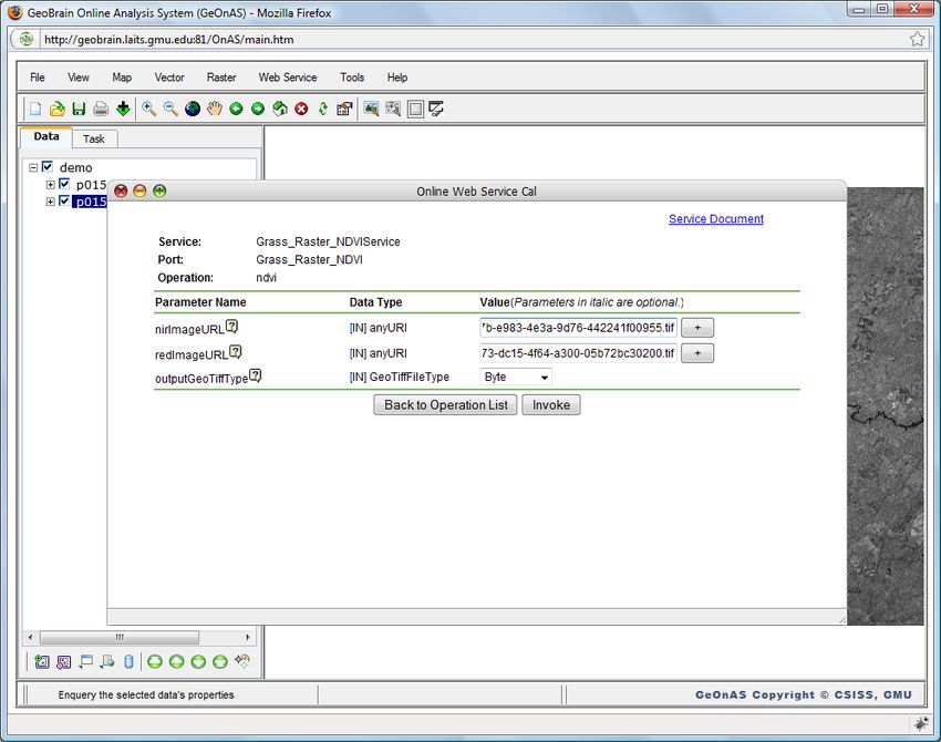
of invocation when user exits GeOnAS. Figure 4 demonstrates
the process of invoking web NDVI services asynchronously via
this middleware and Ajax.
Figure 2. GeOnAS User Interface
Ajax is also used to call functions implemented as Servlets
(1) Search Web NDVI Service
or JSPs in server-side of GeOnAS. For example, it is employed
to obtain the bounding box of specified location and interact
with Google Map when creating new project, as displayed in
Figure 3. GetCounties Servlet is developed to generate the
counties list of selected state of the United States, and
GetBBOX Servlet to obtain the bounding box of specified
location (country, state, or county). When XMLHttpRequest get
the correct response text from these Servlets, the counties list
will be displayed in the dropdown combo box, and the
bounding box values will be shown in text boxes and displayed
in Google Map form.
(2) Input Parameters
Figure 3. New Project Window
Moreover, Ajax is adopted to communicate with Web
Service Caller Client, one middleware package which has been
built to discover, select, and invoke Web geospatial services in
GeOnAS. The GeoBrain team has implemented many Web
(3)Wait Result
geospatial services by wrapping the associated functions from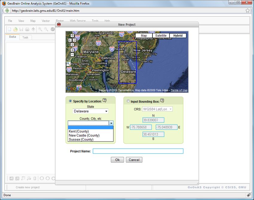
According to the suggested solutions, JavaScript code, CSS
                                                                   and HTML are shrunk by removing all unnecessary spaces and
                                                                   comments from them to optimize network and runtime
                                                                   performance. Obfuscation code (like Google Map) is not
                                                                   adopted in GeOnAS because it changes the names of variables,
                                                                   functions and members to shorter strings that are harder to
                                                                   understand and debug. And JavaScript Packer is selected to
                                                                   decrease file size by compression. The prototype object of
                                                                   JavaScript is involved in improving the modularity of source
                                                                   code. In GeOnAS, WCS, WFS and WMS layer objects are
                                                                   inherited from this object, and attributes/methods could be
                                                                   easily accessed from their instances. Through these
                                                                   optimizations, the overall performance score evaluated by
                                                                   YSlow increased from F(58) to C(74). Plus we will improve
                                                                   those items with poor grade in the Performance Grade table.
                           (4)Add Rseult

                                                                                     V.    LESSONS AND CONCLUSION
                                                                      Lessons learned from the implementation of GeOnAS are
                                                                   summarized as follows:
                                                                       Ajax-enabled application especially online analysis system
                                                                   is difficult to debug and test because of the complex interaction
                                                                   between browser and server. In our development process,
                                                                   Firebug is used as an effective JavaScript debugging tool to
                                                                   find and fix small issues, and JsUnit is employed in unit testing
                                                                   for client-side JavaScript code.
                                                                      A number of Ajax toolkits from open source community
                                                                   provide seamless Ajax features and make it easy to develop
                                                                   Ajax-driven web applications. The adoption of these toolkits
                                                                   saves us considerable time and effort. However, JavaScript
                         (5) Display Result                        conflicts should be pay more attention when using multiple
                                                                   Ajax libraries in the same page. Using namespace is a good
               Figure 4. Web NDVI Service Invocation
                                                                   choice for this.
                                                                       Since various browsers support Ajax differently, developers
         IV.    SYSTEM PERFORMANCE IMPROVEMENT                     should make the implementations and test their accessibility for
   System performance related issues (e.g. network transfer        different platforms and browsers. Currently, GeOnAS is well
time, server response time, and client processing time) should     supported in IE and Firefox, its support for other browsers is
be analyzed carefully when building Web applications with          being tested and validated.
Ajax [12].
                                                                       Concatenating all JavaScript and CSS files into one file
    GeOnAS is deployed in a cluster environment with high          could avoid the costs of multiple HTTP request. We will
speed interlinks which could load balance HTTP requests to         combine the source code following the modularity principle in
achieve high scalability and improve system stability. And we      the near future.
will replace four old Apple Xserve G5 servers with 2GB
                                                                       In addition, enabling gzip is another effective way to reduce
memory and Dual 2G Hz PowerPC 970 processor with four
                                                                   text-based resources of Ajax application. And system security
new Apple Intel Xserve servers with 32GB memory and two
                                                                   of Ajax application should be paid more attention.
2.8G Hz Quad-Core Intel Xeon processors. These devices will
improve server processing speed dramatically.                          In conclusion, AJAX offers GeoBrain users a better
                                                                   interactive, powerful, and responsive web experience, and it
    Although the use of Ajax could leads to better overall user
                                                                   helps this data-rich and service-centric geospatial web
experience, it also could come with downsides. Analysis tools
                                                                   applications be utilized by Geosciences researchers.
like Firebug (a Firefox extension) and Yahoo! YSlow (Firefox
add-on integrated with Firebug) are useful to analyze HTML,
CSS and JavaScript code of GeOnAS and suggest solutions to                                      REFERENCES
improve its performance based on a set of rules for high           [1]   L. Di, P. Zhao, W. Han, Y. Wei, X. Li, "GeoBrain Web Service-based
performance sites [13]. Firebug Lite could be installed in other         Online Analysis System (GeOnAS)", Proceedings of NASA Earth
browsers such as Internet Explorer and Safari to simulate some           Science Technology Conference 2007, College Park, Maryland, USA,
                                                                         2007.
Firebug features.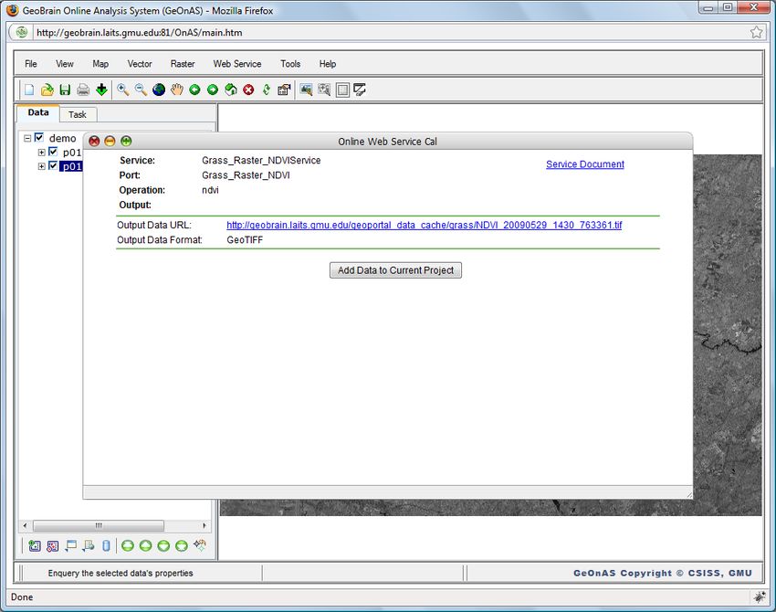
[2]   J. J. Garret, "Ajax: A New Approach to Web Applications",               [8]    Open Source Application Foundation, “Survey of Ajax/JavaScript
      http://www.adaptivepath.com/publications/essays/archives/000385.php,           Libraries”, http://chandlerproject.org/Projects/AjaxLibraries, 2009.
      2005.                                                                   [9]    Turner A., Wang C., Journal D., “Ajax: Selecting the Framework that
[3]   L. D. Paulson, "Building Rich Web Applications with AJAX",                     Fits”, http://www.ddj.com/web-development/199203087, 2007.
      Computer, Vol. 38, No.10, pp. 14-17, 2005.                              [10]   P. Zhao, D. Deng, L. Di, “Geospatial Web Service Client”, Proceedings
[4]   Open Ajax Alliance, “Introcuding Ajax and OpenAjax”,                           of ASPRS 2005 Annual conference, Baltimore, Maryland, USA, 2005.
      http://www.openajax.org/whitepapers/Introducing%20Ajax%20and%20         [11]   X. Li, L. Di, P. Zhao, Y. Wei, W. Han, "Development of GRASS based
      OpenAjax.php, 2008.                                                            Geospatial Web Services", Proceedings of the XXI Congress the
[5]   Open Ajax Alliance, “OpenAjax Hub 2.0 Specification”,                          International Society for Photogrammetry and Remote Sensing, Beijing,
      http://www.openajax.org/member/wiki/OpenAjax_Hub_2.0_Specificatio              China, 2008.
      n, 2009.                                                                [12]   Zyp K. W., “Ajax Performance Analysis”, http://www.ibm.com/
[6]   G. Lawton, "New Ways to Build Rich Internet Applications", Computer,           developerworks/web /library/wa-aj-perform/, 2008.
      Vol. 41, No.8, pp. 10-12, 2008.                                         [13]   Yahoo! Developer Network, “Best Practices for Speeding Up Your Web
[7]   Wikipedia,       “Comparison      of     JavaScript      frameworks”,          Site”, http://developer.yahoo.com/performance/rules.html, 2008.
      http://en.wikipedia.org/wiki/Comparison_of_JavaScript_frameworks,
      2008.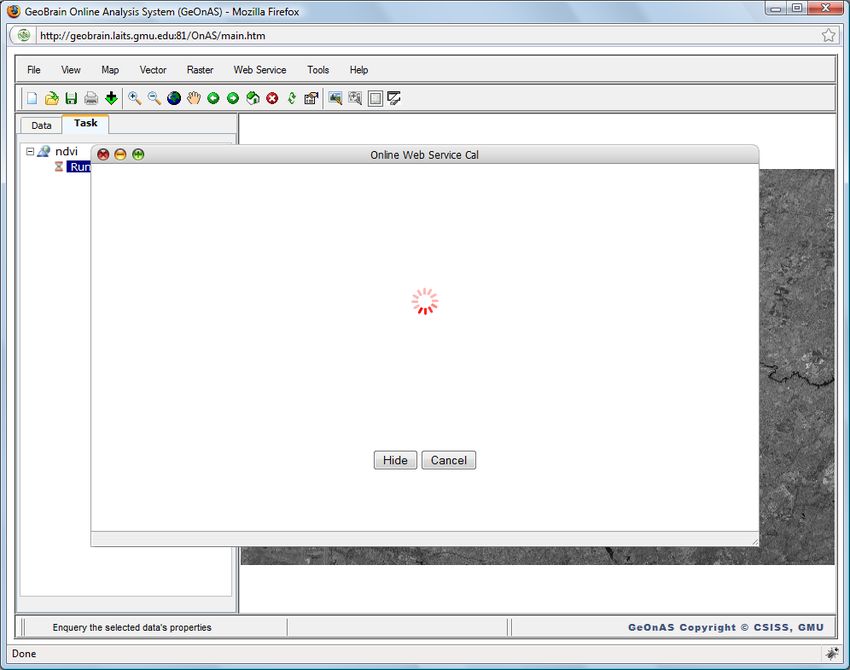
You can also read