Using modern technology to protect vineyards from hail amid climate change
←
→
Page content transcription
If your browser does not render page correctly, please read the page content below
E3S Web of Conferences 234, 00034 (2021)                                                    https://doi.org/10.1051/e3sconf/202123400034
ICIES 2020

    Using modern technology to protect vineyards from hail amid
    climate change
    Teimuraz Davitashvili1*, Inga Samkharadze2, Lika Megreladze3 and Ramaz Kvatadze4
    1Iv.Javakhishvili Tbilisi State University, I.Vekua Institute of Applied Mathematics, 0186, 2, University str., Tbilisi, Georgia
    2Iv.Javakhishvili Tbilisi State University, Faculty of Exact and Natural Sciences, 0143, 1 Chavchavadze ave, Tbilisi, Georgia
    3National Environmental Agency of Georgia, Hydrometeorological Department, 0112, 150, Aghmashenebeli ave., Tbilisi, Georgia
    4Georgian Research and Educational Networking Association GRENA, 0108, 4a, Chovelidze str., Tbilisi, Georgia

                 Abstract. Over the past two decades, Georgia has faced increasingly heavy rainfall, hail and flooding,
                 which especially devastated Kakheti wine region in Southern Georgia, causing severe damage to hundreds
                 of vineyards. Since 2015, 85 anti-hail missile systems have been installed to protect entire Kakheti region,
                 however, for the effective use of a modern anti-hail system, it became necessary to timely forecast extreme
                 weather events of a regional and local scale. Thus, this article aims to develop timely forecasting of strong
                 convection, dangerous precipitation and hail using modern weather forecasting models and radar
                 technologies in Georgia. For this reasons various combinations of the physics parameterization schemes of
                 the WRF-ARW model, the ARL READY system and the data of the modern meteorological radar Meteor
                 735CDP10 are used to predict the thermodynamic state of the atmosphere and assess the possible level of
                 development of convective processes. The analysis of the calculated results showed that the variants of the
                 microphysics parametrization schemes of the WRF model lead to significant variability in precipitation
                 forecasts on complex terrain. Meanwhile, the upper-air diagrams of the READY system clearly showed the
                 instability of the atmosphere for the cases discussed. Some results of these calculations are presented and
                 analysed in this paper.

  1 Introduction                                                       topographic sections) play an important role in formation
                                                                       of 15 local climatic zones in Georgia [3,4]. Indeed,
  Currently, the problem of global climate change is                   Georgia lies between the Black Sea and the Caspian Sea
  directly linked to growing environmental pollution by                (along the Black Sea eastern coast), to the south of the
  anthropogenic waste, the crisis in the field of public               Main Caucasus Ridge and to the north of the Lesser
  health safety (caused by environmental pollution, the                Caucasus Mountains (the Lesser Caucasus Mountains
  outbreak of infectious diseases), the production of high-            occupy the southern part of Georgia). These two
  quality food etc. [1]. For instance, it has become                   mountain systems are linked by the Likhi (Surami)
  apparent that in the context of global and regional                  mountain range, which is located almost along the
  climate change, serious threats arise even for                       meridian and bisects the country into western and eastern
  conventional and basic food production due to increased              parts with different climatic features (see Fig.1).
  rainfall, catastrophic floods, prolonged droughts,
  growing desertification processes and changed duration
  of seasons (in mid-latitudes, summers get hotter and
  winters are colder, the length of spring decreases with
  decreasing temperature, and only the duration of autumn
  increases with warm weather) [2]. Outbreaks of climate
  change, such as increased rainfalls, catastrophic floods,
  hails, are especially noticeable in regions with
  heterogeneous topography [2]. Climate change has not
  bypassed the territory of Georgia, as evidenced by the
  trend towards an increase in average annual temperature
  (with average daily minimum temperature and average
  daily maximum temperature) [2,3]. The geographic                     Fig. 1. A physical map of the Caucasus (Georgia)
  location of Georgia and especially the complex relief
  (about 75% of the 69,700 sq. km total land area occupied                Generally, the territory of Georgia extends from the
  by mountains and mountain ranges with complex                        subtropical zone of the southeast coast of the Black Sea
    *
      Corresponding author: teimuraz.davitashvili@tsu.ge

© The Authors, published by EDP Sciences. This is an open access article distributed under the terms of the Creative Commons Attribution
License 4.0 (http://creativecommons.org/licenses/by/4.0/).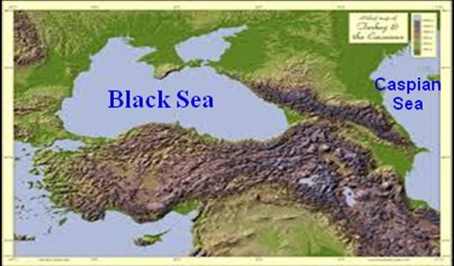
E3S Web of Conferences 234, 00034 (2021)                   ICIES’2020                  https://doi.org/10.1051/e3sconf/202123400034
ICIES 2020

   to the high peaks of the Greater Caucasus and the semi-            hydrometeorological processes and the WRF model for
   deserts of the lowlands in the southeast.                          regional weather forecasting in Kakheti.
       The climate change process and its impact on the
   environment has become more than ever obvious over
   the past decade in Georgia. According to statistics of the         2 Problem statement
   National Environmental Agency (NEA) of Georgia, the                Against the backdrop of the current regional climate
   frequency of natural disasters in recent decades has               changes, heavy rains with hails, often accompanied by
   increased significantly, namely heavy rains increased              floods and landslides (more often than usual in
   with dramatic consequences, which undoubtedly is                   mountainous areas), in most cases led to serious losses of
   associated with climate change [3]. Heavy rains, hail,             both lives and infrastructures [1, 9]. It is obvious that
   floods and drought are the main climatological hazards             timely forecasting of such events is an important step to
   for the country [5-7]. It is reported that floods kills more       avoid or minimize the effects of disasters. Over the past
   people, but droughts affect far more number of people              two decades, Georgia has been increasingly confronted
   and causes more economic damage in Georgia. For                    with heavy rainfalls, hails and floods, which have
   example, a severe drought in 2000 affected about                   especially devastated Kakheti wine region causing
   700,000 people and caused damage of 5.6% of GDP due                serious damage to hundreds of vineyards [9]. Wine
   to its impact on agriculture and hydropower production             production occupies one of the main places in the
   [8]. The same applies to natural disasters such as                 Georgian agricutlural economy there has been a
   landslides, avalanches and tornadoes indicating climate            continuous tradition of winemaking in Georgia for 8,000
   change [3,6,7]. During the last four decades the number            years     http://www.natenadze.company        /history-of-
   of natural hazards in comparison to 60th years of the last         georgian-wine.html. By order of the Georgian
   century has increased about three times and as a                   government in Kakheti, anti-hail rocket launchers (one
   consequence economic expenses have increased eight                 for every 10 km) were installed to protect the entire
   times [2, 9].                                                      region [10]. However, for the effective use of anti-hail
       Within the last decades seasonal changes have also             rocket launchers, the need arose to timely predict
   been evident, as the desertification process, which has            extreme weather events of regional and local scale.
   become apparent in Southeastern parts of Georgia. In               Therefore, the urgent issue is the timely forecasting of
   addition, climate change on the territory of Georgia is            strong convection, hazardous precipitation and hail using
   manifested well against the background of accelerated              modern weather forecasting models and radar
   melting of Georgian glaciers, an increase in the number            technologies in Georgia.
   of droughts, showers and hails [2,4,10]. Studies on the
   intensity of the formation of hazard showers, hails and
   floods against the backdrop of modern climate change in            3 Anti-hail service in Eastern Georgia
   Eastern Georgia were conducted for the period of 1921-             (Kakheti)
   2000. The analysis showed that the frequency of
   recurrence of hazard floods for the period of 1961-2000            Eastern Georgia is one of the hail-dangerous parts of the
   compared to the period of 1921-1960 increased by 150%              world and therefore, numerous works (theoretical and
   in Eastern Georgia [6,8,9]. Among them, extremely                  industrial) have been devoted to the problem of action on
   heavy rainfall with hail increased by 12%, and there are           hail processes [10,11]. Given the significant economic
   no reliable methods for prediction these dangerous                 damage caused by hails in Georgia, pilot industrial and
   natural phenomenas even for short periods of time [3,7].           production works were carried out to combat hail
   Especially over the past two decades, the number of                (Kakheti - 800 thousand hectares, Southern Georgia -
   showers with hail (as a result of floods and landslides)           400 thousand hectares) on the basis of the Alazani anti-
   has increased in Eastern Georgia [5,10]. Currently,                hail expedition in 1960-1990 [10, 12]. It should be noted
   climate change is seen as a serious environmental issue,           that crystallization reagents (AgI, PbI2, NaCl) were used
   and also poses an additional risk to political stability in        in almost all studies, and the positive effects of the
   the Caucasus region.                                               Alazani anti-hail system varied between 20–95% with an
       The purpose of this article is to discuss anti-hail            average value of 75–85% [10]. In the Soviet period,
   operations for the safety of vineyards amid regional               along with anti-hail operations, other works were carried
   climate change in Kakheti region of Georgia. Namely, in            out in Georgia, such as artificial precipitation, and the
   2015 in Kakheti, on an area of 650 thousand hectares,              regulation of thunderstorm activity of clouds, using
   work of counteracting the hail was resumed using a                 rocket, aviation, artillery and other devices and methods
   modern anti-hail system. The processes of radar                    [11, 13]. In 1989, work against hail were discontinued,
   observation of a hail of clouds in Kakheti and missile             and as a result, in subsequent years, damage to the
   strikes against them are carried out using modern                  national economy increased significantly [10–13]. It was
   meteorological radar and rocket installations with remote          revealed that the areas beaten by the hail in Kakheti
   control from Tbilisi. In order to increase the level of            increased over the years after the reduction of anti-hail
   protection against hail, the methodological and                    operations and even became larger than before the start
   technological components of the anti-hail system are               of the anti-hail service [14,15].
   constantly being improved. In this article, in addition to             Given the importance of anti-hail work, with the
   preventing hail, anti-hail missiles are proposed to use the        support of the Government of Georgia, the active work
   ARL READY System, a radar for monitoring dangerous                 of the Delta Scientific and Technical Center and the

                                                                  2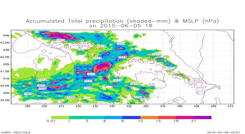
E3S Web of Conferences 234, 00034 (2021) ICIES’2020 https://doi.org/10.1051/e3sconf/202123400034
ICIES 2020
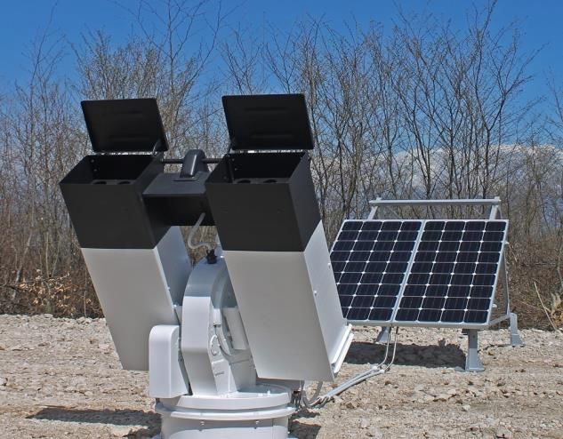
cooperation of the Institute of Geophysics and the (Fig. 2) is an unguided 55-mm rocket that carries 40 g of
Institute of Hydrometeorology, the work of the anti- hail silver iodide and disperses it at the altitudes of 2.0-4.5
service in Kakheti on May 28, 2015 was restored [10]. km for 28-32 seconds [17]. For protection of the entire
Protection from hail is being carried out in almost 50 region of Kakheti, it is necessary to place 85 launch
countries of the world (Argentina, Austria, Bulgaria, points - one for every 10 km, which is a working ground
Canada, China, Bosnia and Herzegovina, Germany, for the anti-hail rocket. A rocket launcher, a solar
Greece, Macedonia, Moldova, Romania, the Russian battery, grounding and safety systems are installed to the
Federation, Serbia, Spain, etc.). For example, in China, launch pad. The launcher carries 26 anti-hail missiles
anti-hail operations are carried out on the territory of 42 aimes to shoot at any direction [10, 17]. From 2015 to
million ha, and in the Russian Federation - on the August 2016, it was possible to use SK-6 anti-hail
territory of 2.5 million ha [10,11,16]. In Kakheti, the missiles manufactured by Macedonia. From September
effectiveness of anti-hail operations depends on the total 2016 to August 2018, hail-emitting anti-hail missiles
aerosol pollution of the atmosphere (optical depth of the "Trayal D 6-B" manufactured by Serbia were used, and
aerosol and atmospheric turbidity coefficient, from September 2018 to present anti-hail missiles "Loza-
respectively) [10]. Statistical analysis of historical data 2" made in Bulgaria are being used [18]. In general, the
on precipitation and aerosols showed that aerosols can characteristics of the Loza-2 missiles are slightly better
affect deeper clouds of precipitation in the form of than the Tra-D-6B, but it should be noted that both types
sediment suppression [16]. In particular, the suppression of missiles are characterized by insufficient length of the
effect is stronger in the mountains than over the plains sowing line and about 5000-6000 units are necessary for
[5], and the influence of anthropogenic aerosols on one year that costs quite expensive to the state [19].
convective precipitation may play an important role in
summer over Kakheti as well [6,7]. 4 Hail predictions using various physics
The new Anti-hail system in Kakheti consists of: options of WRF model
Contemporary weather radar Meteor 735CDP10 which is
a C-band, dual polarized Doppler radar, generating all
Hail is often associated with the presence of deep
the data to forecast hail-producing thunderstorms;
convection against a background of complex orography
Central control station with the automatized fire control
and earth cover. To simulate such smaller scale
system (85 rocket launching sites); the autonomous
convective atmospheric processes and its main
automated rocket launching device SD-26 and SD-52
characteristics it becomes necessary to take into account
and anti-hail rocket (Fig.2); scientific group and the
local features of the relief, atmospheric stratification and
group of the maintenance of radar and rocket guns [10].
the influence of large-scale atmospheric processes. It
should be noted that in addition to this, forecasting short-
term, summertime heavy rainfall with hail using
numerical models is a difficult task, especially in
mountainous regions with complex orography [20-22].
The Weather Research and Forecasting (WRF) models
are widely used by many operational services to predict
regional weather [23].
In fact, the Advanced Research Weather Research
and Forecasting Model (WRF- ARW) is a convenient
tool for conducting both research and operational works,
as it contains a large number of physics options that can
be combined in various ways [24]. Indeed, in the WRF-
ARW model, the main categories of physics
parameterization (microphysics, cumulus
parameterization, surface physics, planetary boundary
layer physics and atmospheric radiation physics) are
Fig. 2. The automated launching device SD-26.
interconnected through the model state variables
(potential temperature, humidity, wind, etc.) and their
All information from weather radars and missile tendencies [23,24]. Among these parameterization
launch sites is collected at the central control station in scenarios, it is not easy to determine the correct
Tbilisi. This information is processed, and then the combination which better describes the meteorological
automated fire control system receives data and sowing phenomenon that dominates the region under study. Our
zones from special meteorological radar software, aim is to identify the best combination of
determines the optimal launch location, the required parameterizations in the WRF model over the specific
number of missiles and sends orders to the appropriate study area.
launching devices. The work of the anti-hail service is
supported by the scientific organizations - Institute of 4.1 WRF model simulation design
Geophysics, Institute of Hydrometeorology, etc., which
modify the scientific methods of work management [10]. In our study, we have used one-way nested domains
The anti-hail rocket SK-6 manufactured by Macedonia centered on the territory of Georgia. The coarser domain
3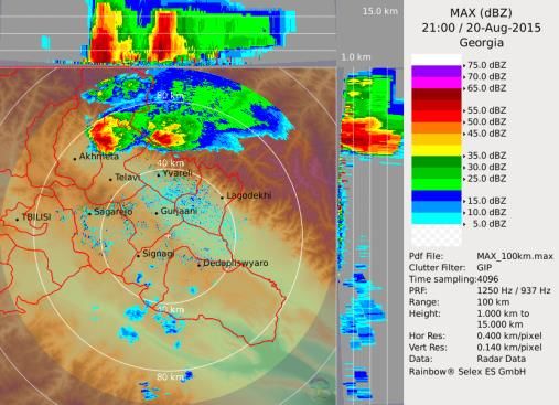
E3S Web of Conferences 234, 00034 (2021)                           ICIES’2020                https://doi.org/10.1051/e3sconf/202123400034
ICIES 2020

   (resolutions of 6.6km) has a grid of 94x102 points which                20-21 August 2015 on the territory of Georgia were
   covers the South Caucasus region. While the nested                      investigated. For example weather on June 5, 2015 in
   inner domain (resolutions 2.2 km) has a grid size of                    Eastern Georgia (Gori, Dusheti, Akhmeta) was
   70x70 points mainly on the territory of Georgia. Both                   extremely bad with showers, hail and flood (Fig.3). At
   use the 54 vertical levels including 8 levels below 2 km.               17:00 cloudy system in the form of atmosphere front
   A time step of 10 seconds was used for the nested                       moved in Georgia from south-west to the east with
   domain. The WRF model contains a number of different                    velocity 20-25m/s. According to weather Radar at 17:45
   physics options such as microphysics (MP), cumulus                      part of the cloud system reached Tbilisi and the
   parameterization (CPs), radiation, surface layer, land                  remainder part moved towards the Kakheti region
   surface, and planetary boundary layer physics.                          (Akhmeta) where height of the clouds system was about
   Microphysics contains a number of MP modules and in                     16 km and reflecting state-55 db.
   our study we have chosen WSM6, Thompson, Purdue
   Lin, Morrison 2 Moment and Goddard schemes.
       Cumulus parameterization schemes are responsible
   for the sub-grid-scale effects on convective and/or
   shallow clouds and theoretically valid only for coarser
   grid sizes [23]. We have chosen Kain-Fritsch, Betts –
   Miller - Janjic and Grell – Devenyi ensemble schemes
   for our experiments. The planetary boundary layer (PBL)
   is responsible for vertical sub-grid-scale fluxes due to the
   eddytransports in whole atmospheric column [23].
   Parameterization of the PBL directly influences vertical
   wind shear, as well as precipitation (hail) evolution [23].
   There are number of PBL schemes but according to [23]                   Fig.3 After hail in Kakheti (Akhmeta) on June 5 2015
   we have chosen Yonsei University scheme. The land-
   surface models use atmospheric information from the                         Results of calculations performed by Set 1 gave the
   surface layer scheme, radiative forcing from the                        better results than other combinations and accumulated
   radiation scheme, and precipitation forcing from the                    total precipitations in Gori (41.7° N, 44.6 ° E) and hail in
   microphysics and convective schemes. Together with                      Akhmeta (42.0385° N, 45.2068° E) were predicted
   internal information on the land’s state variables and                  satisfactorily (see Fig.4)
   landsurface properties, to provide heat and moisture
   fluxes over land points and sea-ice points [23] were
   used. We have chosen Noah Land Surface Model. After
   considering various combinations of MP, CPs, Land
   surface-physics and planetary boundary layer physics its
   combination for our experiments are given in the Table
   1.
     Table 1. Five set of the WRF parameterizations used in this
                               study.

      WRF        Set1     Set 2    Set 3    Set 4        Set 5
      Physics
      Micro      WSM      Thom     Purdu    Morrison     Goddard
      physics    6        pson     e Lin    2-Moment
      Cumulus    Kain-    Betts-   Kain-    Grell-       Kain-             Fig. 4. Accumulated total precipitation (2 h sum) at 18:00 on
      Paramete   Fritsc   Miller   Fritsc   Devenyi      Fritsch           June 5 simulated by the nested domain with 6.6 km resolution.
      rization   h        Janjic   h        ensemble
      Surface    MM5      MM5      MM5      (PX)         MM5                   In addition, strong hail and wind destroyed dozens of
      Layer      Simil.   Simil.   Simil    Similarity   Similarit
                                                                           hectares of vineyards, watermelons and corn gardens in
      Planet.    YSU      YSU      YSU      ACM2         YSU
      Boundar    PBL      PBL      PBL      PBL          PBL               the main wine-growing region Kakheti on July 22, 2015
      y Layer                                                              due to the atmospheric front of occlusion with the
      Land-      Noah     Noah     Noah     Noah         Noah              processes of internal air mass. At 19:00 a strong cloud
      Surface    LSM      LSM      LSM      LSM          LSM               system formed over the cities of Akhmet and Telavi
      Atmosph    RRT      RRT      RRT      RRTM/D       RRTM/             (41.9185 ° N, 45.4777 ° E) with a height of 15-16 km
      eric       M/Du     M/Du     M/Du     udhia        Dudhia
      Radiat.    dhia     dhia     dhia                                    and a reflective state of 60-65 dB. The results of
                                                                           calculations performed using Set 1 and Set 5 gave better
                                                                           results than other combinations. Set 5 with a resolution
   5 Results and Discussions                                               of 6.6 km was able to simulate the total precipitation in
                                                                           Dusheti and Akhmet, however, analysis of the results of
   Four particulate cases of unexpected heavy showers with                 calculations performed using a fine grid (2.2 km)
   hail which took place on 5 June, 13-14 June, 22 July and                improved the quality of the ATP forecast (see Fig. 5).

                                                                       4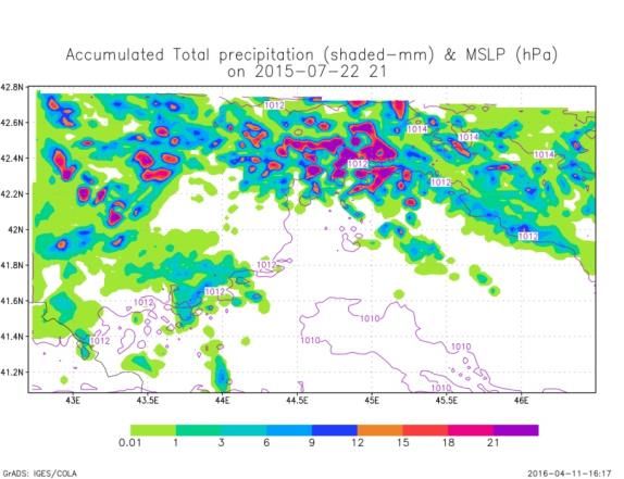
E3S Web of Conferences 234, 00034 (2021)                     ICIES’2020                   https://doi.org/10.1051/e3sconf/202123400034
ICIES 2020

                                                                        Chem and WRF Climate models above the Caucasus
                                                                        territory.
                                                                            Currently, the use of the radiosonde is associated
                                                                        with some financial costs, and in some developing
                                                                        countries it is practically not used (among them
                                                                        Georgia). In order to efficiently and timely forecast
                                                                        current atmospheric processes, the Air Resources
                                                                        Laboratory (ARL) of the National Oceanic and
                                                                        Atmospheric Administration (NOAA) has created a
                                                                        Real-Time Environmental Application and Display
                                                                        System (READY, http: // www.ready.noaa.gov). The Air
                                                                        Resources Laboratory (ARL) of the National Oceanic
                                                                        and Atmospheric Administration (NOAA) built
                                                                        aerological charts using an environmental application
                                                                        system and real-time display systems with a horizontal
  Fig. 5. ATP (2 h sum) forecast using 2.2 km resolution at 21;00
  on 22/07/2015 by Set 5                                                resolution of 0.5 latitude. However the numerical value
                                                                        of the instability power and convective braking power is
      Another case of severe convective events was                      estimated using the system READY. ARL with a
  observed on August 20-21, 2015 in Kakheti. The western                horizontal resolution of 1.0 latitude (~ 111 km)). All
  atmospheric process prevailed from August 19 to 21                    meteorological forecast data available through READY
  over the territory of Georgia. It was proclaimed on the               comes directly from NCEP and includes a wide range of
  evening of August 19 in Kakheti. On August 20 heavy                   scales. Global Forecast System (GFS) model with
  rainfall over Kakheti was observed again (see Fig.6).                 horizontal resolutions of 0.5 and 1.0_ latitude (~ 111
  Namely, rain and hail caused by stormy weather lasted                 km), 3 km high resolution fast update model (HRRR)
  half an hour, broke the roofs and even the walls of the               covering the lower 48 states, and NAM Fire Weather
  houses of Gurjaani, Lagodekhi and Kvareli. About 95%                  Nest jack that moves to a new place when there is a need
  of the grapes were destroyed by hail in the Lagodekhi                 for detailed meteorological forecast data. The finished
  and Kvareli districts.                                                ARL NOAA system also has an archive of
                                                                        methodological data, including HRRR, NAM, NAM
                                                                        Data Assimilation System (NDAS), Global Data
                                                                        Assimilation System (GDAS) and NCEP / National
                                                                        Atmospheric Research (NCAR) reanalysis data.
                                                                            In order to assess the thermodynamic state of the
                                                                        atmosphere for the extreme days discussed in this article,
                                                                        we used the READY System archive [25]. We compared
                                                                        the obtained results to the obtained real data from the
                                                                        Signagi meteorological radar. Aeorological diagrams for
                                                                        discussed cases precisely showed instability of
                                                                        atmosphere on local territory despite the fact that in all
                                                                        four cases we had different levels of instability. These
                                                                        differences corresponded to real meteorological
                                                                        condition of specified day (according to the data of
                                                                        meteorological radar). According to the obtained results
  Fig. 6. Meteorological radar Data 21:00 on Aug.20 2015                it can be stated that under the basis of analysis of
                                                                        forecast aeorological data availabe for specific regions
  Comparison of the results of the numerical calculations               through READY System of ARL of NOAA it is possible
  performed by Set 3 and Set 5 showed that the main                     to forecast thermodynamic condition of atmosphere.
  characteristics of the ATP were predicted almost equally              Also evaluation of possible development level of
  well, but a detailed analysis and its comparison with the             convective processes on local territory together with
  meteorological radar data showed that in this case, Set 3             forecasting methods of forecasting operative office for
  gave better results than set 5 (see table 1). Thus,                   the weather of Georgia will improve the level of
  comparisons among WRF forecasts allowed verifying                     forecasting.
  that in general the Kain-Fritsch scheme in combination
  to WSM6, Purdue Lin and Goddard schemes gave better
  results than others, for western atmosphere processes                 6 Conclusions
  dominated above the territory of Georgia. Also for
  evolution and improvement of model skills for different               Currently, heavy rains with hail (often accompanied by
  time and spatial scale the verification and assimilation              floods and landslides) in most cases lead to serious loss
  methods should be used for further tuning and fitting of              of vineyards in many regions of the earth. Therefore,
  model to local conditions. Also it can be said, that above            timely forecasting of such strong convective phenomena
  mentioned model in some combinations of physics                       using modern technologies is an important task. This
  options can be successfully used as a basis for WRF                   article aims to develop a forecasting approach using the

                                                                    5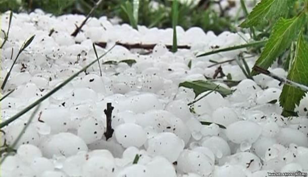
E3S Web of Conferences 234, 00034 (2021)                  ICIES’2020                  https://doi.org/10.1051/e3sconf/202123400034
ICIES 2020

   WRF model, ARL READY system and meteorological                    12. A. Amiranashvili, U. Dzodzuashvili, J. Lomtadze, I.
   radar to study the thermodynamic state of the                         Sauri, V. Chikhladze Trans. of Mikheil Nodia
   atmosphere in Georgia. The analysis of WRF                            institute of Geophysics, v. LXV, Tbilisi, (2015,)
   calculations performed for four cases of heavy showers            13. A. Amiranashvili, M. Bakhsoliani, N. Begalishvili,
   with hail made it possible to test the best combinations              et al Trans. of the Inst. of Hydrometeor. of Acad. of.
   of parametrization schemes for microphysics and                       Sc. of Georgia, 108, (2002)
   cumulus clouds of the WRF-ARW model in the difficult              14. O. Varazanashvili, N. Tsereteli, A. Amiranashvili, et
   terrain of Georgia. It was found that in cases where the              al., Natural Hazards, 64, 3,( 2012)
   regional WRF model is not able to predict local, short-           15. A. Amiranashvili, V. Amiranashvili, R. Doreuli, T
   term, severe weather convective events [6], the upper-air             Khurodze., Yu Kolesnikov. Some Characteristics of
   diagrams of the READY system clearly show the                         Hail Processes in the Kakheti Region of Georgia,
   instability of the atmosphere. Hence to improve the                   Proc.13th Int. Conf. on Clouds and Precipitation,
   safety of vineyards, it is advisable to use in conjunction            Reno, Nevada, USA, August 14-18, v.2, (2000)
   with the WRF model, the READY system and                          16. X. Guo, D. Fu, X. Li, Z. Hu H. Lei, H Xiao, Y.
   meteorological radar.                                                 Hong. Advances in Atmospheric Sciences, 32(2),
                                                                         (2015)
   This research was supported by the Shota Rustaveli National       17. http://delta.gov.ge/en/product/anti-hail-system/
   Science Foundation Grant FR2017/FR17-548. Also the authors        18. Rocket “Loza-2” Specification. STROYPROJECT
   would like to thank Dr. N. Kutaladze and Mr. G. Mikuchadze            LTD, Bulgaria, (2018)
   for putting WRF model at our disposal.                            19. A.G. Amiranashvili, V. A. Chikhladze, U.V.
                                                                         Dzodzuashvili, I. P. Sauri, Sh.O.Telia. J. of the
   References                                                            Georgian Geoph. Soc., 22(1), (2019)
                                                                     20. T. Davitashvili, Z. Khvedelidze, A. Khantadze, K.
                                                                         Tavartkiladze, I.Samkharadze, Trans. of the Instit. of
   1.  IPCC. Climate Change 2007: Synthesis Report.
                                                                         Hydrometeorology 115, (2008)
       Pachauri, R.K. and A. Reisinger (eds.), Contribution
                                                                     21. T. Davitashvili, A. Khantadze, On climate,
       of Working Groups I, II and III to the Fourth
                                                                         desertification and water pollution problems for the
       Assessment. Report of the Intergovernmental Panel
                                                                         territory of Georgia Netherlands: Springer-Verlag,
       on Climate Change. Geneva, Switzerland. (2007)
                                                                         ,(2008)
   2. M. I. Westphal, M. Mehtiyev M. Shvangiradze V.
                                                                     22. T. Davitashvili, R. Kvatadze, N. Kutaladze, Weather
       Tonoyan, Regional Climate Change Impacts Study
                                                                         Prediction Over Caucasus Region Using WRF-ARW
       for the South Caucasus Region, 63, (2011)
                                                                         Model, MIPRO, 2011, Proceedings of the 34th
   3. Second National Communication to the United
                                                                         International Convection, Opatija, Croatia, (2011)
       Nations Framework Convention on Climate Change;
                                                                     23. W. C. Skamarock, J. B. Klemp, J. Dudhia, D. O.
       Ministry of Environment Protection and Natural
                                                                         Gill, D. M. Barker, W. Wang, J.G. Powers, A
       Resources, Republic of Georgia., www.unfccc.int,
                                                                         description of the advanced research WRF Version
       (2009)
                                                                         2. NCAR Tech. Notes. Natl. Cent. for Atmos. Res.,
   4. Sh. Javakhishvili. Georgian Climate Description by
                                                                         Boulder, Colorado. (2005)
       the Months. Tbilisi., (1988).
                                                                     24. Z. T. Segele, Lance M. Leslie and Peter J. Lamb,
   5. T. Davitashvili, N., Kutaladze R. Kvatadze et al.,
                                                                         Tellus A, 65, (2013)
       Effect of dust aerosols in forming the regional
                                                                     25. G. Rolph, Ar. Stein, B. Stunder. Real-time
       climate of Georgia. Scalable Computing: Practice
                                                                         Environmental Applications and Display sytem:
       and Experience, 19 (2), 2018
                                                                         READY Environmental Modelling & Software. 95
   6. T. Davitashvili, On Some Aspects of Climate
                                                                         (2017)
       Change in Georgia, International Journal of Energy
       and Environment, 12, (2018)
   7. T. Davitashvili. Modelling transportation of desert
       dust to the South Caucasus using WRF Chem
       model, E3S Web of Conferences 99, 03011, CADUC
       2019, (2019)
   8. Third National Report of Georgia on IUNCCD,
       Tbilisi, (2006)
   9. SNCU NFCCE, Georgia, (2009)
   10. A.G. Amiranashvili, V.A. Chikhladze, U.V.
       Dzodzuashvili, N. Ya. Ghlonti, I. P. Sauri, J. of the
       Georgian Geoph. Soc., Iss. B.18B, (2015)
   11. N. Bibilashvili, A. Kartsivadze. The Principal basic
       and principles of hail processes modification, 4th
       WMO Scient. Conf. on Weather Modification.
       WMO/IAMAP Symposium, Honolulu, Hawaii,
       USA, (1985)

                                                                 6
You can also read