USING THE EARTH IMAGERY REVOLUTION TO SAVE WILDLIFE - Ditchley Foundation
←
→
Page content transcription
If your browser does not render page correctly, please read the page content below
USING THE EARTH IMAGERY REVOLUTION TO SAVE WILDLIFE.
A new approach to sharing Earth Observation data could help save large
animals. In the midst of the digital age, we have access to imagery data of the
earth's surface of unprecedented quality. The use of these data and the
development of technology like artificial intelligence could provide important new
ways to protect wildlife.
Linwood Pendleton1,2,3,4, Emilio Guirado2,7, Benedicte Madon,2 Domingo Alcaraz-Segura5, Siham Tabik5,
Aurelie Shapiro6, Robin Naidoo, Colby Loucks, Wendy Elliott, Dave Thau
1. World Wildlife Fund, Global Science, Washington DC, USA
2. Ifremer, CNRS, UMR 6308, AMURE, IUEM University of Western Brittany, Plouzané, France
3. Global Change Institute, University of Queensland, Brisbane, QLD, Australia
4. Duke University, Durham, NC, USA
5. University of Granada, Spain
6. World Wide Fund for Nature, Space + Science, Berlin, Germany
7. Multidisciplinary Institute for Environment Studies "Ramon Margalef”, University of Alicante, Spain
A recent report by the Intergovernmental Science-Policy Platform on Biodiversity and
Ecosystem Services (IPBES) shows that the Earth is losing biodiversity at an
unprecedented rate1. Megafauna – the world's large charismatic species – have
historically been particularly vulnerable to dramatic decline and extinction2. Over the last
few hundred years, humans have been a leading cause of decline in megafauna3.
Some megafauna, like elephants and whales, have fallen4 prey to poaching or over-
harvesting. Other megafauna, including smaller marine mammals have been captured
for aquaria, zoos, and parks. Beluga whales were recently shown by National
Geographic to be trapped in cages while waiting for export to aquaria and marine
parks5. Still other megafauna species (e.g. big cats, giraffes, polar bears, North Atlantic
right whales) are disappearing due to less malign, but equally lethal human-induced
threats including habitat loss and fragmentation, pollution, climate change impacts, and
new rapidly increasing threats such as collisions with ships, trains, and vehicles due to
development and economic growth6,7.
For many of the world’s large animal species, our knowledge is limited: many
megafauna species live in remote places such as polar regions, wilderness areas, and
the high seas. Our understanding of these species, our awareness of human impacts on
them, and our ability to monitor the health and well-being of individuals and populations
have been impaired due to this remoteness – we simply do not know where many
megafauna are. Historically, megafauna have been observed through patient and
sometimes expensive watching and tracking – on foot, by plane and helicopter, using
binoculars and hiding in blinds. The previously mentioned imprisonment of beluga
whales was documented by direct video footage. Recently, camera traps, satellite
tagging, acoustic methods, and drones have helped us gain further knowledge of the
presence of many megafauna species (e.g. Dugong Detector, WILDME, SnotBot). But
the world is a big place and the spatial coverage of even these more modern
1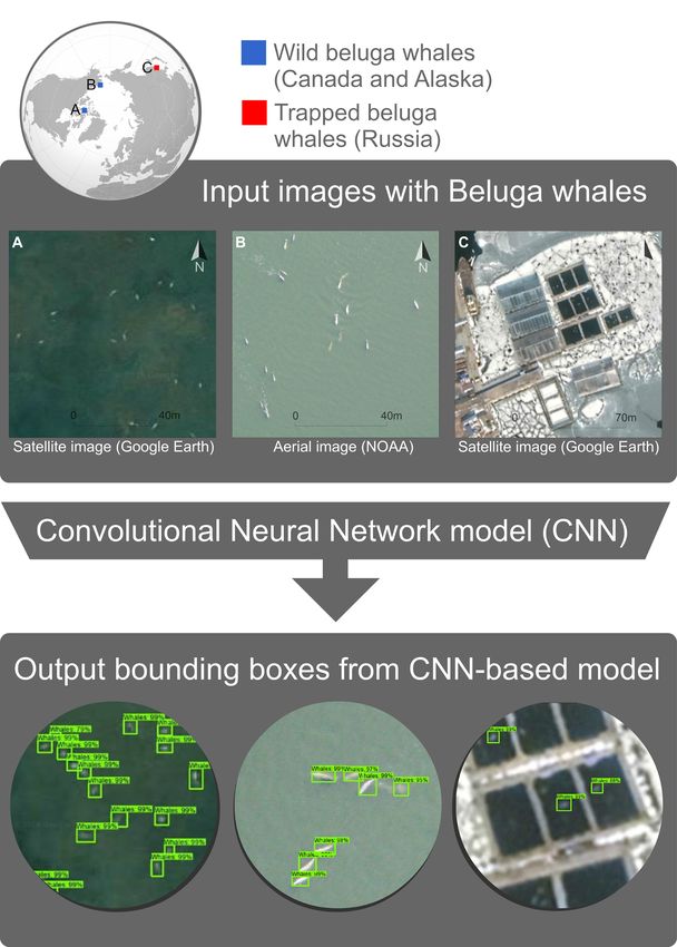
approaches still accounts for only a small proportion of the Earth’s surface; only a tiny
fraction of the world’s megafauna are regularly tracked.

Today, a revolution in earth observation, especially very high-resolution satellite
imagery, could potentially revolutionize our understanding of megafauna, especially
their distribution, and our ability to observe human-megafauna interactions, including
illegal activity. Very high resolution images of most of the Earth’s surface are now
available that could be used to create a photographic evidence-base of wildlife. Most of
these new images are generated and provided increasingly by the private sector
companies (e.g. Maxar, PlanetLabs) that need to cover the numerous costs associated
with launching and maintaining satellites, processing and archiving data, and then
serving these data to those that can pay or in limited cases for development aid or to
respond to natural disasters. Only a small proportion of these images are shared freely,
on platforms such as Google Earth and Maps, Microsoft Bing Maps, and Wikimapia.

Democratizing Wildlife Data

Because the price of accessing very high-resolution satellite imagery can be high8,9 , a
digital divide is emerging between those that can afford to access and use these images
and those that cannot. Businesses and some governments have the financial and
technical resources to now make use of these remote images. NGOs also have
benefited from direct donations of imagery from certain companies (e.g. Planet Open
Region Initiative, SPOT World Heritage, DigitalGlobe Foundation, the European Space
Agency now makes available data from Worldview 1, 2, and 3) and some even have
budgets dedicated to acquiring such images. Nevertheless, these efforts are in often in
parallel, with license restrictions for sharing data between agencies, hindering a
collective effort. There still exist a number of local stakeholders, cash-strapped wildlife
agencies, and smaller not-for-profit conservation organizations that may be effectively
excluded from accessing and examining these images on their own, or via donations.
For those that fear the misuse that could result from the open publication of wildlife
data, such a cost barrier may appear to protect these threatened and endangered
species. Nevertheless, more open and transparent of information about wildlife would
likely improve many types of wildlife management, provided sufficient thought is given to
ethical oversight and metrics10. In a recent study designed to examine whether wildlife
data should be shared, the authors found that a basic decision tree almost always
favoured data publication11.

While scholars and conservationists continue to argue about the virtues and risks of
sharing wildlife data, the digital revolution may make this point somewhat moot12. An
increasing number of Earth observation images are already available to the public for
viewing through platforms like Google Earth, Bing, and Google Maps13 and many more
are available through pay-for-use sites like GBDX and EarthExplorer. This new wealth
of Earth observation images includes those from satellites, new low-orbit cube satellites,
and even more high resolution photographic images uploaded by professional and
amateur photographers (Fig. 1). Already, these images have been used to help map
critical ecosystems (e.g. mapping California’s estuarine systems to support ecosystem-

2
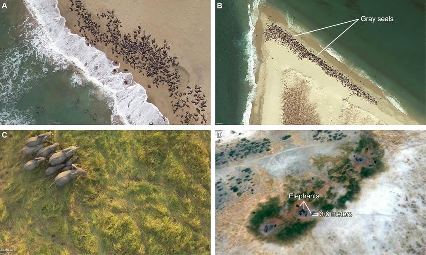
based management, NOAA’s Office for Coastal Management14, and to demonstrate the impacts of human activities on wildlife (e.g. human encroachment on wildlife corridors and the intact forest15, palm oil field expansion16). This proliferation of global Earth imagery, however, could be made much more effective for managing wildlife17,18 if it were better organized, more freely accessible, and made easier to annotate and analyse. Until recently, it was difficult to find wildlife in these images. While literally in near-plain sight for all to see, megafauna in these images are often difficult to discern with the naked eye and difficult if not impossible to find and locate due to the immense number of images and relatively very small size of these animals compared to the large areas covered by the images. To be useful for conservationists, wildlife managers, and law enforcement, these trillions of images (and terabytes of data) must be searched regularly and completely and the megafauna detected. In addition, conservation scientists have used tracking technology for specific species, mapping movements of wildlife over time. These data can be coupled with earth observation to better target where high resolution imagery should be tasked, or where archive imagery should be mined. Fig.1- Aerial (left) and satellite (right) images freely available on Google EarthTM. A) Sea lion colony at North of Cape Cross in Namibia. B) Gray seal colony in Nantucket National Wildlife Refuge in Massachusetts. C) Elephants in Zakouma National Park in Chad. D) Elephants in CT/1 Concessionaire (hunting) in Botswana. Image data: Google Earth, DigitalGlobe, Aerial photos taken by National Geographic Photographer Michael Fay. 3
Fortunately, machine learning, open-access deep learning software, and image annotations added by real humans (including those by Radiant Earth, Up42, the European Space Agency, and by citizen-science based platforms such as Zooniverse) are making feasible the rapid and accurate detection of megafauna in massive amounts of images. As an example, consider the captive beluga whales mentioned previously. These whales were held in captivity in a remote area of Russia. Their plight and condition only became known widely after publication of these images, but if we had been looking, using machine learning, we could have easily identified these captive whales using images available through Google Earth, which is exactly what we did. We developed an artificial intelligence (AI) tool based on Convolutional Neural Networks (CNN) (Fig.2), a deep learning approach19 that automatically learns the distinctive characteristics of the “objects” in images20. We used CNNs to locate and identify beluga whales using a set of very high-resolution free images obtained from Google Earth in Canada's Arctic Ocean. To test our proof of concept in identifying and locating beluga whales, we chose a hotspot where we knew we could find good images of belugas - the Prince Regent Inlet, where beluga whales aggregate in the summer to feed. To train the CNN-based model, we formulated the problem as an object detection task. The objects identified by the AI in these images were of two kinds: either beluga whales or icebergs. So, we trained the AI to distinguish beluga whales from icebergs. To find the beluga whales, and to stay within the limits of the “terms of service,” we searched only a relatively small area (using a limited number of images) in Russia. The AI was tasked to look for beluga whales, but not icebergs, using Google Earth images of the Srednyaya Bay from February 22, 2019 where it indeed detected four beluga whales trapped in pools. In fact, we could have searched a much larger area, if there existed a special agreement with data providers. For instance, Global Forest Watch and Global Forest Change are two projects that are able to scan very large sets of data because they are built upon NASA and ESA imagery data. Wildlife identification, though, requires very high resolution imagery that is not commonly made available in bulk for free. 4
Fig.2- From wild beluga whales to trapped ones in Russia. Convolutional Neural
Network based model an Artificial Intelligence (Deep learning) detection tool using
different sources of imagery (Input). Satellite and aerial images from A) Quickbird-2 of
Canada showing wild beluga whales, B) Aerial images of Alaska from NOAA
photographer Amelia Brower funded by BOEM, and C) trapped beluga whales in Russia
from WorldView-3 satellite imagery. Bounding boxes in green colour (Output) represent
the detection of beluga whales by the CNN-based model in the input images. Map data:
Google Earth, Maxar.

While the AI technology works well to find wildlife, the images that could be utilized are
not always accessible in a way that allows conservationists to routinely annotate images
so that AI can better search and detect megafauna, nor do most conservation
professionals have a way of analysing large numbers of images that are needed to
cover very large areas. While there are some sites that unite free earth imagery (e.g.
GIBS, Earth Data, GEE), no single online platform currently exists that can bring
together this vast wealth of Earth imagery from both sides of the paywall, and can also
integrate these Earth observation images (a.k.a. “ortho-images”) from above with frontal
images (like those available through photo sharing applications) or even hyperspectral
images from below. These frontal images can dramatically improve our ability to search
for specific types of wildlife. An analog to such a system is the Degree Confluence
Project that seeks to provide photographic coverage of all terrestrial areas. New,
platforms that are enabled by artificial intelligence (e.g. www.ai4good.org) could support
such a fusion of front and earth images and serve as a digital community for

5
applications builders and deep-learning tool developers to improve the conservation
usefulness of these images.
Wildlife Management Needs Better Imagery
As the IPBES report highlights, better science and more data are urgently needed to
stem the loss of biodiversity, including the loss of megafauna. While not all wildlife
management will benefit from better imagery, very high resolution images, especially
those being produced by new constellations of low-orbit private satellites, hold great
promise for wildlife that live at least partly in open-spaces (e.g. savannahs, tundra, sea
ice, or sea surfaces). Remote imagery opens the door for a suite of conservation
applications. Near-real time data can inform enforcement of wildlife laws and regulations
and could warn managers of impending problems. Historical data are also useful for
wildlife management and could allow managers to better identify where humans and
wildlife come into conflict, how ranges may have changed, and could allow us to search
for places where wildlife may exist but may not have been confirmed21. The potential
information contained in such images could help to inform collaborative partnerships
that already have emerged to share biodiversity information (e.g. the Key Biodiversity
Areas partnership). When combined with other types of data, the information in these
images could shed light on how changing landscape and seascape conditions directly
influence wildlife.
Towards a New Business Model for Earth Imagery
The for-profit business model of Earth imagery has fuelled important advances in our
ability to monitor nature. Near-real time, very high-resolution images have high
commercial value and the companies that collect these data are right to charge a fee for
their use. These images, however, also have huge societal value. We need to find a
way of unlocking the conservation value of these images, while allowing private
companies (e.g. Planet and Maxar) to continue to reap the benefits of their research
and development.
As conservation professionals, we seek a consolidated platform that would:
1) allow corporations, research centers, and government agencies to share imagery
for key wildlife areas, including the ocean (e.g. similar to EarthExplorer or
Maxar’s GBDx, but for wildlife)
2) give access to scientists and citizens so they can annotate earth imagery and to
tag places and upload orthoimages of wildlife where they have seen megafauna,
and
3) provide online image processing (e.g. Google’s Vision API) for wildlife detection.
We challenge the big image and data providers (e.g. Google, PlanetLabs, Maxar,
Airbus, JAXA, Instagram, and others) to continue the work they have already started
with conservation and nature management organizations to find new ways of making
the growing wealth of all Earth imagery available to conservation organizations and
wildlife managers to better care for our common natural World and meet global
biodiversity targets, including saving large charismatic animals.
6References
1. IPBES, “Global assessment report on biodiversity and ecosystem services of the
Intergovernmental Science” (Bonn, Germany, 2019), (available at
https://www.ipbes.net/global-assessment-report-biodiversity-ecosystem-services).
2. Malhi, Y. et al. Megafauna and ecosystem function from the Pleistocene to the
Anthropocene. Proc. Natl Acad. Sci. 113, 838-846 (2016).
3. Ripple, W. J. et al. Are we eating the world's megafauna to extinction?. Conserv. Lett.
12627 (2019).
4. Ceballos, G. , Ehrlich, P. R. & Dirzo, R. Biological annihilation via the ongoing sixth
mass extinction signaled by vertebrate population losses and declines. Proc. Natl. Acad.
Sci. 114, E6089–E6096 (2017).
5. Daly, N. & Antonova M. Time running out for orcas, belugas trapped in icy whale jail.
(2019), (available at https://www.nationalgeographic.com/animals/2019/02/orca-
and-beluga-whales-trapped-in-russia-for-aquarium-trade/)
6. Morell, V. Ship strikes threaten blue whale numbers. Science 345, 527–528 (2014).
7. Barnosky, A. D. et al. Has the Earth’s sixth mass extinction already arrived? Nature
471, 51–57 (2011).
8. Boyle, S. A. et al. High-Resolution Satellite Imagery Is an Important yet Underutilized
Resource in Conservation Biology. PLoS One 9, e86908 (2014).
9. Marvin, D. C. et al. Integrating technologies for scalable ecology and conservation.
Glob. Ecol. Conserv. 7, 262–275 (2016).
10. Wearn, O.R., Freeman, R. & Jacoby, D.M.P. Responsible AI for conservation. Nat
Mach Intell. 1, 72–73 (2019).
11. Editorial, Open data offers risks and rewards. Nature 559, 1715 (2018).
12. Editorial, Open data could save more tigers. Nature 574, 598 (2019).
13. Myroslava, L. et al. Characterizing the spatial and temporal availability of very high
resolution satellite imagery in google earth and microsoft bing maps as a source
of reference data. Land 7,4 (2018).
14. Hazen, E. L. et al. A dynamic ocean management tool to reduce bycatch and
support sustainable fisheries. Sci. Adv. 4, eaar3001 (2018).
15. Laurance, W. F. et al. A global strategy for road building. Nature 513, 229–232
(2014)
16. Curtis, P. G. et al. Hansen, Classifying drivers of global forest loss. Science 361,
1108–1111 (2018).
17. Moxley, J. H. et al. Google Haul Out: Earth Observation Imagery and Digital Aerial
Surveys in Coastal Wildlife Management and Abundance Estimation. Bioscience
67, 760–768 (2017).
718. Woody, T. et al. Free and open-access satellite data are key to biodiversity
conservation. Biol. Conserv. 182, 173-176 (2015).
19. LeCun, Y., Bengio, Y. & Hinton, G. Deep learning. Nature 521, 436–444 (2015).
20. Guirado E. et al. Whale counting in satellite and aerial images with deep learning.
Sci. Rep. 9, 14259 (2019).
21. Borowicz, A. et al. Multi-modal survey of Adélie penguin mega-colonies reveals the
Danger Islands as a seabird hotspot. Sci. Rep. 8, 3926 (2018).
8You can also read