Validation of the EGSIEM-REPRO GNSS Orbits and Satellite Clock Corrections - MDPI

Page created by Mathew Strickland
 
CONTINUE READING
Validation of the EGSIEM-REPRO GNSS Orbits and Satellite Clock Corrections - MDPI
remote sensing
Technical Note
Validation of the EGSIEM-REPRO GNSS Orbits
and Satellite Clock Corrections
Andreja Sušnik 1, *, Andrea Grahsl 2 , Daniel Arnold 2 , Arturo Villiger 2 , Rolf Dach 2 ,
Gerhard Beutler 2 and Adrian Jäggi 2
 1    Geospatial Engineering, School of Engineering, Newcastle University, Newcastle upon Tyne NE1 7RU, UK
 2    Astronomisches Institut, Universität Bern, 3012 Bern, Switzerland; andrea.grahsl@aiub.unibe.ch (A.G.);
      daniel.arnold@aiub.unibe.ch (D.A.); arturo.villiger@aiub.unibe.ch (A.V.); rolf.dach@aiub.unibe.ch (R.D.);
      gerhard.beutler@aiub.unibe.ch (G.B.); adrian.jaeggi@aiub.unibe.ch (A.J.)
 *    Correspondence: andreja.susnik@newcastle.ac.uk
                                                                                                       
 Received: 19 June 2020; Accepted: 14 July 2020; Published: 19 July 2020                               

 Abstract: In the framework of the European Gravity Service for Improved Emergency Management
 (EGSIEM) project, consistent sets of state-of-the-art reprocessed Global Navigation Satellite System
 (GNSS) orbits and satellite clock corrections have been generated. The reprocessing campaign
 includes data starting in 1994 and follows the Center for Orbit Determination in Europe (CODE)
 processing strategy, in particular exploiting the extended version of the empirical CODE Orbit Model
 (ECOM). Satellite orbits are provided for Global Positioning System (GPS) satellites since 1994 and for
 Globalnaya Navigatsionnaya Sputnikovaya Sistema (GLONASS) since 2002. In addition, a consistent
 set of GPS satellite clock corrections with 30 s sampling has been generated from 2000 and with 5 s
 sampling from 2003 onwards. For the first time in a reprocessing scheme, GLONASS satellite clock
 corrections with 30 s sampling from 2008 and 5 s from 2010 onwards were also generated. The benefit
 with respect to earlier reprocessing series is demonstrated in terms of polar motion coordinates.
 GNSS satellite clock corrections are validated in terms of completeness, Allan deviation, and precise
 point positioning (PPP) using terrestrial stations. In addition, the products herein were validated with
 Gravity Recovery and Climate Experiment (GRACE) precise orbit determination (POD) and Satellite
 Laser Ranging (SLR). The dataset is publicly available.

 Keywords: GNSS orbits; GNSS satellite clock corrections; precise point positioning; SLR validation;
 LEO POD

1. Introduction
     Within the framework of the European Gravity Service for Improved Emergency Management
(EGSIEM) [1] project, different monthly gravity field solutions derived from the Gravity Recovery
and Climate Experiment (GRACE) [2] mission were compared and combined [3,4]. The main objective
of the project was to demonstrate that the observations of the redistributions of water and ice mass,
as derived from GRACE inter-satellite ranging, provide critical and complementary information to
more traditional Earth observation data, e.g., optical or radar measurements. A consistent use of
reference frame products (Earth rotation parameters (ERP), Global Positioning System (GPS) satellite
orbits and clock corrections) at all EGSIEM processing centers was a prerequisite for comparability
of the precise GRACE orbits, and the gravity fields derived thereof. The reference frame products
provide the link between the geometrical (station coordinates) and physical (gravity field) shape of
the Earth. For kinematic precise orbit determination (POD) of Low Earth Orbiting (LEO) satellites such
as GRACE, precise point positioning (PPP) [5] is a well-established technique. However, the procedure
requires precise and more importantly, consistent GPS orbits and satellite clock corrections. The Center

Remote Sens. 2020, 12, 2322; doi:10.3390/rs12142322                         www.mdpi.com/journal/remotesensing
Validation of the EGSIEM-REPRO GNSS Orbits and Satellite Clock Corrections - MDPI
Remote Sens. 2020, 12, 2322                                                                             2 of 19

for Orbit Determination in Europe (CODE) [6] started to generate GPS clock corrections with a 30 s
sampling rate as early as 1999 [7] and with a 5 s sampling rate in 2008 [8].
      Since the establishment of the International GNSS Service (IGS) [9,10] in 1994, global navigation
satellite system (GNSS) data from the IGS tracking network have been analyzed on an operational
basis by the global analysis centers (AC), including the CODE consortium, providing GPS-
and Globalnaya Navigatsionnaya Sputnikovaya Sistema (GLONASS)-based products (satellite orbits,
ERPs, station coordinates, troposphere parameters, ionosphere models, and clock corrections) on a
daily basis. Over the years, models and methods to analyze the data have continuously improved.
The changes in the processing scheme have led to inhomogeneous products, resulting in discontinuities
within the time series of the solutions (e.g., they are not consistent in time, as was desired for the purposes
of the EGSIEM project). Among others, [11,12] have shown that homogeneously reprocessing of GNSS
observations leads to significantly improved products. When the EGSIEM project started in 2015,
the most recent reprocessing campaign in the frame of the IGS (repro02, henceforth IGS-repro02) [13] was
carried out in 2013–2014 to support the generation of IGS14 (an IGS-specific realization of the ITRF2014
reference frame) [14], which has been in use within the IGS since January 29, 2017 (GPS week 1934).
However, neither the operational nor the IGS-repro02 series extended by the most recent years
were optimal for the purposes of the EGSIEM project. Even though IGS-repro02 provided the latest
homogeneously reprocessed products at that time, it was reported by [13] that the combined satellite
clock corrections from different AC’s are severely limited by large residual biases and incompatible
satellite attitude models adopted by different AC’s; therefore, the IGS-repro02 clocks should not be used
for long-term PPP reprocessing, as was required by the EGSIEM project. Thus, a dedicated reprocessing
series was required, offering the opportunity to take new models into account (e.g., an updated solar
pressure model) [15].
      To provide state-of-the art reference frame products, not only to the EGSIEM project but also
for the wider GNSS community, the Astronomical Institute of University of Bern (AIUB) initiated
a new reprocessing campaign in 2015 (henceforth EGSIEM-REPRO), covering the period between
1994 and 2014, with the addition of GLONASS (from 2002 onwards) to the GPS-based products.
Consistent satellite clock corrections were generated for both GNSS systems. The final set of products is
publicly available at ftp://ftp.aiub.unibe.ch/REPRO_2015/, and consists of ERPs, GNSS orbits and clock
corrections, station coordinates, and troposphere parameters.

2. Materials and Methods
     To generate a consistent set of GNSS products, data from more than 250 globally distributed stations
were homogeneously processed for the time period 1994–2014. When the reprocessing was initiated,
IGb08 [16,17] was still in use, together with the related antenna phase center corrections. Consequently,
no change was necessary in the station selection with respect to the IGS-repro02 contribution from
CODE. The reprocessing includes data starting on January 2, 1994, by analyzing only GPS data,
and ending on December 31, 2014. GLONASS was included in the processing of data starting from
January 1, 2002. A rigorously combined processing scheme using GPS and GLONASS measurements
was used, according to the processing standards applied for the IGS activities at CODE [6]. A detailed
description of measurement models and estimated parameters in the reprocessing can be found at
http://ftp.aiub.unibe.ch/REPRO_2015/CODE_REPRO_2015.ACN.
     The latest development version of the Bernese GNSS software [18] was used, together with
the extension of the empirical CODE orbit model (ECOM2), adding periodic terms in the satellite–Sun
direction [15]. The additional ECOM terms are of importance for satellites with elongated bodies,
such as GLONASS. Table 1 summarizes the estimated parameters for the original (D0B1) and extended
version of ECOM, where the 2- and 4 cycles-per-revolution (cpr) terms in the satellite–Sun direction
are omitted (D4B1). The latter was used and applied for EGSIEM-REPRO. The parametrization type
D2B1 represents a modified version of the extended ECOM (see Section 4).
Validation of the EGSIEM-REPRO GNSS Orbits and Satellite Clock Corrections - MDPI
Remote Sens. 2020, 12, x FOR PEER REVIEW                                                                                 3 of 19

      Table 1. Estimated empirical parameters in satellite–Sun direction (D), direction along the satellite’s
      Remote Sens. 2020, 12, 2322                                                                                3 of 19
      solar panels axis (Y), and completion of the orthogonal right-handed system (B) for the original
      Empirical CODE Orbit Model (ECOM) and the extended Empirical CODE Orbit Model (ECOM2).
           Table 1. Estimated empirical
      Cycles-per-revolution   is denotedparameters
                                          as cpr. in satellite–Sun direction (D), direction along the satellite’s
            solar panels axis (Y), and completion of the orthogonal right-handed system (B) for the original
     Empirical CODE
        Empirical CODE Orbit
                         OrbitModel
                                 Model (ECOM) and the extended Empirical CODE Orbit Model (ECOM2).
                                                            D                      Y                  B
               (ECOM)
        Cycles-per-revolution is denoted as cpr.
                 D0B1
           Empirical CODE Orbit Model
                                                        constant                constant       constant, 1-cpr
                                                        D                 Y                 B
                 D2B1 (ECOM)                        constant, 2-cpr             constant       constant, 1-cpr
                 D4B1 D0B1                       constant,  2-cpr, 4-cpr
                                                     constant          constant constant
                                                                                      constant,constant,
                                                                                                1-cpr    1-cpr
                              D2B1                     constant, 2-cpr         constant          constant, 1-cpr
                              D4B1                  constant, 2-cpr, 4-cpr     constant          constant, 1-cpr
    In all three realizations of the ECOM, a Sun-oriented orthogonal coordinate system is used. The
D component points from the satellite to the Sun, the Y component goes along the solar panel axis,
and the BIncomponent
            all three realizations
                         completes of athe ECOM, a Sun-oriented
                                         right-handed orthogonalorthogonal coordinate
                                                                  system. For         system is used.
                                                                              more information    on the
    The D component points from the satellite to the Sun, the Y component goes along the solar panel
ECOM model, please refer to [15]. The extended ECOM model has been used for the IGS-related
    axis, and the B component completes a right-handed orthogonal system. For more information on
GNSS processing at CODE since January 4, 2015 [6,19].
      the ECOM model, please refer to [15]. The extended ECOM model has been used for the IGS-related
      GNSS processing at CODE since January 4, 2015 [6,19].
2.1. Generation of GNSS Orbits
      2.1. Generation of GNSS Orbits
      The processing chain starts with the generation of 1-day GNSS orbits based on a double
differenceThe   processing
             approach.        chain
                           This     starts with
                                  implies   thatthe  generation
                                                  both   station of and1-day  GNSSclock
                                                                          satellite   orbits parameters
                                                                                              based on a double   difference pre-
                                                                                                           are implicitly
      approach.    This  implies  that both  station  and   satellite  clock parameters     are
eliminated. Normal equations (NEQs) containing GNSS satellite orbit parameters, ERPs, station   implicitly pre-eliminated.
      Normal equations
coordinates,                 (NEQs) containing
                and troposphere         zenith path GNSSdelay satellite  orbit parameters,
                                                                  parameters      are set upERPs,and station
                                                                                                       stored.coordinates,
                                                                                                                 An important
      and troposphere zenith path delay parameters are set up and stored. An important aspect for obtaining
aspect for obtaining high-quality GNSS products is the resolution of the carrier-phase double
      high-quality GNSS products is the resolution of the carrier-phase double difference ambiguities to
difference ambiguities to their integer values, since this procedure reduces the number of unknown
      their integer values, since this procedure reduces the number of unknown parameters, and therefore
parameters,
      improves andthetherefore
                       redundancy improves     the redundancy
                                      of the solution                 of thewords,
                                                         [20]. In other       solution
                                                                                     the [20].  In other
                                                                                         solution         words,
                                                                                                    becomes    more  the solution
                                                                                                                       stable.
becomes     more stable.
      The ambiguity          The ambiguity
                        resolution   is not onlyresolution
                                                  applied forisGPS,not only    applied
                                                                         but also         for GPS, [21].
                                                                                   for GLONASS       but also   for1GLONASS
                                                                                                           Figure      shows
[21]. the
       Figure
          success rates of the ambiguity resolution for GPS and GLONASS. The increasing number of resolved The
                1  shows     the  success    rates  of  the    ambiguity     resolution      for GPS    and  GLONASS.
increasing    number
      ambiguities         of resolvedbetween
                     for GLONASS         ambiguities
                                                  2002 andfor GLONASS
                                                               2008 is related between     2002 and 2008
                                                                                  to the completion     of theisGLONASS
                                                                                                                 related to the
completion
      trackingof   the GLONASS
                network,               tracking
                            which achieved        network,
                                               global  coverage which     achieved
                                                                    between           global
                                                                               2006 and   2008.coverage    between
                                                                                                 The limitation         2006
                                                                                                                   to 40%  of and
      resolved  ambiguities    for GLONASS      is related   to the  fact that only  ambiguities
2008. The limitation to 40% of resolved ambiguities for GLONASS is related to the fact that only    belonging   to  the same
      frequency
ambiguities       are solvedtofor
               belonging           baselines
                                 the          longer thanare
                                      same frequency          200solved
                                                                  km. for baselines longer than 200 km.

      Figure  1. Success
           Figure         raterate
                   1. Success   of of
                                   thethe
                                        ambiguity
                                          ambiguityresolution    for Globalnaya
                                                     resolution for  GlobalnayaNavigatsionnaya
                                                                                  Navigatsionnaya     Sputnikovaya
                                                                                                   Sputnikovaya
           Sistema
      Sistema       (GLONASS)
               (GLONASS)         (blue
                              (blue     color)
                                     color) andandGlobal
                                                   GlobalPositioning
                                                          Positioning System
                                                                       System(GPS)
                                                                                (GPS)(red color)
                                                                                       (red      observations
                                                                                            color)            for for
                                                                                                    observations
           the period 2000–2015.
      the period 2000–2015.

     Before combining 1-day NEQs into a 3-day solution, a consistency test is performed by fitting
the satellite positions of three subsequent 1-day orbits to a 3-day orbital arc, represented by one set
of orbit parameters over the three days. If the three subsequent orbits cannot be represented by one
orbital arc with sufficient quality, the 3-day arc is split at the day boundaries. Such arc splits are
Validation of the EGSIEM-REPRO GNSS Orbits and Satellite Clock Corrections - MDPI
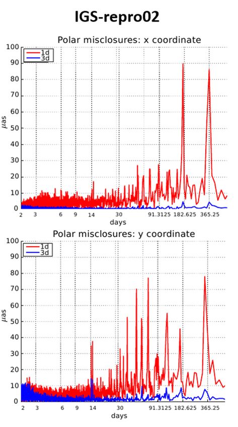
Remote Sens. 2020, 12, 2322                                                                          4 of 19

       Before combining 1-day NEQs into a 3-day solution, a consistency test is performed by fitting
the satellite positions of three subsequent 1-day orbits to a 3-day orbital arc, represented by one set of
orbit parameters over the three days. If the three subsequent orbits cannot be represented by one orbital
arc with sufficient quality, the 3-day arc is split at the day boundaries. Such arc splits are introduced if
the offset at the day boundaries is above a threshold of 4 times the arithmetic mean Root-Mean-Squared
(RMS) value, which is computed with respect to all accepted satellites of a specific GNSS. This happens
in less than 1% of all cases (e.g., when a satellite maneuver has taken place during the time period in
question). In such a case, the long-arc strategy, if not properly handled, would degrade the solution.
       Additionally, validation of the station-related parameters is performed in order to detect stations
with discontinuities between subsequent days (e.g., due to equipment changes or earthquakes), before
they can be connected to one set of coordinate parameters over three days. If such a station is detected,
it is pre-eliminated for that day, preventing its contribution to the 3-day coordinate solution.
       After these preparatory steps, three subsequent NEQs are combined into one NEQ and a 3-day
long-arc solution is invoked [22]. The middle day is then extracted to represent the 3-day orbit
referring to one particular day. The station coordinates, troposphere parameters, ERPs, and GNSS
satellite orbits are obtained based on a minimum constraints solution (with a no-net-rotation condition
applied) aligned to the IGb08 reference frame, while keeping the inner geometry of the GNSS solution.
Before the final solution is generated, the stations used for datum definition are validated by checking
the residuals of a Helmert transformation to IGb08, with a residual threshold of 10 mm for horizontal
and 30 mm for vertical components.

2.2. Generation of Gnss Clock Products
      The results from the double difference processing, described in the previous section, are then
introduced as known parameters in the generation of the GNSS clock products. Here, in the first step a
zero-difference network solution is performed, where all satellite and receiver clock parameters are
estimated with a sampling rate of 300 s. The 300 s clock solution is then the basis for the efficient
high-rate clock interpolation (EHRI) procedure using carrier-phase time-differenced measurements [8].
The changes of the receiver and satellite clock corrections from one epoch to the next are based on an
epoch difference solution and fitted to the 300 s clock solution. As a reference clock, the station with
the lowest RMS error in the linear fit and the most complete data is chosen daily.
      This procedure is limited to a sampling rate of 30 s, since the standard IGS stations provide data
only with this sampling rate, while for a further densification of the clock corrections GNSS observation
files with a higher sampling rate are needed. GNSS data with a sampling of 1 Hz are available from
the IGS real-time project [23].
      In [8], it is shown that the high-rate GPS satellite clock corrections with 5 s sampling may be
linearly interpolated, resulting in less than 2% degradation of accuracy. Figure 2 shows the number of
stations delivering high-rate Receiver Independent Exchange Format (RINEX2) [24] data for the period
between 2003 to the end of 2014. The number of stations increases from about 40 in 2003 to around
115 stations in 2014.
      Their geographical distribution is of particular importance for obtaining GNSS satellite clock
corrections that are as complete as possible. Figure 3 shows the geographical distribution of the stations
delivering high-rate RINEX data for two selected days—January 1, 2003 (black dots), and January 1,
2014 (red stars). As can be seen, besides the increasing number of GNSS stations, the geographical
coverage also significantly improves over the years. The coverage over the ocean is, however, not yet
dense enough. Consequently, the completeness of the satellite clocks over these areas heavily depends
on the availability and completeness of observations from a few stations.
Validation of the EGSIEM-REPRO GNSS Orbits and Satellite Clock Corrections - MDPI
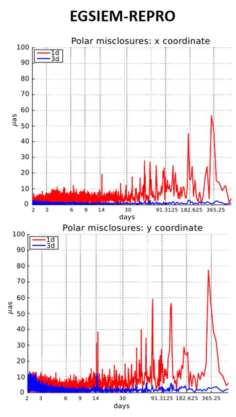
available from the IGS real-time project [24].
       In [8], it is shown that the high-rate GPS satellite clock corrections with 5 s sampling may be
 linearly interpolated, resulting in less than 2% degradation of accuracy. Figure 2 shows the number
 of stations delivering high-rate Receiver Independent Exchange Format (RINEX2) [25] data for the
 periodSens.
 Remote   between
             2020, 12,2003
                       2322 to the end of 2014. The number of stations increases from about 40 in 2003   to
                                                                                                    5 of 19
 around 115 stations in 2014.

Remote Sens. 2020, 12, x FOR PEER REVIEW                                                                     5 of 19

     Their geographical distribution is of particular importance for obtaining GNSS satellite clock
corrections that are as complete as possible. Figure 3 shows the geographical distribution of the
stations delivering high-rate RINEX data for two selected days—January 1, 2003 (black dots), and
January 1, 2014 (red stars). As can be seen, besides the increasing number of GNSS stations, the
geographical coverage also significantly improves over the years. The coverage over the ocean is,
however,   not
      Figure
       Figure 2. yet
              2.     dense
                 Number
                 Number   of enough.
                         of            Consequently,
                             stations delivering         the
                                                 high-rate    completeness
                                                           Receiver         of the
                                                                    Independent    satellite
                                                                                 Exchange     clocks(RINEX2)
                                                                                           Format     over these
areas data
      heavily   depends   on  the  availability
           for the period 2003–2015.            and   completeness   of observations
                                            data for the period 2003–2015.           from   a few  stations.

                 Geographicaldistribution
      Figure3.3.Geographical
     Figure                   distributionofofstations
                                               stationsproviding
                                                         providinghigh-rate
                                                                   high-rateRINEX2
                                                                             RINEX2data
                                                                                    dataon
                                                                                         onJanuary
                                                                                            January1,1,2003
                                                                                                        2003
      (blackdots),
     (black  dots),and
                    andon
                        onJanuary
                           January1,1,2014
                                       2014(red
                                            (redstars).
                                                 stars).

     InInthe
           theframe
               frameof of the
                           the EGSIEM-REPRO
                                EGSIEM-REPROcampaign, campaign,the  theprocedure
                                                                         proceduretotodensify
                                                                                       densifythe thesatellite
                                                                                                       satelliteclock
                                                                                                                 clock
 corrections  to 5 s sampling    for the  GLONASS     satellites was  performed  for the first
corrections to 5 s sampling for the GLONASS satellites was performed for the first time in a   time in a reprocessing
 scheme. Finally,
reprocessing          the GPS
                scheme.          satellite
                           Finally,         clock
                                      the GPS     corrections
                                                satellite  clock are providedare
                                                                  corrections  in provided
                                                                                  this reprocessing     series with a
                                                                                               in this reprocessing
 sampling
series  withrate  of 5 s from
             a sampling     rate2003
                                  of 5 onwards.
                                       s from 2003Foronwards.
                                                       GLONASS,  Forthe  determination
                                                                      GLONASS,           of complete satellite
                                                                                  the determination              clock
                                                                                                         of complete
satellite clock corrections started with data referring to year 2008 with 30 s sampling and in with 20105
 corrections   started  with   data  referring  to year   2008 with   30 s sampling  and   in with  2010  data  with
 s sampling.
data  with 5 s sampling.
 3. Results
3. Results
       The EGSIEM-REPRO and CODE contributions to the IGS-repro02 products were validated in six
     The EGSIEM-REPRO and CODE contributions to the IGS-repro02 products were validated in
 different ways. Section 3.1 analyzes polar motion misclosures with the methods originally proposed
six different ways. Section 3.1 analyzes polar motion misclosures with the methods originally
 by [25]. Section 3.2 validates the GNSS satellite clock corrections in terms of the completeness
proposed by [23]. Section 3.2 validates the GNSS satellite clock corrections in terms of the
 and Allan deviations. In Section 3.3, the results of PPP analysis using terrestrial stations are presented
completeness and Allan deviations. In Section 3.3, the results of PPP analysis using terrestrial stations
 and discussed. Section 3.4 makes use of the Satellite Laser Ranging (SLR) observation technique for
are presented and discussed. Section 3.4 makes use of the Satellite Laser Ranging (SLR) observation
 validation of the GNSS orbits by calculating the measured SLR distances to GNSS satellites using
technique for validation of the GNSS orbits by calculating the measured SLR distances to GNSS
 the reprocessed GNSS orbits and satellite corrections, as well as the corresponding ERPs and the known
satellites using the reprocessed GNSS orbits and satellite corrections, as well as the corresponding
 locations of the SLR observatories, and applies the reprocessing products to generate the orbits of
ERPs and the known locations of the SLR observatories. Section 3.5 applies the reprocessing products
 the GRACE satellites and validates the LEO orbit quality as a function of the reprocessing products.
to generate the orbits of the GRACE satellites and validates the LEO orbit quality as a function of the
reprocessing products.

3.1. ERP Misclosures
     The polar motion misclosures at the day boundaries were calculated according to Equation (1)
in [23]. One misclosure value result is used from each day for each of the polar motion coordinates x
and y.
     Figure 4 shows the polar motion misclosures, where the left column refers to the IGS-repro02
series and the right side to the EGSIEM-REPRO series. In Figure 4, the top row displays the x
Validation of the EGSIEM-REPRO GNSS Orbits and Satellite Clock Corrections - MDPI
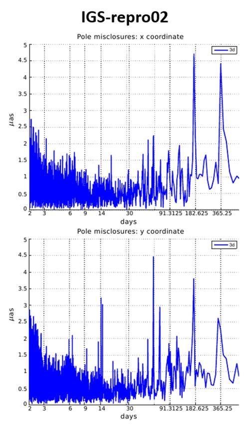
Remote Sens. 2020, 12, 2322                                                                                    6 of 19

          3.1. ERP Misclosures
               The polar motion misclosures at the day boundaries were calculated according to Equation (1)
         in [25]. One misclosure value result is used from each day for each of the polar motion coordinates x
         and y.
               Figure 4 shows the polar motion misclosures, where the left column refers to the IGS-repro02 series
         and the right side to the EGSIEM-REPRO series. In Figure 4, the top row displays the x misclosures
         and bottom row displays the y misclosures. The figure clearly demonstrates the superiority of the 3-day
         solutions
Remote Sens.        (shown
             2020, 12, x FORin blue)REVIEW
                              PEER    over the 1-day solutions (shown in red). On the other hand, it is difficult to   6 of 19
         decide which of the two series (e.g., EGSIEM-REPRO and IGS-repro02) with the same arc length is
series ofbetter.
           FigureFor4,this reason, Figure
                        providing           5 shows
                                      greater       the spectra
                                                insight,        of for
                                                         at least  the polar motionsolutions.
                                                                       the 1-day    series of Figure 4, providing
                                                                                                As opposed       to Figure 4,
         greater insight, at least for the 1-day solutions. As opposed to Figure 4, which cover the time interval
which cover the time interval 1994–2013, the spectra are based on the misclosures in the time interval
         1994–2013, the spectra are based on the misclosures in the time interval 2000–2014, thus excluding
2000–2014,    thus excluding the solutions that are still far from present-day quality.
         the solutions that are still far from present-day quality.

                                 (a)                                                                 (b)
      Figure 4.   (a) Time
               Figure         series
                       4. (a) Time    of polar
                                    series        motion
                                           of polar motion misclosures     referring
                                                            misclosures referring   to theto2nd
                                                                                             theIGS
                                                                                                 2ndreprocessing
                                                                                                     IGS reprocessing
                                                                                                                  campaigncampaign
      (IGS-repro02). (b) Time series of polar misclosures referring to the reprocessing campaignout
               (IGS-repro02).   (b) Time  series of polar misclosures referring  to the  reprocessing campaign   carried carried out
               in the frame of the EGSIEM project (EGSIEM-REPRO). The top shows misclosures in the x coordinates
      in the frame of the EGSIEM project (EGSIEM-REPRO). The top shows misclosures in the x coordinates
               and the bottom shows misclosures in the y coordinates, plotted with a shift along the vertical axis for
      and the clarity.
                bottom    shows
                       Polar  motionmisclosures     in the ytocoordinates,
                                      misclosures referring                   plotted
                                                               the 1-day solution         withwith
                                                                                    are shown   a shift
                                                                                                    red,along   the vertical
                                                                                                         while polar motion axis for
      clarity. misclosures
               Polar motion       misclosures
                             referring to the 3-dayreferring   topresented
                                                     solution are  the 1-day     solution are shown with red, while polar
                                                                             in blue.
      motion misclosures referring to the 3-day solution are presented in blue.
Validation of the EGSIEM-REPRO GNSS Orbits and Satellite Clock Corrections - MDPI
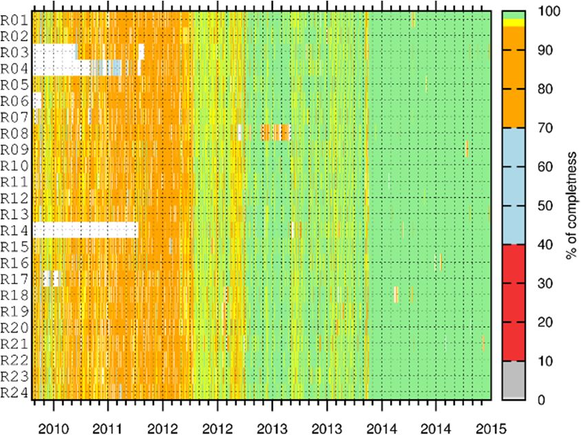
Remote Sens. 2020, 12, 2322                                                                                               7 of 19
Remote Sens. 2020, 12, x FOR PEER REVIEW                                                                                 7 of 19

                               (a)                                                          (b)

     Figure
      Figure 5. (a) Power
                     Powerspectrum
                              spectrum     of polar
                                        of polar      motion
                                                 motion        misclosures
                                                          misclosures          referring
                                                                        referring         to IGS
                                                                                  to the 2nd      2nd IGS reprocessing
                                                                                             the reprocessing    campaign
     campaign    (IGS-repro02).
      (IGS-repro02).                (b) Powerof spectrum
                       (b) Power spectrum                     of polarreferring
                                                  polar misclosures       misclosures
                                                                                  to thereferring  to the
                                                                                         reprocessing       reprocessing
                                                                                                       campaign    carried
     campaign
      out in the carried
                  frame ofoutthein   the frame
                                 EGSIEM           of the
                                             project       EGSIEM projectMisclosures
                                                      (EGSIEM-REPRO).                       in x coordinates
                                                                                (EGSIEM-REPRO).       Misclosures      in x
                                                                                                               are shown
      on the top and
     coordinates   are misclosures
                        shown on the      the yand
                                       in top    coordinates
                                                    misclosuresare in
                                                                    shown
                                                                       the yon  the bottom,
                                                                              coordinates     plotted
                                                                                            are shownwith    a shift
                                                                                                         on the       along
                                                                                                                  bottom,
      the vertical
     plotted with axis   foralong
                    a shift  clarity.
                                   thePolar  motion
                                        vertical  axismisclosures    referring
                                                       for clarity. Polar       to the
                                                                           motion      1-day solution
                                                                                    misclosures         are shown
                                                                                                  referring          in red,
                                                                                                             to the 1-day
     solution are shown in red, while polar motion misclosures referring to the 3-day solutioncases,
      while polar   motion    misclosures    referring  to the 3-day    solution  are presented   in blue.  In both     are
      the chosenintime
     presented      blue.interval
                           In bothiscases,
                                      2000–2014.
                                            the chosen time interval is 2000–2014.

       Figure 5 5reveals
     Figure          reveals
                           that that   the EGSIEM-REPRO
                                 the EGSIEM-REPRO            series isseries    is to
                                                                         superior    superior     to the IGS-repro02
                                                                                         the IGS-repro02       series—the
 series—the    amplitudes    of  the spectral   lines  of the  1-day    solutions   for  periods
amplitudes of the spectral lines of the 1-day solutions for periods > 30 days are greatly reduced  > 30   days  are greatly
                                                                                                                      in the
 reduced   in the  right  side of  Figure  5  compared      to the  left side  of  Figure   5, while
right side of Figure 5 compared to the left side of Figure 5, while the amplitudes in y with the periodthe  amplitudes      in
 y with
of       the period
   one year            of one yearwhich
              are an exception,      are anare
                                             exception,
                                                 almost the which
                                                               sameare inalmost   the same
                                                                          both daily           in both
                                                                                        misclosure       dailyIn
                                                                                                      series.   misclosure
                                                                                                                  order to
 series. In order  to  assess the  quality  of the   3-day  solution’s   power    spectrum
assess the quality of the 3-day solution’s power spectrum shown in Figure 5, this is plotted   shown    in Figure   5, this
                                                                                                                          byis
 plotted  by  skipping    1-day   solutions,   as  presented    in Figure   6.  As   can  be  seen,  the
skipping 1-day solutions, as presented in Figure 6. As can be seen, the amplitudes are greatly reduced     amplitudes     are
 greatly
from      reduced
       Figure   5 tofrom   Figure
                      Figure   6 by5 to  Figureof
                                      a factor     6 by  a factor of approximately
                                                      approximately      50 or more. 50   Theorfigures
                                                                                                 more. The alsofigures
                                                                                                                 show also
                                                                                                                         the
 show   the superiority   of the  EGSIEM-REPRO          series with   respect  to  the  IGS-repro02
superiority of the EGSIEM-REPRO series with respect to the IGS-repro02 series; for periods between     series;  for periods
 between
30  and 600 30 days,
               and 600 thedays,   the amplitudes
                            amplitudes                are substantially
                                           are substantially      smallersmaller
                                                                             for thefor    the EGSIEM-REPRO
                                                                                        EGSIEM-REPRO           series.series.
                                                                                                                        The
 The  amplitudes    in this domain    of periods    represent   a good   quality   criterion,  since
amplitudes in this domain of periods represent a good quality criterion, since the spurious effects  the   spurious   effects
 dueto
due   toradiation
         radiationpressure
                     pressuredeficiencies
                               deficienciesin inthe
                                                  theorbits
                                                       orbitsare
                                                              are expected
                                                                   expected to to be
                                                                                  be seen.
                                                                                      seen.
Validation of the EGSIEM-REPRO GNSS Orbits and Satellite Clock Corrections - MDPI
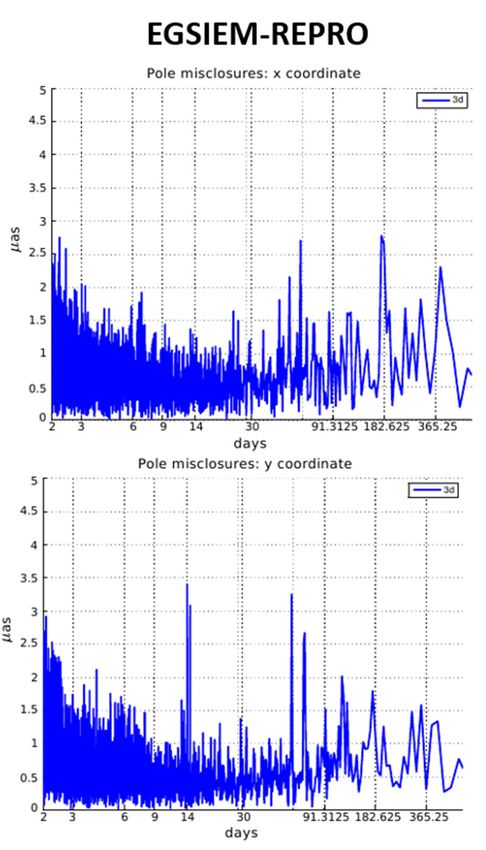
Remote Sens. 2020, 12, 2322                                                                                       8 of 19
Remote Sens. 2020, 12, x FOR PEER REVIEW                                                                         8 of 19

                              (a)                                                      (b)

     Figure
       Figure6.6.(a)
                   (a)Power
                       Powerspectrum    of polar
                              spectrum of  polarmotion
                                                 motionmisclosures
                                                         misclosuresforfor
                                                                        thethe  3-day
                                                                            3-day      solution
                                                                                   solution      referring
                                                                                            referring       to IGS-
                                                                                                      to IGS-repro02.
     repro02.  (b) Power
       (b) Power     motionmotion   of misclosures
                             of polar  polar misclosures
                                                   for thefor the 3-day
                                                            3-day        solution
                                                                   solution        referring
                                                                             referring       to EGSIEM-REPRO.
                                                                                        to EGSIEM-REPRO.        The x
     The x coordinates    are  shown on  the top and y coordinates  are shown   on  the bottom.  In both  cases,
       coordinates are shown on the top and y coordinates are shown on the bottom. In both cases, the chosen     the
     chosen  time   interval is 2000–2013.
       time interval is 2000–2013.

        Table2 2summarizes
      Table      summarizesthe  thestatistical
                                     statisticalproperties
                                                  propertiesofofthe
                                                                 thepolar
                                                                     polar motion
                                                                            motion misclosures
                                                                                     misclosures for
                                                                                                   for different
                                                                                                       differentranges
                                                                                                                  rangesof
ofperiods.
   periods.TheThenormal
                   normalRMS RMS is is
                                    provided
                                       provided  with thethe
                                                   with   label “all”,
                                                              label    whereas
                                                                    “all”,       the RMS
                                                                            whereas        referring
                                                                                      the RMS        to periods
                                                                                                referring
Validation of the EGSIEM-REPRO GNSS Orbits and Satellite Clock Corrections - MDPI
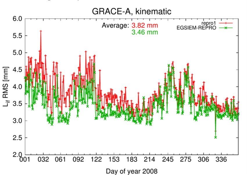
Remote Sens. 2020, 12, 2322                                                                                              9 of 19

3.2. GNSS Satellite Clock Corrections Analysis
     As the first quality control measure, the completeness of the GNSS clock corrections was checked
separately for the 300, 30, and 5 s clock corrections for both GPS and GLONASS. As an example,
Figure 7 shows the completeness of the GLONASS satellite clock correction with 30 s (Figure 7a)
and 5 s (Figure 7b) sampling rates. Note that the time scales for the figures are different due to the fact
that GLONASS satellite clock corrections with 30 s sampling are available from 2008 onwards, while
the 5 s GLONASS satellite clock corrections are available from 2010 onwards. It can be noticed that
the completeness of the 30 s clock corrections increases with time, reaching 100% at the beginning of
2010 for the majority of the satellites. The data gaps, which are visible for some satellites, are mainly
due to the reduced ground tracking network. Additionally, the full constellation for GLONASS was
not achieved until 2014; therefore, not all pseudorandom noise numbers (PRN) were constantly in use.

                              (a)                                                        (b)

   Figure 7. (a)
      Figure  7. The
                  (a)completeness    of 30 s GLONASS
                       The completeness                  (where each
                                             of 30 s GLONASS            GLONASS
                                                                    (where            satellite is shown
                                                                               each GLONASS                with
                                                                                                    satellite  is their
                                                                                                                   shown
   pseudorandom      noise numbers
      with their pseudorandom          (PRN)
                                   noise       number
                                           numbers       on the
                                                      (PRN)        y axis)
                                                               number    on satellite  clock
                                                                             the y axis)      corrections.
                                                                                           satellite          (b) The
                                                                                                     clock corrections.
   completeness   of 5 s GLONASS
      (b) The completeness      of 5 (where
                                      s GLONASSeach GLONASS
                                                       (where eachsatellite is shownsatellite
                                                                      GLONASS           with their   pseudorandom
                                                                                                 is shown     with their
   noise numbers (PRN)
      pseudorandom     noisenumber
                             numbers on(PRN)
                                         the y number
                                               axis) satellite
                                                        on theclock  corrections.
                                                                y axis)              Note
                                                                        satellite clock     that the 5Note
                                                                                         corrections.  s GLONASS
                                                                                                              that the 5 s
      GLONASS
   clock          clock
         corrections  arecorrections are only
                          only available  fromavailable
                                                the end offrom
                                                            2010the end of 2010 onwards.
                                                                  onwards.

     Since the GLONASS satellite clock corrections with 5 s sampling were calculated for the first
time in the reprocessing mode, their quality was investigated in more detail, particularly to see if
the clock determinations with 300 s, 30 s, 5 s sampling had any impact on the quality of the GLONASS
satellite clock corrections. Figure 8 shows an example of Allan deviations (ADEV) [26] of the satellite
clock corrections with different samplings for selected satellites on 27 October 2013. While both of
the GLONASS satellites, R724 (Figure 8a) and R747 (Figure 8b), are GLONAS-M types with cesium
on-board clocks, the GPS G063 satellite is a Block-IIF type and the G036 satellite is a Block IIA type,
both with rubidium on-board clocks. As can be seen from Figure 8, the lines for all three solutions are
the same, implying that the densification process works very well for interpolation.
     Another performance indicator for GNSS satellite clocks is the RMS of the daily linear fit through
the epoch-wise clock estimates. This characterizes how close a clock comes to the ideal linear drift.
The daily RMS fit of the estimated clocks for selected GPS and GLONASS satellites is shown in Figure 9.
Here, the same satellites are shown as in Figure 8.
Validation of the EGSIEM-REPRO GNSS Orbits and Satellite Clock Corrections - MDPI
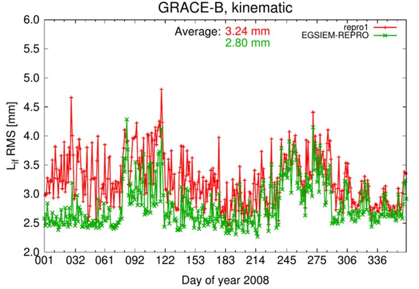
Remote Sens. 2020, 12, 2322                                                                                       10 of 19
               Remote Sens. 2020, 12, x FOR PEER REVIEW                                                                        10 of 19

                                       (a)                                                                                  (b)

    Figure 8. (a) Allan deviations for satellites with space vehicle number (SVN) R747, G063, and G0
    satellite clock corrections with different sampling corrections. (b) Allan deviations for satellites w
    space vehicle number (SVN) R724, G063, and G036 satellite clock corrections with different samplin
    Both figures refer to October 27, 2013.

    Another performance indicator for GNSS satellite clocks is the RMS of the daily linear fit t
 e epoch-wise clock estimates. This characterizes how close a clock comes to the ideal line
he daily RMS fit of the estimated(a)clocks for selected GPS and(b)GLONASS satellites is shown in
 Here, the same   satellites
              Figure 8. (a)
                 Figure     Allan
                         8. (a)    are
                                   de
                                Allan    shown
                                     viations for for
                                      deviations        as
                                                        llitesin
                                                   satesatellites Figure
                                                               with space
                                                                  with       8. number
                                                                          vehicle
                                                                       space vehicle     (SVN)
                                                                                     number    R747,
                                                                                            (SVN)    G063,
                                                                                                  R747,    andand
                                                                                                        G063,  G036
                                                                                                                  G036
                    satellite clock
                       satellite    corrections
                                 clock           with
                                        corrections   different
                                                    with         sampling
                                                          different        corrections.
                                                                    sampling             (b) (b)
                                                                              corrections.   Allan  deviations
                                                                                                 Allan         for for
                                                                                                       deviations   satellites with
                                                                                                                       satellites with
                    space  vehicle
                       space        number
                               vehicle number(SVN)  R724,
                                                (SVN)     G063,
                                                       R724,     andand
                                                              G063,   G036 satellite
                                                                         G036        clock
                                                                               satellite   corrections
                                                                                         clock         withwith
                                                                                               corrections  different  samplings.
                                                                                                                different   samplings.
                    Both  figures
                       Both        refer
                              figures    to October
                                      refer         27,27,
                                            to October  2013.
                                                           2013.

                    Another performance indicator for GNSS satellite clocks is the RMS of the daily linear fit through
               the epoch-wise clock estimates. This characterizes how close a clock comes to the ideal linear drift.
               The daily RMS fit of the estimated clocks for selected GPS and GLONASS satellites is shown in Figure
               9. Here, the same satellites are shown as in Figure 8.

                                                                            (a)

                                                                      (a)

                                                                      (b)

                    Figure 9. (a) Root-Mean-Square (RMS) of the linear(b)  fit for selected GNSS satellite clock corrections
                    shown in Figure 8a. (b) Root-Mean-Square (RMS) of the linear fit for selected GNSS satellite clock
                                  (a) Root-Mean-Square
                       Figure 9.shown                     (RMS) of the linear fit for selected GNSS satellite clock corrections
    Figure    9. (a)corrections
                      Root-Mean-Square  in Figure 8b.
                                                      (RMS) of the linear fit for selected GNSS satellite clock correctio
                       shown in Figure 8a. (b) Root-Mean-Square (RMS) of the linear fit for selected GNSS satellite clock
    shown     in Figure      8a.seen
                   As corrections
                        can be     (b)
                                    shownRoot-Mean-Square
                                       fromin Figure
                                              Figure 8b.              (RMS)
                                                      9, in terms of the  daily RMSof the     linear
                                                                                         of the linear fit   forbest
                                                                                                       fit, the  selected     GNSS satellite clo
                                                                                                                     performing
             clock is G063, which is expected since the satellite belongs to the youngest type of satellites. There is
    corrections   shown in Figure 8b.
             no noticeable difference when comparing both selected GLONASS satellites. On the other hand, it
             appears that they both perform better than the G036 satellite. Overall, there is no visible difference
   As    can between
             be seen  the different solutions with
                          from Figure         9, indifferent
                                                       terms samplings.
                                                                of the daily RMS of the linear fit,
                                                                                the best perf
ock is G063, which is expected since the satellite belongs to the youngest type of satellites. T
o noticeable difference when comparing both selected GLONASS satellites. On the other h
Remote Sens. 2020, 12, 2322                                                                                                       11 of 19

       As can be seen from Figure 9, in terms of the daily RMS of the linear fit, the best performing clock
is G063, which is expected since the satellite belongs to the youngest type of satellites. There is no
noticeable difference when comparing both selected GLONASS satellites. On the other hand, it appears
that they both perform better than the G036 satellite. Overall, there is no visible difference between
the different solutions with different samplings.
 Remote Sens. 2020, 12, x FOR PEER REVIEW                                                                                        11 of 19
       In order to further evaluate the products, particularly the GLONASS satellite clock corrections,
we performed
        In order toground-based
                        further evaluate  PPPthefor   a selected
                                                  products,          period and
                                                                particularly        thefor   selected satellite
                                                                                         GLONASS          stationsclock
                                                                                                                     for the  year 2013.
                                                                                                                          corrections,
The   reason for the
 we performed             selected period
                      ground-based      PPP isforthe  fact thatperiod
                                                   a selected    in 2013and  GLONASS
                                                                                   for selectedreached    its full
                                                                                                    stations   for constellation,
                                                                                                                   the year 2013.hence
                                                                                                                                     The
satellite   clock    corrections    were   100%     complete     for    this   year.   For   the   station
 reason for the selected period is the fact that in 2013 GLONASS reached its full constellation, hence       selection,  the  following
criteria
 satellitehad    to be
             clock       fulfilled: were
                     corrections     (1) the  station
                                            100%        had to for
                                                    complete      trackthisboth
                                                                              year.GPS Forand
                                                                                            theGLONASS          satellites;
                                                                                                  station selection,    the (2)  it had to
                                                                                                                             following
provide     RINEX2
 criteria had     to be data    with(1)
                         fulfilled:   5 sthe
                                           sampling;
                                              station had andto(3)   theboth
                                                                 track      station
                                                                                  GPShad andtoGLONASS
                                                                                                  be drivensatellites;
                                                                                                                by a hydrogen       maser
                                                                                                                           (2) it had  to
receiver
 provide clock.
             RINEX2Three  data different    solutions and
                                with 5 s sampling;         were(3)generated
                                                                     the stationbased had to  only    on the by
                                                                                                 be driven     phase   measurements,
                                                                                                                   a hydrogen     maser
namely:
 receiver clock. Three different solutions were generated based only on the phase measurements,
 namely:
1.      GPS + GLONASS kinematic solution;
                  1. GPS + GLONASS kinematic solution;
2.      GPS only kinematic solution;
                  2. GPS only kinematic solution;
3.      GLONASS only kinematic solution.
                  3. GLONASS only kinematic solution.
       The
        The right
              right side
                      side of
                            of Figure
                               Figure 1010 shows      daily RMS
                                            shows daily       RMS values
                                                                       values of  of the
                                                                                      thecoordinate
                                                                                           coordinateresiduals
                                                                                                            residualswith
                                                                                                                        withrespect
                                                                                                                              respecttoto
the
 theaa priori
         priori coordinates
                 coordinates in     the north,
                                 in the  north, east,
                                                  east,andandupupcomponents
                                                                    componentsfor       forWTZR
                                                                                             WTZRstationstation(Wettzell,
                                                                                                                 (Wettzell,Germany).
                                                                                                                              Germany).
As
 As expected, the GLONASS only solution has the worst performance, since the number of satellitesis
    expected,      the  GLONASS        only  solution     has  the   worst     performance,        since   the  number    of satellites
still lower
 is still      thanthan
           lower      GPS GPS
                            by about    25%. However,
                                   by about     25%. However, lookinglooking
                                                                           at Figure at 10a,
                                                                                         Figure one10a,
                                                                                                      can notice
                                                                                                           one can that the GLONASS
                                                                                                                      notice   that the
only   solution      performs    better   in the  north     component         than    with
 GLONASS only solution performs better in the north component than with GPS. One possible     GPS.    One    possible  explanation      for
this  is that   the  WTZR     station   is located    at  +49.08   latitude,      therefore      having
 explanation for this is that the WTZR station is located at +49.08 latitude, therefore having better      better  GLONASS        satellite
geometry      than    GPS, geometry
                            since GLONASS         hassince
                                                        a higher    inclination             ◦ ) with respect to GPS (55◦ ). In order
 GLONASS         satellite               than GPS,             GLONASS          has(64.8
                                                                                      a higher     inclination (64.8°) with respect
to confirm     this,  an  additional    PPP   solution     was  calculated       for
 to GPS (55°). In order to confirm this, an additional PPP solution was calculated    KIRU     station,   which isforlocated
                                                                                                                        KIRUinstation,
                                                                                                                                   Kiruna,
Sweden.
 which is The       results
              located        are shown
                         in Kiruna,        on theThe
                                       Sweden.       left results
                                                           side of are
                                                                    Figureshown 10, where
                                                                                     on the one left can
                                                                                                     sidesee   that GLONASS
                                                                                                            of Figure  10, whereshowsone
better
 can see repeatability
            that GLONASS   in the   northbetter
                                 shows      component        than GPS.
                                                   repeatability      in the north component than GPS.

                                 (a)                                                                (b)
       Figure10.
      Figure    10.(a)
                    (a)RMS
                        RMSinin mmmm    of the
                                     of the     kinematic
                                            kinematic       coordinates
                                                       coordinates  in theinupthe  up (top),
                                                                                (top),        north (middle),
                                                                                       north (middle),         and
                                                                                                        and east     east
                                                                                                                 (bottom)
       (bottom) components
      components      for WTZRfor     WTZR Germany)
                                  (Wettzell,    (Wettzell, Germany)
                                                            station. (b)station.
                                                                          RMS in  (b)mmRMS    in mm
                                                                                           of the     of the coordinates
                                                                                                  kinematic   kinematic
       coordinates
      in             in the
         the up (top),      up (top),
                          north        northand
                                 (middle),    (middle), and east (bottom)
                                                  east (bottom)   components components
                                                                                  for KIRU  for(Kiruna,
                                                                                                KIRU (Kiruna,
                                                                                                        Sweden)Sweden)
                                                                                                                   station.
       station. For  both  stations, the  selected period  is from December      11, 2013, to
      For both stations, the selected period is from December 11, 2013, to December 17, 2013. December   17, 2013.

      In the last step of the GNSS satellite clock corrections evaluation, the PPP solution was
 generated, for which we used GNSS satellite clock products with 30 s sampling interpolated to 5 s in
 the PPP procedure. Figure 11 shows estimated kinematic coordinates for the north component
 obtained using different sampling approaches for the first hour on December 17, 2013. On the top of
 Figure 11 the GPS+GLONASS solution is shown, the middle presents the GPS only solution, while
Remote Sens. 2020, 12, 2322                                                                                     12 of 19

          In the last step of the GNSS satellite clock corrections evaluation, the PPP solution was generated,
     for which we used GNSS satellite clock products with 30 s sampling interpolated to 5 s in the PPP
     procedure. Figure 11 shows estimated kinematic coordinates for the north component obtained using
     different sampling approaches for the first hour on December 17, 2013. On the top of Figure 11
     the GPS+GLONASS solution is shown, the middle presents the GPS only solution, while the bottom
     shows the GLONASS only solution. The corresponding Allan deviations for the full day, all three
     components, and the GLONASS only solution are presented in Figure 12.
Remote Sens. 2020, 12, x FOR PEER REVIEW                                                                                  12 of 19

                                                               (a)

                                                               (b)

                                                               (c)
     Figure  11. (a)
          Figure  11.Estimated    kinematic
                      (a) Estimated   kinematiccoordinates
                                                 coordinates in
                                                              in the  northfor
                                                                  the north  fortwo
                                                                                 twodifferent
                                                                                     different  sampling
                                                                                              sampling      types,
                                                                                                        types,      referring
                                                                                                               referring
          to the GPS+GLONASS         solution.  (b) Estimated    kinematic  coordinates  in the north
     to the GPS+GLONASS solution. (b) Estimated kinematic coordinates in the north for two different  for two  different
          sampling
     sampling        types,
                 types,     referringtotothe
                         referring        the GPS
                                              GPSsolution.
                                                    solution.(c)(c)
                                                                 Estimated  kinematic
                                                                    Estimated          coordinates
                                                                                 kinematic         in the north
                                                                                             coordinates   in thefornorth
                                                                                                                     two for
          different sampling types, referring to the GLONASS solution. All three solutions refer to the first hour
     two different sampling types, referring to the GLONASS solution. All three solutions refer to the first
          on December 17, 2013.
     hour on December 17, 2013.
Remote Sens. 2020, 12, 2322                                                                                               13 of 19
Remote Sens. 2020, 12, x FOR PEER REVIEW                                                                                13 of 19

                               (a)                                                           (b)

                               (c)

     Figure
      Figure12.12.(a)(a)Allan
                         Allandeviations
                                 deviationsofofestimated
                                                 estimatedkinematic
                                                             kinematiccoordinates
                                                                         coordinatesininthetheeast
                                                                                                eastcomponent
                                                                                                     componentfor    fortwo
                                                                                                                         two
     different  samplings     using   GLONASS      (indicated   with   GLO)   only  observations
      different samplings using GLONASS (indicated with GLO) only observations and satellite clock   and   satellite  clock
     corrections.
      corrections.(b)(b) Allan  deviations
                            Allan           of estimated
                                    deviations             kinematic
                                                of estimated           coordinates
                                                                kinematic            in theinnorth
                                                                            coordinates             component
                                                                                              the north            for two
                                                                                                           component      for
     different
      two different samplings using GLONASS only observations and satellite clock corrections. (c)Allan
                samplings     using   GLONASS       only  observations    and  satellite  clock  corrections.   (c)    Allan
     deviations
      deviationsofofestimated
                        estimatedkinematic
                                    kinematiccoordinates
                                               coordinatesininthe
                                                                theupup
                                                                      component
                                                                        component  for two
                                                                                     for two different
                                                                                               differentsamplings
                                                                                                          samplingsusing
                                                                                                                       using
     GLONASS      only   observations    and satellite clock  corrections. In all three  figures,  the Allan
      GLONASS only observations and satellite clock corrections. In all three figures, the Allan deviations    deviations
     were
      werecalculated
            calculatedover overthe
                                 theentire
                                     entireday.
                                            day.

     Looking
       LookingatatFigure
                   Figure 11,
                          11, it can
                                 can be
                                     benoticed
                                         noticedthatthatallallsolutions
                                                                solutions obtained
                                                                        obtained      with
                                                                                   with       5 s satellite
                                                                                          5 s satellite      corrections
                                                                                                        corrections  show
show  less noise
 less noise       than
            than the   the solution
                     solution  with 30with  30 s satellite
                                        s satellite correctionscorrections  that
                                                                    that were     were
                                                                               then      then interpolated
                                                                                     interpolated    to 5 s. In to 5 s. In
                                                                                                                particular,
particular,
 this can bethis can be confirmed
              confirmed  by lookingby atlooking
                                         the Allanat deviation
                                                      the Allan results
                                                                    deviation
                                                                           for results  for the estimated
                                                                                the estimated                 kinematic
                                                                                                 kinematic coordinates
coordinates   shown12.
 shown in Figure     in Here,
                        Figurethe12.Allan
                                     Here,deviation
                                            the Allan wasdeviation    was calculated
                                                                calculated                over day
                                                                            over the entire     the entire
                                                                                                      for theday  for the
                                                                                                              GLONASS
GLONASS      only solutions.
 only solutions.

  3.3.Validation
3.3.   ValidationofofGNSS
                      GNSSOrbits
                           OrbitsbybySatellite
                                      SatelliteLaser
                                                LaserRanging
                                                      Ranging
        SatelliteLaser
      Satellite   LaserRanging
                           Ranging(SLR)
                                      (SLR)totospacecraft
                                                 spacecraftequipped
                                                               equippedwithwithlaser
                                                                                  laserretroreflectors
                                                                                         retroreflectorsalways
                                                                                                           alwaysyields
                                                                                                                    yields
  highly  precise   and   unambiguous       distance   measurements      between     laser stations
highly precise and unambiguous distance measurements between laser stations and the spacecraft.      and   the spacecraft.
 AllGLONASS
All    GLONASSsatellites
                     satellitescarry
                                 carryretroreflectors,
                                        retroreflectors,and andthus
                                                                 thuscan
                                                                       canbebetracked
                                                                                trackedbybySLR.
                                                                                              SLR.TwoTwoGPSGPSsatellites
                                                                                                                 satellites
  equippedwith
equipped      withretroreflectors
                     retroreflectorswereweredecommissioned,
                                              decommissioned,namely  namelyG036,
                                                                               G036,which
                                                                                       whichlaunched
                                                                                               launchedononMarchMarch10,10,
 1994,   and   was  decommissioned        in  2014;   and   G035,  which   launched     on
1994, and was decommissioned in 2014; and G035, which launched on August 30, 1993, and was  August    30, 1993,  and   was
  decommissionedinin2009
decommissioned             2009[27].
                                 [27].Since
                                        Sincethe
                                               thereprocessed
                                                    reprocessedGLONASS
                                                                   GLONASSand    andGPSGPSorbits
                                                                                             orbitsare
                                                                                                    arebased
                                                                                                         basedsolely
                                                                                                                 solelyon
                                                                                                                        on
  microwaveobservations,
microwave        observations,SLR SLRisisa afully
                                             fullyindependent
                                                     independenttechnique
                                                                     techniquethatthatcan
                                                                                        canbebeused
                                                                                                 usedtotovalidate
                                                                                                           validatethese
                                                                                                                     these
  orbitsbybycalculating
orbits        calculatingthe themeasured
                                  measuredSLR  SLRdistances
                                                      distancestotoGNSS
                                                                    GNSSsatellites
                                                                            satellitesusing
                                                                                         usingthe
                                                                                                thereprocessed
                                                                                                     reprocessedGNSSGNSS
  orbitsand
orbits   andsatellite
               satelliteclock
                          clockcorrections,
                                corrections,asaswell
                                                   wellasasthe
                                                            thecorresponding
                                                                 correspondingERP’sERP’sandandthe
                                                                                                theknown
                                                                                                     knownlocations
                                                                                                              locationsofof
  the SLR   observatories.
the SLR observatories.
        TheSLR
      The    SLR   observations
                 observations       (“observed“)
                                 (“observed“)     areare  directly
                                                       directly     compared
                                                                compared         to geometric
                                                                            to the   the geometric     distance
                                                                                                 distance         between
                                                                                                            between   the
  the stations
SLR    SLR stations   andmicrowave-based
                and the      the microwave-based        orbit (“computed“)
                                                 orbit (“computed“)      withoutwithout    estimating
                                                                                    estimating          any parameters.
                                                                                                 any parameters.     The
 Theresiduals
SLR    SLR residuals     (“observed
                 (“observed     minusminus      computed“),
                                        computed“),             therefore,
                                                        therefore,  containcontain
                                                                             potentialpotential   range reflector
                                                                                         range biases,   biases, reflector
                                                                                                                   offset
  offset uncertainties,
uncertainties,   and other andpotential
                                other potential
                                         systematicsystematic   effects [15,27].
                                                        effects [15,27].
     To demonstrate possible systematic effects in the GNSS orbits, we typically present the SLR
residuals as a function of the solar beta angle (i.e., the elevation of the Sun above the orbital plane),
Remote Sens. 2020, 12, 2322                                                                                             14 of 19

      To demonstrate possible systematic effects in the GNSS orbits, we typically present the SLR
 Remote Sens.as
residuals      2020, 12, x FOR of
                  a function    PEER
                                  theREVIEW                                                                     14 of 19
                                       solar beta angle (i.e., the elevation of the Sun above the orbital plane),
as a function of the elongation angle of the Sun (i.e., the angle between the Sun and the satellite, as seen
 as a function
from   the geocenterof the[28]),
                            elongation    angle of the Sun
                                 or as a combination        (i.e., the angle between the Sun and the satellite, as
                                                        of both.
 seenFigure
       from the      geocenter
                 13 shows    the [28]), or as a combination
                                  SLR residuals   of GLONASS-M of both.
                                                                      orbits between January 2003 and December
       Figure     13 shows    the  SLR  residuals  of GLONASS-M
2013. The systematic pattern, which can be seen for the                orbits  between
                                                                          orbits         January 2003
                                                                                   of IGS-repro02       and December
                                                                                                     (Figure  13, top),
 2013.   The    systematic     pattern,  which   can  be seen  for  the  orbits  of  IGS-repro02
is significantly reduced when using the EGSIEM-REPRO orbits (Figure 13, bottom). This improvement  (Figure  13, top), is
issignificantly
    mainly related reduced
                        to thewhen
                                 use using
                                     of the the EGSIEM-REPRO
                                             extended   ECOM instead orbitsof(Figure  13, bottom).
                                                                               the original  ECOM.  This
                                                                                                      Theimprovement
                                                                                                           reasons for
 is mainly    related   to  the use  of the extended   ECOM    instead   of the  original ECOM.
the larger scatter of the SLR residuals when using the extended ECOM (in particular for large      The  reasons  for the
                                                                                                            elongation
 larger  scatter    of the  SLR  residuals
angles) are discussed in Section 4.         when   using  the extended    ECOM     (in particular for large elongation
 angles) are discussed in Section 4.

                                                               (a)

                                                               (b)
       Figure13.
      Figure   13. (a)
                    (a) SLR
                         SLR residuals
                               residuals to
                                          toGLONASS-M
                                             GLONASS-M orbits orbits from
                                                                      fromIGS-repro02
                                                                            IGS-repro02using
                                                                                          usingthetheoriginal
                                                                                                       originalEmpirical
                                                                                                                 Empirical
       CODEOrbit
      CODE     OrbitModel
                       Model(ECOM).
                                (ECOM).(b) (b)SLR
                                               SLRresiduals
                                                    residualstotoGLONASS-M
                                                                    GLONASS-Morbitsorbitsfrom
                                                                                          fromEGSIEM-REPRO
                                                                                                 EGSIEM-REPROusing    using
       theextended
      the  extendedECOM.
                       ECOM.For  Forboth
                                     bothfigures,
                                           figures,residuals
                                                    residualsbetween
                                                               betweenJanuary
                                                                         January2003
                                                                                  2003and
                                                                                        and December
                                                                                             December 20132013 are
                                                                                                               are shown.
                                                                                                                    shown.
       Observations for
      Observations      for four
                             four GLONASS
                                    GLONASS satellites
                                                satellites (space
                                                            (space vehicle
                                                                     vehicle number
                                                                             number (SVN)
                                                                                      (SVN) 723,
                                                                                               723, 725,
                                                                                                     725, 736,
                                                                                                           736, 737)
                                                                                                                 737) were
                                                                                                                      were
      excluded
       excludeddue duetotoanomalous
                           anomalouspatterns.
                                        patterns.Residuals
                                                   Residualsof  ofthese
                                                                   theseGLONASS
                                                                         GLONASSsatellites
                                                                                     satellitesincreased
                                                                                                increasedafter
                                                                                                            afteraacertain
                                                                                                                    certain
      time
       timeafter
             afterlaunch
                    launch[29].  Furthermore,
                              [29]. Furthermore,residuals  withwith
                                                    residuals    absolute  beta angles
                                                                       absolute        smaller
                                                                                beta angles      than 15◦
                                                                                              smaller      are 15◦
                                                                                                        than   not are
                                                                                                                    shown
                                                                                                                        not
      due  to unmodeled
       shown                 attitude behavior
                due to unmodeled        attitudeduring
                                                  behavioreclipses.
                                                               during The black line
                                                                        eclipses. Theindicates  the indicates
                                                                                       black line    linear regression   of
                                                                                                                 the linear
      the SLR residuals
       regression           as a function
                    of the SLR   residualsofasthe elongation
                                               a function       angle.
                                                            of the  elongation angle.

3.4.
 3.4. Quality
      Quality Assessment
                AssessmentUsing
                              UsingGRACE
                                     GRACEPrecise
                                              PreciseOrbit
                                                      OrbitDetermination
                                                               Determination
      As
       As aa final
              finalquality
                    quality control,
                              control, GRACE
                                        GRACE PODPOD based
                                                         based on on undifferenced
                                                                      undifferenced GPS
                                                                                      GPS data
                                                                                            data was
                                                                                                  wasperformed
                                                                                                       performed to to
efficiently  validate   the global  GPS  orbit and  clock    solutions over  all regions of the Earth by
 efficiently validate the global GPS orbit and clock solutions over all regions of the Earth by processingprocessing
the
 thedata
      datafrom
            fromaasingle
                     singlereceiver
                             receiveronly.
                                      only.
      Figure   14 shows
       Figure 14 shows thethe  daily RMSRMS
                                   daily   values of the of
                                                values     ionosphere-free   carrier-phase
                                                               the ionosphere-free          residuals residuals
                                                                                      carrier-phase   of a kinematic
                                                                                                                  of a
orbit  determination     for GRACE-A     (shown   on  left  side of Figure 14)  and  GRACE-B
 kinematic orbit determination for GRACE-A (shown on left side of Figure 14) and GRACE-B (shown (shown   on the right
side  of Figure
 on the           14) over
          right side        the year
                       of Figure  14)2008.
                                       over The
                                            the values   in red
                                                year 2008.        were
                                                                The    calculated
                                                                    values  in red using
                                                                                    were the  GPS orbits
                                                                                          calculated      andthe
                                                                                                      using    clocks
                                                                                                                  GPS
orbits and clocks from CODE’s contribution to the first IGS reprocessing campaign
(http://acc.igs.org/reprocess.html, henceforth repro1), while the values in green present the results
obtained with EGSIEM-REPRO products. The reason why repro1 products were used for validation
at this stage is that there is no consistent set of GPS orbits and clocks available from the CODE
Remote Sens. 2020, 12, 2322                                                                                         15 of 19

       Remote Sens. 2020, 12, x FOR PEER REVIEW                                                                15 of 19

from CODE’s      contribution
      contribution                 to the first
                      to the IGS-repro02.        IGS
                                              More    reprocessing
                                                    importantly,       campaign
                                                                   it was  stated by(http://acc.igs.org/reprocess.html,
                                                                                      [13] that the combined satellite
henceforth
      clock corrections from different AC’s are severely limited byresults
              repro1),    while   the   values   in  green  present    the            obtained
                                                                              large residual      with
                                                                                              biases andEGSIEM-REPRO
                                                                                                         incompatible
products.   The
      satellite   reasonmodels
                attitude   why repro1
                                    adoptedproducts      were
                                              by different    used for validation at this stage is that there is no
                                                           AC’s.
consistentInsetboth
                 of GPS
                      cases,orbits
                             the same andantenna
                                            clocks phase
                                                    available
                                                          centerfrom   the CODE
                                                                  variations          contribution
                                                                                were applied,   whichto  the estimated
                                                                                                       were   IGS-repro02.
      using EGSIEM-REPRO
More importantly,                  products.
                       it was stated    by [13]For  most
                                                 that the days,  a clearsatellite
                                                          combined        reduction   of corrections
                                                                                  clock  the phase RMSfromcan  be seen,AC’s
                                                                                                            different
      indicating   a better  fit of  the GPS   observations  when     using  the  new  products.
are severely limited by large residual biases and incompatible satellite attitude models adopted  In terms  of average by
      values  calculated
different AC’s.            over  the   entire year, the improvement     for the  GRACE-A     and  GRACE-B    kinematic
       orbits is 0.36 and 0.44 mm, respectively.

                                                             (a)

                                                             (b)

      FigureFigure   14.RMS
               14. (a)   (a) RMS  of ionosphere-free
                              of ionosphere-free     carrier-phaseresiduals
                                                   carrier-phase   residuals of
                                                                             ofkinematic
                                                                                kinematicprecise orbit
                                                                                           precise     determination
                                                                                                   orbit  determination
             (POD) for GRACE-A. (b) RMS of ionosphere-free carrier-phase residuals of kinematic precise orbit
      (POD) for GRACE-A. (b) RMS of ionosphere-free carrier-phase residuals of kinematic precise orbit
             determination (POD) for GRACE-B. The numbers indicate the average RMS values over the entire
      determination (POD) for GRACE-B. The numbers indicate the average RMS values over the entire year.
             year. In both figures values in red were calculated using the GPS orbits and clocks from CODE’s
      In both figures values in red were calculated using the GPS orbits and clocks from CODE’s contribution
             contribution to the first IGS reprocessing campaign (repro1), while the values in green present the
      to the results
              first IGS  reprocessing campaign (repro1), while the values in green present the results obtained
                      obtained with EGSIEM-REPRO products.
      with EGSIEM-REPRO products.
             Since the two GRACE satellites are equipped with SLR reflectors, we can make use of this
     In  both cases,
      technique  as anthe    same antenna
                         independent          phase center
                                       orbit validation.      variations
                                                         For this analysis,were
                                                                            normalapplied,   which
                                                                                     points from  16 were  estimated
                                                                                                     SLR stations
using (using
       EGSIEM-REPRO
              coordinates fromproducts.    For which
                                   SLRF2008,   most days,    a clear reduction
                                                      were extrapolated            of the
                                                                           to epoch)  werephase
                                                                                            used. RMS
                                                                                                   Laser can  be seen,
                                                                                                         reflector
indicating
      arraya(LRA)
              betterrange
                     fit of corrections
                            the GPS observations
                                        were appliedwhen    usingtothe
                                                      according        new
                                                                     [30].   products.
                                                                           Tables 3 and 4Insummarize
                                                                                            terms of average    values
                                                                                                       the results
      of the SLR validation   in terms of the mean and  standard  deviation  values  in mm  for
calculated over the entire year, the improvement for the GRACE-A and GRACE-B kinematic orbits isreduced-dynamic
      and0.44
0.36 and   kinematic  orbits, respectively.
               mm, respectively.
     Since the two GRACE satellites are equipped with SLR reflectors, we can make use of this technique
as an independent orbit validation. For this analysis, normal points from 16 SLR stations (using
coordinates from SLRF2008, which were extrapolated to epoch) were used. Laser reflector array
(LRA) range corrections were applied according to [30]. Tables 3 and 4 summarize the results of
You can also read