Volcanic Ash Identification at Saltese Flats, Eastern Spokane County, Washington
←
→
Page content transcription
If your browser does not render page correctly, please read the page content below
Volcanic Ash Identification at Saltese Flats,
  Eastern Spokane County, Washington
                          Andrew Buddington
                             Alan Belasco
                            Katlin Gamache
                             Jalyn Osgood

      Science Department, Spokane Community College, Spokane,
                            Washington

   Corresponding author E-mail address: andy.buddington@scc.spokane.edu

                                             Image courtesy of Spokane County

June 2021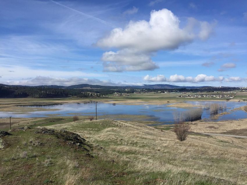
PROJECT OVERVIEW

Saltese Flats, in eastern Spokane County, is a wetland marsh area underlain by extensive peat
deposits. In 1958, a study evaluating peat resources in Washington State reported a significant
buried tephra horizon from a series of soil bore holes (Rigg, 1958). The tephra was not
described in detail, and a volcanic source was not correlated. In 2019, the Spokane County
wetlands restoration project at the site afforded direct examination of the tephra (ash), via
excavation. This study presents the results of trench mapping, sampling, and tephra
characterization from the Saltese site along with the volcanic source identification and
correlation using glass shard geochemistry.

INTRODUCTION

The Cascade Range consists of nearly twenty active or recently dormant volcanoes along the
western portions of California, Oregon, Washington, and British Columbia. The modern Cascade
volcanoes, known as the “High Cascades”, are dominated by composite volcanoes and have
been erupting for at least the last 1 million years. In the last 4,000 years alone, the United
States Geological Survey (USGS) has identified multiple major eruptions from 13 separate
Cascade volcanoes (Myers and Driedger, 2008). Volcanic ash from Alaskan volcanoes and the
Yellowstone caldera have also been identified. Needless to say, significant amounts of volcanic
ash from multiple sources and different dates have been deposited over the western United
States and Canada.

Volcanic ash layers can be seen around Spokane County, such as along Interstate 90 at Sunset
Hill and just north of Qualchan Golf Course adjacent to Highway 195. Longtime residents of the
Inland Northwest remember well the ash deposited from the May 18th, 1980 Mt. St. Helens
eruption. Yet another layer of volcanic ash, which is the subject of this paper, was recently
exposed during construction of the Spokane County Saltese Wetlands Restoration Project.

Prior to 1890, Saltese Flats was a swampy shallow lake to peat bog wetland (Saltese Lake). In
the 1890’s Valley pioneer Peter Morrison homesteaded the area and began draining the lake as
part of a larger plan to create agricultural land for growing Timothy Hay used for horse and
cattle feed (Lambeth, 2021, Edelin, 2018). Spokane County acquired the land from the Morrison
family for purposes of restoring the area to wetlands, and for educational opportunities and
recreation. The restoration project began in 2019 with an estimated completion date in 2021
and completion of the Doris Morrison Learning Center in early 2022.

During the wetland restoration process, excavation exposed a layer of light-gray powdery
material approximately 6 feet (190 centimeters) below the surface. The layer, about 2 feet thick
(71 centimeters) was recognized by local resident and retired geologist Jerry Booth as a
potentially significant volcanic ash horizon. Further field and preliminary lab examination by
Spokane Community College (SCC) Geology instructor, Andy Buddington, confirmed the
material as a relatively clean volcanic ash. This report presents the findings of the resulting
undergraduate research project performed by SCC students Alan Belasco, Jalyn Osgood, and
Katlin Gamache.
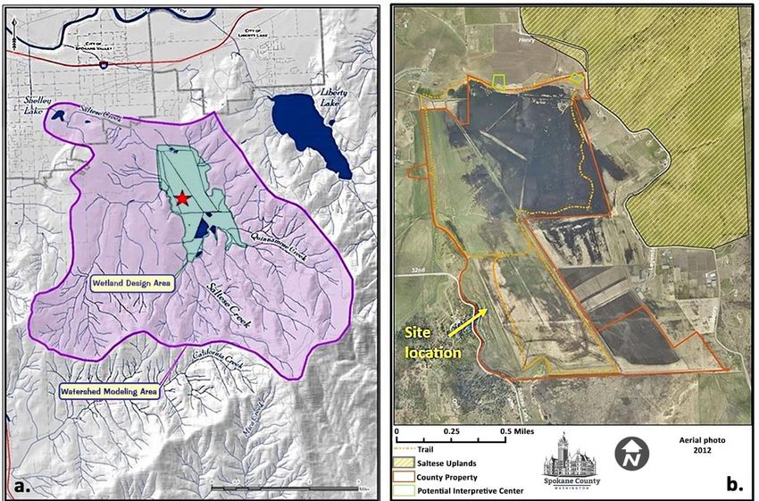
SITE LOCATION AND LOCAL GEOLOGY

Saltese Flats occur within a small, NNW-trending basin (2.5 miles by 1 mile) located between
bedrock ridges at the northern base of Mica Peak, approximately 2 miles west of the Liberty
Lake basin along the southern edge of the Spokane Valley (see Figure 1a). Adjacent to the Flats
on the east is the Saltese Uplands Conservation Area, which is underlain by metamorphic
bedrock, the Hauser Lake Gneiss, and consists of gneiss, schist, and amphibolite (Buddington, et
al., 2015). The prominent N-S trending ridge directly west of Saltese Flats is composed of rusty-
colored Hauser Lake Gneiss. Farther west are scattered exposures of Columbia River basalt and
Missoula Flood sediments (Weis, 1968). The Saltese Flats are part of the Saltese Creek
watershed in which surface streams and groundwater flows northward into the Spokane Valley-
Rathdrum Prairie Aquifer system (Figure 1a). Saltese Creek drains the northern slopes of Mica
Peak, which is underlain by metamorphic gneiss and schist. The study site is located along the
southwestern margin of the Saltese Flats wetland area, which is now administered by Spokane
County (Figure 1b).

Figure 1. Location maps of Saltese Flats and site study area. (a) Saltese Flats, pre-restoration (green outline)
within the Saltese Creek watershed (purple outline), with the study site indicated by the red star (image
courtesy of SCC Environmental Sciences Department); (b) Saltese wetlands restoration area and study site
location (image courtesy of Spokane County Environmental Services).

SALTESE FLATS PEAT, PALEOLAKE SALTESE AND WETLAND RESTORATION

In 1958, a Washington Division of Mines and Geology study done by Dr. George Rigg examined
the peat resources of Washington State. Peat is a carbon-rich, sedimentary deposit composed
of partially decayed plant matter with variable amounts of water, and forms in bogs, wetlands,
and shallow lakes. Peat is generally heterogeneous and comprised of fibrous materials including
leaves, stalks, grasses, moss, roots, and other organic matter. As part of his extensive study,
Rigg investigated peat deposits at Saltese Flats, Liberty Lake, and Newman Lake, along with
other peat occurrences throughout Spokane County. Rigg mapped the surface area of each peat
occurrence along with borehole mapping and sampling. The borehole work allowed for
subsurface determination of peat thicknesses and depths, as well as developing the
stratigraphy of the subsurface peat, soils, and sediments such as lacustrine (lake) and fluvial
(stream) deposits. Rigg diligently recorded the presence and thicknesses of what he termed
pumicite (volcanic ash) along with diatomite and woody material.

The report identifies, via a west-to-east subsurface borehole transect, a continuous light-gray
pumicite horizon under Saltese Flats ranging up to several feet in thickness, with depths to the
top of the pumicite layer at just under 5 feet on the western side to approximately 13.5 feet (to
the top of the pumicite) in the central and eastern portions of the basin (Figure 2). The pumicite
thickens from approximately 1 foot (30 cm) on the west to just over 2 feet (65 cm) in the
central portions. Although borehole #7 doesn’t completely penetrate the pumicite, it appears
that the top of the horizon is beginning to shallow toward the eastern side of the basin as
would be expected. The profile shows sedimentary peat directly underlying the pumicite, and in
hole #4, lake mud and sand underlies the sedimentary peat then diatomite to a depth just
under 20 feet. It should be noted that borehole #8, located approximately 3700 feet north of
the transect line, shows the top of the pumicite unit at approximately 9 feet depth, indicating a
shallowing of the basin to the north.

Figure 2. Saltese Flats subsurface profile from boreholes and surface map of area and the borehole profile
line, taken from Rigg, 1958.

Our study site in this report is approximately 500 feet south of Rigg’s profile line. Based on the
transect profile, the pumicite unit is continuous and significant in thickness, portraying the
paleotopography of the prehistoric lake (Saltese Lake) bottom. Pumicite, as used by Rigg, is a
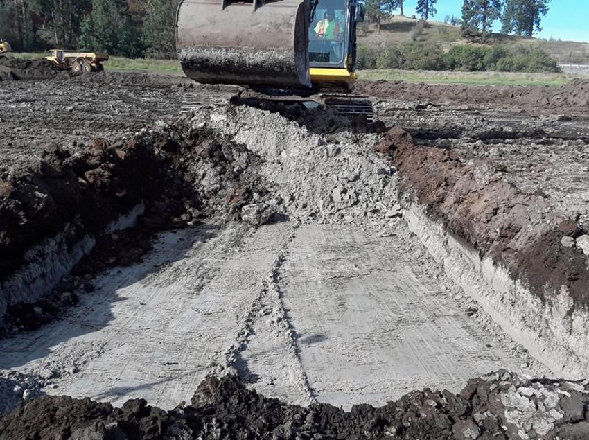
term no longer in use, but in this case represents volcanic ash. Regardless of terminology, the
continuous nature and thickness of the pumicite suggests the potential of a significant volcanic
airfall deposit blanketing the entire lake bottom. An alternative origin for the horizon could
have been deposition via reworking of surface ash either from runoff by local streams into the
basin, or redeposition of ash into the basin by wind. The 1958 study did not describe the ash
horizon beyond its color, depth, and thickness.

It should be noted that Rigg reported significant gray to white pumicite at the two Newman
Lake peat occurrences he studied, but interestingly, no discernable pumicite layer at Liberty
Lake. Rigg suggested there may be pumicite within the Liberty Lake peat but “scattered in other
materials”.

In 2019, Spokane County Environmental Services began a wetland restoration project at Saltese
Flats. Parts of the area underwent shallow excavation for the development of a surface feature,
“Pete’s Pond” named after the late Pete Morrison. During the excavation a significant horizon
of light-gray colored, fine volcanic ash was exposed in the southwestern portion of the area
(Figure 3).

Figure 3. Saltese Flats light-gray ash horizon with initial exposure during excavation of wetland pond.

TRENCH STRATIGRAPHY

With permission from Spokane County Environmental Services, a temporary trench was
excavated for the purpose of subsurface mapping and sampling of the ash layer (Figure 4). The
trench was excavated during the wetland restoration process but, due to safety concerns, was
not entered. General descriptions, thickness measurements, and sampling were performed at
the surface.

The trench stratigraphy is shown in Figure 5. From the top of the trench down to 190 cm is dark
brown to blackish peat. The ash, encountered at 190 cm depth, exhibits a light-gray color, and

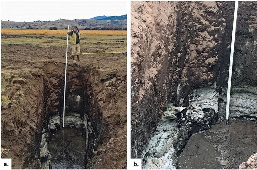
occurs to a depth of 260 cm (103 in) with a thickness of approximately 71 centimeters (28 in).
Directly below the ash is a thin (14 cm) layer of bluish-colored, fine sand, with dark brown peat
to the trench bottom (365 cm).

The upper and lower contacts of the ash are sharp, displaying no signs of mixing, interbedding
or gradation with the underlying blue sand or overlying peat. The ash layer is very uniform, and
no obvious stratification was observed.

Figure 4. Field photos of study site. (a) trench with ash exposure, (b), close-up of ash layer near base of
trench. Note that the trench is in-filling with groundwater.
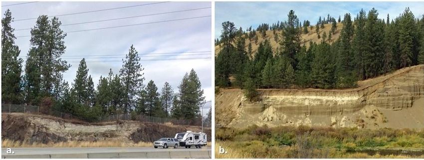
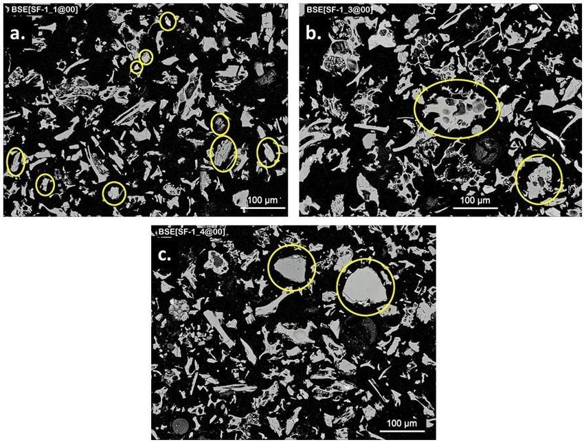
Figure 5. Stratigraphic column of the Saltese Flats site trench of this study. Ash samples are indicated by SF-
2U and SF-2L.

ASH CHARACTERISTICS AND COMPOSITION

Three ash samples were collected for examination and analysis. SF-1 is a grab sample from the
trench pile. Sample SF-2U is from the upper 20 cm of the ash layer taken in situ, and SF-2L is
from the lower 20 cm of the ash layer. Samples were dried, then examined via grain mount
petrography and Scanning Electron Microscope (SEM) imagery.

Ash Components and Mineralogy

The ash is composed of fine (
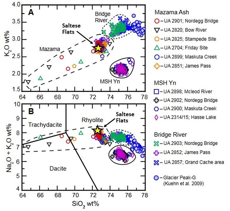
Figure 6. SEM images of Saltese Flats ash. (a) SF-1_1, showing vesicular glass shards with mineral and rock
fragments (circled), (b) SF-1_3, volcanic rock fragment containing ultra-fine microlites (lower right, circled)
and large vesicular glass fragment (center, circled), (c) SF-1_4, showing two large mineral fragments (circled).

Blue Sand

Directly below the ash is a thin layer (~14 cm) of fine, bluish-colored sand. The contact between
the sand and the overlying ash is sharp. The sand is well-sorted and consists of subangular (to
rare subrounded) grains ranging from 0.250 to 0.125 mm in size. The mineral composition of
the sand consists of quartz, feldspar, muscovite, biotite, with accessory amounts of epidote,
chlorite (after mica) and zircon. There are also grains of polygranular quartz and several
unidentified components, including opaques.

Upon excavation of the trench, the sand exhibited a defined light-blue coloration, but after one
to two weeks in the lab after drying, the sand turned gray to brownish-gray in color.

Ash Chemistry

The three Saltese samples were sent to the Peter Hooper Geoanalytical Laboratory at
Washington State University for microprobe glass shard analysis (n=25 shards per sample) for
major element compositions using a JEOL JXA8500F field emission electron microprobe. The
elemental analyses were then averaged with standard deviations calculated (Table 1). SiO2
compositions range from 72.78-72.97%, with Na2O and K2O compositions ranging from 5.39-
5.53%, and 2.74-2.79%, respectively.

In general, the glass shard major element oxide analyses were very consistent indicating no
significant weathering or chemical variation within the Saltese ash layer.

       Table 1. Summary of averaged major element oxide, glass shard analyses of the Saltese ash.

VOLCANIC SOURCE CORRELATION

The 1958 study by Rigg conclusively indicated the presence of a significant tephra layer
underlying Saltese Flats. But a volcanic source or event date was not directly addressed for the
Saltese ash. Rigg suggested, generally, that pumicite (ash) deposits within the many peat areas
of Washington State, and specifically eastern Washington, likely originated from Glacier Peak
approximately 6700 years ago. He based his correlations on a 1957 study (Rigg and Gould) that
compared grain size and mineral content of ash deposits from peat areas across the state to a
prominent tephra horizon at two sites in western Washington. At the western Washington
sites, peat directly beneath the tephra was dated by radiocarbon (C14) at 6700 years. In a later
study, Powers and Wilcox (1964) reexamined the tephra samples of Rigg and Gould, and
correlated them to tephra samples of Mount Mazama at Crater Lake. More recent studies
(Egan, et al., 2015) confirm the Powers and Wilcox conclusions and show that the Rigg and
Gould C14 date when calibrated to a cybp (calendar years before present) age, correlates with
the 7700 cybp “climactic” eruption of Mount Mazama.

Volcanic ash, due to its fine-grained nature, can travel great distances upon eruption into the
atmosphere. Because individual volcanic events typically have specific geochemical
compositions unique to the event (and volcano) of origin, specific far-distanced eruptive events
can be correlated by glass shard major element geochemistry. Volcanic glass shards are erupted
microscopic glass particles and represent the magmatic composition of the specific source
event from which they originated. Although composite volcanoes such as those of the Cascade
Range can have variations in magmatic chemical compositions over time, typically individual
eruptive events are chemically uniform. Therefore, glass shard analysis can be very helpful in correlating an unidentified ash layer to its source. The major element oxide data obtained from glass shard microprobe analyses (25 shards per sample) were compared to the WSU Pacific Northwest tephra database (1726 records) for correlation analysis to ash chemistries of known events. Based on this statistical comparison, the Saltese Flats ash matches the Mount Mazama “climactic” eruption at 7700 cybp (calendar years before present). The correlation is based on matches to twenty-two known Mazama (7700 cybp) samples with a similarity coefficient of 0.98 (Table 1). The correlation analysis and similarity coefficient determination is that of Borchardt et al., 1972. The Saltese data were then compared to other known Holocene tephra occurrences in southern Canada including Mount Mazama, Mount St. Helens, Bridge River (Mount Meagher), and Glacier Peak (Figure 7), as well as dated rock samples in the Crater Lake area of southwestern Oregon (Figure 8). In all cases, the Saltese Flats ash correlates very closely to the Mazama 7700 cybp climactic eruption. Figure 7. Major element vs. SiO2 plots for event correlation (modified from Jensen et al., 2019). (a) plot of wt.% K2O vs. SiO2 with averaged Saltese values for comparison (yellow star), (b) wt.% K2O + Na2O vs. SiO2. Mazama data are from the 7700 cybp climactic eruption. Note the Glacier Peak-G samples are from the 13,710 – 13,410 cybp eruptions.
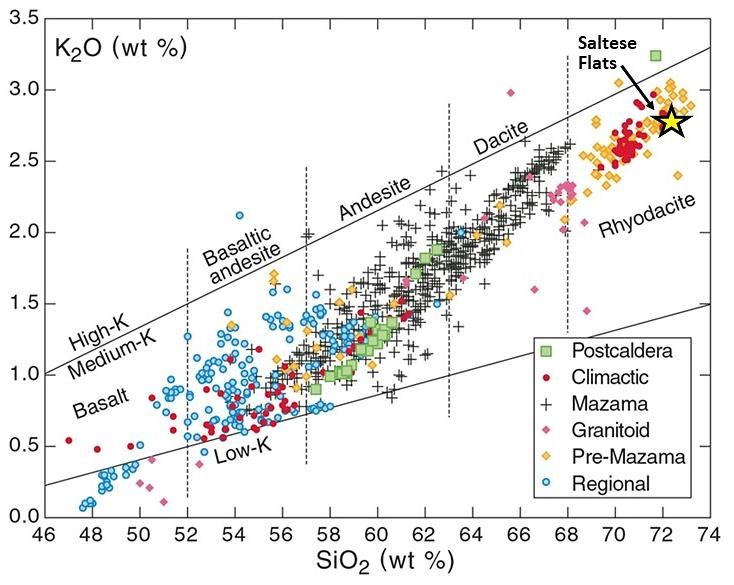
Figure 8. Plot of K2O vs. SiO2 (wt.%) of volcanic rocks from the Crater Lake area; modified after Bacon and
Lanphere, 2006. The averaged Saltese Flats data shown as yellow star.

MOUNT MAZAMA CLIMACTIC ERUPTION

Mount Mazama is a major Cascade volcano but has not been significantly active since the
climactic eruption (7700 cybp) and has not erupted in the last 4000 years (Myers and Driedger,
2008). Mount Mazama was thought to rival, in size and height, todays large Cascade composite
volcanoes such as Rainier and Shasta (Bacon and Lanphere, 2006, USGS, 2021). The 7700 cybp
eruption was the largest Cascade eruption in the last 1 million years, and one of the largest on
Earth over the last 12,000 years (USGS). The climactic eruption resulted in the total collapse of
the upper portions of the volcano and development of the 8 x 10 km caldera now partially filled
by Crater Lake. An estimated 50 km3 of ejected rhyodacite tephra (Bacon and Lanphere, 2006)
was ultimately distributed across much of the Pacific Northwest. Mazama ash has been
documented as far north as central Alberta, Canada, east into central Montana, and south into
central Nevada (Kimsey, et al., 2007). The presence of a 71 cm thick Mazama ash layer
approximately 400 miles from its source testifies to the magnitude of the climactic eruption
(Figure 9).

Other significant Mazama ash (7700 cybp) occurrences have been recognized in the Spokane
area (Figure 10). Along Interstate 90 at Sunset Hill is an impressive display of Mazama ash,
which has been interpreted as “reworked” ash, occupying an eroded channel into the
underlying Wanapum basalt (Gene Kiver, oral commun.). The Sunset Hill occurrence in Figure
10 is thus a secondary deposit that accumulated within an old stream channel due to
remobilization of the ash by either wind or water and is thicker than the initial airfall deposit.
Along US 195, just north of the Qualchan golf course, is another exceptional exposure of
Mazama ash occurring above a sequence of layered Missoula Floods and glacial Lake Columbia
sediments.

Figure 9. Google Earth image showing Saltese Flats site relative to the Mount Mazama volcano in the south-
central Oregon Cascades.

Figure 10. Local Mazama ash (7700 cybp) occurrences. (a) Sunset Hill, Interstate 90, looking north, exposure
of Mazama ash (light) filling an eroded channel in Wanapum Basalt (dark), (b) Latah Creek, Mazama ash
exposure (light-colored layer), US 195 looking east.

DISCUSSION

Saltese Flats was a lacustrine depositional setting at the time of the climactic Mazama eruption.
The thick accumulation of peat and organic materials is consistent with a shallow lake or boggy
marshland. Based on the borehole data of Rigg (1958), prehistoric Saltese Lake was not
excessively deep, likely less than 20 feet.
The presence of a fine, blue-colored sand between the ash and lower peat deposit is worthy of
note because it is so unusual. Such a deposit of fine, well-sorted sand suggests an influx of slow-
moving water prior to the ash deposition. Furthermore, the subangular, immature clasts
indicate erosion from a relatively close source, such as the adjacent Hauser Lake Gneiss
bedrock. The mineral grain compositions confirm this. Together, these observations suggest
that the sand layer may represent a channel of slow flowing water through the shallow marsh
or bog.

The blue coloration of the initially excavated fine sand is interesting. Blue “clays” have been
reported from boreholes at Newman Lake (Rigg, 1958), but no details on textures or mineral
compositions are available. It should be noted that the blue sand turned brownish-gray upon
drying within a period of about one to two weeks. We attribute the blue coloration of the fine
sand to a process known as “gleying”. Gleys, or gleyed subsurface materials, are associated with
water saturated, anaerobic (low oxygen) conditions, where subsurface water is restricted in
flow. The bluish coloration is the result of the reduction of ferric to ferrous oxides in the
material. With the relatively impermeable ash directly above the sand layer and peat below,
groundwater within the sand likely had restricted flow, and due to the high amount of organics
present, reducing (low oxygen) conditions dominated. The blue “gleyed” sand turned brownish-
gray upon exposure to oxygen during the drying process.

One very compelling aspect to the Saltese/Mazama occurrence is its significant thickness (71
cm). This raises the question of whether this is a primary or secondary deposit. A primary
tephra deposit is one that can be clearly shown to have originated and deposited directly from
the eruption. Secondary, or reworked deposits, are the result of remobilization and
redeposition of the original erupted materials. Remobilization can be initiated by several
processes including fluvial (rivers & streams), aeolian (wind), or gravitational (landslips)
processes. The end result can be erosion and removal in one area or region and overthickening
of the original tephra materials in another region due to remobilization and redeposition. Ash is
particularly susceptible due to its relatively low density. Discerning between primary vs.
secondary deposits can often be difficult for a variety of reasons, which are beyond the scope
of this report.

A recent study by Buckland et al. (2020) addresses the significant thickness variabilities of over
250 Mazama tephra occurrences reported in the literature. The Buckland study has produced
the most up-to-date “isopach” (thickness) map for Mazama ash distribution throughout the
Pacific Northwest into southern Canada, and shows areas of over-thickening with respect to the
primary thickness distributions. Based on the comprehensive study of Buckland and her
colleagues, the area of eastern Spokane County likely received a total of approximately 10 to 20
cm from the main airfall event of Mount Mazama. The 71 cm of accumulated ash is well above
the calculated isopach values.

Could the Saltese Flats occurrence be an anomaly within the region in that it is a primary
deposit as a result of unique wind pattern distribution and fall out? Or is the 71 cm thick layer
the result of secondary processes of ash remobilization, redeposition, and over-thickening? The
vegetative cover of eastern Washington 7700 cybp was similar to today, a semi-arid vegetative
zone, susceptible to ash resuspension from prevailing west-to-east wind patterns. There was
clear redistribution of St. Helens ash for weeks to months following the May 18 th, 1980
eruption. Resuspension and redistribution of Mazama ash was inevitable and Saltese Flats was
likely a recipient of that windblown ash. How much was primary vs over-thickened? This study
cannot answer that specifically, but it was probably considerable. And, if we are to use the
Buckland study as our guide, somewhere close to 50 cm of redeposited ash filled the Lake
Saltese basin.

Regardless of the likely overthickening possibility, Saltese Flats preserves an important record
of downwind ash deposition from the Mazama eruption. The ash was deposited into a shallow
lake or wetland bog and based on the borehole study of Rigg (1958), the deposit is extensive
and consistently thick across the paleolake bottom. It was not concentrated into a single
stream paleochannel but blankets the basin. The deposit composition appears uniform with
little to no contamination of detrital sediment grains or organics while exhibiting sharp upper
and lower contacts. Determining the extent of potential reworking and overthickening within
the Saltese occurrence will take further detailed study.

The Mazama air-fall event was undoubtedly a cataclysmic time for the Saltese Flats, and the
entire Inland Northwest region as far east as central Montana. Consider that the last major
Cascade eruption, the May 18th, 1980 Mount St. Helens eruption, deposited a total of 0.25 to
0.50 mm of uncompacted ash in the Spokane area (Sarna-Wojcicki, et al., 1981). This relatively
low amount of deposited St. Helens ash caused significant disruption to transportation and
everyday lives throughout the region. It presented a significant human respiratory health threat
as well. An airfall event of 10 to 20 cm of ash, representing 200 to 400 times the thickness of
airfall ash as that from the Mt. St. Helens eruption can only be imagined, but indeed Saltese
Lake must have been a hellish, inhospitable place during the eruption of Mount Mazama in
7700 cybp!

ACKNOWLEDGEMENTS

Funding for glass shard analyses and petrographic sections was provided in part by the SCC
Science Department Welty Grant, Undergraduate Research. We’d like to thank Jerry Booth for
sharing his discovery of the tephra horizon and his enthusiastic field assistance We’d also thank
Britta Jensen at the University of Alberta for her gracious and insightful responses to our many
questions that arose during this study. Our appreciation also goes to Nelia Dunbar (New Mexico
BGMR) for SEM consultation, and to Ben Brattebo of Spokane County Environmental Services
for site access and location maps. And finally, thanks to Larry Mastin of the Cascade Volcano
Observatory (USGS) for some key suggestions.
REFERENCES

Bacon, C.R., Lanphere, M.A., 2006, Eruptive history and geochronology of Mount Mazama and
the Crater Lake region, Oregon: GSA Bulletin, v. 118 (11-12), p. 1331–1359.

Borchardt, G.A., Aruscavage, P.J., Millard, H.T., 1972, Correlation of the Bishop Ash, a
Pleistocene marker bed, using instrumental neutron activation analysis: Journal of Sedimentary
Research, v. 42, p. 301–306.

Buckland, H.M, Cashman, K.V., Engwell, S.L., Rust, A.C., 2020, Sources of uncertainty in the
Mazama isopachs and the implications for interpreting distal tephra deposits from large
magnitude eruptions: Bulletin of Volcanology, v. 82, no. 23, p. 1-17.

Buddington, A., Cleveland, A., Smith, D., and Peterson, J., 2015, Geology of the Saltese Uplands
Conservation Area: Spokane County Research:
https://www.spokanecounty.org/DocumentCenter/View/4658/Geology-of-the-Saltese-
Uplands-ConservationArea-2015-PDF (accessed May 2021).

Edelen, A., 2018, Saltese Flats wetlands project underway for wildlife, water, Spokesman
Review, November 15th, 2018:
https://www.spokesman.com/stories/2018/nov/15/saltese-flats-wetlands-project-underway-
for-wildli/

Egan, J., Staff, R., and Blackford, J. 2015, A revised age estimate of the Holocene Plinian
eruption of Mount Mazama, Oregon using Bayesian statistical modelling: The Holocene, v. 25,
p. 1054-1067.

Jensen, B.J.L., Beaudoin, A.B., Clynne, M.A., Harvey, J., Vallance, J.W., 2019, A re-examination of
the three most prominent Holocene tephra deposits in western Canada: Bridge River, Mount St.
Helens Yn and Mazama, Quaternary International, v. 500, p. 83-95.

Kimsey, M., Gardner, B., and Busacca, A., 2007, Ecological and topographic features of volcanic
ash-influenced forest soils: in Page-Dumroese, et al., eds., Volcanic-ash-derived forest soils of
the inland Northwest: Properties and implications for management and restoration. USDA
Forest Service Proceedings, RMRS-P-44.

Lambeth, R.M., What Happened to Saltese Lake?: Spokane Historical: accessed 2021,
https://spokanehistorical.org/items/show/559.

Myers, B. and Driedger, C., 2008, Eruptions in the Cascade Range during the last 4,000 Years:
United States Geological Survey, General Information Product 63, 1 sheet.
https://pubs.usgs.gov/gip/63/

Powers, H.A. and Wilcox, R.E., 1964, Volcanic Ash from Mount Mazama (Crater Lake) and from
Glacier Peak: Science, v. 144, p. 1334-1336.
Rigg, G.B., 1958, Peat Resources of Washington: Washington Division of Mines and Geology,
Bulletin 44, 272 p.

Rigg G.B. and Gould, H.R., 1957, Age of Glacier Peak eruption and chronology of post-glacial
peat deposits in Washington and surrounding areas: American Journal of Science, v. 255, p.
341-363.

Sarna-Wojcicki, A.M., Shipley, S., Waitt, R.B., Dzurisin, D., Wood, S.H., 1981, Areal distribution,
thickness, mass, volume, and grain size of air-fall ash from the six major eruptions of 1980: in
Lipman, P.W., Mullineaux, D.R., eds., The 1980 Eruptions of Mount St. Helens, Washington.
Geological Survey Professional Paper 1250, p. 577-600.

United States Geological Survey, Cascades Volcano Observatory, Eruption History for Mount
Mazama and Crater Lake Caldera. Available at: https://www.usgs.gov/volcanoes/crater-
lake/eruption-history-mount-mazama-and-crater-lake-caldera (accessed 12 May 2021).

Weis, P.L., 1968, Geologic Map of the Greenacres Quadrangle Washington and Idaho: United
States Geological Survey Quadrangle Map GQ-734, 4 p., scale 1:62,5000.
You can also read