Waikato Expressway Hamilton Section - Notice of Requirement to Alter the Designation Ruakura Interchange
←
→
Page content transcription
If your browser does not render page correctly, please read the page content below
Waikato Expressway
Hamilton Section
Notice of Requirement to Alter the
Designation
Ruakura Interchange
August 2014


Ruakura Interchange – Notice of Requirement                                                                 i

Contents
Volume 1

1       Introduction ....................................................................................................... 4
        1.1 Overview............................................................................................................................ 4
        1.2 New Zealand Transport Agency ........................................................................................ 4
        1.3 Roads of National Significance ......................................................................................... 4
        1.4 Waikato Expressway ......................................................................................................... 4
        1.5 Waikato Expressway – Hamilton Section......................................................................... 6
        1.6 Project Specific Objectives ................................................................................................ 7
        1.7 Ruakura Interchange – Proposed Alteration .................................................................... 7

2       Background ........................................................................................................ 9
        2.1 Existing Designations and Conditions .............................................................................. 9
        2.2 Alterations to the Designation ........................................................................................ 10
        2.3 Resource Consents ........................................................................................................... 11
        2.4 Summary of Alterations and Resource Consents ........................................................... 12

3       Planning Context ...............................................................................................13
        3.1 Local Authority Boundary Changes ................................................................................ 13
        3.2 Ruakura Structure Plan .................................................................................................. 13
        3.3 Ruakura Development Private Plan Change................................................................... 14
        3.4 Ruakura Interchange Notice of Requirement ................................................................. 16

4       Ruakura Interchange ........................................................................................ 17
        4.1 Form 18 ........................................................................................................................... 17
        4.2 Consideration of Alternatives .........................................................................................20

5       Assessment of Environmental Effects .............................................................. 22
        5.1 Baseline for the Environmental Effects Assessment ...................................................... 22
        5.2 Traffic Effects .................................................................................................................. 25
        5.3 Landscape, Visual Amenity and Urban Design Effects................................................... 27
        5.4 Archaeological Effects ..................................................................................................... 29
        5.5 Ecological Effects ............................................................................................................ 31
        5.6 Vibration Effects ............................................................................................................. 34
        5.7 Air Quality Effects ........................................................................................................... 36
        5.8 Contamination Effects .................................................................................................... 38
        5.9 Stormwater Effects ..........................................................................................................40
        5.10 Social Effects ................................................................................................................... 42
        5.11 Noise Effects.................................................................................................................... 43
        5.12 Summary of Effects ......................................................................................................... 46

6       Consultation..................................................................................................... 49
        6.1 Overview.......................................................................................................................... 49
        6.2 Ruakura Interchange Consultation................................................................................. 49

August 2014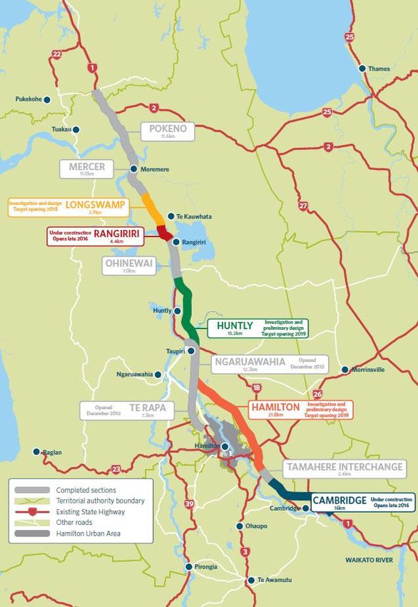
Ruakura Interchange – Notice of Requirement                                                                  ii

        6.3     Tangata Whenua Consultation ....................................................................................... 50
        6.4     Affected Landowner Consultation .................................................................................. 51
        6.5     Ruakura Structure Plan and the Ruakura Development PPC Consultation................... 52
        6.6     Summary ......................................................................................................................... 52

7       Statutory Assessment ....................................................................................... 53
        7.1 Resource Management Act 1991 ..................................................................................... 53
        7.2 National Policy Statements ............................................................................................. 55
        7.3 National Environmental Standards ................................................................................ 56
        7.4 Other Regulations ........................................................................................................... 57
        7.5 Regional Policy and Plans ............................................................................................... 57
        7.6 Plans and Proposed Plans ............................................................................................... 62
        7.7 Other Plans...................................................................................................................... 69
        7.8 Part 2 ............................................................................................................................... 71

8       Conclusion ....................................................................................................... 74

Appendix A – Proposed Conditions

Appendix B – Certificates of Title

Appendix C – Plans in Support of the Alteration to Designation

Appendix D – Network Connections Summary Report – March 2013

Appendix E – TWWG Position Statement

Volume 2 – Specialist AEE Reports

2A - Traffic

2B – Landscape, Visual and Urban Design

2C - Archaeology

2D - Ecology

2E - Vibration

2F - Air

2G - Contamination

2H - Stormwater

2I - Social

2J – Noise

August 2014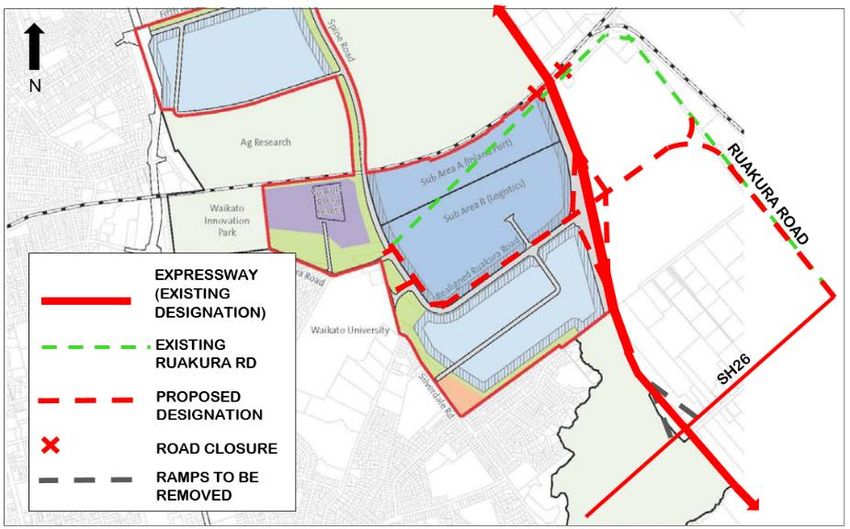
Ruakura Interchange – Notice of Requirement                 iii

Glossary of Terms:

 AEE          Assessment of Environmental Effects
 Agency       New Zealand Transport Agency
 CMP          Construction Management Plan
 GPS          Government Policy Statement on Land Transport Funding 2009/10 – 2018/19
 HCC          Hamilton City Council
 HCV          Heavy Commercial Vehicle
 HPA          Historic Places Act 1993
 LOS          Level of Service
 LTMA         Land Transport Management Act 2003
 NOR          Notice of Requirement
 HNZ          Heritage New Zealand
 NZS          New Zealand Standard
 Opus         Opus International Consultants
 PIR          Project Investigation Report
 PPC          Private Plan Change
 Project      The Waikato Expressway-Hamilton Section
 PT           Public Transport
 PWRPS        Proposed Waikato Regional Policy Statement – also referred to as PRPS
 RLTS         Waikato Regional Land Transport Strategy 2007
 RMA          Resource Management Act 1991
 RoNS         Roads of National Significance
 RPS          Waikato Regional Policy Statement
 SARA         Scheme Assessment Report Addendum
 SH1          State Highway 1
 TDM          Travel Demand Management
 TGH          Tainui Group Holdings Ltd
 TWEAR        Tangata Whenua Effects Assessment Report
 TWWG         Tangata Whenua Working Group
 vpd          Vehicles per day
 WDC          Waikato District Council
 WRC          Waikato Regional Council
 WRP          Waikato Regional Plan
 WRPS         Waikato Regional Policy Statement (Operative) – also referred to as RPS
 WRTM         Waikato Regional Transportation Model

August 2014

Ruakura Interchange – Notice of Requirement 4
1 Introduction
1.1 Overview
The NZ Transport Agency (the Agency) has prepared this Notice of Requirement (NOR) to alter the
designation for the Hamilton Section of the Waikato Expressway (Hamilton Section) in order to
accommodate an interchange at Ruakura, and relocate Ruakura Road. This alteration is required in
response to the Ruakura Development by Tainui Group Holdings (TGH) as described in further
detail later in this report.
This report provides the documentation, including an assessment of environmental effects, to
support the NOR to alter the designation.
1.2 New Zealand Transport Agency
The Agency is a Crown entity, and its objective pursuant to section 94 of the Land Transport
Management Act (LTMA) is to contribute to an integrated, safe, responsive, affordable and
sustainable land transport system. One of the Agency’s current projects is planning for and
delivering Roads of National Significance (RoNS).
1.3 Roads of National Significance
In May 2009, the Government Policy Statement on Land Transport Funding (GPS) was released
which identified seven RoNS, which are considered by the Government to be the country’s most
important transport routes requiring significant development to reduce congestion, improve safety
and support economic growth. The Waikato Expressway is one of the seven RoNS.
The purpose of listing particular roads as nationally significant was to ensure these priority roading
projects are taken into account fully in the development of the National Land Transport Programme.
The Government expects that planning for the future development of the land transport network
should reflect the importance of these roads from a national perspective and the need to advance
them quickly.
Continuing to progress the RoNS (including the Waikato Expressway) has also been identified in the
2012 GPS.
1.4 Waikato Expressway
The Waikato Expressway will extend from the Bombay Hills in the north to just south of Cambridge,
and has been divided into 12 sections (see Figure 1-1). It is expected the Expressway will:
Improve economic growth and productivity for Auckland, Waikato and Bay of Plenty through
more efficient movement of people and freight between Auckland, Hamilton, Tauranga and
Rotorua;
Improve the reliability of the transport network by providing a more robust and safer road
network between Auckland, Hamilton, Tauranga and Rotorua;
Reduce travel times between Waikato and Auckland; and
August 2014Ruakura Interchange – Notice of Requirement 5 Support the growth strategy for the central Waikato. Figure 1-1 – Map of the Waikato Expressway August 2014
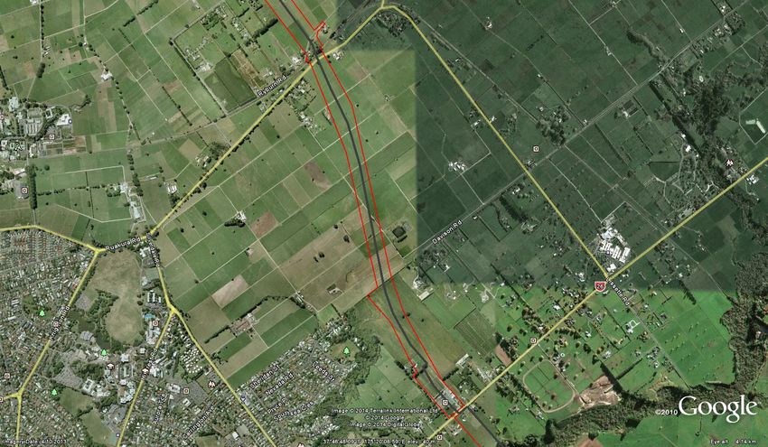
Ruakura Interchange – Notice of Requirement                         6

1.5       Waikato Expressway – Hamilton Section
The Hamilton Section is located on the eastern side of the city of Hamilton. The Hamilton Section
adjoins the recently completed Ngaruawahia Section to the north, and the existing Tamahere
Interchange to the south. It is approximately 22km in length. Figure 1-2 shows the scope of the
Hamilton Section.

Figure 1-2 – Proposed Scope of Works - Waikato Expressway Hamilton Section

August 2014
Ruakura Interchange – Notice of Requirement 7
1.6 Project Specific Objectives
The project specific objectives for the Hamilton Section as set out by the Agency are as follows:
a) Contribute to the GPS priorities of national economic growth and productivity;
b) Take into account the principles of the Treaty of Waitangi;
c) Form part of an ultimate expressway facility between Auckland and Cambridge;
d) Provide a high level of service and safety for inter-regional and inter-centre traffic for a
planning horizon of at least 30 years;
e) Provide for the safe and efficient movement of state highway traffic between Hamilton and
major destinations to the north of Hamilton;
f) Minimise any adverse impacts and improve where feasible, the natural, physical, cultural and
social environment of the region;
g) Provide an appropriate return on investment for the project as a whole; and
h) Maximise the economic viability of the project as measured by its Benefit/Cost Ratio and
general value for money principles.
1.7 Ruakura Interchange – Proposed Alteration
The purpose of this NOR is to alter the existing designation and specifically includes the following:
» Widening of the existing Expressway designation to accommodate the Ruakura Interchange
ramps, connecting roundabouts, and stormwater wetland;
» Closure of the existing Ruakura Road either side of the Expressway and consequently
shortening of the proposed bridge over the East Coast Main Trunk (ECMT) rail line;
» Retention of the existing Ruakura Road either side of the closure at the Expressway in order to
provide continued property access to residents on Ruakura Road, including access to Percival
and Ryburn Roads as currently provided;
» Relocation of Ruakura Road between the Ruakura Road/Silverdale Road intersection and the
existing Ruakura Road near the Vaile Road intersection to connect with the proposed Ruakura
Interchange, including:
Existing Ruakura Road/Silverdale Road intersection closed, with Silverdale Road
terminating in a cul-de-sac (road retained for access) and creation of a new signalised
relocated Ruakura Road/Silverdale Road intersection that will also provide a key access
point to the Ruakura Development Logistics Area;
New relocated Ruakura Road/Existing Ruakura Road (west) priority controlled tee
intersection;
A signalised intersection along the relocated Ruakura Road to provide a second key access
point to the Ruakura Development Logistics Area;
August 2014Ruakura Interchange – Notice of Requirement 8
Provision of a tee intersection where the relocated Ruakura Road meets the existing
Ruakura Road (east);
Upgrading the existing Ruakura Road, largely within its existing boundaries, between the
new intersection with the relocated Ruakura Road (east) and the Ruakura Road/SH26
intersection (this will include shape correction of the roadway, carriageway widening,
provision of a footpath and drainage improvements;
Extension of the designation to cover the existing Ruakura Road (from the intersection
with the relocated Ruakura Road up to SH 26) so upgrading works can be undertaken;
Provision for the relocated Ruakura Road to pass either over or under the Expressway; and
Provision for stormwater attenuation and disposal from the relocated Ruakura Road and
Ruakura Interchange.
Refer to Figure 1-3 below for the Scope of Works. Detailed designation plans are provided as
Appendix C.
Subject to the Ruakura Interchange proceeding, the proposed north facing ramps where the
Expressway passes under SH26 would not be required. Accordingly, a condition is proposed that
would result in the north facing ramps being removed from the Waikato Expressway, once the
Ruakura Interchange is under construction.
The relocated Ruakura Road west of the Expressway will become a local road, whereas the section of
road to the east will become state highway as will the section of existing Ruakura Road through to
State Highway 26.
Figure 1-3 – Scope of Works
August 2014Ruakura Interchange – Notice of Requirement 9
2 Background
2.1 Existing Designations and Conditions
The route selection and alignment of the Hamilton Section was determined as part of a wider project
which commenced in 1995 and covered the long term development of State Highway 1 (SH1) between
Ohinewai and Cambridge. The NoR for the original designation was lodged in 2001 and the
designation was secured in 2005, following an appeal hearing before the Environment Court in
2004.
Key aspects of the designated route are:
The need for the Hamilton Section of the Expressway to provide convenient and efficient
connections to the City's arterial network - as well as providing for the efficient and
uninterrupted passage of inter-regional traffic on the nation's primary trunk route;
A decision by the Agency that the Hamilton Section should pass to the east of Hamilton City -
rather than to the west;
A decision by the Agency confirming that the southern end of the route is to link into the
existing State Highway at Tamahere - rather than link directly into the designated Cambridge
Bypass via an alignment generally following the Cambridge Branch rail line. This issue was
the main focus of the appeal hearing in 2004.
Table 2-1 summarises the existing designations for the Hamilton Section and other existing relevant
designations by the Agency.
District District Code Activity Location Comments
Plan
Map No.
Waikato 1, 3, 4, 8, J1 State Highway 1 (Limited From Franklin
13, 14 access except those parts District/Waikato District
within the former boroughs of boundary north of
Huntly and Ngaruawahia as at Meremere to Hamilton
October 1989, and that part of City/Waikato District
Taupiri between Mangawara boundary at Ruffell Road,
bridge and Kainui Road) and then from Hamilton
City/ Waikato District
boundary at Newell Road to
Waipa District/Waikato
District boundary at
Racecourse Road
Waikato 14, 15, 19 J3 State Highway 26 (limited From Hamilton
access) City/Waikato District
boundary at Matangi Road
to Matamata Piako
District/Waikato District
boundary
Waikato 37, 14, 20, J17 Road for state highway and Lake Road to Bollard Road Designation
22, 24A road for access to state lapses in
highway (Waikato 2015
Expressway, Hamilton
Bypass.)
August 2014Ruakura Interchange – Notice of Requirement 10
District District Code Activity Location Comments
Plan
Map No.
Hamilton 2, 3 90 Hamilton Bypass – State Kay Road to Gordonton Designation
Highway and Access to State Road lapses in July
Highway 2022
Hamilton 20, 21, 30, 90a To manage the State highway Greenhill Road to Designation
31, 40, 48, system, including planning, Mangaonua Gully (rollover lapses in
49 funding, design, supervision, from Waikato District Plan) 2015
construction, and
maintenance and operations,
and improvements in
accordance with the Land
Transport Act 2003 and the
Government Roading Powers
Act 1989.
Table 2-1 – Existing Designations
There are four sets of conditions that currently relate to the existing Hamilton Section designation.
These are:
NOR 1 – Waikato District – Horotiu to Tamahere;
NOR 2 – Hamilton City – Horotiu to Tamahere;
NOR1A – Waikato District – Alterations C, U, V, W, T and Z to designation J17; and
NOR1B – Hamilton City – Alteration W to designation E90A.
The conditions referred as NOR1 and NOR2 were confirmed with the original designation in 2005,
following the Environment Court hearing in 2004. The NOR2 conditions only relate to a portion of
the designated Expressway between Kay Road and Horsham Downs Road. These conditions were
required because at that time only this section of the designated Expressway was located within
Hamilton City, with the balance of the designated Expressway being within the Waikato District.
Since that time, the boundary between the two territorial authorities has changed, but the physical
location of the designations has remained the same. As a consequence, the NOR1 conditions
originally for the designation located within the Waikato District now apply to some of the
designation located within Hamilton City. Only the NOR1 conditions apply to the designations to be
altered by this NOR for the Ruakura Interchange, being J17 –Waikato District Plan, and E90a
Hamilton City Proposed District Plan.
During the 2014 hearing of alterations to designation (refer 2.2 below), a revised set of conditions
was developed, based on those contained in NOR1. The revised conditions are referred to as NOR1A
(for those areas within Waikato District) and NOR1B (for those areas within Hamilton City). It is
proposed that these conditions also apply to the Ruakura NOR, with some specific amendments to
address unique aspects of this alteration. A full set of proposed conditions based on the NOR1A and
NOR1B conditions is provided in Appendix A.
2.2 Alterations to the Designation
On 30 September 2013, the Agency lodged a NOR detailing a series of alterations to the existing
designation. The NOR was divided into two bundles. The first bundle included the following
alterations to the designation, which the Agency requested be publicly notified under s95A(2)(b) of
August 2014Ruakura Interchange – Notice of Requirement 11
the Resource Management Act 1991 (RMA). Accordingly these alterations were notified on 20
November 2013. A total of 18 submissions were received.
Alteration Relevant Council
Resolution Drive Interchange (Alteration U) WDC
Puketaha Road Arrangement (Alteration V) WDC
Greenhill Interchange (Alteration W) WDC & HCC
Southern Interchange and Cambridge Road Widening (Alteration Z) WDC
Table 2-2 – Publicly Notified Alterations
The second bundle included twelve minor alterations providing for local widening at narrow points,
and to make provision for stormwater treatment facilities. These alterations were lodged in a
separate bundle under the expectation that they were likely to be non-notified due to their minor
nature.
The notified alterations were heard by independent Commissioners at a joint hearing in April/May
2014. A recommendation from the Commissioners that the NORs be granted subject to a set of
conditions was released on 30 June 2014. On 8 July 2014, the Transport Agency accepted the
recommendation with only minor modifications. Two appeals have been made by submitters, one
in relation to Alteration U, and the other in relation to Alteration Z. It is anticipated that
recommendations on the non-notified alterations will be provided in early September 2014.
2.3 Resource Consents
On the same date (30 September 2013), the Agency lodged applications for the necessary resource
consents with Waikato Regional Council (WRC). As with the large alterations, the Agency requested
that these applications be publicly notified under s95A(2)(b) of the RMA. Accordingly these resource
consents were publicly notified on 20 November 2013.
The WRC consents were heard at the same time as the notified alterations. The Commissioners’
decision to grant the resource consents was notified on 1 July 2014. No appeals were made in relation
to these consents.
The following resource consents were granted by the WRC:
Land use Undertake earthworks including: soil disturbance, roading, tracking, and
vegetation clearance both within and outside of high risk erosion areas;
AUTH130361.01 cleanfill and overburden disposal; and, any associated discharges of
contaminants to water or air association with the Hamilton Section of the
Waikato Expressway
Water permit To dam and divert surface water in the Mangaonua and Mangaharakeke/
Mangaone gullies as a consequence of road construction in association with
AUTH130361.02 the Hamilton Section of the Waikato Expressway
Land use Construction, operation, maintenance and removal of temporary bridges
over the Mangaonua and Mangaone streams including any associated
AUTH130361.03 discharges of contaminants to water or air in association with the Hamilton
Section of the Waikato Expressway
August 2014Ruakura Interchange – Notice of Requirement 12
Land use Construction, operation and maintenance of the Mangaonua and Mangaone
Stream bridges including any associated discharges of contaminants to
AUTH130361.04 water or air in association with the Hamilton Section of the Waikato
Expressway.
Water Permit To drill below the water table to install bridge piles in association with the
Hamilton Section of the Waikato Expressway.
AUTH130361.05
Water permit To take and divert groundwater and discharge groundwater to water in
association with the Hamilton Section of the Waikato Expressway.
AUTH130361.06
Discharge To divert and discharge stormwater into water, and/or into or onto land,
permit including the installation, operation and maintenance of discharge
structures in association with the Hamilton Section of the Waikato
AUTH130361.07 Expressway.
Land use Construction, operation and maintenance of culverts including any
associated discharges of contaminants to water or air in association with the
AUTH130361.08 Hamilton Section of the Waikato Expressway
Water Permit To dam and divert surface water in association with culvert construction,
operation and maintenance
AUTH130361.09
Table 2-3 – WRC Consents Granted
2.4 Summary of Alterations and Resource Consents
The alterations to the existing designations and the WRC resource consents granted as outlined
above do not specifically address the Ruakura Interchange proposal with the exception of the
following resource consents:
Earthworks associated with the interchange and ramps (AUTH130361.01);
Drilling to install bridge piles (AUTH130361.05); and
Diversion and discharge of stormwater associated with the interchange ramps
(AUTH130361.07).
Accordingly, there is a requirement to seek a separate alteration for the Ruakura Interchange and
connecting roads, and resource consents associated with stormwater discharges not covered by the
existing WRC consents.
August 2014Ruakura Interchange – Notice of Requirement 13
3 Planning Context
3.1 Local Authority Boundary Changes
Since the original designation was confirmed, boundary changes have occurred between HCC and
WDC as set out in the Strategic Agreement on Future Urban Boundaries, dated March 2005. The
agreement identified the principles, direction and process for transfer of land.
In relation to the Ruakura Interchange NOR, the jurisdictional boundary generally follows the
centreline of the Expressway from Greenhill Road through to the Mangaonua Gully. The NOR is
therefore being made to both the WDC and HCC.
EXISTING
HAMILTON
SECTION
N DESIGNATION
HCC/WDC
BOUNDARY
Figure 3-1: Local Authority Boundary
3.2 Ruakura Structure Plan
Boundary changes between HCC and WDC have meant that a significant area of land at Ruakura is
now within the jurisdiction of HCC. The development of this land is identified in a number of high
level documents including: the Hamilton Urban Growth Strategy, the Access Hamilton Transport
Strategy and the Waikato Proposed Regional Policy Statement.
To enable the progressive development of this area, the Ruakura Structure Plan (RSP) was developed
and notified as part of the Hamilton City Proposed District Plan (PDP) in December 2012. The RSP
(as notified) includes an inland port, freight and logistics hub and other industrial land. The inland
port as proposed in the RSP has an intermodal facility so that freight can be transferred to and from
road and rail. The RSP also provides for research and innovation activities, and residential areas for
an eventual population of approximately 1,800 households, including the development of a
neighbourhood centre.
August 2014Ruakura Interchange – Notice of Requirement 14
Submissions and further submissions have been received on the RSP, however hearings and a
decision have been deferred, pending the outcome the Ruakura Development Private Plan Change
(PPC) (refer 3.3 below).
3.3 Ruakura Development Private Plan Change
Tainui Group Holdings Limited (TGH) is the predominant landowner affected by the RSP. It was
identified that rules in the Hamilton District Plan: Waikato Section (as transferred over from the
WDC’s District Plan) prohibit any application being made for urban development within this area.
Given that the WDC rules are currently operative, they continue to apply until the PDP (including
the RSP) is made operative. Given the potential for lengthy delays, TGH have sought a PPC for what
is known as the Ruakura Development, through the Environmental Protection Authority (EPA). The
PPC affects some, but not all, of the land subject to the RSP.
The PPC does not re-zone any land, rather it proposes to adopt mechanisms providing an overlying
‘schedule’. This allows a range of activities to be undertaken in identified areas, as well as existing
rural activities.
The key aspects of the PPC are as follows:
A new ‘Schedule 25H Ruakura’ inserted into Chapter 25: Rural of the PDP, which provides a
Ruakura Logistics Area (incorporating the Inland Port), Ruakura Industrial Park Area,
Knowledge Area, Residential Areas and Open Space Areas along with indicative roads (refer to
Figure 3-2 below).
Amendments to the Prohibited Activity rules to enable the planning and development of the land
covered by Schedule 25H, including the future roading network.
On 31 July 2013, a ministerial direction was released, referring the PPC request to a Board of Inquiry
(BOI) which was held over a number of weeks during May/June 2014. On 5 August 2014, the BOI
issued its draft decision approving the PPC, subject to a number of amendments to the proposed
objectives, policies and rules, as they would apply to the Ruakura Development. Comments on the
draft decision close during the week commencing 1 September 2014, and a final decision is due on
11 September 2014.
The PPC will enable development to occur in the interim, but it is intended that the PPC will also be
incorporated into the framework of the PDP, once the PPC has been confirmed. Accordingly, the
RSP contained within the notified PDP is likely to be superseded by the Board’s decision on the PPC.
August 2014Ruakura Interchange – Notice of Requirement 15 Figure 3-2: Ruakura Schedule Area as approved by the BOI in its draft decision August 2014
Ruakura Interchange – Notice of Requirement                          16

3.4 Ruakura Interchange Notice of Requirement
The functioning of the Ruakura Development as provided for by the PPC requires the establishment
of a full diamond interchange on to the Hamilton Section of the Waikato Expressway. Accordingly,
in February 2014 the Agency lodged a NOR to alter the designations for the Hamilton Section to
provide for the required interchange, and also to provide appropriate arterial roads linking land to
the east and west of the Expressway to the interchange. The NOR was lodged to provide surety for
the BOI process, and demonstrate that the Agency was committed to establishing the Interchange.
At the Agency’s request, that NOR application was immediately placed on hold pending the outcome
of the BOI process for the PPC. Now that an interim decision has been made approving the PPC, the
Agency has amended the NOR as lodged to be cognisant of the BOI decision, and seeks to have it
publicly notified by the HCC and WDC.

August 2014
Ruakura Interchange – Notice of Requirement                               17

4         Ruakura Interchange
The Agency is seeking to alter the existing designations for the Waikato Expressway (Hamilton
Section) in order to accommodate an interchange at Ruakura. This includes the relocation of
Ruakura Road, closing the existing Ruakura Road where it passes under the existing designation,
removing the two north facing ramps at the SH26/Morrinsville Road interchange, and providing for
stormwater drainage along Davison Road1. The NOR will enable a direct link between the Inland
Port/Logistics and Industrial Areas of the Ruakura Development to the Hamilton Section of the
Waikato Expressway, rather than relying on local roads to accommodate heavy vehicle movements.

4.1       Form 18
Section 181 Resource Management Act 1991

To:       Waikato District Council
          Private Bag 544
          Ngaruawahia

And       Hamilton City Council
          Private Bag 3010
          Hamilton

1         The NZ Transport Agency (the Agency), a requiring authority pursuant to section 167 of the
          Resource Management Act 1991, and having financial responsibility for this proposed public
          work, gives notice to both Waikato District and Hamilton City Councils of a requirement for
          alterations to the following designations:
          J17 (Hamilton Bypass) of the Waikato District Plan; and
          90a (Hamilton Bypass) of the Hamilton City Proposed District Plan.

          Designation Purpose:
          Alteration to J17: Road Purposes – Road for State Highway & Access to State Highway

          Alteration to 90a: To manage the State highway system, including planning, funding,
          design, supervision, construction, and maintenance and operations, and improvements in
          accordance with the Land Transport Act 2003 and the Government Roading Powers Act
          1989

          Designation Lapse Period:
          Waikato District Plan – 2015
          Hamilton City Proposed District Plan – 2022

2         The site to which the requirement applies is as follows:
          Waikato District
          Lot 3 DPS14267 (SA11D/1380),

1For the avoidance of doubt, the designation of Davison Road is to provide for stormwater drainage only, and
there is no requirement to designate this road for State highway purposes.

August 2014
Ruakura Interchange – Notice of Requirement 18
Lot 8 DPS66853 (SA53C/665); and
Road Reserve – Ruakura Road, Vaile Road and Davison Road
Hamilton City
Lot 1 DPS77458 (SA61C/243),
Lot 8 DPS66853 (SA53C/665); and
Road Reserve – Ruakura Road and Silverdale Road
Please refer to Appendix B for copies of the Certificates of Title.
3 The nature of the alteration work is as follows:
» Widening of the existing Expressway designation to accommodate the Ruakura
Interchange ramps, connecting roundabouts, and stormwater wetland;
» Closure of the existing Ruakura Road either side of the Expressway and
consequently shortening of the proposed bridge over the East Coast Main Trunk
(ECMT) rail line;
» Retention of the existing Ruakura Road either side of the closure at the Expressway
in order to provide continued property access to residents on Ruakura Road,
including access to Percival and Ryburn Roads as currently provided;
» Relocation of Ruakura Road between the Ruakura Road/Silverdale Road
intersection and the existing Ruakura Road near the Vaile Road intersection to
connect with the proposed Ruakura Interchange, including:
Existing Ruakura Road/Silverdale Road intersection closed, with Silverdale
Road terminating in a cul-de-sac (road retained for access) and creation of a
new signalised relocated Ruakura Road/Silverdale Road intersection that will
also provide a key access point to the Ruakura Development Logistics Area;
New relocated Ruakura Road/Existing Ruakura Road (west) priority
controlled tee intersection;
A signalised intersection along the relocated Ruakura Road to provide a second
key access point to the Ruakura Development Logistics Area;
Provision of a tee intersection where the relocated Ruakura Road meets the
existing Ruakura Road (east);
Upgrading the existing Ruakura Road, largely within its existing boundaries,
between the new intersection with the relocated Ruakura Road (east) and the
Ruakura Road/SH26 intersection (this will include shape correction of the
roadway, carriageway widening, provision of a footpath and drainage
improvements;
Extension of the designation to cover the existing Ruakura Road (from the
intersection with the relocated Ruakura Road up to SH 26) so upgrading works
can be undertaken;
Provision for the relocated Ruakura Road to pass either over or under the
Expressway; and
August 2014Ruakura Interchange – Notice of Requirement 19
Provision for stormwater attenuation and disposal from the relocated
Ruakura Road and Ruakura Interchange.
Please refer to Appendix C for plans in support of the NOR.
4 The nature of the proposed restrictions that would apply are:
In the context of the assessment of environmental effects that follows, it is considered that
the existing conditions applying to the altered designation for the Hamilton Section of the
Waikato Expressway (NOR1A and NOR1B), will adequately mitigate any potential
environmental effects associated with the alteration. Further conditions are also proposed
that are unique to this alteration.
A full set of proposed conditions based on the NOR1A and NOR1B conditions is provided in
Appendix A of this report.
5 The effects that the public work will have on the environment and the ways in which any
adverse effects will be mitigated are:
Please refer to the effects assessment in section 5.0 below.
6 Alternative sites have been considered to the following extent:
Please refer to the alternatives assessment in section 4.2 below.
7 The public work and designation are reasonably necessary for achieving the objectives of the
requiring authority because:
The proposed alteration is the outcome of a Network Connections investigation which
concluded that interchanges at Greenhill and Ruakura best served the area if the Ruakura
Structure Plan and in particular the Inland Port were to proceed. The draft BOI decision
has given approval to the Ruakura Development PPC, which will be incorporated into the
RSP. Accordingly, the alteration will achieve the Agency’s project specific objectives: a), d)
and e), as listed under section 1.6 of this report.
The use of a designation is necessary as it is consistent with the approach across the wider
Expressway, including the Hamilton Section.
8 The following resource consents are required from the Waikato Regional Council:
The Transport Agency is also seeking additional resource consents from the WRC to
construct, operate and maintain the connecting roads (being the relocated and existing
Ruakura Road). The interchange ramps and associated earthworks are covered by the
existing consents granted 1 July 2014. Water and discharge permit applications will be
lodged with the WRC shortly.
9 The following consultation has been undertaken with the affected landowners:
Consultation undertaken by the Agency with respect to this NOR is detailed in Section 6 of
this report.
10 The following information is required to be included in this notice by the district plan,
regional plan, or any regulations made under the Resource Management Act 1991:
Notice of requirement assessment of effects;
Notice of requirement alteration plans.
August 2014Ruakura Interchange – Notice of Requirement 20
4.2 Consideration of Alternatives
In early 2013, transport modelling work was undertaken to inform a network connections study to
ascertain the most favourable network between Greenhill Road and SH26, with a view to integrating
the Waikato Expressway connectivity with the proposed RSP and associated generation of a large
number of heavy commercial vehicle movements.
The study identified that interchanges at Greenhill and Ruakura best served the area if the RSP and
in particular the Inland Port were to proceed. The draft BOI decision has given approval to the
Ruakura Development PPC, which the HCC has advised will be incorporated into the RSP.
The outcomes of the assessment were discussed with HCC, WDC and TGH (and generally accepted
as appropriate) prior to being subject to the Agency’s internal approval process.
The full assessment of options between Greenhill Road and SH26 is contained in the report ‘Network
Connections Summary Report – March 2013 Update’, prepared by Opus and attached as Appendix
D to this report.
In addition to the Network Connections assessment, consideration has been given to network
connectivity to the east of the Ruakura interchange. In particular, how to connect the re-aligned
Ruakura Road back to the existing network. Two alternatives were considered:
Option 1: (the proposed option) connection into the existing Ruakura Road; or
Option 2: connection to SH26 via a new road, running parallel to the Expressway.
The process has included a multi criteria approach, giving consideration to both economic efficiency,
strategic fit, environmental effects, safety and accessibility. Property impacts, geometric design
requirements and road safety matters were of particular interest in this case.
Option 2 was not chosen because:
The length of an alternative alignment (Option 2) is 3 km, and would require the taking of
about 7.5 ha of land.
The alternative alignment cannot run directly alongside the expressway because:
o The design speed of the curves on the new road needs to be 80km/h, that is, the curves
need to have radii in excess of 230 m, and
o The intersection with the relocated Ruakura Rd that crosses the interchange needs to
be separated from the eastern ramp terminal roundabout by about 300 m to meet
sight distance requirements.
The alternative alignment results in a much greater property impact than that created by
Option 1.
The intersection with SH26 (Morrinsville Rd) needs to be separated from the expressway
bridge to meet sight distance requirements and to avoid widening the bridge.
This significantly increase the impact on properties fronting SH26 in the vicinity compared
with Option 1. Option 1 requires no widening of the expressway bridge.
August 2014Ruakura Interchange – Notice of Requirement 21 In addition, Option 1 provides the opportunity to make use of the existing Ruakura Road, which is an existing resource, and a road of a suitable status on the road hierarchy for connection, being classified as an Arterial Road in the Waikato District Plan. August 2014
Ruakura Interchange – Notice of Requirement                                22

5         Assessment of Environmental Effects
This section of the report provides an assessment of the actual and potential effects on the
environment as a result of giving effect to this alteration. The effects assessment is based on the
various specialist reports used to inform this assessment. A full copy of all specialist assessments is
provided in Volume 2 of this report.

5.1       Baseline for the Environmental Effects Assessment
The RMA requires an assessment of the effects on the environment of allowing the requirement
(s171(1)). Consideration therefore needs to be given to what defines the existing environment, as this
will form the baseline that the effects of the proposal will be assessed against.

5.1.1         Waikato Expressway

The Hamilton Section of the Waikato Expressway designations pass to the east of Hamilton City in
a generally north-south direction and enable the construction of a four-lane Expressway and
associated on/off ramps to connect with the local road network (excluding the Ruakura Interchange).
The development of the Expressway is also supported by a number of consents granted by the WRC
as detailed in section 2.3 of this report. For the purpose of assessing this NOR, the Expressway as
currently designated is considered part of the existing environment.

5.1.2         West of the Expressway

The land immediately to the west of the Expressway is currently zoned Rural in the Hamilton District
Plan: Waikato Section. This area adjoining the Expressway is in pasture, with scattered dwellings
and farm buildings. The Waikato University is located to the west of Silverdale Road, and is
surrounded by residential development. There is also residential development to the east of
Silverdale Road, which juts out towards the Expressway and is bounded by a gully (Nevada Road).
North of Ruakura Road is an area of land zoned Country Living, which contains a cluster of
approximately 30 rural residential dwellings.

The environment immediately to the west of the Expressway is subject to a PPC, which a BOI has
approved in its draft decision. Consideration of this NOR by the territorial authority should be in
the context of the future development enabled by the PPC. The need for the Ruakura Interchange is
a direct result of development occurring in this area in accordance with the PPC. Without the PPC
proceeding, the Agency would revert back to the approved north facing ramps at SH26, unless an
alternative justification was provided for establishing an interchange at Ruakura.

It is reasonable to assume that the existing environment for the purpose of assessing the effects of
this NOR will consist of the land use activities indicated in Figure 3-2 of this report, and supported
by the BOI decision2. The BOI has already heard evidence in relation to the associated effects of these
land use activities and their ruling on the PPC has taken such effects into consideration.

2At the time of lodging this NOR only a draft decision on the Ruakura Development PPC was available, with
the final decision scheduled to be issued on 11 September 2014. It has been assumed that any changes to be
made between the draft decision and final decision will have no material bearing on the existing environment
as applied to this NOR. This will be confirmed once the final decision on the PPC is made, and if necessary
the NOR will be amended to reflect any changes.

August 2014
Ruakura Interchange – Notice of Requirement 23 As stated in section 3.3 of this report, the PPC will enable development to occur in Ruakura ahead of the RSP being approved, and it is intended that the PPC will be incorporated into the framework of the PDP, superseding aspects of the RSP pertaining to this area. It is for this reason that for the purposes of this effects assessment the PPC has been adopted as the existing environment, rather than the RSP. The PPC adds Schedule 25H Ruakura to Chapter 5 of the PDP and includes the following features: Ruakura Logistics Area (including Inland Port) Industrial Park Areas Knowledge Area Ruakura Retail Area Medium Density Residential Areas General Residential Areas Open Space Areas Schedule 25H includes objectives, policies, rules and other methods that will provide for the Ruakura Development and manage any effects associated with activities locating in this area. The Ruakura Logistics Area, Industrial Park Area, and Open Space Area are all located in close proximity to the Ruakura Interchange and are described below. Ruakura Logistics Area A key aspect of the Ruakura Logistics Area is its proximity to the Waikato Expressway, ECMT and Wairere Drive, making its location well suited to the distribution of freight by road and rail. The Ruakura Logistics Area is divided into two sub-areas being the Inland Port (Sub-Area A) and Logistics (Sub-Area B). The purpose of Sub-Area B is to provide a distribution precinct, which naturally sits adjacent to the Inland Port. Initially, freight will only be transported by road to the Inland Port. In time, rail freight will also be handled, but this will require the construction of railway sidings. Construction of the sidings will require the stopping of the existing Ruakura Road to the west of the Expressway. This can only occur once the Ruakura Interchange and link roads east and west of the Expressway are constructed. The road closure will also be subject to a separate process under the Local Government Act 1974. Industrial Park Area One of the Industrial Park Areas will be located in the southern end of the Ruakura Development, opposite the Logistics Area. It is anticipated that the Inland Port and Logistics Area will provide incentives for industry and services to establish in this area. The proximity of the Expressway, AgResearch, University of Waikato and Innovation Park will also attract industrial business to the area. The rule regime will encourage industry that is complementary to other activities in the area, and discourage noxious and offensive industries deemed to be incompatible with those same activities. The Industrial Park Area in this location also envisages the inclusion of a transportation service centre, given its close proximity to the Ruakura Interchange and Expressway. August 2014
Ruakura Interchange – Notice of Requirement 24 Open Space Areas The primary function of the Open Space Areas is to provide stormwater and ecological management areas, as well as corridors for existing electricity transmission lines. The Open Space Areas will also provide for pedestrian/cycle networks, amenity for new developments, landscaped buffers for existing residential areas, the University and AgResearch from the Logistics and Industrial areas. Open Space Areas will also be located adjacent to parts of the relocated Ruakura Road that form part of the NOR. Staging of Development A first stage planning process has been established through the PPC requiring that a Land Development Plan be approved for large blocks of land before individual activities are able to be developed within those blocks. The purpose of the Land Development Plans is to ensure that appropriate consideration is given to Three Waters infrastructure, transport effects, ecological effects and provision of open space at a macro level. The relocated Ruakura Road that forms part of the NOR passes through three Land Development Areas listed as areas A, C and F on Figure 25H(3) of the Plan Change. The PPC includes a plan3 indicating the year at which certain aspects of the Ruakura Development will be established. Whilst that plan is only intended as a guide, it demonstrates that development will take place over a number of years. Based on the dates indicated, the Ruakura Interchange could be constructed ahead of some aspects of the Logistics and Industrial areas. Accordingly, the effects assessment for the Ruakura Interchange also needs to consider any temporary effects created by the staged development, rather than assuming only a fully completed Ruakura Development forms the existing environment. 5.1.3 East of the Expressway The land to the east of the Expressway is zoned Rural in the Waikato District Plan. The portion of land between the ECMT line and Davison Road is characterised by large open paddocks and scattered buildings, including some dwellings. From Davison Road south, there is significantly more rural-residential development. The Dairy NZ/LIC site is located on the corner of Ruakura Road and SH26, comprising of office space and facilities associated with the rural services they provide, and staff up to 350 people. Ruakura Road itself is identified as an Arterial Road in the Waikato District Plan (WDP). The function of Arterial Roads is described in the WDP as roads that: Form a strategic network of regional importance Provide for the collection and distribution of goods significant to the regional economy Rural roads that typically provide for more than 2,500 vehicle movements per day Include rest areas; and The through traffic function predominates. 3Indicative Development Timeframes Plan (25 September 2013) – Appendix 6 to the Proposed Ruakura Development Plan Change Draft Decision and Report, 5 August 2014 August 2014
Ruakura Interchange – Notice of Requirement 25
5.1.4 Existing Environment Summary
The following sections of this report includes a summary of the potential environmental effects
associated with the Ruakura Interchange and any subsequent mitigation that is proposed. Specialist
assessments covering the following topics have been prepared, and a full copy of each of those
assessments is included in Volume 2 of this report:
Traffic Effects
Landscape, Visual Amenity and Urban Design Effects
Archaeological Effects
Ecological Effects
Vibration Effects
Air Quality Effects
Contamination Effects
Stormwater Effects
Social Effects
Noise Effects
The effects assessment is based on an existing environment as described above in sections 5.1.1 –
5.1.3.
5.2 Traffic Effects
The potential traffic effects of the Ruakura Interchange and relocated Ruakura Road have been
assessed by a Transportation Engineer familiar with the Expressway project and site. The potential
effects and proposed mitigation are summarised below.
Baseline for Traffic Effects Assessment
Careful consideration has been given to the traffic assessment baseline. A detailed description of the
baseline that has been adopted is set out in section 2 of the traffic assessment report. The traffic
assessment takes into consideration the Ruakura Development when determining the 2021 and 2041
existing traffic baseline. The baseline for the traffic assessment is as follows:
Landuse will reflect that shown on Figure 3-2 above with the associated traffic generation as
prescribed in the Ruakura Development PPC and presented in evidence during the BOI.
The baseline road network will reflect the road hierarchy as outlined and examined during the
BOI. Although this indicates a realigned Ruakura Road between Silverdale Road and the
Expressway, the existing Ruakura Road can remain open when the Inland Port and Logistics
Area is developed under the Stage 1 rules. Hence, in the traffic baseline the Inland Port and
Logistics Area connect to the wider network (Holland Road and SH26) via the western section of
Relocated Ruakura Road and the existing Ruakura Road.
Intersection upgrades at Knighton and Silverdale roads to traffic signals. These upgrades were
considered in detail during the BOI, and both lie within the PPC area on which the BOI has made
its draft decision.
August 2014Ruakura Interchange – Notice of Requirement 26 Assessment The traffic assessment includes consideration of traffic flows on the network, intersections, existing property access, alternative modes of travel, and construction traffic. The intersections assessed are Ruakura Interchange on/off ramp terminals, existing Ruakura Road/SH26, relocated Ruakura Road/existing Ruakura Road (east), relocated Ruakura Road/Silverdale Road/Port Access, relocated Ruakura Road/existing Ruakura Road (west), existing Ruakura Road/Vaile Road/Davison Road, and relocated Ruakura Road/Port Access East. Property access is considered on Ruakura Road and SH26, and on Percival Road and Ryburn Road. The key conclusions of the traffic assessment are set out below. The proposal encourages traffic to use the expressway, which reduces traffic on local roads such as Wairere Drive, Cambridge Road and the future Spine Road which travels through a residential area. It also reduces traffic past the Silverdale School and removes about 300 daily trucks (yr 2041) from Silverdale Road. All NOR intersections are expected to operate at least as well as the baseline with little difference in traffic performance. They also meet the Project and Ruakura Development Level of Service criteria at opening through to year 2041 during all peak periods. Overall safety of the existing intersections on relocated Ruakura Road and Ruakura Road is expected to be no worse with the NOR than will occur under the baseline. Any new crashes on Relocated Ruakura Road as a result of the two roundabouts at the interchange ramp terminals will most likely be offset by the removal of potential crashes on SH26, as a result of not constructing the two Tee Intersections at the SH26 ramp terminals. There is also a significant number of vehicles that are transferring from the local road network to the expressway which should provide a safety benefit for the remaining traffic using the local road network. The extra traffic on Ruakura Road will be accommodated on a widened cross section that provides two 3.5m lanes with 1.5m shoulder widths. A right turn bay for Vaile/Davison Road intersection will provide a safer environment for turning vehicles than is offered by the existing intersection. Effects on alternative modes of transport are expected to be positive due to the inclusion of shared off road facilities along Relocated Ruakura Road, and a concrete pathway between Vaile Road and SH26, neither of which exist at present. There are no expected effects on public transport. No more than a minor effect on property access for Ruakura Road residents (south of Vaile Road) is expected, despite the increased traffic flows. Residents turning into, or out of, their properties should not be adversely affected by the increased traffic as it represents on average an extra vehicle every 30 seconds during the day. The inclusion of a central painted median for right turn traffic into LIC/Dairy NZ site will ensure a much safer environment than exists at present. Network effects for travel to the south and east for Percival and Ryburn Road residents are not expected to be more than minor when the increased trip time (between 1 minute to 2.5minutes) is compared with the overall trip time, and given that the number of these trips is expected to be less than 20% of their total daily trips (on average). Construction traffic effects relate to the additional earthworks required to construct the proposed works. A Construction Management Plan (CMP) developed by the contractor as a condition to this NOR will set-out the mitigation measures proposed to deal with any adverse traffic or safety effects August 2014
You can also read