WALK AND RIDE IN CASEY 2019-2041 - City of Casey
←
→
Page content transcription
If your browser does not render page correctly, please read the page content below

WALK AND RIDE IN
CASEY
2019-2041
Governance Information

Approval Body             Council

Endorsement Date          3 December 2019

Current Version           Version 1.0
                          Council policy documents change from time to time and it is recommended to consult the
                          electronic reference copy on Casey Council’s website to ensure to have the current version.
                          Alternatively, you may contact Customer Service on 9705 5200

Compulsory Review Cycle   4 years

Review Date               3 December 2023
                          It is recognised that, from time to time, circumstances may change leading to the need for
                          minor administrative changes to this document. Where an update does not materially alter this
                          document, such a change may be made administratively

                          Examples include a change to the name of Council department, a change to the name of a
                          Federal or State Government department, and a minor update to legislation which does not
                          have a material impact. However, any change or update which materially alters this document
                          must be by resolution of Council

Responsible Department    City and Asset Planning

Relevant Legislation      Casey 21, Casey Council Plan, Municipal Public Health and Wellbeing Plan, Open Space
                          Strategy, Transport Strategy
ECM ID                    13361854
Contents                            4. Strategic Objectives                   8 - 17

1.      Introduction            4    Strategic Objective 1:
                                     Linked path network to local services    9 - 11
     1.1 Background             5
                                     Strategic Objective 2:
                                     Connected Green City                    12 - 14
     1.2 Strategic Context      6
                                     Strategic Objective 3:
     1.3 Community Engagement   7    Beyond Casey                                 15
                                     Strategic Objective 4:
2. Vision                       8    Smart Trails                                 16
3. Strategic Principles         8    Strategic Objective 5:
                                     Give it a go                                 17
     3.1 Forward Thinking           5. Action Plan                           18 - 20

     3.2 Connect                    6. Estimated Cost                        21 - 23

     3.3 Adapt                      7. Monitoring and Evaluation                 24

     3.4 Prioritise                 8. Appendix                              25 - 29

                                     Operational Examples                        26

                                     Classifications and Design Elements     27 - 29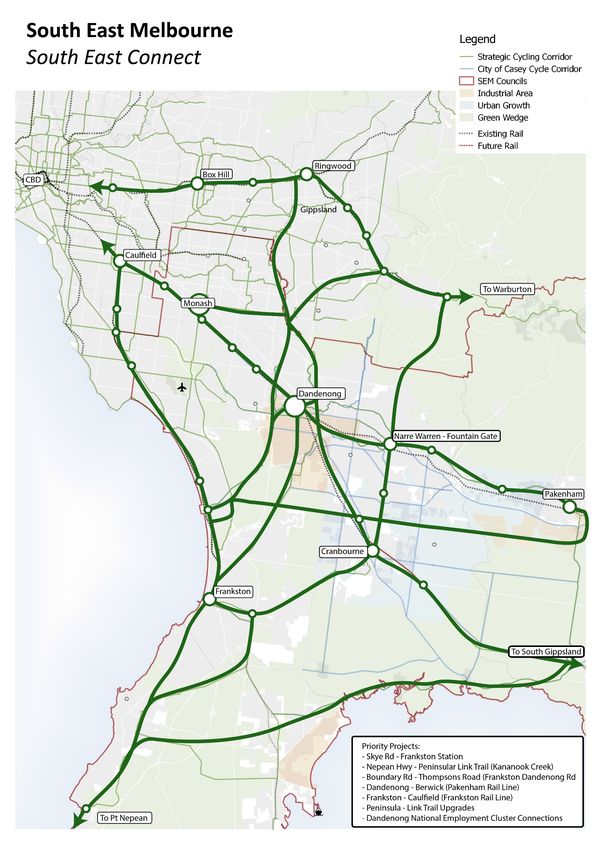
1. Introduction
The City of Casey is one of the largest and fastest-growing municipalities in Victoria and Australia. By 2041
our population is forecast to grow to 549,190 residents, calling for the need to be prepared for the physical,
social and economic changes associated with rapid growth.
Our community is faced with significant challenges to walk and ride within the municipality. This creates an
opportunity for the City of Casey to positively improve the health, wellbeing and liveability for our residents
and visitors through a connected path network.
The Walk & Ride in Casey Strategy (the Strategy) provides guidance and direction to plan and deliver
footpaths, shared paths, bicycle lanes and separate lanes that allow our community to freely commute and
recreate on a connected path network that eases the challenges associated with our growing population. The
challenges include:
Traffic congestion Social isolation
Climate change Perception of safety
Technology dependency Lag in infrastructure delivery
The Strategy includes the activities of walking, running, wheeled activities such as riding, scooting, roller
blading and skate boarding, and use of mobility aides including wheelchairs, walking frames and electric
scooters.
The provision of a quality path network increases the options for community members of all ages and abilities Population for 2019: 356,555
to access local services, parks, trails, wetlands, creek corridors, sport and leisure facilities. This is key to
increasing physical activity, improving mental health, creating social connections and reducing car
dependence as well as increasing options for community members to access to education, employment and Population expected by 2041: 549,190
social activities.
The Strategy understands and prioritises investment in the missing links required to create improved local
and regional connections for the current and future path network within the Casey and with neighbouring
council networks.
4
1.1 Background
The City of Casey is highly reliant on car travel. We have the highest rate of car ownership per
household in Victoria, which results in congested roads, long travel times and increased
environmental impact of cars commuting within our City.
In terms of health and wellbeing in the City of Casey:
25.2% of Casey residents are obese.
29.1% are overweight (Victorian Population Health Survey 2014).
21.9% or one in five do less than 30 minutes of physical activity per week.
Children and young people have identified barriers to walking and riding. ‘Casey’s Future – A Plan
for Children, Young People and Families 2017-2021’ consultation revealed:
That children “enjoy a wide range of activities such as walking the dog, playing, family
holidays, visiting playgrounds and parks”, however “they are worried that the roads are busy
and dangerous”.
That young residents find “Transport and time are a barrier to them to accessing programs in
the community”, and “they think Casey should have better public transport and less traffic”.
Walk and Ride in
Casey Strategy
Community members may not be able to drive, choose not to drive or not be able to access a
provides strategic
vehicle. These people include: guidance to
Children and young people. deliver improved
Elderly residents. infrastructure to
People with a disability. encourage our
Residents who are not able to afford and maintain a car. residents to walk
and ride more
Walking, bicycle riding, using a scooter, rollerblading, skateboarding, pushing a pram/stroller, and
using a wheelchair, frame or electric scooter are things all members of our community can and are
likely to do, cost very little, however are reliant on paths in good condition and a connected network.
An extensive investigation into the missing links within the path network has provided Council with
the required data to plan and prioritise for the future needs of walking and riding in the City of Casey.
5
1.2 Strategic Context
The City of Casey’s policies, strategies and plans demonstrate commitment to improving
the health and wellbeing of residents through well-planned facilities and services.               Casey C21 –                    Casey                             Municipal
Establishing and understanding the role and relationship of this Strategy to Council’s                                                                           Public Health
other key documents ensures its consistency and contribution.                                      Building a                 Council Plan
                                                                                                                                                                 and Wellbeing
                                                                                                   Great City                  2017-2021                        Plan 2017-2021
The ‘Casey 21 Building A Great City 2011’, ‘Casey Council Plan 2017-2021’ and
‘Municipal Public Health and Wellbeing Plan 2017-2021’ articulate Council’s vision and
the overarching framework used to make key decisions and deliver service priorities.
Sport and leisure facilities are featured as important infrastructure in delivering on the
Council Plan vision ‘Creating Australia’s Most Liveable City’ and strategy ‘The
destination for arts, culture, sport and leisure that attracts visitors and brings
communities together’. Council’s ‘Open Space Strategy’ and ‘Leisure Facilities                                  Planning and Development Principles
Development Plan Policy’ guide planning and decision making in the open space,
recreation and sport area.
The ‘Walk and Ride in Casey Strategy’ replaces the ‘Paths and Trails Strategy’ adopted
by Council in 2012. In the previous version, guidance for shared use paths and bicycle
lanes infrastructure were addressed. In the new version, wider infrastructure such as                              Walk and Ride in Casey Strategy
footpaths, shared paths, bicycle lanes and separate paths, have been included to
understand and plan for the entire path network for walking and riding in the
municipality.
The Strategy does not inform infrastructure for cycling or skateboarding as an organised
sport or for equestrian trails. These are planned for in Council’s ‘Leisure Facilities
Development Plan Policy’, ‘Sport Cycling Strategy’, ‘Skate Strategy’ and ‘Casey
Equestrian Strategy’.                                                                                                       Leisure Facilities
                                                                                               Community                                                              Demographic
                                                                                                                             Development
The Strategy aligns to the first objective of City of Casey’s ‘StreetsAhead - Integrated     Engagement Plan                   Plan Policy                              Profile
Transport Strategy’. ‘StreetsAhead’ provides guidance for a connected and safe path
network so residents of all ages can incorporate active transport into their daily journey                                                         StreetsAhead
and help reduce traffic stress on roads.                                                                       Open Space
                                                                                                                Strategy                             Integrated
                                                                                                                                                 Transport Strategy

                                                                                                                                                                                    6
1.3 Community Consultation
The Walk and Ride in Casey Strategy is underpinned by                                                             Community Engagement
consultation with the Casey community and external stakeholders.

The ways that Council engaged with people included:

• Phone Interviews: with 427 householders, comprising 1,000
  individuals (inclusive of other family members in the household).   Phone interviews                                                                           Focused groups
                                                                                                       Online Survey                  Pin the Map
  The consultation process was part of the National Cycling
  Participation Survey (NCPS). NCPS is a standarised survey that
  has been repeated biennially since 2011 and allows Council to          427 households               55 respondents provided feedback completing              5 representatives from
  benchmark against other Local Government Areas. Council             interviewed comprising           a survey and using an interactive tool on                  advocacy groups
  added extra questions to the consultation to inform the Draft                                      Council’s website portal (Casey Conversations)              provided feedback
                                                                        1,000 individuals in
  Walk and Ride in Casey Strategy. The survey questions were
                                                                               total
  also posted on Casey’s portal for community engagement.
                                                                                                                      Key Findings
• Casey Conversation Portal: included a survey and an
  interactive tool to collect specific feedback within Casey. The                                                              Our community have ranked
                                                                      For recreational trails our    If a suitable path was                                       Council to promote
  online portal set up for community engagement received 55           community would prefer        available our community    the following local services    campaigns that encourage
  respondents.                                                            walking or riding:         would be most likely to   highest priority for improved    residents and visitors to:
                                                                                                      walk and bicycle to:                paths:
• Focus Group: a session was held with five external                   Within   Loops around                       Shopping
                                                                                                    Local Parks                  Train          Shopping
  stakeholders, including representatives from different advocacy     Parklands   wetlands                          Centres     Stations Schools Centres
  groups and users of the path network within Casey. During the                                                                                                         Walk and Ride
  session, participants provided feedback on the current network                                                                                                            more
  and their expectations to create a safe and accessible path
  network for walking and riding in Casey.

• Workshops and Internal Meetings: sessions were held with
  staff to enabled collaboration with different departments within
  Council.

                                                                                                                                                                                             7
2. Vision                                                             4. Strategic Objectives
A City connected by quality integrated infrastructure that
supports our community to walk and ride.                               1    Linked Path Network to Local
                                                                            Services
3. Strategic Principles

                                                                                                                        2
       3.1 Forward Thinking            3.2 Adaptable                                            Connected Green City
                                   To identify alternative uses for
   To deliver a high-quality
                                   existing infrastructure to
   walk and ride network based
   on usage patterns and
                                   maximise capacity. i.e.
                                   Increase the width of an
                                                                        3
   changing needs of a growing
                                   existing path or provide two-
                                                                             Beyond Casey
   population.
                                   way bicycle lanes.

                                                                                                                        4
       3.3 Connected                   3.4 Prioritisation                                       Safe and Smart Trails

   To develop well-planned
   routes that allow the
                                   To work with Local, State and
                                   Federal governments plus key         5
   community easy access to        stakeholders to prioritise                 Give it a go
   multiple destinations along a   projects that align with other                                                       4
   continuous network.             local and regional projects.

                                                                                                                            8
Strategic Objective 1: Linked Path Network to Local Services
A connected path network that provides community opportunities to walk and ride safely along connected routes to access local services.

Path infrastructure enables our residents to walk and ride to schools and educational precincts, train stations, shopping centres and local parks. A linked path network will provide
opportunities for the community to turn short local car trips into walking or riding trips.

More direct and continuous walk and ride routes will encourage and increase opportunities for the community to engage in physical activity.

A well-connected path network brings economic benefits by attracting local users and regional and interstate visitors to the area. Increased visitation encourages spending in local
businesses.

Social cohesion and community involvement are benefits that a well-designed path network can bring to the community. Encouraging residents to walk and ride can foster
interactions between residents e.g. parents walking or riding their children to school or walking dogs and interacting with other residents doing similar activities. Positive social
interactions may encourage other community members to participate. Group activities and recreation organisers will recognise enhanced opportunities to participate when spaces
are accessible. These indirect relationships foster engagement and connectedness within our community.

                                                                                                                           Walk in Ride in Casey Strategy

                                                                                                                                                                                        9
Linked Path Network to Local Services Priorities

Missing paths within a 1.5 km walkable catchment from major
activity centres, train stations and schools have been prioritized
(see page 11). A focus will be on missing paths along freeways and
highways which would provide for shared use paths.

This approach is aligned to the ‘20-minute neighbourhoods’, an
initiative that pursues ‘living locally’ – giving people the ability to
meet most of their everyday needs within a 20-minute walk, cycle
or local public transport trip from their home.

Council will prioritise paths in its ownership and advocate to State
and Private entities when the construction of the infrastructure is
their responsibility.

                                                                          10
Local services identified as priority:
Walk and Ride Implementation Plan
Schools
Schools
1.5 km walk-able catchment
Missing Paths
Major Activity Centres identified as a priority Train Stations identified as a priority within the The City of Casey has more than 80 schools,
within the City of Casey are: City of Casey are: therefore the prioritisation of projects will
consider the following selection criteria:
Fountain Gate – Narre Warren Narre Warren Rail Station – Narre Warren
Endeavour Hills Town Centre – Endeavour Hills Berwick Railway Station – Berwick
Cranbourne Town Centre – Cranbourne Beaconsfield Railway Station – Beaconsfield Number of enrolments
Berwick Village – Berwick Hallam Railway Station – Hallam Number of students walking or riding to and
Berwick South Central – Berwick Cranbourne Railway Station – Cranbourne from schools
Casey Central – Narre Warren South Lynbrook Railway Station – Lynbrook Proximity to bus stop and frequency of the bus
Hampton Park Town Centre – Hampton Park Hampton Park Town Centre – Hampton Park
Hardy’s Road Major Town Centre – Clyde North Merinda Park Railway (Cranbourne North)
Clyde Major Town Centre – Clyde
Future Train Stations
Cranbourne East
Clyde
11Strategic Objective 2: Connected Green City
A trail network that connects district and regional parks and reserves within the City. City of Casey will advocate to Government organisations and developers for
the construction of shared paths and/or loop circuits along creeks, waterways,
Recreational trails are inclusive places that allow residents of all ages to move across utility easements, wetlands and reserves, to maximise the opportunity for
passive and active open spaces through a connected network. They promote outdoor walking and riding on non-council land.
activities and interaction with nature in an urban context. The trails increase opportunities to
plant trees for shade, pollution reduction and mitigate the urban heat island effect.
Recreational trails connect our community with nature. They encourage local communities
to increase their physical activity, enjoy the local landscape and encourages stewardship
over their local environment and ‘nature’ spaces. They can include path connections and
perimeter paths which circuit parks, reserves, wetlands, creek corridors and easements
provide opportunities to walk or ride.
Recreational trails contribute an economic value. Businesses adjacent to/or nearby
recreational trails can capitalise on the support of trail users by providing relevant services
such as rentals, guided tours, restaurants, or accommodation (USDA, 2010).
Walk in Ride in Casey Strategy
12Connected Green City Priorities
Trails along creeks, wetlands, drainage reserves and within parklands are preferred
options for recreational trails. The location of the trails proposed below are indicative.
Alignment of each trail may change during concept and detailed design depending on
feasibility factors such as land acquisition, third party approval and budget implications,
including pedestrian bridges or boardwalks.
The Strategy recommends the development of seven recreational trails:
1. Great Casey Trail: An opportunity to complete a trail from Hampton Park to the
south-east boundary with Cardinia that would connect six suburbs and seven
district sport reserves across the City of Casey. This trail will merge into the
proposed Great Southern Rail Trail and extend down to the Tooradin township.
2. Cardinia Creek Parkland Trail: An opportunity to develop a trail within the Cardinia
Creek Parklands, stretching along four suburbs and approximately 22 kilometres
has been identified. Sections of this proposed trail are included in the existing
Precinct Structure Plans (PSP). It is proposed that this trail will connect to the
proposed Great Casey Trail and the Great Southern Rail Trail.
3. Eumemmerring Creek to Lysterfield Lake: An opportunity to complete the trail
along the Eumemmering Creek from Doveton/Eumemmerring to Lysterfield Lake.
The trail will connect five suburbs and three district sport reserves. Two options
have been recommended for this section as the nearby duplication of Hallam
North Road will support infrastructure to deliver this project.
134. Royal Botanic Gardens Victoria (Cranbourne Gardens) to Cardinia
Parkland: This proposed trail is approximately 12 kilometres long,
connecting the Cranbourne Gardens to the proposed Cardinia Parkland
Trail. Some sections of this trail are already constructed and there is an
opportunity to connect the missing links to complete the trail. As the land
is not under City of Casey ownership, further investigation for
partnership opportunities needs to be undertaken with landowners,
including the Cranbourne Gardens.
5. Royal Botanic Gardens Victoria (Cranbourne Gardens) to the Pines
Flora and Fauna Reserve: An opportunity to link two reserves, which are
home to many native animals and plants. Both reserves have internal
tracks suitable for cycling and walking. There is an opportunity to partner
with State Entities and Frankston City Council to deliver the sections
outside the City of Casey boundary.
6. The Casey Coastal Trail: An aspirational trail has been identified along
the costal area connecting Tooradin in the east to Pearcedale in the
south-west. The trail has the potential to be a tourist attraction and
feature destination trails in the townships and connect into a future
network around the Western Port Coast. Given the natural conditions of
the area, surrounded by mangroves and other native flora and fauna,
this project is complex and will require a feasibility study involving
stakeholders.
7. Rail Trails & The Great Southern Rail Trail: Council will advocate to
State Government for the delivery of multi-purpose shared path
recreational trails along its railway corridors. This includes the sections
from Cranbourne to Dandenong and proposed Cranbourne to Clyde rail
extension. Council is collaborating with neighbouring councils for the
delivery of the Great Southern Rail Trail, extending the current trail from
Leongatha to Clyde and on completion it could be Australia’s Longest
Rail Trail.
14Strategic Objective 3: Beyond Casey
A City that thrives on planning locally, and on a regional scale.
Improving the current infrastructure to walk and ride within Casey and beyond, encourages residents to think
beyond the car, and use alternatives for commuting to work, educational facilities, or activity centres.
Recreational trails across municipal boundaries will also enhance tourism opportunities and economic growth
to the region.
‘South East Connect’ is a regional advocacy project that the City of Casey has partnered with to deliver
improved active infrastructure and connections across South East Melbourne and to serve a growing
community that is currently 1.2 million people. The project enhances Melbourne’s South East picturesque
landscape and would provide walking or bicycling options, attracting visitors to explore the region.
The ‘South East Connect’ project builds on existing infrastructure and connects activity centres, rail lines and
recreational trails. Visitors to Melbourne would be able to make their way through an array of scenery –
including activity centres, coastal areas, farms, towns, waterways/creeks and bushland.
‘Strategic Cycling Corridors’ is a Victorian Government initiative that the City of Casey has committed to. It Walk in Ride in Casey Strategy
will develop important cycling routes for transport, either for work or education, or for daily activity needs such
as trips to public transport stations or shopping areas.
The City of Casey will be advocating to State and Federal Government to pursue opportunities that allow our
community to walk and ride within Casey and beyond. Projects include construction or duplication of railway
lanes, level crossing removals, and construction or duplication of any major road. This will also include
advocating for connection to employment clusters in Casey, Dandenong and Melbourne’s south east. Demographic
Profile
Casey will also be working collaboratively with other Local Governments, plus external stakeholders and
private providers to seek further walk and ride opportunities.
Recognising the need to increase cycling as an alternative transport mode, once the State initiatives
mentioned in this strategy are endorsed, Council will work in parentship with the State Government to
Table 1. Map of the South East Connect Proposal (subject
advocate for the early delivery of the path infrastructure in areas with more traffic congestion within the City
to change)
15Strategic Objective 4: Safe and Smart Trails
Paths and trails that connect to electronic devices allow optimised efficiency of Council operations and
services, improve safety along trails and enhance user experience.
There is the ability to use technology to obtain real-time information about our infrastructure to monitor
performance and improve resource allocation. Council will be able to interact directly with community and deliver
infrastructure to create a greater sense of safety for users.
Safe and smart trails technology could include:
Trails App: A mobile device application that provides access the current trail network anytime and
anywhere within our City that allows users to plan their trips accordingly and report maintenance issues.
Participation Sensors: Sensors along main paths and trails would allow Council to make management
and planning decisions based on accurate usage data collection.
Path Lights: Lighting paths to activate after dark to provide longer and safer service for high use areas.
Solar, LED, timer and movement activated considerations provide environmentally sustainable options. Walk in Ride in Casey Strategy
Glowing Paths : Collecting energy from the sun during the day and allowing night use of the path through
illumination.
Bike Repair Stations: Bicycle pump and tool station packages are suitable along high use bicycle paths
allowing riders to carry out routine maintenance, keep people moving, and prevent accidents.
Electric Re-charge Stations: charging stations to make path trails inclusive for residents using electric
motor mobility scooters.
Drinking Fountains, Bicycle Stands and End of Trip Facilities: to be considered at key destinations
16Strategic Objective 5: Give it a go
Building confidence within our community to walk and ride within and beyond our city.
Delivering appropriate infrastructure encourages our residents to choose walking and riding as part of their regular physical activity and alternative commuting options. However
the infrastructure itself may not be enough to increase participation in walking and riding. Promoting existing programs and actively seeking new campaigns to encourage
behaviour change within our community could include:
Partnering with existing campaigns
Active April is a Victorian Government physical activity promotion program which offers Casey residents ways to discover physical activity opportunities during the month of
April. Walking and riding activities are included within the wide range of activities promoted each year.
Riding and Walking to and from School, is a VicHealth initiative to encourage Victorian primary school students to walk, ride or scoot to and from school every October.
Heart Foundation Walking, is an initiative from the Heart Foundation of free, locally led walking groups, walking app and information to encourage community participation in
accessible exercise for heart health through walking.
Opportunities for new campaigns: Walk in Ride in Casey Strategy
Ciclovia – Cycleway – Open Streets. In Bogota, Colombia, the ‘Ciclovia’ closes 120km of main roads every Sunday and public holiday from 7am to 2pm. Roads used by
approximately 1.5 million people are temporarily closed to cars and trucks, transforming road space into public places for walking, running, riding rollerblades, skateboards
or cycling. Local examples include:
In Queensland, City of Gold Coast held a Ciclovia dubbed ‘Bike and Street Fest’ in 2014. A section of Varsity Parade was car-free for a four-hour period and hosted
5,000 visitors. Its second year attracted an estimated 7,500 visitors. Demographic
Profile
In Melbourne, Moreland City Council held two Ciclovia events in 2006 and 2008. A 4-kilometre section of the busy Sydney arterial Road was car-free for six hours.
Bicycles and pedestrians filled the road and trams flowed as normal. Annually a 1.5-kilometre section of Sydney Road is closed off for the Sydney Road Street Party.
Organised Bicycle and Walking Groups – Community or partner organisation led groups and activities for residents to participate in walking and riding.
These initiatives, and more, will be considered and delivered through implementation of the ‘Sport and Physical Activity Strategy – Active Casey: More Active, More Often’.
175. Action Plan
Council has prioritised initiatives and actions to improve the path network, to promote a shift in transport mode and improve health and wellbeing. Once completed, new initiatives and
actions will be identified for the ongoing development and management of the entire path network.
Strategic Objective 1: Linked Path Network to Local Services
Initiative Actions Timing Resources
Assessment of the missing paths between the
2020 Council
catchments to identify feasibility and prioritisation
Advocate to Department of Transport (State
Improve the missing paths around the 1.5km walkable Government) for the delivery of missing paths under Ongoing Council, State Government
catchments near major activity centres, train stations their responsibility
and priority schools (based on enrolment figures and
student walking to school reports)
Advocate to developers to prioritise the delivery of the
path infrastructure between the catchment of local
Ongoing Council, developers
services and in line with any Structure Plans through the
statutory referral process
Strategic Objective 2: Green City Connected
Initiative Actions Timing Resources
Assessment of the missing paths along the proposed
2020 Council
Improve and connect the trail network recreational trails to prioritise delivery
along creeks, wetlands and parklands and utility
easements where relevant Advocate to State Entities for the delivery of missing Commence once the assessment
Council, State Entities
paths under their responsibility above is completed
18Advocate to developers to prioritise the early delivery of
Ongoing Council, developers
the path infrastructure within their development area
Identify opportunities to set up courses or loops around
wetlands/parks. Council to brand and promote these 2021 Council
routes within the community.
Strategic Objective 3: Beyond Casey
Initiative Actions Timing Resources
Advocate to State and Federal entities for the "Strategic
Cycling Corridors" (currently in draft phase), "South East Council, State and Federal
Ongoing
Connect" and any other future opportunity to improve governments
connectivity in the path network within the region
Keep working with neighbouring Councils on the
Council, neighbouring local
feasibility and planning phase for the Great Southern Ongoing
Improve Council path connections to neighbouring governments
Rail Trail project
municipalities on a Regional scale
Undertake a feasibility study for the Casey Coastal Trail
2021 Council
that includes planning for a destination trail in Tooradin
Advocate to developers to prioritise the delivery of the
path infrastructure that has been identified as part of a Ongoing Council, developers
Regional/State scale project according to requirements
19Strategic Objective 4: Smart Trails
Initiative Actions Timing Resources
Identify opportunities to incorporate smart elements into
existing trails such as solar path lights, sensors, bike Ongoing Council
repair stations, glowing paths.
Design a compliant standarised line marking and way-
Incorporate smart technology along trails
finding guidelines to implement along existing shared 2020 External Consultant
to optimise efficiency of services, improve safety and
paths
enhance user experience
Undertake audits to identify existing paths in compliance
with shared path standards and incorporate the network 2020 External Consultant
into the Council insurance
Strategic Objective 5: Give it a go
Initiative Actions Timing Resources
Strengthen alliances with existing campaigns like
"Riding and Walking from and to School" and Ongoing Council, partner organisations
Design an ongoing strategy to promote the use of paths “Active April”
and increase the number of community members
walking and riding within the City Explore opportunities for new campaigns
Council, partner organisations,
and events to foster the use of bicycles/walking to Ongoing
community
replace short vehicle trips
206. Estimated Cost
Implementation of this strategy will focus on delivering the prioritised missing paths and gaps in the path network through:
Improving the path network around local services such as activity centres, train stations and schools.
Improving and connecting recreational trails along creeks, wetlands and within parklands, and connecting district and regional parks and reserves within Casey.
Improving connectivity of the path network with neighbouring Councils to benefit Regional/State projects.
High level cost estimates for the 20 years are outlined on pages 23 and 24 for Strategic Objectives 1 and 2. These costs are based on a square metre concrete rate for the proposed
length of missing path. The actual costs of delivery will be identified through detailed design of each project. A contingency amount for the design, consultation and management of
each project and other associated items that may be necessary, including:
Earthworks Signage, line marking and/or wayfinding
Retaining walls Land acquisition
Bridges or boardwalks Lighting
Crossing treatments Site surveys
Drainage Smart Trail Infrastructure
Additional funding will be required to deliver the remaining Objectives. Projects will be nominated to Council’s operational and capital works programs for consideration in the annual
budget.
21Estimated Cost for Strategic Objective 1: Linked Path Network to Local Services
Entity Responsible Total Km % kms Estimate Cost
City of Casey 35.97 49 % $ 12,625,470*
Department of Transport 15.64 21 % $ 5,489.640*
Private Developers 22.184 30 % $ 7,786,584*
Total 73.795 100% $ 25,901,694*
*The actual costs of delivery will be identified through detailed design of each project. The estimate cost to implement Strategic Objective 1 is over 20 years
% of participation in the delivery of
missing paths around local services
21% Council will advocate to State entities such as the Department of Transport
30% ($5.49 M) for the delivery of path infrastructure along road reserves under their
($7.79 M) responsibility, which includes freeways and highways.
Council will ensure delivery by developers of the path network along primary
and secondary arterial roads and connector roads in the growth areas
For established areas, Council will prioritise the delivery of the path
infrastructure along primary and secondary arterial roads, between
connector roads and local roads according to the local services described in
this Strategy.
49%
($12.62 M)
Department of Transport City of Casey Developers
22Estimated Cost for the Strategic Objective 2: Connected Green City
Entity Responsible Total Km % kms Estimate Cost
City of Casey 59.747 70.3 % $ 20,971,197*
State Entities 9.724 11.4 % $ 3,413,124*
Private Developers 15.505 18.3 % $ 5,442,255*
Total 84.976 100% $ 29,826,576*
*The actual costs of delivery will be identified through detailed design of each project. The estimate cost to implement Strategic Objective 2 is over 20 years
% of participation in the delivery of
recreational trails
Council will advocate to State entities such as Department of Transport,
11% Melbourne Water Corporation, VicTrack, Department of Environment,
18% Land, Water and Planning and Parks Victoria, to explore delivery and
($ 5.4 M) ($ 3.4 M) management opportunities when the proposed trails exist in their
ownership.
Council will work together with Victorian Planning Authority and
developers to ensure the delivery of the path network in the growth areas
align with the Walk and Ride in Casey Strategy.
For established areas, Council will prioritise the delivery of the path
infrastructure along The Great Casey Trail as the main recreational trail
in the short term.
70%
($ 20.9 M)
State Entities City of Casey Developers
237. Monitoring and Evaluation
This Strategy will be implemented over the next 20 years.
Monitoring of the action will be undertaken on an ongoing
basis.
A full review of the Strategy and actions will be undertaken
every four years. This review will articulate key achievements,
future opportunities as well as any changes within the
community. The review will also include any additional actions
that should be considered within the future action plan.
248. Appendix
25Footpath operation Bicycle path operation
Operational
examples
Shared path operation Separate path one way path operation
Design of the paths will reference the
AusRoad Guidelines, this strategy and any
relevant plan, guideline or standard.
Demographic
Profile
26Classification and Design Elements
The path network infrastructure has been classified into four categories:
Footpaths
Path Type Description Width
Minimum Width: 1.5m
Reserved use by pedestrians, people in
Footpath wheelchairs, mobility scooters and
Widths between 1.6m - 2.4m - would be recommended when high pedestrian volumes are anticipated
personal mobility devices (generally in proximity to schools, hospitals, shopping areas)
Bicycle Paths
Path Type Description Width Signage Design Considerations
For the purpose of this term, bicycle path has been used for Desirable minimum width Bicycle routes should be designed for
Dedicated bicycle lanes must
bicycle-only paths in the road reserve. continuous riding, minimising the
have signs that indicate its
Local Path: 2.5 m exclusive use as a bicycle need to slow or stop for any reason
Paths set aside for cyclists may be appropriate where: Regional Path: 3.0m including steep gradients, rough
path
surfaces, sharp corners, obscured
Bicycle path there is a significant cycling demand for commuting and a Preferred width: 3.0m sight lines, intersections, or to give
Signage to prevent illegal
within the road separate pedestrian path is provided
parking of cars and placement way to other people because the
reserve
of rubbish bins along the path width available is too narrow
there is a very limited motor vehicle access across the path
it is possible to achieve an alignment that allows cyclists
uninterrupted and safe travel at a relatively high constant
speed (approximately 30mk/h)
27Shared Paths
Path Type Description Width Signage Design Considerations
Shared Open to the public, Desirable width: At the start and end of the Clearance to Hazards
Paths designated for use shared path identifying the Clearance of obstructions from the edge of the path should be 0.5m minimum. This includes grass
by both cyclists and 3.0m start and end points invading or growing across the path which reduces the usable path width
pedestrians
(including wheeled Minimum width - Along the shared path Vertical Clearance above paths should be 2.5m
recreational devices) when specific encouraging appropriate use
conditions don't of the shared path; i.e. keep Horizontal clearance to hazards should be 1.0m
allow to achieve left unless overtaking, give
the desirable way to any pedestrian, call-out Sight Distance
width: before passing another user, The user must be able to see across the inside of horizontal curves, under overhead obstructions
etc and over curves
2.5m
Shared paths should be Shared paths should be designed to provide a sight distance between opposing cyclists. The sight
signposted to indicate both distance should be equal to twice the stopping distance to ensure cyclists can avoid a collision
destinations and distances to when overtaking Walk in Ride in Casey Strategy
arrival
Obstacles on the Path
Maps should be available Bollards and fences are particularly hazardous to cyclists. If bollards or fences are required these
identifying current location, factors need to be considered:
showing connection routes,
facilities and points of interest, They must be high enough to be visible from behind another cyclist (at least 1.0 high but
the relationship to the preferably 1.2m)
surrounding road system, and
Demographic
community facilities Wide enough to not to be an injury hazard (90-140mm) Profile
A painted unbroken line with tactile markings must lead cyclist around the obstacle and it must be
painted white or yellow wrapped with reflective tape
Minimum 1.4m gap for access points. Can be up to 1.6m wide.
28Separated Paths
Path Type Description Width Signage Design Considerations
Paths on which cyclists and Two-way paths Clear visual cues are required to Separation
pedestrians are required to use Desirable minimum width inform users and avoid confusions Should line marking be used to
separate designated areas. amongst cyclist and pedestrians separate cyclists from pedestrians then
Separated paths are justified when Bicycle path Pedestrian path Total raised tactile separation lines are
there are large numbers of both There should be a defined separation required to assist users with visual
pedestrians and cyclist using the zone supported by signing, line impairments.
path (e.g. foreshore promenades markings and pavement symbols
and major inner city bridges). 2.5m 2.0m 4.5m It may be appropriate to have the
Separate paths should not be used pedestrian path and bicycle path at
in shopping centres where large different levels, separated by a semi-
Separate Paths numbers of pedestrians are One-way paths mountable kerb or a small grass
expected to cross the path. Desirable minimum width dividing strip
Separate paths may be one-way or
two-way Bicycle path Pedestrian path Total Intersections
Where high standard bicycle and
pedestrian paths are provided, such as
on foreshore promenades, path users
may be given priority at intersecting
1.5m 1.5m 3.0m side streets
29Contact Contact City Of Casey Contact City and Asset Planning Department 03 9705 5200 NRS: 133 677 (for the deaf, hearing or speech impaired) TIS: 131 450 (Translating and Interpreting Service) caseycc@casey.vic.gov.au POX Box 1000 Narre Warren Vic 3805 Costumer Service Centres Narre Warren Bunjil Place, Patrick Northeast Drive Cranbourne Cranbourne Park Shopping Centre CASEY.VIG.GOV.AU Facebook.com/CityOfCasey @CityOfCasey
You can also read