Rainfall variability and floods occurrence in the city of Bamenda (Northwest of Cameroon)
←
→
Page content transcription
If your browser does not render page correctly, please read the page content below
Saha F. et al. / Revue Scientifique et Technique Forêt et Environnement du Bassin du Congo. Volume 9. P. 58-68, Octobre 2017

                      Revue Scientifique et Technique Forêt et Environnement du Bassin du Congo
                      Volume 9. P. 58-68, Octobre (2017)

Rainfall variability and floods occurrence in the city of Bamenda (Northwest of Cameroon)
                                                   Saha F.1 and Tchindjang M.1
(1) Geography Department, Faculty of Arts, Letters and Human Sciences, University of Yaounde I, Cameroon / e-mail: fredericsaha@yahoo.fr

                                              DOI : http://doi.org/10.5281/zenodo.997627

Abstract
This study is based on analysis of rainfall data from 1951            the annual distribution of rainfall shows a concentration of
to 2010 collected at the meteorologic station of Bamenda.             over 53 % in 3 months (july, august and september). During
We also use the results of a questionnaire survey applied             these period, the rivers of the city reach their flood flows
to 172 households in at-risk neighborhoods. The inventory             and populations in the valleys are affected. The analysis of
of some cases of floodings that occurred in the city of               the annual number of rainy days shows a downward trend
Bamenda was done through focus groups. The appreciation               and an increase of extreme rainfall event frequency (≥50mm
of the socio-economic and demographic environment is                  in 24h). It is also apparent that more and more years are
based on surveys among Cameroonian Households by the                  experiencing erratic distribution of their precipitation.
National Institute of Statistics (NIS) and General Census of          Then, the perception of people is significantly reduced.
Population and Housing. Statistical examination revealed              Subsistence activities are also affected and development
that annual rainfall in the city of Bamenda experienced a             is facing new subtleties. In conclusion, the rainfall
break in 1958. This break buckled the wettest decade of               experienced strong variability in the city of Bamenda. This
the series. After three decades of worsening, rainfall is             situation reinforces the risk of flooding by increasing flood
experiencing rising since early 1990. The average profile of          water and increasing the vulnerability of populations.

                              Keywords : Bamenda, climate change, flooding, risk, vulnerability
Résumé
Cette étude s’appuie sur l’analyse des données                        concentration des pluies à plus de 53 % sur les mois de
pluviométriques de 1951 à 2010 collectées à la station                Juillet, Août et Septembre. Pendant cette période, les
météorologique de Bamenda. Les résultats d’une enquête                cours d’eau de la ville atteignent leurs débits de crues et
par questionnaires appliqués à 172 ménages dans les                   occasionnent des inondations qui affectent les populations
quartiers à risque sont exploités. L’inventaire de quelques           situées dans les vallées. L’analyse du nombre annuel de
cas d’inondations ayant eu lieu dans la ville de Bamenda a            jours pluvieux montre une tendance à la baisse et une
été fait par des enquêtes semi structurés. L’appréciation de          recrudescence de la fréquence d’évènement pluvieux
l’ambiance socioéconomique et démographique s’appuie                  extrêmes (≥50 mm en 24 h). Il ressort également que de plus
sur des enquêtes auprès des ménages menées par l’Institut             en plus, les années connaissent une distribution erratique
Nationale de la Statistique (INS) et les recensements                 de leurs précipitations. Ce qui diminue considérablement
généraux de la population et de l’habitat. Il ressort des             la perception des populations. Les activités de subsistance
investigations que la pluviométrie annuelle de la ville               sont également affectées et l’aménagement se trouve
de Bamenda a connu une rupture en 1958. Cette rupture                 confronté à de nouvelles subtilités. En conclusion, la
bouclait la décennie la plus humide de la série. Après                pluviométrie connait une forte variabilité dans la ville de
trois décennies de péjoration, la pluviométrie connait une            Bamenda. Cette situation renforce le risque d’inondation
hausse depuis le début des années 1990. Le profil moyen               en augmentant les eaux de crue et en intensifiant la
de la distribution annuelle des précipitations montre une             vulnérabilité des populations.
                       Mots clés : Bamenda, changement climatique, inondation, risque, vulnérabilité

1. Introduction                                                       reports (1990, 1995, 2001, 2007 and 2014) and studies
The issue of climate change has gradually inserted                    conducted by other institutions and governments.
in the scientific literature with successive IPCC                     Deregulation in the climate system is shown by the
(Intergovernmental Panel on Climate Change)                           increase in the average temperature of the earth,

                                                                   58
Saha F. et al. / Revue Scientifique et Technique Forêt et Environnement du Bassin du Congo. Volume 9. P. 58-68, Octobre 2017
the gradual rise in sea level, increased episodes of to flooding. Furthermore the ambiguity of the land
extreme rainfall. These events are felt in different tenure system, urban poverty, poor civil protection,
ways by countries. In Cameroon, the United Nations high population growth and uncontrolled spatial
Development Program (UNDP) in a study conducted expansion of the city explain the high vulnerability of
in 2008 highlighted the following trends: decrease of populations (Sunday and Ndi, 2012). This study has
average annual rainfall (-2.2% per decade since 1960) two complementary objectives: Firstly, to present the
increase of annual average temperature (0.7°C from rainfall trend in the city of Bamenda and secondly, the
1960 to 2007) and the rise in sea level of 1.8 to 2.2 mm impact of the rainfall changes on the risk of flooding
per year between 1948 and 2003 (Fonteh et al., 2009). will be assessed.
In general, drought, desertification, wildfires, storms,
floods are among other climate risks increasingly 2. Material and Methods
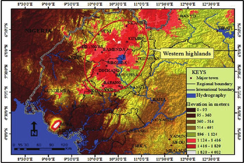
strengthened. Flood risk throne in the front row and 2.1. General presentation of the city of Bamenda
presents the annual occurrence record. In addition, it Bamenda is the head quarter of the Mezam division
affects all inhabited agro ecological zones of the planet in the Northwest Cameroon region. It is made of three
(Guha-Sapir et al., 2014). Human settlements with high subdivisions (Bamenda 1, 2 and 3) with 391 km² as
densities are the most vulnerable. In Africa, Nouaceur total area. This study concerns the urbanised part
et al. (2013) highlighted an increased flooding in some known as the city of Bamenda; that is about 12.49%
major cities in Mauritania and Burkina Faso. of this surface (4 880 hectares). The figure 1 shows the
In Cameroon there is an increase in the frequency of location of the city of Bamenda, between 5°56-6°00N
flooding in all agro-ecological zones (MINEPDED, and 10°08-10°12E. The population was about 496 931
2015). Bamenda located in the western highlands inhabitants in 2012 with 4.9% as annual growth rate.
of Cameroon presents a peculiar situation. With The city of Bamenda takes place at the heart of the
Abundant rainfall (> 2300mm/year), very hilly relief, western highlands of Cameroon. Its relief consists of
poor environmental conditions and very limited interspersed highlands with deep valleys. There are
control of urban development, this city is very exposed two topographic units separated by a scarp oriented
Figure 1: Location map of the area of study
59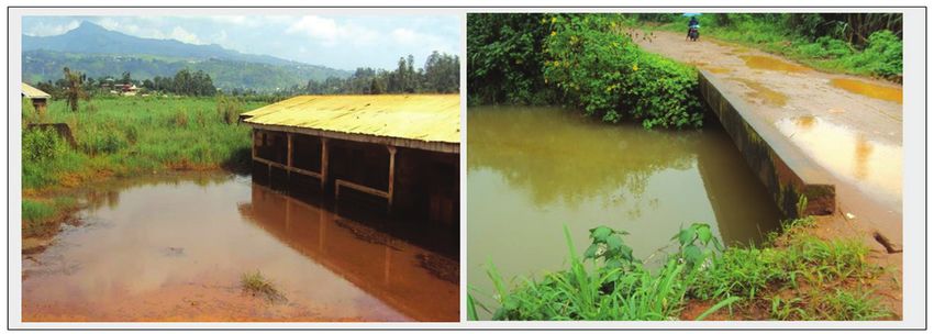
Saha F. et al. / Revue Scientifique et Technique Forêt et Environnement du Bassin du Congo. Volume 9. P. 58-68, Octobre 2017

NE-SW (Neba, 2011). Above the cliff, stands the upper                number of rainy days (1951-2010) was harvested in
plateau. It represents 10% of the total area of the city.            the regional delegation of the Ministry of Transport
Altitudes here vary between 1472m and 1573m. The                     for the Northwest. Administrative boundaries were
minimum altitude of the lower plateau is 1201m. This                 drawn from the forestry atlas of Cameroon edits by
part of town is home to nearly 90 % of urban facilities.             the National Institute of Cartography (NIC). An
The Mezam Division is part of the Niger catchment;                   ASTGTM image downloaded from https://lpdaac.
fueled in Cameroonian south part by the Mentchum                     usgs.gov/ was use to design topography and hydrology
River. One of its tributary is the Mezam River that                  features.
drains all runoff from the city of Bamenda.
                                                                     2.3 Analysis and interpretation
2.2. Data collection                                                 The data analysis was done separately. A data capture
After a literature review, field work was done in                    mask on SPSS enabled to analyse the answers to the
three stages. First, the design and implementation                   questionnaires. The same application was used in the
of a questionnaire to 172 target households in the                   construction of tables and figures. For rainfall data,
most exposed neighbourhoods and sensitive to flood                   many operations were carried out:
(Sisia, Mulang, Abangoh, New Layout, and Mougheb                      - The Hubert segmentation : it allows to observe the
Foncha Below). The questionnaire was used to collect                   nature of changes in the series of data (Hubert et al.,
information on the hazard from the population of the                   1989). With a significance level of the Scheffe test of
city; their perceptions and acceptance. In addition, the               1%, a major break occurred at the end of the 1950s.
questionnaire helps to assess the opinions of people                   This test was run through KhronoStat program
on the various adaptation strategies developed by both                 developed by IRD (Institut de Recherche pour le
city dwellers and local authorities. Semi-structured                   Développement).
surveys organized in the target neighbourhoods’
                                                                      - The Standardized Precipitation Index (SPI) : this
assembly points of view to reconstruct the history of
                                                                       statistic helps to differentiate dry years and wet
flood in the city of Bamenda. Monthly rainfall and
                                                                       years.

                  Figure 2: Location of the city of Bamenda in the high western lands of Cameroon
                          (Source: Image ASTERDEM and Interactive Forest Atlas of Cameroon 2011)

                                                                  60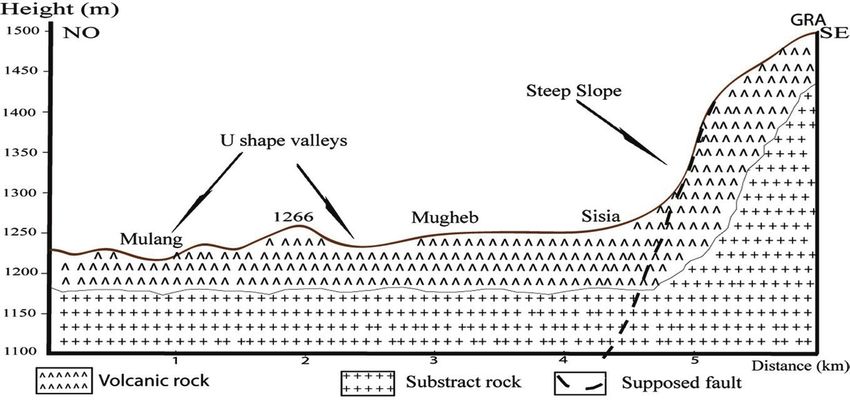
Saha F. et al. / Revue Scientifique et Technique Forêt et Environnement du Bassin du Congo. Volume 9. P. 58-68, Octobre 2017

                                                                     In this equation, “x” is the series of rainfall between
                      			                          Eq. 1             1995 and 2012 and “y” the series of numbers of
                                                                     victims (the dead) over the same period.
     x= annual rainfall, x̅ =mean and σ = standard
deviation.                                                           The mapping of flood risk in the city of Bamenda
                                                                     results from the application of the hydro
 - The calculation of the Coefficient of Variation
                                                                     geomorphology method (Ballais et al., 2011) by
  (CV): It is the ratio of standard deviation to the
                                                                     the superposition of several layers of information
  mean. It is expressed in %. This index is useful in
                                                                     including topography, hydrography and land use
  assessing the relative variability of a distribution.
                                                                     (Google Earth). The area marked in red (see figure
                                                                     7) is characterised by very gradual slopes (between
                      			                   Eq. 2                    0 and 2) and drained by a river with regular runoff.
- The correlation coefficient (r) ; it allows the                    The amber area is part of the major bed of rivers with
 identification of a correlation between two                         slopes less than 4°. The green area presents average
 quantitative variables. His equation is.                            slope that allows rapid circulation of surface water.
                                                                     The red area corresponds with spaces that cannot
                                                                     be built such as prescribed by the Town Planning
                                                                     Code of 2004 (Act No. 2004/003). The amber area is
                                         		               Eq. 3      subject to special arrangements and any construction
                                                                     must be regulated.
                                                                     3. Results
                                                                     3.1. General trends of rainfall: up between random
                                                                     variations and changes
                                                                     The data set (1951-2010) gives an overview of the
                                                                     rainfall behaviour in the city of Bamenda. Overall,
                                                                     the interannual average rainfall is 2354 mm. This is a
                                                                     relatively high (Tsalefac, 1983). The orography plays
                                                                     an important role in this situation (figure 2).
Figure 3: Standardized Precipitation Index (SPI)
                                                                    Figure 5: Structure of the annual number of days of
Table 1: Presentation of the rainfall decades from 1951             rainfall in the Bamenda city (1980-2010) change the
to 2010 series                                                      position of titles of figures

                                                                     Table 2: Perception of the floods by the population
                                                                                                             Number of
                                                                          Current state of flooding          favourable      Percent
                                                                                                              responses
                                                                       Less frequent and less violent        20             13.33
                                                                       Stable                                30             20%
                                                                       More frequent and more violent 100                   66.66%
Figure 4: Probability Graph procedure from Lee and Heghinian           Total                                 150            100%

                                                                  61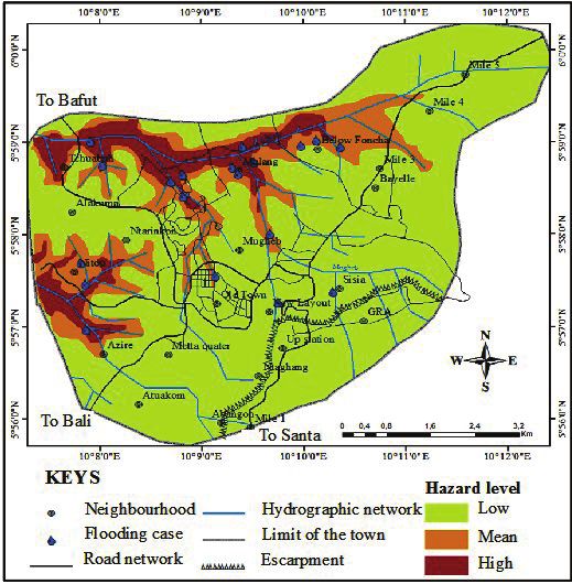
Saha F. et al. / Revue Scientifique et Technique Forêt et Environnement du Bassin du Congo. Volume 9. P. 58-68, Octobre 2017

Figure 6 : Examples of flooding in Bamenda city (A = Mulang has abandoned house, B = bridge Ntamulung incorrectly calibrated).

                                 Figure 7 : Bamenda topographical and geological cross section
Part of the fault line of Cameroon, high Western                     surplus years, including 2 years of extreme humidity
land is located at altitudes between 1,000 and 2,000                 (1954 and 1957) and 7 years of high humidity (2>
meters. Situated at 250 km from the coast, the city                  SPI> 1). In general, there is a concentration of exceeds
of Bamenda is located on the wind side of this                       in the early years of the series and severe droughts
highland. It experiences each year the arrival of a                  in 1990 and 2000; hence the general downward trend
humid wind (monsoon) which in its ascent causes                      of precipitation. Hubert segmentation defines two
enormous amounts of precipitation. Locally, there                    distinct portions with different trends in this data
are three large lakes in the area (Bamendjing, Nyos                  series with a shift in 1958. This break has a probability
and Awing) whose evaporation contributes to rainfall                 density of the order of 0.31 as shown in figure 4.
in the area. In addition, the presence of several forest             Prior to 1958, a constant high rainfall is observed
reserves (Ngemba Bafut, Bafi Ngemba, Nkom Wum,                       with an average of 2649 mm. After the break, the
Mbembe and Fungom) plays an important role in                        variability is more pronounced with an average rate
evapotranspiration and clouds formation. The analysis                of variation of 11.4%. Furthermore, the tendency is
of the series (1951-2010) allows highlighting a strong               upward of precipitation is felt since the early 1990s.
interannual variability around the mean (figure 3).                  Table 1 shows the characteristics of the six decades
Between 1951 and 2010, there are 31 deficit years. With              that make up this statistic series. The tendency to
years of extreme drought as in 1964, 1973 and 2003.                  higher amounts of rainfall for the last two decades
Counted among the driest years since 1871 (IPCC,                     and especially the strong interannual variations
2007) 2003 experienced a shortage of more than 19%                   may be related to the increase in SST (Sea Surface
of its rainfall in the city of Bamenda. There are 29                 Temperatures) in the Atlantic Ocean (Camberlin,

                                                                  62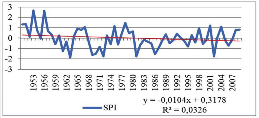
Saha F. et al. / Revue Scientifique et Technique Forêt et Environnement du Bassin du Congo. Volume 9. P. 58-68, Octobre 2017

                                      Figure 8: Flooding zoning in the Bamenda town
      (Credits: ASTERDEM Image, Interactive Forestry Atlas of Cameroon in 2011, Google Earth and field survey 2013)

                    Figure 9: Rainfall of the year 1999 compared to the normal average 1951-2010
                             (Source: data from Regional Delegation of Transport of the Northwest)
2007). In addition, the consumption of fuels, forestry               duration of submersion. The area is also facing
and agriculture activities are causing greenhouse                    constancy or even a slight decrease in the number of
gas emissions (CO2, CH4 and NO3) that contribute to                  rainy days (figure 5).
climate variability at the global scale.                             It rains on average 194 days each year in the city of
3.2. Impact of the rainfall variability on the hazard                Bamenda (53% of the year). This situation is typical
                                                                     of equatorial and humid tropical climates (Suchel
A Flood as a risk is the product of a hazard and a
                                                                     1987). Over the past two decades, increasing quantity
vulnerability. The flood that is to say, the upwelling
                                                                     of precipitation was not the result of an increase in
in the valleys is being strengthened and vulnerability
                                                                     the number of rainy days. Thus there is a higher
understood as sensitivity and exposure is increasing
                                                                     frequency of extreme rainfall (≥50 mm in 24 hours).
because of the forcing of climate and hydrological
                                                                     People testify more frequent and severe flooding in
world systems.
                                                                     quarters of the city of Bamenda (table 2).
3.2.1. Increasing the height of flood water                          It shows that over 66% of families surveyed denounce
The gradual increase in annual rainfall amounts                      not only increasingly frequent flooding but above all
especially on the last two decades is the cause of                   more and more violent. Violence refers to the power of
increased flood water heights. The surplus rainfall                  destruction. It is true that for this situation, population
enhances the speed of water runoff power and                         bring up nearly 10% the wrath of the gods of the

                                                                  63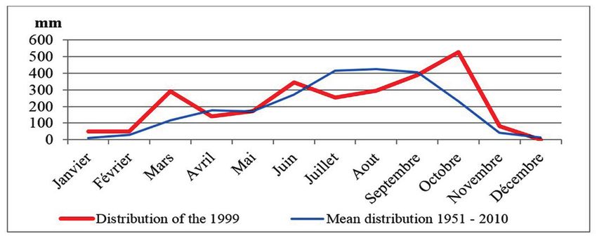
Saha F. et al. / Revue Scientifique et Technique Forêt et Environnement du Bassin du Congo. Volume 9. P. 58-68, Octobre 2017

Table 3: Summary of the sensitivity of floods to rainfall
   Climate         Sensitivity of the hazard
                                                                                Associated phenomena
  parameter       facing rainfall parameters
                 Enlargement of flooding            Invasion of more and more wide space by flooding water
                 area                               Accumulation of materials that obstruct ways of evacuation of water
                                                    Overflowing in stream beds and flooding in the lowlands
                 Increasing the height of the
                                                    Increase of rainfall water in the cleaning up network and surface run off
                 flood water
 Rainfall                                           Overflowing of protection tools (dykes and vegetal shield)
                 Instability in the rainfall
                                                     Upsurge of flash flood episodes
                 system
                 Decrease of annual number
                                                    Concentration of high rainfall period and upsurge of floods
                 of rainy days

Table 4: Vulnerability and sensitivity to rainfall variations in the city of Bamenda
   Climate         Vulnerability to rainfall
                                                    Associated phenomena
  parameter              variations
                                                    Endemic poverty
                 Impoverishment of the
                                                    Hunger
                 population
                                                    Multiple attacks on the health of population
                                                    More economic and human damage
                 Decrease in risk perception        Reduction of the resilience of affected population
 Rainfall
                                                    Reduction of risk acceptance
                 Complication                   of Weakening of existing infrastructures
                 development planning              Increase in investment costs
                 New requirements in risk
                                          Increasing costs for both proactive and operational management of risk
                 management

earth and witchcraft; but climate variability appears                the rapid collection of surface runoff. There are two
to have a significant share of responsibility alongside              types of valleys including the “V” and “U” shapes.
the urbanization poorly mastered (Nyambod, 2010).                    “U” shape valleys are prone flood areas.
Several situations observed on the field or related by               Between 1980 and 1990, the city of Bamenda
some respondents illustrate the increase of the height               experienced its greatest spatial expansion and
of flood waters: the abandoned homes, swamped                        densification (Nyambod 2011 and Saha 2013). This
bridges (figure 1).                                                  period corresponds to the driest decade as shown in
                                                                     the table 1 above. Thus some areas of stream beds
3.2.2. Enlargement of flood areas                                    were built because of the temporary dryness. The
Bamenda takes place at the heart of the western                      recovery in rainfall causes flooding in these areas
highlands of Cameroon. Its relief consists of plateau                after each significant rain (Old town, Mulang and
interspersed by deep valleys. This relief is divided into            Below Foncha). The hydro geomorphological method
two sets by a cliff oriented NE-SW over a distance of 6              (Ballais et al. 2011) by combining the topographical
km. Above the cliff, stands the upper plateau. The low               and hydrological factors allows the discrimination in
plateau is at the bottom. The topographic profile A-B                the city of Bamenda of three types of flood risk areas
(figure 6) summarizes the relief of the city of Bamenda              depending on the level of exposure to the hazard; as
into two main shapes: steep slopes and valleys. The                  presented in the figure 7.
steepest slopes of the escarpment are those located in               Roughly, the flood risk is prior to 30% of the city
the southeast of the city. The consequence of these                  of Bamenda, with 10% higher exposure and 20% of
steep slopes is their great capacity to collect water                average exposure. The risk area shows a widening
directly drained into valleys, where floods occur after              and episodes of extreme rains are causing flooding
heavy rainfalls. In addition, the bottom plateau has                 in low exposure areas. The damages caused by these
a few small peaks whose slopes are also involved in

                                                                  64
Saha F. et al. / Revue Scientifique et Technique Forêt et Environnement du Bassin du Congo. Volume 9. P. 58-68, Octobre 2017

types of floods are multiplied tenfold because of the                Table 5: Some flood historical records in Bamenda
element of surprise.                                                 (1995-2012)
3.2.3. Increased episodes of flash floods
Climate variability is also reflected in the instability
of seasons. While it was hitherto possible to predict
periods of heavy rainfalls, today it is more complex to
master the behaviour of different climatic parameters.
Analysis of monthly average data shown that the
period from July to August is at the heart of the rainy
season; but it is not uncommon to witness episodes of
extreme rainfalls out of this period. The distribution
of rainfall of the year 1999 illustrates this situation
(figure 8).
The year 2009 was a tri-modal system with peaks in
March, June and October. This may be the cause of
flooding outside the known period. This year was hit
by catastrophic flooding in Mulang neighbourhood
where one death was registered without forgetting
important material damages deplored in New layout
and Bayelle. The year 2000 was also a special system
with extremely abundant rainfall during the months of
August and September that totalized more than 1000
mm of precipitation. The result was more deadly,                     of the United Nations in 2000 when all nations of the
three deaths recorded. Table 3 provides a summary of                 world signed the “Millennium Declaration” in which
flood risk sensitivity to rainfall parameters.                       “the desire to create a globally favourable climate
3.3. Consequences of rainfall variability on                         for the development and the elimination of poverty”
vulnerability                                                        was contained in the Millennium Development Goals
Understood as the ability to maintain in front of a                  (MDGs).
hazard, the vulnerability of a given population is very              Today the world is facing climate changes effects,
sensitive to any phenomena that could impact not only                which seriously hamper the efforts of states in the
the environment but also on the economic and social                  process of eradicating poverty. In some countries of
conditions of the population. Climate variability                    the world such as Philippines, Nicaragua, Bangladesh,
has three major impacts on people’s vulnerability                    Benin, Ethiopia, etc. climate change makes almost
in the city of Bamenda namely the reduction of the                   impossible the implementation of strategies against
perception and acceptance of risk, complexity in                     poverty. Some communities are also experiencing
the development and management of risks by the                       significant regression following the disasters they face.
authorities and the impoverishment of population                     Note that the poorest populations of the world are the
already stricken by drastic economic conditions.                     most vulnerable to climate change (IPCC, 2014). This
Table 4 summarizes the impacts of rainfall variability               is due to their dependency vis-a-vis of nature and their
on the vulnerability of population.                                  very low ability to adapt because of their limited means.
                                                                     In Cameroon, 37.5% of the population lives below the
3.3.1. Impoverishment of the most vulnerable
                                                                     poverty line (NIS, 2014). This situation has remained
population
                                                                     steady since 2000. Today the government implements
Historically, the fight against poverty has always been
                                                                     a policy to reduce unemployment by creating jobs in
a major concern for humanity. With the emergence of
                                                                     both the public and private sectors. These government
the concept of sustainable development, improvement
                                                                     efforts are threatened by the effects of climate change
of living conditions through the eradication of
                                                                     (MINEPAT, 2009) affecting the country in several
poverty is one of the pillars. In Johannesburg in 2002,
                                                                     sectors. This is the case of agriculture, which is
during a World Summit on Sustainable Development
                                                                     experiencing a decline in yields in the sahelian part. In
(WSSD) all humankind reaffirmed its willingness
                                                                     2012, the country faced several floods that annihilated
to coordinate worldwide efforts to help the poorest
                                                                     the survival efforts of thousands of families in the Far
people to better their conditions. This commitment
                                                                     North, North, East and Northwest regions.
had already been the subject of a General Assembly

                                                                  65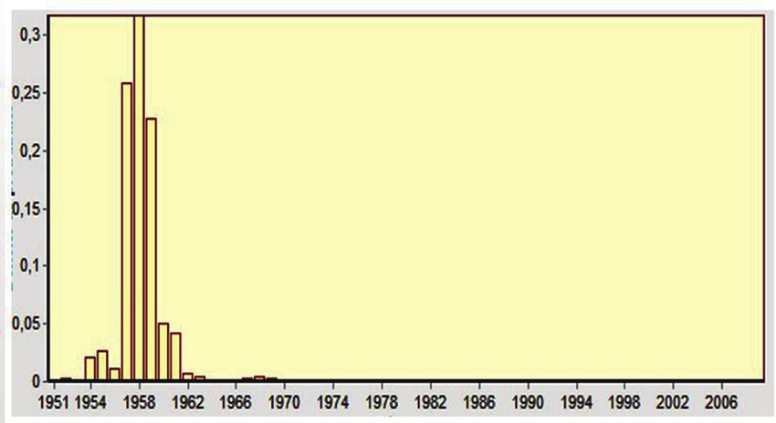
Saha F. et al. / Revue Scientifique et Technique Forêt et Environnement du Bassin du Congo. Volume 9. P. 58-68, Octobre 2017

In the city of Bamenda, as it is the case for other urban            Between 1995 and 2012, floods made about twenty
centres, poverty is endemic. The unemployment                        victims in the city of Bamenda and material damage
rate is increasing. The peri-urban agriculture is the                estimated at hundreds of millions of CFA francs. Most
main activity (MINHDU, 2011). This activity is                       proven years were 1998, 2000 and 2009. In addition it
defined by IFAD (International Fund for Agricultural                 should be noted that people generally avoid declaring
Development) as the most vulnerable activity to                      their losses because they are aware of their illegal
climate change especially when it is practiced                       occupation of risk areas.
in a rudimentary manner as in Cameroon. Thus,
the instability of the seasons, and the decrease in                  4. Discussion
the annual number of rainy days are factors that                     Many authors and organizations have looked at
threaten agriculture in the city of Bamenda and its                  climate changes in Africa. A split is emerging
surroundings. In addition, damages caused by the                     between observations made in the Sahelian tropical
floods are serious blows to survival efforts of urban                part and Equatorial Africa (AGRHIMET, 2011);
population.                                                          most pronounced disturbances affecting the dry
We can now count in the city of Bamenda homeless                     Sahelian region. In Equatorial Africa, rainfalls show a
families due to upwelling in their neighbourhoods. It                consistency in the interannual distribution. Variations
should also be noted that climate change will have                   are attenuated and poorly organized in space. This is
an impact on people’s health through the increase in                 due to a poor response of Central Africa to interannual
attacks linked to diarrheal and infectious diseases.                 variability modes including ENSO (El Nino Southern
                                                                     Oscillation) signal (Bigot et al., 1998 and Hulme,
3.3.2. Complication planning and risk management                     1992). The response to SST is also much minimised
by the authorities                                                   compared to West Africa. This quasi independence of
Arrangement of risky areas is complex. The different                 Central Africa to global changes can be explained by
urban management structures of the city of Bamenda                   the presence of the thick canopy that maintains high
namely: the sub divisional councils and the Bamenda                  humidity in the lower layers of the atmosphere.
city council have very limited means and facilities.                 In addition, the situation in the heart of the continent
Thus, an upsurge of risk arises new challenges                       on both sides of the equator decreases the sensitivity
which requires new management as much human                          to modulations of the atmospheric circulation on a
and material resources. For example it is now vital                  large scale (Camberlin, 2007). Interannual changes of
for every council to have a land use plan or local                   rainfall in the city of Bamenda are no exception to this
urbanization plan taking into account the variability                general trend. The break occurred in 1958 confirms
of climate parameters. This implies new skills and                   the independence of central equatorial Africa from
especially funding further research on the current                   the Sahelian zone where it is at the beginning of
state and future of people’s vulnerability to climate                1970s that a break occurred in the data of nearly
change.                                                              600 climate stations analysed by the AGRHYMET
3.3.3. Decreased perception and low risk                             Regional Centre in 2011. The random alternation of
acceptance                                                           surplus years and dry years is a general trend noticed
Already quite limited, risk perception by the population             throughout Africa for nearly two decades (Lebel and
of the city of Bamenda knows other hitches because                   Abdou, 2009 and AGRHYMET, 2011).
of climate variability. Firstly, concerning the risky                There is no doubt that climate risks in recent
period of the year, the instability of seasons decreases             years have experienced significant strengthening.
the ability of the population to forecast and even                   The frequency of droughts, storms and flooding
the build their protections. Spatially, higher annual                increasingly reinforced in the world is raised by the
rainfall induces flooding in areas, where people are                 IPCC as evidence of climate changes. Many West
not prepared. These realities have been impacting on                 African countries have experienced in the beginning
population adaptation efforts, especially the poorest                of 2010s the most catastrophic floods in their history
unable to cope with new threats. The decrease in                     (Badjana et al., 2014). The high interannual variability
perception is also the origin of the reduction in risk               of rainfall and erratic seasonal distribution noticed in
acceptance especially when authorities and rescue                    many central and West Africa increases the frequency
services do not provide substantial helps. Table                     of flash floods and extreme events (Mahe 2006 and
5 summarizes all floods registered in the city of                    Nouaceur et al. 2013). Although the correlation
Bamenda since 1995.                                                  coefficient between rainfall and the annual number

                                                                  66
Saha F. et al. / Revue Scientifique et Technique Forêt et Environnement du Bassin du Congo. Volume 9. P. 58-68, Octobre 2017

of flood victims in Bamenda is negative (- 0.0036),                  Badjana, H. M., Hounkpè, K., Wala, Kpérkouma,
the fact remains that climate variability affects both               Batawila, K., Akpagana, K. et Edjamé, K. S.
the hazard and the vulnerability of people exposed.                  (2014). Analyse de la variabilité temporelle et spatiale
A broader approach integrating material damage and                   des séries climatiques du nord du togo entre 1960 et
all victims (the dead and people affected) is required               2010. European Scientific Journal vol.10, No.11
to establish a complete correlation. A sectorial                     ISSN: 1857-7881
assessment of climate change effects presents                        Ballais, J. M., Chave, S., Dupont, N., Masson,
livelihoods of the poorest populations of the world as               E. and Penven, M. J. (2011). La méthode
very sensitive (IPCC, 2007). In Cameroon, agriculture,               Hydrogéomorphologique de détermination des zones
rearing, fishing, public works, urban development,                   inondables. physio-géo. Géographie physique et
forestry are among other the most affected sectors                   environnement. Collection ouvrages 172p.
(MINEPDED, 2015). This is why city dwellers as
                                                                     Bigot, S., Moron, S., Melice, J. L., Servat, E. et
the whole population become impoverished and city
                                                                     Paturel, J. E. (1998). Fluctuations pluviométriques
authorities are unable to answer their duties. It is
                                                                     et analyse fréquentielle de la pluviométrie en Afrique
absolutely necessary to pay more attention to climate
                                                                     Centrale. IAHS Publ. no. 252
changes in Cameroon because direct and indirect
implications are too much and no economic, social or                 Camberlin, P. (2007). L’Afrique Centrale dans
ecological sector is saved.                                          le contexte de la variabilité climatique tropicale
                                                                     interannuelle et intra saisonnière. Presses
5. Conclusion                                                        Universitaires d’Orléans. pp.25-39.
The main objective of this work was to study the                     D’Ercole, R., Pauline, Gluski, Hardy, S. et Alexis,
impact of rainfall variability on the risk of flooding               S. (2009). Vulnérabilités urbaines dans les pays du
in the city of Bamenda. From our analysis it is clear                Sud. Cybergeo European Journal of Geography.
that the annual rainfall is increasing over the last two             DOI: 10.4000.
decades. The number of annual rainy day is going                     Fonteh, M., Esteves, L. S. and Gehrels, W.R. (2009).
through a slight decrease. The distribution of rainfall              Mapping and evaluation of ecosystems and economic
over the year is also experiencing strong instabilities;             activities along the coast of Cameroon; implication of
increasing the unpredictability of the seasons. The                  future sea level rise. Coastline reports, 13:47-63).
consequence of these climatic changes can be noticed
                                                                     Guha-Sapir, D., Hoyois, P. and Below, R. (2013).
on the risk of flooding that is increasing in the city of
                                                                     Annual Disaster Statistical Review 2013 The numbers
Bamenda. At the level of hazard, there is an increase
                                                                     and trends. Centre for Research on the Epidemiology
of flood waters and their turbidity, unstable seasons
                                                                     of Disasters (CRED).
highlights the resurgence snap floods. The decrease in
the number of rainy days is the reason of the increase               Hubert, P., Carbonnel, J. P., Chaouche, A. (1989).
of episodes of extreme rainfall. The vulnerability of                Segmentation des séries hydrométéorologiques.
populations to flooding is also affected. We notice:                 Application à des séries de précipitations et de débits
a decrease of population adaptability, weakening                     de l’Afrique de l’Ouest. J. of Hydrology, 110, 349-
infrastructure, impoverishment of the population and                 367.
the decrease in risk perception. This study invites                  Hulme, M. (1992). Rainfall changes in Africa: 1931-
human communities to reassess their exposure and                     1960 to 1961-1990. Int. J. of Climato., 12, 685-699.
susceptibility to natural hazards; taking into account               INS. (2015). Présentation des premiers résultats de la
not only stationary factors but also climate parameters              quatrième enquête camerounaise auprès des ménages
marked in recent decades by important changes. The                   (ECAM 4) de 2014. Yaounde, Cameroun
definition of risk areas in cities and the regulation on
                                                                     IPCC. (2007). Bilan 2007 des changements
construction rules must consider climatic hazards
                                                                     climatiques. Contribution des Groupes de travail I,
increasingly strengthened.
                                                                     II et III au quatrième Rapport d’évaluation du GIEC
References                                                           114 p.
AGRHYMET. (2011). Le Sahel face aux changements                      IPCC. (2014). Changements climatiques 2014:
climatiques: Enjeux pour un développement durable.                   Rapport de synthèse (Résumé à l’intention des
Bulletin Mensuel Numéro spécial 43p                                  décideurs) www.developpement-durable.gouv.fr/giec
                                                                     40p.

                                                                  67
Saha F. et al. / Revue Scientifique et Technique Forêt et Environnement du Bassin du Congo. Volume 9. P. 58-68, Octobre 2017
Lebel, T., Abdou, A. (2009). Recent trends in the Faso). GeoSuds, UMR CNRS 6228 IDEES, Université
Central and Western Sahel rainfall regime (1990– de Rouen, France.
2007). Journal of Hydrology Nyambod, E. (2010). Environmental Consequences
Loi N°2004/003 du 21 Avril 2004. Régissant of Rapid Urbanisation: Bamenda City, Cameroon.
l’urbanisme au Cameroun. Journal of Environmental Protection. Vol. 1 No. 1,
Mahé, G. (2006). Variabilité pluie-débit en Afrique 2010, p. 15-23.
de l’Ouest et Centrale au 20ème siècle: changements PNUD/UNDP. (2008). UNDP Climate Change
hydro-climatiques, occupation du sol et modélisation Country Profiles. Cameroun. C.McSweeney,
hydrologique. HDR dissertation, Université des Saha, F. (2013). La vulnérabilité aux risques naturels
Sciences et Techniques Montpellier 2 en milieu urbain cas de la ville de Bamenda. Master II
MINEPAT. (2009). Document de Stratégie pour la thesis. The University of Yaoundé I. 150p.
Croissance et l’Emploi (DSCE) cadre de référence de Servat, E., Paturel, J.E., Lubes-Niel, H., Kouame,
l’action gouvernementale pour la période 2010-2020. B., Masson, J. M., Travaglio, M., Marieu, B.
Cameroun. 174pages (1999). De différents aspects de la variabilité de
MINEPDED. (2015). Plan National d’Adaptation la pluviométrie en Afrique de l’Ouest et Centrale.
aux Changements Climatiques. Document préparé Review of Water Sciences Vol. 12, No. 2, pp. 363-
avec le soutien du Japon, la GIZ, le GWP et le PNUD, 387.
154p. Suchel, J.B. (1987). Les climats du Cameroun. State
MINHDU. (2011). Master Plan of Bamenda City Thesis. Université de Bordeaux III. France, 1186
2011-2022. By Human Technology resources. pages.
Neba, K.C. (2011). Slope dynamics and flooding: a Sunday, S. K. & Ndi, R. A. (2012). The Hydro-
case study of the Mezam escarpment and its environs, geomorphological Implications of Urbanisation in
Mezam division, northwest region. Master II thesis. Bamenda, Cameroon. Canada. Journal of Sustainable
The University of Yaoundé I. Development.Vol. 5, No. 6; 2012.
Nouaceur, Z., and Gilles, S. (2013). Changements Tsalefac, M. (1983). Ambiance climatique des hautes
climatiques et inondations au sahel: Etude de cas de terres de l’Ouest du Cameroun. 3rd cycle thesis. The
Nouakchott (Mauritanie) et Ouagadougou (Burkina University of Yaounde 1.
68You can also read