Walking tracks & trails of the Western Bay - westernbay.govt.nz - New Zealand
←
→
Page content transcription
If your browser does not render page correctly, please read the page content below
Walking tracks
& trails of the
Western Bay
westernbay.govt.nz
Bowentown Domain

2
Walking tracks
& trails of the
Western Bay
With its diverse environment of coastline, hills,
wetlands, forest and grassland, the Western Bay
District has an abundance of outdoor experiences
on offer to walkers and trampers of all ages and
fitness levels.

The Department of Conservation (DOC) and Western
Bay of Plenty District Council have created some
fantastic tracks and trails that take explorers into
beautiful places and pose exciting challenges.

These walks consist of Council reserves and
parks, including many tracks managed by DOC.

Information on all DOC walks can be found
on their website: www.doc.govt.nz

Department of Conservation, 253 Chadwick Road,
Tauranga. Phone 07 578 7677.

Information on Western Bay of Plenty District Council
walks can be found on Council’s website:
www.westernbay.govt.nz
What to know
before you go
You must be well prepared when walking on
conservation land, especially on longer day walks.
Ensure you have strong, comfortable boots, a good
raincoat, warm clothing, a first aid kit, food and drink,
 a hat and sunscreen – and your mobile phone.

It is also advisable that you leave your tramping
intentions with a responsible person, in case you get lost.

Dogs
As an owner, it is your responsibility to keep your dog
under leash or voice command at all times. Please refer
to specific sites where dogs are not allowed at any time.

    Help protect our kauri forests
    Kauri dieback disease is threatening our kauri
    with extinction. It is spread by soil movement
    but you can help prevent it by:
    • Keeping to the tracks
       and off kauri tree roots
    • Cleaning your gear before
       and after visiting a kauri forest

4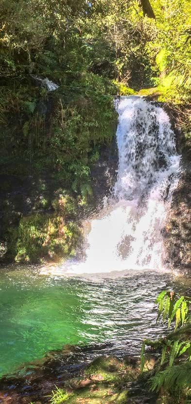
Track classifications
Walking times stated in this booklet and on park signs
are only an estimate; please allow extra time for slower
walkers or adverse weather conditions. Additional time
should also be allowed for sightseeing and rest stops.

          Short                         Walking
          walk                          track
Well formed track with         A defined, formed
easy grades. Constructed       track. Constructed to
to ‘shoe standard’.            ‘shoe standard’. Suitable
Suitable for people of all     for people of most ages
ages and abilities.            and abilities. Some tracks
                               may cross streams.

          Tramping                      Route
          track
Limited track formation,       Lightly cut marked
often with steep grades.       or unmarked tracks,
Constructed to ‘boot           often with steep
standard’. Suitable for        grades. Suitable for
fit, experienced and           fit, experienced and
adequately equipped            adequately equipped
people. River and              people with good
stream crossings may           backcountry
not be bridged.                navigation skills.

                                        Lock your
          Toilets                       vehicle
Public toilets available.      Please remember to lock
                               your vehicle and remove
                               any valuables.

                                     westernbay.govt.nz   5
1 2         Waihi Beach
                         Seaforth Road
Waihi
Beach                            4              3
Road
                               Athenree Road
                                      5           6
                                       Tuapiro
                                                            7                      Matakana Island
                                        Road

                                                     Kauri Point Road
                                                                11
                                                    10        Beach                                                      15
                                                                                             Tauranga Harbour
                                                     9        Road
                            Katikati                                                                     Omokoroa
                          Lindemann                                                                      Omokoroa
                          Road                                                                              Road
        8
                                                                  SH2
                     Uretara
                     Stream                  12         Hot Springs
                                                                                       Wright
                                                        Road
                                                                                       Road

                                                                     Aongatete            13          Whakamaramara
                                                                         River                                 Road

        Key to walks
        1     Waihi Beach’s Trig Walk & Water Reservoir Loop.................8
        2     Orokawa Scenic Reserve................................................................10
        3     Bowentown Domain........................................................................... 14
        4     Athenree Village................................................................................. 16
        5     Tanners Point.........................................................................................17
        6     Tuapiro Point........................................................................................ 18
        7     Kauri Point Historic Reserve........................................................20
        8     Lindemann Road................................................................................ 22
        9     Katikati Town Centre....................................................................... 24
        10    Uretara Stream Walkway................................................................ 26
        11    Beach Road Peninsular....................................................................27
        12    Tuahu Kauri Track.............................................................................. 28
        13    Aongatete Tracks...............................................................................30
        14   Leyland O’Brien Tramline.............................................................. 34
        15   Gerald Crapp Historic Reserve.................................................. 36
             & Omokoroa Peninsula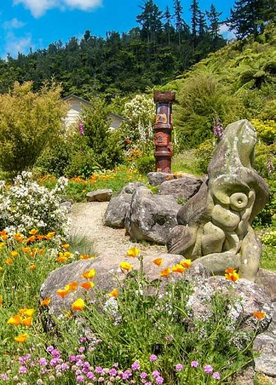
Bay of Plenty

                            Mount Maunganui
                                                                                                 SH2
                                                                                                               25

                                                                       Kaiate 22 Te Puke
                                                                        Falls
                  Tauranga                                             Road            27
                                                                Waitao        Te Puke
                                                                  Road 23     Quarry      No.3
                                                                               Road 24    Road
                                                             Welcome
                                                             Bay Road
                                                                              Manoeka
      17                                                                          Road
                                                                                                                          26
16     18 Te Puna                                                                                  No.4
                Wairoa                                                                             Road
                 River

                                                                                                             No.2 Road
                                                                                    Oropi
19                                                                                  Road
                                                      Pyes Pa                                                   28
14                             SH
                               29
                                                        Road
      Ngamuwahine
                                                                        SH
                                                                        26                       Mountain
      Road                                                                                        Road
                    21
                                                                                                              Mangatoi
                                                                                                              Road
     Ngamuwahine                                                                Omanawa
     River                    20                                                River
                                                                                                                     29

           16 Te Puna Quarry Park........................................................................40
           17 I’Anson Bush Reserve...................................................................... 42
           18 Minden Scenic Reserve..................................................................43
           19 Puketoki Scenic Reserve................................................................44
           20 Rapurapu Track................................................................................... 46
           21 Ngamuwahine .....................................................................................48
           22
              Papamoa Hills Cultural Heritage Regional Park.................. 49
           23 Te Rerekawau (Kaiate Falls).......................................................... 52
           24 Otawa Scenic Reserve.................................................................... 54
           25 Kaituna Wetland ................................................................................ 56
           26 Raparapahoe Stream........................................................................57
           27 Te Ara Kahikatea Pathway ............................................................ 58
           28 Ōtanewainuku ....................................................................................60
           29 TECT All Terrain Park ..................................................................... 64

                                                                              westernbay.govt.nz               7
1

Waihi Beach’s Trig Walk
& Water Reservoir Loop
Where: 61 Oceanview Road, Waihi Beach.

With excellent parking and a well formed track
this is a must-do during your visit to Waihi Beach.

Drive up Pacific Road, go left at the top, park the car
in the water reservoir car park. The start of the Water
Reservoir Loop is on the right of the reservoir. The Trig
Walk branches off the Loop track near the bridge.

    Water Reservoir Loop

        20 minutes

    The Loop walk goes around the old Waihi Beach
    reservoir. This track is mostly flat, with a few
    inclines. The Trig Walk branches off the Loop
    near the bridge.

    Trig Walk

        90 minutes

    The trail is 3 kilometres return and has some steps
    and steep bits. The majority of the walk is in the
    bush so this is suitable to do at any time of day.
    At the top you will enjoy a spectacular view of
    Waihi Beach, up the Coromandel coast and
    east across the Bay of Plenty.

8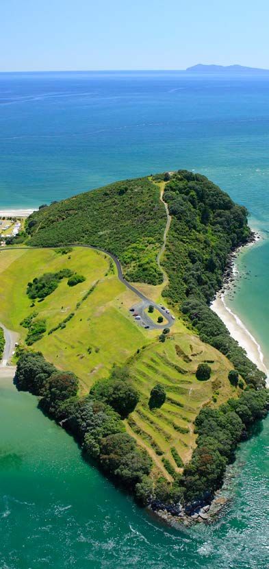
Waihi Beach Trig Walk

 Water Reservoir Loop

                Old Reservoir
                                Pacific Road

Trig Walk
                                      Beach
                                        Road
Homunga Bay

                          a   d
                       Ro
                  ta
               ga
            an
     a   tit
  Ng

                                      Homunga Bay Track

                                  William Wright
                                   Falls Track

William Wright Falls
                                                                   Orokawa Bay

                                         Orokawa Scenic
                                          Reserve Track

           Old Reservoir                  Pohutukawa
                                           Park track

                                                                   Waihi Beach
                                            Pacific Road
                                                           Bea
                                                           ch R
                                                             ado

               10
2
Orokawa Scenic Reserve
This spectacular coastal reserve embraces
panoramic ocean views, mature forest,
pohutukawa-fringed bays, good rock fishing
and picnic spots.
NO DOGS OR FIRES are permitted within this reserve
except on the Pohutukawa Park track (at the northern
end of Waihi Beach) where dogs on leash are allowed.
Orokawa Scenic Reserve Track
45 minutes: Waihi Beach – Orokawa Bay
This reserve consists of remnant coastal forest
and its coastline is fringed with pohutukawa.
The reserve has stunning views, picnic spots and
rock fishing. When the tide is right Orokawa Bay
is a perfect spot for a picnic, a surf or a swim.
William Wright Falls
90 minutes: Orokawa Bay – William Wright Falls
The bush track to the William Wright Falls is
accessible from the northern end of Orokawa
Beach. The journey up and along the stream bed
is best suited to the experienced hiker. Located
approximately 1.5 kilometres into the bush, the
falls are framed by a steep forested hillside and
they spill over a sheer rock face 30 metres above
the pool, dropping in two stages to the valley floor.
Continued overleaf...
westernbay.govt.nz 112 ...continued
Orokawa Scenic Reserve
Homunga Bay
90 minutes:
Orokawa Bay – Homunga Bay
30 minutes:
Ngatitangata Road end – Homunga Bay
Homunga Bay is notable for dense pohutukawa
forest, its beauty and its seclusion.
It can be reached by a track from the northern
end of Orokawa Bay. This track is well-developed
and maintained, providing spectacular views
and interesting terrain. Caution, good footwear,
water and a day pack are essential.
Another option for this walk is to start at
Ngatitangata Road (above Homunga Bay) and walk
down the hills to the coast, via Orokawa Bay
to exit at Waihi Beach.
If you decide to start and return at Ngatitangata
Road, be aware the path is a long, steep climb.
Walkers should allow three hours from
Waihi Beach to Homunga Bay, 90 minutes from
Orokawa Bay to Homunga Bay or 45-60 minutes
between Homunga Bay and Ngatitangata Road.
12Orokawa Bay
Orokawa Scenic Reserve
westernbay.govt.nz 133 Bowentown Domain Where: Northern end of Tauranga Harbour. Located on a rocky headland at the northern entrance to Tauranga Harbour, this 128 hectare reserve contains a number of pā sites dating back several hundred years. Anzac Bay offers safe swimming, picnic sites and toilets and there is camping at the Bowentown Holiday Park adjacent to the ocean beach. From the Te Ho pā site, which is easily reached, there are magnificent views of the harbour and the coast. To get here, follow the tracks from the motor camp or from the headland car park. From the car park you can drop steeply down to Cave Bay, a small beach at the harbour entrance, or you can walk to Te Kura a Maia pā site on the southern headland. From Anzac Bay a wide grassy track leads westward up to an area where several tracks meet. Straight ahead leads to Shelly Bay, a sheltered and safe swimming spot. Left takes you to a popular fishing area. Turning right leads to the summit. On the way up the summit track you pass a track which drops to the right leading down to the entrance of the Domain. Continuing on over the summit loop track, you are led down to the northern end of Shelley Bay. Stunning views of the upper harbour, Kaimai Ranges and the ocean coastline are your reward when you walk these tracks. This is a particularly spectacular place when the pohutukawa trees are flowering in December-January. Provision is made for freedom camping parking. 14
Anzac Bay to Shelly Beach

         Short loop: 30 minutes one way

  Headland car park to Te Ho pa site

         45 minutes round trip

  Anzac Bay-headland loop
  via Shelly Beach

         75 minutes round trip

Anzac Bay
                   Sea
                       fo
                      rth
                        Roa
                            d

                                                 Motor
                                                 Camp

Shelly
Bay                                                   Te Ho Pa

                            Anzac Bay
                                                    Cave Bay

                                          Te Kura a Maia
4
Athenree Village
Where: Northern end of Tauranga Harbour.
30 minutes one way
An easy stroll along the shores of Tauranga Harbour,
this walkway runs the length of Athenree Village.
It starts at the children’s playground on Waione Ave,
behind the boat ramp, and runs along a grassy foreshore
under large pohutukawa trees. There are views across
the harbour to the Bowentown headland. Views are
predominantly of the mudflats except at high tide.
Parking is available by the playground and on the grass
verge along Waione Ave. There are toilets across the
road from the playground.
The walkway is just over 1 kilometre and is almost level all
the way. There are no steps or steeper climbs. Total time
for both directions is about 30 minutes. It’s possible to
return to the start of the track from the Dr North Memorial
Reserve via Pohutukawa Drive and Athenree Road.
Pohutukawa Drive
Estuary
Ro
ret
an
aD
riv
e
At
he
nre
eR
oa
d
16 Waione Ave5
Tanners Point
Where: Off Tanners Point Road, north of Katikati.
30 minutes return
A most enjoyable outing, this short walk leads
you through a picturesque harbourside reserve.
The setting, plus picnic tables and toilets, makes
it ideal for quiet family outings.
Start your walk at the beach near the jetty, continue
along the pohutukawa-fringed track that follows the
harbour’s edge around to Moana Drive, then down to
a sandy beach.
Return the same route or via Moana Drive.
Beach
e
D riv
na
a
Mo
Giles Way
ad
Jey
Point Ro
Tanners Point Reserve
Tanners
Boat ramp6
Tuapiro Point
Where: Off Tuapiro Point Road, north of Katikati.
30 minutes return
Tuapiro Point is a small sandspit across the channel
from Tanners Point.
A track takes you onto the esplanade reserve and runs
along the spit to a fence. When you get to the fence,
step on to the beach and continue to the end of the
sandspit for some great views of the inner harbour.
At certain times of the year, a lot of seabirds gather
here. Please take care not to disturb them, or any other
estuary wildlife.
Retrace your steps or take a short detour and explore
the grove of landmark pine trees on your return journey.
Tra
ck
d
Roa
piro
TuaTuapiro Point
Horse riding on the Beach at Tuapiro Point
Tuapiro Point
westernbay.govt.nz 19Looking south from Tuapiro Point towards Ongare Point and Kauri Point. 20
To Ongare Point

                                                            Pa Site

                     Chelmsford Street

             t Roa
                     d                     Esplanade Road
                                                                   Pa Site
     i   Poin
Kaur
                Road
                stops                    Kyber Pass
                here
                                                            Jey

     7

 Kauri Point Historic Reserve
 Where: Off Kauri Point Road, north of Katikati

                80 minutes return

 Three features in particular attract people to this reserve:

 •T
   he magnificent specimens of pohutukawa
  lining the shore
 •A
   long, wooden jetty that extends 200 metres
  out into the harbour (highly popular for fishing)
 •S
   everal pā fortification sites.

 To get to this reserve go to the end of Kauri Point
 Road and turn right. From here the route is along the
 paddocks between the fenceline and Esplanade Road.

 After dropping down it links up with the northern
 end of Chelmsford Street. Here you have the choice
 of turning back to the carpark via Chelmsford Street,
 or continuing down and along near the shore to the end
 of Ongare Point Road.

 Please take care walking around the cliff edges
 and please follow instruction signs.

                                                                             westernbay.govt.nz   21
8
Lindemann Road
Where: Turn left off SH2 1 kilometre north
of Katikati
Ridge Track Kauri Dams
3 hours return
STOP KAURI DIEBACK DISEASE SPREADING
Keep to the tracks and off kauri tree roots.
Clean your gear before and after visiting a kauri forest.
NO DOGS OR FIRES allowed in the park without a permit.
To reach the start of the tracks to the Kaimai Mamaku
Conservation Park go through the gate and 100m west
across the saddle – once the site of a Māori pā. Signs
indicate the start of two tracks – Ridge Track to the
left and Pack Track straight ahead.
IGNORE the farm track to the right.
The Ridge Track enters the bush and climbs steeply
to the ridge westwards. The grade eases as the track
climbs and further on the track descends into the
upper Wairoa Stream catchment.
About 75 minutes from the road the track passes
an old Kauri dam. Continuing westward about
10 minutes is a junction.
To the right is the Lindemann Road Pack Track which
leads back to the road past the site of the old cookhouse
of a logging camp, via the longer northern route.
22Pack Track
5 hours return
Follow the Pack Track sign (take care not to confuse
it with the farm track on your right). The Pack Track
follows an easy upward grade, winding its way through
bush gullies and emerging through scrub to overlook
the Wairoa Valley and the distant Ananui Falls.
About 75 minutes from the road the track branches –
to the right it leads down to Wairoa Valley. Continue to
follow the Pack Track to the upper Wairoa Kauri dams.
The return to Lindemann Road via the Pack Track will
take about as long as the upward journey. Returning
via the Ridge Track is considerably shorter but much
steeper down the ridge.
NOTE: The Cashmore Clearing
Track, accessed from these
tracks is currently CLOSED
to protect from the spread
of Kauri Dieback Disease.
Pack Track
Ridge Track
Lindemann Road
westernbay.govt.nz 239
Katikati Town Centre
Where: Starts at Beach Road in Katikati.
4o+ minutes return
For those who appreciate art in the landscape this
is more of an experience than a brisk walk.
The journey starts at the car park in Haiku Park
reached via an access road on the northern side
of Robert Harris cafe. There is ample scope to wander
various pathways and appreciate the haiku verse
carved into the boulders and pavement.
The Uretara Stream runs through the park.
The main path leads over a footbridge, and
downstream to the highway and Uretara Landing.
From the landing, stroll up the main street to appreciate
the murals and other works of art throughout the town
centre. Rest at a cafe, or at the replica kauri dam water
feature in Diggleman Park, before crossing the road
and returning to your vehicle.
Cyclists and walkers can now cross the Uretara Stream
via the new 45 metres long single-span suspension
bridge, which follows where the old railway line used to
go, connecting to the footpath along the stop-bank on
Uretara Drive.
The new bridge complements the growing network
of cycle trails around Katikati, providing a ‘loop’ around
the stream, and giving residents of Highfields Drive
pedestrian access to the southern end of town.
24Highfi
elds Drive
Uret
ra D a
Uretara Drive
rive
To Waihi
Birch Lane
Kaimai La
ne
To Tauranga
Uretara Stream
SH2
SH2
Park
Ma
in Roa
d , Ka
tika
Diggleman
ti
Road
Road
Beach
Beach10
Uretara Stream Walkway
Where: Starts at Beach Road in Katikati
or accessed off Levley Lane.
45 minutes one way
This walk follows the Uretara River to the harbour
edge, starting at Beach Road at the site of the Uretara
Landing which played a key role for early settlers.
The walkway meanders downstream along the
esplanade reserve, past farmland, private gardens and
estuary wetlands – ending at the Park Road Reserve.
The return trip can be the same way or via
residential streets.
Harbour
d a
ea a
Ro
Str etar
m
rk
Pa
Ur
SH2
Beach
Katikati Road11
Beach Road Peninsular
Where: Starts at Beach Road, Katikati,
or from Pukakura Road.
About 60 minutes one way
Dogs allowed but must be on leash to protect bird life.
This is a delightful, scenic, easy-going walk around
the harbour edge.
The track is four kilometres long and is all-weather,
non-tidal and the footing is recycled concrete.
Bird life is plentiful and there are lovely views across
to Matakana Island and to Tutaetaka Island which
is a sacred Māori burial (urupā) place.
ad
kura Ro
Puka
o ad
ch R
Bea
westernbay.govt.nz 27Tuahu Kauri Track
Hot Springs Road
Tuahu Kauri Track
Tuahu Kauri
2812
Tuahu Kauri Track
Where: Off Hot Springs Road, south of Katikati.
50 minutes return
STOP KAURI DIEBACK DISEASE SPREADING
Keep to the tracks and off kauri tree roots.
Clean your gear before and after visiting a kauri forest.
NO DOGS OR FIRES allowed in the park without a permit.
A magnificent kauri tree is a stunning feature of
this walk. The kauri is known as Tuahu, named after
its location on an old Māori route that was used as
a bridle path in the 1890s.
A well-benched and graded track winds through native
forest of young kauri ‘rickers’ and juvenile rimu trees.
After 20 minutes, a side track leads to a platform
surrounding one of the largest kauri trees in the
Bay of Plenty. Beyond this, the main track narrows
and becomes more difficult, continuing to the crest
of the Kaimai Range. Return by the same route.
Adventurous walkers may choose to explore
more challenging tracks in the Kaimai Mamaku
Conservation Park.
For more information on these walks visit
the Department of Conservation website:
www.doc.govt.nz/Documents/parks-and-recreation/
tracks-and-walks/bay-of-plenty/
kaimai-to-coast-brochure.pdf
westernbay.govt.nz 29Aongatete 30
13

Aongatete walks
Where: Walking tracks start at the carpark, on a short
access road near the end of Wright Road south of Katikati.
Towards the Aongatete Outdoor Education Centre there
is a parking area on the access road and a toilet nearby.

  NO DOGS OR FIRES allowed in the park without a permit.

Located in the Kaimai Mamaku Conservation Park
the walks at Aongatete take you through puriri and
kohekohe forest along the Aongatete Stream.

One of the tracks provides access to the North South
Track which runs along almost the whole length of the
Kaimai Range. The other tracks provide walks through
regenerating native forest and access to a popular
swimming hole in a local stream.

Although there are no viewing points along the tracks
they all provide a pleasant walk through the forest,
with forest canopy covering almost the entire
length of the tracks.

There are four tracks starting near the education centre,
providing options from a very short nature walk to a
longer loop walk. A 400 metre access track leads
from the carpark to the junction of the four tracks.

  Nature Trail

      15 minutes return

  Nature Trail is a loop starting and ending
  near the education centre.

                                     Continued overleaf...

                                     westernbay.govt.nz    31
13 ...continued
Aongatete walks
The Aongatete Short Loop Track
1 hour return
This track shares the northern part of the
Long Loop Track, with a connecting track
between the two long loop tracks.
The Aongatete Long Loop Track
3.5 hours return
This track runs mainly in a north-south orientation,
with an eastern leg and a western leg. The eastern
leg mainly has a gentle gradient with long straight
stretches. It may once have been a tramline track.
The western leg runs through more uneven terrain
and includes three stream crossings. Even on a
winter’s day after two days with rain these streams
could be crossed without getting wet feet.
Aongatete Link Track
1 hour to North South Track
The Aongatete Link Track continues to the North
South Track. On the way there is a branch leading
to a popular swimming hole. The walk to the
swimming hole is marked as a 30 minute walk
each way from the Link Track.
32Wright Road
Aongatete Link Track
Nature
Trail
Lodge
Swimming
Hole
Short Loop
Aongatete
River
Long Loop
westernbay.govt.nz 33leyland O’Brien Tramline 34
14

Leyland O’Brien Tramline
Where: Leyland O’Brien Tramline Track is in the south
of the Kaimai Mamaku Forest Park. It starts at the end
of Whakamarama Road, north of Tauranga, off SH2,
via Barrett Road.

  Leyland O’Brien Tramline Track

       2 hours one way

  Either return the same way back to Whakamarama
  Road or follow the North South Track to the
  north and take the Ngamarama Track back to
  Whakamarama Road (this is a longer road trip).

From the Whakamarama Road end, the track descends
for 100m to the junction of the Leyland O’Brien
Tramline and Ngamarama Tracks.

Take the left track, which follows the old tramline beside
the headwaters of the Ngamuwahine River. This section
is flat. After about 90 minutes the river is crossed and
the tramline climbs slightly to the junction with the
Ngamuwahine track. (It is 90 minutes to Ngamuwahine
Road from here).

Leyland O’Brien Tramline Track continues southwest
for a further 30 minutes to meet up with the
North-South Track.

                                     westernbay.govt.nz   35
Gerald Crapp Reserve 36
15

Gerald Crapp Historic
Reserve and Omokoroa
Peninsula
Where: Turn right off SH2 at Omokoroa, 14 kilometres north
of Tauranga. Drive along Omokoroa Road to Myrtle
Drive and the reserve is at the end of Gellibrand Place.

  Please refer to on-site signage for prohibited
  and restricted areas for dogs.

There are a number of walks on the peninsula –
the most popular being a 40-minute walk around
the tip that includes the Gerald Crapp Reserve.

In 1975, Gerald Crapp of Omokoroa gifted the reserve
to the nation. Gerald was born on the property and
lived at Omokoroa Beach all his life. The reserve has
important associations with his family (Tice Gellibrand)
and the European settlement of the District as well
as with pre-European occupation of the area.

This reserve covers about two hectares and has lovely
views across to Matakana Island and over the Tauranga
Harbour. The many trees were planted by Joseph Tice
Gellibrand one of the early Crapp family settlers who
brought the seedlings from Tasmania, including Moreton
Bay figs, London Plane and Holm Oak. A Eucalyptus
botryoides (Southern Mahogony) was felled in 2011
due to rot and its stump carved into the likeness of
Rev Joseph Tice Gellibrand.

The Wai-Huri Pa is on the headland within the reserve.
This is an important archaeological site and its deep
trench can still be seen.

                                      Continued overleaf...

                                      westernbay.govt.nz   37
15 ...continued
Gerald Crapp Historic
Reserve and Omokoroa
Peninsula
Domain to Bramley Drive
30 minutes each way via Historic Reserve
A longer walk of about 9 kilometres continues
from Bramley Drive and along Hamurana Road
to a coastal walk alongside the Omokoroa Golf
Course. It crosses the peninsula to the Cooney
Reserve and heads back along the waterfront
to the Domain. The coastal walk alongside the
golf course is not passable at high tide, but there
is an alternative track along the northern and
eastern side of the golf course.
This walk is tidal.
Appropriate footwear is recommended.
Parking is available near the Domain on The Esplanade,
or on the Domain off of Harbour View Road, as well as
at several other locations with access to the walk.
Toilets are available in the Domain and by the
sports grounds on Western Avenue.
38Gerald Crapp
Historic Reserve
Omokoroa
Domain
Je
y
e
d
na
spla
The E
Omo
koroa
Road
oroa
Road
ad
Hamurana Ro
Omok
Ti
nop
ai
Drive
Dr
ive
Margaret
Anderley Avenue
ad
Golf Course
Omokoroa Ro
Western
Avenue
ace
r
Ter
de
esi
Lak
Kayele
ne Pla
ce
Lynley Park DriveTe Puna Quarry Park
Main Track
Amphitheatre
Picnic Picnic
Te Puna
Quarry Park Road
4016
Te Puna Quarry Park
Where: Take the Te Puna Quarry Road turn-off
(signposted), west of Te Puna, left turn off SH2.
Main Loop Track
45-60 minutes return
The Quarry Park has become a destination in the
Western Bay for locals and visitors. Covering about
32 hectares, it has many walking tracks – take your
pick through waterways, native and exotic gardens,
garden art features and picnic areas.
From the higher climbs are stunning views from
the Coromandel ranges to the eastern Bay of Plenty.
Featured throughout the park are sculptures by
local artists.
Walking tracks are easy for the moderately fit and this is a
place to enjoy nature, peace, stunning views and great art.
The park is a quarry that was in operation from
1911 to 1970. Transforming it into a The Quarry Park
and wilderness garden was a dream of local resident
Shirley Sparks who used to look out at the scarred
rock faces of the neglected quarry from her kitchen
window in Munro Road.
On Shirley’s inspiration, backed by a team
of enthusiastic locals, the Te Puna Quarry Park
Society was formed in 1993 and the park was
granted reserve status in 1996. It was opened
by the Governor General Sir Michael Hardie Boys
in 2000 and has since become a world class park
that is a visitor destination and a mecca for artists
of all mediums to add their inspiration to the Park.
westernbay.govt.nz 4117
I’Anson Bush Reserve
Where: Loop Road, turn right off SH2
just north of Te Puna.
I’Anson Bush Tracks
Up to 45 minutes return
This reserve was gifted to the Queen Elizabeth II Trust
(QEII National Trust) in 1987 by local residents Keith
and Takiko I’Anson.
This quiet picnic spot has been turned from pasture
to native bush, with a small lake – Lake Taki – formed
by damming the Waikaraka Stream. From the carpark,
tracks circle the lake and pass through a grove of native
trees. The track goes downstream to Armstrong Road
and returns on the same route.
To Omokoroa
Loop Road
To Tauranga
ad
Ro
SH2
ngo
mstr
Ar18
Minden Scenic Reserve
Where: Ainsworth Road, left off SH2
just north of Te Puna.
Minden Scenic Reserve Loop
15 minutes return
This is a very popular short and sweet walk.
A pond featuring waterfowl is below the entrance
to the reserve.
The walk follows a broad grassy avenue for 300 metres
before entering a bush track that travels alongside
a stream through regenerating forest dominated by
rewarewa and manuka trees.
After about 10 minutes, the track crosses a small bridge
and doubles back downstream to a pleasant open
picnic area. A little further on, the track swings hard
right down to a bridge and then climbs to rejoin the
route at the grass avenue. There is an unmarked track
continuing uphill from the turning point of the loop walk
and ending on Minden Road near the intersection with
Dawn View Place. The unmarked track up the
hill gets used by walkers and by mountain bikers.
Gate
d
oa
hR
ort
sw
AinPutetoki Reserve
Leyland Road
Whakamarama Road19
Puketoki Reserve
Where: Leyland Road, Whakamarama.
Turn left off SH2 at Barrett Road and follow the signs.
Puketoki Reserve Bush Tracks
Short loop: 20 minutes. Long loop: 1 hour
This bush reserve (34 hectares) was donated
to the Whakamarama Community in 1926
by Henry Sharplin of the Whakamarama
Land and Timber Company.
Before that time it was milled, so only the old surviving
trees would be those not suitable for timber at that
time. Tramways for transporting logs can still be
seen along the walking tracks.
Puketoki is one of the oldest reserves in the Western
Bay of Plenty and the Te Puna Stream, which runs past
the picnic spot, provides a safe, shallow spot to cool off.
There are two loop tracks, a short loop and a long loop.
Most of the short loop is shared with the long loop
nearest to the reserve entrance. Both loops together
are about 3.2 kilometres in length and can be walked
in about one hour. They are also popular fitness tracks
for runners.
The short loop is an easy walk with gentle slopes and
no steps. The long loop has steps in various locations,
but no steep bits. Both are well marked and well formed.
Car parking, picnic area and toilets at entrance.
Dogs on a leash are permitted in the reserve.
westernbay.govt.nz 4520
Rapurapu Track
Where: On SH29, about 4 kilometres past the Kaimai
Range Summit towards the Waikato side, a short gravel
road on the left (not signposted) leads to a parking area
where the track begins.
Rapurapu Track
1 hour 15 minutes over 5 kilometres
return via same track
Caution – multiple river crossings are required.
These are not difficult during good weather but may
become impassable after heavy rain.
STOP KAURI DIEBACK DISEASE SPREADING
Keep to the tracks and off kauri tree roots.
Clean your gear before and after visiting a kauri forest.
NO DOGS OR FIRES allowed in the park without a permit.
This walking track is a beautiful cool retreat during
the summer months.
The track features a mature tawa/podocarp forest
with many fern species in the understorey, a stream
with swimming holes and three impressive kauri trees
that are growing near their southern limit.
The track passes through pine forest before entering
bush and continues on an easy grade for 20 minutes
before descending to the Rapurapu Stream, which
it crosses eight times before reaching the kauri grove.
The largest tree measures 180 cm in diameter and 14m
to the first branch.
46There’s a view of the three big trees from the rocks
in the middle of the stream, just before climbing the
boardwalk steps. Kauri have a shallow root system
which can easily be damaged. Please keep to the
boardwalk to avoid trampling the sensitive roots.
This area is an ecological reserve within the Kaimai
Mamaku Conservation Park.
SH
29
To Kaimai Range summit & Tauranga
Rapurapu Stream
Rapurapu
Ecological
Area
Kauri Trees21
Ngamuwahine Track
Where: Ngamuwahine Road. Off SH29, on left about
9 kilometres on the Tauranga side of the Kaimai Range
summit. Follow road to Ngamuwahine Lodge.
Ngamuwahine Track
90 minutes one way
This track climbs up through the bush and crosses a
river behind the lodge at the end of Ngamuwahine
Road, before levelling out on a ridge. The track
finishes at an intersection with the Leyland O’Brien
Tramline Track. Return the same way.
The track starts at the end of the road, past
the lodge and into the forest.
To get to the actual track, you have to climb
over the locked gate which is located to the right
of Ngamuwahine Lodge. Follow this track and you
will get to the actual start of the Department of
Conservation track. This track leads from the end
of Ngamuwahine Road and takes you to a junction
with the Leyland O’Brien Tramline Track.
Leyland O’Brien Tramway Track
To Whakamarama Road
Ngamuwahine River
To Tauranga
48 Ngamuwahine Road SH
2922
Papamoa Hills Cultural
Heritage Regional Park
- Te Rae o Papamoa
Where: Poplar Lane, off SH2, 17 kilometres south
of Tauranga. Starts at car park.
NO DOGS OR BIKES allowed in the park without a permit.
This park is significant in New Zealand’s archaeological
landscape as it is the most complex Māori pā site
in New Zealand.
As such it is a unique example of historical occupation
in a relatively small area. This can be attributed
to careful management by the McNaughton family
since the late 1800s.
The McNaughton family began farming the property
around 100 years ago and supported the establishment
of Papamoa Hills Regional Park. The park was
established in 2003 and is jointly owned by Bay
of Plenty Regional Council, Tauranga City Council
and Western Bay of Plenty District Council.
Te Rae o Papamoa has witnessed waves of immigration,
from the earliest ancestral waka through to Captain
James Cook and the Pakeha who followed him.
The area has also witnessed much conflict as control
of Te Rae o Papamoa and the surrounding plains was
contested between successive waves of occupants.
Continued overleaf...
westernbay.govt.nz 4922 ...continued
Walking the hills
60 minutes return
The main walking track is from the carpark on
Poplar Lane to the trig station (at 224m). This track
rises fairly steeply and leads through native bush
and open farmland. The main track showcases the
terracing on several pā sites. The reward at the
summit is a spectacular panoramic coastal view.
There are several other tracks which allow you
to explore the cultural heritage of the park and
make the most of the expansive views. Most
tracks lead you to each of the six pā sites within
the park boundary.
Although most tracks are well formed, good walking
shoes are recommended, as is a reasonable level
of fitness. Take a bottle of water with you as there
is no drinking water supply in the park.
There is an information board in the car park that
provides further information about using the park.
The park is also an operational farm. Remember
to always leave gates the way you found them.
Open hours: 6.30am - 7pm (winter); 6.30am - 9pm
(summer). The gate to the carpark is locked overnight.
50To Tauranga
Pā Site
Pā Site
Karangaumu
Pā Site
Pā Site
Patangata
Pā Site
Summit SH2
e
Lan
lar
Pop
To Te Puke
Papamoa Hills Cultural Heritage Regional Park
- Te Rae o Papamoa
westernbay.govt.nz 51Lower Kaiate Falls
Lower
Falls
Upper Falls
Ka Ka
i at iat
e
Fa e
l St
ls
Ro re
a am
d
5223
Te Rerekawau (Kaiate Falls)
Where: Off Kaiate Falls Road
Te Rerekawau (Kaiate Falls)
60 minutes return
In a pretty, bush-filled ravine where the Kaiate Stream
drops over ignimbrite bluffs, a series of cascades and
waterfalls combine to create Te Rerekawau Falls.
They are sign-posted from Welcome Bay Road
as “Kaiate Falls”.
Drive up Waitao Road and after about 4.9 kilometres
turn left at Kaiate Falls Road. The scenic reserve
containing the falls is a further 1 kilometre and
a vehicle track leads to the car park.
Above the car park there is a picnic area, with
tables and toilet, offering good veiws towards
Mount Maunganui and the Port of Tauranga.
The walking tracks are well formed, although quite
steep in some places. The main track leads to the top,
and then to the base of the upper series of falls before
continuing downhill to the lower falls. Another track,
just below the car park, follows the stream back to
the road bridge. Track junctions are well sign-posted.
Please take note of all signage about water quality
and safety.
westernbay.govt.nz 5324
Otawa Scenic Reserve
Where: A well defined track starts at the end of
Manoeka Road, off SH2 between Te Puke and Papamoa.
There is a picnic area and sealed car park
at the end of Manoeka Road.
A detailed map of the tracks in Otawa Scenic Reserve can
be found on the Department of Conservation website:
www.doc.govt.nz/parks-and-recreation/places-to-go/
bay-of-plenty/places/otawa-scenic-reserve/
Manoeka Road to reservoir
15 minutes one way
A track leads to a small clearing beside Te Puke’s
original water source. The track crosses a stream
before entering the reserve. It continues through
a pūriri grove to a small clearing beside Te Puke’s
original water reservoir.
Return via the same track
Manoeka Road to Otawa Trig
1 hour 45 minutes one way
Take a left hand turn below the reservoir to join
with the Otawa Trig Track
54Te Puke Quarry Road to Otawa Trig
4 hours return to Te Puke Quarry Road
A longer half-day walk starts from the top of
Te Puke Quarry Road. This walk crosses private
farm land to the reserve where the track leads
to the Wharetetarakeho Trig and follows the gently
undulating ridgeline to Otawa Trig. Visitors can
retrace their steps or continue along the track,
which then descends steeply to meet the Otawa
Reservoir Track.
400 metres past the Otawa Trig, a branch to the right
leads to Otanewainuku. This track crosses private
land and is not regularly maintained by DOC.
NO DOGS OR FIRES allowed in the park without a permit.
Te Puke
Wharetetarakeho Quarry Road
Manoeka Road
Otawa
Dam
To Otanewainuku westernbay.govt.nz 5525
Kaituna Wetland
Where: Turn off SH2 onto Maketu Road. Turn left onto
Te Tumu Road. At the end of the road, turn left again
onto Kaituna Road. At the northern end of Kaituna
Road, turn right over the bridge onto Pah Road
– the carpark is immediately to the right.
Main Loop Track*
1 hour 15 minutes return
NO DOGS allowed.
The walk meanders through the wetland for just
over 6 kilometres.
Signage at the carpark has information about the
Lower Kaituna Wildlife Management Reserve.
The wetland has an abundant supply of waterfowl.
Two loop tracks and a viewing hide have been built
to get close up and personal with the wetland.
Note: Hunters occupy the area for the hunting season,
from the first weekend in May until the end of June.
*Check with DOC before venturing out on this trip
to ensure it is open: www.doc.govt.nz
SH2
Kaitun
a RoadNo.4
Roa
d
Raparapahoe
Stream
Waterfall
26
Raparapahoe Stream
Where: 7 kilometres from Te Puke, off No 4 Road.
Raparapahoe Stream
60 minutes return
This trail takes you down to the picturesque
Raparapahoe Stream, running through a narrow,
densely-bushed gorge.
The descent from the road and the climb back up are
very steep in places, so only those who are fit and agile
should attempt this walk. To get to the starting point,
drive up No. 3 Road and turn into No. 4 Road. Cross the
bridge, turn immediately left and drive for 2.4 kilometres
where there is a sign-posted roadside parking bay.
The track drops steeply through mature tawa forest.
When it reaches the bottom of the gorge it continues
upstream to a large pool at the base of a three metre
waterfall - perfect for a refreshing dip before tackling
the climb back up to the road.27
Te Ara Kahikatea Pathway
Where: Begins at the Hera Memorial, Commerce Lane
in Te Puke or can link from Landscape Road on the
southern fringe of Te Puke township.
The 4 kilometre running, walking or cycling route
starts at the Hera Memorial in Jubilee Park and
includes Lawrence Oliver Park, the historic Raymond
Bridge and the old Te Puke Cemetery pathway.
The pathway travels alongside Te Puke Highway,
follows the Waiari Stream and heads around the Te Puke
dog shelter and wastewater plant via a boardwalk and
returns under the railway line to the northern end of
Lawrence Oliver Park and back to Jubilee Park.
The route covers former grazing and wetland and
has been planted with a mix of exotic natives such as
kahikatea, manuka, pohutukawa, rimu, totara, flax plants
and 250 tenax flaxes. A small pond, home to duck and
pukeko, has been created near the cemetery.
This pathway was built with assistance from many
voluntary groups including Environment Te Puke,
Te Puke Rotary, Te Puke Forest and Bird, Creative
Te Puke, Sunday Riders and Women on Wheels.
Jocelyn
Street
eettr
King S
Comm
e rce La
ne
Jellic
oe Stree
t
58
Te Puke HighwayTe Ara Kahikatea Pathway - Te Puke
westernbay.govt.nz 59Whataroa Falls - Otanewainuku Forest 60
28

Ōtanewainuku Forest
Where: 619/667 Mountain Road, Oropi.

  DOGS ARE NOT PERMITTED. This is a kiwi sanctuary.

Ōtanewainuku is covered in virgin unlogged forest
and is home to a variety of native birds and animals.
Large emergent rimu trees are common. Tawa, kamahi
and rewarewa form a high canopy and bird species
such as robin and bell bird are readily seen and heard.

Since 2002 a volunteer trust, Ōtanewainuku
Kiwi Trust, has helped conserve the precious wildlife
of Ōtanewainuku. Kiwi, whiteheads and forest
gecko are all found here. Recent releases of kiwi
and kōkako have proved successful.

  Rimu Loop Walk

      45 minutes return

  Starts from the opposite side of the road
  near the carpark.

  This gently graded walk with some impressively
  large rimu trees is suitable for walking children.
  It’s not suitable for strollers or wheelchairs.

                                    Continued overleaf...

                                     westernbay.govt.nz   61
28 ...continued
Ōtanewainuku Forest
Summit Track
90 minutes return
The loop track to the summit starts behind the
shelter and is reasonably steep in parts, but the
view from the top is worth the climb. A tower
constructed on the summit (640 metres) offers
panoramic views from East Cape to Mount
Tarawera and Rotorua, and across the
Mamaku Plateau to Mount Ruapehu.
Whataroa Falls
1 hour each way
For the slightly more agile, a well marked route
branches off the Rimu Loop Track after 15 minutes
and undulates through the forest to the Whataroa
Falls. The waterfall is a popular swimming hole
and picnic spot. Explore this lovely stream with
cascades and pools before returning the same way.
62To Otawa
Whataroa
Waterfall
Whataroa
Stream
Mountain Road
Whataroa
Falls Track
Rimu
Loop
Walk
No. 2 Road
Summit Track
Ōtanewainuku
Mangatoi Road
westernbay.govt.nz 63TECT All Terrain Park
As much time as you can spare
For more detailed information, directions and maps
please visit the TECT All Terrain Park website:
www.tectallterrainpark.co.nz
Park Safety Message
Please note that the park is relatively remote and
the ranger is not always available to help, so plan
your trip accordingly. Cellphone coverage is limited
and gates are locked at night. No hunting allowed,
anywhere or at any time.
Te Rerenga Trail - TECT All Terrain Park
6429
TECT All Terrain Park
Where: TECT All Terrain Park Arrival Centre car park.
The Park is situated about 26 kilometres up Pyes Pa
Road (State Highway 36), the main road link between
Tauranga and Rotorua.
The TECT All Terrain Park covers 1,650 hectares,
including forestry and native bush.
The park is divided into zones, catering for the needs
of the different users and the activities they undertake.
There are places for quiet, active recreation like
walking, horse-riding or mountain-biking and others
for the noisier, more boisterous activities like
motorcycling, target shooting and rally car driving.
Public walks and facilities include:
Te Rerenga Trail is a 3.2 kilometre medium grade
loop track which is popular with walkers and runners.
See overleaf for more details
Lost Tank Track is a 1 kilometre return, flat native
bush track, located near the mountain bike car park
in TECT Park (The mountain bike area is well sign
posted from the TECT Park entrance).
Mountain Biking & Equestrian tracks: Many of the
horse riding and mountain biking trails in the park
are shared with hikers, including the 10 kilometre
long Buffalo Girl Track. Please take care and respect
the rights of other users.
The Off-Leash Dog Exercise Area is about 1 hectare,
fully fenced and is suitable for all types and sizes
of dogs, over the age of four months.
Dogs on leash are allowed on all public tracks within
the park.
westernbay.govt.nz 65Te Rerenga Trail
1.5-2 hour loop track
Please note – that the glowworms do not like
too much noise!
Te Rerenga Trail - TECT All Terrain Park
North to
Rd
Tauranga
h o
Ra
a
Ar
Te
Camp
Access
Petersons
Camp
Te Rerenga
Trail
Pyes Pa Rd
SH
36
Rd
roa
ta
Wel ha
d Rd W
Park
South to Entrance
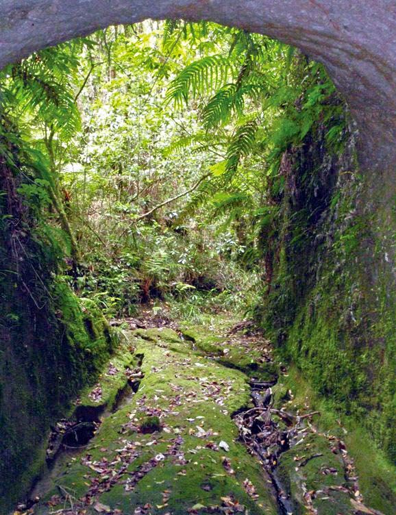
Rotorua29 ...continued
TECT All Terrain Park
Te Rerenga Trail
If you are looking for light at the end of the tunnel
then this walk is for you.
This 3.2 kilometre medium grade loop track is popular
with walkers and runners. It winds through mature
pine forest and the bush clad gully of the
Te Rerenga Stream.
The gully is reasonably steep but the track is well
formed with stairs on steeper sections. The trail
follows the stream on the gully floor over a series
of boardwalks.
To begin the ascent you enter a 60 metre tunnel,
dug in the last century, to divert the stream under
the Tauranga/Rotorua (SH36) road, that was being
built at the time.
The tunnel was built by hand over a three-year
period and the walls and roof show evidence
of the hand tools used to excavate.
Glowworms feature on the tunnel roof and cave weta
inhabit the crevices and holes. A short climb goes to
Peterson’s Camp where Mr Peterson and his road crew
lived during the tunnel construction. The trail follows
the creek bed and breaks in to cutover forest before
once again entering a mature pine forest. The trail
follows Weld Road back to the start of the trail at
the Arrival Centre carpark.
There are slippery sections and stairs, so good
footwear is essential. It’s useful to have a torch
to navigate the tunnel and always take a jacket
for protection as the wind and rain can be very
chilly at this elevation.
westernbay.govt.nz 67J002168 DEVCICH.CO.NZ westernbay.govt.nz Te Kaunihera a rohe mai i nga Kuri-a-Wharei ki Otamarakau ki te Uru
You can also read