WARNER TRAIL - FOXBOROUGH SECTION
←
→
Page content transcription
If your browser does not render page correctly, please read the page content below
WARNER TRAIL – FOXBOROUGH SECTION
After hiking and taking photos of the Warner Trail, Eric Nelson (Foxborough’s newest Conservation
Commissioner) created a PowerPoint presentation of his findings which, unfortunately, was too large to be
easily downloaded. His original presentation was converted into this Word document for your reading pleasure.

                                                 Introduction
The basic descriptive information about the trail (and various distances), shown in quotes, was copied from the
Warner Trail Guidebook (as per link above). However, Eric provided all of the other information and
recommendations, as well as all of the beautiful site photos.
On-line information about the Warner Trail from the "Friends of the Warner Trail" is available at the following
site: http://www.warnertrail.org
The site has historical information, some maps (though at a pretty high level), and a helpful guidebook for the
trail: http://www.warnertrail.org/Guidebook2008%20Rev%2004.pdf
Trail Map through Foxborough: http://www.warnertrail.org/Warner3-4.pdf

                                          WARNER TRAIL MARKERS

Well-marked Warner Trail Sign along Upper Dam Pond            Best Warner Trail Marker in Foxborough – junction
                                                              with Acorn Trail in F. Gilbert Hills State Forest

                                  SHARON LINE (AREA) INTO FOXBOROUGH

”The trail turns L off South Walpole St. at the bend in the street (utility pole #46) on an unused, indistinct, and
overgrown dirt road (Dudley Hill Road). Cars must not be parked here, private land. Take care to go around the
end of a blocking fence without damaging the bushes (intended to discourage all but pedestrians). Stay in the
woods to the R of the blocking fence and the large pine tree and work your way to the back yard of the white
house. Walk along the edge of the yard until you reach the woods in the R rear corner of the yard. The trail then
continues on a path from the rear of the yard. Caution, this section of the trail around the fence and through the
yard is purposely indistinctly marked to discourage all but hikers from using the private property.
Keeping R at the first fork the trail follows a mostly straight woods road through swampy areas. In 0.5 mi. from
South Walpole St., the trail turns R 45° off of the woods road onto a smaller path and winds through a swamp to
a berm. The trail climbs onto the berm, turns L for a few yards and forks R to drop down through more swamp
and a series of bridges built by Boy Scouts. After crossing over the bridges and passing behind a brown house
on the L, the trail passes through a stone wall and turns L, keeping the wall on the L until it approaches a white
house. The trail bends R [actually it bends L] away from the wall and in 40 yd. goes to a gap in a snow fence
between two houses. It then goes directly towards Beach St. along the edge of two adjoining lawns to a utility
pole and the pavement. The trail turns R onto Beach St. for 50 yd. and then turns L (S) on a right of way (just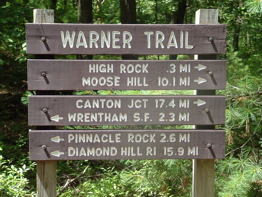
SHARON LINE (AREA) INTO FOXBOROUGH (CONTINUED)

beyond a large pin oak and a wooden fence), through a row of large rocks to a gravel motor bike road, 50 yd.
from Beach St. The trail then turns L on the gravel road which it follows, curving R, 0.2 mi. to Edwards Rd.,
where cars can be parked. Watch for a future relocation in this gravelly area.”
“Distance from South Walpole St. (S):
      to R turn off woods road: 0.5 mi.
      to Beach St.: 0.7 mi.
      to Edwards Rd: 1.0 mi. “

                               Highlights – Sharon Line (area) into Foxborough

         Cranberry Bog off S. Walpole Street                            Swampy section before Beach St

Parking:
There is no readily available parking on South Walpole Street, so your best (and safest) option is to park on
Blair Circle, which is only approximately an 1/8th mile to the start of the trail.

Trailhead(s):
The marker of Utility Pole #46 is key to finding the beginning of the trail off of South Walpole Street. The old
Dudley Hill Road is truly indistinct and becoming overgrown. Several yards in off of South Walpole Street, there
is a rope to "block" what once may have been Dudley Hill Road. It is easy to simply follow the stone
wall (perpendicular to South Walpole St), which will take you to the trail behind the houses. As per the
guidebook, there are no trail markings at the very beginning (deliberately) to preserve privacy for the homes.
The trailhead off of Beach St is well-marked with several Warner Trail signs as you begin to move into the Trail.

Trail Markings & Conditions:
It is important to look carefully for trail markings as some are not easily visible, and in a few cases some need to
be repaired. Accordingly, it is easy to get sidetracked on other trails in the area, which in general is a
combination of dry and swampy land.
At the same time that some trail marking enhancement is preferred, there could be opportunity to repair/improve
a section of the bridges built by the boy Scouts before the trail moves to Beach Street. However, given the
amount of rain Foxborough received in the spring and summer of 09, it was surprising to see how well the trail
was maintained, with only a few other minor instances of tree trunks or other debris along the main paths.

Other Advice to Hikers:
This part of the trail is "easy to moderate" except for the bridge section within the swampy land at the end near
Beach Street. This trail should be avoided in particularly wet conditions, and insect repellant should definitely be
applied before hiking. The views of the cranberry bogs are not wide open, but you can go through the woods to
get better views. Finally, the other paths in the area (not Warner Trail) provide additional opportunities to view
the wetlands close-up.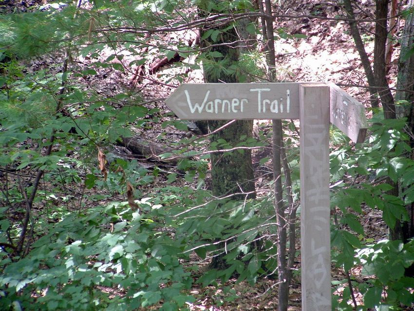
EDWARDS RD TO END OF CUL-DE-SAC ON MONROE ST
“The trail turns R onto Edwards Rd. and follows on the sidewalk for 0.6 mi. Then the trail turns L, off the street
(utility pole #27) and climbs a bank between two houses. The brush grows quickly on this bank so look carefully
for the trail. At the top of the bank, the trail goes through a short stretch of woods and drops down to the L,
crossing a barrier, onto the gravel Camp Road near two houses. This barrier is intended to keep all but hikers
from using this private property. For the next 0.6 mi., the trail is on roads. The trail follows Camp Road for 0.2
mi. and then turns L (S) into the Whispering Pines development on McCasland Way for 0.15 mi., then L on
McKenzie Lane for 0.15 mi. and then L on Munroe St. for 0.1 mi. to the cul-de-sac. From the cul-de-sac the trail
reenters a pine woods on the Foxborough Conservation Property (sign).”
“Distance from Edwards Rd. (N):
to L turn off Edwards Rd.: 0.6 mi.
to Foxborough Conservation Property: 1.3 mi.”
This is a mainly settled/suburban stretch of the Warner Trail and therefore parking is easily available.
The trailhead is well-marked at utility pole #27 off Edwards Road, but there is some deterioration of the fence
barrier near Camp Road, and there is no Warner Trail sign as you enter or leave Camp Road (this may be by
design given the houses nearby).
Harder-core hikers might wish to avoid this section of the trail and start at the end of the Monroe St cul-de-sac
per below. If not, the Warner Trail Guidebook along with a simple map of Foxborough will make the directions
for this easy hike clear.
MONROE ST, CUL-DE-SAC (FOXBOROUGH CONSERVATION PROPERTY) TO
FOXBOROUGH CONSERVATION PARKING LOT (OFF 140)
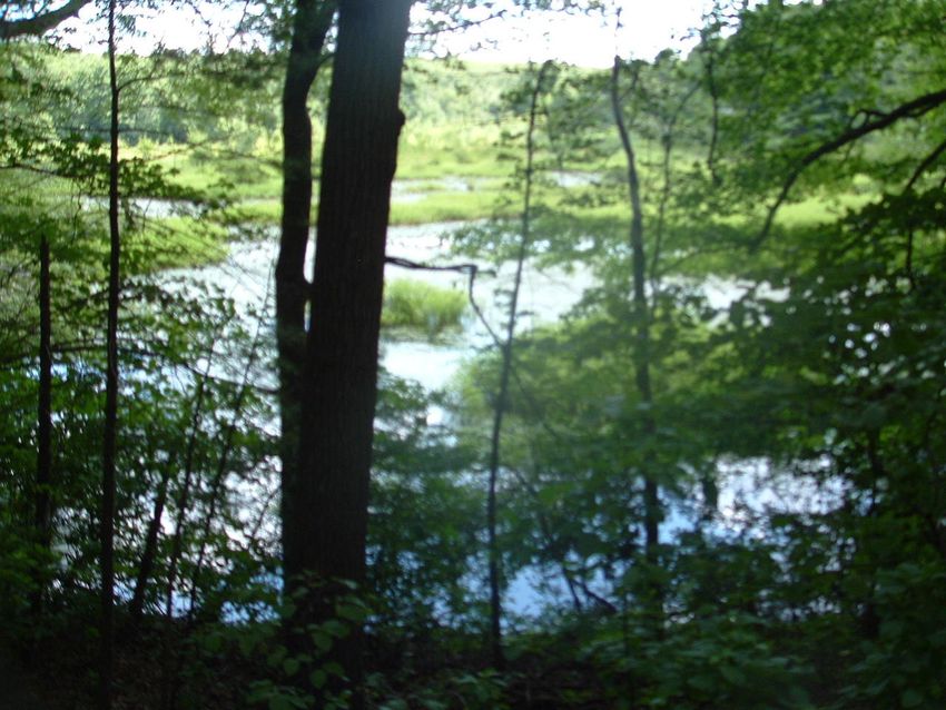
“The trail goes mostly S through the open woods, with the Neponset Reservoir on the L, for 0.4 mi. to the dam at
the outlet of the reservoir. Turning R beyond the dam and up a rise the trail goes SW until it turns L (S), just
before coming to a RR track, and goes parallel to the tracks on several bog bridges to Chestnut St. (a good
parking area). The trail turns R (W) on Chestnut St. and proceeds along the street passing through the Chestnut
Green mixed-use community at the site of the former Foxborough State Hospital. As the trail approaches the
rotary, it turns L onto North St. and proceeds to the pedestrian traffic light next to the Sharon Credit Union.
Crossing with the light towards the Dairy Queen, the trail turns L (S) on Main St. (Mass. 140) for a 170 yd. to
turn R into the Foxborough Conservation parking lot.”
“Distance from Foxborough Conservation Property (Munroe St. cul-de-sac)
to Foxborough Conservation parking lot: 1.5 mi.”
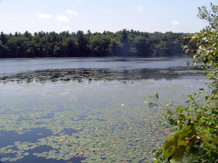
Highlights -- Monroe St cul-de-sac to Foxborough Conservation parking lot
Meadow off Monroe St. cul-de-sac Neponset Reservoir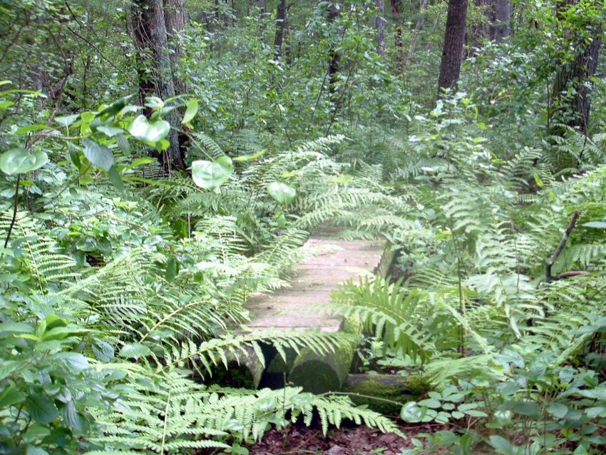
MONROE ST, CUL-DE-SAC TO FOXBOROUGH CONSERVATION PARKING LOT (continued)

Parking & Trailhead:
The Munroe St cul-de-sac offers convenient parking and the Trailhead is well-marked and easily accessible.
Trail Markings & Conditions:
Most of the Trail markings on this section of the trail are in good shape, and are plentiful enough to keep a hiker
on the right path. There is a trail marker or two that could be repaired or fixed (but minor). Most of this section
of the Trail is also in fine condition, exception being a minor bridge repair near the end (but you can easily stay
dry). In addition, there is a large tree that has fallen at the end of the trail section that should be cut.
Advice to Hikers:
Hikers may want to bring family along on this section of the Trail because it is still easy-moderate, but, until
exiting onto Chestnut Street, the trail stays in wooded areas and offers a variety of points of interest: (views of
the Neponset Reservoir, large open field, a beautiful pine forest, the old Neponset Dam, and a parallel path to
railroad tracks near the end, though you stay a safe distance away.) In addition, at the end, you will walk
through boggy/swampy areas, but these are less intense than the wetlands in the Sharon (line) to Foxborough
stretch area. Wear bug repellant nonetheless.

                     FOXBOROUGH CONSERVATION PARKING LOT TO LAKEVIEW RD
“The trail follows a lane W out the back of the lot into the woods on Foxborough conservation property, turning R
at the trail junction in 0.4 mi. The trail continues through the woods until it reaches Lakeview Rd. As the trail
approaches Lakeview Rd. it bears L and heads downhill towards a brook. It then swings to the R and follows
alongside the brook out to Lakeview Rd.”
“Distance from Foxborough Conservation parking lot
      to Lakeview Rd.: 0.8 mi.”
The trailhead off of 140, the Foxborough Conservation parking lot, is also easily accessible and is clearly
marked via the large Rock (with Conservation inscription) near the entrance.
The trail is pretty well-marked and accessible in this brief section. The beginning of this section runs parallel to
the new entrance road for the new Governor’s Meadow subdivision (but far enough away so that you are not in
neighbors’ backyards). There are some wetlands near the trail before the major junction at .4 miles, with the
trail becoming “less wet” as you continue with the right hand turn.
Note that the major left indicated in the guidebook –
      “As the trail approaches Lakeview Rd. it bears L and heads downhill towards a brook”
– is very well-marked by signage and also by a small wooden fence.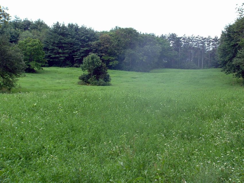
LAKEVIEW RD TO HIGH ROCK PARKING LOT
”The trail turns L(S) on the pavement and crosses the dam for Lakeview Lake for 120 yd. After crossing the
dam, the trail turns R off the pavement, goes around a gate, reenters the woods and follows the conservation
lane with the lake on the R. A few cars can be parked off the road, but do not block the gate. In 160 yards from
Lakeview Rd. the trail turns L onto another path and continues W until it comes to Upper Dam pond 0.3 mi. from
Lakeview Rd. It goes across the dam (using Boy Scout built stiles), turns L(S) and swings SE around the pond
to Messenger Rd. (a gravel fire road) where the trail turns R (SW) and up a long climb toward High Rock in the
F. Gilbert Hills State Forest). As the road nears the top, the trail forks R on an old woods road (where an
emergency shelter 1.2 mi. from Lakeview Rd. can be used during inclement weather) and climbs until just prior
to a fenced-in old radar test station where it turns L at the foot of a large boulder (High Rock itself) and follows a
short path over the rise to the gravel parking area at the foot of a mammoth microwave relay tower and base
building. A paved road, maintained by AT&T goes down to US 1 about 0.4 mi. S of the intersection of US 1 and
Mass. 140.”
“Distance from Lakeview Rd. (S)
      to High Rock parking lot: 1.6 mi.”
                              Highlights -- Lakeview Rd to High Rock Parking Lot

                Upper Dam Pond Entrance                               Emergency Shelter .4 miles from High Rock

                                                    Upper Dam Pond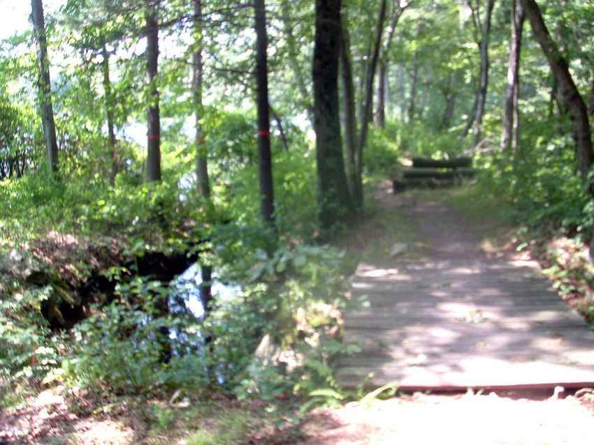
LAKEVIEW RD TO HIGH ROCK PARKING LOT (CONTINUED)
Parking:
It is not recommended to attempt to park right next to the Lakeview Road continuation of the Warner Trail.
Parking is normally very limited, but in recent years, rocks have been added near the entrance to the trailhead,
which may wreak havoc on car tires. Park on nearby Forest Road, which intersects Lakeview Road (just up the
hill on Lakeview Road, farther way from 140) and walk back down to the entrance.
Trailhead(s):
Note that the trailhead is very well-marked with a Conservation Property sign and a white stainless steel disc
within yards of the entrance. You will walk near the side of Lakeview Pond until the trail banks left in
approximately 160 yards (as per the guidebook.)
This part of the trail will take you into the Harold B Clark Town Forest* initially and then you will meet up with the
F Gilbert Hills State Forest** along Messenger Rd farther along the trail.
Trail Markings & Conditions:
This part of the trail is pretty well-marked, fairly open, and easy to follow, with a few exceptions. In general, be
sure to look for the signature single, white or stainless steel discs that mark the Warner Trail.
Please obtain a map of the F. Gilbert Hills State Forest Hiking Trails**. While only a high level view, the map
available on this site shows the Warner Trail through the State Forest and provides a good visual of how the trail
leads to Route 1 in Wrentham. The two areas that you should pay close attention to along this stretch to stay on
the right path are the following:
1) As you approach the pristine Upper Dam 0.3 miles from Lakeview Road, continue to look closely for the
white disc markers and the gap in the stone wall that will take you down along the water. Keep the Dam on
your left. Once you cross a wooden bridge as you approach the water and climb over a wooden horse
jump, you are on the correct path as long as the water is on your left.
2) After you turn right on Messenger Road (obvious gravel fire road but not marked until later on the road), you
will need to look closely for the correct Right Fork where the old woods road will take you past the
emergency shelter. There are some other potential forks to the Right before the Warner Trail (one has
Green & Yellow markings). You will know you are on the right fork by seeing the white disc markers several
feet in and, within 50 yards or so, you should see the emergency shelter on your right. On this section,
there was only one instance of a small tree that had fallen into the path on the old woods road portion.
Maintenance of the trail was very good.
Other Advice to Hikers:
Note that this part of the trail is probably the second most difficult section of the Warner Trail through
Foxborough. As you turn right on Messenger Road (per guidebook), the climb is indeed fairly long, though not
excessively steep. In addition, the path turns fairly rocky as you swing left around the Upper Pond (after the
distinct Warner Trail sign) until the old woods road off of Messenger Road.
The final stretch (old woods road) to High Rock itself becomes a narrower trail (and of course, bug repellant is
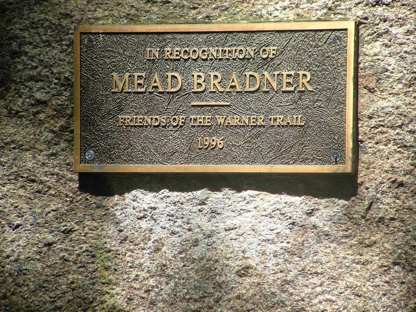
key). Finally, High Rock is marked by a plaque to Mead Bradner, a representative of the Warner Trails Advisory
Committee (on the S.E. section), who established the Friends of the Warner Trail in 1994.
*Harold B. Clark Town Forest:
www.trails.com/tcatalog_trail.aspx?trailid=XAC006-027&source=CDI&oc=CDI1&track=1
**F Gilbert Hills State Forest: www.mass.gov/dcr/parks/southeast/fgil.htm
“Covering 1,027 acres in Foxborough and Wrentham, F. Gilbert Hills is a "passive use" pine and oak
forest. There are 23 miles of trails for various uses, looping through the forest. One of these leads to the
Warner Trail, a long-distance hiking trail that travels through Norfolk County on its way to Rhode Island.
Mountain Biking is a widely popular activity and there are also trails for ORVs and horseback riding. “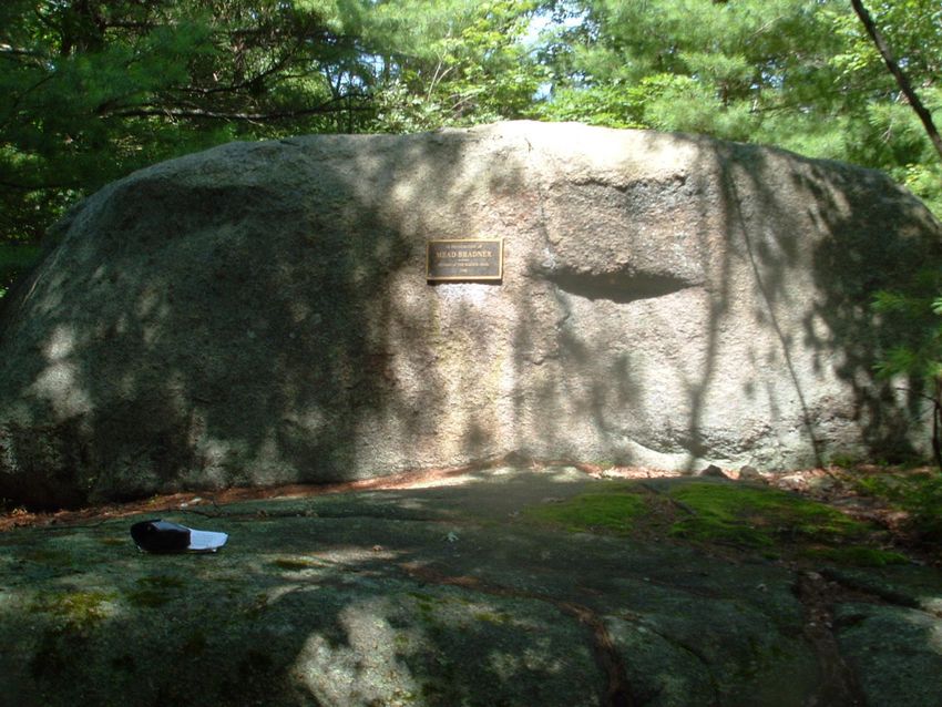
HIGH ROCK (PARKING AREA) TO RT 1 (WRENTHAM)
“To reach the NE end of this section of the Warner Trail take the paved road (High Rock Road) leaving US 1 L
(S) approx. 0.4 mi. S of the junction of US 1 and Mass. 140 to the gravel parking area next to the gate to the F.
Gilbert Hills State Forest, near the foot of the Microwave tower. Do not park on the AT&T paved parking area,
and do not block the fire lane gate. The trail leaves the E end of the parking area on the R (W) side of the barrier
gate. At 80 yd. the trail turns L and follows a winding path, dropping down and passing under the overhanging
cliff of Goat Rock. (Look for tree growing out of rock). The trail swings R and over a number of large rocks,
crossing an underground stream, and continuing on an arc to a trail junction. The trail turns L and climbs up the
stone steps to a large Warner Trail sign at the junction with the Acorn Trail at 0.4 mi. (The Acorn Trail is a 2.2
mi. rugged feeder trail from the Forest Headquarters on Mill St., Foxborough). The trail then goes S and in 40
yd. bears L for a short distance to the top of a large rock slab from the top of which there is an excellent view to
the W. The trail descends SW on the ledges approx. 80 yd. to the base and reaches a woods road in another 30
yd. The trail turns R (NNW) on the woods road for 0.4 mi., passing two towers on the L, crosses through a stone
wall and turns L on a small path. This small path crosses two mountain bike trails and bears L onto a woods
road down a short distance to US 1 which it crosses (CAUTION) onto Myrtle St. (Wrentham).”
“Distance from High Rock gate
      to Goat Rock.: 0.2 mi.
      to Acorn Trail: 0.4 mi.
      to R turn at base of ledges: 0.6 mi.
      to L turn onto small path: 0.9 mi.
      to Route 1: 1.3 mi.”
                          Highlights -- High Rock (parking area) to Rt 1 (Wrentham)

                                             View from the Ledges – Looking W.

                           High Rock                                     Close Up of Plaque Commemorating
                                                                         Mead Bradner’s Work for Warner Trail
HIGH ROCK (PARKING AREA) TO RT 1 (CONTINUED)
Parking:
Well-described as per the guidebook

Trailhead(s):
The trailhead to the R (W) side of the large barrier gate (before the prominent Fire Road) is well-marked with
triangular Warner Trail marking(s). However, almost immediately, the trail narrows considerably and you must
stay vigilant in looking for the white or stainless steel discs to stay on the right path (there are immediately other
crisscrossing trails that are wider). If you are not seeing a huge set of rock structures to your left in .2 mi (Goat
Rock), then you should circle back and start again from the Trailhead.

Trail Markings & Conditions:
This portion of the Warner Trail is solely within the F. Gilbert Hills State Forest and is the most difficult section of
the trail through Foxborough (as it meets up with Wrentham and Rt 1) for the following reasons:
1) There is a steep section through the ledges portion and the path is essentially on rock slabs.
2) The path is particularly narrow in stretches, and without careful observation of Warner Trail signs and
   markers, a hiker can easily be confused by other crossing trails that are wider and more accessible
3) In addition to the narrowness, the actual maintenance of the trail deteriorates by the last .4 miles, which is in
   Wrentham
Again, please obtain a map of the F. Gilbert Hills State Forest Hiking Trails via
http://www.mass.gov/dcr/parks/southeast/fgil.htm so that you can have a high-level orientation of where you are
walking in the forest.
Good landmarks for this section besides Goat Rock are certainly the Warner Trail sign at the junction with the
Acorn Trail (.4 miles from High Rock) – this is the best preserved and clearest Warner Trail marking in
Foxborough. In addition, as you climb the ledges and hike from rock to rock, you should be high enough
(eventually) to get a good, open view of the West (otherwise you may be slightly off the path).
Two pieces of advice about the following description from the guidebook:
“The trail turns R (NNW) on the woods road for 0.4 mi., passing two towers on the L, crosses through a stone
wall and turns L on a small path.”
1) When you take this right, you will want to stay straight on the path by carefully paying close attention to the
   white or stainless steel discs, even though other forks or crisscrossing paths may be better marked and
   more accessible (wider).
2) The “L on small path” is truly indistinct, since the white or stainless steel discs aren’t easily visible until you
   are slightly on the new path. Your best guide is to be on the lookout for this left as soon as you cross the
   through the stone wall.

Other Advice to Hikers:
The deterioration in the last .4 miles of the trail is not insignificant. It is narrow, wet, and hard to follow.
Listening for the sound of Rt 1 will ensure that you continue to make progress to the highway.
You can also read