Warnervale District Contributions Plan - Main Document
←
→
Page content transcription
If your browser does not render page correctly, please read the page content below
Warnervale District
Contributions Plan

   Main Document

                      May 2021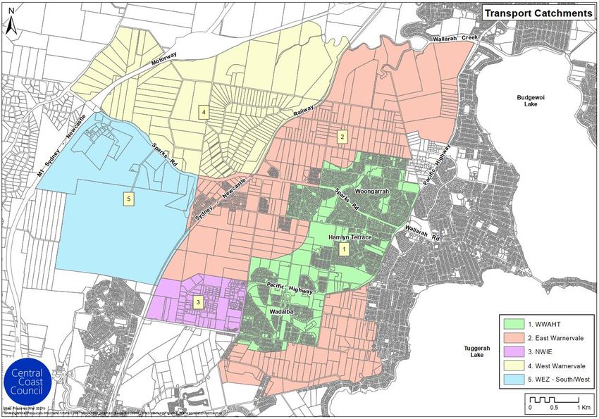
Table of Contents

Contents
1.     Introduction                                                                         1
      1.1     Plan summary                                                                  1
      1.2     Legislative requirements                                                      2
      1.3     How to use this plan                                                          3
      1.4     Name of this plan                                                             3
      1.5     Commencement of this plan                                                     3
      1.6     Purposes of this plan                                                         4
      1.7     Land to which this plan applies                                               4
      1.8     Development to which this plan applies                                        5
      1.9     Exempted development from contributions                                       7
      1.10    Local infrastructure for provision under this plan                            7

2.     Contributions rates and calculations                                                 9
      2.1     Residential development contribution rates                                    9
      2.2     Environmental corridor and floodplain restoration contributions              12
      2.3     Stormwater quality contribution exemptions                                   12
      2.4     Calculating residential development contributions                            14
      2.5     Non-residential development contribution rates                               15
      2.6     Calculating non-residential development contributions                        17

3.     Infrastructure needs, costs and staging                                            18
      3.1     Developable land                                                             18
      3.2     Occupancy rates and population projections                                   18
      3.3     Non-residential demand                                                       19
      3.4     Nexus for the infrastructure and apportionment of costs                      19

4.     Contributions requirements and settlement                                          30
      4.1     Timing of payments                                                           30
      4.2     Policy on deferred or periodic payments                                      30
      4.3     Infrastructure delivery requirements in conditions of consent                31
      4.4     Other contributions to be taken into account                                 32
      4.5     Obligations of Accredited Certifiers                                         33
              4.5.1       Complying Development Certificates                               33
              4.5.2       Construction Certificates                                       333

Draft Warnervale District Contributions Plan 2021                                          Page ii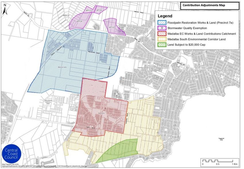
Table of Contents

      4.6     Indexation of contribution rates under this plan                                             34
      4.7     Adjustment to contributions on payment                                                       34
      4.8     Contributions by land dedication or undertaking works                                        35
              4.8.1       Consideration of works or material public benefit offers                         36
              4.8.2       Agreements to be in writing                                                      36
              4.8.3       Valuation of works in kind, land and other material public benefits              37
              4.8.4       Dedication of land required under this plan                                      37
              4.8.5       Temporary works                                                                  37

5.     Other administration matters                                                                       38
      5.1     Relationship to other plans and policies                                                     38
      5.2     Savings and transitional arrangements                                                        38
      5.3     Pooling of funds                                                                             38
      5.4     Goods and services tax                                                                       38
      5.5     Accountability and access to information                                                     39
      5.6     Review of contributions plan                                                                 39
      5.7     Definitions                                                                                  39

Draft Warnervale District Contributions Plan 2021                                                         Page iii
Table of Contents
Figures
Figure 1 Warnervale District plan application 5
Figure 2 Warnervale District transport catchments for contributions in this plan 6
Figure 3 Areas where contribution adjustments apply 13
Tables
Table 1 Summary of infrastructure costs to be funded by the Plan 8
Table 2 Summary of environmental corridor and floodplain restoration costs to be funded by
the plan 8
Table 3 Residential contributions summary of base rates and adjustments (if applicable) 10
Table 4 Assumed occupancy rates for calculating contributions and demand credits 12
Table 5 Environmental corridor and floodplain restoration contributions 12
Table 6 Non-residential contributions ($ per ha of NDA) 15
Table 7 NDA by catchment and assumed densities for residential NDA 18
Table 8 Population projections summary for Warnervale District 19
Table 9 Planned open space provision for Warnervale District 20
Table 10 Proposed Warnervale District community facilities 21
Table 11 Apportionment of transport costs by catchment 24
Table 12 Stormwater infrastructure NDA, population and costs 27
Draft Warnervale District Contributions Plan 2021 Page ivIntroduction
1. Introduction
1.1 Plan summary
Warnervale is located in the North Wyong region of the Central Coast Local Government Area (LGA). The
Warnervale District includes the suburbs of Warnervale, Woongarrah, Hamlyn Terrace, Wadalba, Kanwal,
Halloran and parts of Wyong and Jilliby.
The Central Coast Regional Plan 2036 identifies Warnervale as a regional growth centre as it undergoes
transformation from a semi-rural district to an urban residential and employment hub. By 2036, it is planned
to accommodate almost 11,900 new dwellings for more than 36,200 people and generate significant
employment growth.
The types of public amenities and public services required to meet the demands of the expected future
development, and for which the costs are included in this plan, are as follows:
▪ local and district parks;
▪ local and district sporting and recreation facilities;
▪ local and district community facilities;
▪ local and district roads, cycleways and intersections;
▪ drainage and water quality works;
▪ environmental corridors; and
▪ plan studies and administration.
The total costs of infrastructure provision in the plan amount to approximately $354.7 million. For most of the
infrastructure facilities, Council is funding the full cost from contributions. However, for some facilities, such as
the Indoor Recreation Centre, the costs are shared with the broader rate base due to the shared demand with
existing residents in the region.
The objectives of this plan are to ensure:
▪ consent conditions are authorised;
▪ there is a demonstrated nexus between the works and the development areas identified to
contribute to the cost of those works;
▪ the equitable apportionment of costs among development; and
▪ that reasonable contribution rates are applied in all parts of release areas.
This plan repeals the Warnervale District Contributions Plan 2014 (former plan). The former plan reflects the
infrastructure planning in predecessor contributions plans for the Warnervale Town Centre (WTC) (from 2012)
and the Wadalba, Woongarrah and Hamlyn Terrace (WWAHT) release area (from 2013). These separate plans
were integrated back into the contributions plan for the broader Warnervale District in 2014.
Draft Warnervale District Contributions Plan 2021 Page 1Introduction
This plan consolidates multiple sub catchments for drainage and open space into a single catchment to better
streamline the different contributions payable by development. It also consolidates 11 former catchments for
transport into 5 catchments, which reflects a practical grouping of traffic network sub catchments east and
west of the railway line.
The planning and development of Wadalba, Woongarrah and Hamlyn Terrace (WWAHT) and Warnervale Town
Centre (WTC) is well underway. Central Coast Council1 (Council) has levied contributions for development
already progressed under predecessor contributions plans, or in accordance with planning agreements with
developers. Therefore, some of the infrastructure included in this plan has already been provided and costs
already incurred are being recouped through contributions.
The plan also includes South East Wadalba (SEW) precinct (also referred to as ‘Wadalba South’) and Bruce
Crescent Precinct, which is to be rezoned for urban development in the future. Council has made assumptions
about the anticipated land uses and the public services and amenities that will be required in Bruce Crescent,
once developed. Once this area is rezoned, Council may need to review the plan to accommodate any material
differences in these assumptions. This plan does not include drainage or water quality infrastructure
contributions for West Warnervale, which includes Bruce Crescent and other Wyong Employment Zone (WEZ)
land, because the needs have not yet been scoped or costed. Once again, the plan may require reviewed to
include these costs once known.
1.2 Legislative requirements
This plan is predicated on the assumption that the development of land generates additional demand for
infrastructure which necessitates new or augmented infrastructure. The authority for local councils to require
contributions of money, land or works to help meet those additional demands is contained in the legislation.
Section 7.11 of the Environmental Planning and Assessment Act 1979 (EP&A Act) authorises a consent authority,
responsible for determining a development application, to grant consent to a proposed development subject
to a condition requiring the payment of a monetary contribution and/or the dedication of land free of cost
towards the provision of public amenities and public services.
Where the consent authority is a council or an accredited certifier, a contribution under Section 7.11 of the
EP&A Act may only be imposed on a development if it is of a kind allowed by and determined in accordance
with a contributions plan, such as this plan.
This plan enables Council to levy Section 7.11 contributions for certain public amenities and public services in
the Warnervale District where new development will or is likely to increase the demand for such amenities and
services.
This plan has been prepared in accordance with the requirements of the EP&A Act and the Environmental
Planning and Assessment Regulation 2000 (EP&A Regulation).
1
Formerly Wyong Shire Council before Gosford City Council and Wyong Shire Councils were amalgamated in 2016.
Draft Warnervale District Contributions Plan 2021 Page 2Section 1 Introduction
1.3 How to use this plan
The plan is structured in the following way.
Main Document (this document):
▪ Part 1 contains an introduction to the plan, the name of the plan, the date on which the plan
commenced, the plan’s purpose, and a description of the land and types of development
affected by this plan.
▪ Part 2 contains summaries of contribution rates and the assumptions informing the derivation
of the contribution rates. It also contains guidance on how to calculate a contribution for any
development affected by the plan.
▪ Part 3 provides information about how and when contributions shall be imposed on
developments.
▪ Part 4 describes how a contribution may be settled by a developer once it has been imposed
by a consent authority on a development consent.
▪ Part 5 contains other provisions relevant to the administration of section 7.11 contributions
relating to development in the Warnervale District.
Technical Document:
The accompanying Technical Document contains:
▪ detailed information on the assumptions that have been used to determine the contribution
rates in this plan;
▪ information on the projected demand for infrastructure from the expected development;
▪ the infrastructure that has been planned and how it is proposed to be delivered;
▪ other relevant information that has been used to determine the contribution rates;
▪ the schedules of land to be acquired and works to be undertaken, and
▪ maps showing the location of proposed infrastructure.
1.4 Name of this plan
This contributions plan is called the “Warnervale District Contributions Plan 2021” (the plan).
1.5 Commencement of this plan
This plan commences on the date on which public notice was published, pursuant to clause 31(4) of the EP&A
Regulation.
Draft Warnervale District Contributions Plan 2021 Page 3Section 1 Introduction
1.6 Purposes of this plan
The primary purpose of this plan is to authorise:
▪ Council, when granting consent to an application to carry out development to which this plan applies;
or
▪ an accredited certifier, when issuing a complying development certificate for development to which this
plan applies,
to require a contribution to be made towards:
▪ the provision, extension or augmentation of public amenities and public services only where
development is likely to require the provision of or increase the demand for public amenities and public
services; and
▪ the recoupment of the cost of providing existing public amenities and public services within the area to
which this plan applies.
Other purposes of the plan are:
▪ to provide the framework for the efficient and equitable determination, collection and management of
development contributions toward the provision of public amenities and public services generated by
development within the area;
▪ to determine the demand for public amenities and public services generated by the incoming population
to the area and ensure that development makes a reasonable contribution toward such public amenities
and services that are required for that population;
▪ to ensure that the existing community is not unreasonably burdened by the provision of public amenities
and public services required (either partly or fully) as a result of development in the area; and
▪ to ensure Council’s management of development contributions complies with relevant legislation and
practice notes and achieves best practice in plan format and management.
Contributions from development levied under this plan will not be used to address any backlog in the provision
of works and services for the existing population, including in surrounding districts.
1.7 Land to which this plan applies
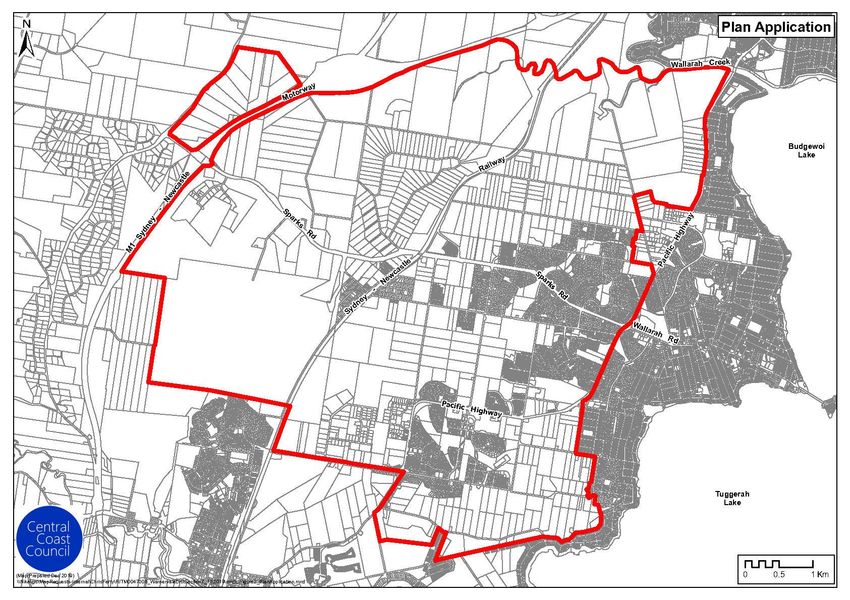
This plan applies to all development situated within the Warnervale District as shown in Figure 1. This also
provides the different development areas within the District.
Figure 2 shows the five catchments for which different transport contributions are levied under this
contributions plan. The section below explains the development areas and catchments in more detail.
Draft Warnervale District Contributions Plan 2021 Page 4Section 1 Introduction
Figure 1 Warnervale District Plan application
1.8 Development to which this plan applies
Development within the application areas of this plan (Figure 1), which will likely increase the demand for or
require the provision of public services and amenities, are subject to this plan.
The type and amout of contributions applicable to any development will be determined by:
▪ the form of the development proposed; and
▪ the location of the development site.
Draft Warnervale District Contributions Plan 2021 Page 5Section 1 Introduction
Figure 2 Warnervale District transport catchments for contributions in this plan
Note: NWIE is the North Wyong Industrial Estate and WEZ is the Wyong Employment Zone.
1.8.1 Contributions catchments
The costs of open space, recreation, community facilities, drainage and stormwater quality infrastructure are
levied across all of the development areas in the Warnervale District as a single catchment.
Transport contributions are levied on five separate catchments including the East and West Warnervale
catchments and other distinct development areas. The five transport catchments and associated development
areas within the Warnervale District that this plan applies to are:
1. Wadalba, Woongarrah & Hamlyn Terrace (WWAHT)
2. East Warnervale transport contributions catchment, which includes:
a. Precinct 7A
b. Warnervale Town Centre (WTC)2
c. South & East Wadalba (SEW)
d. Precincts 8 and 9
3. North Wyong Industrial Estate
4. West Warnervale transport contributions catchment, which includes:
2
Only the WTC east of the railway line is included in the transport catchment.
Draft Warnervale District Contributions Plan 2021 Page 6Section 1 Introduction
1. WTC West (west of the railway line)
2. Wyong Employment Zone (WEZ) Mountain Road
3. Precinct 14
4. Bruce Crescent
5. WEZ South/West and Education Site
The estimated dwelling and population yields and Net Development Area (NDA) assumptions in this plan for
each catchment are provided in Tables 7 and 8 in Section 3.1. More detail on each of these catchments and
development areas are contained in the Technical Document (Section A1).
1.9 Development exempt from Contributions
The following developments are exempt from the requirement to make a contribution under this plan:
▪ development for the sole purpose of adaptive reuse of an item of environmental heritage.
▪ seniors housing development defined in State Environmental Planning Policy (Housing for
Seniors or People with a Disability) 2004 that is provided by a social housing provider (not self-
contained dwellings forming part of seniors’ housing development).
▪ development for drainage, water quality works, utilities, open space, community facilities or
transport infrastructure purposes to be provided by State Government or Council;
▪ development exempt from section 7.11 contributions by way of a direction from the Minister
for Planning and Public Spaces under section 7.17 of the EP&A Act; and
▪ any other development that in the opinion of Council does not increase the demand for the
categories of public facilities and services addressed by this plan.
Exemptions are subject to the applicant providing a written justification (with the development application)
that demonstrates to Council’s satisfaction that the exemption is warranted, with relevant supporting evidence.
Developments on land where developers are required to provide onsite water quality treatment as part of
development consents are exempt from water quality contributions only. These are identified in Section 2.3
and Figure 3.
1.10 Local infrastructure for provision under this plan
The total value of the various categories of public amenities and public services that will be funded by
contributions under this plan, excluding environmental conservation works, is summarised in Table 1. The value
of works (including land) represents both the value of expenditure that has been completed to date and the
value of remaining works that are yet to be completed.
For some infrastructure categories, certain item costs are not being fully funded by contributions but are shared
with the existing rates base. More detail on the infrastructure strategies and apportionment of costs in the plan
is contained in Section A2 of the Technical Paper.
The total value of environmental conservation works (including land) related to the Wadalba Environmental
Corridor and floodplain restoration works in Precinct 7A is in Table 2. These costs are recovered in
contributions from the sub catchment areas which directly benefit from the works.
Draft Warnervale District Contributions Plan 2021 Page 7Section 1 Introduction
The costs in Tables 1 and 2 are in December 2020 dollars, reflecting the base period of the plan. 3
Table 1 Summary of infrastructure costs to be funded by the plan
Category Value of projects under the plan
Open Space Land $41,612,632
Open Space Works $52,087,514
Community Facilities Land $1,521,386
Community Facilities Works $42,030,196
Transport Facilities Land $7,833,040
Transport Facilities Works $115,765,883
Drainage/Water Quality Land $15,227,205
Drainage and Flood Mitigation Works $43,242,402
Water Quality Works $25,138,118
Plan studies and administration $10,305,582
TOTAL PLAN COSTS $354,763,958
Note: Plan costs exclude environmental corridor / floodplain restoration costs which are shown in Table 2.
Table 2 Summary of environmental corridor and floodplain restoration costs to be funded by
the plan
Category Value of projects under the plan
Wadalba Corridor Land $2,319,377
Wadalba Corridor/Environmental Corridor
$1,461,302
Works
South Wadalba Environmental Corridor Land $1,370,453
Addition to Wadalba Corridor $2,142,041
Precinct 7A Floodplain restoration works $893,928
TOTAL PLAN COSTS $8,187,101
3
Some land is also included at its unindexed value (e.g. for the ‘Wadalba Environmental Corridor’) in accordance with Council policy but
this does not alter the base period of the plan.
Draft Warnervale District Contributions Plan 2021 Page 8Section 2 Contributions rates and calculations
2. Contributions rates and calculations
The plan seeks to recover $354.7 million to fund the infrastructure requirements which arise as a result of the
needs of new development in the Warnervale District to 2036.
Under State Government policy, development areas in NSW are subject to a limit on residential contributions
whereby development cannot be charged a contribution above a maximum limit without a review of the
contributions plan by IPART4. When the current capping framework was first introduced by the State
Government in 2009, the State Government provided an exemption from the maximum limits for areas in NSW
where more than 25% of the planned development had been completed. The Warnervale District was included
among the exempted areas and this policy still applies. Therefore, there are no maximum amounts which apply
to contributions for residential development in the Warnervale District (apart from a small area of land in
Wadalba South which was outside the original boundary for Warnervale District, as shown in Figure 3 in
Section 2.3 below.)5 The contributions that are shown in the subsequent sections, even if they are above the
capped levels, apply to development unless it is exempt from contributions (as per Section 1.9).
2.1 Residential development contribution rates
Table 3 shows a summary of the base contributions rates for residential development in each contributions
catchment and the adjustments to contributions that are applicable in certain sub catchments.
The actual contribution payable for residential development will depend on the type of dwelling to be
developed and the number of bedrooms, as well as the Net Developable Area (NDA) for the proposed
development.
Table 4 provides the assumed occupancy rate for each dwelling type upon which the contributions for each
dwelling type have been calculated. These occupancy rates are also applied in calculating any credits payable
for existing development
4
Independent Pricing and Regulatory Tribunal.
5
The limit of $20,000 per dwelling/lot does apply to development in this area.
Draft Warnervale District Contributions Plan 2021 Page 9Section 2 Contributions rates and calculations
Table 3 – Residential contribution summary of base rates and adjustments (if applicable)
Notes – residential contribution summary:
• *Certain land in WWAHT area is required to contribute to the addition to Environmental Corridor Lands at $66,867 per hecate NDA -
refer to Section A.4.4 Environmental Benefit Lands, Table A.4.4.4, in the Works Schedules and Location Maps of the Technical document
• West Warnervale catchment is not levied drainage or stormwater quality contributions because the associated infrastructure requirements
for this catchment have not yet been determined
• East Warnervale Capped at $20,000 per lot - the capped rate for per person only applies where the contribution amount exceeds the
$20,000 cap.
• The per person rate is relevant to calculating the contributions for boarding houses, group homes, and hostels (0.5 per bed).
• Dwellings, other than a 4 bedroom dwelling house, to be assessed having regard to the per person rate and the occupancy rates in table
4
Draft Warnervale District Contributions Plan 2021 Page 10Section 2 Contributions rates and calculations
Table 3 – Residential contribution summary of base rates and adjustments (if applicable)– continued
This table, to be read in conjunction with table 3
Draft Warnervale District Contributions Plan 2021 Page 11Section 2 Contributions rates and calculations
Table 4 Assumed occupancy rates for calculating contributions and demand credits
Residential dwelling size – no. of bedrooms Adopted occupancy rate
Studio dwelling (including secondary dwelling), long term caravan
1.05
site
1 bedroom dwelling (including secondary dwelling) 1.30
2 bedroom dwelling (including secondary dwelling) 1.70
3 bedroom dwelling 2.50
4+ bedroom dwelling / residential allotment 3.20
Self-contained tourist accommodation (i.e. boarding houses, group
0.5 per bed
homes and hostels)
2.2 Environmental corridor and floodplain restoration contributions
Environmental corridor contributions apply to certain sub catchments of WWAHT only, while additional contributions
for floodplain restoration works apply to development in Precinct 7A within the East Warnervale catchment only.
The contributions will fund the cost of conserving areas of land and native vegetation within the Wadalba Environmental
Corridor (with additions) and the restoration of the Warnervale Floodplain in Precinct 7A. Contributions are confined to
these sub catchments because the need for the works arises from development in these areas only.
Table 5 lists the contributions with the sub catchment areas, the sub catchments are shown in Figure 3 below
Table 5 Environmental corridor and floodplain restoration contributions
Environmental land/works Designated environmental conservation areas
Floodplain Restoration Works Precinct 7A (all residential development)
Wadalba Corridor Land Certain WWAHT sub catchment areas only
Wadalba Corridor Works Certain WWAHT sub catchment areas only
Addition to Wadalba Environmental Corridor Certain WWAHT sub catchment areas only
Certain East Warmervale sub catchment areas
Wadalba South Environmental Corridor
only i.e. Wadalba South
2.3 Stormwater quality contribution exemptions
The areas that are exempt from stormwater quality contributions because development has or will be expected to
provide on-site treatment infrastructure as part of consent conditions are shown in Figure 3. This table shows how only
development in WTC 1b, 3, 4, 6 and 7 is not yet complete, among the areas which are exempt. Therefore, only
developments in these sub catchments will need to receive this exemption when contributions are levied under this plan.
Draft Warnervale District Contributions Plan 2021 Page 12Section 2 Contributions rates and calculations Figure 3 Areas where contribution adjustments apply Draft Warnervale District Contributions Plan 2021 Page 13
Section 2                                                                   Contributions rates and calculations

2.4         Calculating residential development contributions

Based on the contributions rates and other exemptions presented above, the calculation for a residential development
contribution applying to a single dwelling or other dwelling type, is as follows:

(Cp * OR) + (CNDA * NDAD) + (CE * NDAD) – (CSQ * OR)

Where

Cp = Total (unadjusted) contribution ($) per person for the contribution catchment from Table 3

OR = Adopted occupancy rate from Table 4 for the relevant dwelling type

CNDA = Total contribution ($) per ha of NDA for contributions catchment from Table 3

NDAD = Development NDA in hectares

CE = Environmental corridor* or floodplain restoration contribution ($) per hectare of NDA, only if applicable (see Table
5)

          * Note that for the ‘Addition to Environmental Corridor Lands’ contribution, the multiplier is the hectares of
          cleared vegetation in the designated area, not the development NDA

CSQ = Residential stormwater quality contribution ($), only if the development is exempt (which applies to one WTC sub
catchment not yet developed only - see Figure 3).

Draft Warnervale District Contributions Plan 2021                                                       Page 14
Section 2 Contributions rates and calculations 2.5 Non-residential development contribution rates The non-residential contributions levied under this plan are in Table 6, non-residential contributions are levied based on the net developable area (NDA) of the development. Table 6 Non-residential contributions ($ per ha of NDA) Note: Non residential development is levied the relevant per DVT contribution AND the per hectare of NDA contribution as applicable Draft Warnervale District Contributions Plan 2021 Page 15
Section 2                                                                                  Contributions rates and calculations

      Table 6             Non-residential contributions ($ per ha of NDA)
      Non Residential contribution rates - Per hectare NDA/DVT (as at December 2020)

Note: Non residential development is levied the relevant per DVT contribution AND the per hectare of NDA contribution as applicabl

Draft Warnervale District Contributions Plan 2021                                                                            Page 16
Section 2 Contributions rates and calculations Where development is subject to more than one of the section 7.11 contributions listed in Tables 3 and 6 (as a combination of residential and non-residential development, for example), the total contribution will be the sum of all the contributions that apply to that development. Where a proposed development displaces an existing residential development, a credit will be granted for that existing development type. Credits shall be calculated based on the occupancy rates in Table 4 for residential development only. Credits will only be provided for existing non-residential development where contributions have been previously paid. 2.6 Calculating non-residential development contributions Based on the contributions rates and other assumptions presented above, the calculation for a non-residential development contribution, is as follows: (CNDA * NDAD) – (CSQ * NDAD) Where: CNDA = Total contribution ($) per ha of NDA for contributions catchment from Table 6 NDAD = Development NDA in hectares CSQ = Non-residential stormwater quality contribution ($) per ha of NDA, only if the development is exempt (which applies to one WTC sub catchment not yet developed only, as in Figure 3). Draft Warnervale District Contributions Plan 2021 Page 17
Section 3                                                                  Infrastructure needs, costs and staging

3.          Infrastructure needs, costs and staging
3.1         Developable land
Table 7 shows the net developable area (NDA) by residential and non-residential development in each of the
contribution catchments. The expected densities in each precinct have informed the projected dwelling yield
(Table 8).

Table 7              NDA by catchment and assumed densities for residential NDA

                                                    Non Residential
  Precinct (with zoning)                                              Residential NDA          Total NDA
                                                         NDA

  WWHAT                                                   2.8              355.9                  358.7

  East Warnervale Catchment                              19.8              332.4                  352.2

  West Warnervale Catchment                              205.2             45.1                   250.3

  WEZ – South/West /Education Precinct                   108.3               -                    108.3

  North Wyong Industrial Estate                          24.4                -                     24.4

  TOTAL                                                 360.5              733.4                 1,093.9

3.2         Occupancy rates and population projections
Based on the anticipated development yield in each precinct, Council’s assumed occupancy rates for different
dwelling types have informed the population projections in the plan out to 2036 (Table 8).

Council has assumed that the average occupancy rate for R2 and R1 residential land (for low density residential)
land is 3.1 persons, and the average for B2 and B4 business zoned land (where residential development also
occurs) is 2.23 persons. More detail about the average occupancy rate assumptions underpinning the
population projections is contained in the Technical Document.

The population projections include both zoned land and other precincts that are yet to be rezoned but are
expected to be within the timeframe of this plan.

Therefore, all of the development forecast within each of these precincts is expected to contribute to the
demand for facilities (as reflected by their apportionment) in the plan.

Draft Warnervale District Contributions Plan 2021                                                          Page 18
Section 3 Infrastructure needs, costs and staging
Table 8 Population projections summary for Warnervale District
Projected
Development Area Projected Population % of Population
Lots/Dwellings
WWHAT 5,339 16,549 46%
East Warnervale
5,796 17,444 48%
Contributions Catchment
West Warnervale
729 2,224 6%
Contributions Catchment
WEZ –
South/West/Education 0 0 0%
Precinct
North Wyong Industrial
0 0 0%
Estate
Total 11,864 36,218 100%
The total projected population under this plan (36,218) is higher than the projected population under the
former plan (34,800), owing to a combination of higher forecast dwelling yields in the WTC, SEW and Bruce
Crescent precincts (which, as a whole, is only partially offset by lower forecast yields in WWAHT and Precinct
7A) and larger assumed average household sizes for detached dwellings (usually, with 4 bedrooms).
3.3 Non-residential demand
There is forecast to be a total of around 360.5 hectares for employment generating activities (based on the
NDA for non-residential development in Table 7) across the Warnervale District (in areas covered by this plan).
The retail, commercial and industrial development will generate demand for traffic, drainage and water quality
infrastructure and are apportioned costs towards these items in addition to studies and administration.
Much of this demand is concentrated in and around the WTC and in the WEZ, where the North Wyong Shire
Structure Plan (NWSSP) had targeted jobs of 1,200 and 6,000 respectively. 6 Jobs will also be generated in the
NWIE, and the local centres of Precinct 7A and SEW precincts, but contributions towards traffic infrastructure
by retail and other forms of commercial development in residential precincts is discounted, as explained in
Section 3.4.3.
3.4 Nexus for the infrastructure and apportionment of costs
In the next sections, a short summary of the infrastructure required to meet the new demand across the District
is provided for each of the categories with the calculation of the rates for these categories. Section A2 of the
Technical Document provides more detail about how Council has determined the need for the infrastructure
in the plan.
3.4.1 Open space facilities
6
North Wyong Shire Structure Plan 2012, p 23.
Draft Warnervale District Contributions Plan 2021 Page 19Section 3 Infrastructure needs, costs and staging
This plan includes total open space costs of $93.7 million, made up of $52.1 million for embellishment works
and $41.6 million for land costs, to provide sufficient and accessible facilities to the new residents of the
Warnervale District. In total, this will provide 61.37 ha of open space in various local and district park and active
open space facilities for new residents.
The rate of provision of additional open space is below the Wyong Open Space Plan’s minimum standard of 3
hectares per 1,000 residents. This standard does include environmental areas that may provide some residual
passive recreational opportunities, and not all accessible open space areas for residents of Warnervale
(including areas that may be outside the District) are included in the land costs in the plan.
The open space facilities in the plan, including those provided and those yet to be provided, are in Table 9.
More details on the nature of these facilities is in the Technical Document in Section A2.1.
Table 9 Plan’s open space provision for Warnervale District
Open space recreation
Area Type Area Details Total Area
category
Passive & Informal Active Small Parks WWAHT 9.37
Large Parks WWAHT 6.12
Small & Large
Precinct 7A 5.48
Parks
WTC – Ridge Park
Large Parks East & Ridge Park 5.14
West
Small & Large
Wadalba South 3.65
Parks
District Parks Hill Top Park 4.53
Wadalba Sporting
Complex &
Playing Fields &
Formal Active WWAHT Sports 30.72
Courts
Fields Jensen Road
Playing Fields
Other Semi natural areas Woongarrah 0.89
TOTAL PLANNED PROVISION 61.37
=1.69 ha per 1,000
FOR AN EXPECTED POPULATION OF 36,218
people
Note: The areas and provision rate in this table are based on the total land acquired or to be acquired in the plan for open space purposes
plus any additional Council owned land to be embellished for open space purposes in the Warnervale District. This include 0.31 hectares
of additional open space embellishment on drainage land (park S6.2 in WWAHT).
Calculating open space contributions
The contribution formula for open space facilities can be expressed as:
Draft Warnervale District Contributions Plan 2021 Page 20Section 3 Infrastructure needs, costs and staging
Contribution per person ($) = ∑ $INF )
P
Where:
$INF = Th estimated cost, or if the facility has been completed, the indexed actual cost,
of providing each of the open space items in the area to which this plan applies
(see Table 1).
P = Forecast new population in the Warnervale District under this plan who will
demand the facilities (see Table 8).
Staging of open space facilities
The majority of land for open space in WWAHT has already been acquired. Significant investment has been
undertaken through the former plan for the provision of the playing field facilities (approximately $21 million
for land and works), which at the time of provision required substantial forward funding.
The acquisition of other land for open space facilities in Precinct 7A, SEW and Bruce Crescent will occur when
the land on which it is located is developed, and where it will be required to be dedicated as a condition of the
development consent.
3.4.2 Community Facilities
The community facilities to be provided under the plan include three local community centres (at Wadalba,
Hamlyn Terrace and South and East Wadalba), a district community hub including multi-purpose community
spaces and a library, and an indoor recreation centre for which only a partial share of total costs are included
(Table 10). The total cost for community facilities in the plan is $43.5 million.
Table 10 Proposed Warnervale District community facilities
Existing Planned Total GFA Land
Community facilities Details
GFA (m2) GFA (m2) (m2) area (m2)
CF1 Wadalba Community On Wadalba Community
400 400 Nil
Centre School – Completed 2000
CF3 Hamlyn Terrace Completed 2011 and opened
408 408 2,500
Community Centre May 2012
Centre includes multipurpose
community centre, youth
CF5 & CF6 Warnervale
space, arts/cultural space, 4,000 4,000 10,000
Community Hub (District)
customer service space,
technology space and library.
Facility includes aquatic hall &
CF7 Indoor Recreation
pools, health & fitness areas, 7,747 7,747 20,000
Centre
amenities and external areas
Draft Warnervale District Contributions Plan 2021 Page 21Section 3 Infrastructure needs, costs and staging
Existing Planned Total GFA Land
Community facilities Details
GFA (m2) GFA (m2) (m2) area (m2)
CF8 Additional Local Multipurpose centre in South
400 400
Community Centre & East Wadalba Central
TOTAL AREA TO BE PROVIDED 808 12,147 12,955 32,500
TOTAL AREA TO BE PROVIDED EXCLUDING INDOOR
808 4,400 5,180 16,000
RECREATION CENTRE
PROVISION (M2) PER 1,000 PERSONS EXCLUDING
144
INDOOR RECREATION CENTRE (population = 36,218 )
Note: land needs for CF8 form part of district playing fields (D1).
Council plans to co-locate or cluster facilities in highly visible central locations with connectivity to
complimentary land uses and public transport to enhance community access and safety and facilitate high
levels of usage.
Council has also identified the need to provide an Indoor Recreation Centre within the Greater Warnervale
District to provide future residents with the ability to satisfy a range of passive and active recreational needs,
as well as leisure needs with a recreational focus within both structured and non-structured formats.
The land area required for the facility is 2.0 hectares and the total floorspace for the centre is estimated to be
around 7,747 m2.
The Centre will have broader regional demand beyond the Warnervale District covered by this plan and may
comprise mainly aquatic facilities, including a main (50m+) competition pool, spectator facilities and leisure
pool.
To reflect the broader regional demand, the cost of the Centre 27% of the total cost of $43.1 million ($11.6
million) is apportioned to the Warnervale District in the plan.
More details on the nature of the community facilities is in the Technical Document in Section A2.1.2.
Draft Warnervale District Contributions Plan 2021 Page 22Section 3 Infrastructure needs, costs and staging
Calculating community facility contributions
The contribution formula for community facilities can be expressed as:
Contribution per person ($) = ∑ $INF )
P
Where:
$INF = the estimated apportioned cost, or if the facility has been completed, the
indexed actual apportioned cost, of providing each of the community facilities
and indoor recreation facility in the area to which this plan applies (see Table 1).
P = Forecast new population in the Warnervale District under this plan who will
demand the facilities (see Table 8).
Staging of community facilities
The proposed Warnervale Community Hub has been identified as a priority. The remaining facilities will not
be provided until a substantial part of WTC, Precinct 7A and South East Wadalba have been developed and
contributions have been received from these precincts.
3.4.3 Transport
The road network in the Warnervale District was originally designed, constructed, augmented and maintained
to serve a rural population up until the mid-1990’s when the area was identified for urban expansion. The
transformation of the area from a rural district to an urbanised area will eventually result in approximately
147,000 additional daily vehicle trips (DVTs).
Without investment in roads and intersection upgrades the projected additional traffic from the future
development in the Warnervale District will reduce the safe and efficient operation of the existing road network.
This plan incorporates the significant investment in the road network to cater for the needs of the new
development in Warnervale District, and provides for:
▪ new and upgraded road links that meet the needs of the release area (i.e. only the extra
pavement width attributable to higher order roads (compared with local roads) is to be funded
via development contributions);
▪ new intersections and upgrades to existing intersections;
▪ new cycleways to ensure the connectivity within precincts for new development, particularly
to and from town centres and open space facilities.
The total investment in transport infrastructure in the plan is $123.5 million, including $64.4 million in road-
related work and associated land costs and $59.1 million in intersection costs. In amending this plan, some
major transport works from the former plan were removed because it is now clear that they will be provided
by Transport for NSW (e.g. the Railway Road/Link Road and the Pedestrian Railway Bridge on Sparks Road).
Draft Warnervale District Contributions Plan 2021 Page 23Section 3 Infrastructure needs, costs and staging
There are 5 road catchments which represent discrete contributions areas with distinct road network needs.
Figure 2 illustrate these catchments. Transport costs in the plan are apportioned to residential and non-
residential development based on relative assumed traffic generation within each catchment, as shown in
Table 11.
Each catchment is required to contribute to road and intersection works that it impacts on in terms of estimated
traffic generation. Traffic generation is based on the total projected daily vehicle trips (DVT) for the
contribution plan area, each catchment is responsible for a percentage of the overall daily vehicle trips.
Table 11 Apportionment of transport costs by catchment
West WEZ - South & North
East Warnervale
Warnervale West/ Wyong
WWAHT Contributions Total
Contributions Education Industrial
Catchment
Catchment Precinct Estate
Total DVTs 45,331 76,633 16,360 7,226 1,625 147,175
% of Total DVTs 31% 52% 11% 5% 1% 100%
Residential DVTs 44,609 75,345 5,398 0 0 125,352
Non-residential
722 1,288 10,962 7,226 1,625 21,823
DVTs
Residential costs $44,052,295 $59,930,663 $4,224,787 $108,207,745
Non-residential
$713,385 $1,023,552 $8,578,878 $1,456,602 $3,618,761 $15,391,178
costs
TOTAL
TRANSPORT $44,765,680 $60,954,215 $12,803,665 $1,456,602 $3,618,761 $123,598,923
COSTS
Note: A catchment’s share of total transport costs will not equate to the percentage share of DVTs for the catchment as it is based on the
cost of the apportioned works within the catchment. Non-residential DVTs include discounting (to 10%), as applicable.
Figures showing the location of the transport infrastructure items are provided in Section 4 of the Technical
Document.
Calculating transport contributions for development
Contributions will be required from residential and non-residential development in the Warnervale District
(where covered by this plan) toward roads, intersections and cycleways identified under this plan.
The need for the transport works arises from the likely use of the new facilities, and so the apportionment of
costs between residential and non-residential development in each catchment is based on the relative trip
generation by each type of development (or the number of assumed DVTs). The apportioned costs are then
used to calculate the roads contribution for residential and non-residential development in each catchment.
Contributions are levied on a per person basis for all residential development given that the population largely
drives the demand for the transport facilities. Contributions are levied on an NDA basis for all non-residential
development including industrial subdivisions in North Wyong Industrial Estate, West Warnervale, WEZ
South/West and the Education Site and other forms of non-residential development in residential catchments
(e.g. in WWAHT or East Warnervale catchments).
Calculating transport contributions for residential development
Draft Warnervale District Contributions Plan 2021 Page 24Section 3 Infrastructure needs, costs and staging
The residential contribution formula for transport by catchment can be expressed as:
Contribution per person ($) = ∑ $INF )
P
Where:
$INF = the apportioned estimated cost to residential development in the transport
catchment to provide the transport infrastructure item, or if the infrastructure
has been completed, the apportioned indexed actual cost, of providing each of
the transport works in the catchment (see Table 3 for the sum of residential
costs by catchment).
P = Forecast new population in the transport catchment under this plan who will
demand the facilities (see Table 11).
Calculating transport contributions for non-residential development
The non-residential contribution formula for transport by catchment can be expressed as:
Contribution per ha of NDA ($) = ∑ $INF )
NDA
Where:
$INF = the apportioned estimated cost to non-residential development in the transport
catchment, or if the infrastructure has been completed, the apportioned indexed
actual cost, of providing each of the transport works in the catchment (see Table
11 for the sum of non-residential costs by catchment).
NDA = NDA (in hectares) for non-residential development in the transport catchment
(see Table 7).
Calculating transport contributions for non-residential development in residential precincts
In the former plan, non-residential developments in predominantly residential catchments (such as WWAHT
and East Warnervale), were levied contributions based on the number of DVTs that the development was
expected to generate.
A discount was also applied to reduce the assumed DVTs by non-residential development. The rationale was
that only up to 25% of the DVTs by most non-residential development under the Transport for NSW Traffic
Generating Guidelines are likely to be DVTs generated externally from the Warnervale District. Further, many
non-residential developments will predominantly service the residential development of the Warnervale
District only and so only external DVTs should be accounted for in determining the demand for roadworks by
non-residential development.
Draft Warnervale District Contributions Plan 2021 Page 25Section 3 Infrastructure needs, costs and staging
Therefore, to ensure there is an equitable balance in the funding of road works between residential and non-
residential uses and to encourage non-residential uses, the former plan assumed 10% of the DVTs for non-
residential development (in accordance with the Transport for NSW guidelines for the number of DVTs by
different land uses).
To simplify implementation of this plan, transport contributions for all non-residential development, including
in residential catchments, will now be levied on a per hectare of NDA basis only. The discount afforded to non-
residential development compared with residential development (of 10% of DVTs) has still been factored into
the apportionment of costs between residential and non-residential development in residential catchments
and the assumed trips generated for non-residential development. However, the contribution rate will no
longer be a function of the estimated DVT for a particular development; instead it is based on the NDA of the
site under this plan.
Section A2.2 of the Technical Document provides more detail on the apportionment approach for transport
costs.
Staging of transport infrastructure
As shown in the works schedule in Section 4 of the Technical Document, the majority of the land has already
been acquired for transport facilities. Further, around 18 items of roadwork altogether costing around $22
million have also already been completed or are near completed, while 6 intersection items costing around $9
million have been constructed.
Remaining roadwork and intersection works will continue to be prioritised to cater for the needs of adjoining
development, including the SEW traffic needs in East Warnervale. For intersections, stage 2 involving
retrofitting signals will occur when the average delay for the intersection exceeds 42 seconds or when there
are safety issues.
3.4.4 Drainage and Water Quality
There are approximately $83.6 million in total for drainage and water quality infrastructure costs in the plan
made up of $58.4 million in drainage costs ($15.2 million for land and $43.2 million for drainage and flood
mitigation works), and $25.1 million in water quality treatment works (Table 1).
Drainage costs are levied on a single catchment basis whereby collectively, developments are apportioned a
share of the drainage and water quality treatments they demand. This approach recognises that natural water
catchments (Porters Creek and Woongarrah Creek) all drain downstream towards Wyong River outside the
southern end of the Warnervale District boundary.
Contributions for drainage infrastructure in the plan are to fund a range of needs including:
▪ Porter Creek diversion scheme drainage works
▪ Drainage land for the major floodplain and land for other drainage and stormwater quality
infrastructure and floodways
▪ Culvert costs of
Contributions for water quality infrastructure will fund the centralised water quality treatment basins
infrastructure (where decentralised treatment is not practical) at an estimated cost of $5.8 million, as well as
wetland restoration and other works.
Draft Warnervale District Contributions Plan 2021 Page 26Section 3 Infrastructure needs, costs and staging
Some sub catchments require onsite water quality treatment as part of development and so are not levied any
water quality treatment costs. These are identified in Figure 3.
The rezoning proposal for the SEW at the time this plan was prepared was used to determine the drainage and
water quality infrastructure needs for this precinct in East Warnervale.
For the Wyong Employment Zone (WEZ), the drainage and water quality infrastructure will be at the developers’
cost. Future schemes are yet to be determined for the WEZ or Bruce Crescent precinct (not yet rezoned). The
plan will be updated as necessary with relevant infrastructure costs as the schemes are developed.
Table 12 Stormwater infrastructure NDA and apportioned costs
Drainage & flood mitigation Stormwater quality
Non-residential NDA (ha) 47 47
Residential NDA (ha) 688 533
Residential costs $54,732.260 $23,102,572
Non-residential costs $3,737,347 $2,035,545
TOTAL STORMWATER COSTS $58,469,608 $25,138,118
Note: Stormwater quality facility costs include works costs (not land) only.
Calculating drainage contributions for residential development
The residential contribution formula for drainage and stormwater quality can be expressed as:
Contribution per ha of NDA ($) = ∑ $INF )
NDA
Where:
$INF = the apportioned estimated cost to residential development to provide the
drainage infrastructure item, or if the infrastructure has been completed, the
apportioned indexed actual cost, of providing each of the drainage works in the
District (see Table 12).
NDA = NDA (in hectares) for residential development in the drainage catchment, which
excludes exempted areas for stormwater quality (see Table 12).
Calculating drainage contributions for non-residential development
The non-residential contribution formula for drainage and stormwater quality can be expressed as:
Draft Warnervale District Contributions Plan 2021 Page 27Section 3 Infrastructure needs, costs and staging
Contribution per ha of NDA ($) = ∑ $INF )
NDA
Where:
$INF = the apportioned estimated cost to non-residential development, or if the
infrastructure has been completed, the apportioned indexed actual cost, of
providing each of the drainage works (see Table 12).
NDA = NDA (in hectares) for non-residential development in the drainage catchment,
which excludes exempted areas for stormwater quality (see Table 12).
Staging of drainage infrastructure
Drainage and Water Quality Land - The acquisition of drainage and water quality land will generally occur
when the land, on which it is located, is developed. A condition of the development consent will require such
land to be dedicated.
The exception is drainage land identified as floodplain, where a deed of agreement is in place with an existing
landowner for the acquisition of approximately 130 ha of the total 200 ha (approximate) upon the rezoning of
Precinct 7A. This is consistent with the strategy in the Warnervale Floodplain Restoration Plan (2016) to
conserve the Warnervale Floodplain.
Drainage channel works will largely be undertaken by developers as works in kind when developing the land
on which the drainage works are located on. Works identified within this plan and for which contributions are
levied may be subject to a credit under a Works in kind (WIK) Agreement entered into prior to the works being
undertaken.
Some drainage channels have been constructed in the WWAHT. However, substantial sections of the remaining
drainage channels still require completion. It is proposed that the channel through the Wadalba Environmental
Corridor will remain in a largely natural state and some restoration works will be required as development
proceeds.
Culverts – Council has made significant progress in providing the planned culverts with the Minnesota Road
Culvert (DcAD1), the Mataram Road Culverts (dcB1 & dcB2) and the Warnervale Road Culvert (dcAB4)
completed. The major culverts under the Pacific Highway have also been completed except for two (dcD2 &
dcD4), which will be required to be upgraded as part of the development of the adjoining lands. The balance
of the other culverts will also be required to be upgraded as the development of adjoining lands proceeds.
Water Quality Works – More details on the drainage and stormwater quality infrastructure is in the Technical
Document in Section A2.3.
3.4.5 Floodplain restoration works
The plan includes costs to restore Warnervale Floodplain in Precinct 7A ($0.89 million). Contributions are levied
only on development in Precinct 7A (of $6,492 per hectare of NDA) for the works because a precondition for
Draft Warnervale District Contributions Plan 2021 Page 28Section 3 Infrastructure needs, costs and staging
the development in this precinct is the provision of bio-diversity offsets for the development of land, which the
adjoining floodplain is suitable for.
The Warnervale Floodplain Restoration Plan (2016) prescribes the nature of the water management works
necessary to restore lands within the Warnervale Floodplain, a key component of the local and regional water
management system for Precinct 7A and the protection of Porters Creek Wetland.
3.4.6 Environmental corridor land and works
The plan includes costs to implement Council’s strategy for conserving areas of native vegetation which
comprise the preservation of:
▪ the Wadalba Environmental Corridor ($3.78 million)
▪ the Wadalba South Environmental Corridor ($1.36 million), and
▪ the Additional Wadalba Environmental Corridor ($2.1 million).
The environmental conservation contributions are confined to development in specific sub catchments which
generate a need for the work (see Table 5 (in this document) and Figures A.14 to A.17 in the Technical
Document).
3.4.7 Plan studies and administration
The plan levies for plan studies and administration costs of $3.1 million and $7.2 million respectively, which
altogether account for $10.3 million or 3% of the total costs in the plan.
Draft Warnervale District Contributions Plan 2021 Page 29Section 4 Contributions requirements and settement
4. Contributions requirements and settlement
4.1 Timing of payments
Council’s policy in relation to the timing of payments of monetary contributions required under this plan is as
follows:
▪ development applications involving subdivision – prior to the release of the subdivision
certificate (linen plans);
▪ development applications involving building work – prior to the release of the construction
certificate;
▪ development applications where no subdivision or building approval is required prior to
commencement of the use;
▪ Complying development – prior to the issue of the complying development certificate.
4.2 Policy on deferred or periodic payments
Deferred or periodic payments may be permitted in the following circumstances:
▪ Where the applicant has reached agreement with the Council to provide works in kind, land
dedication and/or material public benefits documented in a formal Planning Agreement, which
makes detailed and specific provision for the dedication of, and/or, the carrying out of work-
in-kind and/or the provision of a material public benefit in partial or full satisfaction of a
condition imposed on the development consent, and, as an integral part of the delivery of that
package of works process, sets out an alternative timing for the payment of monetary
contributions, with security if required, or:
▪ In other circumstances, such as financial hardship. This must be substantiated in writing by the
applicant with appropriate documentation, which demonstrates the financial hardship to be
both severe and sufficiently unique as to distinguish the applicant from any other applicant.
Council, on the specific merits of the case must also determine that the deferred or periodic
payment of the contributions will not cause prejudice to the community deriving benefit from
the works, or the timing or the manner of the provision of the public facilities included in the
works schedule within this plan.
It should be noted in respect to the dot point above that it is essential for any local government authority to
treat all applicants and developers equally by the same criteria and, given that there is potential for a pecuniary
advantage for one applicant or developer in the context of a deferral of payment which, if extended to all,
would prejudice the timing of the works schedule, such an application without unique and severe extenuating
circumstances is unlikely to succeed.
Should Council agree to accept deferred or periodic payments having regard to the above circumstances, and
unless otherwise expressed within a formal Planning Agreement, Council will require the applicant to provide
a non-expiring bank guarantee by an Australian bank for the full amount of the contribution, or the outstanding
balance, and enter into a Deed of Agreement on condition that:
Draft Warnervale District Contributions Plan 2021 Page 30You can also read