Waterford City and County Draft Development Plan 2022 2028 - Appendix 12 Waterford Regional Airport & Business Park Masterplan
←
→
Page content transcription
If your browser does not render page correctly, please read the page content below

Waterford City and County Draft Development
Plan 2022 - 2028

Appendix 12

Waterford Regional Airport & Business Park Masterplan

Waterford Regional Airport & Business Park                                                  Masterplan

1.0     Introduction

Waterford Airport and Business Park is located approximately 8km to the south of Waterford City
Centre and approximately 5km north east of Tramore and is accessed from the R708 regional road
which connects the facility to Waterford City. Since opening its doors in 1981, the Airport has,
through a combination of both State and private capital investment, continually attempted to
improved both the level of services available and the transport experience for its passengers.

The Airport has the potential to provide a variety of passenger and general aviation services for the
South East Region, and in particular cater for private business aircraft, leisure and training flights.
The Airport’s infrastructure also supports a range of other activities which include a Pilot Training
College, an International Academy of Travel, an Irish Coastguard Sikorsky helicopter hanger, an
aircraft maintenance centre and a number of small aviation related businesses. Waterford Airport
intends to build on its success and provide further valuable air links to and from the South East
Region, providing convenient flights for business, leisure and tourism traffic. This Master Plan
provides a blueprint for the future development of the Airport and its environs, which aims to
ensure that the Airport is ideally placed to play a key role in the continued development of both
Waterford and the South East Region.

The Airport Business Park is located on zoned lands to the immediate south of Waterford Airport.
The 138 acre park has seen rapid development over the last decade and it now provides developers
with the option of either serviced sites or purpose built office units. Wireless broadband services
and Voice over IP (VoIP) technologies are available at the business park.

                                                  2
Waterford Regional Airport & Business Park                                                 Masterplan

1.1       Strategic Context

Waterford Airport is a key component of the transport infrastructure in the South East Region and
is a key strategic enabler to the future development of Waterford City and County. The continuing
existence and development of the facility at Waterford Airport is key to the future availability of
convenient and increasingly frequent air services and capacity increase connectivity, and assists in
attracting tourists to the Region. This service and proximity to the Airport Business Park assists
in attracting inward investment and harnessing competitive advantage.

The potential for Waterford Airport to develop as a transportation hub for the entire Southeast
region has been greatly enhanced in recent years in the light of much needed upgrades to the
region’s roads infrastructure. Within a 60 minute travel distance, Waterford Airport has one of the
largest regional catchment areas, and is within easy commuting from other major urban centres in
the Region (i.e. Carlow, Clonmel, Dungarvan, Kilkenny, Waterford and Wexford).

The Airport’s mission statement is:

      “To serve local and regional air transport needs in the South East, providing
      connectivity for citizens, business users and the inbound tourist market in a safe
      environment, to act as a local hub for air transport activity and to act as an energiser for
      business activity in the region.”1

                                                   3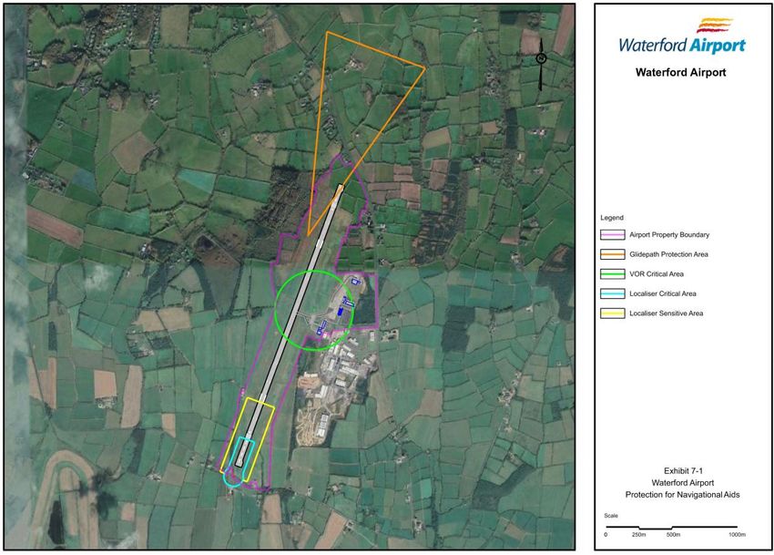
Waterford Regional Airport & Business Park Masterplan
A new runway expansion programme identified by the Airport Board has the potential to meet the
regional air travel demand by delivering the appropriate infrastructure to accommodate larger
aircraft types that can deliver competitive offerings and opportunities to the people and businesses
of the southeast.
The Council recognises the strategic importance of Waterford Airport to the future development
of Waterford and the wider City Region, its central role in increasing the critical mass of Waterford
City, and the improvement to the overall connectivity of the South East Region.
1.2 Policy Context
National Aviation Policy2 states that “Ireland recognises the important role that regional airports
play in their areas and in regional development” and sets out a number of actions which are
intended to support regional airports, including Waterford Regional Airport.
The National Planning Framework (NPF) recognises regional airports as “key infrastructure for
national and regional development”. Waterford Regional Airport is recognised in the NPF as a key
strategic regional and national asset where it states that “Waterford and the wider south-east region
is served by a regional airport and the Port of Waterford at Belview and Rosslare-Europort, which
are geographically close to EU trading partners and will be important in Ireland’s response to
Brexit”.
The Southern Regional Assembly’s Regional Spatial and Economic Strategy (RSES) states at section
6 that the return of scheduled passenger services to Waterford Airport and associated investment in
Infrastructure is one of the key elements in making the Waterford Metropolitan Area a successful
enterprising Economic Engine Driving Metropolitan and Regional Enterprise Growth.
The RSES goes on to state at section 6.3 that:
Waterford Airport is a key piece of strategic infrastructure for the Waterford MASP and
Gateway for the wider South-East Area
Investment in a runway extension would enhance the international connectivity of Waterford
for Business (including the large multi-national companies involved in export trade), support
the development of TUSE Research and Development with international partners and
provide for increased tourist traffic.
4
Waterford Regional Airport & Business Park Masterplan
The runway extension of 500m sought by the Airport Authority would provide for the
accommodation of up to 1,700 flights per annum including larger Boeing 737 and Airbus
A320 aircraft.
In addition, Waterford MASP Policy Objective 13 states that:
It is an objective to support the further development of Waterford Airport and, in particular, the
development of:
an extension of the existing runway to accommodate larger aircraft;
improved transport linkages and services between the airport, Waterford City and the entire
South-East Region, i.e. roads and public transport;
measures to encourage additional operators offering services from this location;
the expansion and development of aviation related industries at the airport.
In this regard, Development Plans should incorporate policies to protect longer-term flight path
public safety zones and to control uses which could adversely impact on the airport’s operations or
the potential for new runway development and extensions sufficient to handle larger aircraft.
Local Authorities should ensure that consideration of airport-related infrastructure and facilities is
informed by an adequate level of environmental assessment including assessment of potential impacts
on designated European Sites.
Furthermore, Waterford MASP Policy Objective 15 states that:
It is an objective to support investment in infrastructure, including increased capacity of road, rail,
ports and Waterford Airport to maximise the potential of tourism subject to the outcome of
environmental assessments and the planning process.
The Waterford Planning, Land Use and Transportation Strategy (PLUTS) views the Airport as a
regional asset which has the capacity to provide direct air links between the South East and major
airline hubs in the UK and Europe. The strategy sees the diversification of the role of the Airport
as a key facilitator to its future success.
1.3 Airport and Business Park Development
Waterford Airport opened in December 1981 with a 1,200 metre runway that could accommodate
single and twin-engine light aircraft. The Airport has a runway that is 1,433 metres long and 30
metres wide, and is classed as a Code 2 facility in terms of the International Civil Aviation
5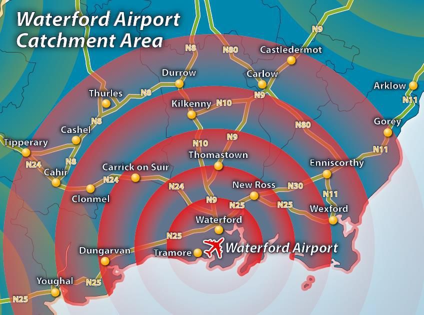
Waterford Regional Airport & Business Park                                              Masterplan

Organisation (ICAO) Annex 14 standards. There are 2 aprons at the Airport, one serving the Sea
Air Rescue Facility and one adjacent to the Terminal building. There are 200 car parking spaces
directly adjacent to the Terminal building.

The genesis of the Business Park was due to its location adjacent to the Airport. It was proposed
to channel development into the Park which would benefit from the close proximity of the airport.
To acknowledge existing development, the area was zoned for commercial use in the 2005 County
Development Plan.

The Business Park area has since been increased with a number of permissions granted in the last
Plan period. The total area of the Business Park is 138.6 hectares. To date, a variety of uses have
been permitted within the park. Given the strategic context of the Airport and associated Business
Park, there is a need to ensure the strategic and appropriate focus of the type of development
which is permitted into this area.

1. 4    Infrastructure

1.4.1   Wastewater

There is no public sewerage scheme in the area, and wastewater is treated on site. Stormwater is
attenuated and disposed of by the developers.

1.4.2   Water

The Airport and Business Park is served by the East Waterford Water Supply. It is considered
that there is sufficient capacity to serve the development of the area. For emergency requirements,
a supply of water is drained from the public supply over a 2 week period and is stored on site.
This gradual extraction from the public water supply is necessary to ensure sufficient capacity or
pressure to supply the Airport or Business Park in the event of an emergency.

1.4.3   Energy Supply

The ESB operates a 20kv power line along the route of the R875 & R685 and along part of the
R708 adjacent to the site. There is also a 38kv network line running from Tramore to
Butlerstown. The proximity of 3 no. 100kv stations at Butlerstown, Killoteran and Waterford
suggests a reasonably reliable electricity supply to the industrial lands.

                                                   6
Waterford Regional Airport & Business Park Masterplan
1.4.4 Road Network
The Airport and Business Park is served by the R708, which connects the R685
Tramore/Dunmore Road to the south to the Waterford Ring Road to the north. They are located
9km from Waterford City and Bellview Port and 5km from Tramore. Rosslare Port and Cork
Port are located 85km and 137km away, respectively.
There are currently no public transport links to the Airport or Business Park.
1.5 Constraints on Development
Maps 1-5 provide details on the control zones surrounding the Airport. It is the policy of the
Council to protect the Airport and surrounding lands from inhibiting or non-compatible
development. To this end, the development of lands in the vicinity of the Airport for light
industrial/commercial development must be mindful of its location adjacent to the Airport so as
not to obstruct the safe and effective operation of the Airport function. The restrictions set out in the
attached Maps will apply to any applications for development within the Airport Control Zones.
To further enhance the safety of residents in the area, the Council supports the establishment of
Public Safety Zones at Waterford Airport.
1.6 Development Strategy
1.6.1 Waterford Regional Airport
The Council supports the development objectives of Waterford Regional Airport plc for the
future development of the airport which are to:
Increase the competitiveness of the South East Region and promote the balanced
development of the Region in accordance with the National Spatial Strategy;
Promote the accessibility and attractiveness of the Region for both business and
inbound tourism;
Improve transport infrastructure for South East Region; and
Provide and promote cargo facilities to support industry and inward investment in the
Region.
7
Waterford Regional Airport & Business Park                                                 Masterplan

To achieve the policy objectives set out above, Waterford City and County Council, in partnership
with Waterford Regional Airport PLC, have proposed the development of an extension to, and
widening of, the existing runway at Waterford Regional Airport along with associated works
including widening of the taxiway, extension to the car parking area, re-alignment of security fencing,
new navigation lighting, underground holding tank, demolition of two existing houses to the north of
the runway and alterations to site drainage.

The proposed development would comprise the following principal elements:
a) Extension of the existing 1,433 metre long runway by 491 metres at its northern end and 363 at its
southern end, resulting in a total runway length of 2,287metres;
b) Widening of the existing and extended runway from 30 metres in width to 45 metres in width;
c) Widening of the existing taxiway connecting the runway to the Airport Apron from 15 metres in
width to 23 metres in width;
d) New landing lights to the north of the R708 at Keiloge;
e) Associated alterations to runway lighting, drainage and runway shoulders;
f) Demolition of two detached houses fronting onto the R708 at Ballygarran, at the northern end of
the extended runway;
g) Construction of a new 205 space car park to the east of the existing car park, in front of the
terminal building; and
h) All associated, drainage, landscaping and site works.

An application for the above has been submitted to An Bord Pleanála, and a decision is awaited in
respect of the proposal. All future development works will be designed to ensure full compliance
with both the Irish Aviation Authority and international aviation safety standards. .

As the Airport develops and there is a subsequent increase in demand for surface transport
facilities, the Council in conjunction with Waterford Regional Airport plc will liaise with bus
operators to develop a public transport link between Waterford City and the Airport and Business
Park.

Policies relating specifically to the Airport are included within the main Development Plan, such as
in Chapter 4 (Economy, Education and Retail).

1.6.2   Business Park

The Airport Business Park offers an opportunity to facilitate not only airport-dependent

                                                  8
Waterford Regional Airport & Business Park Masterplan
enterprises, but also the types of those which can offer long-term prospects for generating revenues
in new technologies and knowledge based areas, such as Information and Communications
Technology, Medical Devices, Biotechnology, Pharmaceuticals, the Green Economy and
Renewable Energy. There is also a need to continue to focus on channeling airport-related
industries, and those with specific locational requirements to be close to the Airport, into the
Business Park.
Activities which would cause atmospheric obscuration, attract bird concentrations, or cause other
nuisance or hazards so as to obstruct the safe and effective operation of the Airport function shall
be excluded from locating within the Business Park. The Council will encourage the development
of businesses which engage in activities that are complementary to the role of the Airport.
1.6.3 Zoning
To allow for the future expansion of both the Airport and Business Park, these have been zoned for
Airport (GZT N1.3), and Light Industry, Enterprise & Employment (GZT C2.1) – refer to
Development Management Standards Zoning Matrix.
Figure 1 – Zoning
9Waterford Regional Airport & Business Park Masterplan
1.7 Development Management
1.7.1 Design, Layout and Materials
All future development works at the Airport and Business Park shall be in compliance with
Appendix 1 - Airport Control Zone – Explanatory Notes for Development Control in the Vicinity of
Waterford Airport and the Development Standards set out in Volume 2 (Development Management
Standards) of the City and County Development Plan. In the application of this guidance material,
the more stringent requirementwill always apply.
1.7.2 Noise
Noise is a concern for persons living under flight paths or in close proximity to the Airport. Air
noise refers to noise from aircraft in flight or on the runway during take-off or after landing.
Ground noise is other types of noise generated at the Airport such as the ground running of
aircraft engines. To minimise both air and ground noise associated with the Airport, future
planning applications should address Airport noise mitigation measures.
1.7.3 Natural Heritage
The Tramore Dunes and Back Strand are located approximately 1.2km to the south of the Airport
and Business Park. This area is designated as a Special Area of Conservation (SAC), a Special
Protection Area (SPA) and is also a proposed Natural Heritage Area (pNHA). In assessing both
Airport and Business Park development proposals the Planning Authority will have due regard to
any potential adverse impacts such proposals may have on this area.
An Appropriate Assessment will be carried out at project level to ensure that there is no negative
impact on the integrity (defined by the structure and function and conservation objectives) of the
Natura 2000 site at Tramore Dunes and Backstrand and that the requirements of Articles 6 (3) and
(4) of the EU Habitats Directive 92/43/EEC are fully satisfied.
1.7.4 Landscaping
Landscaping is a particularly important issue for Waterford Airport and Business Park due to the
exposed and elevated nature of the area. Future development proposals at the Airport and
10Waterford Regional Airport & Business Park Masterplan
Business Park shall be required to prepare landscape management plans that reduce the visual
impact of development on the landscape. For reasons of aviation safety, deterring birds from the
airfield is an important landscaping consideration.
1.7.5 Referrals of Planning Applications
Applications in the vicinity of the Airport will be referred to the Irish Aviation Authority for
comment to ensure that proposed development does not have adverse technical or other
implications for the safety and/or normal operation of the Airport.
11Waterford Regional Airport & Business Park Masterplan
APPENDIX 1: AIRPORT CONTROL ZONES
The purpose of this document is to provide the Council and the public, information to ensure
that the lands surrounding the airport can be protected through the application of development
and land use controls, so that the operation and future development of Waterford Airport can
be safeguarded. This document defines the required land use protection for lands adjacent to
and surrounding the airport in terms of protection against erection of obstacles that are
hazardous to aviation, the presence of features and activities that have a negative effect upon
propagation of radio frequency emissions from air navigation aids which are necessary for
safe and accurate navigation in the airspace of Waterford Airport, and guide proper land uses
for lands potentially subject to aircraft noise.
1.0 LAND PROTECTION FROM AIRCRAFT NOISE IMPACT
1.1 Aircraft Noise & Land Use Impacts
To protect the public from the adverse effects of aircraft noise, it is important to control
development of certain land uses within those lands that potentially would be subject to
various levels of aircraft noise. This will protect the community by ensuring that no new land
uses are permitted that could cause disturbance to residents and users of those lands.
Contours of expected levels of aircraft noise have been developed and provide an illustration
of the extent and location of areas that are potentially affected by specific aircraft noise levels.
The noise contours are developed on the basis of forecasted aircraft movements at the airport
for a peak period of operation using an internationally recognised Integrated Noise Model
(INM).
The premise for land use zoning within the aircraft noise lands is that certain human activities
can be permitted to exist, and to be developed further, where the predicted future level of
aircraft noise would not cause serious noise disturbance, or result in adverse effects on the
health of those living or working in areas subject to aircraft noise emissions.
Areas in which serious noise disturbance or mental health effects might be predicted to arise
as a result of aircraft noise, would be classed as restricted, or even prohibited, from further
development for human activities.
The following table, Table 1-1, lists the typical land uses permitted within areas affected by
specific noise levels and should be read in conjunction with Map 1.
12Waterford Regional Airport & Business Park Masterplan
Table 1 -1: Typical Land Uses Permitted within Specific Noise Contour Levels
Aircraft Noise Contour Permitted Uses and Development
< 57 dBA Residential
Outdoor Recreational Facilities
Commercial
Public Facilities
Municipal Utilities
Industrial
Transportation
Agriculture
57-63 dBA Limited Outdoor Recreation Facilities
Commercial
Limited Public Facilities
Municipal Utilities
Industrial
Transportation
Agriculture
63-69 dBA Limited Outdoor Recreation Facilities
Commercial
Municipal Utilities
Industrial
Transportation
Agriculture
> 69 dBA Limited Outdoor Recreation Facilities
Limited Commercial
Municipal Utilities
Industrial
Transportation
Agriculture
Guidance on aircraft noise and land uses within lands around an airport that prevail in the UK
specifies that development should not occur in a noise contour band where predicted noise
levels could be greater than 72 dBA. Noise modelling carried out for Waterford Airport,
based on forecasted air traffic levels, suggests that this level of aircraft noise emission would
be unlikely to affect any of the lands outside the airport, and would be confined to the
immediate area of/ surrounding the runway.
13Waterford Regional Airport & Business Park Masterplan
2.0 OBSTACLE LIMITATION SURFACES PROTECTION
2.1 Definition of Protected Obstacle Limitation Surfaces
Ireland has adopted the Standards and Recommended Practices of the International Civil
Aviation Organization (ICAO) to control the existence and erection of obstacles to aviation
that might endanger aircraft in flight. Under regulations established for this purpose, all public
airports are to be safeguarded against erection of obstacles in accordance with Obstacle
Limitation Surfaces (OLS) that restrict or prohibit obstacles around an airport, and especially
within the safety- critical areas off the ends of the runway that serve to protect the runway
approach and take- off operations.
The OLS are imaginary planes that define the maximum allowable height of obstacles within
the approach and take-off areas of the runway (Approach and Take-Off Surfaces), along the
sides of a runway strip (Transitional Surfaces), and for a distance around the airport (Inner
Horizontal and Conical Surfaces). No obstacles are permitted to penetrate these surfaces
unless a valid safety case can be made ensuring that aircraft will not be in danger should an
obstacle protrude through the OLS.
The OLS specifications reflect the code of the runway, whether the runway has instrument
guidance for approach and landing, and whether that guidance is provided in the vertical
plane or not. In the case of Waterford Airport, the ultimate runway is classed as an ICAO
Code 4 Runway with a precision instrument approach. The OLS referred to in this section as
necessary for the protection of Waterford Airport are also illustrated in Map 2.
2.2 Instrument Approach and Missed Approach Protection
In addition to the established OLS surfaces and the obstacle protection required for them, the
instrument approach procedures in place at an airport also have a need for protection against
the effects of obstacles on flight operations. The airport must apply the ICAO Annex 14 OLS for
the purposes of airport licensing and certification, and apply the ILS protection surfaces on top
of these in order to protect the integrity of the ILS instrument approach for the runway(s) at
Waterford Airport.
14Waterford Regional Airport & Business Park Masterplan
2.3 Obstacle Limitation Surface Protection
In the following section the required obstacle protection areas at and around Waterford
Airport, and the limitations to be applied on the maximum height of obstacles existing or
erected within these areas, are defined.
It should be noted that while the OLS establish the maximum elevation to which an obstacle
may be erected within the various OLS areas, this does not mean that it is always safe to erect
obstacles to the maximum permitted elevation, or to erect any obstacles. A proliferation of
obstacles, even when fully compliant with the OLS, would be undesirable in the vicinity of an
airport. Where an application is made to erect an obstacle within one of the protected OLS
areas, reference will be made to the Irish Aviation Authority so that an aeronautical
assessment may be made of the effect that such an obstacle may have on the safety of flight
operations at the airport.
Map 2 illustrates the location and extent of the required obstacle limitation surfaces, within
which assessment and control of obstacles is required under the applicable aviation
regulations.
2.3.1 Sections 1 & 2 (Inner Horizontal Surface)
Within this zone the following are not permitted:
1. Buildings or structures exceeding the maximum height of the Inner Horizontal
surface;
2. Facilities that may attract wildlife, especially birds, due to the proximity of low altitude
aircraft operations
NOTE: No building or structure exceeding 25m in height should be erected within this area
without consultation with the airport.
2.3.2 Sections 3 & 4 (Conical Surface)
Within this zone the following are not permitted:
1. Building or structures that exceed the allowable maximum elevation at a specified point in
the conical surface as defined in Section 2.0.
15Waterford Regional Airport & Business Park Masterplan
2. Facilities that may attract wildlife, especially birds, due to the proximity of low altitude
aircraft operations.
NOTE: No building or structure exceeding 40m in height should be erected within this area
without consultation with the airport.
2.3.3 Sections 5 & 6 (Approach & Take-Off Surfaces – Sloping Sections)
Within this zone the following are not permitted:
1 Building or structures that exceed the maximum allowable elevation at a specified point
within the approach or take-off surfaces as defined in Section 2.0;
2 Facilities that may attract wildlife, especially birds, due to the proximity of low altitude
aircraft operations;
3 Buildings and structures constructed in compliance with the obstacle limitations of these
surfaces may still pose a hazard to aircraft operations and all planning applications for
buildings within the airport approach and take-off areas should be assessed in
consultation with the airport.
4 Facilities that would increase the severity of an aircraft incident or accident, even though
these facilities do not in themselves pose a safety hazard to aircraft operations. For
example, sporting complexes that would accommodate large numbers of visitors should
not be located within an approach or take-off area, even if the height of the structure is
not in violation of the OLS.
NOTE: Noise contours and their associated uses should also be consulted when assessing land
use for lands lying within Sections 5 and 6.
2.3.4 Sections 7 & 8 (Approach & Take-Off Surfaces – Horizontal Section)
Within this zone the following are not permitted:
1 Building or structures that exceed the elevation of the horizontal section of the approach
surface.
2 Buildings or structure exceeding 15m in height should not be erected within this area
without consultation with the airport.
3 Buildings and structures that may affect visibility or operations but which are constructed
adjacent to but outside these areas may still pose a hazard to aircraft operations. Any
16Waterford Regional Airport & Business Park Masterplan
application for planning permission for lands on the edges of, but immediately adjacent
to, the approach and take-off areas should be referred to the airport for consideration as to
their potential impact on flight safety.
4 Facilities that may attract wildlife, especially birds, due to the proximity of low altitude
aircraft operations should not be permitted.
2.3.5 Sections 9 & 10 (Transitional surfaces)
Within this zone the following are not permitted:
1 Buildings or structures that exceed the permitted elevation of the transitional surfaces
should not be permitted in these areas;
2 Buildings or structures that exceed 25m in height should not be erected beneath a runway
transitional surface;
3 Facilities that may attract wildlife, especially birds, due to the proximity of low altitude
aircraft operations should not be permitted within an area restricted by a runway
transitional surface
2.3.6 Sections 11 & 12 (ILS Transitional Surfaces)
Within this zone the following are not permitted:
1. Buildings or structures that exceed the permitted elevation of the ILS transitional surfaces.
2.3.7 Sections 13 & 14 (ILS Missed Approach Surface)
Within this zone the following are not permitted:
1 Buildings or structures in a location that results in their top elevation exceeding the
permitted obstacle limitation surface for the ILS Missed Approach operation.
3.0 PUBLIC SAFETY ZONES
Public Safety Zones (PSZs) are areas beyond the ends of airport runways in which some form
of land use control is deemed to be necessary in order to protect the public against the
accident risk arising from overflying aircraft failing to remain airborne and impacting inside
the high risk areas off the ends of a runway. The zones themselves are defined by contours of
17Waterford Regional Airport & Business Park Masterplan
individual risk and are created by computer modelling to map individual third party risk
exposure for the nature and level of aircraft operations forecast for any particular runway, as
well as the frequency of crash accidents and their consequences. Land uses within the Public
Safety Zones are required by law to be controlled by planning authorities.
The shape of the PSZ is reflective of an “inverted triangle” due to the method in which risk is
calculated and mapped. The base of the triangle is located along the runway threshold and
represents a larger area of land due to the greater risk of an accident closer to the end of a
runway. The tip, or apex, of the triangle is located farthest from the runway and represents the
least amount of land protection due to the lower level of accident risk arising in this area.
Map 3 displays the PSZ contours applied for Waterford Airport.
The Public Safety Zones developed for Waterford Airport do not have any major
development located within the two risk contour bands. The land beyond the ends of the
runway is mostly used for agricultural purposes with sporadic dwellings and farm structures.
As the implementation of the Public Safety Zones are not retro-active, existing dwellings are
permitted to remain within the PSZ.
4.0 PROTECTION FOR NAVIGATIONAL AIDS
Waterford Airport currently has an instrument approach system that comprises an Instrument
Landing System (ILS) localizer and glidepath installation. The electromagnetic energy
broadcast from the localiser and glidepath installations is susceptible to interference from
electrical discharge and presence of large metallic objects in close proximity to the antennae.
As these instruments are used for navigational guidance in critical phases of flight, the
environment surrounding the antennae structures must be protected from electromagnetic
interference.
The following guidelines are provided for protection of navigational aids.
4.1 Instrument Landing System
4.1.1 ILS Localiser
The ILS localiser requires a safeguarded area that comprises 2 parts, with the following
characteristics and restrictions:
18Waterford Regional Airport & Business Park Masterplan
Part A: Within a circle 75m radius centred on the localizer array
- No objects higher than 1.2m;
Part B: Within a rectangle 365m x 610m centred on the localizer array
- No metallic objects higher than 1.2m
- No objects higher than 2.5m
4.1.2 Glidepath Antenna
The ideal safeguarding for the glidepath antenna is a triangular shaped area commencing at
the antenna array, extending out to a distance of 1500m towards the landing aircraft, and
diverging at 150 from the origin. The area should be free of all metallic objects, power lines,
telephone lines, and roads. However, this may not always be achievable and, as a result, a
minimum clear distance of 600m is stipulated in front of the glidepath antenna.
4.1.3 VHF Omni-directional Range
The VOR will require an object-free area of 300m radius centred on the VOR. This area
cannot include any natural or man-made objects. However, any existing object that cannot be
relocated outside this radius will require study to ensure that the object does not cause
electromagnetic interference or obscures the VOR transmission in critical directions used for
air navigation.
Map 4 illustrates the protected flight zones for Navigational Aids for Waterford Airport.
5.0 Establishment of Laser Protected Flight Zones
Laser protected flight zones are established around an airport in accordance with ICAO
Annex 14 to mitigate the effect of laser operations on low flying aircraft.
There are three zones located around the airport:
Laser-Beam Free Flight Zone (LFFZ): Laser irradiance level to not exceed
50nW/cm2
Laser-Beam Critical Flight Zone (LCFZ): Laser irradiance level to not exceed
5µW/cm2
Laser-Beam Sensitive Flight Zone (LSFZ): Laser irradiance level to not exceed
100µW/cm2
19Waterford Regional Airport & Business Park Masterplan
Map 5 illustrates the Laser Bean Protection Areas for Waterford Airport.
The dimensions vary depending on the type of zone. Both the LFFZ and the LCFZ have
defined dimensions stated in the aviation safety regulations, however the LSFZ is determined
based on the area surrounding the airport.
Laser operations may be conducted within these areas so long as the irradiance of the laser
does not exceed the stated value for the flight zone. Notification to the airport and the IAA of
laser operations may also be required. The airport may be required to issue a NOTAM should
it be deemed that laser operations may affect critical areas of flight, regardless of the laser
irradiance level.
20Waterford Regional Airport & Business Park Masterplan
Map 1Waterford Regional Airport & Business Park Masterplan
Map 2Waterford Regional Airport & Business Park Masterplan
Map 3Waterford Regional Airport & Business Park Masterplan
Map 4Waterford Regional Airport & Business Park Masterplan
Map 5You can also read