West Schofields Frequently asked questions - Department of Planning and Environment
←
→
Page content transcription
If your browser does not render page correctly, please read the page content below
West Schofields
Frequently asked questions
August 2018
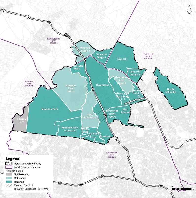
Where is West Schofields?
• West Schofields is in the Blacktown local government area, in the North West Growth Area. The precinct
is bordered by Garfield Road to the north, Railway Terrace and Eastern Creek to the east, Towson Road
and Stonecutter’s Ridge Golf Course to the south, and Bells Creek to the west. It is approximately 5km
from Schofields town centre. A map of the North West Growth Area, which shows West Schofields’
location, is available below:
Department of Planning and Environment
Page 1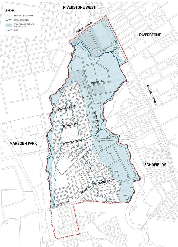
West Schofields
    Frequently asked questions

                                                                                                             August 2018

What does the draft masterplan do?

•    The draft West Schofields masterplan will guide the precinct’s creation from the ground up. It forms the
     basis of a draft zoning plan which will allow for growth of the precinct.
•    The masterplan has been developed by the Department of Planning and Environment in collaboration
     with Blacktown City Council and in consultation with Roads and Maritime Services, Transport for NSW, the
     Department of Education, Sydney Water, the Office of Environment and Heritage, and other government
     agencies to make sure the precinct has the services and infrastructure it needs to support a new
     community.

What does the draft masterplan propose?

•    The draft masterplan maps out new land uses in the precinct, including new areas for homes to support
     Sydney’s growing population. It also identifies key infrastructure needed, including:
         •   A local centre
         •   New cycleways and footpaths
         •   Road upgrades
         •   Parks and playing fields
•    The masterplan also examines the precinct’s context and plans for environmental and heritage
     conservation.

How will West Schofields be serviced by transport?

•    Residents will be able to access the Sydney Metro Northwest at Tallawong Station, due to open in 2019.
     The existing Schofields and Riverstone train stations are also nearby.
•    The masterplan allows for footpaths and on and off-road cycleways to encourage a healthy and well-
     connected community.
•    In addition, drivers will be able to access the precinct via Garfield Road, which is due to be widened and
     upgraded, the future Towson Road/Burdekin Road extension (known as Burdekin Link Road) and
     Schofields Road which is currently being upgraded and widened.

                                                                    Department of Planning and Environment
                                                                                                                  Page 2
West Schofields
Frequently asked questions
August 2018
What employment opportunities will there be near the precinct?
• West Schofields will have easy access to jobs in nearby Marsden Park and Marsden Park Industrial
precincts and the Rouse Hill town centre. It is also only 10 minutes by train from Schofields Station to
Blacktown Station.
What community facilities and open space will be available?
• The masterplan proposes more than 108 hectares of new open space including 12 double playing fields
and several local parks. These facilities will support the residents of the greater North West Growth Area
and future residents of West Schofields.
• The masterplan provides the opportunity to create a Green Grid in the precinct. Combining the Green
Grid with pedestrian and cycle paths will improve connections within West Schofields and to its
neighbours.
• The masterplan allows for land for a potential primary school and, in the local centre, a community
facility.
What will be done to protect the environment?
• Proposed zoning and controls will protect existing native vegetation and the corridors of Bells and Eastern
Creeks.
• By protecting these creeks and areas rich in vegetation, as well as areas of Aboriginal and non-indigenous
heritage, the masterplan provides the opportunity to create a Green Grid in the precinct.
• The draft masterplan also creates the possibility of connecting Eastern Creek to the Western Sydney
Parklands in the south. This would further extend the Green Grid and support the Greater Sydney
Commission’s Central City District Plan.
How has flooding in the area been considered?
• West Schofields is subject to localised flooding from nearby creeks and waterways, as well as regional
flooding from the Hawkesbury–Nepean River. The draft masterplan ensures new houses will not be
located in high risk flood areas and evacuation routes will allow residents to leave the area safely in the
event of an emergency.
Department of Planning and Environment
Page 3West Schofields
Frequently asked questions
August 2018
• As part of the masterplanning process, a range of potential flood events were modelled. Modelling
identified the 1 in 100 chance per year flood level, and the Probable Maximum Flood (PMF) level. A map
showing the areas affected by these two levels is shown below.
• The masterplan will not allow any new homes to be built in the 1 in 100 chance per year flood area. The
number of homes within the PMF area has been capped at 2000 to ensure safe evacuation. These
measures were determined in consultation with the Hawkesbury-Nepean Flood Management Directorate.
• The masterplan and supporting development controls will include building and design controls to increase
the resilience of homes in extreme flood events, allowing easier recovery.
Department of Planning and Environment
Page 4West Schofields
Frequently asked questions
August 2018
How will the precinct be serviced?
• Water, wastewater and electricity will be delivered by the relevant authority (such as Sydney Water and
Endeavour Energy) or the developer, depending on the situation. Existing services will need to be
extended, and some new services will be required to support all new homes in the precinct.
• Water: New water mains will need to be extended from the existing system to service the
precinct. A new main is proposed to be built along Schofields Road by the end of 2019.
• Wastewater: Significant infrastructure is required to fully service West Schofields. The southern
part of the precinct will likely be serviced first.
• Electricity: Electricity will come from the Schofields zone substation, which has capacity to service
up to 500 homes in the region before needing to be upgraded with new feeders. The first new
homes in West Schofields will likely be able to use this. New feeders will be required from the
Schofields zone substation by 2021 to fully support the new precinct.
How will local infrastructure be provided?
• Blacktown City Council will be responsible for preparing a contributions plan to fund necessary local
infrastructure such as open space, local roads and drainage works. Council has been a partner in the
development of the draft masterplan.
How will regional infrastructure be provided?
• West Schofields falls within an area where Special Infrastructure Contributions (SIC) are collected to fund
regional infrastructure. SIC funding supports the delivery of infrastructure such as:
• State and regional roads
• Transport facilities including bus shelters and interchanges
• Regional open space, footpaths and cycleways
• Social infrastructure such as schools, healthcare and emergency services.
• Special infrastructure contributions are paid by anyone developing and delivering residential dwellings
within a Special Contribution Area, and anyone subdividing land. This means that in the West Schofields
precinct, infrastructure will be developed alongside new homes, to support the community as it grows.
Department of Planning and Environment
Page 5West Schofields
Frequently asked questions
August 2018
What consultation has there been with the public?
• The Department held landowner information sessions in April and May 2016 and newsletters were
released in August 2016 and May 2017. The Department also wrote to all landowners in August 2017
regarding the Transport Corridor.
• The exhibition period is an important time for consultation. The community will be able to view the
proposed plans and reports and provide feedback by making a submission. Submissions can be made until
28 September 2018.
• The Department will consider all submissions and make necessary improvements to the precinct plan
before any rezoning decisions are made.
How can I have my say?
• The draft masterplan will be on exhibition for four weeks from Friday 31 August to Friday 28 September
2018 for community review and feedback.
• Help shape the future character of West Schofields by:
• Viewing the draft masterplan documents until 28 September 2018
• Online: at West Schofields draft masterplan
• Making a submission during the exhibition period. A formal submission allows you to provide
feedback and ideas which address specific points in the draft masterplan. Your submission will be
published but you may request that your name and address are not displayed on the
Department’s website or alongside your submission.
• Meeting the project team to ask your questions in person at one of our drop-in sessions:
o Wednesday 12 September 4pm – 7pm
o Saturday 15 September 10am – 1pm
o Both drop-in sessions will be held at: Riverstone Schofields Memorial Club- 23 Market
Street, Riverstone NSW 2756.
Who in the community is invited to give feedback?
• Feedback is welcomed from anyone, from West Schofields landowners and residents, to anyone in the
broader community.
Department of Planning and Environment
Page 6West Schofields
Frequently asked questions
August 2018
What are the next steps?
• Following the exhibition period, submissions will be reviewed and any required amendments
incorporated into the final masterplan.
• Subsequently the Department may make a recommendation to the Minister for Planning to rezone the
precinct and then Blacktown City Council will become the consent authority.
Where can I find out more?
• Call on 1300 305 695.
• If English isn’t your first language, please call 131 450. Ask for an interpreter in your language and then
request to be connected to our Information Centre on 1300 305 695.
• Email info@planning.nsw.gov.au
Department of Planning and Environment
Page 7You can also read