What Gullies Mean: Georgia's "Little Grand Canyon" and Southern Environmental History
←
→
Page content transcription
If your browser does not render page correctly, please read the page content below
What Gullies Mean: Georgia's "Little
     Grand Canyon" and Southern
         Environmental History
                                 By PAUL S . SUTTER

O N rrssuRFACE—WHAT LITTLE OF IT IS LEFT—PROVIDENCE CANYON
State Park could well be the nation's most ironic conservation area. The
Georgia State Parks and Historic Sites department describes Providence
Canyon—also known as Georgia's ""Little Grand Canyon"—as a place
where visitors are "amazed" by the breathtaking colors of the canyon
walls; "the pink, orange, red and purple hues of the soft canyon soil," the
description continues, "make a beautiful natural painting at this unique
park." Anyone who has visited would be hard-pressed not to agree; to
the eye, it is a spectacular place, reminiscent of the badlands and canyon
country of the American West. One might even call it sublime. Indeed,
Providence Canyon fits the aesthetic conventions that have guided park
making in the United States for the last century and a half. Calling it
Georgia's "Little Grand Canyon" is a gesture in that direction. But—
and here the irony seeps in, destabilizing things—Providence Canyon
is a decidedly human artifact. The park's website admits that its gaping
chasms (some would call them gullies), which reach 150 feet deep and
several hundred yards wide in places, were "caused by poor farming
practices during the 1800s," and the visitor center's introductory video
calls the canyon "a spectacular testimony to man and his mistakes."' So

    'Providence Canyon State Park. Georgia State Parks and Historic Sites. http://www
.gastateparks.org/providence/. I would like to thank ihe participants of the Poner L. Foniine Jr.
History Symposium at the University of Mississippi, whefL" 1firstpresented this paper. Writing this
essay required a crash course inlhc soil sciences, and ¡appreciate the guidance of Todd Rasmussen,
David Leigh. Rhett Jackson, and Daniel Markewit/.of the University of Georgia; Frank Magilligan
of Dartmouth College; and James Hyatt of Eastern Connecticut State University. Mac Moye. Sam
Singer. Bobby Williams, and Joy Joyner shared their local knowledge of Stewart County's land-
scape and history. I have presented this materia) to and received importanl feedback from audi-
ences at the University of Kansas. Maciilester College, the "Living with Wilderness" symposium
sponsored by the Adirondack Museum, the University of Houston, Clenison University. MIT. the
University of North Carolina at Chapel Hilt, and Western Carolina University. My graduate stu-
dents in southern environmental history, past and present, as well as Bill Cronon, Neil Maher.
Man Stewart, and Don Worster. provided important commentary and encouragement. Finally, the

MR. SUTTER is an       associate professor of history at the University of Colorado
at Boulder.
THE JOURNAL OF SOUTHPRN HISTORY
Volume LXXVi, No. 3, August 2010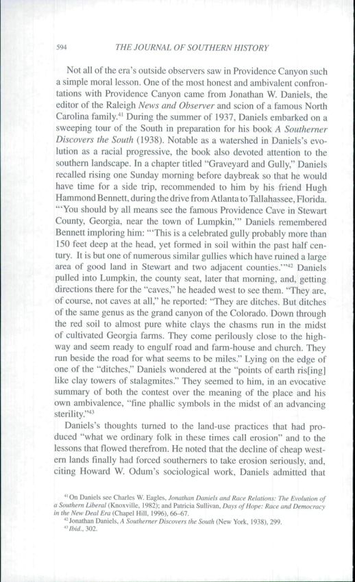
580                 THE JOURNAL OF SOUTHERN HISTORY

what does it mean to preserve a place that is the product of what its own
custodians suggest were poor land-use practices? What does it mean to
celebrate the beauty of an environmental disaster?
    It is difficult to get past the irony of Providence Canyon: the incon-
gruity of, even the humor in, the granting of park status to a network
of massive erosion gullies. But the more one meditates on this system
of gullies and learns about its history, the more one realizes that focus-
ing on irony does the place a disservice. There is something deeper
here, and irony is too facile an analytical tool to plumb it. Indeed,
the logic behind any assessment of Providence Canyon as ironic pre-
sumes a strict policing of the boundaries between nature and culture
that does not match the history of the place. What is refreshing about
Providence Canyon as an interpretive opportunity is not merely the rev-
elation that this preserved natural area is the product of human agency;
Providence Canyon is so obviously not a wilderness landscape that
using its history to trouble environmentalist assumptions about pristine
nature is too easy an exercise. Rather, the interpretive opportunity here
flows in the other direction, from culture back to nature. What tums
out to be so interesting about Providence Canyon is just how natural
it is.
   Providence Canyon also seems at first blush to be a particularly
southem place, exemplary not only of the region's distinctive and dra-
matic history of human-induced soil erosion but also of its renowned
New South boosterism. Leave it to southemers to tum a scar into a
point of pride. But, as with irony, arguments for regional distinctive-
ness can only go so far. One can fathom a great deal about southem
environmental history by staring into Providence Canyon's multihued
abyss, and a substantial portion of this essay will be devoted to making
that point—and to documenting the history of others who did the same.
But Providence Canyon can also impart local and extraregional lessons
that challenge the adequacy of arguments for regional distinctiveness.
Providence Canyon's meaning cannot be easily contained within the
region, and that is an important lesson for environmental historians as
they pay more attention to the South.
   As quite a few scholars have plaintively pointed out. southem environ-
mental history has been slow to develop.- While the South's landscapes.

anonymous readers for the Journal of Southem History, in the wisdom of their comments, forced
me to make this a better essay.
    ^See. for example. Otis L. Graham. "Again the Backward Region? Environmental History
in and of the American South." Southern Cultures. 6 (Summer 20()()), 50-72; Mart A. Stewart,
"Southem Environmental History." in John B. Boles, ed.. A Companion to the American South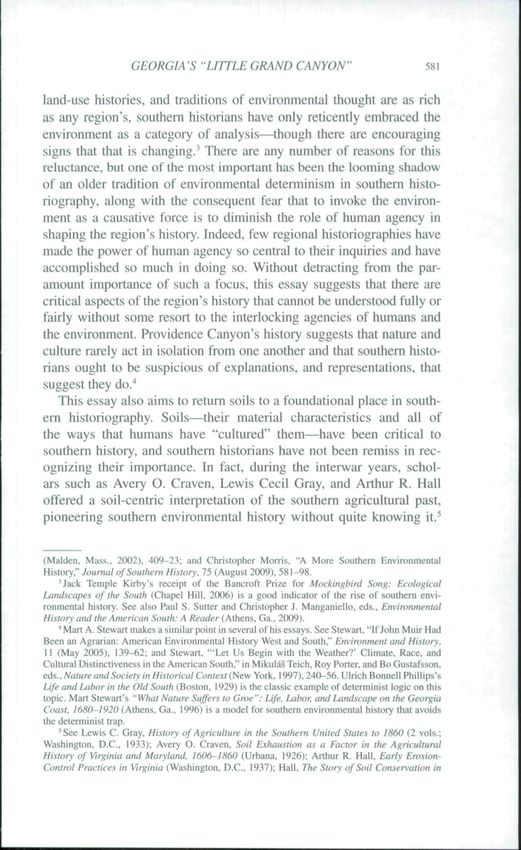
GEORGIA'S "LITTLEGRAND CANYON"                                           581

land-use histories, and traditions of environmental thought are as rich
as any region's, southern historians have only reticently embraced tbe
environment as a category of analysis^though there are encouraging
signs that that is changing.^ There are any number of reasons for this
reluctance, but one of the most important has been the looming shadow
of an older tradition of environmental determinism in southern histo-
riography, along with the consequent fear that to invoke the environ-
ment as a causative foree is to diminish the role of human agency in
shaping the region's history. Indeed, few regional historiographies have
made the power of human agency so central to their inquiries and bave
accomplished so much in doing so. Without detracting from the par-
amount importance of such a focus, this essay suggests that there are
critical aspects of the region's history that cannot be understood fully or
fairly without some resort to the interlocking agencies of humans and
the environment. Providence Canyon's history suggests that nature and
culture rarely act in isolation from one another and that southern histo-
rians ought to be suspicious of explanations, and representations, that
suggest they do."*
   This essay also aims to return soils to a foundational place in south-
em historiography. Soils—tbeir material characteristics and all of
the ways that humans have "cultured" them—have been critical to
southern history, and southern historians have not been remiss in rec-
ognizing their importance. In fact, during the interwar years, schol-
ars such as Avery O. Craven, Lewis Cecil Gray, and Arthur R. Hall
offered a soil-centric interpretation of the southern agricultural past,
pioneering southern environmental history without quite knowing it.^

(Maiden. Mass.. 2002). 409-23; and Christopher Morris, "A More Southern Environmental
History." Journal of Southern Hi.ttory\ 75 (August 2009), 581-98.
     'Jack Temple Kirby"s receipt of the Bancroft Prize for Mockingbird Song: Ecological
Landscapes of the South (Chapel Hill. 2006) is a goad indicator of the rise of southern envi-
ronmental hisiory. See also Paul S, Sutter and Christopher J. Mangaiiiello. eds.. Environmental
Histoiy and the American South: A Reader (P\.\hfas. Ga.. 2009).
    "•Mart A. Stewart makes a similar point in several of his essays. SeeStewart. "If John Muir Had
Been an Agrarian: American Environmental History West and South." Environment and History,
11 (May 2005). 139-62: and Stewart. -Let Us Begin with the Weather?' Climaie. Race, and
Cultural Distinctiveness in the American South." in Mikulás Teich, Roy Porter, and Bo Gustafsson.
ed,s.. Nature and Society in Historical Conte.xt (New York. 1997), 240-56. Ulrich Bonnell Phillips's
Life and Labor in the Old South (Boston. 1929) is the classic example of deierminist logic on this
topic. Mart Stewart's "Wliat Nature Suffers to Groe": Life. Labor, and Landscape on the Georgia
Coast. ¡6H(^I')2O (Athens. Gü.. 1996) is a model for southern environmental history that avoids
I he detcmiiiiist trap.
     ^See Lewis C. Gray. History of Agriculture in the Southern United States to I860 (2 vols.;
Washington. D.C.. 1933); Avery O. Craven. Soil Exhaustion as a Factor in the Agricultural
Hi.story of Virginia and Maryland. 1606-1860 (Urbana. 1926): Arthur R. Hall. Early Erosion-
Control Practices in Virginia (Washington. D.C., 1937); Hail, The Story of Soil Con.sen'ation in
582                  THE JOURNAL OF SOUTHERN HISTORY

More recently, a number of agricultural and environmental historians
have returned our attention to a tradition of agricultural reform that made
soil culture central to antebellum southern politics.^ But, strikingly, nei-
ther environmental nor southern historians have yet tackled the history
of massive soil erosion in the tobacco and cotton South, a history that
coincided with wrenching social and racial transformations in southern
society. This essay cannot hope to provide such a history, but it does
suggest that Providence Canyon is a fruitful spot to delineate a research
agenda.                                                       i     |
   Beyond contending with southern environmental history and the
importance of soils within it, a focus on Providence Canyon also
allows an exploration of the power of environmental representation
and its place in southem history. This essay both chans and challenges
the history of Providence Canyon's visual and literary objectification
and the ways in which Americans have pictured one of the central sto-
ries of American environmental history—the massive translocation of
soils that accompanied the centuries-long spread of staple-crop agri-
culture across the American South. The history of Providence Canyon
suggests just how influential visual representation has been in con-
structing the South as a coherent region with a distinctively destruc-
tive environmental history, but the story of these gullies also stands
as a cautionary tale about using a single place to represent a larger
problem.
   Today, few Americans, few Georgians even, have heard of Providence
Canyon or the state park that contains it. But during the 1930s, as
Americans became both acutely soil conscious and eager to conserve

the South Carolina Piedtnont. 1800-1860 (Washington, D.C., 1940); and Hall. "Soil Erosion and
Agriculture in the Southern Piedmont: A History" (Ph.D. dis.sertation. Duke Univensity. 1948).
For a discussion of ihis cohort, see Lynn A. Nelson. Pharsalia: An Environtnental Biography of a
Southem Plantation. 1780-llim {Athens. Ga.. 2001). 1-28.
    "See Sleven Stoll. Larding the Lean Earth: Soil and Society in Nineteenth-Century America
(New York. 2002): Carville Earle. "The Myth of the Soiilhern Soil Miner: Macrohistory.
Agricultural Innovation, and Rnvironmenial Change," in Donald Worster, ed.. The Ends of the
Earth: Perspectives on Modern Envirotimentul History (New York, 1988). 175-210; Jack Temple
Kirby. Poquosin: A Study of Rural Latidscape and Society (Chapel Hill, 1995): Edmund Ruffin.
Nature's Management: Writing.y on Landscape and Reform. ¡822-1859, edited by Jack Temple
Kirby (Alhens, Ga., 20(K)): Nelson, Pharsalia: and Benjamin R, Cohen. Notes from the Ground:
Science. Soil, and Society in the American Countryside (New Haven. 2009). Several scholars have
tackled the subject quickly but more broadly. See Albert E. Cowdrey, This Ijind. This South: An
Environmental History (rev. ed.: Lexington. Ky.. 1996): Stanley W, Trimble. "Perspectives on
the History of Soil Erosion Control in the Eastern United States." Agricultural History. 59 (April
1985), 162-80: Douglas Helms, "Soil and Southem History." ihid, 74 (Aulumn 200()), 723-58;
Ted Steinberg. Down to Earth: Nature's Role in American History (New Yt)rk. 2(H)2); and Martin
Melosi. "Environmeni," in Melosi, ed.. The New Encyclopedia of Southem Culture. Vol. VIH:
Environment (Chapel Hill. 2007). 1-20. esp. 5-7, 12-14.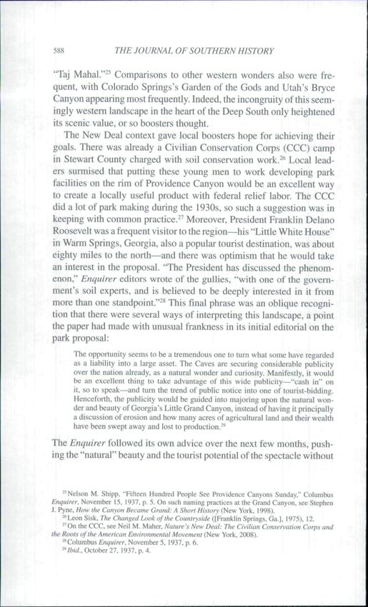
GEORGIA 'S "LITTLE GRAND CANYON"                                    583

parklands. Providence Canyon enjoyed a modicum of fame. The first
part of this article maps the contours of that fame as it developed in
a fascinating interpretive contest between, on one hand, local and
regional boosters who praised Providence Canyon as a spectacular nat-
ural wonder worthy of park status and, on the other, national soil con-
servationists and reformers who made Providence Canyon stand for the
destructiveness of southern agriculture. The second part of the article
takes up where these two competing visions left off by entering into and
reviving this history of interpretation and by offering a set of lessons—
some familiar to southern historians but others novel—that Providence
Canyon might teach us today.
    Providence Canyon State Park sits at the geographical center of the
cotton plantation South, on the cusp of several major physiographical
regions. Located in Stewart County, in the west-central part of Georgia,
the network of canyons that makes up the park—the park actually con-
tains sixteen "canyons"—covers approximately eleven hundred acres,
but a large part of the county and parts of several adjoining counties
are riddled with similar, if less notable, gullies.' In the eariy 1970s, a
graduate student at Florida State University, using satellite photos and
the knowledge of local residents, found 159 substantial steep-sided gul-
lies in Stewart County alone.** Stewart County abuts the Chattahoochee
River on the county's western side, rising through a series of natural
terraces to an upland plain almost seven hundred feet above sea level at
its highest point. Physiographically, Providence Canyon is a part of the
upper coastal plain; it is situated about twenty miles below the coastal
plain's border with the southwestern comer of the piedmont plateau,
the southem province best known for its history of human-induced soil
erosion. More ,specifically. Providence Canyon lies within a transitional
district known as the Fall Line Hills." Just across the Chattahoochee
River from Stewart County is Alabama and the beginning of the black
belt, a crescent of alkaline and once-fertile prairie soils that sweeps
northwestward for several hundred miles. Settlers rapidly converted
these black belt prairies to cotton fields in the several decades before

    ' Sigrid Sanders, "Providence Canyon." online in The New Georgia Encyclopedia, http://www
.georj;iaencyclopedia.org/nge/Article.jsp?id=h-943.
    "Robert W. McVety. "Steep-Sided Gully Erosion in Stewart County, Geof^gia: Causes and
Consequences" (M.S. thesis. Florida State University, 1971). 6-7.
    "William Z. Clark Jr. and Amold C. Zisa, Physiographic Map of Georgia (Atlanta, 1976),
reprinted in Georgia Wildlife Federation, The Fire Forest: Longleaf Pine-Wiregrass Ecosystem
(Conyers.Ga.. 2001), 8-9.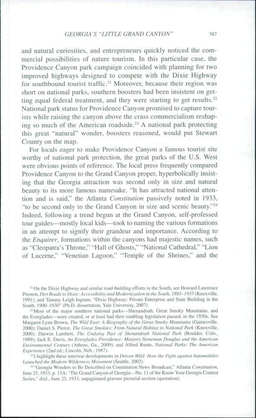
584 THE JOURNAL OF SOUTHERN HISTORY
the Civil War, transforming the region into one of the richest sectors of
the plantation South.'"
The gullies of Stewart County were the product of the county's fron-
tier settlement, and they yawned ever wider as cotton took hold of the
region. Stewart County was Creek territory until the 1820s, when the
Creeks ceded it to the United States. Settlement proceeded quickly
thereafter. By 1850, roughly 60 percent of the county was "improved"
land." Early settlers tended to focus their energies on tbe clay hills sec-
tion of the county, which was in a mixed forest of oak, hickory, and
pine before agricultural clearance. They bypassed the level longleaf
pine lands in the eastern part of the county on the assumption that the
soils that underlay pine forests were less fertile.'- Those pine-covered
lands were also farther from the Chattahoochee River. The steep gullies
that became Providence Canyon began to form soon after white set-
tlers and black slaves arrived, and some were well formed by tbe Civil
War. In 1859 a local congregation had to move its house of worship
across a road to prevent the structure from sliding into an expanding
chasm; several other buildings and those buried in the church grave-
yard were not so lucky. The gullies of Stewart County continued to
expand in the half century after the Civil War, until they covered tens
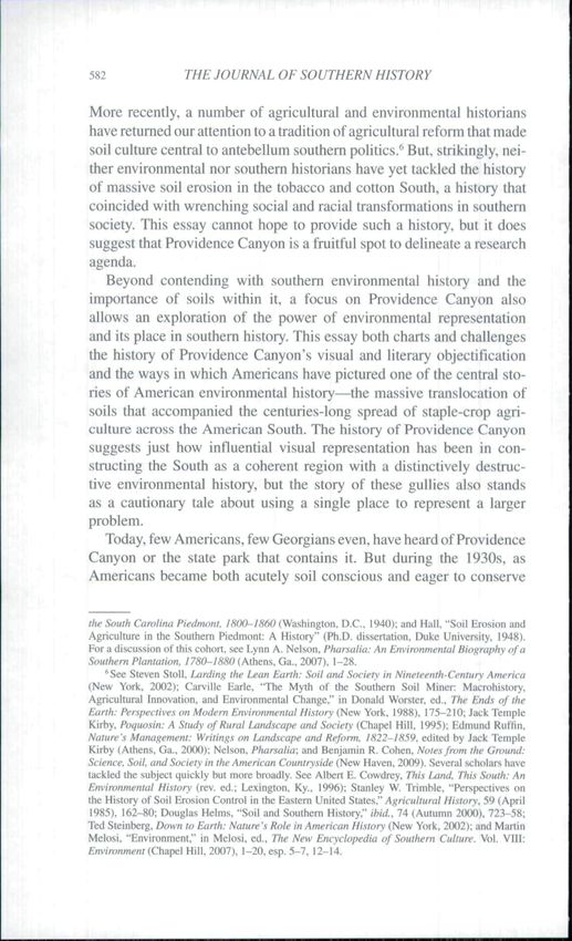
of thousands of acres by the early twentieth century. (See Figure I for
an image from 1893.) Cotton production peaked in Stewart County
around 1890. declined slightly over the next two decades, and then fell
fairly precipitously after 1910. The gullies, however, kept growing.
By the 1930s, they may have been at the height^or depth—of their
development.'-'
What has Providence Canyon meant to those who have observed it
develop over its century-and-a-half history? It is hard to know how locals
reacted as the gullies deepened during the nineteenth century, though
Providence Canyon's name—derived from Providence Methodist
Church, which teetered on the rim—suggests what was likely the
'"Helen Eliza Terrill. History of Stewart County. Georgia. Vol. 1 (Columbus. Ga.. 1958). 3-Í:
David D. Long et at., Soil Survey of Stewart County, Georgia (Washington, D.C., 1915). 5-7.
"Francis J. Magilligan and Melissa L. Stamp. "Historical Land-Cover Changes and
Hydrogeomorphic Adjustment in a Small Georgia Watershed." Annals of the American Association
of Geographers, 87 (December 1997), 614-35. esp. 615-18; Matthew M. Moye, "Stewait County,"
in The New Geoi^ia Encyclopedia, http://www.georgiaencyclopedia.org/nge/Article.jsp'.'id=
h-2392&hl=y.
'^Long etal.. Soil Survey of Stewart County. 7. 10.
" Magilligan and Stamp. "Historical Land-Cover Changes and Hydrogeomorphic Adjustment,"
esp. 618; Long et al.. Soil Survey of Stewart Coun¡y, 10. See also Terrill, History of Stewart County,
I, 385-86.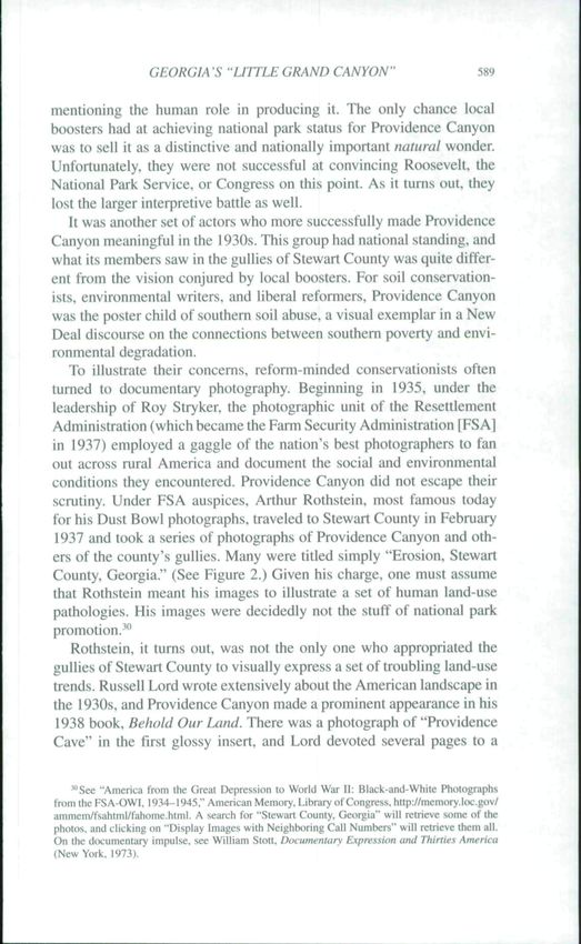
GEORGIAS "LITTLE GRAND CANYON'                                          585

Figure 1. Providence Caves, Stewart County, Georgia, 1893. Vanishing Georgia.
Georgia Division of Archives and History. Office of Secretary of State.

dominant interpretation of canyon formation: it was an act of God.'^ It
may not have seemed a providential one. but there is little evidence that
settlers saw poor land management as a cause. Land was abundant and
cheap and cultural roots were shallow, so there was likely little impetus
for soil conservation as familand began washing and caving downward
toward the Chattahoochee. Geological and soil surveyors did take note
of Providence Canyon in the late nineteenth and early twentieth centu-
ries as a curiosity and stratigraphie revelation, but it was not until the
 1930s, with cotton in decline, that Providence Canyon began to take on
two competing sets of meanings that together defined the irony of its
current park status.'^
   Locally, the 1930s saw the first sustained efforts to make the network
of gullies into a park. Providence Canyon started seeing a large number

           \. History of Stewart County.\, 174-75.
    ''Long et al.. Soil Sun'ey of Stewart County; Geoige Little. Catalogue of Ores, Rocks and
Woods, Selected from the Geological Surxey Collection of the State of Georgia. U.S.A.... (Atlanta.
 1878), 14; Otto Veaich and Lloyd William Stephenson. Preliminary Report on the Geology of
the Coastal Plain of Georgia (Atlanta. 1911). 29-30; Ted Steinberg, Acts of God: The Unnatural
History of Natural Disasters (New York, 2000), xxi.
586                 THE JOURNAL OF SOUTHERN HISTORY

of visitors during that decade, when the Columbus Enquirer began a
campaign to have it designated a national park. By the late 1930s, the
most extreme of the gullies were already known as "Georgia's Little
Grand Canyon" or, alternately, the "Royal Gorge of the Chattahoochee
Valley," a disingenuous moniker since the Chattaboochee River had
nothing to do with carving them.'^ But accuracy was less important
than publicity, and the Enquirer did its best to whip some up. The
Enquirer launched its campaign to make what locals called "Providence
Caves"—as in cave-in, not cavern—into a national park in October
 1937. and the paper premised its attempt on the conviction that the can-
yons were natural formations. In their opening editorial on the sub-
ject, the editors praised the canyons as "one of the true show places in
mother nature's garden of the earth," and a few days later they waxed,
"When Nature scooped out the acres now missing from the spot and
washed them from the location, she had a definite eye for beauty."'^
The Lumpkin Lions Club called the area an "unusual and awesome
natural wonder of great scenic beauty" in a resolution of support for
the park idea.'** The editors of the Richland Srewart-Web.sfer Journal
were no less insistent in their editorializing: "The hand of Nature has
been both artisan and artist in going about the creation of this allur-
ing spot," they wrote of what they called a "charming creation of
Nature."'''
   A second major theme of the local campaign was the desire to
"swell the tourist erop," an impulse shared by the many eivic leaders
who supported the proposed park. This emphasis on bow important
a park designation would be to capturing tourist dollars was ubiqui-
tous and unabashed at a time when the county's agricultural fortunes
were melting away with its soil and subsoil. Providence Canyon, the
Enquirer noted in a succinct summary of its editorial position, was
"a land that Nature built for tourists."-" Such sentiment was char-
acteristic of the interwar era, a period of intense park boosterism,
when local governments, commercial and eivic organizations, and
other interests (such as newspapermen) eagerly proposed national
parks in their areas so as to attract government and tourist dollars.
The automobile increased the market viability of roadside attractions

    '"Terrill, History of.Stewart County. I. 385.
    "Columbus (Ga.jfflçMiVpr. October 27, \9M.p.4: ibid.. November 2. 1937. p. 6.
    "*"Lumpkin Lions Club Passes Resolutions Urging Park at 'Little Grand Canyon,'" Richland
(Gi.) Stewart-Webster Journal. November 4. 1937, p. I.
    ""Strong Support for Canyon Park." ibid.. November 18. 1937. p. 2-
    -"Columbus Enquirer. November 2. 1937, p. 6.
GEORGIA'S "LITTLE GRAND CANYON"                                          587

and natural curiosities, and entrepreneurs quickly noticed the com-
mercial possibilities of nature tourism. In this particular case, the
Providence Canyon park campaign coincided with planning for two
improved highways designed to compete with the Dixie Highway
for southbound tourist traffic.^' Moreover, because their region was
short on national parks, southern boosters had been insistent on get-
ting equal federal treatment, and they were starting to get results.^^
National park status for Providence Canyon promised to capture tour-
ists while raising the canyon above the crass commercialism reshap-
ing so much of the American roadside.^' A national park protecting
this great "natural" wonder, boosters reasoned, would put Stewart
County on the map.
   For locals eager to make Providence Canyon a famous tourist site
worthy of national park protection, the great parks of the U.S. West
were obvious points of reference. The local press frequently compared
Providence Canyon to the Grand Canyon proper, hyperbolically insist-
ing that the Georgia attraction was second only in size and natural
beauty to its more famous namesake. "It has attracted national atten-
tion and is said," the Atlanta Constitution passively noted in 1933,
"to be second only to the Grand Canyon in size and scenic beauty."-"
Indeed, following a trend begun at the Grand Canyon, self-profes.sed
tour guides—mostly local kids—took to naming the various formations
in an attempt to signify their grandeur and importance. According to
the Enquirer, formations within the canyons had majestic names, such
as "Cleopatra's Throne," "Hall of Ghosts," "National Cathedral," "Lion
of Lucerne," "Venetian Lagoon," "Temple of the Shrines," and the

     ' On the Dixie Highway and similar road-building efforts in the South, see Howard Lawrence
       n, Dirt Roads to Dixie: Accessibility and Modernization in the South. /Si{.5-/9,?5(Knoxville,
 1991): and Tammy Leigh Ingram. "Dixie Highway: Private Enterprise and State Building in the
South. 1900-1930" (Ph.D. dissertation, Yale University. 2007).
    '^Most of the major southern national parks—Shenandoah. Great Smoky Mountains, and
the Everglades—were created, or at leasi had their enabling legislation passed, in the I93()s. See
Margaret Lynn Brown. The Wild East: A Biography of the Great Smoky Mountains (Gainesville.
2(XX)): Daniel S. Pierce. The Great Smokies: From Natural Habitat to National Park (Knoxvilíe.
2(KH}): Darwin Lambert, The Utidying Past of Shenandoah National Park (Boulder, Colo..
 1989): Jack E. Davis, An Everglades Providence: Marjory Stoneman Douglas and the American
Environmental Century (Athens. Ga,. 2009); and Alfred Runte. National Parks: The American
Experience (2nd ed.; Lincoln. Neb.. 1987).
    -' 1 highlight these interwar developments in Driven Wild: How the Fight against Automobiles
Launched the Modem Wilderness Movement (Seattle. 2002).
    •^ "Georgia Wonders to Be Described on Constitution News Broadcast," Atlanta Constitution,
June 2.5. 1933. p. I3A: "The Grand Canyon ofGeorgia—No. II of the Know Your Georgia Contest
Series." ihid., June 25, 1933, unpaginated gravure pictorial section (quotation).
588                 THE JOURNAL OF SOUTHERN HISTORY

"Taj Mahal."^ Comparisons to other westem wonders also were fre-
quent, with Colorado Springs's Garden of the Gods and Utah's Bryce
Canyon appearing most frequently. Indeed, the incongniity of this seem-
ingly westem landscape in the heart of the Deep South only heightened
its scenic value, or so boosters thought.
    The New Deal context gave local boosters hope for achieving their
goals. There was already a Civilian Conservation Corps (CCC) camp
in Stewart County charged with soil conservation work.^^ Local lead-
ers surmised that putting these young men to work developing park
facilities on the rim of Providence Canyon would be an excellent way
to create a locally useful product with federal relief labor. The CCC
did a lot of park making during the 193ÜS, so such a suggestion was in
keeping with common practice.-'' Moreover, President Franklin Delano
Roosevelt was a frequent visitor to the region—his "Little White House"
in Warm Springs, Georgia, also a popular tourist destination, was about
eighty miles to the north—and there was optimism that he would take
an interest in the proposal. "The President has discussed the phenom-
enon," Enquirer editors wrote of the gullies, "with one of the govem-
ment's soil experts, and is believed to be deeply interested in it from
more than one standpoint."-^ This final phrase was an oblique recogni-
tion that there were several ways of interpreting this landscape, a point
the paper had made with unusual frankness in its initial editorial on the
park proposal:

       The opportunity seems to be a tremendous one to tum what sotne have œgarded
       as a liability into a large asset. The Caves are securing considerable publicity
       over the nation already, as a natural wonder and curiosity. Manifestly, it would
       be an excellent tbing lo take advantage of this wide publicity—"cash in" on
       it, so to speak—and turn the trend of public notice into one of tourist-bidding.
       Henceforth, the publicity v^íould be guided into majoring upon the natural won-
       der and beauty of Georgia's Little Grand Canyon, instead of having it principally
       a discussion of erosion and how many acres of agriculiural land and their wealth
       have been swept away and lost to production.-^

The Enquirer followed its own advice over the next few months, push-
ing the "natural" beauty and the tourist potential of the spectacle without

    "Nelson M. Shipp, "Fifteen Hundred People See Providence Canyons Sunday," Columbus
Enquirer, November 15. 1937. p. 5. On such naming practices at the Grand Canyon, see Stephen
J. Pyne. How the Canyon Became Grand: A Short History (New York, 1998).
    ^*Leon Sisk. The Changed look of the Countryside ([Franklin Springs. Ga.]. 1975), 12.
    "On the CCC. see Neil M. Malier. Nature's New Deal: The Civilian Conserx'ation Corps and
the Roots of the American Environmental Movement (Nçw York. 21X18).
    '"Columbus Enquirer. November 5, 1937. p. 6.
    'VèiW., October 27. 1937. p. 4.
GEORGIA S ''UTTLE GRAND CANYON" 589
mentioning the human role in producing it. The only chance local
boosters had at achieving national park status for Providence Canyon
was to sell it as a distinctive and nationally important natural wonder.
Unfortunately, they were not successful at convincing Roosevelt, the
National Park Service, or Congress on this point. As it turns out, they
lost the larger interpretive battle as well.
It was another set of actors who more successfully made Providence
Canyon meaningful in the 1930s. This group had national standing, and
what Its members saw in the gullies of Stewart County was quite differ-
ent from the vision conjured by local boosters. For soil conservation-
ists, environmental writers, and liberal reformers. Providence Canyon
was the poster child of southern soil abuse, a visual exemplar in a New
Deal discourse on the connections between southern poverty and envi-
ronmental degradation.
To illustrate their concerns, reform-minded conservationists often
turned to documentary photography. Beginning in 1935, under the
leadership of Roy Stryker, the photographic unit of the Resettlement
Administration {which became the Farm Security Administration [FSAl
in 1937) employed a gaggle of the nation's best photographers to fan
out across rural America and document the social and environmental
conditions they encountered. Providence Canyon did not escape their
scrutiny. Under FSA auspices, Arthur Rothstein, most famous today
for his Dust Bowl photographs, traveled to Stewart County in February
1937 and took a series of photographs of Providence Canyon and oth-
ers of the county's gullies. Many were titled simply "Erosion, Stewart
County, Georgia." (See Figure 2.) Given his charge, one must assume
that Rothstein meant his images to illustrate a set of human land-use
pathologies. His images were decidedly not the stuff of national park
promotion."'
Rothstein, it turns out, was not the only one who appropriated the
gullies of Stewart County to visually express a set of troubling land-use
trends. Russell Lord wrote extensively about the American landscape in
the 1930s, and Providence Canyon made a prominent appearance in his
1938 book. Behold Our Land. There was a photograph of "Providence
Cave" in the first glossy insert, and Lord devoted several pages to a
"'See "America from the Great Depression to World War II: Black and White Photographs
from the FSA-OWI. 1934-1945." American Memory. Library of Congress. http://memory.l(K.gov/
ammem/fsahiml/fahome.html. A search for "Stewart County. Georgia" will retrieve some of the
photos, and clicking on "Display Images wilh Neighboring Call Numbers" will retrieve them all.
On ihe d(x;umentary impulse, see William Stott. Documentary Expression and Thirties America
(New York. 1973)..J... .
590 THE JOURNAL OF SOUTHERN HISTORY
Figure 2. Erosion, Stewart County, Georgia. Arthur Rothstcin photograph of
Providence Canyon, 1937. Library of Congress, http://hdl.loc,gov/loc.pnp/fsa,8b35823.
discussion of the county's gullies. He began with a sturdy piece of can-
yon lore: that Providence Canyon started as a result of a dripping bam
roof. This creation story raises some interesting questions about the
relationship between human land use and gully formation, but Lord,
who was more intent on describing the voraciousness with which the
gullies had been swallowing the county's farmland, largely dismissed
it. Instead, he quoted from 1935 congressional testimony of Hugh
Hammond Bennett, head of the Soil Conservation Service (SCS), in
which Bennett noted that "70.000 acres formerly cultivated" in Stewart
County had been "reduced to largely worthless gullied land." "Some of
the gullies," Bennett continued, "are the deepest I have ever seen. The
largest of them, locally known as Providence Cave, is eight miles west
of Lumpkin, Georgia."^' Providence Canyon was an agricultural cancer.
Lord insisted, metastasizing unopposed.
^' Russell Lord, Behold Our Land (Boston. 1938), 169 (quotations), photograph in insert after
p. 48. Providence Canyon also made an appearance in Lord's To Hold This Soil (Washington. D.C.,
1938). 49-50.GEORGIAS "LITTLE GRAND CANYON" 591
Although soil and politics had mixed before in U.S. history, soil ero-
sion became perhaps the chief environmental concern of Americans in
the 193ÜS. evidenced in the many "soil jeremiads" of the era.-*- And the
towering figure in making soil matter to Americans during the inter-
war years was Bennett,, a North Carolina native who wrote prolifically
about the problem and was the key federal institution builder for soil
conservation. He rose through the ranks of the Bureau of Soils in the
U.S. Department of Agriculture (USDA) to become the first director of
the s e s . a signature New Deal conservation agency. Bennett's mag-
num opus is titled simply Soil Conservation (1939), and at almost a
thousand pages, it is an exhaustive treatment of the topic. But one only
has to make it to page four before the gullies of Stewart County make
their first appearance. The book's first figure is a photo of "virgin for-
ests," witb tbe aboriginal soil anchored and intact. The caption for the
subsequent, contrasting photo of Providence Canyon—a striking aer-
ial shot of cultivated land giving way to steep badlands—reads, "This
maze of gullies, which crosses an entire county in tbe Southern Coastal
Plain and cuts through portions of two adjoining counties, has perma-
nently destroyed more than a hundred thousand acres of some of the
best land in the locality."" (See Figure 3.) Like Lord and Rothstein,
Bennett saw the gullies of Stewart County as illustrative of the problem
he was doggedly trying to get Americans to take seriously. What better
way to shock them into action than to show the most extreme case. For
Bennett, that was Providence Canyon.^^
One of Bennett's main goals in publicizing soil erosion was to
get Americans to recognize the problem not as just a series of iso-
lated natural disasters but as a persistent and widespread scourge of
traditional agricultural land use. Soil erosion, he wrote, "is under-
stood now not as a freak of nature which occasionally turns up on iso-
lated farms and ranches but as an almost continually active process
which attacks countless fields, whole watersheds, and broad farming
'' I boTTOw the phrase "soil jeremiads" from Randall S. Beeman and James A. Pritchard, A
Green and Permanent ÍMnd: Ecology and Agriculture in the Twentieth Century (Lawrence, Kans..
2()01), II.
" Hugh Hammond Bennett, Soil Conservation (New York, 1939). 2 (first quotation). 4 (second
quotation).
''Bennett had been writing and testifying about the gullies of Stewart County for more
[han a decade. See. for instance. Bennett and W. R. Chapline, Soil Ercsion u National Menace
(Washington. D.C.. 1928); and Bennett. "Soil Loss Through Erosion Threatens Our Basic Asset,'"
New York 7ïmi*.ï. June 17, 1934, p. 3. And Providence Canyon continued to appeHr in his later writ-
ings. See Bennett and William Clayton Pryor. The Land We tiefend (New York, 1942). 46. 76; and
Bcnneit, Elements of Soil Conservation (New York. 1947), 10. 33.592 THE JOURNAL OF SOUTHERN HISTORY
Figuic 3. ¡ht^h flatiiinoiitJ Benneu, Soil Conservation (New York, 1939). 4.
communities."'^ Bennett admitted the extremity of the Stewart
County case later in his book, providing another photograph of the
gullies as well. "What has happened in Stewart County, Georgia,"
he wrote:
is a striking example of the extremes to which erosion can sometimes progress
when land is farmed without proper precautions. Approximately 7O.(X)O acres—
one-fourth of the land in this small county-—had been essentially ruined by gul-
lying and deep sheet erosion twenty-five years ago. Furthermore, some of the
gullies are without counterpart on the North American continent—huge, yawn-
ing chasms 1(X) feet or tnorc in depth . . . . One of the worst is Providence Cave,
which is said to have started with the drip from a bam roof some fifty years ago.
Already this enormous earth scar is said to have engulfed a schoolhouse, two
farm buildings, and much good farm land.^'' i i
I
Though extreme. Providence Canyon nonetheless stood as a striking
cautionary tale of what can happen when the soil is taken for granted.
Providence Canyon appeared in numerous other publications from
this era. There is a photograph of it in William R. Van Dersal's 1943
book. The American Land, which noted. "This chasm is almost 200
feet deep. It was caused by man and was started by unwise farm-
ing methods."" In Soil Erosion Control (1936), Austin Earle Burges
"Bennett, SoU Consen'ation, 56.
^''Ibid.. 61. Another image of "'Providence Cave" appears íTuí/.. 66.
"William R. Van Dorsal. The American Land: Its History atid Uses (New York. 1943), Plate
59 in Insert opposite p. 192.GEORGIA -S "LITTLE GRAND CANYON" 593
.Aplained that "Providence Gully" was "known to all students of soil
erosion for its immensity" and was "probably the deepest man-made
gully on the Westem Hemisphere."" In 1936 the British geographer
F. Grave Morris toured the Southeast in the company of the legendary
U.S. geographer Carl O. Sauer and a group of SCS officials to examine
the erosion problems of the region. Morris recalled seeing a number
of large gullies, but he focused in particular on Providence Canyon. A
"remarkable gully," he wrote, "occurs in the soils of the coastal plain
near Americus, Georgia, known locally as the 'Grand Canyon.' This
must now be more than half a mile in length and . . . it must be 150
to 200 feet in depth and perhaps 300 feet wide." "It is impossible to
do justice to the appalling results of soil erosion in the soulh-eastern
states," Morris continued. "An exploitive and wasteful system of agri-
culture has ruined the soil and this, in its tum, is reflected in the ter-
rible conditions under which the majority of the farmers, both white
and negro, are living."''' Providence Canyon also made a showing in the
second issue of Soil Conservation, the joumal of the SCS, in September
1935. Leon J. Sisk's article also attributed the canyon to a dripping bam
roof, but Sisk quickly moved into an imaginative realm, invoking the
farmer's bam as a symbol of the richness that had marked the coun-
ty's agricultural life prior to the disastrous erosion. Sisk assumed that
the bam (a .symbol of both careful animal husbandry and soil steward-
ship) must have been full of stored grain and hay for the farmer's live-
stock, and it surely echoed with the laughter of children. But then the
rains came, and the farmer neglected the rills and gullies that developed,
letting his prosperity and security wash away. As a narrative starting
point, this vision of settled abundance allowed Sisk to hammer home
the soil conservation gospel and its chief lesson: that we were tum-
ing good land to bad through our inattention. "|T]he largest gully in
Georgia," he concluded, "which has caused thousands of dollars dam-
aize. which would cost thousands more to stabilize, could have been
prevented .""*"
^"Austin Earie Buries, Soil Erosion Control: A Practical Exposition of the New Science of
Soil Conservation for Students. Farmers, and the General Public (Atlanta, 1936), 6-8 (quotations
on 6).
'•'F. Grave Morris. "Soil Erosion in South-Eastem United States," Geographical Joumal. 90
(October 1937), 363-70 (quotations on 368).
*'Leon J. Sisk, "All This Started from the Trickle from a Roof," 5Í>Í7 Conser\'ation, I (Sepleniber
1935). 12-13. For another example of this sort of moral lesson, see Saving Georgia Soils (Allanta,
1938). within which Providence Canyon had a prominent place. See ibid.. esp. 20. On bams and
their .symbolism, see Slolt. Lurding the txan Earth. 79-81.594 THE JOURNAL OF SOUTHERN HISTORY
Not all of the era's outside observers saw in Providence Canyon such
a simple moral lesson. One of the most honest and ambivalent confron-
tations with Providence Canyon came from Jonathan W. Daniels, the
editor of the Raleigh News and Observer and scion of a famous North
Carolina family."" During the summer of 1937, Daniels embarked on a
sweeping tour of the South in preparation for his book A Southerner
Discovers the South (1938). Notable as a watershed in Daniels's evo-
lution as a racial progressive, the book also devoted attention to the
southern landscape. In a chapter titled "Graveyard and Gully," Daniels
recalled rising one Sunday morning before daybreak so that he would
have time for a side trip, recommended to him by his friend Hugh
Hammond Bennett, during the drive from Atlanta to Tallahassee, Florida.
'"You should by all means see the famous Providence Cave in Stewart
County, Georgia, near the town of Lumpkin,'" Daniels remembered
Bennett imploring him: "This is a celebrated gully probably more than
150 feet deep at the head, yet formed in soil within the past half cen-
tury. It is but one of numerous similar gullies which have ruined a large
area of good land in Stewart and two adjacent counties.""*- Daniels
pulled Into Lumpkin, the county seat, later that morning, and, getting
directions there for the "caves," he headed west to see them. "They are,
of course, not caves at all," he reported; "They are ditches. But ditches
of the same genus as the grand canyon of the Colorado. Down through
the red soil to almost pure white clays the chasms run in the midst
of cultivated Georgia farms. They come perilously close to the high-
way and seem ready to engulf road and farm-house and church. They
run beside the road for what seems to be miles." Lying on the edge of
one of the "ditches," Daniels wondered at the "points of earth risling]
like clay towers of stalagmites." They seemed to him, in an evocative
summary of both the contest over the meaning of the place and his
own ambivalence, "fine phallic symbols in the midst of an advancing
Daniels's thoughts turned to the land-use practices that had pro-
duced "what we ordinary folk in these times call erosion" and to the
lessons that tlowed therefrom. He noted that the decline of cheap west-
em lands finally had forced southerners to take erosion seriously, and,
citing Howard W. Odum's sociological work, Daniels admitted that
" On Daniels see Charles W. Eagles, Jonathan Danieb and Race Relations: The Evolution of
a Southern Liberal (Knoxville. 1982); and Patricia Sullivan. Da\s of Hope: Race and Demovracv
in the New Deal Era (Chapel Hill. 1996). 66-67.
*= Jonathan Daniels. A Southerner Discovers the South (New York, 1938), 299.
''/bid., 302.GEORGIA 'S "LITTLE GRAND CANYON" 595
erosion and exhaustion were disproportionately southem problems—
a major lesson to be gleaned by any open-minded southerner touring
the region in the 1930s. But he also made an observation that Bennett's
description of the gullies had not prepared him for: "They left me not
so much shocked at land destroyed as puzzled by the character of the
destroying ditches." "The Stewart County ditches grew from careless
man and washing water." Daniels admitted: "But the land about them
did not seem to an unpracticed eye badly wom soils about to collapse
in dramatic canyoning. Instead the big ditches lay deep and open in the
midst of apparently rich and fertile fields. Corn, cotton and pecan trees
grow near them. And near them, too, I came upon a big bam smelling
pleasantly of animal husbandry. There were houses, too, surrounded by
such flowers as are generally grown in the country only by such folk
as love the earth as well as hope to profit from it." The gullies, in other
words, were dramatic, and it was hard not to see in them the region's
broader history of debilitating erosion. But there was also something
dissonant about the juxtaposition of apparently fine working lands and
deep gullies. As Daniels watched a crowd gather at Providence Canyon,
some coming by car and many more on foot, he concluded that "on that
Sunday afternoon that rived land did not look tragic; the people upon
it seemed not at all wa.sting survivors or wasted remnants of a human
order that had departed from depleted and eroded soil. Far otherwise,
land and people—white folk and Negroes—seemed to me that day vig-
orous and arrayed for pleasuring."^ As we will see, Daniels was on to
something when he wondered whether the gullies of Stewart County
were accurate representations of local land-use practices and attitudes
and whether they ought to stand for the environmental dimensions of
the benighted South.
Providence Canyon's most prominent appearance in the era's con-
servation literature came in Stuart Chase's 1936 classic, Rich Land,
Poor Land: A Study of Waste in the Natural Resources of America.
Chase was a popular writer and economic theorist who contended with
the social and environmental costs of waste, and he was one of many
interwar intellectuals enamored of planning as a means to achieve
social efficiency."**^ After focusing mostly on industrial and labor issues
"¡hid.. 302-5 {first quotation on 304-5; second, third, and fourth quotations on 302; fifth
qtiotation on 305). See also Howard W. Odum. Southern Regions of the United States (Chapel
Hill. 1936).
*' See Robert B. Westbrook. "Tribune of the Technostructure; The Popular Economics of Stuart
Chase." American Quarterly. 32 (Fall 1980). 387-408; and Siuari Chase. Rich Land, Poor Land:
A Study of Waste in the Natural Resources of America (New York, 1936).596 THE JOURNAL OE SOUTHERN HISTORY
through the 1920s and early 1930s, Chase turned his attention to natu-
ral resources and the costs of their profligate use. Rich Land, Poor Land
was the most prominent product of this interest, and to illustrate natu-
ral resource waste Chase chose as the book's feature image a photo-
graph of an erosion gully, which he placed opposite the title page as his
frontispiece. The photograph was captioned simply "Gulley in Stewart
County. Georgia."""'
Later in Rich Land, Poor Land—and in an excerpt from the book
published in Harper's Magazine under the title "When the Crop Lands
Go"—Chase took his readers to Stewart County for an extended tour.^^
•'When one becomes erosion conscious," Chase instructed, "a motor
trip through the country, especially west of the Alleghenies and south
of Washington, D.C., becomes an endless game of finding gullies. One
spots them as a beggar spots a coin." "In pursuit of this grim game,"
he continued, "I once followed gullies to their supreme exhibit in this
country—Stewart County, Georgia." Chase and his traveling compan-
ions came into the county from the east. After seeing a few of the coun-
ty's smaller specimens, they arrived at Providence Canyon, and Chase
was moved by what he saw:
road approached a kind of isthmus, perhaps lCX) yards wide. A plowed
field was oti the left and beyond it a sickening void. A battered church stood
on the right, a few pines about it. then another void. "Yes sir," said our guide.
"Here's the old he one, the one on the left. He started the whole system. And
do you know what started him? A trickle of water running off a fartner's bam
about forty years ago. Just one damn little trickle, and now a third of the county's
gone—forty thousand acres. Don't get too close to the edge. Sometimes she goes
in, an acre at a time.""*"
Although Chase's guide seemed to see the wasting away of the county
as a stroke of ill fortune. Chase was sickened by what he saw as a
profound example of wasted resources. Here was a supreme exhibit
indeed.
Chase was an agent of the New Deal—in fact, it was Chase from
whom Roosevelt cribbed the term—and Chase made it clear that his
visit to Stewart County was meant to advance the cause of New Deal
conservation.'^^ "Tens of millions of acres of American crop lands
are taking the same precipitous path," he warned, "and no virgin
*Chase. Rich Land, Poor Land.
" Stuart Chase, "When the Crop Lands Go," Hurper's Maga:.ine. 173 (August 1936). 225-33.
^^Chase, Rich Land. Poor Land. 92-94 (first and second quotations on 92; third and fotjrth
quotations on 93; fifth quotation on 94),
•«Stuart Chase, A New Deal (New York, 1932).GEORGIA S "LITTLE GRAND CANYON" 597
west remains." Here was the New Deal environmental critique in a
nutshell. "But all over the country groups of men like the conserva-
tion worker who drove us to Stewart County—lean, tanned men with
clever hands and keen eyes—have set to work lo check the landslide.
Many farmers are aiding them. But they cannot do it alone. There must
be more of them, and they must feel the force of public opinion behind
them."'"
Yet, despite toeing the New Deal party line. Chase was also taken
aback by Providence Canyon's beauty: "Only once before have I seen a
comparable phenomenon—the canyon of the Yellowstone in Wyoming.
That was geological erosion, and even grander; this was manmade,
but sufficiently superb." "The chasm," Chase admitted, "was awful
and beautiful." More to the point, though. Chase wondered whether
the chasm's development might be stopped or even healed, to which
his guide responded that it might be, if the runoff were diverted and
those areas that could be were planted in kudzu and black locust, the
era's favored botanical remedies for severe erosion. But it would be an
expensive effort, he suggested. "What ought to be done with them?"
Chase asked, searching for some local wisdom. "'Well, sir,'" his guide
responded, " T d have the govemment buy up the whole county and turn
it into a national park—with plenty of railings. You might even charge
admission. You don't see a sight like this often.'" Chase responded to
this suggestion with a muted expression of irony: "I looked into the
vivid, slipping horror. 'No,' I said. 'You don't.'"**'
In this encounter between local guide and national reformer, the
two interwar visions of what Providence Canyon meant collided. Like
most of his cohort. Chase had made the canyon stand for a particularly
southern variant on land abuse, though he was aware that its analogues
could be found in other regions—in the airborne topsoil of the Great
Plains, for instance, or the deepening arroyos of the Southwest. That
Providence Canyon was a horrible monument to human carelessness
and waste there was no doubt, and Chase hoped to use its exemplary
power to further the soil conservation cause. Nonetheless, Chase con-
ceded that there was something impressive there too, a beauty worth
seeing. But the problem with making it into a national park—the irony,
even—was precisely in the distinction Chase had made between geo-
logical and "manmade" erosion. National parks preserved the supreme
*Chase. Rich Land. Poor Land, 98-99 (quotations on 99).
^' Ibid.. 94-96 (first quotation on 94; second and third quotations on 95; fourth through seventh
quotations on 96).598 THE JOURNAL OF SOUTHERN HISTORY
examples of wondrous natural phenomena, and they kept the works
of humanity at bay, preserving a few remnant parts of the American
landscape where natural processes would not be disrupted by human
hands. Despite its visual appeal, then. Providence Canyon could
not pass as a national park because it was not natural. Or so Chase
thought.
Providence Canyon's interwar fame was fleeting. After Wodd War
II, the gullies of Stewart County faded from view, as did public con-
cem with soil erosion. The postwar exodus from the rural South and the
coming of machines, chemicals, and the other trappings of modem agri-
culture diminished the importance of soil culture and .severed the ties
that had connected the region's social and environmental problems in
the minds of interwar reformers. Meanwhile Worid War II and the cold
war rendered the New Deal agricultural critique increasingly unten-
able in an age of coerced consensus.^- Over the next several decades, as
the tenant system collapsed and the civil rights movement transformed
southem race relations, places such as Stewart County that were, or
had become, marginal for agriculture quietly reverted to forest, often
with govemment encouragement and subsidy. In 1971, after decades
of local pleas to state legislators. Providence Canyon became a state
park—a scenic spot that, while it does not shrink from its human past,
does not dwell on it either.**' As the conditions that produced the gullies
of Stewart County retreated from the southern landscape. Providence
Canyon again became a local curiosity. When a travel writer for the
Christian Science Monitor stumbled on Providence Canyon in 1954,
she was amazed how little known and undeveloped it was as a tourist
site.^
Providence Canyon deserves to be famous again. But for what?
How might we craft a new interpretation of the place that highlights
critical themes in southern environmental history? What should these
gullies mean? As a visual symbol for soil conservationists during the
1930s, Providence Canyon represented a particular environmental
narrative about southern agriculture, and it might still perform that
function today if visitors could look beyond their expectations that a
"On these developments, see Pete Daniel, Lost Revolutions: The South in the 1950s (Chapel
Hill. 2000); and Daniel, Toxic Drift: Pesticides and Health in the Post-World War II South (Baton
Rouge, 2005).
"Jacquelyn Cook. "Providence Canyon—Exciting Hole in the Ground," Georgia Magazine.
15(Noveniber 1971), 26-27.
''Bemice McCullar. 'Tour Guides Ignore Amazing Gully," Christian Science Monitor.
November 12, 1954, p. 10.You can also read