WINNIPEG: ASPIRATIONAL PLANNING, CHAOTIC DEVELOPMENT - by Christopher Leo University of Winnipeg
←
→
Page content transcription
If your browser does not render page correctly, please read the page content below
WINNIPEG:
ASPIRATIONAL
  PLANNING,
   CHAOTIC
DEVELOPMENT

          by
    Christopher Leo
 University of Winnipeg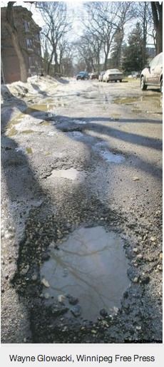
ABSTRACT
This paper looks at the politics of development in suburban and exurban
Winnipeg, showing how the reality of chaotic development is glossed over by
specious planning language. Drawing on case studies of two undeveloped or
newly-developing areas of the central city, Transcona West and Waverley West,
and a developing exurb, Springfield Municipality, the paper shows how municipal
infrastructure and services are extended widely and inefficiently across the region
in response to developers’ demands, and wishful thinking conceals the reality of
an unviable network. The city is left with infrastructure and municipal services
whose lack of viability becomes manifest in the city’s inability to maintain inner-
city streets and underground municipal services.

                                                                                 2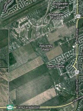
WINNIPEG:
          ASPIRATIONAL PLANNING, CHAOTIC
                   DEVELOPMENT
Introduction
Urban sprawl has long been a major preoccupation of the literature on North
American urban development. In that literature, a distressing amount of attention
has been devoted to definitional discussions, but in these pages, we will skirt that
terrain and proceed by diktat, defining sprawl as low-density, single-use
development: neighbourhoods or sections of cities marked by exclusivity, not only
of residential, commercial, industrial or agricultural land uses, but also of low,
medium and high densities, and light and heavy commercial and industrial
development. In the world of sprawl, these multiple exclusivities are further
multiplied by the definition of particular design types, residential wealth
gradations, and other specificities of land use.

Much of the literature on sprawl is critical of many of these varieties of exclusivity,
maintaining that they kill urbanity, choke off street life and mandate
environmentally harmful dependence on automobiles. Thomas Sieverts
intervenes in this long-running debate with an observation and a proposition. The
observation is that the definition of sprawl advanced here no longer describes an
important proportion of newer development. Instead, Sieverts describes current
built forms as taking the form of the Zwischenstadt, which is characterized by
“increasingly fractured... boundaries between urban fabric and open space and
nature; the gradual disappearance of the traditional hierarchical pattern; and the
mutual penetration of built forms and landscapes.” (Sieverts, 2003: x; Keil et alia,
2009; Young et al, 2010)

The observation contained in the word Zwischenstadt, therefore, is that what was
once a comprehensible cityscape, with both centre and periphery well defined,
and marked by a clear hierarchy of high-, medium- and low-density uses seems
gradually to be becoming a thing of the past. A clear contrast between city and
countryside is dissolving into an amorphous landscape of workplaces, residences
and places of business, connected by fast means of transportation, but
interspersed with the countryside in a way that is no longer clearly identifiable as
either urban or rural, and that lacks either an identifiable centre or a clear
hierarchy of central, intermediate and peripheral places.

In other words, sprawl’s fragmented, but still orderly arrangement of mutually
exclusive land uses has fragmented further, to the point where, in many places,
there is no longer such a thing as an identifiable city, despite the presence of
traditionally urban land uses. While such fragmentation and dispersal clashes

                                                                                     3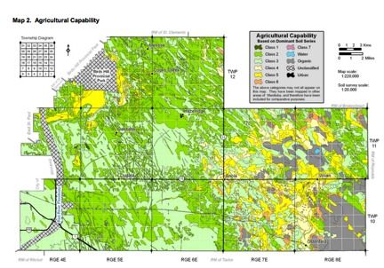
with a conventional planner’s idea of what constitutes an orderly distribution of
land uses, Sieverts sees nothing to be alarmed about. He argues, on the
contrary, that Zwischenstadt development patterns are not only not objectionable,
they are positively beneficial, because they open up new possibilities for
agriculture, and provide, literally and figuratively, a field for potentially
groundbreaking advances in design.

Sieverts’s observation is unlikely to generate serious debate. It describes land
use patterns that are familiar to both Europeans and North Americans. His
proposition - that Zwischenstadt patterns need not pose problems, and may well
open exciting possibilities - is a different matter. Zwischenstadt, which Sieverts
translates as “in-between cities” could be less ambiguously translated as “urban
land uses between cities”.1 In a European context, he can make a reasonable
case that a scattered development of urban land uses across the countryside is
not necessarily a cause for alarm, and may open up new possibilities, precisely
because Europe already has cities with high concentrations of population and
jobs.

In Europe, urban job and population concentrations are high enough:

•   To make a viable proposition of rapid, convenient, relatively affordable city
    and inter-city public transportation;

•   To make both city and inter-city transportation by private automobile less
    convenient than it is in North America; therefore,

•   To avoid the additional harm to the environment that is inevitable if public
    transportation is reduced to the status of a last resort for those in poverty and
    private transportation becomes virtually everyone else’s transportation of
    choice; and

•   To make it feasible to provide a high level of urban public services.

Whatever its merits may be in a European context, in many North American
regions the amorphous landscape of workplaces, residences and places of
business which Sievert sees as a praiseworthy characteristic of the spaces
between cities, becomes an ongoing threat to the environment if it characterizes
cities themselves, because it either places obstacles in the way of efficient
provision of public transportation and other public services, or indeed makes
public transportation entirely unfeasible, and impinges on the viability of other
public services. As a consequence, it multiplies the burden imposed on the

1 Keil and Young offer a different interpretation. They characterize Canada’s “in-between cities” as
follows: “In-between the old downtowns and the new suburbs of urban Canada, a hitherto
underexposed and under-researched mix of residential, commercial, industrial, educational,
agricultural and ecologically protected areas and land uses has become the home and workplace,
and increasingly also the playspace of most people in Canada.” Their primary concern is with the
risk of disaster in these improperly planned regions. (2009, pp. 488 and passim)

                                                                                                  4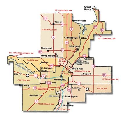
environment through the discharge of hydrocarbons. Moreover, an amorphous
landscape of workplaces, residences and commerce, if it is found in cities, courts
the risk that the extension of infrastructure and public services needed to
accommodate widespread or universal use of private vehicles will escalate the
cost of service provision beyond the limit of viability.

In these pages, we look at land use practices in Winnipeg, a typical example of a
sprawling North American metropolitan area, in order to gain a more detailed
view of how North America’s amorphous urban landscapes are created and what
problems they produce. Although sprawl is ubiquitous across urban North
America, Winnipeg’s situation is in other ways strikingly different from that of the
four city-regions that are the primary focus of this volume. Although like all 21st
Century cities, it is integrated “into a ...globalized urban network”, (Allahwala’s
and Keil’s characterization, in the introduction to this volume, of the four city-
regions), its primary connections are more limited.

A metropolitan area with a population that is forecast to reach 782,400 in 2013
(Winnipeg, City of, 2012), Winnipeg is a stand-alone city some 1300 kilometres
from Calgary, the nearest comparably-sized city. Located near the geographical
centre of North America, it is integrated into a continental transportation network
that extends south into Mexico and beyond, as well as to Atlantic, Pacific and
Arctic coasts. Its global connections are far more limited than those of Frankfurt,
Paris, Montreal and Toronto. Its population is growing slowly and its economy is
relatively stable. It boasts a lively and varied arts scene, but, unlike Toronto, does
does not claim cultural vanguard status.

Nevertheless, Winnipeg has been buffeted by the global winds that have blown
through cities across Europe and North America, producing accelerated
competitive pressure on local businesses in the wake of the North American Free
Trade Agreement and other globalizing initiatives; consequently, loss of
traditional manufacturing jobs, and growth of cheap-labour production and
services; and fiscal austerity, the effects of which have been accentuated by the
disappearance of regional equalization programs previously sponsored by the
federal government.

The focus of the present chapter is not global competitive pressures, but the
regional competition over land development that determines metropolitan growth
patterns. Like many North American municipalities, Winnipeg, and other rural
districts, urbanizing areas and cities in the metropolitan area, publish planning
documents which purport to show how a local or provincial (state in the United
States) planning process that ensures the efficient and effective delivery of public
transportation and other public services guides the growth of the metropolitan
area.

For those who follow the politics and administration of growth day to day, these
documents fail to conceal the fact that planning is, in reality, a clean-up operation
designed to legitimize decisions that are driven primarily by developers, and that

                                                                                    5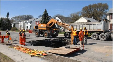
prioritize the interests of those developers, and of the residents of their new
neighbourhoods, over the interest of the city as a whole. A brief look at the city’s
early growth, and three development case studies, will provide evidence for this
statement, and show how the development process works in practice.

Winnipeg’s politics of urban growth
From the beginning, city planning in Winnipeg has been an aspiration, struggling
to catch up with reality. A pair of artists’ aerial views of Winnipeg from 1880-81,
on the following page, nicely illustrate this point. The first, captioned Picture 1,
shows a wide, unpaved street flanked on either side by buildings. In the
background we see scattered housing, apparently located, oriented and spaced
to suit the convenience of the individual property owner, rather than to conform to
any set pattern.

Picture 2 provides an overview of the city as it was then, and, superimposed on
the same scattering of buildings seemingly located at random, an extensive
street grid, likely someone’s aspirational view of what it was hoped the city would
become. From a distance, it appears that the locations of buildings are
uninfluenced by the grid.

Picture 1

The two pictures aptly foreshadow the future of planning in Winnipeg. The
Department of Planning, Property and Development produces a wealth of
planning documents, filled with statements that represent planning correctness
(See the entries under References below, entitled Sustainable Water and Waste:
An Our Winnipeg Direction Strategy; Sustainable Transportation: An Our
Winnipeg Direction Strategy; Our Winnipeg: It’s Our City, It’s Our Plan, It’s Our

                                                                                  6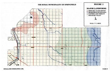
Picture 2

Time; Complete Communities: An Our Winnipeg Direction Strategy; Plan
Winnipeg 2020 Vision: A Long-range Plan for City Council), but the actual
directions for the growth and development of the city are driven by development
proposals. Planning documents ratify, and do the best their writers can, to justify
what has been decided by developers.

Meanwhile, developers cherry-pick the areas that are the easiest, the most
convenient, or the most profitable to develop and bypass others, secure in the
knowledge that the city will extend roads and other municipal services as
required by the new developments, regardless of the expenses incurred
ultimately by Winnipeg taxpayers. That includes, not only roads, sewerage and
water lines, but also transit service.

These expensive services have to be extended across lands that generate the
low levels of taxation typical of farmland or unoccupied tracts, rather than the
much higher taxes that come from urban development. Once occupied, new
developments beyond the empty tracts require conveniently located community
centres and library branches, and the same response times for fire fighters,
police, and paramedics that more densely populated areas of the city enjoy.
Street cleaning, snow removal, grass cutting, insect control, and everything else
the municipality does have to serve empty parcels of land as well as full ones.

                                                                                 7
Waverley West and Transcona West
There are many examples of land that earns minimal revenues, served and/or
bypassed, by the full range of municipal services, as we will see, but first, the
context: In 2006 Winnipeg City Council was debating how it should respond to
developer demands to make a vast new tract of land available for development.
The tract, known as Waverley West, contained enough land for decades of future
development, but developers, drawing on an analysis produced by the
Department of Property, Planning and Development (Winnipeg, Property,
Planning and Development, 2004: 13, 18), argued that it must be opened
immediately because, without it, the supply of lots available for development
would last only 8 to 10 years. City Council acceded to the developers’ demands.
At this writing, six years later, Waverley West is partly developed and developing
rapidly - though the bulk of it remains undeveloped - but substantial areas nearer
the centre of the city, and by-passed or serviced by older infrastructure and
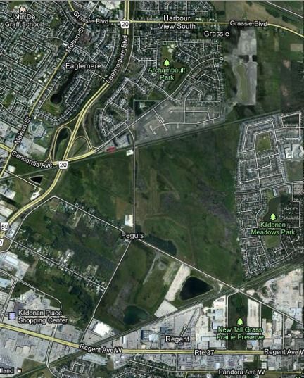
services, remain undeveloped. A particularly clear example - a comparison of
Waverley West (10.9 km. from the city centre) with an area called Transcona
West (7.6 km. from the centre) - provides visual images that come close to
capturing the magnitude of the problem. Following are Google Maps of Waverley
West and Transcona West, followed by a photograph of the Transcona West
tract, showing a sample of the amount of land available, but unoccupied, there.
8Map 1: Waverley West
Winnipeg’s planning practises are standard issue in North American city
planning. A critical assessment of the growth practises of most North American
cities would likely produce results not unlike those described in these pages,
although Winnipeg may well be a particularly egregious case. The egregiousness
is visible in the fact that, while the city’s infrastructure budget is lavished on first-
class roads, sewers and water lines serving new subdivisions, older
infrastructure is allowed to deteriorate radically. Recent news reports in both
Winnipeg newspapers, the Winnipeg Free Press and the Winnipeg Sun, confirm
earlier studies. (Leo and Brown, 2000, 201-05; Leo and Anderson, 2006, 181-83)
9Map 2: Transcona West and developed land to the east that must be served
by infrastructure and services traversing empty land.
10Picture 3: Transcona West
The Sun (Turenne, 2011) reported that, by the city's own reckoning, more than 20
per cent of the city’s streets are rated in poor condition, the lowest rating,
meaning that the street must be completely rebuilt, or at least undergo major
rehabilitation. A few days later, the Free Press (Skerritt, 2011) added some
figures to show that the roads are continually getting worse and that the city is
not anywhere near having the resources it needs to repair the streets quickly
enough to keep pace with their deterioration. (See Picture 4 and Picture 5 below)
Instead, the city has, in effect, given up on attempts to solve the problem. A
public works official admitted to the Sun that the city's priorities are shifting away
from streets in poor condition to those that have not yet reached that state, on
the premise that it is better to maintain what is viable than to salvage what is not.
Since the streets in worst condition tend to be those in the poorest
neighbourhoods, the neglect of downtown streets is tantamount to the
ghettoisation and decay so distressingly familiar in American cities.
Anyone who observes these conditions and then reads Plan Winnipeg 2020
Vision (Winnipeg, City of, 2000) will find himself suffering an attack of cognitive
dissonance. The plan, read in isolation from on-the-ground observation, will leave
him in no doubt that it is resolved to apply planning profession’s best practises.
11Using mandatory language, the plan (Winnipeg, City of, 2000, p. 29) promises
that:
The city shall promote compact urban form in support of sustainability by:
i) approving new residential, commercial and industrial
subdivisions only when... a full range of municipal infrastructure
can be provided in an environmentally-sound, economical, and
timely manner;
ii) evaluating residential, commercial development proposals using
benefit-cost analysis to measure long-term revenues,
expenditures, and impacts on existing developments within a life-
cycle costing framework;
iii) meeting transportation demand in ways which reduce reliance on
the automobile, improve integration of transportation modes, and
improve effectiveness of the existing transportation system;
iv) encouraging infilling of vacant lands and the revitalisation of
existing neighbourhoods to maximise the use of existing
infrastructure; and compatible with, existing development and
which is designed to minimise the spatial use of land.
v) supporting new development which is adjacent to, and
compatible with, existing development and which is designed to
minimise the spatial use of land.
It is evident that there is no correspondence between the thought processes that
went into the writing of the plan and those that govern actual development. To be
sure, point i), the promise to provide “...a full range of municipal infrastructure... in
[a]... timely manner...” is kept, but if there were any serious consideration of
either environmental soundness or economy, as promised in point i), the idea of
ensuring that new development be adjacent to existing development would have
suggested itself immediately.
Point ii), the use of benefit-cost analysis, in the conceptions of the Department of
Planning, Property and Development, is very straightforward. When a new
development is proposed, costs to the city are calculated in three categories: the
building or development of roads, parks and underground municipal services.
These costs are totalled, and charged to the developer. The developer is then
deemed to have covered “all the costs” of the development. Not counted in the
calculation are other costs referred to above: The provision of fire, police, and
paramedic response times comparable to those that more densely populated
areas of the city enjoy; street cleaning, snow removal, grass cutting, insect
control, and everything else the municipality does. In short, the benefit-cost
12analysis, in effect, counts all the benefits, but overlooks many of the costs. (Leo,
2002, pp. 219-21)
Picture 4: Winnipeg: Potholes on an inner-city street.
13Picture 5: Winnipeg, sinkhole on Corydon Avenue, April 26th, 2012.
Flikr.com, 7116691177_7ed9473e9b_z.jpg Corydon is located in one of the
older neighbourhoods surrounding the city centre.
The reference to reducing “reliance on the automobile, improv[ing] integration of
transportation modes, and improv[ing] effectiveness of the existing transportation
system” (point iii) is largely humbug. Until recently, the only public transportation
Winnipeg offered was an old-fashioned bus system, which - though its officials do
an impressive job of making a virtue of their limitations - reduces reliance on
automobiles only for that minority of commuters who are willing to put up with the
discomfort and inconvenience of buses. The only other gesture toward improved
public transportation has been the recent completion of the first half of a single
bus rapid transit line (the first of six that have been in the plan for some 40
years).
A glance at Maps 1 and 2 and Picture 3 above is enough to expose the chicanery
in the suggestion, in Point iv), that city policy encourages the infilling of vacant
lands, maximises “the use of existing infrastructure” or minimises the “spatial use
of land.” The only truth in that statement is that the city has been impressively
successful in a series of initiatives to revitalise the homes - but not the streets - in
older, inner-city neighbourhoods. Point v) essentially repeats the falsehoods in
Point iv), and they do not gain veracity in the retelling.
In short, the development of new neighbourhoods - Plan Winnipeg 2020 Vision to
the contrary - has been guided, not by the theoretical invocation of good planning
practise, but by the demands of different developers to develop on their own
pieces of land, in their own time and at their own pace. The city has followed their
lead obediently, constructing the infrastructure necessary to give them whatever
they have asked, largely regardless of cost. The appearance of planning is
14constructed retrospectively, to conceal a reality that looks orderly, but lacks the
coherence needed to permit the development of a viable and affordable network
of services and system of public transportation.
Springfield Municipality: A Classic Zwischenstadt,
Rationalised by Planning Jargon
Most of the population of the Winnipeg metropolitan area (Map 3) is located in
the central municipality of Winnipeg, in which, as our look at maps and
photographs has shown, there remains ample space for further development.
Surrounding Winnipeg are a small city, Selkirk, a town, Stonewall, and 13 rural
municipalities. Most of these municipalities compete with Winnipeg to attract
residential and other development. In this section, we look at the development
plan for one of those municipalities, Springfield, and contrast it with the reality of
the way the municipality is developing.
In their discussion of planning principles, the Winnipeg planners were content to
invoke such uncontroversial planning principles as environmental sustainability
and spatial compactness, and claim, in defiance of the facts, that these
motherhood statements constituted Winnipeg’s guiding principles.
Springfield’s planners work harder. The plan (Springfield Rural Municipality, 2011)
sets out a convincing analysis of Springfield’s landforms (Map 4).
• Red River Valley
• Birds Hill Kame Deposit
• Eastern Lake Terrace
• Brokenhead River Basin
This definition is followed up by some sensible general principles, such as
• Preservation of agricultural viability and natural resources
• Separation of heavy industry from other uses
• Concentration of commercial and light industrial uses in urban centres
• Prevention of proliferation of residential development, especially along
highways.
15Map 3: Winnipeg Capital Region
Source: Manitoba Local Government, 2012.
The four land forms include:
• Two high-potential agricultural areas, the Red River Valley and the
Brokenhead River Basin
• The Birds Hill Kame Deposit, near a provincial park, that is the prime source
of ground water for the municipality and
• The Eastern Lake Terrace, which is defined as having lower agricultural
potential.
16Map 4: Springfield Municipality Landforms
Source: Springfield Rural Municipality, 2012.
A substantial scholarly literature cites a variety of ways that residential
development in farming areas damages the viability of agriculture: complaints
from residents about smells, heavy machinery on roads and other perceived
nuisances resulting from agriculture; residential activities that interfere with
farming operations such as commuter traffic, harassment of farm animals by
pets; and escalation of land prices that inflate the cost of farming. (Leo et al,
1998)
The proposed Springfield official plan itself states that the growth potential of
livestock husbandry has already been limited by past residential development.
(Springfield Rural Municipality, 2011, 28) To this point in the plan, therefore, an
analysis of land forms has indicated the location of good agricultural areas (See
Map 5 below) and important water resources, while statements of objectives
have stressed the determination to preserve these assets in the face of
urbanization.
However, when we turn to the part of the plan in which proposed zoning
categories are set out, it appears that we are reading a different plan. Most of the
residential development is in the larger of the two prime agricultural areas and in
the area where the major resource of ground water is located. All the residential
development on top of the prime water resource relies on septic tanks for
sewage disposal, which invariably poses a greater risk to ground water than a
17community sewage system. There is a cluster of residential development planned
as well in the community of Anola, which is located in the low-potential
agricultural area and would therefore seem to be the natural area for urban
development if harm to agriculture were to be minimized, but that community can
only accommodate a limited amount of development because it has not been
provided with the water and sewage services needed for higher concentrations of
development.
Nor are there any plans for providing Anola with services, even though the plan
states that there is a demand for residential development there. Meanwhile, two
urban communities in the middle of the prime agricultural area, Oakbank and
Dugald, have been provided with the services required for higher concentrations
of urban development. In short, everything possible is done to encourage urban
development in those areas which the plan claims a determination to protect, and
almost nothing done to encourage development in the area that the plan
designates as unsuitable for other purposes.
Attendance at two hearings of the municipal board panel (17 May and 24 May
2000) provided insights into the sources of this exercise in appearing to plan
without actually doing so. From a variety of statements that were made, it
became clear that numerous residents of the municipality had been able to
improve their fortunes by subdividing farmland in the past, in order to sell it for
residential development, and that others wished, at the time of the hearings, to
follow suit. When witnesses at the hearing called attention to the gap in the plan
between objectives and proposed outcomes 2 the argument was repeatedly made
that, since some had been allowed to subdivide their land, it was not fair to
restrict others from doing so.
In short, the municipality was meeting its legal obligations by providing something
that resembled a plan, but political pressures from constituents in a community
small enough to allow almost anyone to have a personal relationship with her or
his representative on council prevented the municipality from adhering to the
principles stated in the plan. In a community as small as this one, it is not
necessary to imagine overt corruption of decision-makers through the offer of
inducements to neglect their duties in order to understand what is happening. In
the absence of clear provincial planning guidelines, pressures on council are too
immediate and too personal to permit genuine planning. It is those who stand to
gain from development that largely determine the way the community will
develop. The political realities of the planning process defeat aspirations to sound
urban planning.
2I
was present at the hearing as a witness, invited to testify as an expert, and I
was one of several of those present who pointed to the gap.
18Map 5: Springfield Municipality Agricultural Capability
Source: Manitoba, Agriculture, Food and Rural Initiatives, Soil and
Landscape Management Section, 2011, p. 16
Conclusions
Although many of the details of Winnipeg’s politics of urban planning differ from
those in Springfield Rural Municipality, the fundamental problem is the same in
both jurisdictions: The decision-makers are too close to those who will be
affected by decisions to allow for a reasonable expectation that development
practise will be governed by planning principles. When developers and individual
citizens are well-placed to offer or withhold financial or other inducements,
including friendship in the case of Springfield, it is unreasonable to expect that
good planning practise will trump individual interest. As long as local politicians
remain responsible for applying planning principles, planning aspirations will
continue to be trumped, and chaotic development will remain the inevitable
outcome.
19References
Bourne, Larry S., Tom Hutton, Richard G. Shearmur and Jim Simmons. 2011.
Canadian Urban Regions: Trajectories of Growth and Change. Don Mills,
Oxford University Press.
Galston, Robert. 2009. “The Failures of Waverley West.” Winnipeg: Winnipeg
Free Press, 23 February.
Keil, Roger and Douglas Young. 2009. “Fringe Explosions: Risk and Vulnerability
in Candada’s New In-Between Landscape.” The Canadian Geographer
53:4, 488–499.
Leo, Christopher. 2002. “Urban Development: Planning Aspirations and Political
Realities.” In Edmund P Fowler and David Siegel, eds., Urban Policy Issues
(second edition). Toronto: Oxford University Press, 215-36.
Leo, Christopher and Katie Anderson. 2006. “Being Realistic about Urban
Growth.” Journal of Urban Affairs. 28:2, 169-89.
Leo, Christopher and Wilson Brown. 2000. “Slow Growth and Urban
Development Policy.” Journal of Urban Affairs 22:2, 193-213.
Leo, Christopher with Mary Ann Beavis, Andrew Carver and Robyne Turner.
1998. “Is urban sprawl back on the political agenda? Local growth control,
regional growth management and politics.” Urban Affairs Review, 34 (2),
179-212.
Manitoba, Agriculture, Food and Rural Initiatives, Soil and Landscape
Management Section. 2011. Soils of the Municipality of Springfield.
Winnipeg: Author
Manitoba Local Government. 2012. “Welcome to Manitoba’s Capital Region.”
Winnipeg: Author. Accessible at http://www.gov.mb.ca/ia/capreg/index.html
Polése, Mario. 2009. The Wealth and Poverty of Regions: Why Cities Matter.
Chicago: University of Chicago.
Sieverts, Thomas. 2003. “Urbanität und Zwischenstadt”, in Forschungsgruppe
Bodenseestadt (Hrsg.): Vision Bodenseestadt. Städtebauforschung
zwischen Utopie und Machbarkeitsstudie. Weimar: VDG pp. 138–149. ISBN
3897393557.
_______. 2000. “Zwischenstadt, zum Stand der Dinge“, in: archithese,
Sondernummer, Nov. 2000, S. 6–11.
_______. 2003. Cities without cities: An interpretation of the Zwischenstadt.
20London, New York: Spon Press.
Skerritt, Jen. 2011. “City Streets Rougher, Data Show.” Winnipeg: Winnipeg Free
Press, 21 November 2011.
Springfield Rural Municipality. 2011. Development Plan By-Law No. 98-22.
Winnipeg: Author.
Springfield Rural Municipality. 2012. “Planning Department.” Winnipeg: Author.
Accessible at http://www.rmofspringfield.ca/pdf/page%2014%20-%20figure
%202%20major%20landforms.pdf.
Turenne, Paul. 2011. “Winnipeg’s Roads to Ruin.” Winnipeg:” Winnipeg Sun, 13
November 2011.
Winnipeg. nd. A Sustainable Winnipeg: An Our Winnipeg Direction Strategy.
Winnipeg: Author.
Winnipeg. 2000. Plan Winnipeg 2020 Vision: A Long-range Plan for City Council.
Winnipeg: Author.
Winnipeg. 2012. Community Trends Report: Selected Demographic and
Economic Information. Winnipeg: Author.
Winnipeg. 2012. “Population of Winnipeg.” Winnipeg, March 16th.
Winnipeg. nd. Complete Communities: An Our Winnipeg Direction Strategy.
Winnipeg: Author.
Winnipeg. nd. Our Winnipeg: It’s Our City, It’s Our Plan, It’s Our Time. Winnipeg:
Author.
Winnipeg. nd. Sustainable Transportation: An Our Winnipeg Direction Strategy.
Winnipeg: Author
Winnipeg. nd. Sustainable Water and Waste: An Our Winnipeg Direction
Strategy. Winnipeg: Author.
Winnipeg, Planning, Property and Development. 2004. City of Winnipeg
Residential Land Supply. Winnipeg: Author, October.
Young, Douglas, Patricia Burke Wood and Roger Keil. 2010. In-Between
Infrastrudture: Urban Connectivity in an Age of Vulnerability. Kelowna, B.C.:
Praxis (e) Press.
21You can also read