The problems of spatial planning and natural determinants of urban development - the Case of Powiśle in Warsaw
←
→
Page content transcription
If your browser does not render page correctly, please read the page content below
JOURNAL OF WATER AND LAND DEVELOPMENT
                                                                      e-ISSN 2083-4535

               Polish Academy of Sciences (PAN)                Institute of Technology and Life Sciences – National Research Institute (ITP – PIB)

                                                      JOURNAL OF WATER AND LAND DEVELOPMENT
                                                              DOI: 10.24425/jwld.2021.137688
                                                                2021, No. 50 (VI–IX): 1–9

      The problems of spatial planning and natural determinants
       of urban development – the Case of Powiśle in Warsaw

                                            Joanna Koszewska1),                 2), 3)
                                                                                                     , Łukasz Kuzak3)
                             1)
                                  Sorbonne Université – Faculté des Lettres, Ecole Doctorale de la Géographie de Paris,
                                           Institut de Géographie, 191, Saint Jacques, 75005, Paris, France
                                    2)
                                         Warsaw University of Technology, Faculty of Architecture, Warszawa, Poland
       3)
            Warsaw University of Technology, Faculty of Geodesy and Cartography, Plac Politechniki 1, 00-661 Warszawa, Poland

       RECEIVED 01.04.2020                                                   REVIEWED 29.09.2020                                        ACCEPTED 14.11.2020

       Abstract: This research examines the relationship between urban planning and environmental conditions. As urb-
       anisation processes increase the density of the built-up tissue of cities, this process puts a lot of pressure on land and
       natural resources such as rivers and soil. This article aims to verify whether environmental risks (e.g. flooding) and land
       protection from them is sufficiently addressed in the examined spatial policies and strategies.
             This problem can be observed in the Powiśle district of Warsaw where buildings are constructed in the proximity
       of the unregulated Vistula River and that is why there is the direct risk of flooding. It is done despite the lack of legally
       binding Master plans which would consider the natural risk.
             The literature research on the Municipality-led spatial planning policies and documents was completed with
       qualitative interviews with key actors in this process (planners: the authors of Master plans under construction,
       regarding the area of Powiśle South and North). Main designers and team members were asked about the priorities of
       these plans as well as their dynamics (taking more than ten years to establish those plans).
             An environmental analysis was conducted in the GIS mapping system of many databases. The comparison of both
       aspects of current development, formal urban planning and environmental protection was made in an interdisciplinary
       approach. The study presents an analysis of the situation for urban planning along with flood maps and other
       environmental conditions. The results show the lack of necessary alignment of environmental issues with the planning
       documentation and strategies.

       Keywords: urban planning, flooding protection, urban sustainability, city transformation, urban resilience

                             INTRODUCTION                                                  cities are exposed to the growing flood risk, according to some
                                                                                           forecasts other cities face the risk of draught conditions [ZIMNY
Recent decades have been a period of particularly rapid global                             2006].
climate change. This phenomenon is particularly noticeable in                                    The problem of adjusting activities related to minimising
urban areas and there are even separate terms such as “urban                               the effects of climate change in urban planning and urban
ecosystem” and “city climate” [ZIMNY 2006]. In the era of                                  sustainability issues have been raised in international literature in
progressing urbanisation modern cities face such problems as the                           recent years [KOOKANA et al. 2020]. Attempts have been made
urban heat island, stagnation of air caused by the build-up of                             worldwide to mitigate the effects of rapid precipitation using
aeration corridors, runoff of rainwater caused by the sealing of                           appropriate design solutions on a smaller scale: individual objects,
exposed land surfaces. Other negative aspects are degradation and                          benches, specially designed flagstones, or architectural entities.
devastation of land by industry and transport etc. Whereas certain                         On a larger scale designing climate-resilient streets and public

            © 2021. The Authors. Published by Polish Academy of Sciences (PAN) and Institute of Technology and Life Sciences – National Research Institute (ITP – PIB).
                                This is an open access article under the CC BY-NC-ND license (https://creativecommons.org/licenses/by-nc-nd/3.0/)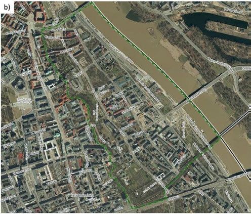
2                             The problems of spatial planning and natural determinants of urban development...

spaces as a part of public design activities might contribute to the                     given to nature (allowing it to be flooded in a planned manner),
improvement of climate sustainability. At the same time projects                         where the designers' intention was to continue the river landscape
are also being developed to transform entire city fragments. These                       of the Seine [KĘPIŃSKI 2020].
projects aim to alleviate climate catastrophes such as floods,                                 Venice suffered from heavy flooding at the end of 2019,
hurricanes, and storm impacts [KĘPIŃSKI 2020]. The proposed                              which has been repetitive for centuries. However, rising sea levels
solutions range from natural disaster protection to the absorption                       heighten the concerns about the city’s urban fabric. A project by
of their consequences within the cityscape. Therefore, this shows                        MOSE (from 2003) provides a system of storm gates to seal the
a change in the approach to city development (e.g. water from                            city’s lagoon from high tides in fifteen minutes [WALSH 2020].
intense rainfall of flood is not only seen as pollution to be                            (The lockdown in 2020 resulted in the purification of its canals).
removed as sewerage). The effects of climate change become                                     There are other examples of cities outside Europe under-
a foreseen stage of the project, integrating ongoing weather                             taking a natural risk plan and implementing strategies with
changes in the still functioning urban areas [KĘPIŃSKI 2020].                            methods for social change and urban regeneration. The following
       In terms of urban planning the areas at risk of negative flood                    towns and their plans are worth mentioning: Boston (the project
impact should be characterised by having appropriately estab-                            of the Mayor of the city with SCAPE Landscape Architecture
lished guidelines and restrictions. Their purpose should be to                           increasing the open space along the 76 kilometres coastline), New
enable their effective operation, including the obligatory intro-                        York City – the project for Brooklyn (New York City borough of
duction of “green and blue” infrastructure devices, or restrictions                      Brooklyn, Bjarke Ingels Group and Field Operations have
on the development of legal documents [SZULCZEWSKA 2009].                                developed a Master plan of mixed-use development and
       Globally, about forty percent of the human population lives                       a flood-resilient park to reinstate natural habitats, elevate the
within 100 km of a coastline [WALSH 2020]. Therefore, to act                             waterfront resiliency, and transform the inhabitants approach to
against damages caused by the rising flood risk, architects, urban                       the East River) [KĘPIŃSKI 2020]. Since 2019 New York City has
planners and designers of various specialisations react in order to                      been working on the plan of a coastal resilience project for Lower
respond to the need of undertaking action plans and projects.                            Manhattan, where half a billion dollars out of USD10 billion is to
These plans and projects aim to protect populations from                                 be dedicated to fortifying its terrain with grassy berms in parks
flooding by constructing resilient structures and developing                             and barriers. On the eastern part, the coastline is planned to be
schemes slowing or even reversing the effects of urban floods.                           pushed out by as much as 150 meters, generating a new public
Such actions combine local scale effects in the global context to                        space on a higher level, meeting rises in sea levels and storm
prepare and implement climate change resilient solutions                                 surges. Jew Jersey Hoboken has an OMA designed strategy to
[KĘPIŃSKI 2020].                                                                         protect from the high level of waters (elaborated after the coastal
       Copenhagen is the example of a model for a large European                         landfall of Hurricane Sandy in 2012) by combining hard
city (over 500,000 inhabitants) dealing with flood risks. In 2018 its                    infrastructure with soft landscaping, comprised of a green circuit
local authorities allocated 60 million DKK (approx. 8 million EUR)                       to trap water with water pumps to support drainage.
to a comprehensive project with a time horizon of 20 years aimed                               Similar works are also underway in the West of the USA. As
at flood protection [SCHIØLER 2018]. The “Copenhagen Climate                             part of the Resilient by Design Challenge program, architects
Adaptation Plan” was adopted setting out flood-fighting instru-                          (HASSELL+) are redesigning waterfronts in the San Francisco
ments annexed to local planning documents. Securing buildings                            Bay area. Inspired by the experiences of residents after the 1906
and infrastructure in Copenhagen is necessary as it helps to                             earthquake (and recurrent fires in California), they are organising
control flood water in the urban scale efficiently by expanding the                      temporary shelters in the open spaces of San Francisco; the
infrastructure network that drains and retains excess water by the                       project has networked parks, streams and shopping streets which
use of the so-called sponge texture, permitting the infiltration of                      will collect and distribute water during extreme weather events.
waters to the ground and underground tanks in public spaces in                           The network of interconnected reservoirs, collectors and canals
the heavily built-up city centre lacking green spaces.                                   create everyday use places that might serve local communities as
       Faaborg in Denmark has also an anti-flooding scheme,                              local crisis centres during disasters [KĘPIŃSKI 2020].
designed by Kjellander Sjöberg, it revives closed-down industrial                              Seoul integrates water into the fabric of the city itself by
areas by establishing a channel that regulates and diverts water                         providing a man-made valley below street level for the
away from the historical city centre [HARROUK 2019].                                     Cheonggyecheon River (once covered by roadways and highways,
       Hamburg in Germany is a case where the large-scale                                renovated in 2003), capable of accommodating the floodwater of
development (1.56 km2) of the flood risk was dealt with by                               rainy seasons, and serving as a recreational public space in dry
levelling the new built-up areas (8.5 m above the flooding zone).                        periods [WALSH 2020].
       In the case of densely populated cities, like Paris, retention                          To summarise, a resilient, regenerative urban design has
functions can be performed by urban parks, like the Billancourt                          become a necessity for many cities and zones at risk of flooding. It
Park (designed by Agence TER) in Boulogne Billancourt near                               should be accompanied by legal solutions, by defining the
Paris. This project was a part of a larger revitalisation plan of                        admissible type of investments and infrastructure of considered
a former industrial site which integrates the Seine River flowing                        zones. It could even go beyond protection strategies, towards the
nearby. The space located between the new quarters is                                    goal enriching the ecosystem and the quality of life for the
surrounded by meadows, ponds, gravel troughs, islands, and                               inhabitants of designed areas [NABONI et al. 2019] and the
wetlands, where its range varies depending on the weather                                implementation of climate resilient urban design solutions. All
conditions. The urban settlement, located in a hollow niche, is                          examples mentioned above are summarised in the Table 1, listing
surrounded by walls like port docks, thanks to which part of the                         all the cities facing flooding, types of flood and actions taken by
area always remains dry and available to residents. Another part is                      them to deal with it.

          © 2021. The Authors. Published by Polish Academy of Sciences (PAN) and Institute of Technology and Life Sciences – National Research Institute (ITP – PIB).
                              This is an open access article under the CC BY-NC-ND license (https://creativecommons.org/licenses/by-nc-nd/3.0/)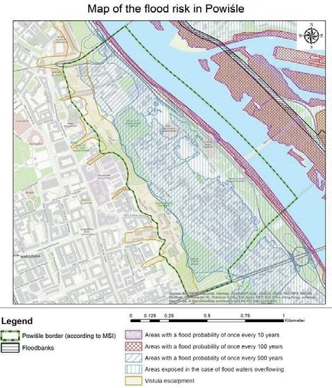
Joanna Koszewska, Łukasz Kuzak                                                                         3

Table 1. Examples of cities solutions for minimising flood risk

          Example                      Type of flood                                                   Action taken to deal with it

 Copenhagen (Denmark)               pluvial                   “Copenhagen Climate Adaptation Plan”, flood-fighting instruments annexed to local planning
                                                              documents, infrastructure network that drains and retains excess water
 Faaborg (Denmark)                  pluvial, coastal          channel, which regulates and diverts away water from the historical city centre
 Hamburg (Germany)                  fluvial                   levelling the new built-up areas in flood risk terrains (28 feet above the flooding zone)
 Paris (France)                     pluvial, fluvial          downtown parks as a source of retention, combining flood protection with revitalisation plans
                                                              for a former industrial site
 Venice (Italy)                     coastal                   system of storm gates to seal the city’s lagoon from high tides in fifteen minutes
 Boston, New York (USA)             coastal                   natural risk plan and implementing strategies with methods for social change and urban
                                                              regeneration, fortifying terrain with grassy berms in parks and barriers, combining hard
                                                              infrastructure with soft landscaping
 San Francisco (USA)                coastal                   the network of interconnected reservoirs, collectors, and canals
 Seoul (S. Korea)                   pluvial, fluvial          man-made valley below street level for the river, capable of accommodating floodwater of rainy
                                                              seasons and serving as a recreational public space in dry periods
 Powiśle (Poland)                   pluvial, fluvial          attempt of the climate change mitigation fulfilled insufficiently in regulatory documents, as Study
                                                              of Conditions and Directions of Spatial Development and in Master Plans

Source: own elaboration.

       Getting back to the Polish geographical context, based on the                       into other planning documents as a solution to present problems.
available data, it can be stated that in 2013 only 12% of floodplains                      Currently, since this program has no legal impact on planning
in Poland were covered by planning documents at the level of                               documents, it can only be treated as an optional reference for
a local spatial development plan (Master plan – “Miejscowy plan                            policymaking.
zagospodarowania przestrzennego”) [NIK 2013]. Only 30% of the                                    The other important document is Announcement 01/2020 of
surface of Poland is covered by master plans [NIK 2016].                                   the interdisciplinary Advisory Team on the climate crisis with the
       In the areas where the plans were legally binding, in most                          President of the Polish Academy of Sciences about climate change
cases, no prohibitions or restrictions on the possibility of building                      and water management in Poland. The announcement indicates
in flood risk areas were introduced [NIK 2013; 2016]. Similarly, in                        the need to take different types of action due to the increased risk
the Study of Conditions and Directions of Spatial Development of                           of torrential precipitation and floods, i.e. by increasing retention.
communes (Pol. Studium uwarunkowań i kierunków zagospo-                                    At the same time, it signals the need to prevent drought that
darowania przestrzennego), spatial development directions re-                              increasingly plagues the city, by introducing an appropriate
garding limitation of floodplain development are not usually                               network of green infrastructure [Komunikat … 2020].
specified. According to calculations conducted by the authors                                    The result of the following analysis is expected to confirm
during the research on spatial data in Warsaw in 2020, currently,                          the initial hypothesis regarding little consideration for environ-
it is about 25% of the floodplains within the scope of legally                             mental conditions and determinants of the urban densification in
binding plans. It can be said that there is some improvement, but                          the current spatial development process of the examined area.
it is still an insufficient result.                                                        The formulation of ways to improve consideration of environ-
       That is why this article aims to verify whether current                             mental problems in the analysed process might be the subject of
environmental conditions, with an emphasis on the problem of                               further studies.
flooding, are included in spatial development strategies and
policies of different levels and types. The single case study of
a district at risk of flooding was established for this query.                                                   MATERIALS AND METHODS
       Warsaw is the subject of the analysis, precisely one of its
districts – Powiśle, and has been chosen for the following study as                        Geo-spatial data and map information on environmental
one of the most dynamically transforming areas since the 19th                              conditions (soil-agricultural maps), geological (geological maps),
century. It is a part of Warsaw with an area of 1.2 km2, from the                          type of development (BDOT10k) and spatial development
south bordering with Solec, from the north with the Old Town,                              problems (documents and planning studies) [GUGiK 2015;
from the east with the Vistula River and from the west with                                2019; PIG 2006; UM 2018] have been used to conduct the
Śródmieście North and South. In 2019, Warsaw authorities                                   following analysis. The literature review of the subject and
adopted the Strategy of Adaptation to Climate Change for the                               qualitative half-open interviews with key authors of Master plans
Capital City of Warsaw to 2030 with a perspective 2050 Municipal                           for the Powiśle area – completing the cartographic study with
adaptation plan [KASSENBERG et al. 2019]. It attempts to mitigate                          insight comments of key actors were realised to verify the
development policies to climate change. The document mentions,                             research hypothesis elaborated on the basis of the initial query of
among others, climate related dangers, the risk of flooding in                             the spatial data. The mentioned above data, query of the literature
Warsaw, which relates to 25% of the capital’s area. The authors                            sources, spatial analysis in the GIS system, field visits and
suggest improving green and blue infrastructure to retain water.                           interviews with key actors (officials, experts) of the examined
They also mention the fact that such a policy should be integrated                         processes have all been applied to conduct the presented research.

            © 2021. The Authors. Published by Polish Academy of Sciences (PAN) and Institute of Technology and Life Sciences – National Research Institute (ITP – PIB).
                                This is an open access article under the CC BY-NC-ND license (https://creativecommons.org/licenses/by-nc-nd/3.0/)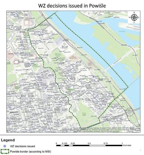
4 The problems of spatial planning and natural determinants of urban development...
RESULTS AND DISCUSSION of a riverbed. This resulted in a decrease of natural retention and
an increase of the intensity of surface runoff and the speed of
Based on the analysis of the literature on the flood risk in flood surge [BAŚCIK, DEGÓRSKA (eds.) 2015].
Warsaw, some dependencies can be observed. “In the 15th century This situation is also associated with changes in the course
there were six floods, of which the largest were witnessed in the of the riverbed within Powiśle (Fig. 2). Observing the borders of
following years: 1475, 1495, the 16th century: 1564, 1570, 1593, the riverbed from 1825 and 1841 the possibility of quite a large
the 17th century: 1605, 1635, 1647, 1667, 1671, the 18th century: change within a short time is visible, resulting in flooding of an
1724, 1729, 1736, 1751, 1774, 1775, 1782, 1788, the 19th century: important part of the surrounding (waterside) area. In the 20th
1808, 1812, 1813, 1814, 1830, 1837, 1839, 1840, 1844, 1845, 1855, and 21st centuries, a significant part of the banks were bolstered
1860, 1880, 1884, 1887 (Fig. 1), the 20th century: 1903, 1906, 1909, by levees. The Vistula boulevards on the embankments were also
1911, 1916, 1917, 1919, 1923, 1924, 1925, 1929, 1931, 1934, 1939, developed and the riverbed was regulated. This means that
1941, 1945, 1947, 1948, 1953, 1960, 1962, 1997, the 21st century: significant changes in its course should not be expected soon, but
2010 (Photo 1)” [ŚWIĄTEK, CHWISZCZUK 2012]. This listing could the potential for floods should not be underestimated.
indicate that there has been an increase in the frequency of flood Moreover, based on the following data, it can be indicated
phenomena since the nineteenth century, with a peak in the that Powiśle is located much lower than the rest of the city
twentieth century. This means that in the face of the increased (Fig. 3). A slight difference in the elevation of Powiśle and the
risk, an integrated, holistic approach to this problem is important. Vistula River level as well as the lack of embankments increases
The increased threat is also confirmed by the wider analysis the risk of pluvial and fluvial floods. This phenomenon is related
of the Vistula riverbed. The risk of flooding on the Vistula also to the high waves on the Vistula in early spring and high rainfall
continues to increase due to irrational economic human activity recorded in the summer – in June and July (Fig. 4).
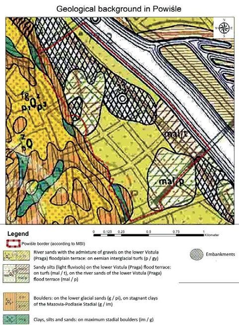
in the upper section of its basin. It mainly relates to the excessive The area of Powiśle is located to a large extent on sandy
regulation of river channels by cutting natural bends, the use of land, which is not a limitation on the development possibilities
stone lining of the channels as well as changes in land use, mainly [CHMIEL 2013]. However, a large area in the southern and central
road development, including asphalt. The shortening of the parts of the district is also located on silts (light fluvisols), which
course and narrowing of the riverbeds caused a rapid deepening are described as “useful for buildings with restrictions” (Fig. 5).
Fig. 1. Flood in Warsaw in 1887. Painting “Sandblasters” by Aleksander Photo 1. Flooded boulevards in Warsaw in May 2010; source: https://
Gierymski; source: MNW [undated] commons.wikimedia.org/wiki/File:Warsaw_Vistula_river_20100521.jpg
Fig. 2. Variability of the Vistula riverbed within Powiśle; source: own Fig. 3. Elevation map of Powiśle; source: own elaboration based on
elaboration based on obtained spatial data [UM undated b] obtained digital terrain model [GUGiK 2019]
© 2021. The Authors. Published by Polish Academy of Sciences (PAN) and Institute of Technology and Life Sciences – National Research Institute (ITP – PIB).
This is an open access article under the CC BY-NC-ND license (https://creativecommons.org/licenses/by-nc-nd/3.0/)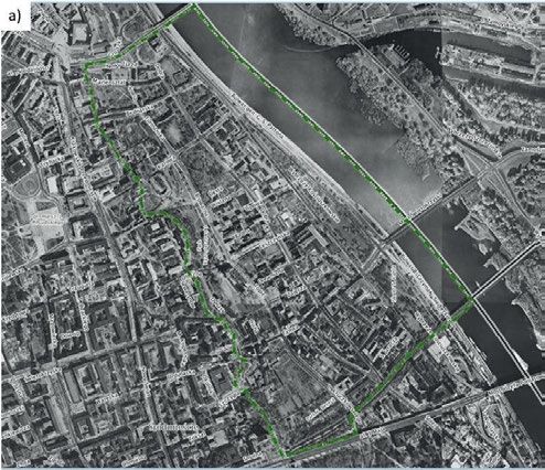
Joanna Koszewska, Łukasz Kuzak                                                                         5

                                                                                                These conditions have been included in the Study of
                                                                                          Conditions and Directions of Spatial Development of the Capital
                                                                                          City of Warsaw [UM 2018] by the designation of two types of
                                                                                          areas:
                                                                                              • the areas with a particular risk of flooding, which is subject
                                                                                                 to the prohibitions set out in the Water Law [Ustawa …
                                                                                                 2017] (the narrow strip of boulevards) – type 1,
                                                                                              • the areas at risk of flooding if flood waters overflow through
                                                                                                 the crown of the flood embankment or in case of damaging
                                                                                                 it (most of Powiśle area) – type 2.
                                                                                                Almost 30% of the Warsaw area is located in areas at risk
                                                                                          of flooding in the event of flood waters overflowing through
Fig. 4. Yearly rainfall precipitation data of Powiśle; source: own
elaboration based on https://www.meteoblue.com weather forecasts                          the crown of the flood embankment or its destruction or breach-
                                                                                          ing (type 2 above-mentioned), including a significant part of
                                                                                          Powiśle.
                                                                                                This can be confirmed by analysing the areas exposed to
                                                                                          floods visible below (Fig. 6), originated from the flood risk maps
                                                                                          developed by KZGW for Warsaw in 2015. They were compared
                                                                                          with the data included in the Study of Conditions and Directions
                                                                                          of Spatial Development of the Capital City of Warsaw [UM 2018].
                                                                                                It is worth mentioning that a new Study for Warsaw is
                                                                                          currently being developed (starting from May 2018) [Uchwała…
                                                                                          2018]. According to the assumption, the goal is to make Warsaw
                                                                                          more friendly to residents and resistant to climate change,
                                                                                          including green infrastructure solutions and minimising flood
                                                                                          risk.

Fig. 5. Map of the geological background in Powiśle; source: own
elaboration based on detailed geological map [PIG 2006]

However, these are lands much more useful for agriculture or
greening. Meanwhile, only some of them are intended in this way
and used for this purpose (Kazimierzowski Park, Kahl Square,
Daughters of Charity of Saint Vincent de Paul Monastery
Garden). These areas are also developed with buildings, both
residential and public.
      The restrictions on development options result from
                                                                                          Fig. 6. Map of flood risk in Powiśle; source: own elaboration based on
limitations of the bearing capacity of the ground [CHMIEL 2013].                          obtained spatial data [KZGW undated; UM 2018]
In many cases, the implementation of a construction investment
should then involve the need to secure the ground’s stability.                                  The flooding aspects should be considered everywhere, and
      Based on the data from the Polish Geological Institute [PIG                         detailed, multifaceted, balanced strategies should be created on
2006], in Powiśle the first aquifer is located shallow in the ground.                     their basis [SOLAREK et al. 2016]. Flood planning in Warsaw is
For the entire district, this depth varies from 2 to 5 m. This fact                       based on the “Flood Risk Management Plan for the Vistula River
should be considered when conducting any major construction                               Basin” developed by National Board of Water Management (Pol.
investments that could involve waterlogging of the ground.                                KZGW – Krajowy Zarząd Gospodarki Wodnej) and containing

           © 2021. The Authors. Published by Polish Academy of Sciences (PAN) and Institute of Technology and Life Sciences – National Research Institute (ITP – PIB).
                               This is an open access article under the CC BY-NC-ND license (https://creativecommons.org/licenses/by-nc-nd/3.0/)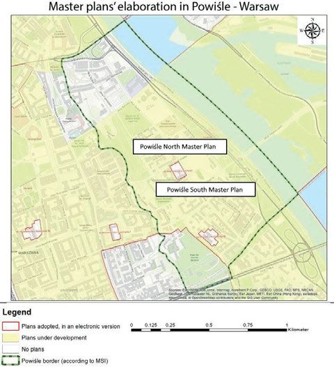
6                              The problems of spatial planning and natural determinants of urban development...

general guidelines for the entire river basin. Meanwhile, local                                 In addition, the new Water Law of July 20, 2017, introduced
documents focusing on Warsaw are limited to hardly accessible                             mandatory arrangements with the Polish Waters (Pol. Państwowe
documents from 1999, 2002 and 2004 developed by the Regional                              Gospodarstwo Wodne Wody Polskie) regarding the scope of devel-
Board of Water Management (Pol. RGZW – Regionalny Zarząd                                  opment directions for estates located in areas at particular risk of
Gospodarki Wodnej) in Warsaw (including the “Comprehensive                                flooding – where the probability of flooding is once every 100 years.
Regional Flood Protection Program in the Central Vistula basin                            However, there is still a lack of more detailed guidelines for areas of
in the RZGW in Warsaw” [RZGW 1999]). There is also a lack of                              potential danger – probability once every 500 years and in the event
adequate green infrastructure networks, partly reducing the risk                          of flood overflow through the crown of the flood embankment.
of flooding and the negative effects of climate change. Apart from                              However, this situation is somewhat comfortable from the
the boulevards, no large investments are aimed at sustainable                             point of view of potential investors. Unlike cities and voivodships
water management. In the Powiśle district, only an area of 1.5 ha                         which have developed special flood protection studies and
out of 120 ha is covered by the currently binding Master plans – it                       programs; in the face of an existing flooding threat in Powiśle,
represents 1.25% of the Powiśle surface. In other areas, there are                        no unequivocal instruments are protecting this area by limiting
two plans under development – for Powiśle North and Powiśle                               constructions. Not all housing estates are equipped with e.g.
South. For many reasons, they have not yet been adopted despite                           drainage systems [WAGNER et al. 2013], there are also no relevant
the planning process that has been going on for about ten years.                          restrictions and orders in planning documents (which, in the
The main of these reasons is the fact that Powiśle is in a large part                     absence of Master plans, are temporarily based on quite
of a flood plain where buildings cannot be built [BARTOSZEWICZ                            numerous WZ – decisions and building permits, Pol. decyzje
2012]. Moreover, the spatial plans generate conflicts of irreconcil-                      o warunkach zabudowy, which are particular plot used planning
able individual and group interests, transportation and environ-                          decisions not necessarily coherent with other decisions in the
mental problems and encounter issues related to unregulated                               neighbourhood and not required by law to be consistent with
ownership of plots. This also lengthens planning procedures,                              other planning documents of different levels).
which is unfortunately typical for Warsaw and should be changed                                 The map illustrating WZ decisions elaborated for the Powiśle
in the nearest future.                                                                    district shows that no such decisions have been issued for areas
      The rules and regulations have become more stringent                                threatened by the 10- and 100-year floods. They have, indeed,
because of the Water Law Act of January 5, 2011 [Ustawa …                                 been issued for the areas threatened by the 500-year floods, i.e. as
2011], which was a result of the implementation of the European                           a result of restructuring post-industrial areas. It is a positive phe-
Parliament Floods Directive [Directive 2007/60/EC]. RZGW had                              nomenon, compatible with the sustainable development principle.
a duty to develop detailed flood hazard and risk maps as well as                          But it will be better to combine this with available planning
flood risk management plans. The Floods Directive formulates                              instruments, e.g. municipal revitalisation program or local revital-
the obligation of updating all planning documents every six years.                        isation plan (a special type of local spatial development plan
Based on these regulations, RZGW refused to agree to a draft plan                         introduced in 2015 by a national law (Act of Revitalisation, Art.
for the Powiśle South submitted by the Warsaw authorities                                 15, paragraph 1, point 13) [Ustawa … 2015]. In fact, the Warsaw
(Fig. 7).                                                                                 Revitalisation Program (document of local strategy) covers only
                                                                                          three districts of Warsaw (Praga Północ, Praga Południe,
                                                                                          Targówek) and there is no single binding Local Revitalisation
                                                                                          Plan (a special type of Master Plan) in the whole city.
                                                                                                As a result, there is no uniform vision for the development
                                                                                          of post-industrial space in Powiśle and no real control over
                                                                                          a possible threat (Fig. 8).
                                                                                                In addition to the lack of planning documents, there is also
                                                                                          a problem connected with the lack of standards for conducting
                                                                                          planning studies in the field of water management and flood
                                                                                          protection. Thus, flood risk maps and integrated economic
                                                                                          assumptions are often not taken into account or the adoption of
                                                                                          plans is postponed significantly [NIK 2013].
                                                                                                So, it is visible that from year to year the threat concerning
                                                                                          the Southern Powiśle covered with compact buildings [DUDEK-
                                                                                          MAŃKOWSKA et al. 2018] is increasing. The Water Law Act
                                                                                          introduces a ban on constructing new and extending existing
                                                                                          buildings, digging wells and other works that may weaken the
                                                                                          stability of embankments at a distance of less than 50 m from the
                                                                                          foot of the embankment. However, there are no embankments in
                                                                                          this area, which means that no restrictions resulting from the
                                                                                          distance from the foot of the embankment can be introduced
                                                                                          (Water Law, Art. 176, paragraph 1) [Ustawa … 2017]. There is
                                                                                          a lack of coordination of this situation, and due to the high
                                                                                          historical value of these areas, more radical actions should be
Fig. 7. Map of coverage with local Master Plans in Powiśle in 2019;                       taken, e.g. in the form of developing drainage infrastructure for
source: own elaboration based on obtained spatial data [UM undated a]                     built-up areas and small retention reservoirs nearby.

           © 2021. The Authors. Published by Polish Academy of Sciences (PAN) and Institute of Technology and Life Sciences – National Research Institute (ITP – PIB).
                               This is an open access article under the CC BY-NC-ND license (https://creativecommons.org/licenses/by-nc-nd/3.0/)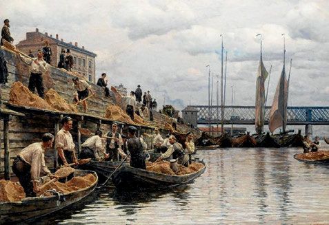
Joanna Koszewska, Łukasz Kuzak                                                                         7

Fig. 8. Decisions and building permits (WZ decisions) issued in Powiśle
until 2019; source: own elaboration based on obtained spatial data [UM
undated c]

      Based on an analysis of aerial photographs of Powiśle from
1990 and 2019 (Fig. 9), the tendency to develop river boulevards
can be observed. While in 1990 many post-industrial plots remain
non transformed into different functions, in 2019 many post-
industrial plots are transformed into different functions and
densified. These boulevards are ultimately intended to have
a recreational function for residents, but also to be one of the
dams for potential flood waters. In addition, buildings located on
the boulevards are equipped with special systems of anchors
allowing the pavilions built there to float on water, in the case of
a significant increase in the level of water in the Vistula. However,
it should be remembered that the boulevards are not equivalent to
levees and, as a result, there are no restrictions on a building
                                                                                          Fig. 9. Aerial photographies of Powiśle taken in: a) 1990 shows non-built
development at a distance of 50 m from them. It can still be                              riverbanks, b) 2019 shows concrete-built riverbanks; source: UM
concluded from an analysis of the available flood risk maps that                          [undated d]
despite the development of the boulevards the areas of Powiśle are
endangered and the current solutions are not sufficient to protect                        and in the practice of the implementation of urban construction
this area from flooding and its consequences.                                             projects, these aspects should be taken into account. Solutions
      In addition, the photographs presented below illustrate the                         such as the requirement for implementation of the absorbent
degree of transformation and development of the Powiśle area.                             surfaces in the flooding areas along with other design responses to
The transformation and revitalisation of industrial areas occur-                          the problem of combating the man-driven cause of climate
ring in the 1990s, include the Powiśle Power Plant, which was                             change should be applied. The hygienic quality of life in Warsaw
transformed for service, office, and residential constructions                            is at risk (in 2019 and 2020 by break downs of the local sewage
purposes [MACIEJEWSKA, TUREK 2019]. It should also be remem-                              treatment plant Czajka, affecting the water purity in the Vistula
bered that the new buildings are also still being built in areas at                       River).
risk of flooding, being implemented without major restrictions                                  Progressing urbanisation in the city should include a detailed
based on the aforementioned WZ decisions on building                                      analysis of environmental conditions, such as geological back-
conditions (Pol. decyzje o warunkach zabudowy).                                           ground, occurrence, and condition of groundwater purity.
                                                                                          However, it is also necessary to take into account aspects related
                                                                                          to the city's climate and adapting the area to the needs of
                             CONCLUSIONS                                                  minimising negative trends. This may take the form of technical
                                                                                          infrastructure devices or green and blue infrastructure.
In the context of a rapidly changing climate, the risk of flooding is                           However, it is ultimately necessary to create a comprehensive
increasing globally and locally, as in the case of Powiśle. In                            spatial planning system that takes into account all the mentioned
particular, in the research within the discipline of spatial planning                     above problems. This system should be based on plans which

           © 2021. The Authors. Published by Polish Academy of Sciences (PAN) and Institute of Technology and Life Sciences – National Research Institute (ITP – PIB).
                               This is an open access article under the CC BY-NC-ND license (https://creativecommons.org/licenses/by-nc-nd/3.0/)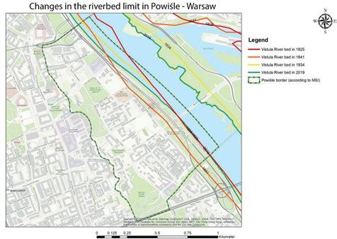
8                              The problems of spatial planning and natural determinants of urban development...

include all necessary components of sustainable development                                     evolution of Powiśle] [online]. [Poster]. [Access 9.03.2021].
and flood restrictions, constituting an alternative to mass                                     Available at: https://www.researchgate.net/publication/
development of non-coordinated particular decisions, frequently                                 325674933. DOI 10.13140/RG.2.2.35816.98565.
issued by WZ (Pol. decyzja o warunkach zabudowy). It is also                              GUGIK 2015. Baza danych obiektów topograficznych 10k [Database of
worth mentioning that if we are dealing with the post-industrial                                topographic objects 10k] [online]. Warszawa. Główny Urząd
area, the solutions introduced by the Act of Revitalisation (mu-                                Geodezji i Kartografii. [Access 9.03.2021]. Available at: https://
nicipal revitalisation program, local revitalisation plan) should be                            mapy.geoportal.gov.pl/
used.                                                                                     GUGIK 2019. Numeryczny model terenu obszaru Powiśla [Digital
                                                                                                terrain model of the Powiśle district] [online]. Warszawa.
       The result of insufficient coordination of environmental and
                                                                                                Główny Urząd Geodezji i Kartografii. [Access 9.03.2021].
revitalisation policies is particularly visible in the case of Powiśle
                                                                                                Available at: https://mapy.geoportal.gov.pl/
in Warsaw, where aspects of climate change and flooding appear
                                                                                          HARROUK C. 2019. Kjellander Sjöberg Wins Competition to Climate
not to be taken into consideration and new buildings are
                                                                                                Proof the Coastal Town of Faaborg in Denmark [online]. [Access
constantly being located on the floodplains. Despite the flooding                               17.02.2021]. Available at: https://www.archdaily.com/931112/
threats to the environment and a lack of agreement on the new                                   kjellander-sjoberg-wins-competition-to-climate-proof-the-coast-
construction development based on short decisions (WZ) from                                     al-town-of-faaborg-in-denmark
the Regional Board of Water Management (Pol. Regionalny                                   KASSENBERG A., SZYMALSKI W., DROGOSZ L., BUGAJ M., JAKUBCZAK I. 2019.
Zarząd Gospodarki Wodnej – RZGW), uncoordinated develop-                                        Strategia adaptacji do zmian klimatu dla m. st. Warszawy do roku
ment is continuing. A spatial development Master Plan                                           2030 z perspektywą do roku 2050. Miejski plan adaptacji
(Miejscowy plan zagospodarowania przestrzennego – MPZP) –                                       [Strategy of adaptation to climate change for the Capital City
which is a complex tool for urban planning might be a better                                    of Warsaw to 2030 with a perspective 2050 Municipal adaptation
instrument than particular urban decisions (WZ) for develop-                                    plan] [online]. Warszawa. Stołeczne Miasto Warszawa. [Access
ment in Powiśle. The complimentary elaborated planning                                          9.03.2021]. Available at: https://zielona.um.warszawa.pl/sites/all/
documents such as Master Plans coherent with strategies on                                      files/strategia_2030.pdf
a national and regional level would facilitate coordinated water-                         KĘPIŃSKI K. 2020. Woda [Water] [online]. Architektura i Biznes.
sewage and rainwater management for the benefit of an anti-                                     [Access 17.02.2021]. Available at: https://www.architekturai-
flooding system for Warsaw.                                                                     biznes.pl/woda,3123.html?fbclid=IwAR2hi1ZDgsSY9wP_uV-
       The Resolution of a new Study for Warsaw [Uchwała…                                       J6ZriLFJAVU7vt8pecII6uWBnkLQ6YMoElERrPJU
2018] together with the adopted Strategy for Adaptation to                                Komunikat 01/2020 interdyscyplinarnego Zespołu doradczego do
                                                                                                spraw kryzysu klimatycznego przy Prezesie PAN na temat
Climate Change [KASSENBERG et al. 2019], create a new procedural
                                                                                                zmiany klimatu i gospodarki wodnej w Polsce [Announcement
opportunity for the future improvement in the matter of more
                                                                                                01/2020 of the interdisciplinary Advisory Team on the climate
effective water and flood spatial management. A particularly
                                                                                                crisis at the President of the Polish Academy of Sciences about
important element of an effective planning system might be also
                                                                                                climate change and water management in Poland] [online].
a preparation of comprehensive local Master Plans, enriched with                                Warszawa. Polska Akademia Nauk. [Access 9.03.2021]. Available
precise flooding regulations. In addition, as presented in                                      at: https://informacje.pan.pl/images/2020/20200612_komuni-
exemplary cities policies, which have resulted in the mitigation                                kat_zespolu_doradcow_PAN_1.pdf
of the risk of flooding significantly, it seem legitimate for Warsaw                      KOOKANA R., DRECHSEL P., JAMWAL P., VANDERZALM J. 2020. Urbanisation
authorities to plan the network of a green and blue infrastructure                              and emerging economies: Issues and potential solutions for water
(e.g. in post-industrial areas), that would increase rainwater                                  and food security. Science of The Total Environment. Vol. 732,
infiltration and retention as well as limit climate anomalies.                                  139057. DOI 10.1016/j.scitotenv.2020.139057.
                                                                                          KZGW undated. Mapy zagrożenia powodziowego i mapy ryzyka
                                                                                                powodziowego [Flood hazard maps and flood risk maps]
                               REFERENCES                                                       [online]. Warszawa. Krajowy Zarząd Gospodarki Wodnej.
                                                                                                [Access 9.03.2021]. Available at: http://mapy.isok.gov.pl
BARTOSZEWICZ D. 2012. Zobacz, gdzie wyleje Wisła. Tu nie wolno                            MACIEJEWSKA A., TUREK A. 2019. Rewitalizacja terenów poprzemysło-
      budować [See where Vistula will pour out. You can't build here].                          wych [Revitalisation of post-industrial areas]. Warszawa. Wy-
      Gazeta Wyborcza. Nr 26.01.2012.                                                           dawnictwo Naukowe PWN pp. 150.
BAŚCIK M., DEGÓRSKA B. (ed.) 2015. Środowisko przyrodnicze Krakowa.                       MNW undated. Piaskarze. Gierymski, Aleksander (1850–1901) –
      Zasoby – ochrona – kształtowanie [The natural environment of                              malarz [Sandblasters. Gierymski, Aleksander (1850–1901) –
      Krakow. Resources – protection – shaping]. Kraków. Uniwersytet                            painter] [online]. Warszawa. Cyfrowe Muzeum Narodowe.
      Jagielloński pp. 290.                                                                     [Access 9.03.2021]. Available at: https://cyfrowe.mnw.art.pl/pl/
CHMIEL J. 2013. Analizy przestrzenne i modelowanie. W: Informacja                               katalog/511246
      przestrzenna dla samorządów terytorialnych [Spatial analysis and                    NABONI E., NATANIAN J., BRIZZI G., FLORIO P., CHOKHACHIAN A.,
      modelling. In: Spatial information for local governments]. Ed.                            GALANOS T., RasTogi P. 2019. A digital workflow to quantify
      S. Białousz. Warszawa. Oficyna Wydawnicza Politechniki War-                               regenerative urban design in the context of a changing climate.
      szawskiej p. 250–254.                                                                     Renewable and Sustainable Energy Reviews. Vol. 113, 109255.
Directive 2007/60/EC of the European Parliament and of the Council of                           DOI 10.1016/j.rser.2019.109255.
      23 October 2007 on the assessment and management of flood                           NIK 2013. Informacja o wynikach kontroli. Planowanie i realizacja
      risks [online]. [Access 9.03.2021]. Available at: https://eur-lex.                        inwestycji na terenach zagrożonych powodzią [Information on
      europa.eu/legal-content/EN/TXT/?uri=celex:32007L0060                                      the inspection results. Planning and implementation of invest-
DUDEK-MAŃKOWSKA S., GROCHOWSKI M., PORCZEK M. 2018. Ewolucja                                    ments in areas at risk of flooding]. Warszawa. Najwyższa Izba
      funkcjonalno-przestrzenna Powiśla [Functional and spatial                                 Kontroli pp. 73.

           © 2021. The Authors. Published by Polish Academy of Sciences (PAN) and Institute of Technology and Life Sciences – National Research Institute (ITP – PIB).
                               This is an open access article under the CC BY-NC-ND license (https://creativecommons.org/licenses/by-nc-nd/3.0/)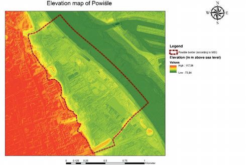
Joanna Koszewska, Łukasz Kuzak                                                                         9

NIK 2016. System gospodarowania przestrzenią gminy jako dobrem                             UM 2018. Studium uwarunkowań i kierunków zagospodarowania
     publicznym [System of the spatial governance of the commune as                             przestrzennego m.st. Warszawy [Studium uwarunkowań i kie-
     a public good]. Warszawa. Najwyższa Izba Kontroli pp. 30.                                  runków zagospodarowania przestrzennego m.st. Warszawy]
PIG 2006. Szczegółowa mapa geologiczna Polski [Detailed geological                              [online]. Warszawa. Stołeczne Miasto Warszawa. [Access
     map of Poland] [online]. Warszawa. Państwowy Instytut                                      9.03.2021]. Available at: http://www.architektura.um.warszawa.
     Geologiczny. [Access 9.03.2021]. Available at: http://baza.pgi.                            pl/studium
     gov.pl/resources.html?type=map50&id=524                                               UM undated a. Plany zagospodarowania [Master Plans] [online].
RZGW 1999. Kompleksowy, regionalny program ochrony przeciwpo-                                   Warszawa. Stołeczne Miasto Warszawa. [Access 9.03.2021].
     wodziowej dorzecza środkowej Wisły na terenie RZGW w War-                                  Available at: https://mapa.um.warszawa.pl/
     szawie. Ocena stanu zagrożenia powodziowego w obszarze                                UM undated. Wały Wisły [Vistula riverbeds] [online]. Warszawa.
     dorzecza środkowej Wisły [Comprehensive Regional Flood                                     Stołeczne Miasto Warszawa. [Access 9.03.2021]. Available at:
     Protection Program in the Central Vistula basin in the RZGW                                https://mapa.um.warszawa.pl/
     in Warsaw. Flood risk assessment in the middle Vistula River                          UM undated. Warszawa dzisiaj [Warsaw today] [online]. Warszawa.
     basin]. Warszawa. Regionalny Zarząd Gospodarki Wodnej                                      Stołeczne Miasto Warszawa. [Access 9.03.2021]. Available at:
     pp. 120.                                                                                   https://mapa.um.warszawa.pl/
SCHIØLER T. 2018. København afsætter 60 millioner til sikring mod                          UM undated. Warszawa historyczna [Historical Warsaw] [online].
     oversvømmelser [Copenhagen allocates 60 million to protect                                 Warszawa. Stołeczne Miasto Warszawa. [Access 9.03.2021].
     against floods] [online]. [Access 12.02.2021]. Available at: https://                      Available at: https://mapa.um.warszawa.pl/
     www.tv2lorry.dk/kobenhavn/kobenhavn-afsaetter-60-millioner-                           Ustawa z dnia 5 stycznia 2011 r. o zmianie ustawy – Prawo wodne oraz
     til-sikring-mod-oversvommelser                                                             niektórych innych ustaw [The Act of 5 January 2011 amending
SOLAREK K., RYŃSKA E.D., MIRECKA M. 2016. Urbanistyka i architektura                            the Act – Water Law and certain other acts], consolidated text.
     w zintegrowanym gospodarowaniu wodami [Urban planning and                                  Dz.U. 2011 nr 32 poz. 159
     architecture in integrated water management]. Warszawa.                               Ustawa z dnia 9 października 2015 r. o rewitalizacji. Tekst jednolity
     Oficyna Wydawnicza Politechniki Warszawskiej pp. 122.                                      [Act of Revitalisation 9 October 2015], consolidated text. Dz.U.
SZULCZEWSKA B. 2009. Plan zielonej infrastruktury: nowa moda czy                                2020 poz. 802.
     rzeczywista potrzeba? [Green Infrastructure Plan: a new fashion                       Ustawa z dnia 20 lipca 2017 r. – Prawo wodne. Tekst jednolity [Act of 20
     or real need?]. Studia KPZK PAN. T. 123 p. 89–96.                                          July 2017 – Water Law], consolidated text. Dz. U. 2020 pos. 310.
ŚWIĄTEK T., CHWISZCZUK R. 2012. Królowa Wisła [Queen Vistula].                             WAGNER I., KRAUZE K., ZALEWSKI M. 2013. Błękitne aspekty zielonej
     Warszawa. Fundacja CULTUS pp. 157.                                                         infrastruktury [Blue aspects of green infrastructure]. Zrówno-
Uchwała nr LXVII/1854/2018 Rady m. st. Warszawy w sprawie                                       ważony Rozwój – Zastosowania. No 4 p. 145–155.
     przystąpienia do sporządzania Studium uwarunkowań i kierun-                           WALSH N.P. 2020. How cities are using architecture to combat flooding
     ków zagospodarowania przestrzennego m.st. Warszawy [Resolu-                                [online]. [Access 12.02.2020]. Available at: https://www.arch-
     tion No. LXVII/1854/2018 of the Council of the Capital City of                             daily.com/931720/how-cities-are-using-architecture-to-combat-
     Warsaw on commencing the preparation of the Study of                                       flooding
     Conditions and Directions of Spatial Development for the                              ZIMNY H. 2006. Ekologia miasta [Ecology of the city]. Kraków. Agencja
     Capital City of Warsaw].                                                                   Reklamowo-Wydawnicza Arkadiusz Grzegorczyk pp. 233.

            © 2021. The Authors. Published by Polish Academy of Sciences (PAN) and Institute of Technology and Life Sciences – National Research Institute (ITP – PIB).
                                This is an open access article under the CC BY-NC-ND license (https://creativecommons.org/licenses/by-nc-nd/3.0/)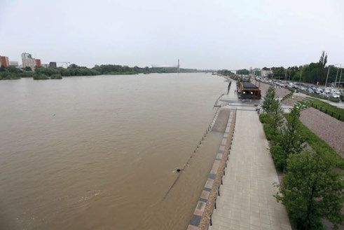
You can also read