2011Update TRANSPORTATION PLAN - Scoping Report
←
→
Page content transcription
If your browser does not render page correctly, please read the page content below
SOUTHEAST ALASKA
TRANSPORTATION PLAN
                     2011Update
                    Scoping Report

  Alaska Department of Transportation
          and Public Facilities
Alaska Department of Transportation and Public Facilities

Marc A. Luiken, Commissioner, Department of Transportation and Public Facilities
Pat J. Kemp, Deputy Commissioner, Highways and Public Facilities
Michael A. Neussl, Deputy Commissioner, Marine Operations
Al H. Clough, Director, Southeast Region
Jeff Ottesen, Director, Division of Program Development

Planning Team

Andy Hughes, Planning Chief, Southeast Region
Verne Skagerberg, Aviation Planner, Southeast Region
Jim Potdevin, Marine Systems Planner, Southeast Region
Stephanie Benson, Highway Planner, Southeast Region
Marie Heidemann, Non-Motorized Planner, Southeast Region
Christa M. Hagan, AMHS Planner, Alaska Marine Highway System
Dick Leary, Business Manager, Alaska Marine Highway System
Anthony G. Karvelas, Operations Manager, Alaska Marine Highway System

                                                     Prepared by Southeast Region Planning,
                                              Department of Transportation and Public Facilities

                                                                             In association with
 Alaska Marine Highway System, ADOT&PF: Ferry Traffic and Operations & Maintenance Cost
 Southeast Region Maintenance & Operations: Highway and Airport Operations & Maintenance
                                                                                    Cost
         Southeast Region Reconnaissance, ADOT&PF: Highway Traffic and Cost Estimating
                                         Sheinberg Associates, Juneau, AK: Public Review

This publication was released by the Alaska Department of Transportation and Public Facilities
and was produced and printed in Juneau at a cost of $6.62 per copy, for the purpose of distributing
the draft 2010 Update Scoping Report of the Southeast Alaska Transportation Plan. This
publication is required by Part 450, Subpart B, of Title 23 of the Code of Federal Regulations.

SOUTHEAST ALASKA
TRANSPORTATION PLAN
2011 Update Scoping Report
       August 2011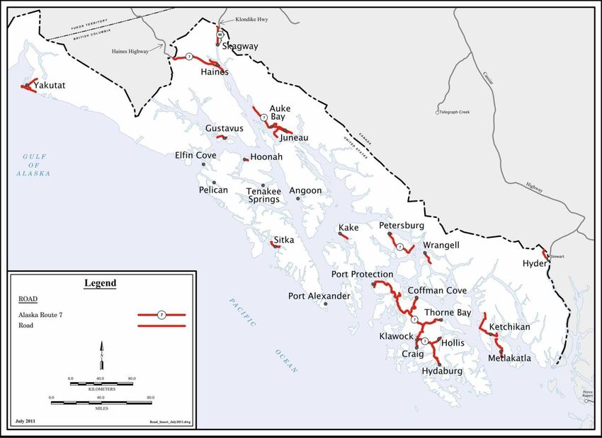

SEAN PARNELL, GOVERNOR

                                                                   PO Box 112506
DEPARTMENT OF TRANSPORTATION                                       Juneau, Alaska 99811-2506
                                                                   Phone:      (907) 465-4477
AND PUBLIC FACILITIES                                              FAX:        (907) 465-2016
                                                                   Email: verne.skagerberg@alaska.gov
            SOUTHEAST REGION PLANNING

    Dear Reader,

    This scoping report has been prepared as part of the Southeast Alaska Transportation
    Plan (SATP) update process. Its purpose is to provide information on the state of the
    region’s transportation system, explain the purpose and need for the update of the
    SATP, and describe a preliminary set of alternatives for the new plan.

    Beginning in the next few weeks, we will be hosting a series of public meetings around
    the region. It is our hope that this report will provide participants with a useful tool as
    they prepare for these meetings, and that it will serve as the basis for a productive
    discussion of the various possibilities we can compare and contrast as we work toward
    an updated plan. You are encouraged to review the scoping report and carefully
    consider the preliminary alternatives that it includes. These are not intended to
    comprise the final set of alternatives, but rather a starting point from which a final set
    will be developed. Your input at the public meetings, or provided to us separately if
    you are unable to attend, will be considered during the development of a draft plan.

    If you are unable to attend a public meeting, or want to provide us with your comments
    at any time during the scoping process, please send them to:

                DOT&PF – Southeast Region Planning
                PO Box 112506
                Juneau, AK 99811-2506
                Fax: 907-465-2016
                Email: dot.satp@alaska.gov

    Comments will be accepted until November 4, 2011.

    Following the first round of meetings, we will prepare a draft of the SATP that will
    present the set of alternatives that is developed through this scoping process, a
    thorough comparative analysis of the alternatives, and a draft recommendation
    concerning a preferred alternative. The draft plan will also be provided for public
    review and we will host a second round of public meetings to discuss its conclusions
    and get your comments.

    The final SATP will be prepared after the second round of meetings and after we have
    considered all of the input and feedback we receive.

    Thank you for taking time to review this document and participate in the update of the
    Southeast Alaska Transportation Plan. If you have questions or comments about any
other transportation issues that aren’t related to the SATP scoping process, please feel
free to contact one of us by phone or e-mail.

Andy Hughes                                    Jim Potdevin
Southeast Region Planning Chief                Southeast Region Marine Systems Planner
(907) 465-1776                                 (907)465-8864
andy.hughes@alaska.gov                         jim.potdevin@alaska.gov

Stephanie Benson                               Verne Skagerberg
Southeast Region Highway Planner               Southeast Region Aviation Planner
(907) 465-4445                                 (907) 465-4477
stephanie.benson@alaska.gov                    verne.skagerberg@alaska.gov

Marie Heidemann                                Christa Hagan
Southeast Region Non-Motorized Planner         Alaska Marine Highway System Planner
(907) 465-1775                                 (907) 228-6801
marie.heidemann@alaska.gov                     christa.hagan@alaska.gov

Southeast Alaska Transportation Plan — 2011 Update Scoping Report

Contents

THE SOUTHEAST ALASKA TRANSPORTATION PLAN ...................................1
    What is the SATP and why is it being updated? ....................................................1
    What is the process for updating the SATP? ..........................................................2
    Why are alternatives developed and how are they used? ....................................6

PURPOSE AND NEED .................................................................................................10

THE STATE OF THE SOUTHEAST TRANSPORTATION SYSTEM ................12

ALTERNATIVES DEVELOPMENT ..........................................................................20

PRELIMINARY ALTERNATIVES .............................................................................24
    Baseline Alternative 1 – Maintain the Existing System .......................................24
    Alternative 2 – Ferry Fleet Capacity Management ..............................................30
    Alternative 3 – Maximize Use of Existing Roads .................................................34
    Alternative 4 – Alaska Class Ferries .......................................................................38
    Alternative 5 – Highway Route 7 ...........................................................................44
    Alternative 6 – No Action ........................................................................................50

COMPARISON OF ALTERNATIVES ......................................................................54

                                                                i
Southeast Alaska Transportation Plan — 2011 Update Scoping Report

                       ii
Southeast Alaska Transportation Plan — 2011 Update Scoping Report
Tables
Table 1 - Frequencies for Existing Ferry Service .................................................................................. 16
Table 2. Alternative 1 - Frequencies for Existing Ferry Service ........................................................ 26
Table 3. Alternative 1 - Maintain Existing System ............................................................................. 27
Table 4. Alternative 2 - Frequencies for Fleet Capacity Mangement ............................................... 31
Table 5. Alternative 2 - Capacity Management................................................................................... 32
Table 6. Alternative 3 - Frequencies with Maximum Use of Existing Roads ................................. 35
Table 7. Alternative 3 - Maximize Use of Existing Roads ................................................................. 36
Table 8. Alternative 4 - Frequencies for One Alaska Class Ferry ..................................................... 39
Table 9. Alternative 4 - Frequncies for Two Alaska Class Ferries .................................................... 40
Table 10. Alternative 4 - Frequencies for Three Alaska Class Ferries.............................................. 41
Table 11. Alternative 4 - Alaska Class .................................................................................................. 42
Table 12. Alternative 5 - Frequency for Highway 7 Ferries .............................................................. 46
Table 13. Alternative 5 - Highway Route 7 ......................................................................................... 47
Table 14. Alternative 7 - Frequencies for Retirement of Ferries ....................................................... 52
Table 15. Comparison of user costs for roundtrip travel between SE Alaska hub communities
and Seattle ................................................................................................................................................. 55
Table 16. Comparison of user costs for roundtrip travel between SE Alaska hub communities
and Anchorage ......................................................................................................................................... 56
Table 17. Comparison of Ferry Service Frequencies .......................................................................... 57
Table 18. Present Value Cost Comparison of Alternatives ............................................................... 58
Maps
Map 1 AMHS Routes ............................................................................................................................... 14
Map 2 Inter-island Ferry Authority Routes.......................................................................................... 15
Map 3 Scheduled Air Service in Southeast Alaska.............................................................................. 17
Map 4 Southeast Alaska Highways ....................................................................................................... 18
Map 5 Existing Ferry Service .................................................................................................................. 28
Map 6 Ferry Fleet Capacity Management ............................................................................................ 33
Map 7 Maximize use of Existing Roads ................................................................................................ 37
Map 8 Alaska Class Ferries ..................................................................................................................... 43
Map 9 Development of Route 7 ............................................................................................................. 49
iiiSoutheast Alaska Transportation Plan — 2011 Update Scoping Report
Southeast Alaska Transportation Plan — 2011 Update Scoping Report

THE SOUTHEAST ALASKA TRANSPORTATION PLAN

WHAT IS THE SATP AND WHY IS IT BEING UPDATED?

The Alaska Department of Transportation and Public Facilities (hereafter the
Department or ADOT&PF) is designated in the Alaska Statutes 1as the agency
responsible for state highways, ferries, airports, and ports and harbors. The
Department is charged with the responsibility to develop statewide and regional
transportation plans to ensure that future transportation investments are in the public
interest. The Department’s mission is “to provide for the movement of people and
goods and the delivery of State services.”

The Southeast Alaska Transportation Plan (SATP) is one of a series of region wide,
multimodal transportation plans. The SATP was first published in 1980 and was
updated and revised in 1986, 1999, and 2004 as an approved component of the
Statewide Transportation Plan. State regulation (Section 05.130, Title 17, of the Alaska
Administrative Code [AAC]) provides that the Department shall develop a long-range
transportation plan for all areas of the state and that each component be reviewed and
updated every five years. This update is being developed in accordance with 17 AAC
05.130 and will comply with the Alaska Strategic Highway Safety Plan (2007) and the
Statewide Long-Range Transportation Policy Plan, Let’s Get Moving 2030 (2008).

The SATP provides a framework for state investment in regional transportation over
the ensuing 20 years; it takes into account the system’s condition and needs, provides
general direction for development of the regional system, and recommends specific
improvements. This update of the plan is necessary to ensure that it reflects changes in
the region’s industries, economy, population, and infrastructure since the previous 2004
update. In addition, this update will focus on the future sustainability of the regional
transportation system and the need to improve connectivity between communities
within the region.

1Section 02.10.010 of Title 2, Aeronautics, and Section 19.05.010 and Chapter 65 of Title 19, Highways and
Ferries.

                                                      1
Southeast Alaska Transportation Plan — 2011 Update Scoping Report
WHAT IS THE PROCESS FOR UPDATING THE SATP?
Public Involvement Plan
The Public Involvement Plan for the Southeast Alaska Transportation Plan Update will
assure that the public is:
• informed about the Alaska Department of Transportation and Public
Facilities (ADOT&PF) project to update the Southeast Alaska Transportation
Plan (SATP),
• invited to review and offer comments on proposed alternatives, and
• notified of public meeting dates and times.
General Public Notification
Project Contact List
The project contact list will include Southeast legislators, federal and state agencies,
local municipal officials, interested civic associations or community groups, and
interested public, including the department-maintained list of people who have
requested notice of such projects. Anyone who attends a public meeting or hearing,
requests information, or provides comments will be added to the project contact list.
This project list helps satisfy §17 AAC 05.140.
Project Web Site
ADOT&PF has a website for the Southeast Alaska Transportation Plan –
http://dot.alaska.gov/sereg/projects/satp/index.shtml
Project Information Sheet
The Department will develop a project information sheet that describes the purpose of
the SATP update, the proposed schedule and relevant contact information. This will be
distributed to the media and other interested parties.
Notice of Intent to Update the Plan
Notice of Intent to Update the SATP Plan, required by §17 AAC 05.135, was published
by ADOT&PF starting in October 2008, as follows:
• In the Juneau Empire, the Ketchikan Daily News and Sitka Sentinel in
October 2008.
• Letters were sent to legislators, municipalities, tribes, other interested parties
and those who were on the project contact list from the previous planning
process in October 2008.
• Notice was posted on the website starting in October 2008.
2Southeast Alaska Transportation Plan — 2011 Update Scoping Report
• The formal public notice was published on the Alaska Online Public Notice
System.
Publish Plan Assumptions and Alternative Scoping for Review
As background material for the SATP was completed, it was published on the website
for public comment. The people on the project contact list were notified that the
documents were available for public comment. Documents that were published
between October 2008 and August 2009 were the mission statement and goals, the
SATP Alternative Scoping, Transportation Alternatives, and the SATP Plan
Assumptions. Public comments were incorporated into the final mission statement and
goals.
A Scoping Report has been prepared, which shows a full range of preliminary
alternatives to be considered for the SATP update.
Public Scoping Meetings
The Scoping Report will be published following the same publishing process as was
used for previous documents. A series of public meetings will be held to gather input
on the alternatives presented and any new suggested alternatives.
Public Input Analysis and Reporting
This process will include summarizing and analyzing the issues raised, public opinions
regarding project alternatives, and other issues relevant to the SATP update. The
summary and analysis, including correspondence received, will be posted on the
website.
Publish and Distribute Draft SATP
Following public review of the Scoping Report, the Department will prepare a draft
SATP. Once the draft SATP is completed, it will be released and distributed for public
comment. The following steps will be completed:
• Post draft plan and cover letter on the website
• Send a message to contact list
• Mail paper copies of the plan to each local and tribal government, major
public libraries, select organizations, and to members of the public who
specifically request hard copy plans. These distributions are dependent on
the total number of copies that the DOT&PF budget allows to be printed.
Public Meetings & Public Input Analysis
The draft SATP will be published and available for public review. A series of public
meetings will be held and all public input will be compiled and analyzed. This
information will be used to write the final plan.
3Southeast Alaska Transportation Plan — 2011 Update Scoping Report
Adopt and Publish Final Plan
Once a final SATP has been adopted it will be posted on the website. Within 15 days of
the adopting the SATP, the Department will prepare and publish public notice of
adoption (17AAC 05.150). Public notice will be published in Juneau Empire, Ketchikan
Daily News, and Sitka Sentinel. Notice will be sent out to the project contact list.
Government Consultation Plan
The Government Consultation Plan for the Southeast Alaska Transportation Plan
Update will assure that affected local, regional, state, tribal and federal governments
are:
• informed about the Alaska Department of Transportation and Public Facilities
(ADOT&PF) project to update the Southeast Alaska Transportation Plan (SATP),
• invited to participate in the update and review process through consultation, and
• notified of additional opportunities to provide input, including public meeting
dates and times.
This consultation plan is made in accordance with:
• State of Alaska ADOT&PF Policy and Procedure #10.03.010 Government-to-
government relations with the federally recognized tribes of Alaska (March 2002)
• Alaska Department of Transportation and Public Facilities Non Metropolitan
Local Official Consultation Process (February 2011)
• AS 19.65.011 Comprehensive long-range plan. [Marine Transportation Advisory
Board (MTAB) Consultation]
• Code of Federal Regulations, Title 23 – Part 450 – Subpart B
o § 450.210 (b)(c)
o § 450.214 (g)(h);
Project Contact List
The planning staff will compile a contact list and add to and routinely update this list as
required. The project contact list will include Southeast legislators, federal and state
agencies, local municipal officials, tribal governments, tribal corporations, interested
civic associations or community groups, and interested public, including the
department-maintained list of people who have requested notice of
such projects. Anyone who attends a public meeting or hearing, requests information,
or provides comments will be added to the project contact list.
4Southeast Alaska Transportation Plan — 2011 Update Scoping Report
Project Web Site
DOT&PF has a website for the Southeast Alaska Transportation Plan -
http://dot.alaska.gov/sereg/projects/satp/index.shtml
Government Consultation Meetings
Staff will provide opportunity for consultation with:
− Tribal governments,
− Tribal corporations,
− Local governments/municipalities/organizations,
− Marine Transportation Advisory Board, and
− Interested and affected federal and state agencies.
Regional Advisory Associations
− Southeast Conference – a membership organization of community
officials and leaders
− Prince of Wales Community Advisory Council – a membership
organization of Prince of Wales Island communities and leaders.
All local municipal, borough, and tribal governments and state and federal
government agencies will receive all notices and information distributed to the
public.
5Southeast Alaska Transportation Plan — 2011 Update Scoping Report
WHY ARE ALTERNATIVES DEVELOPED AND HOW ARE THEY USED?
In the planning process, alternatives are developed to ensure that all the reasonable
potential solutions to a problem are considered and compared. However, it isn’t
necessary to analyze every conceivable possibility in order to craft an updated plan.
Many proposed solutions may not be feasible because of their cost or difficulty. Some
may be far too detailed for decision making at the planning level. Others may not meet
the draft purpose and need of the plan as presented herein.
In the case of the SATP, the Department has proposed a preliminary set of alternatives
that incorporate a range of operational concepts and encompass a set of reasonable
possibilities that may address the purpose and need statement for this update. The
purpose of the scoping process is to present these alternatives to the public, discuss the
impacts they may have on travelers, and explore other alternatives that might have
been overlooked.
The alternatives crafted for this analysis are designed to evaluate the following
concepts;
1. Alternative one is designed to identify what it may cost to maintain the existing
system and provides a baseline alternative against which all other alternatives
are compared.
2. Alternative two is designed to identify what the cost, benefits, and impacts
would be to manage our ferry fleet capacity in a way that more closely matches
current and future traffic demand.
3. Alternative three is designed to identify the costs, benefits, and impacts of
discontinuing ferry service between Southeast Alaska and Bellingham, Yakutat
or Whittier.
4. Alternative four presents an evaluation of the of replacing three aged mainline
ferries with three 350 foot “Alaska Class” ferries and a new mainline ferry.
5. Alternative five is designed to identify the costs, benefits, and impacts of
replacing the existing mainline ferry system with a system based on road
segments connected by shuttle ferries.
6. Alternative six is designed to evaluate what happens to the transportation
system, if we do not plan for replacement of the aged ferries.
The scoping process will include public review and meetings, collection of comments,
and a final review of purpose and need, mission, goals, assumptions, and projects
under development. Once these steps are complete, a final set of alternatives will be
developed. These may include variations of the preliminary alternatives and new ones
that come out of the public process. This set of alternatives will be analyzed to
6Southeast Alaska Transportation Plan — 2011 Update Scoping Report
determine which components will be incorporated into the draft SATP and presented to
agencies and the public for review and comment.
7Southeast Alaska Transportation Plan — 2011 Update Scoping Report
9Southeast Alaska Transportation Plan — 2011 Update Scoping Report
PURPOSE AND NEED
The proposed purpose and need for the Southeast Alaska Transportation Plan (SATP)
is:
Ensure the continuing opportunity to travel among the communities of Southeast Alaska to
meet basic needs and support the local and regional economy by providing the most
financially sustainable transportation system that resources permit.
People travel to meet a multitude of wants and needs, and the transportation system in
Southeast Alaska provides them the opportunity to do so. The SATP provides the
guidance to ensure that 1) the transportation system is operated, maintained, and
improved as needed to meet the transportation needs of the regional population, and 2)
the regional economy is not constrained by a lack of capacity or other transportation
problems.
Airlines, ferries, barges, and highways make up the Southeast Alaska transportation
system. Air carriers provide frequent and fast passenger service and transport time
sensitive air freight. Barge service provides the bulk of freight deliveries. Highways
and ferries allow people to travel with vehicles and a number of small outlying
communities rely on ferry service to meet their freight transport needs. Air and barge
service transportation needs are met by the private sector.
The state owns and operates most of the ferries, inter-community highways, and
airports in the region, but it has significantly different roles with regard to the traveling
public in each of these modes. In the case of the Alaska Marine Highway System
(AMHS), the state maintains the entire system including operating as a carrier. The
AMHS requires a substantial operating budget, which is largely funded through the
General Fund. For all other modes; drivers, pilots, air carriers, and freight companies
bear the cost of operating planes, cars, trucks, and barges. The state only incurs the cost
of maintaining the infrastructure that makes the use of them possible.
Transportation improvements are typically based on meeting demand and relieving
constraints; however, Southeast Alaska does not have a growing industry that is
overburdening its transportation system; no growing population is stressing the
capacity of the existing system; and economic data have not indicated that
transportation constraints are hampering development. Population and employment
have been nearly static for several years with little growth forecast for the next 20 years.
However, even without increasing demands on the transportation system, there are
problems that need to be addressed. The AMHS has several ferries that will soon need
replacement; the deferred maintenance list for state infrastructure is ever-growing; and
operating costs are rising for all modes. Furthermore, while state revenues that support
the operation of ferries, highways, and airports are expected to rise over the next
several years, the long term outlook is less clear. Perhaps the greatest concern is that
10Southeast Alaska Transportation Plan — 2011 Update Scoping Report
the capital funding—i.e., the large amount of federal dollars that make new ferries,
roads, and airports possible—is expected to decline substantially. As a result, the
Department must plan for the possibility of reduced financial resources to support
transportation infrastructure and operations for all modes of travel.
Therein lies the “need” driving this update of the SATP—the need to make changes to
the regional transportation system that make it more financially sustainable. Choosing
a set of actions that improves sustainability may extend the life of the system until
economic and population growth drive demand for its expansion. If changes that make
the regional transportation system sustainable also enhance service through increased
frequency or capacity or both, the Southeast region can enjoy a connected benefit or by-
product of having met the purpose and need. On the other hand, if frequency or
capacity is increased without reducing the annual operating budget, the need will fail to
be met and may result in significant reductions in service. Because changes to the
highway system and AMHS have the greatest potential to impact current inefficiencies,
they are the focus of the alternatives presented in this scoping report.
11Southeast Alaska Transportation Plan — 2011 Update Scoping Report
THE STATE OF THE SOUTHEAST TRANSPORTATION SYSTEM
Southeast Alaska is made up of the Alexander Archipelago (a 300-mile-long chain of
more than 1,000 islands) and the adjacent margin of the North American mainland.
From the northwest corner of the study area at Yakutat Bay to the southernmost point
(Cape Muzon on Dall Island) the region is about 450 miles in length – about the size of
the State of Florida. Residents of Southeast Alaska are distributed throughout the
region in isolated communities on the mainland and major islands, separated by
mountains and waters of the inside passage. Travel between the communities within
the region is severely restricted by geography, weather, and lack of connecting roads.
ADOT&PF maintains a transportation system that provides for travel between
communities and connects the region with the rest of the state and the continental
transportation system. The following list describes the components of the regional
transportation system that ADOT&PF constructs, maintains, and operates.
• The ADOT&PF Southeast Alaska regional roadway network largely consists
of arterial and major collector (primary) roads connecting communities to
airports and marine terminals. It also provides direct connections between
communities on Prince of Wales Island and to the continental highway
system from Haines, Skagway, and Hyder.
• An airport system composed of 11 airports and 23 public seaplane floats is
owned and operated by the state (Ketchikan International Airport is owned
by the state but operated under lease by the Ketchikan Gateway Borough).
• ADOT&PF owns and operates the ferry terminals and vessels that comprise
the Alaska Marine Highway System (AMHS). Additionally, AMHS uses and
provides maintenance or funding for a few municipally-owned ferry
terminals. AMHS provides connections among regional communities and to
the continental highway system through two ports to the south (Bellingham,
Washington and Prince Rupert, British Columbia), two within the region
(Haines and Skagway), and one to the north (Whittier).
The regional transportation system is not limited to the infrastructure and services
provided by ADOT&PF. Many communities own and operate roads within their
jurisdiction and the City and Borough of Juneau owns and operates Juneau
International Airport. Several communities and private air carriers own and operate
seaplane terminals throughout the region. Additionally, a multitude of carriers operate
on the waters of the Inside Passage including the Inter-Island Ferry Authority (IFA),
private contract ferry services, cruise ship lines, and barge lines. A new port authority,
Rainforest Island Ferries, is planning on providing ferry service between Coffman Cove
12Southeast Alaska Transportation Plan — 2011 Update Scoping Report
and Petersburg, Wrangell, and Ketchikan in 2012. These roads and waterways, and the
carriers who use them, contribute essential services to complete the regional
transportation system.
The regional transportation system faces many challenges. Although Alaskans are well
acquainted with and tolerant of the difficulties of traveling around Southeast, most
would likely want to see improvements in the system. However, providing reliable
transportation services comes at a significant financial cost to the State; constraints
affecting the ability to implement improvements include the tremendous rise during the
past several years in both operating and capital costs. Additionally, because
transportation services are needed by communities year-round, ADOT&PF cannot
eliminate or, in some cases, even reduce service when demand is low as many private
carriers do.
The level of demand for transportation that determines the requirements for the
transportation system is largely a function of population and economic activity.
Because those two factors have been relatively static in Southeast Region for several
years, the transportation system, with the exception of a few discreet segments, has not
required additional capacity. But, that doesn’t mean that it can simply continue to
operate as it does today. Vessels need to be replaced when they reach the end of their
useful life, roads have to be repaved, and so do airports. Unfortunately, the resources
available for making system improvements are not likely to increase in the foreseeable
future—in fact; they are more likely to decrease. But, there are also opportunities to
improve service where needed by reallocating existing resources. Therefore, it is
imperative that ADOT&PF choose a course of action that improves the economic
sustainability of the transportation system. Improving efficiency, reducing cost, and
getting the best results with capital expenditures are essential.
13Southeast Alaska Transportation Plan — 2011 Update Scoping Report
Core Regional Transportation Services
The Alaska Marine Highway and Inter-Island Ferry Authority
The current southeast AMHS route system, shown on Map 1, is divided into two
subsystems: the mainline coastal circuit routes, which typically take more than one day
for the ships to travel, and shorter point-to-point routes on which the vessels depart the
home port in the morning, travel to destination ports, and return to the home port on
the same day. The shorter routes are
commonly referred to as shuttle routes.
The mainline routes carry far more Map 1 AMHS Routes
passengers in summer than in winter—
nearly three quarters of their annual traffic.
They provide service from Bellingham,
Washington, and Prince Rupert, British
Columbia to Skagway, Alaska. On these
routes, the ships stop in Ketchikan,
Wrangell, Petersburg, Sitka, Juneau, and
Haines. Although smaller than the typical
communities served by mainline routes,
Kake and Hoonah are served by certain
mainline sailings to ease scheduling.
The five largest AMHS vessels are used on
the Southeast mainline routes: M/V
Columbia, M/V Kennicott, M/V Malaspina,
M/V Matanuska, and M/V Taku.
Shuttle routes connect the smaller
communities of Southeast Alaska with each
other and the larger communities of
Ketchikan, Sitka, and Juneau; which serve
as regional centers for commerce,
government, health services, and
connections to other transportation
systems. The shuttle routes primarily serve
local residents, and include Angoon,
Hoonah, Kake, Metlakatla, Pelican,
Tenakee, and Gustavus.
Three AMHS vessels provide service on the
shuttle routes. The M/V Lituya is
dedicated to providing shuttle service
14Southeast Alaska Transportation Plan — 2011 Update Scoping Report
between Ketchikan and Metlakatla. Shuttle service is also provided between Juneau,
Haines, and Skagway during the peak summer season by M/V Malaspina.
The Southeast marine transportation system connects with the continental road system
at Bellingham, Washington; Prince Rupert, British Columbia; and in Alaska at Haines,
Skagway, and Whittier.
The Inter-Island Ferry Authority
(IFA) is a municipal port authority
created by the communities of Craig,
Klawock, Thorne Bay, Coffman
Cove, Petersburg, and Wrangell to
provide point-to-point, shuttle ferry
service connecting Prince of Wales
Island communities to Ketchikan,
Petersburg, and Wrangell. The IFA
owns two passenger car ferries, each
with a capacity of 30 cars and 200
passengers. The IFA currently
operates a route between Ketchikan
and Hollis and provided service on
its northern route connecting
Coffman Cove with Wrangell and
Petersburg from 2006 to 2008. Map 2
shows the IFA routes.
Table 1 identifies the frequency of
current IFA and AMHS routes.
Map 2 Inter-island Ferry Authority Routes
15Southeast Alaska Transportation Plan — 2011 Update Scoping Report
Table 1 - Frequencies for Existing Ferry Service
Trips per Week
Carrier City Pair
Summer Winter
Ketchikan Hollis 7 RT 7 RT
IFA
Coffman Cove-Wrangell-South Mitkof n/a n/a
Juneau-Haines-Skagway 9 RT 5 RT
Juneau Sitka 7 4
Sitka Juneau 6 6
Juneau Angoon 2 2
Juneau Hoonah 5 3
Hoonah Tenakee 2 1
Juneau Pelican .5 RT .25 RT
Juneau Petersburg 7 3
Petersburg Juneau 7 3
Juneau Kake 2 1
Kake Juneau 2 1
Sitka Angoon 1 1
Angoon Sitka 1 1
Sitka Petersburg 2 1
AMHS
Petersburg Sitka 1 1
Sitka Kake 1 0
Kake Sitka 1 1
Petersburg Kake 2 1
Kake Petersburg 2 1
Petersburg Wrangell 5 3
Wrangell Petersburg 5 3
Ketchikan Wrangell 5 3
Wrangell Ketchikan 5 3
Ketchikan Prince Rupert 4 2
Prince Rupert Ketchikan 4 2
Ketchikan Metlakatla 10 RT 10 RT
Prince Rupert Skagway 4 1
Bellingham Skagway 1 1
16Southeast Alaska Transportation Plan — 2011 Update Scoping Report
Southeast Alaska Air Service
The Southeast region is remarkably well served by its system of airports and the
numerous carriers that provide service. Every community in the region is accessible by
air and, by extension, has access to the world’s air
transportation system. Most communities have Map 3 Scheduled Air Service in
access to both airports and seaplane facilities, Southeast Alaska
though some are a long drive from an airport. An
airport is planned for Angoon, the largest
community in the state that does not have a local
airport.
Air service is provided to the region by a variety
of carriers. Alaska Airlines is the only carrier
providing jet passenger service in the region, and
it serves all seven of the larger airports that are
certificated under Part 139 of the Federal Aviation
Regulations. Other service runs the gamut from
on-demand charter flights to remote locations and
air-taxi services to scheduled daily service to and
from the larger communities of the region. Map 3
identifies the locations and frequency of
scheduled air service in the Southeast region.
Alaska Airlines and the smaller carriers provide
air freight service throughout the region. In
addition, several cargo carriers provide daily and
on-demand flights.
Finally, three companies provide air medevac
services to the region, but only with fixed-wing
aircraft on wheels. This configuration limits the
services to locations with airports.
17Southeast Alaska Transportation Plan — 2011 Update Scoping Report
Highways in Southeast
The highway system in Southeast is limited and discontinuous. Only three
communities in the region—Haines, Skagway, and Hyder—have road connections to
the continental highway system, and only those communities on Prince of Wales Island
are connected to one another by road. The remainder of the region uses short highway
segments for local travel. There are about 825 highway centerline miles in Southeast
Alaska: 110 miles in the National Highway System, 200 miles in the Alaska Highway
System, and 515 miles in the State Highway System (including local roads).
At the northern end of the region, the Klondike and Haines Highways provide a
connection with the continental highway system, carrying traffic to and from the region
and extending the road for marine highway travelers into Canada and Alaska’s interior.
Local access is not a small matter. Egan Drive in Juneau (>20,000 Average Daily Traffic
- ADT), Tongass Highway in Ketchikan (>17,000 ADT), and Halibut Point Road in Sitka
(>6,000 ADT) are primary thoroughfares and carry a large amount of traffic on a daily
basis.
Map 4 Southeast Alaska Highways
18Southeast Alaska Transportation Plan — 2011 Update Scoping Report
Barge Service in Southeast
Three major barge lines provide scheduled service to Southeast Alaska from Seattle,
delivering freight, vehicles, and equipment. One line serves the communities of
Ketchikan, Wrangell, Petersburg, Sitka, and Juneau weekly, and some smaller
communities less frequently (in some cases, seasonally). The second line serves
Ketchikan, Petersburg, Sitka, and Juneau twice weekly; Wrangell, Craig, Klawock,
Thorne Bay, Kake, Hawk Inlet, Haines, and Skagway weekly; and Angoon, Pelican,
Hoonah, Excursion Inlet, Tenakee Springs, Gustavus, and Yakutat seasonally. A third
line serves Craig and Sitka every 2 weeks, and then continues on to Alaska destinations
north and west. Figure 1 shows the approximate number of trips between Seattle and
several Southeast Alaska ports.
In addition, commercial ocean freight service is available by charter from regional hubs
by marine cargo transport companies. The vessels generally used for that service are
landing craft for beach landings of cargo and equipment. Some vessels also have cranes
for delivery of goods to the dock.
Figure I Barge Service in Southeast Alaska
19Southeast Alaska Transportation Plan — 2011 Update Scoping Report
ALTERNATIVES DEVELOPMENT
The development of SATP revolves around determining a set of reasonable
transportation system alternatives and recommending a preferred course of action for
the 20 year planning period. To meet the plan’s purpose and need statement, the
preferred alternative should accomplish the following:
• Maintain an economically sustainable regional transportation system
• Reduce overall system operation and maintenance costs
• Provide for the retirement of aging mainline ferries during the next 20 years
• Improve or maintain the ability to travel between communities
The increasing costs of construction, operation, and maintenance of highways, airports,
and the AMHS threaten the viability of the regional transportation system. Because
funding for operations and capital improvements is limited, identifying ways to reduce
operating costs and maximize the value of capital investments is crucial to achieving a
sustainable system.
Five distinctly different paths for developing long-range alternatives have been
identified and are presented for ongoing evaluation along with the “no action”
alternative. They have been selected because they provide a wide range of
development possibilities from continued reliance on large ferries to their replacement
with a fleet of smaller shuttle ferries connecting new or extended road segments. Each
focuses on a different concept for addressing the overall purpose and need. Ultimately,
more than one concept may be combined into a final alternative.
It is important to point out that two projects which are already under development,
Juneau Access and the first Alaska Class ferry are included among the actions in some,
but not all alternatives. One reason for this is that the objective of the scoping process is
to include a wide variety of reasonable possibilities that can be compared and
contrasted. Another is that neither of the projects is under construction, so neither is a
certainty at this point. None of the preliminary alternatives presented here is expected
to be carried into the revised plan, let alone become the preferred alternative without
significant changes, with the exception of the baseline and no action alternatives. To the
extent that either of these projects has come nearer to completion, or at least more
certain, it will be incorporated in the final plan.
It is also important to note that there are many other projects that may become
necessary in the future, but are not included in these alternatives. The actions that are
included are those thought to be reasonably achievable and that contribute to meeting
the purpose and need.
20Southeast Alaska Transportation Plan — 2011 Update Scoping Report
• Alternative 1, Maintain the Existing Ferry System: Replace existing ferries in
kind, as required to maintain the existing ferry fleet capacity, routes, and
level of service. This alternative serves as the baseline alternative against
which all other alternatives are compared.
• Alternative 2, Ferry Fleet Capacity Management: This alternative is based on
management of excess route and system capacity to match demand and
reliance on other modes of transportation, such as air service and private
freight carriers, when traffic does not warrant the cost of ferry service.
• Alternative 3, Maximize Use of Existing Roads: Discontinue ferry service to
Bellingham, Washington and across the Gulf of Alaska. Manage AMHS
system vehicle capacity as described in Alternative 2.
• Alternative 4, Alaska Class Ferries: Replace three mainline ferries with three
new Alaska Class shuttle ferries and one new mainline ferry, resulting in a
slight increase in fleet capacity.
• Alternative 5, Highway Route 7: Replace all mainline ferries with a
combination of shuttle ferries and four highway segments. Ultimately,
vehicle traffic would traverse the road system on Prince of Wales Island
between Hollis and Coffman Cove, the Mitkof Highway and a proposed
highway between Kake and Petersburg, and a highway between Juneau and
Skagway.
• Alternative 6, No Action: This is the default alternative. It involves taking no
steps to maintain or increase either frequency of service or capacity of the
regional transportation system. Neither would steps be planned to reduce
operation and maintenance costs. Instead, ferries would be retired without
replacement when rising costs or insufficient funding dictates reduction in
service or when ferries reach the end of their service lives.
A more detailed description of the above alternatives are presented in the next section
(Preliminary Alternatives) with a summary of major actions, operational changes, and
impacts anticipated upon implementation of each alternative.
Basic Tenets
The following basic tenets must guide choices:
• Aircraft are more efficient than personal vehicles or ferries for transporting
passengers over long distances.
• Air service is more easily scaled to meet short-term changes in demand than
is ferry service.
• Access to air service is essential for all communities in order to meet certain
health, safety, and quality-of-life criteria.
21Southeast Alaska Transportation Plan — 2011 Update Scoping Report
• Because all communities in the Southeast region can be reached by floatplane,
all communities have access to the most basic level of air service.
• In any community where a runway can be constructed, the level of air service
that can be provided will be superior to that possible by floatplane alone.
• A vehicle can operate at lower cost and consume less fuel per mile compared
to the cost and fuel consumed to transport it by ferry.
• For any particular origin and destination that can be connected by both a road
and ferry service of substantially the same length, a road will provide greater
capacity and opportunity to travel more frequently and at lower cost per
passenger or vehicle mile. Therefore, where they can be constructed, roads
are more efficient.
• For any particular origin and destination for which the only connection is
ferry service, a smaller vessel that provides sufficient capacity to meet
demand will be more efficient than a larger vessel that has excess capacity.
• Larger ferries are less susceptible to weather delays than are smaller ferries.
• Larger ferries are capable of serving a wider variety of routes than are smaller
ferries because larger ferries have greater capacity and sea-keeping ability.
• Smaller ferries are capable of serving more communities than are larger
ferries because smaller ferries are less constrained by draft and maneuvering
challenges.
• Smaller ferries are more cost-effective than are larger ferries in serving small
communities and low-traffic routes.
• Given the same total capacity, a fleet made up of many smaller ferries is more
operationally flexible and capable of providing more frequent service than a
fleet of a few larger ferries.
• Some number of large ferries will always be required to serve long routes that
are more susceptible to high-sea states.
• Some number of small ferries will always be required to serve communities
that pose navigational obstacles to large ferries.
• For any given community, greater frequency of service will be preferable to
less frequency as long as total route service capacity is adequate.
22Southeast Alaska Transportation Plan — 2011 Update Scoping Report
23Southeast Alaska Transportation Plan — 2011 Update Scoping Report
PRELIMINARY ALTERNATIVES
The six long-range alternatives identified below have been developed as a starting point
for discussion during the alternatives scoping process. The purpose of the scoping
process is to generate ideas and gather information for consideration in preparation of a
draft transportation plan for Southeast Alaska. The draft plan will be distributed for
agency and public review prior to adoption of a final update of the regional plan.
BASELINE ALTERNATIVE 1 – MAINTAIN THE EXISTING SYSTEM
Description
The baseline transportation system consists of all existing roadways, airports, seaplane
facilities, AMHS, and IFA assets. This alternative includes the continued maintenance
and operation of the existing infrastructure. It is not the “no action” alternative because
it does include major actions to preserve the system as it is today.
Alternative 1 provides the benchmark against which other system alternatives are
measured on the basis of cost and service levels.
Major Actions
The most significant action will be the replacement of aging mainline ferries with
vessels of similar size, capacity, and accommodations. The three oldest mainline
ferries—M/V Malaspina, M/V Matanuska, and M/V Taku—are reaching the end of their
service lives and will have to be replaced within the next 14 years. The design and
construction of a vessel of this type may take six to seven years, requiring the process to
begin in about six years—soon after the next SATP update. In this alternative, only
general maintenance and preservation are anticipated for the regional highway system
with no additional road construction.
Operational Changes
Alternative 1 serves as the status quo or bench mark option. The transportation system
will continue to serve regional needs in the same manner and with the same capacity as
it does today therefore there are no operational changes. (See Table 1 service frequency
in the existing system.)
Impacts
This alternative will likely have little to no impact on the growing gap between system
operating costs and revenues. Although the operating costs of new, more efficient
vessels may be lower than those for vessels they replace, the overall result is expected to
be an increasing, rather than a decreasing, gap between cost and revenue for AMHS as
the system continues to operate with excess vehicle and passenger capacity year-round.
24Southeast Alaska Transportation Plan — 2011 Update Scoping Report
Mainline ferries are designed to meet peak summer traffic demands and sea-keeping
demands of long routes exposed to high-sea states.
The only means of significantly reducing the cost gap under Alternative 1 is to increase
AMHS fares substantially; however, doing so would likely be counterproductive,
driving ridership down and shifting business to commercial freight and passenger
carriers. Alternative 1 does not include any actions that would alter these situations,
therefore may not significantly reduce costs or improve sustainability.
Tables 2 and 3, and Map 5 provide details for Alternative 1.
25Southeast Alaska Transportation Plan — 2011 Update Scoping Report
Table 2. Alternative 1 - Frequencies for Existing Ferry Service
Trips per Week
Carrier City Pair
Summer Winter
Ketchikan Hollis 7 RT 7 RT
IFA Coffman Cove-Wrangell-South
n/a n/a
Mitkof
Juneau-Haines-Skagway 9 RT 5 RT
Juneau Sitka 7 4
Sitka Juneau 6 6
Juneau Angoon 2 2
Juneau Hoonah 5 3
Hoonah Tenakee 2 1
Juneau Pelican .5 RT .25 RT
Juneau Petersburg 7 3
Petersburg Juneau 7 3
Juneau Kake 2 1
Kake Juneau 2 1
Sitka Angoon 1 1
Angoon Sitka 1 1
Sitka Petersburg 2 1
AMHS
Petersburg Sitka 1 1
Sitka Kake 1 0
Kake Sitka 1 1
Petersburg Kake 2 1
Kake Petersburg 2 1
Petersburg Wrangell 5 3
Wrangell Petersburg 5 3
Ketchikan Wrangell 5 3
Wrangell Ketchikan 5 3
Ketchikan Prince Rupert 4 2
Prince Rupert Ketchikan 4 2
Ketchikan Metlakatla 10 RT 10 RT
Prince Rupert Skagway 4 1
Bellingham Skagway 1 1
26Southeast Alaska Transportation Plan — 2011 Update Scoping Report
Table 3. Alternative 1 - Maintain Existing System
Cost Proposed
Estimat Program
e Funding
Contract Enters ($Milli Running Segment
Improvement Award Service Phase ons) Total s Millions
Columbia Repower 2012 Construction 25.0 25.0
Fairweather Repower 2013 Construction 12.5 37.5
New Malaspina 2013 Design 20.0 57.5
2016 2020 Construction 250.0 307.5 307.5
New Taku 2015 Design 2.0 309.5
2016 2021 Construction 209.0 518.5 211.0
New Matanuska 2018 Design 2.0 520.5
2020 2025 Construction 250.0 770.5
Kennicott Repower 2030 Construction 25.0 795.5 277.0
TOTAL 20-YR. FERRY REPLACEMENT COST 795.5
TOTAL 20-YR. FERRY BOAT REFURBISHMENT COST ESTIMATE 326.0
TOTAL 20-YR. FERRY TERMINAL REFURBISHMENT COST 123.8
Total Ferry Capital Cost - 20 Years 1,245.3
TOTAL 20-YR. HIGHWAY CAPITAL REFURBISHMENT COST 482.4
Total Road Capital Cost - 20 Years 482.4
TOTAL FERRY & ROAD CAPITAL COST - 20 YEARS 1,727.7
TOTAL 20-YR. AIRPORT CAPITAL REFURBISHMENT COST 210.0
Total Airport Capital Cost - 20 Years 210.0
TOTAL REGIONAL TRANSPORTATION CAPITAL COST - 20 YEARS 1,937.7
Note: All cost estimates are 2010 dollars in millions.
The plan annual capital budget target for major new capital improvements is $25M per year or
$250M average every ten years. The above capital improvement program is shaded a different
color for each logical funding element of each alternative. A cumulative running total is provided to
demonstrate when each alternative exceeds the plan budget.
27Southeast Alaska Transportation Plan — 2011 Update Scoping Report
Map 5 Existing Ferry Service
28Southeast Alaska Transportation Plan — 2011 Update Scoping Report
29Southeast Alaska Transportation Plan — 2011 Update Scoping Report
ALTERNATIVE 2 – FERRY FLEET CAPACITY MANAGEMENT
Description
This alternative manages ferry service capacity to better match demand. The capacity
of the ferry fleet is a function of the number and size of the individual ferries. The size
of the vehicle deck is the most constraining measure for capacity. This alternative is
based on the premise that a cost effective operation requires management of excess
route and system capacity.
Major Actions
Minimize deployment of overall ferry system capacity to no greater than the average
weekly demand in the peak month of the year. Establish demand and capacity
standards for provision of ferry service for individual routes. For example, if utilization
of the car deck is below 50% for a given route, then service would be provided not more
than once per week. If utilization is less than 25%, then service would be provided not
more than twice per month or if less than 15% then service would be provided once per
month.
Retire one non-SOLAS mainline ferry without replacement.
Operational Changes
Service would be maintained over all existing AMHS and IFA routes of service.
However, the level of service would be reduced throughout the year to match overall
fleet capacity as described above. A minimum demand standard would be established
to determine when provision of ferry service should be provided.
Impacts
Alternative 2 should provide more cost effective ferry service throughout the region
through management of excess fleet capacity over the entire system and service
capacity over individual routes. The overall system is expected to become more
economically sustainable over the long term; however, the level of service would be
reduced. Some ferries that are taken off routes with low demand might be used on
other routes. Some savings will result from laying up ferries that are not needed, but
the primary savings will result from the retirement of a non-SOLAS mainline ferry
without replacement.2
Tables 4 and 5, and Map 6 provide details for Alternative 2.
2 Cost calculations for this report assume that M/V Malaspina would be the non-SOLAS ferry to be
retired.
30Southeast Alaska Transportation Plan — 2011 Update Scoping Report
Table 4. Alternative 2 - Frequencies for Fleet Capacity Mangement
Trips per Week
Carrier City Pair
Summer Winter
Ketchikan Hollis 7 RT 7 RT
IFA Coffman Cove-Wrangell-South
n/a n/a
Mitkof
Juneau-Haines-Skagway 7 RT 4 RT
Juneau Sitka 6 3
Sitka Juneau 6 4
Juneau Angoon 2 2
Juneau Hoonah 5 5
Hoonah Tenakee 2 1
Juneau Pelican .5 RT .25 RT
Juneau Petersburg 3 2
Petersburg Juneau 3 2
Juneau Kake 1 1
Kake Juneau 1 1
Sitka Angoon 1 1
Angoon Sitka 1 1
Sitka Petersburg 2 2
AMHS
Petersburg Sitka 2 1
Sitka Kake 1 1
Kake Sitka 1 1
Petersburg Kake 1 1
Kake Petersburg 1 1
Petersburg Wrangell 3 2
Wrangell Petersburg 3 2
Ketchikan Wrangell 3 2
Wrangell Ketchikan 3 2
Ketchikan Prince Rupert 2 1
Prince Rupert Ketchikan 2 1
Ketchikan Metlakatla 10 RT 10 RT
Prince Rupert Skagway 0(2) 1(2)
Bellingham Skagway 0(1) 0(1)
(-) possible though not required
31You can also read