2012 HUTT LANDSCAPE STUDY - Landscape Character Description - Greater Wellington Regional ...
←
→
Page content transcription
If your browser does not render page correctly, please read the page content below
HUTT
LANDSCAPE STUDY
2012
Landscape Character Description
APRIL 2012
ACKNOWLEDGEMENTS
                                                    HUTT STEERING GROUP

                    2                               Lucy Harper		             Greater Wellington Regional Council

                                                    Bronwyn Little		          Hutt City Council
HUTT LANDSCAPE STUDY - CHARACTER AREA DESCRIPTION

                                                    Mitch Lewandowski         Upper Hutt City Council

                                                    Liz Mellish		             Tenths Trust and Port Nicholson Settlement Trust

                                                    Teri Puketapu		           Taranaki whanui

                                                    Danny Mullen		            Te Ati Awi ki Whakarongotai

                                                    Jennie Smeaton		          Ngati Toa

                                                    BOFFA MISKELL LTD
                                                    Boyden Evans

                                                    Bron Faulkner

                                                    Anna-Marie Miller

                                                    Martin Pecher

                                                    THE PROJECT TEAM ACKNOWLEDGES THE CONTRIBUTIONS FROM THE FOLLOWING:

                                                    Morrie Love, Raukura Consultants (Maori Cultural History)

                                                    New Zealand Historic Places Trust

                                                    Greater Wellington Regional Council

                                                    Hutt Valley Tramping Club

                                                    Upper Hutt Rural Residents Association

                                                    Upper Hutt City Council

                                                    DISCLAIMERS
                                                       • All of the material in this report has been produced from information provided by the client and/or sourced by or
                                                         provided to Boffa Miskell Limited by a third party for the purposes of providing the services. No responsibility is taken
                                                         by Boffa Miskell Limited for any liability or action arising from any incomplete or inaccurate information provided to
                                                         Boffa Miskell Limited (whether from the client or a third party). This material is provided to the client for the benefit
                                                         and use by the client and for the purpose for which it is intended.
                                                    COPYRIGHT AND USE OF MATERIAL
                                                      • This report has been produced by Boffa Miskell Limited for Greater Wellington Regional Council and is subject to
                                                         copyright. The use of any of the text or other material such as maps, photographs and diagrams contained in this
                                                         report is to be acknowledged with both the source and the author (Boffa Miskell Ltd) cited.
                                                      • Several of the aerial photographs have been supplied by Greater Wellington Regional Council and are subject to
                                                         copyright.

                                                    APRIL 2012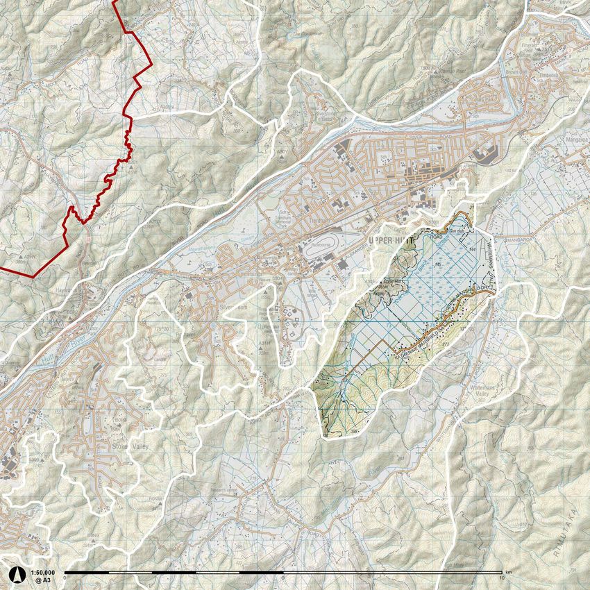
3

                                  HUTT LANDSCAPE STUDY - CHARACTER AREA DESCRIPTION
HUTT
LANDSCAPE STUDY
                    2012
Landscape Character Description
APRIL 2012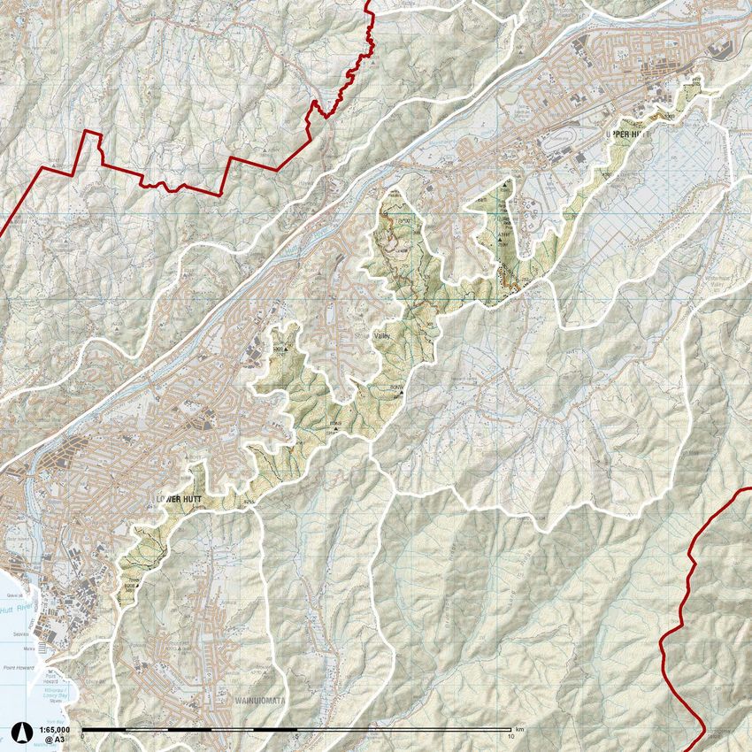
4
HUTT LANDSCAPE STUDY - CHARACTER AREA DESCRIPTION
CONTENTS
                                                                         5

                                                                 HUTT LANDSCAPE STUDY - CHARACTER AREA DESCRIPTION
       SECTION A: BACKGROUND							7
       BACKGROUND											8
       METHODOLOGY										9

       SECTION B: LANDSCAPE CHARACTER DESCRIPTIONS          15
       BROAD LANDSCAPE TYPES									16
       HUTT CHARACTER AREAS									22
       HUTT VALLEY 											24
       WESTERN ESCARPMENT 									26
       EASTERN HUTT HILLS										28
       KAITOKE BASIN										30
       MANGAROA VALLEY										32
       WALLACEVILLE SWAMP									34
       WHITEMANS VALLEY										36
       WAINUIOMATA BASIN									38
       MOORES VALLEY										40
       WAINUIOMATA VALLEY									42
       GOLLANS VALLEYS 										44
       WELLINGTON HARBOUR									46
       EASTERN BAYS											48
       SOUTH COAST											50
       BELMONT HILLS										52
       MOONSHINE BASIN										54
       WHAKATIKEI HILLS										56
       AKATARAWA VALLEY										58
       HUTT HEADWATERS										60
       RIMUTAKA RANGES										62
       BIBLIOGRAPHY										64

       APPENDICES										67

       APPENDIX 1: MAORI HISTORY                            68

       APPENDIX 2: EUROPEAN HISTORY AND SETTLEMENT          70

       APPENDIX 3: IDENTIFIED HERITAGE SITES                72

       APPENDIX 4: GEOLOGY                                  74
       APPENDIX 5: GEOPRESERVATION SITES							76
       APPENDIX 6: SOILS										78

       APPENDIX 7: ELEVATION AND SLOPE                      80
       APPENDIX 8: LANDCOVER AND INDIGENOUS VEGETATION					 84
       APPENDIX 9: SIGNIFICANT NATURAL RESOURCES						86
       APPENDIX 10:PUBLICALLY OWNED AND MANAGED LAND					   88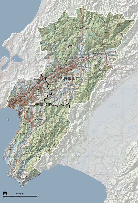
6
HUTT LANDSCAPE STUDY - CHARACTER AREA DESCRIPTION
SECTION A: BACKGROUND
                                                                            7

                        HUTT LANDSCAPE STUDY - CHARACTER AREA DESCRIPTION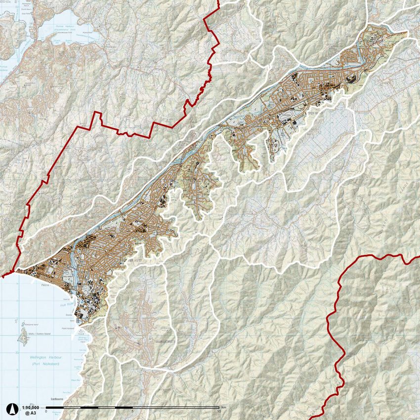
BACKGROUND AND METHODOLOGY
8 INTRODUCTION PURPOSE OF THE HUTT LANDSCAPE
This Landscape Character Description documents stage two of the Hutt STUDY
HUTT LANDSCAPE STUDY - CHARACTER AREA DESCRIPTION
Landscape Study, a comprehensive landscape assessment of the Lower and
Upper Hutt districts. The Hutt Landscape Study has been initiated to assist in the long-term
development of planning measures for managing landscape change in the
The flow chart on the next page shows the study’s structure; each stage Hutt. All landscapes are dynamic; they continually change as a result of
informs the next. The spatial information gathered in Stage One was used natural processes and changing land uses. However, people and groups
for this Stage Two landscape character description. In turn, the character can have conflicting views about the nature and rate of change that is
description can be used as the basis for Stage Three to occur at some time in acceptable in some landscapes, so regional and local councils seek to
the future. enable divergent views to be considered and addressed through planning
provisions.
Policies 24 and 26 in the Proposed Wellington Regional Policy Statement
STUDY AREA (Proposed RPS) require that the region’s outstanding natural features and
landscapes (ONFs and ONLs), and significant amenity landscapes (SALs),
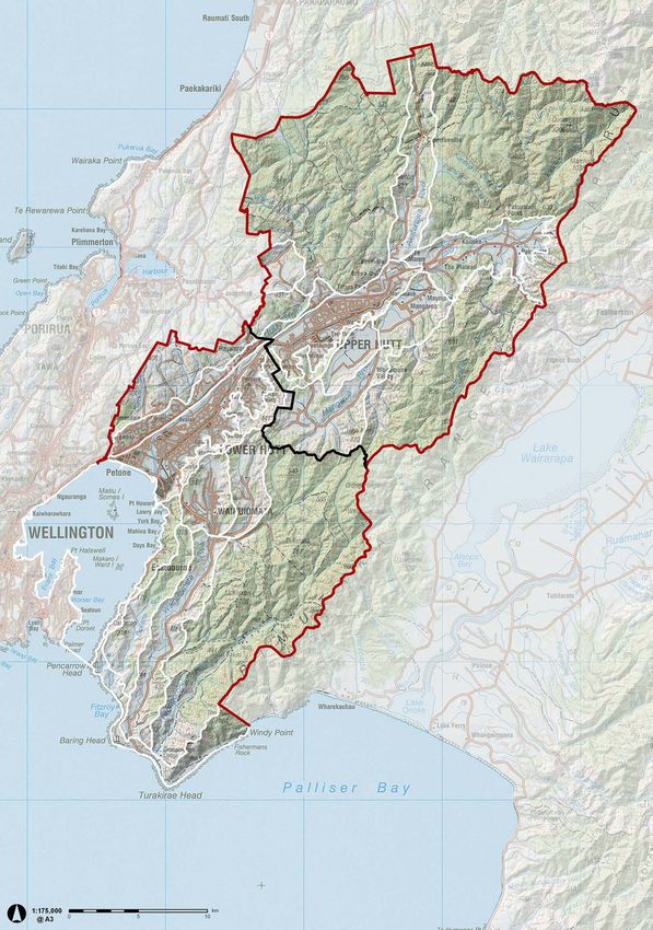
The study area encompasses the combined area of Upper Hutt (UHCC) and be identified in district and regional plans. Neither Upper Hutt nor Hutt
Hutt City (HCC) referred to, for the purposes of the study, as the Hutt (refer City currently identify ONFs, ONLs, or SALs in their respective district plans.
to map, p11). However, since identification of these landscapes will be required under the
operative RPS, this study will provide a solid basis for the identification these
The study area includes urban areas in so far as the extent of urban areas landscapes to be undertaken at some point in the future.
are identified as a generic ‘urban’ character area, but a description of the
urban area is beyond the scope of this report.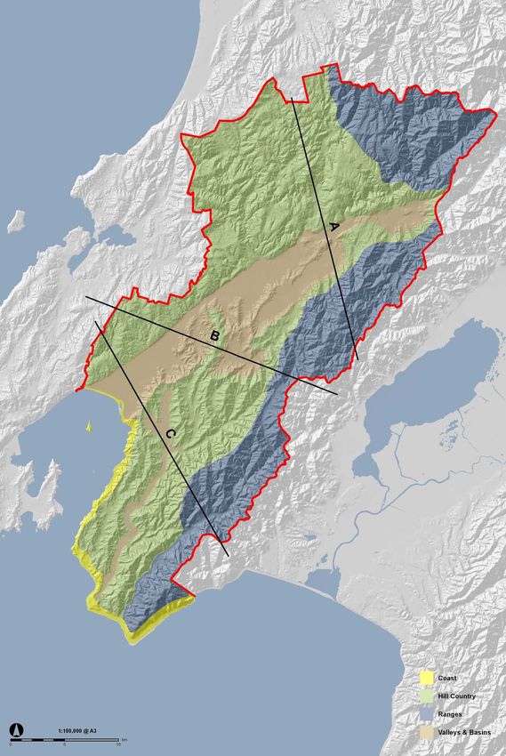
PURPOSE OF THE HUTT LANDSCAPE                                                                Essentially, landscape character is the interrelationship of three broad
                                                                                             factors – landform, land cover and land use. Within these broad factors
                                                                                                                                                                                    9

CHARACTER DESCRIPTION                                                                        there are many variables; for instance, land cover can include a myriad of

                                                                                                                                                                            HUTT LANDSCAPE STUDY - CHARACTER AREA DESCRIPTION
                                                                                             vegetation types and built forms. The way these varied factors combine
                                                                                             produces areas of distinctive character. As with most regional and district
In the proposed RPS, one of the methods for implementing policies 24                         landscape studies, the Hutt Landscape Study classifies the study area into
and 26 (mentioned above) is method 49, which requires the Wellington                         a series of landscape character ‘areas’, by analysing these factors. It is a
Regional Council, together with city and district councils, to: “Develop and                 pragmatic approach which enables the complexity of often extensive and
disseminate a regional landscape character description that describes and                    highly diverse areas of land to be described in a way that communities can
categorises the region’s landscapes to assist with identifying outstanding                   readily recognise.
natural features and landscapes, and significant amenity landscapes.”

The overall purpose of method 49 is to provide a comprehensive and
consistent inventory of the region’s landscapes for local authorities to use
as the starting point for implementing policies 24 and 26. This Landscape
Character Description document provides the landscape inventory for the
Upper Hutt and Hutt city. As stated earlier, its purpose is to provide the basis
for identifying outstanding natural features and landscapes, and significant
amenity landscapes, in later evaluation stages.

WHAT IS LANDSCAPE CHARACTER AND
CHARACTERISATION?
Landscape character ‘is derived from a combination of land form, land cover
and land use that makes one area different from another, rather than better
or worse.1 Put simply, landscape character is that which makes an area
unique.

New Zealand has been referred to as a land of ‘little landscapes’2 . That is,
there is considerable variation in New Zealand’s landscape over relatively
short distances and areas. These ‘little landscapes’ are distinct from one
another and they more often than not occur in regional patterns. Within a
region, communities identify with ‘their’ landscapes and often refer to them
as having a particular combination of attributes and features that give them
a distinctive ‘character’ 3.

Understanding landscape character is important because landscape
character not only influences how we interact with and feel about the
places where we live, work and play – it influences our culture and our
imaginations. Conversely, we seek to shape the landscape to meet our
needs. It is by paying proper regard to the existing character of our
landscapes that informed and responsible decisions can be made regarding
their management. We can endeavour, through understanding how places
differ, to ensure that future development will be sensitive to location, and
will contribute to environmental, social and economic objectives4.

‘Landscape characterisation’ is the term used for the process of identifying,
mapping and describing character areas. Each character area has a
distinguishing combination of biophysical and cultural factors that makes
it distinctive from adjacent character areas. Characterisation provides a
sound descriptive and analytical basis for the understanding of landscape
diversity and change; it also provides a context for the evaluation of ‘special
landscapes’ such as outstanding natural landscapes and significant amenity
landscapes. In turn, the recognition of these special landscapes provides
the basis and justification for managing them in a particular way.

Scientists and other specialists such as geologists, ecologists and
climatologists, categorise the landscape for different purposes relating to
their specific disciplines and there is a wealth of information available from
their work. Landscape characterisation draws upon that work, aiming to
bring it together in a way that is meaningful to non-scientific people and
relating it to the way people experience the landscape.

1 Landscape planning definitions discussed and agreed to by senior Boffa Miskell Landscape
Architects March 2011
2 pp33-41, Our Changing ‘Natural’ Landscapes, by John Hayward, & Kevin O’Connor. in New
Zealand, Where are You?(1981), Wellington, New Zealand Institute of Landscape Architects.
3 Ibid
4Landscape Character Network web site. www.landscapecharacter.org.uk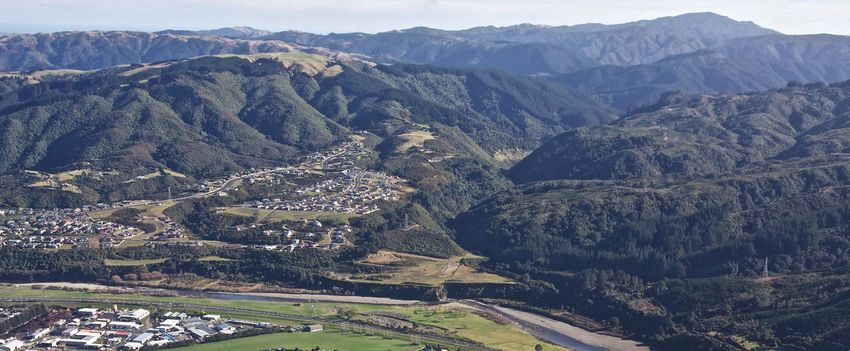
STAGE 1:
           10                                                           WELLINGTON                        GIS database of the region’s spatial landscape
                                                                         REGIONAL                                          information
                                                                      LANDSCAPE ATLAS
HUTT LANDSCAPE STUDY - CHARACTER AREA DESCRIPTION

                                                                       COMMISSIONED BY GWRC

                                                                                                 Partial implementation of Method 49. Database completed April 2009 and available for use in Stages 2 & 3

                                                                                                                              GIS analysis

                                                                           STAGE 2:
                                                    CURRENT PROJECT

                                                                                                            Desktop review aerial photography, research
                                                                      HUTT LANDSCAPE                                  background documents
                                                                        CHARACTER
                                                                       DESCRIPTIONS
                                                                                                                              Field survey
                                                                        ‘THIS DOCUMENT’

                                                                       COMMISSIONED BY GWRC
                                                                                                            Identification of landscape character areas,
                                                                                                                     mapping and descriptions

                                                                                                                                                                          Verification of character
                                                                                                                                                                          descriptions by Steering
                                                                                                                                                                          Group and stakeholders

                                                                                                            Finalise landscape character descriptions

                                                                                                                                                               Implementation of method 49 completed

                                                                           FUTURE
                                                                           STAGES:                          Assess, identify and recommend proposed
                                                                       RECOMMENDED                       outstanding natural features and landscapes and
                                                                      ONL/ ONF AND SALS                          significant amenity landscapes
                                                                      TO BE UNDERTAKEN BY UHCC
                                                                              AND HCC

                                                                                                                                                         Implementation of Policies 24 and 26 completed

                                                                      FUTURE STAGES
                                                                                                        Development of objectives, policies and rules and
                                                                                                               incorporation into the district plan
KĀPITI COAST DISTRICT
11
HUTT LANDSCAPE STUDY - CHARACTER AREA DESCRIPTION
PORIRUA CITY
UPPER HUTT CITY
WELLINGTON
CITY
HUTT CITY
SOUTH WAIRARAPA DISTRICT
DISTRICT BOUNDARIES12 HOW WILL THE LANDSCAPE LANDSCAPE DESCRIPTION
CHARACTER DESCRIPTION BE USED? METHODOLOGY
HUTT LANDSCAPE STUDY - CHARACTER AREA DESCRIPTION
The landscape character description will be used as a basis of the evaluation The methodology for carrying out the Hutt Landscape Study is summarised
phase of the study (refer to flowchart, p9). The evaluation phase involves in the flow diagram shown on page 9. The different stages and various steps
the use of value judgements that are required to identify and assess involved are shown. Stage One, the collation of spatial information within
outstanding natural features and landscapes, and significant amenity the Wellington Regional Council’s geographic information system (GIS)
landscapes. database, was carried out in 2009.
The landscape character descriptions can also be used in a number of other Stage Two, (this landscape character description) has involved the following
ways, including: steps:
• Providing a spatial framework for helping to develop district-wide • analyse the landscape through review of GIS data, maps, aerial and
policy in documents such as the District Plan, the Long Term Council land-based photographs, and field survey;
Community Plan or Long Term Community Consultation Plan; • identify character areas and their boundaries;
• Providing a resource document about the Hutt landscapes to assist • map the landscape character areas; and
landowners/applicants in preparing assessments of environmental • describe each character area objectively.
effects (AEEs) and resource consent applications;
• Helping to assess development potential (i.e. identifying appropriate
areas for managed development / growth on the urban fringes and in In describing each character area, the aim is to create a mental image of
rural environments); that area through words, maps and photographs – and evoke a sense of
• Informing the siting, scale and design of particular types of what sets that area apart from any other.
development, such as rural residential development, wind farms,
industrial areas etc; The descriptions mention sites or features within landscape character areas
• Contributing to landscape capacity studies, to identify areas suited to that are significant components of the wider landscape, such as a geological
the supply of land for housing, rural activities and forestry use; formation, a stand of native forest, a stretch of coastline or an historic
• Providing spatial information relevant to ensuring that local policies feature. These sites and features have often been identified by various
and practices are consistent with regional and national policy specialists as having some particular importance. Communities, too, identify
initiatives;
with them and seek to recognise them in some way – through naming them,
• Providing a base line against which future landscape change and the
featuring them in art and literature, or assigning them a special status or
effect of landscape protection and management measures in the
district plan can be monitored; protection.
• Informing work on special areas, such as mapping and the rationale
It should be noted, however, that the descriptions are not intended to assign
for having special policies for those areas.
value to sites, features or character areas. That will be addressed in future
stages which would seek to evaluate landscapes. Nor will any particular
courses of action be prescribed at any stage of the study in terms of value or
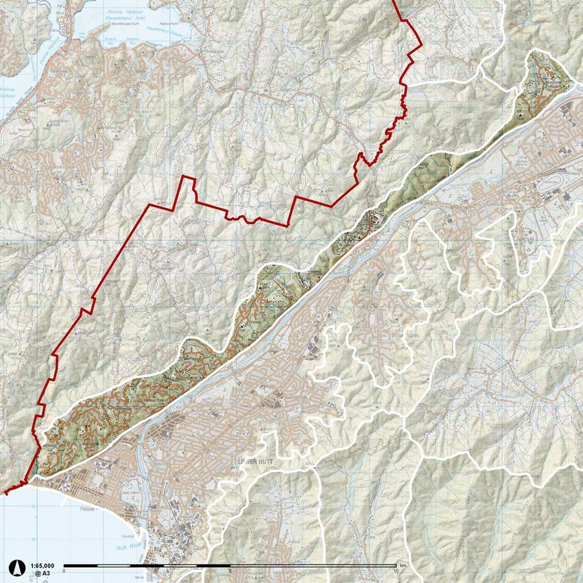
how areas should be managed.MAPPING LANDSCAPE CHARACTER DATA SOURCES 13
AREAS
HUTT LANDSCAPE STUDY - CHARACTER AREA DESCRIPTION
Landscape character areas are mapped to communicate their location and Use of spatial data through geographic information systems (GIS) has
general spatial extent. However, the varied factors discussed above that been integral to this study. GIS is a powerful tool used for analysing,
distinguish one character area from another do not conveniently stop and visualising and mapping spatial and non-spatial digital geographic data.
start at a particular point or boundary. Consequently the mapping lines GIS systematically organises graphic data to enable a person reading an
should be considered as ‘zones of transition’ rather than precise lines that electronic map to select or deselect specific information about the area
mark absolute points of change between adjacent character areas. under review.
Data from Greater Wellington Regional Council’s Wellington Region
The boundaries for this character study are mostly based on topographical Geodatabase5, was the primary source of data for this study. The
features such as the tops of escarpments, ridgelines or hills, or waterways. geodatabase was commissioned specifically for the landscape
Ridgelines form natural boundaries to visual catchments (as experienced characterisation description project, prescribed in Method 49 of the
from the valley floors) and, as such, are often logical boundaries for Wellington Regional Policy Statement to be undertaken throughout the
character areas, but that is not to say every ridgeline is a boundary to region.
a character area. Nor is the top or bottom of a ridge or hill always the
boundary for a character area; in some locations, such as where the plains The maps from the Wellington Region Geodatabase used in this study
adjoin the hills, the toe and lower slopes of the hills have been included in are: Geology, Geopreservation Sites, Soils, Elevation, Slope, Identified
the plains character areas because they are an integral part of those local ‘protected’ natural areas, Identified Maori Cultural and Heritage Sites, and
environments. topographical features.
As noted earlier, urban areas are considered as part of the character area in The maps presented in this report, based on sources other than Wellington
which they occur. Region Geodatabase are:
Each of the character areas has been assigned a simple name. These are • Zoning - GIS layers provided by Hutt City and Upper Hutt City Councils
simply labels to distinguish one character area from another; there has been • Land Cover - Land Cover Database, version 2 (LCDB 2, 2001) from
no attempt to assign names that encapsulate the full extent of all localities Terralink;
in each character area. For example, the Gollans Valley character area • Land Types - mapped by Landcare Research and digitised by Boffa
Miskell Limited;
extends further than just that catchment but the label will assist people to
• Cultural, Heritage & Archaeology - GIS layers provided by Hutt City
visualise the general geographic location of the character area. and Upper Hutt City Councils from district plan registers;
• Regional Parks - GWRC, DoC;
• Landscape Character Areas - created by Boffa Miskell Limited.
These maps, together with a brief description of each map are included in
Appendices 3-10 at the end of this report. Further information and details
on each map can be obtained by interrogating the datasets in the Wellington
Region Geodatabase.
Appendices 1 and 2, contain a brief outline of the Hutt’s Maori and
European history, and settlement patterns.
5 Wellington Regional Landscape Atlas Prepared by Isthmus Group for Greater
Wellington Regional Council, May,2009.14 HUTT LANDSCAPE STUDY - CHARACTER AREA DESCRIPTION
CHARACTER DESCRIPTIONS
   SECTION B: LANDSCAPE
                                                                              15

                          HUTT LANDSCAPE STUDY - CHARACTER AREA DESCRIPTION
BROAD LANDSCAPE TYPES
This section begins with a description of each of the four broad landscape The group described as “Valleys/Basins” includes areas where alluvial
16
types in the Hutt followed by descriptions of each of the 20 landscape deposits have formed relatively flat land. The largest of these being the
character areas. Each landscape character area description includes a map, lower and upper parts of the Hutt Valley. Secondary valleys/basins include:
photographs, narrative and a summary of key landscape characteristics. Mangaroa basin, Whitemans Valley, the lower Akatarawa River flats and the
HUTT LANDSCAPE STUDY - CHARACTER AREA DESCRIPTION
upper Wainuiomata Valley.
The Hutt comprises four broad, readily identifiable landscape types:
The “Coast/Harbour” includes approximately 40km of coastline from
• Ranges Korokoro Stream at Petone to Windy Point in Palliser Bay. This landscape
• Hill Country type includes the harbour and three Islands; Matiu/Somes Island, Mākaro/
• Valleys/ Basins Ward Island and Mokopuna Island.
• Coast/Harbour
The cross sections A, B and C show the contrasting topography across the
main axis of the Hutt Valley
The “Ranges” area is almost entirely in public ownership and management,
and comprises the steep, high land which encloses the Hutt to the north and
east.
The area described as “Hill Country” occurs on the raised terrace lands
which have been elevated by repeated uplifts. These landforms have
subsequently eroded and warped by glacial, hydrologic forces and repeated
tilting and uplifts to form the dissected moderately steep to rolling
topography which characterises the hill country.
ER
IV
R
Y/
Y
LE
RY
LE
ER
7M
L
2M
L
DA
IV
VA
VA
62
IR
86
UN
A
A
ON
AW
UN Y AH
RO
UA
IE
BO
RY
IM
RT
BO UD AT
AR
GA
AR
DA
Y
BA
CL
ST KU R
AT
UD
M
AN
T
AK
T
TE
ST
M
PA
M
M
EXAGGERATED PROFILE
800m
600m
400m
200m
0m
0m 500 1000
HILL COUNTRY VALLEY/ BASIN VALLEY/ BASIN VALLEY/ BASIN RANGES
SECTION A
/
GI
AN
5M
Y
Y
LE
LE
RY
RY
IR
7M
38
L
L
A R A
VA
VA
DA
DA
Y
IT E K
71
A
LE
RU
UN
TA RIV WA
UN
S
S
TY
L
AN
AN
VA
GI
BO
BO
T T TE A
IS
M
M
N
SH N
M
ES
TA
TE
TE
Y
O
Y
UD
GH
UD
OK
H U 2/
LS
HI
HI
AI
KE
ST
ST
W
HI
ST
W
W
EXAGGERATED PROFILE
800m
600m
400m
200m
0m
0m 500 1000 HILL COUNTRY VALLEY/ BASIN HILL COUNTRY VALLEY/ BASIN RANGES
SECTION B
I/
RY
G
R
DA
AN
VE
RI
UN
IR
6M
5M
OB ER KA
O
BO
S
A
A
70
NG
LE
W
AT
AT
33
V A
HE
EA
DA
W
RI W
RO
M
M
ER
TT E A
RO
AR
T
T
AN
N
IO
IO
GO
1M AT
ON
TH
UR
ER
NU
NU
T
Y
RM
94 T M
ON
OW
LM
H U 2/
UD
CK
AI
AI
SH
NO
OR
M
ST
BE
W
M
CR
W
W
EXAGGERATED PROFILE
800m
600m
400m
200m
0m
0m 500 1000
HILL COUNTRY VALLEY/ BASIN HILL COUNTRY VALLEY/ BASIN RANGES
SECTION CBROAD LANDSCAPE TYPES
17
HUTT LANDSCAPE STUDY - CHARACTER AREA DESCRIPTION
PHOTOS
AND TEXT
1:175 000 @A318 RANGES
Approximately 31% of the total land area in the Hutt consists of elevated The steepness of the hills being formed by ongoing uplift and the weak
HUTT LANDSCAPE STUDY - CHARACTER AREA DESCRIPTION
steeplands or ranges, and the majority of it is publicly owned and/or nature of the greywacke rock which underlies most of the Wellington region
managed. This area includes parts of the Tararura and Rimutaka Forest predispose the ranges to high rates of erosion. This is compounded by the
Parks, the Hutt Water Collection Areas, Pakuratahi Forest, and four Water climatic extremes experienced throughout the area and the effect of the
Collection Areas. climate on plant growth and distribution.
Tectonic and glacial processes have been pivotal in forming the ranges, The steeplands in the vicinity of the Hutt Water Catchment Area (Tararua
whilst climatic conditions have determined the nature of current land uses Range) are some of the steepest and highest in the Hutt, with peaks of
and the distribution of vegetation. 1000m - 1360m. The Pakuratahi and Wainuiomata/Orongorongo steeplands
which adjoin the Rimutaka Ranges are somewhat lower with peaks around
The topography of the ranges is a result of continual geological uplift and 700-900m.
rapid downcutting of stream systems through highly fractured bedrock
material. The marked northeast-southwesterly orientation of the valleys and The vulnerability of steepland soils to erosion is described as high to severe,
ridges throughout the ranges reflects the texture of the wider lower North but actual erosion is described as negligible if the vegetation cover is
Island landscape, resulting from the numerous faults which traverse the area undisturbed. The land use classification for steepland areas predominately
in this direction. falls within classes 6, 7 and 8 which indicates that there are major limitations
on their productive use.
The Tararua and Rimutaka Ranges enclose the northern and eastern sides
of the Hutt. These ranges are recent geological features created in the last Large areas of the steeplands still have original tracts of native vegetation,
2-3 million years by the uplift and faulting of old and brittle greywackes and including some of the least modified forests in the region. In all these forests
argillites. Several of the faults are still considered to be active. The most the key threat has been browsing by deer, goats and possums. The Hutt
recent significant activity was the 1855 movement of the West Wairarapa Water Collection Area includes extensive areas of silver beech and red beech
fault which tilted the entire Wellington Peninsula, lifting the southern end forest which has not been modified, the largest areas of alpine tussocklands
of the Rimutaka Ranges 6 metres and raising the Hutt Valley 1.8 to 2 metres. in the region, and the only alpine wet turf and subalpine sphagnum bog
This earthquake created extensive slips throughout the Rimutaka Ranges, contained on Greater Wellington land. The Hutt Water Collection Area
particularly in the Orongorongo valley and increased the fall of Te Awa is one of the few areas in the region containing southern rata, a species
Kairangi/Hutt River and its tributaries. Uplift is occurring in the Rimutakas at endangered in the region by possum browsing.
an average rate of 4m per 1,000 years.
The Rimutaka Ranges provide a dramatic backdrop to much of the Hutt Valley.HILL COUNTRY 19
HUTT LANDSCAPE STUDY - CHARACTER AREA DESCRIPTION
Hill country makes up the largest proportion of the Hutt study area forest for timber and with the intention of the land being farmed in the early
(50%). The hill country includes the steep to rolling hills; an intermediate 1900s. However, the land was found to be unsuitable for intensively grazed
topography between the steeper, more elevated ranges and the low lying pasture. As a result, large portions have been left to revert to gorse and
valleys/basins. The hill country has been typically formed from the remains native shrubland. The lower and more gentle toe slopes that enclose the
of uplifted river terraces and old floodplains which have been elevated by valleys and basins in close proximity to urban areas, have come under recent
200m or more over the last 500,000 years. These alluvial deposits have development pressure — predominantly for lifestyle blocks, or residential
subsequently weathered by a combination of ice, wind and water to form development.
the dissected steep to rolling hill country.
Whilst the hill country has limited agricultural uses, the rock and gravel
Hill country throughout the Hutt is typically elevated around 200-400m resource is valuable and there are a number of abandoned and operational
asl but there is much variation within this broad landscape type. The most quarries along the Wellington Fault escarpment.
elevated hill country is the Whakatikei Hills which are around 700m on
the western margin, although they are generally around 430m in height Current landcover on the hill country is a diverse mix of exotic and native
elsewhere. Although the Whakatikei Hills have some similarities with the vegetation. The majority of the hill country supports native forest remnant,
‘ranges’ they are significantly lower and more accurately described as hill regenerating native forest, exotic and native scrub and production forestry.
country. There are four main areas of ‘hill country’ the Belmont/Hayward Less than half of all grazed land in the Hutt occurs within the hill country
Hills, the hills surrounding Wainuiomata, coastal hills which form a backdrop area.
to the narrow coastal platform, and the Southern Hills (between Upper Hutt
and Mangaroa/Whitemans Valley).
In contrast to the steep and jagged ridges of the hill country north and
west of the Hutt Valley, the Belmont Hills to the west are more rounded.
The broad and undulating ridgetops of the Belmont Hills are a remnant of
an uplifted gravel capped plain (peneplain). The sides of the uplifted block
have, over millions of years, been smoothed through erosion into a series of
steep gullies and valleys.
The steepness and poor soil quality makes much of the hill country of
limited agricultural use. Large areas of the hill country were cleared of native
The uplifted flood plains of Riverstone Terraces provide a flat area for recent residential development.20 VALLEYS AND BASINS
HUTT LANDSCAPE STUDY - CHARACTER AREA DESCRIPTION
Valleys and basins includes the flat parts of the Hutt and the low hills/slopes The urban areas are located primarily within the central Hutt Valley, and
that enclose them. The main valleys and basins are the Hutt Valley with occupy a large proportion of the flat valley floor. Smaller pockets of urban
Stokes and Silverstream side valleys, as well as secondary valleys such as and rural-residential development are also located in the secondary basins
Mangaroa, Whitemans, Kaitoke and Wainuiomata. The valleys and basins and valley floors, such as Stokes, Mangaroa and Wainuiomata Valleys.
comprises approximately 17% of the total land area in the Hutt Valley.
Although detailed landcover data for the basins is not available, it generally
The flat fertile soils in these areas have been gradually built up by gravel consists of a mix of exotic and native plantings (local reserves, lawns, playing
and sediment deposits distributed by rivers and streams. Valleys such as fields, private gardens, street trees etc) set within an urban framework.
Wainuiomata and Mangaroa were formed as the entire landscape east There are few sizeable indigenous remnants and no regional forest parks
of the Wellington fault was tilted downwards toward the west. As the located within the basins. The few exceptions are Grants Bush on the
tilting progressed, stream gradients became flattened or actually reversed Wallaceville campus and Bartons Bush at Trentham Memorial Park, Upper
resulting in the buildup of headwaters and the formation of extensive areas Hutt. However, on the whole, only a few scattered ecological sites of
of swamp and peat. Historically vegetation in these swampy depressions significance remain, mostly in private ownership.
would have been primarily kahikatea/black beech/maire swamp forest, peat
Te Awa Kairangi/Hutt River has been instrumental in forming the central
bogs with manuka and sphagnum. Totara dominated forests on excessively
Hutt Valley and in determining the pattern and distribution of early
drained gravel terraces. There would also have been an abundance of
settlement of the valley. Despite the extent of current urbanisation in the
podocarps, hinau, tawa and beech depending on local drainage and fertility.
lower sections of Te Awa Kairangi/Hutt River it remains in surprisingly good
Intact wetlands are extremely poorly represented in the Hutt and much condition due largely to its extensive forested headwaters. The continued
reduced from previous times. A wide range of indigenous flora and fauna health of this river relies on the wise management of these headwaters.
relies entirely on wetlands and lake margins and this biota is subsequently The main threats to Te Awa Kairangi/Hutt River and its wildlife are pollution
absent from the Hutt. from industrial waste, sedimentation from land clearance and forestry, and
disturbance of migratory fish passage by damming, diversion or channelling.
The fertile soil on the basin floor at Kaitoke was once covered in podocarp forest but is now mainly in pasture.COAST 21
HUTT LANDSCAPE STUDY - CHARACTER AREA DESCRIPTION
The coast (including the islands) comprises approximately 2% of the total The three islands within Wellington Harbour are the remains of a now
land area in the Hutt Valley. It is a distinctive landscape type that occupies submerged valley system. The islands have mainly rocky shores. Matiu/
the narrow fringe of land along the coastline and comprises uplifted marine Somes Island is the biggest island, encircled by high cliffs primarily covered
terraces, escarpments which rise steeply from the coastal platform, alluvial in salt tolerant indigenous vegetation.
fans resulting from the deposition of gravel from the rivers that dissect the
The vegetation patterns around the coast are strongly influenced by the
escarpment, coastal lakes and both rocky and sandy beaches.
exposure to the strong salt-laden winds and comprises hardy coastal
The varied geological history of the coast is obvious. During interglacial shrubland species. At higher elevations patches of red and silver beech
periods, the sea level was much higher and the marine terraces that formed and kamahi occur on the escarpments, although in many areas of the
during these times are evident in places, particularly between the mouths of escarpment the large scree and shingle slopes are absent of any significant
the Orongorongo and Wainioumata Rivers, and around Baring Head. Seismic woody vegetation. Within Wellington Harbour, along the eastern side, the
activity has also played a significant role in the formation of the coastal vegetation comprises of coastal shrubland species, with lowland beech
environment. The most significant in recent times being the earthquake of species occurring on the hills further north towards Petone.
1855 which raised the southern end of the Rimutaka range, including the
Along the coast archaeological sites such as middens, pits and pa sites
adjacent beaches, by approximately 6m. However this earthquake was just
provide evidence of early Maori who used the coast as a route into the
one of many. Earlier seismic events raised the beaches along the coast on
Wairarapa. Early Europeans also accessed the Wairarapa via the coast,
several occasions. These ancient beaches are visible along the raised coastal
and used the coastal platform to drive stock between Wellington and the
platform as a slight ridge with a rocky sea bed exposed below them.
Wairarapa.
Seismic activity has also resulted in the formation of the two coastal lakes
Orongorongo Station, established in the early days of European settlement,
(Kohangapiripiri and Kohangatera) that are situated between Baring Head
occupies the coastal platform around much of the exposed south coast and
and Pencarrow Head. Once tidal inlets, these lakes have been cut off from
extends up the Orongorongo Valley. Most of this land is grazed and consists
the sea by the raising of the coastal platform that resulted from these
of rough pasture and exotic and native scrubland species.
earthquakes.
Since the early days of European settlement, the Eastern Bays have been a
Within Wellington Harbour Te Awa Kairangi/Hutt River has played an
popular recreation destination for Wellingtonians. They are easily accessible
important role in the formation of the coastline around the Eastern Bays.
by road from the Hutt Valley or via ferry from Wellington, and residential
Sediment from the river, and to a lesser extent the smaller, Korokoro Stream,
dwellings are located on much of the flat land and some of the lower hill
has been deposited along the eastern coast creating sandy beaches and a
slopes.
350m wide area of flat land. Within the Wellington Harbour, Petone is the
only other significant area of sandy beach. It also formed by the deposition
of sediment from Te Awa Kairangi/Hutt River.
The marine terraces that were formed at times when the sea level was much higher are evident here between Baring Head and Turakirae Head.HUTT LANDSCAPE CHARACTER AREAS
22 HUTT VALLEY 24
WESTERN ESCARPMENT 26
EASTERN HUTT HILLS 28
HUTT LANDSCAPE STUDY - CHARACTER AREA DESCRIPTION
KAITOKE BASIN 30
MANGAROA VALLEY 32
WALLACEVILLE SWAMP 34
WHITEMANS VALLEY 36
WAINUIOMATA BASIN 38
MOORES VALLEY 40
WAINUIOMATA VALLEY 42
GOLLANS VALLEY 44
WELLINGTON HARBOUR 46
EASTERN BAYS 48
SOUTH COAST 50
BELMONT HILLS 52
MOONSHINE BASIN 54
WHAKATIKEI HILLS 56
AKATARAWA VALLEY 58
HUTT HEADWATERS 60
RIMUTAKA RANGES 62
PHOTOS
AND TEXT23
HUTT LANDSCAPE STUDY - CHARACTER AREA DESCRIPTION
HUTT
HEADWATERS
WHAKATIKEI HILLS
AKATARAWA
VALLEY
KAITOKE BASIN
MOONSHINE
BASIN
UPPER HUTT CITY DISTRICT
MANGAROA
VALLEY
HUTT VALLEY
WALLACEVILLE
BELMONT HILLS SWAMP
RIMUTAKA
RANGES
EASTERN WHITEMANS
WESTERN HUTT HILLS VALLEY
ESCARPMENT
MOORES
VALLEY
WAINUIOMATA
BASIN
EASTERN HUTT CITY DISTRICT
BAYS
WELLINGTON
HARBOUR RIMUTAKA
RANGES
GOLLANS
VALLEY
WAINUIOMATA
VALLEY
SOUTH
COAST
HUTT LANDSCAPE CHARACTER AREASHUTT VALLEY
24 The Hutt Valley character area includes the Hutt Valley floor and the lower the Regional Council as part of river management line most of the river
portion of the slopes to the east. It extends from the Petone shoreline banks, while stop banks and areas immediately adjoining are mainly mown
in the south-west to Emerald Hill in the north-east. The area is bounded grass, with flax and other native vegetation in places.
on the north-west by the Wellington fault escarpment and Belmont Hills
HUTT LANDSCAPE STUDY - CHARACTER AREA DESCRIPTION
beyond. A series of hill systems, rising to peaks of up to 441m asl with steep
slopes, enclose the valley on the south-east. SH2 runs along the south-west
boundary of the character area following the Wellington fault line and Te
Awa Kairangi/Hutt River.
Te Awa Kairangi/Hutt River is the dominant element of this landscape
character area, and in combination with the Wellington fault has been
instrumental in the formation of the entire valley. Te Awa Kairangi/Hutt River
enters this character area at Birchville, where it flows south west and enters
Wellington Harbour at Petone.
Prior to the earthquake in 1855, Te Awa Kairangi/Hutt River remained on the The Petone foreshore forms the south-western boundary of the character area.
north-west side of Gear Island before entering the harbour. However, uplift
resulting from this earthquake altered the lie of the land to such an extent
that the river changed course, rendering the previously navigable river
impassable.
At the time of European arrival, swampy marshlands extended several
kilometres up the valley from the river mouth. Wetland species such as
raupo, flax and toetoe dominated. Beyond this marshland, kahikatea, matai,
puketea and rimu forest grew extensively on the valley floor, with totara,
tawa and beech on the hill slopes. Following arrival of Europeans, the
forests were milled for timber and to make way for farming, while attempts
were made to make the swampy land suitable for habitation.
Most of the valley floor has been cleared of the original forest cover and
other native vegetation with only a few small remnant stands and trees
interspersed in some of the older residential areas remaining, particularly
around the lower Silverstream valley.
Residential development, which covers approximately 59% of this character
area, occupies much of the flat valley floor and also the floors of both the
Stokes and Silverstream Valleys; in places, this development also extends
up the lower hill slopes. The largest areas of flat land which remain
undeveloped for urban/residential use are Te Awa Kairangi/Hutt River Large stop banks have been built along the river to prevent flooding. This creates a
corridor and the areas that includes Rimutaka Prison, Trentham Military significant area of open space around the river that is undeveloped and serves as an
important recreational resource for residents of the Hutt Valley.
Camp and Trentham Racecourse, St Patricks College Silverstream and the
former Agresearch campus at Wallaceville.
The Gracefield and Seaview areas, close to the harbour, were historically
home to many large industries such as car manufacturing, railway
workshops, wool scours and mills and soap, tobacco and biscuit factories.
While, most of these large industries have closed, Gracefield and Seaview
remain the main industrial areas in Lower Hutt. Commercial zoning now
covers approximately 17% of this character area.
Control of the flooding of the river has been ongoing since European
settlement, and has included channel realignments, removal of gravel,
construction of flood banks and reinforcement of banks through the
planting of willow. Large stop banks prevent flooding of the residential and
urban areas that now cover much of the valley floor. The land between the
stop banks and the river are free of development and provide an important
open space and recreational resource for the residents of the Hutt Valley
including the Hutt River Trail and several golf courses. Willows planted by
Land that was once swampy marshlands is now covered in residential developmentAKATARAWA VALLEY
25
EMERALD HILL
HUTT LANDSCAPE STUDY - CHARACTER AREA DESCRIPTION
UPPER HUTT
TRENTHAM
SILVERSTREAM
STOKES VALLEY
LOWER HUTT
GEAR GRACEFIELD
ISLAND
PETONE
SEAVIEW
WELLINGTON
HARBOUR
HUTT VALLEY
Te Awa Kairangi/Hutt River now enters Wellington Harbour to the east of Gear Island, however prior to the 1855 earthquake it entered the harbour on the west side of Gear IslandWESTERN ESCARPMENT
26 The Western Escarpment character area includes the steep escarpment The Western Escarpment, which rises sharply above the Wellington fault line, forms a
on the north-west side of the Hutt Valley from Riverstone Terraces in the distinctive demarcation between the flat valley floor of the Hutt Valley and the Belmont
Hills beyond.
north-east to Petone in the south-west. The Wellington fault line runs along
the north-western edge of the Hutt Valley; the Belmont Hills have gradually
HUTT LANDSCAPE STUDY - CHARACTER AREA DESCRIPTION
been pushed up while the Eastern Hutt hills have gradually been tilted
down, thus creating the Hutt Valley.
The Escarpment’s steepness compared to the surrounding landscape
makes it a very distinctive feature of the Hutt Valley and clearly defines the
valley’s western edge. At a more local scale, the Escarpment is fragmented
by numerous steep gullies that drain the Western Hills, resulting in a
topographically convoluted landscape.
From Kelson south, residential development is prominent. The pattern
of the residential areas has been dictated by the dissected and steep
topography, with development occurring on the higher flatter land, leaving
the steep vegetated gullies and escarpment face undeveloped. At the very
northern end, the recent Riverstone Terraces residential area is perched on a
gently sloping terrace above the valley floor, and is not dissected by gullies.
In the vicinity of Manor Park/Haywards Hill Road there is a cluster
of infrastructure, including operating and closed quarries, Haywards
Substation, transmission lines, water reservoirs and SH58 (Haywards Hill
Road). Further south, in Normandale, is the largest area of suburban
The Escarpment vegetation is primarily regenerating podocarp/tawa forest interspersed
commercial development around Dowse Drive and around Hebden cresent with mature exotic trees (macrocarpa, pine) and patches of gorse.
is an area that is zoned general business.
Residential areas occupy approximately 37% of the character area with the
remainder being ‘undeveloped’. The escarpment generally has a dense cover
of native and exotic woody vegetation, which adds to its distinctiveness
as a landform and as backdrop to the wider Hutt Valley landscape. The
vegetation comprises a mix of mature exotic trees such as macrocarpa and
pine, patches of gorse, small areas of pine plantation, and regenerating
podocarp/tawa forest particularly in the gullies where moist, fertile
conditions have allowed a dense under storey to thrive.
The escarpment between Haywards Hill Road and Riverstone Terraces is the
longest section that is undeveloped. Keith George Memorial Park, on the
escarpment south of the junction of SH2 and Fergusson Drive, is a significant
70ha remnant of tall native forest and provides an indication of what the
escarpment vegetation would have once been like.
Evidence of Maori habitation is present in some places and includes stone Perched on the top of a gently sloping terrace, Riverstone Terraces is the most recently
walls from gardening sites, remnants of mills, and urupa. developed residential area on the Western Escarpment.
As in much of the Wellington Region, wind is frequent and has influenced
the vegetation cover and the way residential subdivision has been
developed; the escarpment is a significant barrier and lifts the wind and
channels it through the gullies.
Around Haywards Hill Road there is a cluster of infrastructure which includes Belmont Quarry and numerous transmission lines.27
HUTT LANDSCAPE STUDY - CHARACTER AREA DESCRIPTION
RIVERSTONE
TERRACES
HA
YW
AR
DS
HI
LL
E
RO
IN
TL
AD
UL
FA
N
G TO
L IN
EL
W
MANOR
PARK
KELSON
2
SH
BELMONT
NORMANDALE
PETONE
WESTERN ESCARPMENT
The Western Escarpment is peppered with residential dwellings that are nestled into the hill slopes.EASTERN HUTT HILLS
28 The Eastern Hutt Hills character area extends from Kingsley Heights (Upper The Eastern Hutt Hills are covered in a mix of gorse, pine plantation and patches of native
forest
Hutt) in the north-east to the Wainuiomata Road in the south-west. It
includes the upper slopes of the hills on the eastern side of the Hutt Valley,
up to a well defined ridge which reaches 441m asl above Stokes Valley. At
HUTT LANDSCAPE STUDY - CHARACTER AREA DESCRIPTION
the southern end, the hills separate the lower parts of the Hutt Valley from
the adjacent Wainuiomata basin and Moores Valley catchments. Further
north, the same line of hills separates Stokes Valley from the head of
Whitemans Valley, and Upper Hutt from Wallaceville Swamp. Further north
again, the Eastern Hutt Hills are much lower (approximately 240m asl) and
separate Upper Hutt city from Mangaroa Valley. The character area also
consists of a number of prominent spurs, including the spur that juts into
the Hutt Valley between Pinehaven and Stokes Valley forming the ‘divider’
between Upper and Lower Hutt.
Originally, the Eastern Hutt Hills would have been covered in dense beech
forest with podocarps, including rimu and kahikatea, on the lower slopes.
However, most of this vegetation was felled for timber to make way for
pasture and market gardens, and later, in the 20th century, urbanisation.
The slopes are now covered in a mix of regenerating indigenous vegetation
including kanuka, lowland beech species and kamahi, although areas of
gorse cover the drier areas such as spurs and north facing slopes. There
The Eastern Hutt Hills provide a distinctive backdrop to the Hutt Valley extending as far as
are also some areas of pine plantation, particularly on the slopes around Petone in the south.
Pinehaven and in places, wilding pines.
The Eastern Hutt hills provide a definitive landscape backdrop to the eastern
side of the valley and together with the western fault escarpment they
provides a distinct sense of enclosure, which characterises the Hutt Valley.
Historically, wild fire has been a problem in the Eastern Hutt hills and
firebreaks have been formed to prevent the spread of fire, however the
number of fires have diminished in recent years.
The area is largely free from any significant development, although there is
a pocket of residential development clustered around Blue Mountains Road.
Several roads (Blue Mountains Road and Wallaceville Road) provide access
between the Hutt Valley and the valleys to the east. Several trig stations
have been located on the high points on the ridge above the Hutt Valley.
Other developments include water reservoirs and a landfill located above
Stokes Valley.
In the south the Eastern Hutt Hills separate the Hutt Valley from the adjacent Wainuiomata
Valley.
In the north the Eastern Hutt Hills separate the Hutt Valley from the adjacent Mangaroa and Whitemans Valleys.UPPER HUTT
29
HUTT LANDSCAPE STUDY - CHARACTER AREA DESCRIPTION
KINGSLEY HEIGHTS
WALLACEVILLE ROAD
WALLACEVILLE
SWAMP
PINEHAVEN
BL
UE
M
OU
NT
AI
NS
STOKES VALLEY
RO
AD
WHITEMANS VALLEY
LOWER HUTT
MOORES VALLEY
WA IN U IO
M
ATA ROA D
WAINUIOMATA VALLEY
EASTERN HUTT HILLS
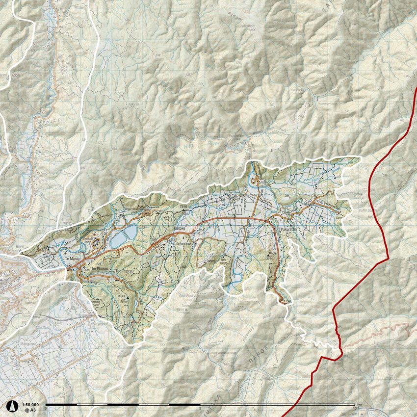
Fire breaks on the main ridges are a distinctive landmark on the Eastern Hills.KAITOKE BASIN
The Kaitoke character area lies at the head of the Hutt Valley. It is a The floors of the basins are ‘subdivided’ by stands of exotic and native trees which create
30 more intimate and enclosed areas.
transitional landscape between Hutt Valley and the Wairarapa and acts as a
gateway to the Rimutaka Hill for travellers on SH2.
HUTT LANDSCAPE STUDY - CHARACTER AREA DESCRIPTION
The character area comprises two elevated basins flanked on either side by
steep slopes. The hills enclosing the basin to the north rise steeply to peaks
ranging between 242m asl and 705m asl. To the south, the basin is enclosed
by a series of more gently sloping spurs separating river and stream valleys.
Te Awa Kairangi/Hutt River has tributaries in the upper Kaitoke basin
(Kaitoke Stream, Farm Creek and Pakuratahi River) and flows through the Te
Awa Kairangi/Hutt River gorge before emerging in the lower basin.
The basins were formed as a result of tectonic activity. As the western hills
of the Hutt Valley were pushed upwards, the Eastern Hutt hills were tilted
downwards at an angle creating the Hutt Valley. The movement of the land
on either side of the fault line has resulted in the buckling of adjacent land
forming a series of humps and hollows. The basins are the hollows that have
resulted from this buckling.
The flat-bottomed floors of the basins are predominantly grazed farmland,
although this is broken up with stands of exotic and native trees which act to
‘subdivide’ the valley floor creating more intimate and enclosed areas. The
slopes on the northern side of the basins are largely regenerating lowland The basin floors are predominately grazed farmland.
beech species and kamahi, while patches of regenerating podocarp forest,
particularly totara and kahikatea, are present on the valley floor. At the
confluence of the Hutt and Pakuratahi Rivers is a stand of remnant podocarp
forest with rimu, rata, hinau and kamahi as well as red beech on the lower
slopes and black beech on the upper slopes. Remnant native forest also
dominates Te Awa Kairangi/Hutt River gorge. Exotic pine plantations and
patches of gorse and manuka cover the slopes leading up to Kaumatua Ridge
and at the end of Plateau Road to the south of the basins.
SH2 runs through this area and provides access into the Wairarapa. Access
into the Mangaroa Valley is also gained via Maymorn Road from Te Marua.
The area around Te Marua was settled by Europeans at least as early as
1820, although Maori inhabited the area before this time with Whakataka
Pa located at the confluence of the Mangaroa River and Te Awa Kairangi/
Hutt River. In recent times, this area remains sparsely populated although
there are enclaves of settlement around the edges of SH2 and at Plateau
Road, where there is a school and a playcentre.
The Stuart Macaskill Storage Lakes which are located in the lower basin
provide about half of Wellington’s water; their size and appearance make Kaitoke Regional Park which lies within this character area provides camping and
recreational opportunities and includes southern access points into the Tararua Forest
them a dominant feature of the basin. Park.
This character area provides several recreational opportunities. Kaitoke
Regional Park (which also includes the Stuart Macaskill Storage Lakes) lies to
the north and in places extends down on to the floor of the basin. The Park
provides camping and walking tracks, with access via Kaitoke Waterworks
Road. Other recreational opportunities in the Kaitoke character area include
Camp Kaitoke, the gliding club, kart track and the shooting range, which are
all accessed from SH2. The Kaitoke character area also includes southern
access points into the Tararua Forest Park. The Pakuratahi Forest provides
access to the Rimutaka rail trail and the historic Rimutaka Incline in the
Wairarapa District, once the steepest section of rail in New Zealand.
The low vegetated hills separate the two basins which comprise this character The Stuart Macaskill Storage Lakes, which are located within Kaitoki Regional Park provide about half
area. of Wellington’s water.31
HUTT LANDSCAPE STUDY - CHARACTER AREA DESCRIPTION
KAIT
TE AWA KAIRANGI/
HUTT RIVER
OKE
WAT
EEK
ERW
CR
M
FA R
ORKS
RD
T R EA M
K A ITO K E S
STUART MACASKILL STATE HIGHWAY 2
STORAGE LAKES
PL
AT
E AU
RD
VER
I RI
E
DG
H
RI
ATA
U A
AT
UR
UM
PA K
KA
RIMUTAKA TRIG
KAITOKE BASIN
Exotic pine plantations and patches of gorse and manuka cover many of the lower slopes and grazed
farm land dominates the floor of the basin.MANGAROA VALLEY
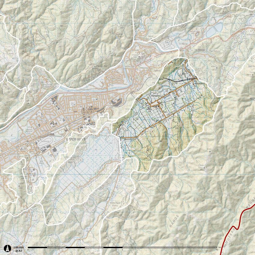
32 Mangaroa Valley is a broad elevated valley located south-east of the Upper
Hutt valley. It is separated from the Upper Hutt valley by a low line of hills
(approximately 200m asl) barely 100m above the floor of the Mangaroa
Valley. Pakuratahi Forest lies immediately to the east of this character area;
HUTT LANDSCAPE STUDY - CHARACTER AREA DESCRIPTION
in places the Forest extends on to the valley floor. South-east of the valley
is Mt Climie, which at 862m asl is the second highest point in the Rimutaka
Range.
The shallow Mangaroa River, with its headwaters in the Whitemans Valley,
meanders south-west to north-east along the valley floor and joins Te Awa
Kairangi/Hutt River at Te Marua.
The valley floor tends to be exposed to less wind than much of the
Wellington region, and can experience heavy frosts in the winter.
The Mangaroa Valley is a clearly defined valley enclosed by steep forested
slopes comprising a mix of regenerating beech and kamahi forest, exotic
scrub and pine plantations. The pine plantations generally occupy the foot
hills and provide an immediate backdrop to the activities on the valley floor.
The valley floor is predominantly grazed pasture broken up by eucalyptus
and pine shelter belts and stands of native and exotic trees. This, combined
with the narrow roads and many barberry hedges, creates an enclosed and
small-scale domesticated landscape. The valley contains a relatively high
density of small rural properties and rural lifestyle blocks. The narrow, quiet
roads of the valley are popular with road cyclists.
As in much of the tributaries of Te Awa Kairangi/Hutt River, the Mangaroa
Valley was logged in the early 1900s. This led to the development of
approximately 50 quarter acre properties around McLaren St at the northern
end of the valley. Once the land was cleared, the valley floor was used for
sheep and dairy farming.
A collection of Defence Department storage buildings located towards the
north of the valley were established during World War II The scale of these
is unfamiliar as they are much larger than would be generally found in a
rural area. A military camp was also established at Maymorn during World
War I.
In the 1950s, the valley was used as a base for workers constructing the
Rimutaka rail tunnel. Several dwellings and other structures relating to this
early history are present at the northern end of the valley, where most of
the settlement is located, including a primary school on Flux Road, which
serves the Mangaroa Valley, and also students from surrounding areas.
Since the arrival of European settlers around the Hutt Valley, the Mangaroa
Valley has been an important farming area. Today, small landholdings of
10ha or less dominate the valley floor, including rural lifestyle lots and small
farmlets; dwellings and associated farm buildings make up the most of the
structures in the valley.
The character of the Mangaroa Valley could change given that Upper Hutt
City Council has recently identified the north-east side of Mangaroa Valley
for urban development. The council has adopted the Maymorn Structure
Plan in January 2012 as part of their Urban Growth Strategy .
The Mangaroa Valley is a broad elevated valley containing a relatively high density of rural lifestyle blocks and is separated from the The narrow roads lined with hedges create an
Upper Hutt valley by a low line of hills enclosed and small-scale domesticated landscape33
HUTT LANDSCAPE STUDY - CHARACTER AREA DESCRIPTION
TE MARUA
R
M AT R E E
VE
S
RI
CL T
O A
AR
AR
F LU
G
EN
AN
XR
M
OA
D
WALLACEVILLE
SWAMP
AY
AM
W MT CLIMIE
L D
RE
IE
SF
ST
AN
K
AC
M
BL
N E
E RI
TH
KA
WHITEMANS VALLEY
MANGAROA VALLEY
Much of the flatland valley is in pasture for farming, while the hill slopes are covered in a mix of regenerating natives, exotic scrub and pine plantation.You can also read