Environmental Assessment Report - Lot 175, 20 Kenhelm Street, Balcatta Charter Hall - EPBC Act
←
→
Page content transcription
If your browser does not render page correctly, please read the page content below
Lot 175, 20 Kenhelm Street, Balcatta

Environmental
Assessment Report
Prepared for

Charter Hall

August 2021
Document                                Prepared           Reviewed            Admin               Submitted to Client
                       Revision
   Reference                                  by                 by               Review             Copies              Date
                                         V. Mugabe N.
                       Internal
  4782AA_Rev0                            Whittington,         T. Smith
                       Draft
                                         C. Walker

                                         V. Mugabe N.
                                                                                                   1x
  4782AA_Rev1          Client Draft      Whittington,         T. Smith           LI                                   05/08/2021
                                                                                                   Electronic
                                         C. Walker

                                         V. Mugabe N.
                                                                                                   1x
  4782AA_Rev2          Client Draft      Whittington,         T. Smith           LI                                   18/08/2021
                                                                                                   Electronic
                                         C. Walker

Disclaimer
This report is issued in accordance with, and is subject to, the terms of the contract between the Client and 360 Environmental Pty
Ltd, including, without limitation, the agreed scope of the report. To the extent permitted by law, 360 Environmental Pty Ltd shall
not be liable in contract, tort (including, without limitation, negligence) or otherwise for any use of, or reliance on, parts of this
report without taking into account the report in its entirety and all previous and subsequent reports. 360 Environmental Pty Ltd
considers the contents of this report to be current as at the date it was produced. This report, including each opinion, conclusion,
and recommendation it contains, should be considered in the context of the report as a whole. The opinions, conclusions and
recommendations in this report are limited by its agreed scope. More extensive, or different, investigation, sampling and testing
may have produced different results and therefore different opinions, conclusions, and recommendations. Subject to the terms of
the contract between the Client and 360 Environmental Pty Ltd, copying, reproducing, disclosing, or disseminating parts of this
report is prohibited (except to the extent required by law) unless the report is produced in its entirety including this cover page,
without the prior written consent of 360 Environmental Pty Ltd.

© Copyright 2021 360 Environmental Pty Ltd ACN 109 499 041

 360 Environmental Pty Ltd
4782AA_Rev1                                               Desktop Environmental Assessment Report
                                                                    Lot 175, Kenhelm Street, Balcatta
                                                                                         Charter Hall

Executive Summary
360 Environmental Pty Ltd (360 Environmental) has been commissioned by Charter Hall to
conduct an environmental assessment for Lot 175, 20 Kenhelm Street Balcatta (the site). This
assessment provides an understanding of the environmental aspects associated with the
development of the site for industrial use.

Vegetation type EmBa covered that covered 0.36 ha has been determined to have affiliation
with Banksia woodlands of the Swan Coastal Plain ecological community, which, is listed as
Endangered under the EPBC Act and as a Priority 3 by the State. For vegetation to be considered
as the Endangered TEC under the EPBC Act and warrant full national protection, the community
has to meet key diagnostic characteristics. Regarding the presence of the TEC, the approved
conservation advice for the thresholds state that for vegetation in Excellent condition, the
minimum patch size should be 0.5 ha. Considering the Banksia woodland vegetation type on site
is 0.36 ha it does not meet the criteria for protection.
A total of four Jarrah (Eucalyptus marginata) trees were recorded as potential breeding trees. A
total 0.66 hectares of foraging habitat was recorded within the site. No evidence of black
cockatoo roosting was observed. There were no direct sightings or calls recorded during the field
survey.
In summary, site contains environmental values that are surrounded by cleared and disturbed
industrial land uses. Due to the small areas and fragmentation of vegetation, the site perimeter
to area ratio is high. Whilst some of the vegetated area is in excellent condition due to the
restricted access, it is likely that over time the quality of vegetation would be degraded from
edge effects would reduce the environmental values of the site.

 360 Environmental Pty Ltd                                                                          i
4782AA_Rev1                                                                            Desktop Environmental Assessment Report
                                                                                                 Lot 175, Kenhelm Street, Balcatta
                                                                                                                      Charter Hall

Table of Contents
1            Introduction .......................................................................................... 4
1.1          Background .................................................................................................................... 4
1.2          Environmental Assessment Objectives ......................................................................... 4
1.3          Scope of Works .............................................................................................................. 4
2            Legislation............................................................................................ 6
2.1          Commonwealth Legislation ............................................................................................ 6
2.2          State Legislation ............................................................................................................ 6
2.3          Relevant Standard, Guidelines and Policies .................................................................. 7
3            Site Environmental Features ............................................................ 10
3.1          Climate ......................................................................................................................... 10
3.2          Surrounding Land Uses ............................................................................................... 10
3.3          Topography .................................................................................................................. 10
3.4          Hydrology ..................................................................................................................... 11
3.5          Environmentally Sensitive Areas ................................................................................. 12
3.6          Flora and Vegetation .................................................................................................... 12
3.7          Fauna ........................................................................................................................... 17
3.8          Black Cockatoo Habitat Assessment ........................................................................... 19
3.9          Reserves and Conservation Areas .............................................................................. 23
3.10         Ecological Linkages ..................................................................................................... 23
3.11         Heritage........................................................................................................................ 23
4            Summary Environmental Constraints and Management ............... 24
5            Limitations ......................................................................................... 26
6            References ......................................................................................... 27

List of Tables
Table 1: Key State Legislation ................................................................................................... 6
Table 2: Relevant Policies and Guidelines ............................................................................... 8
Table 3: Broad Vegetation Types within the State, Regional and Local Representation. . 13
Table 4: Vegetation Complex representation within the IBRA Region, Perth Metropolitan
           Region and Local Government Authority. ............................................................. 13
Table 5: Significant Flora that may occur within the site. ..................................................... 14
Table 6: Introduced Flora Species within the site.................................................................. 15
Table 7: Vegetation Types Occurring within the site............................................................. 16
Table 8: Vegetation Condition within the site ........................................................................ 17
Table 9: Significant Fauna that may occur within the site. ................................................... 17

 360 Environmental Pty Ltd                                                                                                                   ii
4782AA_Rev1                                                              Desktop Environmental Assessment Report
                                                                                   Lot 175, Kenhelm Street, Balcatta
                                                                                                        Charter Hall

List of Graphs
Graph 1: Long-term monthly rainfall, mean maximum and mean minimum temperature for
          Perth Metro (Station No. 009225) ........................................................................... 10

List of Figures (out of text)
Figure 1: Site Location
Figure 2: Vegetation Types
Figure 3: Vegetation Condition
Figure 4: Potential Black Cockatoo Breeding Trees and Foraging Habitat

List of Appendices
Appendix A Naturemap Database results
Appendix B PMST Database Results
Appendix C Flora Species list
Appendix D Black Cockatoo Tree Data
Appendix E Foraging Habitat Scoring Tool Results

 360 Environmental Pty Ltd                                                                                           iii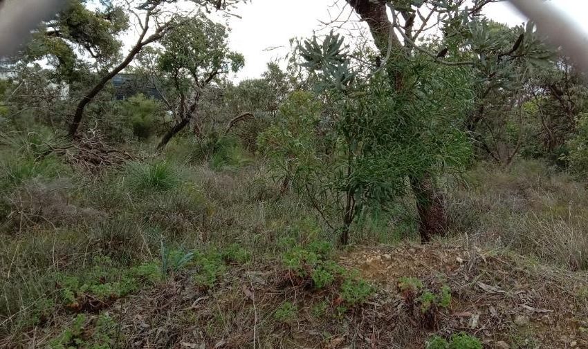
4782AA_Rev1                                                    Desktop Environmental Assessment Report
                                                                         Lot 175, Kenhelm Street, Balcatta
                                                                                              Charter Hall

1              Introduction
1.1            Background
360 Environmental Pty Ltd (360 Environmental) has been commissioned by Charter Hall to
conduct an environmental assessment and site visit for Lot 175, 20 Kenhelm Street Balcatta (the
site) (Figure 1).

The site is 2.006 ha and located approximately 13 km north of Perth CBD. The site is zoned
‘industrial’ by the Metropolitan Region Scheme (MRS), and it is zoned ‘industrial’ by the City of
Stirling Local Planning Scheme No. 2 (LPS).
The purpose of this Environmental Assessment Report (EAR) is to support the development
application and approvals process relating to the future development of the site.

1.2            Environmental Assessment Objectives
The objective of the environmental assessment is to provide an understanding of the
environmental aspects associated with the development of the site including opportunities,
constraints, and management.

1.3            Scope of Works
The scope of works for EAR included:

      •   NatureMap database search.

      •   Searches of the Federal Department of Agriculture, Water and Environment’s (DAWEs)
          Environment Protection and Biodiversity Conservation Act 1999 Protected Matters
          Search Tool.
      •   Review of publicly listed ecological information where available (previous reports and
          any relevant scientific literature).
      •   Review of applicable environmental legislation, policies and guidelines and their
          relevance to the site.
      •   Topography, soil, and potential acid sulfate soils.
      •   Groundwater levels, groundwater protection areas, surface water and geomorphic
          wetlands.
      •   Review of regional vegetation association and complex mapping (Beard and Heddle).
      •   Fauna and Black Cockatoo desktop habitat assessment, DBCA NatureMap and DAWE
          MNES PMST databases for recorded species within the vicinity of the site
      •   Undertake a black cockatoo habitat assessment to identify individual (potential and
          actual) black cockatoo breeding trees.
      •   Identify evidence (if any) of black cockatoo foraging and assess the quality of foraging
          habitat within the site.

 360 Environmental Pty Ltd                                                                                   4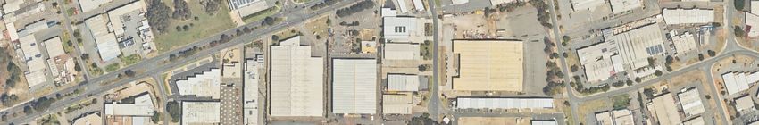
4782AA_Rev1                                               Desktop Environmental Assessment Report
                                                                   Lot 175, Kenhelm Street, Balcatta
                                                                                        Charter Hall

   •   Identify and map areas of black cockatoo foraging and roosting habitat and assess the
       quality of this habitat.
   •   Site visit to conduct a flora and vegetation assessment.
   •   Heritage sites (Aboriginal and non-Aboriginal) that may be located within or nearby the
       site. Search of the Department of Planning Lands and Heritage (DPLH) Aboriginal and
       State and Local Heritage databases.
   •   Identification of environmental constraints and opportunities associated with the site.

360 Environmental Pty Ltd                                                                              5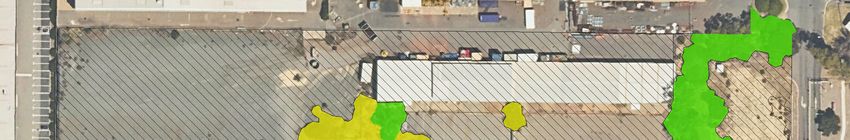
4782AA_Rev1                                                  Desktop Environmental Assessment Report
                                                                       Lot 175, Kenhelm Street, Balcatta
                                                                                            Charter Hall

2              Legislation
2.1            Commonwealth Legislation

2.1.1          Environmental Protection and Biodiversity Act 1990
The Environment Protection and Biodiversity Conservation Act 1999 (EPBC Act) is the central
piece of environmental legislation which protects Matters of National Environmental
Significance (MNES). Environmental Assessments under the EPBC Act are undertaken to enable
environment and heritage protection and biodiversity conservation. An action should not be
undertaken that has, will have or is likely to have a significant impact on any MNES, or other
protected matters without a pre-action referral to the Australian Government’s Minister for the
Environment.

2.1.2          Native Title Act 1993
The Native Title Act 1993 (NTA) recognises the traditional rights and interests to land and water
of Aboriginal and Torres Strait Islander People. Under the NTA, a native title claimant can make
an application to the Federal Court to have their claim recognised by Australian Legislation.

2.2            State Legislation
The Environmental Protection Act 1986 (EP Act) is the key legislative tool for environmental
protection in Western Australia. It is administered by the Department of Water and
Environmental Regulation (DWER) and the Minister for Environment.
Table 1 provides a summary of the key State legislation and regulations relevant to the site.
Table 1: Key State Legislation

         Key Legislation               Responsible Government                     Aspect
                                               Agency

                                   Department of Planning, Lands     Archaeological and
 Aboriginal Heritage Act 1972
                                   and Heritage                      ethnographic heritage

 Aboriginal Heritage Regulations   Department of Planning, Lands     Archaeological and
 1974                              and Heritage                      ethnographic heritage

                                   Department of Primary
 Agricultural and Related
                                   Industries and Regional           Weeds and feral animals
 Resources Protection Act 1976
                                   Development

 Biodiversity Conservation Act     Department of Biodiversity        Listing of and protection of
 2016                              Conservation and Attractions      native species, threatened
                                                                     species, ecological
                                                                     communities, fauna, critical
                                                                     habitat, and threatening
                                                                     processes

 360 Environmental Pty Ltd                                                                                 6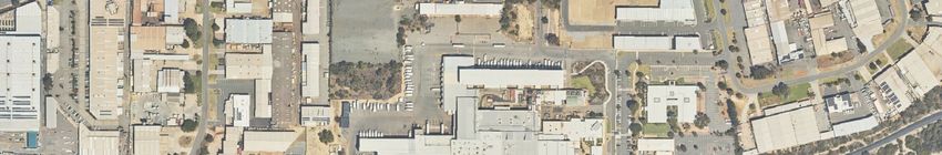
4782AA_Rev1                                                  Desktop Environmental Assessment Report
                                                                       Lot 175, Kenhelm Street, Balcatta
                                                                                            Charter Hall

         Key Legislation              Responsible Government                      Aspect
                                              Agency

                                   Department of Primary
 Biosecurity and Agriculture
                                   Industries and Regional           Weeds / pests / diseases
 Management Act 2007
                                   Development

 Bush Fires Act 1954               Department of Fires and           Bush fire control
                                   Emergency Services

 Conservation and Land             Department of Biodiversity        Flora and fauna / habitat /
 Management Act 1984               Conservation and Attractions      weeds / pests / diseases
                                   Department of Agriculture

 Conservation and Land             Department of Biodiversity        Flora and fauna / habitat /
 Management Regulations 2002       Conservation and Attractions      weeds / pests / diseases
                                   Department of Agriculture

 Contaminated Sites Act 2003       Department of Water and           Management of contaminated
                                   Environmental Regulation          soils and water

 Environmental Protection Act      Environmental Protection          Part IV – Environmental Impact
 1986                              Authority                         Assessment
                                   Department of Water and           Part V – Works Approvals and
                                   Environmental Regulation          Licences, Clearing Permits

 Environmental Protection          Department of Water and           Clearing of native vegetation
 (Clearing of Native Vegetation)   Environmental Regulation
 Regulations 2004

 Planning and Development Act      Department of Planning, Lands     Structure planning and
 2005                              and Heritage                      subdivision approval

 Rights in Water and Irrigation    Department of Water and           Governs management of the
 Act 1914                          Environmental Regulation          use, service and health of water
                                                                     and watercourses (including
                                                                     beds and banks).
                                                                     Water licensing is required in all
                                                                     proclaimed areas and for all
                                                                     artesian groundwater wells
                                                                     throughout the state.

2.3            Relevant Standard, Guidelines and Policies
Clearing and development is subject to compliance with applicable standards, guidelines and
policies developed by the State’s regulators to assist proponents in understanding the minimum
requirements for environmental protection. Table 2 details the key standards, guidelines, and
policies relevant to future industrial development of the site.

 360 Environmental Pty Ltd                                                                                 7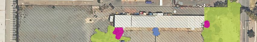
4782AA_Rev1                                                   Desktop Environmental Assessment Report
                                                                        Lot 175, Kenhelm Street, Balcatta
                                                                                             Charter Hall

Table 2: Relevant Policies and Guidelines

                 Document                                        Description
 EPA Policies and Guidance
 Statement of Environmental            This statement communicates the EPA considers the object
 Principles, Factors and Objectives    and principles of the EP Act, uses environmental factors and
 (EPA 2016a)                           objectives to organise and systemise environmental impact
                                       assessment, taking a holistic view of the environment and
                                       considering significance of a proposal.
 Environmental Factor Guideline –      Provides guidance to protect flora and vegetation so that
 Flora and Vegetation (EPA 2016b)      biological diversity and ecological integrity are maintained.
 Environmental Factor Guideline –      Provides guidance with the objective to maintain the quality
 Terrestrial Environmental Quality     of land and soils so that environmental values are protected.
 (EPA 2016c)
 Environmental Factor Guideline –      Provides guidance with the objective to protect terrestrial
 Terrestrial Fauna (EPA 2016d)         fauna so that biological diversity and ecological integrity at
                                       maintained.
 Technical Guidance – Flora and        Provides technical guidance to ensure adequate flora and
 Vegetation Surveys for                vegetation data of an appropriate standard are obtained and
 Environmental Impact Assessment       used in environmental impact assessment.
 (EPA 2016e)
 Technical Guidance – Terrestrial      Provides technical on the direction and information on
 Fauna Surveys (EPA 2016)              general standards and protocols for terrestrial fauna surveys
                                       for environmental impact assessment.
 Guidance Statement No. 3:             Provides guidance on the generic separation (buffer)
 Separation Distances between          distances between Industrial and Sensitive land uses to avoid
 Industrial and Sensitive Land Uses    conflicts between these land uses.
 (EPA 2005)
 Guidance Statement No. 33:            Provides information and advice to assist land use planning
 Environmental Guidance for Planning   and development processes to protect, conserve and
 and Development (EPA 2008)            enhance the environment.
 WA Environmental Offsets Policy       Seeks to protect and conserve environmental and
 (EPA 2011)                            biodiversity values for present and future generations. The
                                       policy ensures that economic and social development may
                                       occur while supporting long term environmental and
                                       conservation values.
 EPA Bulletins
 Environmental Protection Bulletin     Clarifies how the EPA will consider offsets through the
 No. 1: Environmental Offsets (EPA     environmental impact assessment process.
 2014b)
 Department of Water and Environmental Regulation (DWER) Guidelines
 Assessment and management of          Provides guidance on the assessment and management of
 contaminated sites Guideline (DER     contaminated sites in Western Australian within legislative
 2014)                                 framework of the Contaminated Sites Act 2003 and the
                                       Contaminated Sites Regulations 2006.

 360 Environmental Pty Ltd                                                                                  8
4782AA_Rev1 Desktop Environmental Assessment Report
Lot 175, Kenhelm Street, Balcatta
Charter Hall
Document Description
Identification and investigation of
Provides guidance to assist with the identification,
acid sulfate soils and acidic
assessment, and management of acid sulfate soils in Western
landscapes (Department of
Australia.
Environment Regulation, 2015)
Water Quality Protection Note No. This note provides guidance for land use planning within
25 Land Use Compatibility Tables for onshore PDWSAs. It sets out guidelines on appropriate land
public drinking water uses and activities within PDWSAs that represents best
source areas (Department of Water, management practice to protect water quality and public
2016) health.
360 Environmental Pty Ltd 94782AA_Rev1 Desktop Environmental Assessment Report
Lot 175, Kenhelm Street, Balcatta
Charter Hall
3 Site Environmental Features
3.1 Climate
The nearest long-term Bureau of Meteorology (BoM) weather station with a complete dataset
is the Perth Metro Station (Station 009225). The weather station is located approximately 6.6
km south of the site.
Perth Metro station has been opened since 1993 to date. The long-term mean minimum
temperature for the station is 12.8° and the mean maximum is 24.8 °. The station receives
rainfall 108.1 days annually with a mean rain of 730.9 mm per year.
Rainfall
Max. temperature
35 Min. temperature 160
30 140
120
25
Temperature (°C)
Rainfall (mm)
100
20
80
15
60
10
40
5 20
0 0
Graph 1: Long-term monthly rainfall, mean maximum and mean minimum temperature for
Perth Metro (Station No. 009225)
3.2 Surrounding Land Uses
The site is zoned ‘industrial’ under the State’s Metropolitan Region Scheme (MRS), and it is
zoned ‘industrial’ under the City of Stirling Local Planning Scheme (LPS) No.3 (Department of
Planning Lands and Heritage, 2021). The site is surrounded by industrial properties.
3.3 Topography
The elevation across the site ranges between 21 m Australian Datum Height (ADH) and 24
m ADH (Landgate, 2021).
360 Environmental Pty Ltd 104782AA_Rev1 Desktop Environmental Assessment Report
Lot 175, Kenhelm Street, Balcatta
Charter Hall
3.3.1 Soil Landscapes and Land Systems
Soil landscapes and land system mapping of Western Australia describes broad soil and
landscape characteristics from regional to local scales, and has been captured at scales ranging
from 1:20,000 to 1:250,000 (Department of Agriculture and Food WA, 2012). The site occurs
within one land system:
• Spearwood system: characterized by sand dunes and plains. The soils are described as
yellow deep sands, pale deep sands, and yellow/brown shallow sands.
Soil landscape subsystem within the site is described below:
• EnvGeol S7 Phase -211Sp__S7: the subsystem has sand - pale and olive yellow in colour.
The texture is medium to coarse-grained. Soil particles are sub-angular to sub-rounded
quartz with traces of feldspar and are moderately sorted of residual origin.
3.3.2 Acid Sulfate Soils
Acid Sulfate Soil (ASS) mapping undertaken by the Department of Water and Environmental
Regulation (DWER) indicates that the site has no known ASS disturbance risk (DWER, 2021a).
The nearest mapped ASS risk area is located 1.6 km southwest of the site.
3.4 Hydrology
Groundwater and surface water in Western Australia is protected under the Rights in Water and
Irrigation Act 1914 (RIWI Act). The site is situated within a RIWI ground water proclaimed area
and under the Swan River System surface water proclamation areas (DWER, 2017).
3.4.1 Groundwater
The surface geology of the site consists of the Tamala limestone which have aeolian calcarenite,
variably lithified and leached quartz sand. Groundwater salinity levels are 250 mg/L (DWER,
2021e). The depth of the water table from the ground level is 9m and the base of the
underground aquifer is 38 m.
The site is located with the Gwelup Underground Water Pollution Control Area, Public Drinking
Water Source Areas (PDWSA) (DWER,2021b).
3.4.2 Surface Water
A review of the GIS hydrology dataset shows that the site does not intercepts any surface
watercourses, rivers, creeks, or streams (DWER,2021c).
3.4.3 Wetlands
Wetlands of the Swan Coastal Plain have been described and mapped by Hill et al. (1996) and
assigned a management category which reflects their condition and environmental value. There
are three categories that wetlands are assigned, ‘Conservation Category’ (CCW), ‘Resource
Enhancement’ (REW) and ‘Multiple Use’ (MUW) depending on their condition and
360 Environmental Pty Ltd 114782AA_Rev1 Desktop Environmental Assessment Report
Lot 175, Kenhelm Street, Balcatta
Charter Hall
environmental values. CCWs are those with the highest level of ecological attributes and
functions, followed by REWs then MUWs.
An interrogation of the DBCA geomorphic wetlands mapping did not identify any wetlands
within the site. No Ramsar site was identified within the site or 10 km in the vicinity.
3.5 Environmentally Sensitive Areas
Environmentally Sensitive Areas (ESAs) are declared by the Department of Water and
Environmental Regulation (DWER) under the Environmental Protection (Environmentally
Sensitive Areas) Notice 2005 to prevent the degradation of important environmental values such
as Threatened flora, Threatened Ecological Communities (TECs) or significant wetlands. Under
the Notice it is an offence to kill or destroy vegetation within an ESA.
The site is not mapped within an ESA. The nearest ESA to the site is located approximately 1.8
km north of the site (DWER, 2021d).
3.6 Flora and Vegetation
3.6.1 Desktop
3.6.1.1 Bioregion
The site is located within the Swan Coastal Plain bioregion of the Interim Biogeographic
Regionalisation of Australia (IBRA). The Swan Coastal Plain Perth subregion (SWA02) is a low-
lying coastal plain composed of colluvial and aeolian sands, alluvial river flats and coastal
limestone rising to duricrust Mesozoic sediments in the east. Outwash plains are extensive only
in the south, while a complex series of seasonal wetlands and swamps extends from north to
south. Vegetation comprises heath and/or Tuart woodlands on limestone, Banksia, and Jarrah-
Banksia woodlands on quaternary marine dunes of various ages, Marri on colluvial and alluvial
soils, Casuarina obesa on out-wash plains, and paperbark (Melaleuca spp.) in wetland areas
(Mitchell et al. 2002).
3.6.1.2 Broad Vegetation Types
Vegetation mapping of the Swan Coastal Plain of WA was completed on a broad scale
(1:250,000) by Beard (1972-80). These vegetation units were re-assessed by Shepherd et al.
(2001) to account for clearing in the intensive land use zone, dividing some larger vegetation
units into smaller units. One vegetation unit is present within the site is described below:
• Spearwood 6: the floristic descriptions are characterised by the Jarrah, marri, and
wandoo. The Eucalyptus marginata, Corymbia calophylla and E. wandoo are also a part
of the vegetation.
Table 3 provides the Spearwood vegetation current representation compared to state and
regional levels.
360 Environmental Pty Ltd 124782AA_Rev1 Desktop Environmental Assessment Report
Lot 175, Kenhelm Street, Balcatta
Charter Hall
Table 3: Broad Vegetation Types within the State, Regional and Local Representation.
Current Extent
Pre-European Current Extent
Vegetation Type Remaining (%) Managed in DBCA
Extent (ha) (ha)
Lands (%)
Representation across Western Australia
Spearwood 6 56,343.01 13,362.25 23.72 39.83
Representation across the Swan Coastal Plain Bioregion
Spearwood 6 56,343.01 13,362.25 23.72 39.83
Representation across the Perth subregion
Spearwood 6 56,343.01 13,362.25 23.72 39.83
Representation across the City of Stirling
Spearwood 6 5,380.68 208.78 3.88 -
The EPA aims to retain ecological communities at a minimum of 30% of the pre-clearing extent
of that community in each bioregion to meet the National Objectives and Targets for Biodiversity
Conservation 2001-2005 (Commonwealth of Australia 2001) (EPA 2008). The Spearwood_6
vegetation type does not meet the recommendation; it has 23.72% representation remaining
within the State.
Vegetation complexes of the Swan Coastal Plain have been mapped by Heddle et al. (1980). The
site contains one vegetation complex:
• Karrakatta Complex-Centraland\South: Predominantly open forest of E. gomphocephala
(Tuart), E. marginata (Jarrah), Corymbia calophylla (Marri) and woodlands of E.
marginata (Jarrah) and Banksia species. Agonis flexuosa (Peppermint) is co-dominant
south of the Capel River.
Table 4: Vegetation Complex representation within the IBRA Region, Perth Metropolitan
Region and Local Government Authority.
Current Extent
Pre-European Current Extent
Vegetation Complex Remaining (%) Managed in DBCA
Extent (ha) (ha)
Lands (%)
IBRA Region Swan Coastal Plain
Karrakatta Complex-
53,080.99 12,467.20 23.49 3.87
Centraland\South
Perth Metropolitan Region
Karrakatta Complex-
34,596.71 4,291.55 12.40 1.39
Centraland\South
Local Government Authority, City of Stirling
Karrakatta Complex-
5,458.42 210.28 3.85 -
Centraland\South
EPA Policy recommends that on the SCP vegetation complexes are maintained above the
threshold level of 30% of the original pre-clearing extent of each community and 10% of the
360 Environmental Pty Ltd 134782AA_Rev1 Desktop Environmental Assessment Report
Lot 175, Kenhelm Street, Balcatta
Charter Hall
original pre-clearing extent of each community representation within the Perth Metropolitan
Region. The Karrakatta Complex-Central and\South complex is below the 30% threshold within
the region but above the recommended 10% in the Perth Metropolitan.
3.6.1.3 Flora Database Searches
A desktop review of the NatureMap (Appendix A) PMST (Appendix B) and DBCA database
searches were conducted to identify flora species that could potentially occur within the site.
The review identified 12 significant flora species that may occur within a 5 km radius of the site,
as listed in Table 5.
Table 5: Significant Flora that may occur within the site.
Scientific Name Common Name Conservation Status
DBCA EPBC
Amanita preissii Cinnamon-ring Lepidella P3
Andersonia gracilis Slender Andersonia T EN
Anigozanthos viridis subsp.
Dwarf Green Kangaroo Paw T VU
terraspectans
Diuris micrantha Dwarf Bee-orchid T VU
Diuris purdiei Purdie's Donkey-orchid T EN
Glossy-leafed Hammer Orchid, Glossy-
Drakaea elastica T EN
leaved Hammer Orchid
Drakaea micrantha Dwarf Hammer-orchi T VU
Eleocharis keigheryi Keighery's Eleocharis T VU
Eucalyptus argutifolia Yanchep Mallee, Wabling Hill Mallee T VU
Jacksonia sericea Waldjumi P4
Synaphea sp. Fairbridge
Selena's Synaphea T CR
Farm (D. Papenfus 696)
Thelymitra stellata Star Sun-orchid T EN
3.6.1.4 Threatened and Priority Ecological Communities Database Searches
A desktop review of the PMST database identified two (2) Threatened Ecological Communities
(TEC) that may potentially occur within a 5 km radius of the site (Appendix B). The following
communities were identified:
• Banksia Woodlands of the Swan Coastal Plain ecological community (EN)
• Tuart (Eucalyptus gomphocephala) Woodlands and Forests of the Swan Coastal Plain
ecological community (CR).
360 Environmental Pty Ltd 144782AA_Rev1 Desktop Environmental Assessment Report
Lot 175, Kenhelm Street, Balcatta
Charter Hall
3.6.2 Flora and Vegetation Site Assessment
3.6.2.1 Method
The site assessment was undertaken by Principal Botanist Narelle Whittington (FB62000177 and
TFL70 - 1920) on 21 July 2021. The site was traversed on foot and included an assessment using
mapping notes, photographs, and observations. The vegetation remnant on the northwest side
of the site is entirely fenced with 1.8 meter (m) high chain mesh fencing with barb wire,
consequently, was unable to be accessed. The survey was, therefore, undertaken from the fence
line.
A handheld Garmin GPS unit was used to record information and several photographs were
taken.
3.6.3 Results
3.6.3.1 Flora
The survey recorded a total of 31 taxa from 29 genera across 18 families. The most dominant
families were Fabaceae (seven species) and Myrtaceae, Poaceae and Proteaceae (with three
species each). A full species inventory is detailed in Appendix C. Of the 31 taxa, 11 were
introduced species.
3.6.3.2 Introduced Flora
While introduced species were not extensively searched for during the site visit, a total of 11
introduced species were recorded, representing 35.5% of the total taxa recorded (Table 6). The
11 species were checked for their significance under the Biosecurity and Agriculture
Management Act 2007 (BAM Act) (Department of Primary Industries and Regional
Development, 2018a) and the Weeds of National Significance (WoNS) listing (Table 3).
Table 6: Introduced Flora Species within the site
Species Common Name Status under BAM Act WoNS
*Acacia iteaphylla Flinders Range wattle Permitted - s11 No
*Ehrharta calycina Perennial Veldt Grass Permitted - s11 No
*Eragrostis curvula African Love Grass Permitted - s11 No
Geraldton Carnation
*Euphorbia terracina Permitted - s11 No
Weed
*Foeniculum vulgare fennel Permitted - s11 No
*Linaria maroccana Moroccan toadflax Permitted - s11 No
*Lupinus cosentinii Blue Lupin Permitted - s11 No
*Melinis repens Natal redtop Permitted - s11 No
*Oxalis pes-caprae Soursob Permitted - s11 No
*Pelargonium capitatum Rose Pelargonium Permitted - s11 No
360 Environmental Pty Ltd 154782AA_Rev1 Desktop Environmental Assessment Report
Lot 175, Kenhelm Street, Balcatta
Charter Hall
Species Common Name Status under BAM Act WoNS
*Ricinus communis Castor oil plant Permitted - s11 No
3.6.3.3 Vegetation Types
A total of four vegetation types were mapped within the site and covered 0.66 ha (32.8% of site)
(Figure 2). Within the 2.01 ha site, 1.35 ha was cleared. The vegetation within the site ranged
from intact woodlands in Excellent condition to Completely Degraded scattered mature trees
over introduced weed and garden variety species. Descriptions of these are listed in Table 7
along with their extent within the site.
Table 7: Vegetation Types Occurring within the site
Vegetation Extent (ha) in the
Vegetation Type Description
Type Code site
Mid Woodland of Eucalyptus marginata, Banksia attenuata,
EmBa Banksia menziesii over low shrubland of Xanthorrhoea preissii,
0.36
Hibbertia hypericoides, and Macrozamia riedlei over mid
sedgeland of Mesomelaena pseudostygia.
Mature Eucalyptus marginata that is not in association with any
Em 0.01
other native species
NeE Isolated mature Non-endemic Eucalypt 0.01
Weeds and
Areas of Introduced species and Garden variety plants 0.28
Garden
Plate 1: Vegetation Type EmBa
360 Environmental Pty Ltd 164782AA_Rev1 Desktop Environmental Assessment Report
Lot 175, Kenhelm Street, Balcatta
Charter Hall
3.6.3.4 Threatened Ecological Communities
Vegetation type EmBa has been determined to have affiliation with Banksia woodlands of the
Swan Coastal Plain ecological community, which, is listed as Endangered under the EPBC Act and
as a Priority 3 by the State.
3.6.3.5 Condition
The majority of the site is hardstand with various buildings, infrastructure, and associated items.
The vegetation in the site equates to 0.66 ha and ranged from Excellent to Completely Degraded
(Environmental Protection Authority, 2016) (Figure 3) (Table 8). The vegetation remnant
identified as EmBa is considered to be in predominantly Excellent condition with the north-west
corner being in good condition. The remaining pockets of vegetation in the site have been
mapped as completely Degraded given that they consist of introduced and garden variety
species.
Table 8: Vegetation Condition within the site
Extent within the Extent within the
Vegetation Condition
site (ha) site (%)
Excellent 0.29 14.42
Good 0.07 3.48
Completely Degraded 0.30 14.92
Cleared 1.35 67.16
Total 2.01 100
3.7 Fauna
3.7.1 Desktop
An assessment of the NatureMap (Appendix A), PMST (Appendix B) and DBCA databases
identified 37 conservation significant fauna species that may occur within a 5 km radius of the
site (Table 9). The likelihood of these conservation significant fauna species occurring within the
site has been assessed based on current distributions, habitat preferences and proximity of
NatureMap records.
Table 9: Significant Fauna that may occur within the site.
Conservation Status
Scientific Name Common Name Likelihood of Occurrence
DBCA EPBC
Birds
Negligible (no suitable
Actitis hypoleucos Common Sandpiper MI MI, MA
habitat)
Negligible (no suitable
Botaurus poiciloptilus Australasian Bittern EN EN
habitat)
Sharp-tailed Negligible (no suitable
Calidris acuminata MI MI, MA
sandpiper habitat)
360 Environmental Pty Ltd 174782AA_Rev1 Desktop Environmental Assessment Report
Lot 175, Kenhelm Street, Balcatta
Charter Hall
Conservation Status
Scientific Name Common Name Likelihood of Occurrence
DBCA EPBC
EN, MI, Negligible (no suitable
Calidris canutus Red Knot, Knot EN
MA habitat)
EN, MI, Negligible (no suitable
Calidris ferruginea Curlew Sandpiper CR
MA habitat)
Negligible (no suitable
Calidris subminuta Long-toed Stint MI
habitat)
Calyptorhynchus Red-tailed black High (nearby records,
VU VU
banksii naso cockatoo suitable habitat present)
Calyptorhynchus Carnaby’s black High (nearby records,
EN EN
latirostris cockatoo suitable habitat present)
White-winged Negligible (no suitable
Chlidonias leucopterus MI
Black Tern habitat)
Negligible (no suitable
Falco peregrinus Peregrine Falcon OS
habitat)
Negligible (no suitable
Hydroprogne caspia Caspian Tern MI MI, MA
habitat)
Australian Little
Negligible (no suitable
Ixobrychus dubius Bittern (Black- P4
habitat)
backed Bittern)
Negligible (outside current
Leipoa ocellata Malleefowl VU VU
known distribution)
Limosa lapponica Northern Siberian Negligible (no suitable
CR CR
menzbieri Bar-tailed Godwit habitat)
Negligible (no suitable
Limosa limosa Black-tailed Godwit MI MI, MA
habitat)
Numenius Eastern Curlew, Far CR, MI, Negligible (no suitable
CR
madagascariensis Eastern Curlew MA habitat)
Negligible (no suitable
Oxyura australis Blue-billed Duck P4
habitat)
Negligible (no suitable
Plegadis falcinellus Glossy Ibis MI
habitat)
Australian Painted Negligible (no suitable
Rostratula australis EN EN, MA
Snipe habitat)
Australian Fairy Negligible (no suitable
Sternula nereis nereis VU VU
Tern habitat)
Thalassarche Grey-headed EN, MI, Negligible (no suitable
VU
chrysostoma Albatross MA habitat)
Crested Tern
Negligible (no suitable
Thalasseus bergii (Greater Crested MI MI, MA
habitat)
Tern)
Negligible (no suitable
Tringa glareola Wood Sandpiper MI MI, MA
habitat)
360 Environmental Pty Ltd 184782AA_Rev1 Desktop Environmental Assessment Report
Lot 175, Kenhelm Street, Balcatta
Charter Hall
Conservation Status
Scientific Name Common Name Likelihood of Occurrence
DBCA EPBC
Common Negligible (no suitable
Tringa nebularia MI MI, MA
Greenshank habitat)
Negligible (no suitable
Tringa stagnatilis Marsh Sandpiper MI MI, MA
habitat)
Arachnids
Swan Coastal Plain Low (no recent nearby
Idiosoma sigillatum Shield-backed P3 records, cannot be ruled out
Trapdoor Spider as species is poorly surveyed)
Insects
Low (no nearby records,
Australotomurus
Guildford springtail P3 cannot be ruled out as
morbidus species is poorly known)
Douglas' Broad- Low (no nearby records,
Hesperocolletes
headed Bee, CR CR cannot be ruled out as
douglasi species is poorly known)
Rottnest Bee
High (nearby records,
Synemon gratiosa Graceful Sun Moth P4
suitable habitat present)
Reptiles
Negligible (no suitable
Neelaps calonotos Black-striped Snake P3
habitat)
Mammals
Bettongia penicillata Negligible (outside current
Woylie CR EN
ogilbyi known distribution)
Dasyurus geoffroii Chuditch, Western Negligible (outside current
VU VU
fortis Quoll known distribution)
Hydromys Negligible (no suitable
Water Rat P4
chrysogaster habitat)
Negligible (no suitable
Isoodon fusciventer Quenda P4
habitat)
Western Brush Negligible (no suitable
Notamacropus irma P4
Wallaby habitat)
Phascogale tapoatafa Wambenger Brush- Negligible (no suitable
OS
wambenger tailed Phascogale habitat)
Pseudocheirus Western Ringtail Negligible (outside current
CR CR
occidentalis Possum, Ngwayir, known distribution)
3.8 Black Cockatoo Habitat Assessment
3.8.1 Desktop
The site occurs within the known breeding distribution of the Carnaby’s Black Cockatoo
(Department of Sustainability Environment Water Population and Communities, 2012;
Department of the Environment and Energy, 2017). NatureMap shows 7,437 records of the
360 Environmental Pty Ltd 194782AA_Rev1 Desktop Environmental Assessment Report
Lot 175, Kenhelm Street, Balcatta
Charter Hall
species within a 20 km radius of the site, of which eight occurred within 1 km and 2,880 occurred
within the last ten years (Department of Biodiversity Conservation and Attractions, 2021a).
NatureMap records suggest that Carnaby’s Black Cockatoos forage and roost within 5 km of the
site (Department of Biodiversity Conservation and Attractions, 2021a).
The site occurs within the known breeding distribution of the Forest Red-tailed Black Cockatoo
(Department of Sustainability Environment Water Population and Communities, 2012;
Department of the Environment and Energy, 2017). NatureMap shows 108 records of the
species within a 20 km radius of the site, of which three occurred within 1 km and 101 occurred
within the last ten years (Department of Biodiversity Conservation and Attractions, 2021a).
NatureMap records suggest that Forest Red-tailed Black Cockatoo forage within 5 km of the site.
The closest NatureMap record is less than 100m away and records four Forest Red-tailed Black
Cockatoo foraging on Marri trees in 2017 (Department of Biodiversity Conservation and
Attractions, 2021a).
The site occurs outside the known breeding distribution of the Baudin’s Black Cockatoo
(Department of Sustainability Environment Water Population and Communities, 2012;
Department of the Environment and Energy, 2017). NatureMap shows 22 records of the species
within a 20 km radius of the site, of which none occurred within 1km and nine occurred within
the last ten years (Department of Biodiversity Conservation and Attractions, 2021a).
3.8.2 Methods
The black cockatoo survey was undertaken by senior zoologist Evan Webb and ecologists
Christina Walker and Lachlan Crossley on 28 July 2021. The site was traversed, and breeding,
foraging and roosting habitat was identified and recorded. Any tree hollows observed within
the site were inspected using a DJI Mini 2 drone. The survey was conducted in accordance with
the Environment Protection and Biodiversity Conservation Act 1999 (EPBC Act) Referral
Guidelines for Three Threatened Black Cockatoo Species (Department of Sustainability
Environment Water Population and Communities, 2012) and with due regard for the revised
draft referral guideline for Three Threatened Black Cockatoo Species (Department of the
Environment and Energy, 2017). Foraging habitat quality was assessed using criteria based on
the Foraging Habitat Scoring Tool (Department of the Environment and Energy, 2017).
3.8.3 Results
3.8.3.1 Breeding Habitat
A total of four Jarrah (Eucalyptus marginata) trees were recorded as potential breeding trees
i.e. with a diameter at breast height (DBH) of greater than 500 mm. One tree contained two
hollows, of which one was obviously too small for black cockatoo use (Plate 2) and one had an
entrance diameter of approximately 100 mm (Plate 3). This is considered the minimum entrance
diameter for hollows to be suitable for use by black cockatoos (Groom, 2010), however, the
hollow was assessed as unsuitable black cockatoo use as it did not appear to widen internally.
Black cockatoos are large birds, ranging from 95 to 130 mm at their widest point (Saunders,
360 Environmental Pty Ltd 204782AA_Rev1 Desktop Environmental Assessment Report
Lot 175, Kenhelm Street, Balcatta
Charter Hall
Smith and Rowley, 1982; Groom, 2010), therefore the hollow would be too restrictive. Saunders,
Smith and Rowley (1982) found that internal diameters were, on average, larger than entrance
diameters. There were possible chew marks around the hollow entrance indicating that the
hollow had been previously used, most likely by a smaller psittacine such as a Galah or Australian
Ringneck (Plate 3).
The locations of the trees are shown on Figure 3 and raw data is displayed in Appendix D.
Plate 2: Tree hollow (unsuitable for black cockatoo use, too small)
360 Environmental Pty Ltd 214782AA_Rev1 Desktop Environmental Assessment Report
Lot 175, Kenhelm Street, Balcatta
Charter Hall
Plate 3: Tree hollow (unsuitable for black cockatoo use, internal diameter appears too
small)
3.8.3.2 Foraging Habitat
A total of 0.29 hectares of very high-quality foraging habitat was recorded within the site,
containing known black cockatoo foraging species such as Jarrah and Banksia spp. A total of 0.11
hectares of quality foraging habitat was recorded within the site, containing a mix of native
species such as Jarrah and non-endemic foraging species such as planted Grevillea sp.,
Callistemon sp., and Olea sp.. A total of 0.15 hectares of low quality foraging habitat was
recorded within the site, containing non-endemic foraging species listed above.
No evidence of black cockatoo foraging was observed. Foraging habitat is mapped in Figure 3
and the results of the Foraging Habitat Scoring Tool are displayed in full in Appendix E.
3.8.3.3 Roosting Habitat
A total 0.34 hectares of roosting habitat was recorded within the site, comprising habitat
containing Jarrah trees (Eucalyptus marginata). No evidence of black cockatoo roosting was
observed.
3.8.3.4 Black Cockatoo Observations
There were no direct sightings or calls recorded during the field survey.
360 Environmental Pty Ltd 224782AA_Rev1 Desktop Environmental Assessment Report
Lot 175, Kenhelm Street, Balcatta
Charter Hall
3.9 Reserves and Conservation Areas
The site does not intersect any reserves or conservation areas. No Bush forever sites are found
within a 10 km boundary of the site.
3.10 Ecological Linkages
The retention of native vegetation and fauna habitat within Ecological Linkages aims to reduce
the loss of biodiversity and key ecological functions across the Swan Coastal Plain. Mapping of
Regional Ecological Linkages of the Swan Coastal Plain identifies that the site is not intercepted
by any ecological linkage axis lines. The nearest ecological linkage is approximately 180 m
northwest of the site.
3.11 Heritage
3.11.1 Aboriginal Heritage
In Western Australia, the Aboriginal Heritage Act 1972 protects places and objects customarily
used by or traditional to the original habitants of Australia. A register of such places and objects
in maintained under the Act, however all sites are protected under the Act whether they are
registered or not.
A search of the Department of Planning, Lands and Heritage’s (DPLH) Aboriginal Heritage Inquiry
System (AHIS) did not identify any Aboriginal Heritage sites within the site (DPLH,2021)
3.11.2 European Heritage
A review of the State Heritage Office (SHO) state register dataset did not find registered state,
world or national heritage places were within the Study Area (State Heritage Office,2021).
3.11.3 Contaminated Sites
Under the Contaminated Sites Act 2003, Contaminated Sites must be reported to DER,
investigated and, if necessary, remediated. There are no registered Contaminated Sites within
the site. The nearest registered site is parcel ID: 76848, Remediated for Restricted Use site which
is approximately 200 m southeast of the site (DWER, 2021d).
360 Environmental Pty Ltd 234782AA_Rev1 Desktop Environmental Assessment Report
Lot 175, Kenhelm Street, Balcatta
Charter Hall
4 Summary Environmental Constraints and Management
The site was assessed for environmental issues that may have impact on the development of
the site for further industrial use. The following section outlines a summary of the issue and
management.
Flora and Vegetation
Vegetation type EmBa has been determined to have affiliation with Banksia woodlands of the
Swan Coastal Plain ecological community, which, is listed as Endangered under the EPBC Act and
as a Priority 3 by the State. For vegetation to be considered as the Endangered TEC under the
EPBC Act and warrant full national protection, the community has to meet key diagnostic
characteristics. Regarding the presence of the TEC, the approved conservation advice for the
thresholds state that for vegetation in Excellent condition, the minimum patch size should be
0.5 ha. Considering the Banksia woodland vegetation type on site is 0.36 ha it does not meet the
Commonwealth criteria for protection.
Fauna
The site occurs within the breeding distributions of Carnaby’s Black Cockatoos and Forest Red-
tailed Black Cockatoos. A total of four potential breeding trees were recorded. One tree
contained two hollows but both were assessed as unsuitable for black cockatoo use. A total of
0.55 hectares of foraging habitat, comprising Jarrah, Banksia sp. and non-endemic foraging
plants, and 0.34 hectares of roosting habitat, comprising Jarrah, was recorded within the site.
No evidence of black cockatoos using the site was observed.
Black cockatoos (and their habitat) are considered Matters of National Environmental
Significance (MNES). Any impacts to MNES should consider referral to DAWE under the EPBC
Act.
Acid Sulfate Soils
The nearest mapped ASS risk area is located 1.6 km Southwest of the site. However, Department
of Environment Regulation (2015) requires an ASS investigation and subsequent ASS
management plan, subject to the following being undertaken at the site:
• Works involving lowering of the water table (temporarily or permanent)
• Earth works extending to beyond 3 m below natural ground surface
• Works within 500 m of wetlands.
Groundwater and Surface water
The site does not intercept any surface watercourses, rivers, creeks, or streams. The site is
mapped within the Gwelup Underground Water Pollution Control Area, Public Drinking Water
Source Areas (PDWSA) which is a P3 protection area. (DWER,2021e). The P3 PDWSA is
compatible with development as follows:
• Residential Area: acceptable (connected to deep sewerage)
360 Environmental Pty Ltd 244782AA_Rev1 Desktop Environmental Assessment Report
Lot 175, Kenhelm Street, Balcatta
Charter Hall
• Industrial/Service Commercial: acceptable (connected to deep sewerage) or compatible
with conditions
• Schools: acceptable (connected to deep sewerage)
• Public Open Space (unrestricted): compatible with conditions.
Contamination
There are no registered Contaminated Sites within the site. The nearest registered site is parcel
ID: 76848, Remediated for Restricted Use site which is approximately 200 m southeast of the
site (DWER, 2021d). It is unlikely that site ID76848 would impact on the development of the site.
Aboriginal Heritage
The site does not contain any ‘Registered Sites’ that are listed under Section 5 of the Aboriginal
Heritage Act 1972. In the event that Aboriginal artefacts are found during the development of
the site, all works will be required to cease immediately and reported to the DPLH in accordance
with the AH Act.
In summary, site contains environmental values that are surrounded by cleared and disturbed
industrial land uses. Due to the small areas and fragmentation of vegetation, the site perimeter
to area ratio is high. Whilst some of the vegetated area is in excellent condition due to the
restricted access, it is likely that over time the quality of vegetation would be degraded from
edge effects would reduce the environmental values of the site.
360 Environmental Pty Ltd 254782AA_Rev1 Desktop Environmental Assessment Report
Lot 175, Kenhelm Street, Balcatta
Charter Hall
5 Limitations
This report is produced strictly in accordance with the scope of services set out in the contract
or otherwise agreed in accordance with the contract. 360 Environmental makes no
representations or warranties in relation to the nature and quality of soil and water other than
the visual observation and analytical data in this report.
In the preparation of this report, 360 Environmental has relied upon documents, information,
data, and analyses (‘client’s information’) provided by the client and other individuals and
entities. In most cases where client’s information has been relied upon, such reliance has been
indicated in this report. Unless expressly set out in this report, 360 Environmental has not
verified that the client’s information is accurate, exhaustive, or current and the validity and
accuracy of any aspect of the report including, or based upon, any part of the client’s information
is contingent upon the accuracy, exhaustiveness, and currency of the client’s information. 360
Environmental shall not be liable to the client or any other person in connection with any invalid
or inaccurate aspect of this report where that invalidity or inaccuracy arose because the client’s
information was not accurate, exhaustive, and current or arose because of any information or
condition that was concealed, withheld, misrepresented, or otherwise not fully disclosed or
available to 360 Environmental.
Aspects of this report, including the opinions, conclusions, and recommendations it contains,
are based on the results of the investigation, sampling and testing set out in the contract and
otherwise in accordance with normal practices and standards. The investigation, sampling and
testing are designed to produce results that represent a reasonable interpretation of the general
conditions of the site that is the subject of this report. However, due to the characteristics of the
site, including natural variations in site conditions, the results of the investigation, sampling and
testing may not accurately represent the actual state of the whole site at all points.
It is important to recognise that site conditions, including the extent and concentration of
contaminants, can change with time. This is particularly relevant if this report, including the data,
opinions, conclusions, and recommendations it contains, are to be used a considerable time
after it was prepared. In these circumstances, further investigation of the site may be necessary.
Subject to the terms of the contract between the Client and 360 Environmental Pty Ltd, copying,
reproducing, disclosing, or disseminating parts of this report is prohibited (except to the extent
required by law) unless the report is produced in its entirety including this page, without the
prior written consent of 360 Environmental Pty Ltd.
360 Environmental Pty Ltd 264782AA_Rev1 Desktop Environmental Assessment Report
Lot 175, Kenhelm Street, Balcatta
Charter Hall
6 References
Beard, J.S. 1972-80. Vegetation Survey of Western Australia: The Vegetation of the Perth Area,
Western Australia. Perth: Vegmap Publications.
Bureau of Meteorology (BoM) 2021. Weather and Climate Data, accessed [16/05/201] from
http://www.bom.gov.au/climate/data-services/
Commonwealth of Australia 2001. National Targets and Objectives for Biodiversity Conservation
2001-2005, AGPS, Canberra.
Department of Aboriginal Affairs (DAA) Aboriginal Heritage Inquiry System accessed [
23/06/2021] from http://maps.dia.wa.gov.au/AHIS2/.
Department of Agriculture and Food Western Australia (DAFWA). 2012. Soil Subsystems of
Western Australia, GIS dataset, Government of Western Australia.
Department of Agriculture Water and the Environment (DAWE) 2021. Protected Matters Search
Tool accessed [23/06/2021] from http://www.environment.gov.au/webgis-
framework/apps/pmst/pmst.jsf, Commonwealth of Australia.
Department of Planning Lands and Heritage. (2021). Metropolitan Region Scheme.
Department of Water and Environmental Regulation (DWER) 2021a. Environmentally Sensitive
Areas (ESA), GIS Dataset, Government of Western Australia.
Department of Water and Environmental Regulation (DWER) 2021b. Acid Sulfate Soils (ASS), GIS
dataset, Government of Western Australia
Department of Water and Environmental Regulation (DWER) 2021c. Groundwater Contours
Historical Maxima, GIS Dataset, Government of Western Australia.
Department of Food and Agriculture Western Australia (DAFWA). 2012. Soil Subsystems of
Western Australia, GIS dataset, Government of Western Australia.
Department of Parks and Wildlife (DPaW) 2021. Geomorphic Wetlands, GIS dataset,
Government of Western Australia.
Department of Parks and Wildlife (DPaW) 2021a. Threatened and Priority Ecological
Communities, GIS Dataset, requested [23/06/2021]
Department of Parks and Wildlife (DPaW) 2021b. Threatened Fauna, GIS Dataset, requested
[23/06/2021].
Department of Planning (DoP) 2021. Bush Forever Sites, GIS Dataset, Government of Western
Australia.
Department of Sustainability Environment Water Population and Communities (2012) EPBC Act
Referral guidelines for three threatened black cockatoo species: Carnaby’s cockatoo, Baudin’s
cockatoo and Forest red-tailed black cockatoo. Canberra, Australia. Available at:
www.environment.gov.au.
360 Environmental Pty Ltd 274782AA_Rev1 Desktop Environmental Assessment Report
Lot 175, Kenhelm Street, Balcatta
Charter Hall
Department of the Environment and Energy (2017) Draft revised referral guideline for three
threatened black cockatoo species: Carnaby’s Cockatoo, Baudin’s Cockatoo, Forest Red-tailed
Black Cockatoo. Canberra, Australia.
Environmental Protection Authority (EPA) 2006. Guidance for the Assessment of Environmental
Factors, Protection of the Western Swamp Tortoise Habitat, Upper Swan/Bullsbrook, No.7
Environment Protection Authority (EPA) 2008. Guidance Statement No. 33, Environmental
Guidance for Planning and Development, Government of Western Australia.
Environmental Protection Authority. (2008a). Environmental Protection Bulletin No. 1:
Environmental Offsets - Biodiversity. Retrieved from
https://www.supremecourt.wa.gov.au/_files/01_Environmental_Protection_Bulletin_No.
1_Environmental_Offsets_Biodiversity.pdf
Environmental Protection Authority. (2008b). Guidance Statement No. 33 Environmental
Guidance for Planning and Development
Geological Survey of Western Australia (GSWA) 2008. Surface Geology, GIS dataset, Government
of Western Australia.
Government of Western Australia. 2019. 2018 Statewide Vegetation Statistics incorporating the
CAR Reserve Analysis (Full Report). Current as of April 2019. WA Department of Parks and
Wildlife, Perth.
Groom, C. (2010) Artificial hollows for Carnaby’s black cockatoo. Perth, Australia. Available at:
https://www.dpaw.wa.gov.au/images/documents/plants-animals/threatened-
species/carnabys/Research_into_the_success_of_artificial_hollows_for_Carnabys_cockatoo.p
df.
Heddle, E.M., Loneragan, O.W. and Havel, J.J., 1980. ‘Vegetation of the Darling System,
Department of Environment and Conservation (south of Moore River)’, Department of
Environment and Conservation.
Hill, A.L., Semeniuk C.A., Semeniuk, V. & Del Marco, A. 1996. Wetlands of the Swan Coastal Plain:
volume 2 B: wetland mapping, classification and evaluation, wetland atlas, Government of
Western Australia.
Landgate. (2021). Landgate Map viewer. Retrieved from https://map-viewer-
plus.app.landgate.wa.gov.au/index.html
Saunders, D. ., Smith, G. . and Rowley, I. (1982) ‘The availability and dimensions of tree hollows
that provide nest sites for cockatoos (Psittaciformes) in Western Australia’, Australian Wildlife
Research, 9, pp. 541–556.
Shepherd, D. P., Beeston, G. R., and Hopkins, A. J. M. 2001. Native Vegetation in Western
Australia (Technical Report 249). Perth: Department of Agriculture.
State Heritage Office (SHO) 2021. State Register of Heritage Places, GIS Dataset, Government of
Western Australia.
360 Environmental Pty Ltd 28You can also read