For Central and Northern New Mexico - National Weather Service
←
→
Page content transcription
If your browser does not render page correctly, please read the page content below

2018 Fall Outlook                                                                                             Albuquerque
 For Central and Northern New Mexico                                                                             WEATHER FORECAST OFFICE

 Photo by Len Radin, New Mexico Magazine

Updated 9/20 to correct the PDO Index Value to
+0.18

Sea Surface Temperatures (SSTs) in the equatorial Pacific are transitioning to above average (orange) and toward a possible weak to
moderate El Niño. The odds of El Niño emerging in the tropical Pacific by fall have dropped slightly to 60% (from 65%), but remain at 70%
by winter.What will this mean for October and November precipitation and temperatures in central and northern New Mexico?

2018 Fall Outlook Albuquerque
WEATHER FORECAST OFFICE
Latest Sea Surface Temperature Observations & Oscillation Index Values
Multivariate ENSO Index
(MEI) for JUL-AUG 2018:
*SSTs are what +0.132
drive tropical &
subtropical Pacific Decadal Oscillation
thunderstorms.
(PDO) for AUG 2018: +0.18
It’s these
thunderstorms that
Atlantic Multidecadal
drive global weather
patterns/climate. Oscillation (AMO) for AUG
2018: +0.018
Oceanic Niño Index (ONI)
(uses Niño 3.4 region - inner
rectangle) for JJA 2018: +0.1
Pacific Meridional Mode
(PMM) for AUG 2018: +4.76
Figure 1. SST Anomalies in the Equatorial Pacific Ocean in early
September 2018 showing neutral conditions in the equatorial
Pacific.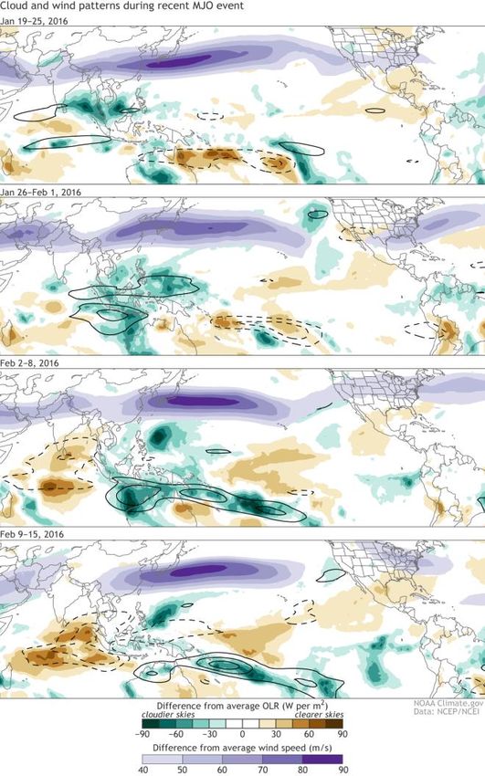
2018 Fall Outlook                                                                                   Albuquerque
 Sub-surface Temperatures                                                                             WEATHER FORECAST OFFICE

Figures 2 & 3. Sub-surface temperature anomalies at the equator. Sub-surface temperatures often precede the surface
temperatures by several months. An increasing amount of warmer than average water under the surface provides some additional
confidence in the fact climate models are forecasting a weak to moderate El Niño.

2018 Fall Outlook                                                                                      Albuquerque
 Where Are We Now Compared with Previous El Niño Events?                                                 WEATHER FORECAST OFFICE

Figure 4. Six short-lived El Niño events using the Multivariate El Niño Southern Oscillation Index since 1950. Four of the years
became moderate to strong El Niño events while one remained in neutral territory and one became a weak La Niña.
2018 Fall Outlook                                                                                       Albuquerque
                                                                                                          WEATHER FORECAST OFFICE
Madden-Julian Oscillation (MJO)

Figures 5 & 6. The MJO is an area of enhanced thunderstorms that travels around the world every 30 to 60 days from west to
east along/near the equator. Ahead and behind the active stormy area are areas of suppressed convection and drier conditions.
The MJO affects near-surface wind patterns, because the rising air in the stormy area causes surface winds to blow toward the
active area. The MJO can play a role in New Mexico’s weather at any time of year but it tends to have its greatest impacts during
the fall.The majority of forecast models for the third week in September bring the MJO into phase 8 (right image).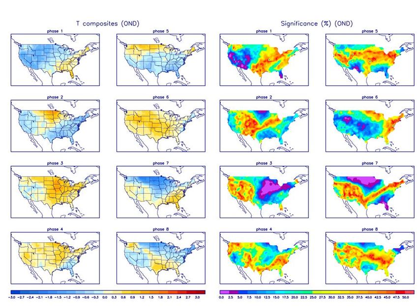
2018 Fall Outlook Albuquerque
WEATHER FORECAST OFFICE
Madden-Julian Oscillation (MJO) - Phases
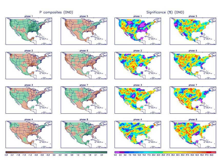
Figures 7 & 8. Temperature and precipitation anomalies during October, November, and December (OND) with each phase of the MJO. Note
the above average precipitation across northern New Mexico during phase 1 as well as the above average precipitation over western NM during
phases 8 and 2. Global model mean indicates that the MJO will strengthen as it transitions into phases 8 and then 1 during the third week of
September 2018.
2018 Fall Outlook                                                                                                                   Albuquerque
 Why the MJO is So Important?                                                                                                          WEATHER FORECAST OFFICE

Figure 9. Clouds and wind patterns for the MJO event that occurred from late-January to mid-February 2016. Black contours highlight the OLR (outgoing longwave
radiation, or heat energy) signals directly associated with the MJO. The MJO also affects the jet stream over the United States. When the MJO is over the Maritime
Continent (Indonesia, Philippines and Papua New Guiana), the jet stream typically shifts northward over the western part of the country and southward over the east.
That configuration leads to unseasonably warm temperatures in the west and cool temperatures in the east during the cool season. As the MJO moves eastward into
the Pacific, the Pacific jet weakens and the pattern over the U. S. flips.

2018 Fall Outlook                                                                                               Albuquerque
Aleutian Low - El Niño vs. La Niña                                                                              WEATHER FORECAST OFFICE

Recent El Niño Years                         Summer 2018                                 Recent La Niña Years

Figures 10-12. The Aleutian Low is a climatic feature centered near the Aleutian Islands on charts of mean sea level pressure
(MSLP). It represents one of the main ‘‘centers of action’’ in the atmospheric circulation of the Northern Hemisphere. The
Aleutian Low is most intense (lowest pressure) during winter and nearly disappears in summer (S.N. Rodionov et. al 2007). The
Aleutian Low remained near average strength over the Aleutian Islands since spring 2018, behaving as though the tropical Pacific
was in a neutral state. Typically, a stronger than average Aleutian Low in winter, leads to more frequent upper-level troughs for the
western United States.

2018 Fall Outlook                                                                                                    Albuquerque
                                                                                                                        WEATHER FORECAST OFFICE
 500mb Heights in Oct, Nov; El Niño vs. La Niña Years

   Recent El Niño Years                                                    Recent La Niña Years

Figures 13 & 14. 500mb height anomalies from recent El Niño and La Niña events during October and November. Note how tropical
convection influences upper-level highs an lows over the eastern Pacific Ocean and especially how it impacts the strength of the sub-tropical/Four
Corners’ high over the southwest U.S. A sub-tropical upper-level high over the southwest U.S. lasting well into meteorological fall during recent
La Niña events has resulted in well above-average temperatures in New Mexico and much of the southwestern U.S.
2018 Fall Outlook                                                                                                    Albuquerque
  “Analog” Years – 2002, 2004, 2006, 2014                                                                               WEATHER FORECAST OFFICE

Figures 15 & 18. Statewide temperature and precipitation for four recent weak to moderate El Niño events since 2000. Note that fall
temperatures were near average all four years while fall precipitation was near to above average in three of the years and below average in 2014 .
2018 Fall Outlook                                                                                                    Albuquerque
ENSO SST Predictions                                                                                                    WEATHER FORECAST OFFICE

Figure 19. The vast majority of both dynamical and statistical models indicate a weak to moderate El Niño by late fall or early winter . Current
atmospheric variables in the equatorial Pacific Ocean continue to reflect a neutral pattern but that should change in October and November.
2018 Fall Outlook                                                                                                    Albuquerque
 Oct-Nov Climate Model Forecasts - Precipitation                                                                        WEATHER FORECAST OFFICE

                                 OCT                                                                        NOV

Figures 20-27. Top two climate model precipitation rate skill percentages (top row) for October and November 2018. Model forecasts (bottom
row) are slightly above to above average with precipitation, particularly in October. Model forecasts for November are not much different, ranging
from near average to slightly above average.
2018 Fall Outlook Albuquerque
WEATHER FORECAST OFFICE
Oct-Nov Climate Model Forecasts - Temperature
OCT NOV
Figures 28-35. Climate model temperature anomaly plots from the two climate models which have the highest skill percentages for October
and November (top four images). Model forecasts (bottom four images) indicate slightly above average to above average temperatures during
both months.The temperature trend during autumn in New Mexico since around 1982 has been steadily increasing.2018 Fall Outlook Albuquerque Climate Prediction Center’s (CPC) SON/Fall Outlook WEATHER FORECAST OFFICE Figures 36 & 37. CPC agrees with the climate model consensus of higher than average chances for above average temperatures and above average chances for precipitation for central and western NM.
2018 Fall Outlook                                                                                                                            Albuquerque
 Different Flavors of El Niño                                                                                                                   WEATHER FORECAST OFFICE

Eastern Pacific El Niño (a.k.a. Cold Tongue, Conventional,   Central Pacific El Niño (a.k.a. Modoki, Warm Pool, or   Hybrid(s) - a continuum of different types
or Canonical El Niño)                                        Dateline El Niño)

Figures 38-40. The two main or most common El Niño flavors are the Eastern Pacific and Central Pacific. There are also hybrids
which are somewhere in the middle. Latest climate models continue to suggest a Central Pacific or Hybrid flavor.
2018 Fall Outlook                                                                                                    Albuquerque
 How About Wind and Precipitation During the First Two Weeks of October?                                                WEATHER FORECAST OFFICE

                                                                                                                                        Courtesy: Clay Anderson

                                        Courtesy: Bennie Boss

                                                                                   Courtesy: Steve Larese
                                     Courtesy: Clay Anderson

                                                                                                                                  Courtesy: Visit Albuquerque.org

While chances for precipitation in early October will be slightly above to above average, chances for strong wind events are below average .
2018 Fall Outlook Albuquerque Summary WEATHER FORECAST OFFICE Forecasts from the most highly skilled climate forecast models indicate that precipitation in central and northern New Mexico during October and November 2018 will most likely range from near to above 1981-2010 climatological averages. Climate model forecasts along with recent temperature trends indicate that temperatures in central and northern New Mexico during October and November 2018 will most likely range from slightly above to above average.
2018 Fall Outlook Albuquerque
WEATHER FORECAST OFFICE
Outlook Information
References
• Rodionov, S.N., Overland, J.E., Bond, N.A., 2007. The Aleutian Low, storm tracks, and winter climate
variability in the Bering Sea. Deep-Sea Research II 54 (2007) 2560–2577.
Outlook provided by National Weather Service Forecast Office Albuquerque, NM.
For further information contact Andrew Church: andrew.church@noaa.gov (505)
244-9150You can also read