2018 TIGER CONFERENCE - POST-CONFERENCE FIELD TRIP GUIDE THE LEEUWIN COMPLEX WESTERN AUSTRALIA
←
→
Page content transcription
If your browser does not render page correctly, please read the page content below
2018 TIGeR
CONFERENCE
Coupling between Metamorphism and Deformation

Post-Conference
Field Trip Guide
The Leeuwin Complex
Western Australia
15-17 September 2018

Make tomorrow better.
2018 TIGeR Conference                                                                                    Post-conference field trip guide

    Curtin University, Perth, Western Australia
    12-14 September 2018

Post-conference Field Trip Guide: The
Leeuwin Complex, Western Australia
Saturday 15th to Monday 17th September, 2018

Nicholas E. Timms1
email n.timms@curtin.edu.au
With contributions from Ian Fitzsimons1, Paul Wilkes2, Tim Johnson1, David Pearce1,3, Chris Tucker1,
Sarah Arnoldi1, Hugo Olierook1, and Steven Reddy1.
1   Curtin University, Perth, GPO Box U1987, Western Australia
2   CSIRO, Perth, Western Australia
3   CMW Geosciences, Australia

    Cape Leeuwin waterwheel (image = Nick Timms)

Table of Contents
Welcome to southwest Western Australia ................................................................................................. 2
Evolution of the southwestern margin of Western Australia ...................................................................... 4
The southwestern Yilgarn Craton.............................................................................................................. 4
The Darling Fault Zone ............................................................................................................................. 4
Pinjarra Orogen......................................................................................................................................... 5
Northampton and Mullingarra Complexes ................................................................................................. 7
The Leeuwin Complex .............................................................................................................................. 7

                                                                      Page 1 of 50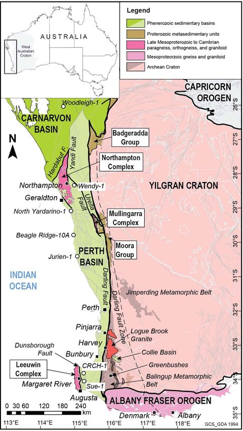
2018 TIGeR Conference                                                                                     Post-conference field trip guide

Geochronology of Perth Basin Basement Well Intersections ....................................................................9
Offshore extent of the Leeuwin Complex ..................................................................................................9
A new view of the Leeuwin Complex from aeromagnetics ........................................................................9
Overview and Subdivision into Domains .................................................................................................11
Field observations – magnetic susceptibility ...........................................................................................11
Structural geology ...................................................................................................................................14
Assembly of the Leeuwin Complex .........................................................................................................14
New zircon U-Pb geochronology, REE and Lu-Hf isotope data from the Leeuwin Complex ...................18
Tectonic evolution of the Leeuwin Complex ............................................................................................19
Gondwana Break-up: Rifting of the Perth Basin and Southern Rift System ............................................21
Southern Perth Basin ..............................................................................................................................22
The record of rifting in the Leeuwin Complex ..........................................................................................22
Bunbury Basalt – Flow Geometry and Timing with Respect to Continental Break-up .............................23
Where are the rifted correlatives of the Leeuwin Complex now? ............................................................26
Field localities..........................................................................................................................................28
Cape Leeuwin, Yallingup Domain, Leeuwin Complex .............................................................................28
Redgate Beach, Redgate Domain, Leeuwin Complex ............................................................................32
Wilyabrup Cliffs, Gracetown/Yallingup Domain, Leeuwin Complex.........................................................34
Canal Rocks, Smiths Point, Yallingup Domain, Leeuwin Complex .........................................................36
Sugar Loaf Rock, Yallingup Domain, Leeuwin Complex .........................................................................37
Shelley Cove, Naturaliste Domain, Leeuwin Complex ............................................................................39
Bunbury Basalt, Casuarina Point, Bunbury, Perth Basin.........................................................................41
References ..............................................................................................................................................43
Notes and Doodles..................................................................................................................................48

    Welcome to southwest Western Australia
    The objective of this field trip is to discuss the geological evolution of the southwestern-most corner of
    Australia. On this trip, we will focus on the coastal outcrops of the Mesoproterozoic to Cambrian
    crystalline rocks of the Leeuwin Complex in the southwestern-most corner of Australia. We will explore
    the role of this enigmatic puzzle piece in the assembly and breakup of Gondwana, showcasing new
    interpretations based on recent geophysical imagery, geochronology, and field data. We may also visit
    outcropping lava flows of the Bunbury Basalt within the Perth Basin, which represent the first vestiges
    of continental breakup. Several previous field guides have focussed on this region (Myers, 1994;
    Nelson, 1995; Wilde and Nelson, 2001; Janssen et al., 2003; Freeman and Donaldson, 2006, 2008;
    Timms, 2017, 2018). The aim of this field guide is to provide updates of some key data and recent
    findings, contemporary views, and potential future research directions. It showcases new
    interpretations based on geophysical imagery, geochronology and mapping, and explores the
    assembly and breakup of eastern Gondwana. A thorough review on the historical development of ideas
    is not offered to keep this document succinct. Readers are directed elsewhere for detailed reviews,
    e.g., Myers (1990c), Iasky (1993), Harris (1994b), Wilde and Murphy (1990), Fitzsimons (2003), and
    Janssen et al. (2003). Research in the area is ongoing, and a variety of new data are currently being
    acquired. Consequently, some ideas summarized here may be subject to change, even since I wrote
    this field trip guide!
    The Leeuwin Complex is situated in the heart of the Margaret River region, famous for fine wine, world-
    class surfing, whale watching, and beautiful Karri forests. I hope that you enjoy the trip! Nick Timms

                                                                       Page 2 of 50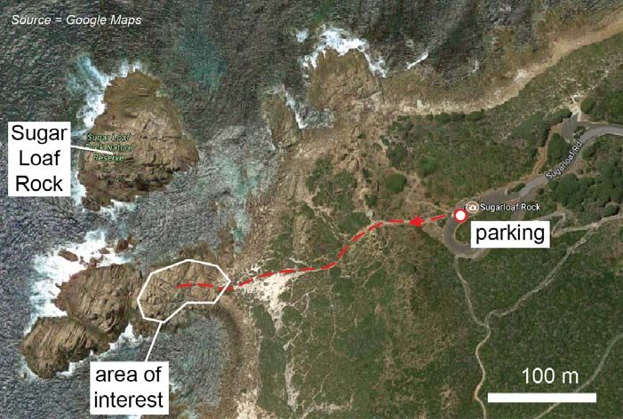
2018 TIGeR Conference                                                Post-conference field trip guide

  Figure 1. Simplified map of the bedrock geology of southwest Western Australia showing major
  tectonic subdivisions. After Wilde and Nelson (2001), Janssen et al. (2003) and Markwitz et al.
  (2017). The Pinjarra Orogen comprises components labeled by white boxes.

                                              Page 3 of 50
2018 TIGeR Conference                                                     Post-conference field trip guide

                                                             are visible on the Yilgarn Craton adjacent to the
Evolution of the                                             western Albany-Fraser Orogen. NW-SE, E-W and
southwestern margin of                                       ENE-WSW sets that are attributed to the Boyagin,
                                                             Gnowangerup, and Fraser dyke swarms,
Western Australia                                            respectively, plus a WNW-ESE trending set that is
The region along the western margin of the                   unassigned (Myers, 1990a; Harris and Li, 1995).
Archean Yilgarn Craton - what now forms the                  These dykes yield ages of ca.1218 Ma to ca. 1202
western seaboard of Western Australia - has                  Ma (Evans, 1999; Qiu et al., 1999; Wingate et al.,
undergone numerous major geological events,                  2000; Pidgeon and Nemchin, 2001; Pidgeon and
including multiple episodes of continental                   Cook, 2003; Rasmussen and Fletcher, 2004;
amalgamation and break-up (Collins, 2003).                   Wingate and Kirkland, 2011; Pisarevsky et al.,
However, there are aspects of the geological                 2014), and are contemporaneous with events of
history that are still not well understood. This in          Stage II of the Albany-Fraser Orogen to the south
part is due to the limited exposures: The Yilgarn            (Spaggiari et al., 2014).
Craton is poorly-exposed, adjacent crystalline
rocks outcrop only in three widely-spaced inliers            The Darling Fault Zone
(Northampton,       Mullingarra      and    Leeuwin
Complexes) (Myers, 1990c), and the onshore                   A westward increase in abundance of ~N-S
Perth Basin is mostly veneered by Quaternary to              trending, ribbon-like mylonite and ultramylonite
recent deposits (Playford et al., 1976) (Figs 1 and          zones indicates a general increase in strain
2). Furthermore, the rifted geological counterparts          towards the Darling fault, which bounds the
to southwest Western Australia are buried under              western edge of the Yilgarn Craton (Wilde, 1999;
ice sheets in Antarctica, subducted beneath Tibet,           Wilde and Nelson, 2001) (Fig. 1). Along the
or covered by alluvial and fluvial systems in India.         soutwestern margin of the Yilgarn Craton, high
Consequently, the rocks of southwestern Western              strain zones up to 10 km wide are interpreted to be
Australia continue to attract attention because they         part of a crustal-scale sinistral ductile shear zone,
represent important puzzle pieces due to the                 known as the Darling Fault Zone, that was
unique position that they occupy, the protracted             periodically reactivated during the Proterozoic,
geological history that they record, and their role in       and along which the brittle(?) Darling Fault
paleo-continent reconstructions (Norvick et al.,             nucleated with normal sense during the
2001; Fitzsimons, 2003; Veevers et al., 2007;                Phanerozoic (Dentith et al., 1993; Harris, 1994a;
Boger, 2011; Williams et al., 2011; White et al.,            Beeson et al., 1995; Wilde and Nelson, 2001).
2013; Aitken et al., 2016; Morrissey et al., 2017;
                                                             The southern margin of Yilgarn Craton is bound by
Tucker et al., 2017).
                                                             the Proterozoic (ca. 1850-1100 Ma) Albany-Fraser
                                                             Orogen (Fig. 1). No rocks of Albany-Fraser affinity
The southwestern Yilgarn                                     have been demonstrated to occur onshore west of
                                                             the Darling Fault. The entire Albany-Fraser
Craton                                                       Orogen is deflected southward in an apparent
                                                             sinistral sense by the Precambrian Darling Fault
The South West Terrane of the Yilgarn Craton has
                                                             Zone (Fig. 1). Even though this relationship is
a rich history and has been subdivided into three
                                                             clearly visible on aeromagnetic images, exposed
metamorphic belts, from southwest to northeast
                                                             N-S trending Albany-Fraser rocks is limited to very
these are the Balingup, Chittering and Jimperding
                                                             weathered        outcrops      Windy       Harbour.
Metamorphic Belts (Fig. 1) (Wilde, 1999; Wilde
                                                             Nevertheless, protolith and metamorphic age
and Nelson, 2001). Metasedimentary rocks and
                                                             constraints from rocks of the Albany-Fraser
orthogneiss in the Balingup zone have undergone
                                                             Orogen to the east mean that sinistral ductile
amphibolite facies metamorphism, the age of
                                                             shearing associated with the Darling Fault Zone
which is poorly constrained, but is considered to
                                                             must be younger than ca. 1100 Ma.
be > ca. 2838 Ma (Wilde and Nelson, 2001). These
                                                             Recrystallization and resetting of 40Ar/39Ar ages of
rocks are intruded by granitoids of the 2612 ± 5 Ma
                                                             micas from Archean rocks on the western margin
Logue Brook Granite, 2647 to 2613 Ma Darling
                                                             of the Yilgarn Craton in the vicinity of Perth
Range Batholith and the ca. 2828 to 2740 Ma
                                                             preserve ages down to ca. 620 Ma adjacent to the
Gibraltar Quartz Monzonite (Compston et al.,
                                                             Darling Fault to ca. 1320 Ma up to 40 km to the
1986; Nemchin and Pidgeon, 1999; Wilde, 1999;
                                                             east (Lu et al., 2015) (Fig. 3). The southwest
Wilde and Nelson, 2001) (Fig. 3). Intrusion of
                                                             Yilgarn and Albany-Fraser Orogen have been
syntectonic pegmatites occurred at ca. 2577-2527
                                                             susceptible to resetting of the Rb-Sr system in
Ma, with the shear zone-hosted Greenbushes
                                                             biotite to as young as ca. 405 Ma in the vicinity of
Pegmatite, south of Balingup, forming the world’s
                                                             the town of Harvey (Libby and de Laeter, 1998)
most significant lithium and tantalum deposits
                                                             (Fig. 3).
(Partington et al., 1995; Wilde and Nelson, 2001;
Freeman and Donaldson, 2008).
The southwestern Yilgarn Craton has been
intruded by several sets of mafic dyke swarms, the
earliest being the 2418 ± 3 Ma E-W trending
Widgemooltha Dyke Swarm (Nemchin and
Pidgeon, 1998). Four other intersecting swarms

                                                   Page 4 of 50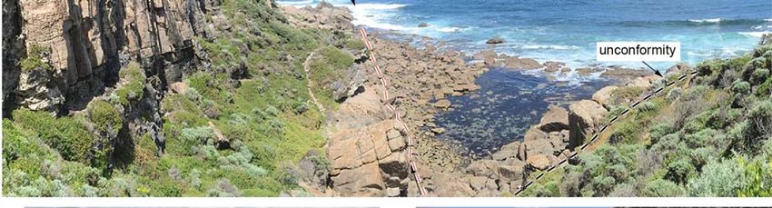
2018 TIGeR Conference                                                      Post-conference field trip guide
                                                                                        Figure 2.
                                                                                        Geological map
                                                                                        of southwestern
                                                                                        Western
                                                                                        Australia
                                                                                        showing the
                                                                                        location of the
                                                                                        Leeuwin
                                                                                        Complex. After
                                                                                        Playford et al.
                                                                                        (1976).

                                                              referred to as the Proto-Pinjarra Orogen (Myers et
Pinjarra Orogen                                               al., 1996). Lu et al. (2015) subdivided the Pinjarra
                                                              Orogen into two orogenic events: Stage I (Pinjarra
Basement rocks to the west of the Darling Fault               Orogeny) between ca. 1000-1270 Ma; and Stage
from the southern coast of Australia over 1500 km             II (Leeuwin Orogeny) between ca. 500810 Ma.
north are exclusively Proterozoic to Cambrian in              However, the exact nature of tectonic activity
origin, were once referred to as the Darling Mobile           during this time will be a topic of discussion during
Belt (Harris, 1994a; Wilde and Nelson, 2001), and             the trip.
are more generally known as the Pinjarra Orogen
(Myers, 1990c). Later, the Pinjarra Orogen was
defined to refer specifically to accretion of a belt of
terranes to the western margin of the Yilgarn
Craton and reworking of the Yilgarn margin during
Neoproterozoic to Cambrian times (Myers et al.,
1996; Fitzsimons, 2003; Janssen et al., 2003) (Fig.
1). These authors make the distinction that the
terranes that were accreted have an older history,
which they interpret to be unrelated to accretion
event associated with the Pinjarra Orogen, sensu
stricto. Events ca. 1100-1000 Ma have been

                                                    Page 5 of 50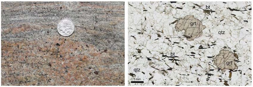
2018 TIGeR Conference                                              Post-conference field trip guide

     Figure 3. Compilation of geochronological data for the southwest Western Australia.

                                            Page 6 of 50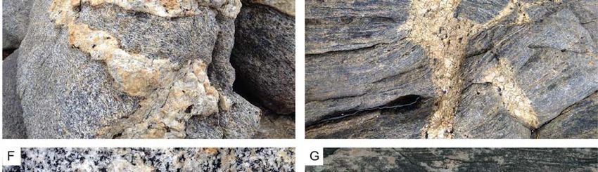
2018 TIGeR Conference                                                  Post-conference field trip guide

Outcrops of the Pinjarra Orogen are restricted to          of Western Australia. Its onshore expression is
three fault-bound basement inliers – referred to as        approximately 20 km wide, and is bound to the
the Northampton, Mullingarra, and Leeuwin                  east by the Dunsborough Fault, a normal fault that
Complexes, and low-grade metasedimentary                   juxtaposes the Leeuwin Complex with the Vasse
rocks of inferred Proterozoic age that                     Shelf of the Perth Basin. The Leeuwin Complex
unconformably overlie the Yilgarn Craton and               continues offshore to the north, west and south,
Mullingarra Complex to the north of Perth (Myers,          where it is obscured and draped by sediments
1990c) (Fig. 1). Elsewhere, the Pinjarra Orogen is         (Fig. 2).
covered by sedimentary rocks of the Perth Basin,
and only a small number of petroleum exploration           Outcrops of the Leeuwin Complex are generally
wells have intersected basement rocks (Fletcher            limited to coastal headlands, with small patchy,
et al., 1985; Fletcher and Libby, 1993; Bodorkos et        isolated outcrops inland. Elsewhere onshore, the
al., 2016; Markwitz et al., 2017) (Figs 1 and 3).          Leeuwin Complex is veneered by Cenozoic to
                                                           recent sediments (Playford et al., 1976) (Fig. 2).
                                                           The rocky headlands of the Leeuwin Complex and
Northampton and                                            intervening beaches pick up swell from the
                                                           Southern and Indian Oceans, and the region is
Mullingarra Complexes                                      renown for hosting world surf tournaments, such
Two of the three inliers of the Pinjarra Orogen            as the ‘Margaret River Pro’. Inland, remnant
share similar geological characteristics. The              patches of magnificent Karri forests endure among
Northampton and Mullingarra Complexes are                  predominantly agricultural land use. Well-drained
located near the towns of Geraldton and Three              soils and the local climate have seen the
Springs, respectively, and have been described in          establishment of this region, known as the
detail by Myers (1990c) (also see Janssen et al.           Margaret River Region, for producing world-class
(2003) for a summary). The Northampton and                 wines. A combination of fine wine, pristine
Mullingarra Complexes predominantly comprise               beaches warmed by the Leeuwin Current, good
psammititic paragneiss, metapelite, quartzite and          fishing, and excellent surf breaks are largely
mafic gneiss. The detrital provenance of these             responsible for the popularity of the Cape to Cape
metasedimentary units is generally upon as the             region with tourists.
Albany-Fraser      Orogen      (Fitzsimons,    2003;       Eolianites of the Pleistocene Tamala Limestone
Ksienzyk et al., 2012). SHRMIP U-Pb detrital               are prevalent along coastal areas, reaching
zircon age spectra show populations at 1900-1600           thicknesses of ca. 330 m in places and commonly
Ma and 1400-1150 Ma in both complexes, with a              deposited unconformably on the gneisses of the
maximum depositional age of 1113 ± 26 Ma (Cobb             Leeuwin Complex (Playford et al., 1976).
et al., 2001; Ksienzyk et al., 2012) (Fig. 3). These       Hundreds of caves have been dissolved out of
ages are consistent with source rocks of either the        these units, and a handful of them are open to the
Albany-Fraser or Capricorn Orogens (Fitzsimons,            public as show caves. Some of the caves have
2003; Spaggiari et al., 2011; Ksienzyk et al., 2012;       exploited the unconformity, providing an additional
Spaggiari et al., 2014). Metamorphism reached              opportunity to access the Leeuwin Complex
granulite facies at 1079 ± 3 in the Northampton            beneath.
Complex and peak amphibolite facies conditions
at 1079 ± 32 Ma in the Mullingarra Complex,                The Leeuwin Complex mainly comprises of
shown by SHRIMP U-Pb zircon analyses                       interleaved orthogneiss of felsic, intermediate and
(Bruguier et al., 1999; Cobb et al., 2001).                mafic composition, which is dissimilar to the
                                                           Northampton and Mullingarra Complexes to the
The     Mullingarra     Complex       hosts    an          north. Many different lithological classification
unmetamorphosed monzogranite with a zircon                 schemes based on different criteria have been
population of 2181 ± 10 Ma (Cobb et al., 2001).            developed over time, which can serve to confuse
Felsic magmatism in the Northampton Complex is             when comparing studies (Janssen et al., 2003).
represented by a 1068 ± 13 Ma granite pluton and           The relatively simple grouping into units of the
pegmatite dyke emplacement at 989 ± 2 Ma                   mafic-dominated      Cowaramup        Gneiss    and
(Bruguier et al., 1999) (Fig. 1). A N-NE trending          deformed granitoid Hamelin Granite by Myers
mafic dyke swarm intruded the Northampton                  (1994) was adopted by Collins (2003). More
Complex at ca. 750 Ma (Embleton and Schmidt,               complex classification schemes were developed
2007), and has been correlated with the Mundine            based on mineralogical criteria, resulting in six
Well dyke swarm in the Pilbarra Craton (Wingate            ‘types’ of gneiss (Wilde and Murphy, 1990;
and Giddings, 2000), but could possibly be                 Murphy, 1992). In places, igneous protoliths can
associated with the similar-trending Muggamurra            be inferred confidently from the preservation of
dyke swarm on the Yilgarn Craton (Janssen et al.,          primary textures and mineralogy (Myers, 1990b;
2003). No mafic dykes have been identified in the          Collins, 2003). However, the effects of deformation
Mullingarra Complex.                                       and metamorphism can be variable, interleaving
                                                           can occur on different scales and migmatitic
                                                           textures are common, which can make field
The Leeuwin Complex                                        mapping based on protolith types difficult.
The Leeuwin Complex, which is a focus of this field        Gneisses of all compositions preserving variable
trip, forms the crystalline basement of the Cape           proportions and geometries of leucosomes along
Leeuwin to Cape Naturaliste in the far southwest           strike and across strike. Granitoid pegmatites can

                                                 Page 7 of 50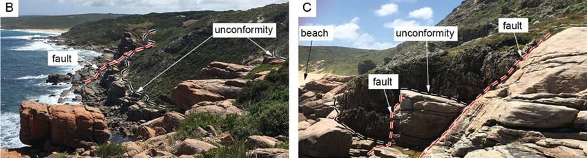
2018 TIGeR Conference                                                     Post-conference field trip guide

occur as planar dykes on the order of a few                  °C (Stoltze, 2000) and 5 kbar and 650-750 °C
centimetres to tens of centimetres wide that cross           (Murphy, 1992) in the northern Leeuwin Complex.
cut most structures, or as nebulous blobs, some              It has been proposed that the southern Leeuwin
instances with ambiguous relationships to smaller-           Complex did not reach granulite facies conditions
scale leucosomes. Conspicuous sharply-bound,                 (Wilde and Murphy, 1990), whereas the
black mafic bands generally much less than a                 prevalence of amphibolite facies assemblages
metre in thickness are occasionally found                    could simply reflect widespread retrogression of
interspersed with other gneisses, interpreted as             granulites (Myers, 1994).
the metamorphosed and deformed remnants of
mafic dykes (Myers, 1990b; Wilde and Murphy,                 The timing of events in the Leeuwin Complex has
1990; Simons, 2001; Collins, 2003).                          been constrained by SHRIMP U-Pb zircon,
                                                             hornblende 40Ar/39Ar geochronology, and whole-
Until recently, the deformation history of the               rock Sm-Nd analysis (Fletcher et al., 1985; Wilde
Leeuwin Complex has been developed from                      and Murphy, 1990; Fletcher and Libby, 1993;
detailed structural mapping of disjointed coastal            Nelson, 1996, 1999; Nelson, 2002; Collins, 2003;
outcrops (Myers, 1990b; Murphy, 1992; Collins,               Fitzsimons, 2003; Janssen et al., 2003) (Figs 3
2003; Harris, 2003; Janssen et al., 2003). A                 and 4a). The meaning of the data is still a matter
sequence of five deformation events (D1 to D5) in            of debate, and the subject of ongoing research
the northern Leeuwin Complex and four (D1 to D4)             (Arnoldi, 2017; Arnoldi et al., 2017). The earliest U-
in the southern Leeuwin Complex has been                     Pb zircon ages are recorded from garnet-bearing
suggested (Janssen et al., 2003). Structures                 gneisses in the central Leeuwin Complex, and are
assigned to these events are outlined below:                 ca. 1090 Ma, interpreted as magmatic
                                                             crystallisation ages of the protoliths (Nelson, 1999;
D1 is taken to be the prominent gneissic foliation           Janssen, 2001; Janssen et al., 2003). A younger
(S1) and parallel lithological layering across the           group of U-Pb zircon analyses from rocks
Leeuwin Complex. However, it is acknowledged                 elsewhere define a spread of ages between ca.
that D1 might not represent an initial deformation           780 and ca. 680 Ma (Nelson, 1996, 1999; Nelson,
stage given that this foliation is axial planar to           2002; Collins, 2003). The final episode recorded
centimetre- to metre-scale, often rootless isoclinal         by U-Pb zircon system is ca. 540-520 Ma (Wilde
fold (F1) hinges. Leucosomes can be strongly                 and Murphy, 1990; Collins, 2003). Lack of textural
parallel or weakly aligned with S1. Asymmetric               context for analyses in early studies (Nelson,
kinematic indicators in S1 are typically either              1996, 1999; Nelson, 2002) make the exact cause
absent or have inconsistent shear senses.                    of the spread of ages difficult to interpret:
D2 is represented by north-trending, typically km-           potentially representing long-lived / repetitive
wavelength folds (F2) that deform the D1 foliation.          igneous activity, metamorphic overgrowth or
These folds plunge gently to moderately northward            disturbance events, or some combination of these.
in the northern Leeuwin Complex, and are tight               Nevertheless, Collins (2003) used textures and
with a steep northerly plunge in the southern                compositional criteria to interpret zircon
Leeuwin Complex. An L12 intersection lineation               overgrowths are metamorphic and occurred ca.
can be observed in the northern Leeuwin                      525 Ma during an event that signifies the collision
Complex.                                                     between Australia and India.
D3 is interpreted to be a late folding event (F3) that       Orthogneisses with 780-680 Ma protoliths
does not result in new foliations or lineations. An          exposed in the Leeuwin Complex preserve
ENE-trending F3 fold has been inferred to explain            Mesoproterozoic whole-rock Sm-Nd TDM model
a girdle distribution of F2 fold hinges at Cape              ages, ranging from 1499 to 1141 Ma (McCulloch,
Naturaliste (Collins, 2003). In the southern                 1987; Black et al., 1992; Fletcher and Libby, 1993;
Leeuwin Complex, D3 is manifest as gentle folds              Fitzsimons, 2003; Bodorkos et al., 2016) (Fig. 3).
with ~10 km wavelengths (Janssen et al., 2003),              This is considerably younger than TDM model ages
and open folding of S1 in the northern Leeuwin               of orthogneisses and granitoids of the
Complex is attributed to D4.                                 Northampton Complex (2094-2060 Ma) and
                                                             suggests juvenile input (Bodorkos et al., 2016).
Brittle faulting of various scales and orientations          However, the relationship between these rocks
has been allocated to D4 in the southern Leeuwin             and the ca. 1090 Ma rocks in the Leeuwin
Complex and D5 in the northern Leeuwin Complex               Complex remains unclear, and is the subject of
in the scheme of (Janssen et al., 2003). More                ongoing research (Arnoldi, 2017; Arnoldi et al.,
recently, detailed field mapping has been                    2017) and discussion on this field trip.
combined with interpretation from aeromagnetic
imagery to resolve the architecture of the Leeuwin           Whole-rock geochemistry has been used in
Complex and develop a framework for its structural           conjunction with geochronological data to unravel
components (Pearce, 2014; Tucker, 2014). This                the magmatic history of the protoliths (Wilde and
will be discussed in detail below and during the             Murphy, 1990; Nelson, 1996; Wilde, 1999; Collins
trip.                                                        and Fitzsimons, 2001). The ca. 1090 Ma gneisses
                                                             plot as syn-collisional granites on the Rb/Yb+Ta
The Leeuwin Complex was metamorphosed to                     granite discrimination diagram of Pearce et al.
upper-amphibolite to granulite facies conditions.            (1984) and have S-type geochemistry, whereas
Thermobarometric      estimates      for    peak             the 780-680 Ma suite can be classified as A-type
metamorphism include 6.85-7.6 kbar and 784-800               granites, and have a ‘within-plate’ affinity (Collins

                                                   Page 8 of 50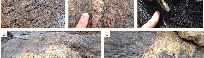
2018 TIGeR Conference                                                    Post-conference field trip guide

and Fitzsimons, 2001). The 790-680 Ma protoliths
have been interpreted to have been emplaced in
                                                            Offshore extent of the
an extensional environment relating to the break-           Leeuwin Complex
up of Rodinia (Wilde, 1999).
                                                            The western extent of the Leeuwin Complex is not
                                                            well constrained. Continental fragments, such as
Geochronology of Perth Basin                                the Naturaliste Plateau and Gulden Draak, have
                                                            been recognised to the west of the Leeuwin
Basement Well Intersections                                 Complex (Borissova, 2002; Halpin et al., 2008;
The handful of wells drilled in the Perth Basin that        Gardner et al., 2015). Geochronology of the
intersected basement provide additional glimpses            closest dredge samples to the Leeuwin Complex,
of the hidden part of the Pinjarra Orogen. Whole-           taken over 500 km offshore on the Naturaliste
rock Sm-Nd data collected from bottom-of-hole               Plateau, gives insights into its affinity (Borissova,
granitoids and felsic orthogneisses in five wells by        2002; Halpin et al., 2008; Gardner et al., 2015).
Fletcher et al. (1985) and Fletcher and Libby               Zircon cores from granite and felsic orthogneiss
(1993) were recalculated by Fitzsimons (2003). In           yielded LA-ICPMS U-Pb ages of returned ca. 1180
the north, granitoid and felsic orthogneiss from            Ma, interpreted to represent emplacement age of
Jurien-1 and N Yardarino-1 drill core yielded TDM           the protoliths (Halpin et al., 2008) (Fig. 3). These
model ages of 2234 Ma and 2078 Ma,                          authors suggested that these rocks have a
respectively. Felsic orthogneiss from ~3074 m in            stronger genetic affinity to the Albany-Fraser
Sue-1 (drilled on the Vasse Shelf adjacent to the           Orogen than the Pinjarra Orogen. Monazite and
Leeuwin Complex), CRA CRCH-1, and Treeton                   one zircon rim analysis from the same samples
DDH-1 yielded TDM ages of 2040 Ma, 2002 Ma,                 yielded ages of 515 ± 5 Ma and ca. 510 Ma,
and 1996 Ma, respectively (Fitzsimons, 2003;                respectively (Halpin et al., 2008) (Fig. 3). Along
Bodorkos et al., 2016) (Fig. 3).                            with ca. 508 Ma 40Ar/39Ar ages from felsic gneisses
                                                            reported by Borissova (2002), these younger ages
Recent SHRIMP U-Pb zircon geochronology from                are broadly coeval with metamorphic zircon
Sue-1 drill core indicates a complex age spectra,           growth in the Pinjarra Orogen, and are interpreted
with an upper intercept of 1076 ± 35 Ma interpreted         to represent the tectonic suture of India and
as the emplacement age (Bodorkos et al., 2016).             Australia-Antarctica during the assembly of
A poorly-constrained lower intercept of 680 ± 110           Gondwana (Fitzsimons, 2003; Halpin et al., 2008).
Ma was interpreted as post-crystallisation
disturbance, potentially linked to an early
Cambrian (540-520 Ma) event recorded across the             A new view of the Leeuwin
Pinjarra Orogen (Collins, 2003; Bodorkos et al.,
2016) (Fig. 3).                                             Complex from aeromagnetics
In the north, basement samples from Beagle Ridge            The spatially restricted and disjointed nature of the
10A and Wendy-1 have been investigated by                   coastal outcrops has hampered resolution of the
SHRIMP U-Pb zircon geochronology (Bodorkos et               structural architecture of the Leeuwin
al., 2016; Markwitz et al., 2017). Zircon from felsic
orthogneiss in Beagle Ridge-10A yielded a
weighted mean 207Pb/206Pb age of 1092 ± 27 Ma
interpreted as a magmatic crystallization age
(Bodorkos et al., 2016) (Fig. 3).
Zircon in a paragneiss recovered from Wendy-1
preserves rims with a 207Pb/206Pb Concordia age
of 526.3 ± 12 Ma, interpreted as a metamorphic
overgrowth event (Markwitz et al., 2017). Zircon
cores preserve a wide range of ages, with
concordant analyses ranging from 2845 ± 14 Ma
(a single analysis) to ca. 1065 Ma and notable
peaks at ca. 1119 Ma, ca. 1211 Ma, and ca. 1533
Ma (Markwitz et al., 2017) (Fig. 3).
The drill core geochronological data are consistent
with data from the three inliers, which supports the
concept that a belt of isotopically-coherent
Paleoproterozoic crust occupies the full length of
the Pinjarra Orogen inboard of the Leeuwin
Complex (Bodorkos et al., 2016). The exception
seems to be the somewhat more juvenile protoliths
of the Leeuwin Complex.

                                                  Page 9 of 50
2018 TIGeR Conference Post-conference field trip guide
Figure 4. A. Isostatic residual gravity image. Geochronology localities based on zircon U-Pb data from
Wilde and Murphy (1990); Nelson (1996); Nelson (1999); Nelson (2002); Collins (2003); Janssen et al.
(2003), and hornblende 40Ar/39Ar ages from Nelson (2005). Zircon rim U-Pb ages in blue text. B. Reduced
to pole (RTP) aeromagnetics image. C. Vertical gradient of reduced to pole aeromagnetic image. D.
Composite aeromagnetics image (overlay of B and C). See text for discussion of the subdivision into
domains.
Page 10 of 502018 TIGeR Conference Post-conference field trip guide
Complex. This lack of context has led to difficulties Regional (kilometre-scale) folds and, in some
in gauging the significance of outcrop-scale cases, refolded folds are readily identifiable within
structures at the regional scale, and in their in the Naturaliste, Yallingup and Gracetown
correlation to produce a unified deformation Domains (Fig. 4).
history of the entire Leeuwin Complex, as flagged
by (Janssen et al., 2003). The boundaries between domains are distinct and
commonly truncate the folds within domains.
The acquisition of high-resolution geophysical Discrete, low-magnetic narrow linear features are
data (Fig. 4) by the Geological Survey of Western clearly visible that cut across the domains
Australia in 2011 has provided a unique obliquely (typically trending NE-SW, with minor
opportunity to assess the architectural make-up NW-SE, E-W and N-S occurrences), displace
and nature of the ductile and brittle structures of folded bands and coincide with faults inferred from
the Leeuwin Complex in far greater detail than was detailed mapping (Fig. 4) (Collins, 2003).
previously possible (Pearce, 2014; Tucker, 2014).
The aeromagnetic data reveal a wealth of regional
scale fold and fault structures that were previously Field observations – magnetic
unknown or poorly understood due to lack of
exposure and/or cover of much younger rocks. A
susceptibility
new interpretation of the Leeuwin Complex using Lithological and structural field mapping of
the aeromagnetic data and field data. This accessible coastal and inland exposures of the
provides a context in which to place all existing Leeuwin Complex at 1:3,000 to 1:5,000 scale was
legacy data as well as a framework for the tectonic integrated with aeromagnetic images (e.g., Fig. 5).
development of the Leeuwin Complex and its role Magnetic susceptibility measurements were made
in the evolution of the Pinjarra Orogen. in the field to characterise their magnitude and
heterogeneity within mappable geological units
and ‘ground-truth’ the aeromagnetic imagery (Fig.
Overview and Subdivision 5). The complete dataset, totalling 2,920 survey
into Domains points, and details of the transect locations and
rock types are summarised in Fig. 6.
New interpretations by Pearce (2014) and Tucker
(2014) utilised isostatic residual gravity data The in situ magnetic susceptibilities measured
(GSWA Record 2004/14) and the most recently from a variety of lithologies across the Leeuwin
acquired aeromagnetic survey data (survey Complex span five orders of magnitude, and
P1244), collected in 2011 by Fugro for the approximately correlate with the full range seen in
Geological Survey of Western Australia (Fig. 4). the RTP aeromagnetic image (Fig. 6). The broad
The survey was flown at 60 m ground clearance, division of rock types into groupings of mafic-
400 m spaced east–west flight lines and 4 km intermediate composition, intermediate-felsic
spaced north–south tie lines. The isostatic residual composition and felsic composition, corresponds
gravity image was used to help define the position to an approximate in situ field classification of ≥ 20
of major faults, such as the Dunsborough Fault % mafic minerals, between 20 % and 5 % mafic
along the eastern margin of the Leeuwin Complex, minerals and ≤ 5 % mafic minerals, respectively.
although this structure is clear enough on The mafic-intermediate group tend to be variable
aeromagnetic imagery (Fig. 4). The deep-seated mixtures of granitoid to intermediate protoliths,
Dunsborough Fault juxtaposes the low and amphibolite and/or mafic granulite. Generally, the
smooth magnetic signature of the Perth Basin to mafic-intermediate rocks (equivalent to grey
the east from the generally highly magnetic yet granodiorite gneiss of Collins (2003)) possessed
heterogeneous response of the Leeuwin Complex the highest percentage of magnetite and shows
immediately to the west. relatively homogeneous dispersion throughout the
Aeromagnetic characteristics are variable across rock. The magnetite is concentrated within the
the Leeuwin Complex, and four distinct domains restite margins of leucosome bands and/or is
based on aeromagnetic intensity and ‘texture’ found as sub-euhedral mats or large
have been defined (Fig. 4D). From east to west, porphyroblasts (0.5–15 cm) within the minor
these have been named the Naturaliste, Yallingup, pegmatite bodies that intrude these rocks.
Gracetown and Redgate Domains, respectively. However, minor pegmatite dykes with planar to
The Naturaliste Domain is characterised by NNW– irregular margins that are discordant to the
SSE trending linear features of high to very-high gneissic foliation occur in all rock types, and are
aeromagnetic intensity. The Yallingup Domain predominantly not magnetite-bearing and have
contains well-defined continuous bands low magnetic susceptibility. Dark grey to black
alternating between high- and low-aeromagnetic amphibolite (± biotite, ± orthopyroxene, ±
response. The Gracetown Domain has a similar
appearance to the Yallingup Domain, but has
lower magnetic response. The Redgate Domain is
somewhat different in that it generally has a
smooth aeromagnetic texture with broad gradients
in magnetic intensity. Only a small portion of this
latter domain is onshore, being limited to an area
from Kilcarnup Beach to south of Cape Freycinet.
Page 11 of 502018 TIGeR Conference Post-conference field trip guide
Figure 5. Example of the new field data that has been collected to aid interpretation of the aeromagnetics
and construct the geological map of the Leeuwin Complex. A. Composite geology and RTP aeromagnetic
anomaly map of the Elephant Rock to Cape Hamelin area. B-D. Transects (19-21) of in situ magnetic
susceptibility measurements used to characterize different rock types as box and whisker plots (shown on
right-hand side). After Tucker (2014).
garnet) orthogneiss that is interpreted to be relict Gneisses of intermediate-felsic grouping exhibit
mafic dykes is present throughout the Leeuwin variable magnetite contents, often
Complex. It varies in thickness from tens of metres heterogeneously dispersed throughout the rock
to a few centimetres, and commonly preserves although it is also found as the primary iron oxide
isoclinal fold hinges and ductile and often mineral in relatively high proportions within units of
leucosome-filled boudinage structures. The quartz-alkali feldspar gneiss and syenite gneiss.
majority of the mafic amphibolite layers throughout Commonly, the heterogeneity of data recorded
the Leeuwin Complex have little or no magnetite during an in situ transect on rocks of this group
(low magnetic susceptibility), and, if present, its was caused by the absence of magnetite within
abundance is commonly gradational, decreasing minor pegmatite intrusions, or cryptic magnetite
away from the contact margins with highly stratification that does not seem associated with
magnetic units. A hornblende-plagioclase (± alteration or any discernible variance in the
garnet) gneiss, referred to as the Augusta gneissic fabric.
Anorthosite Complex in the vicinity of Cape
Leeuwin by Myers (1990b), occurs throughout the Rocks of felsic character display heterogeneous
Leeuwin Complex as an important component of magnetite distributions in a similar way to gneisses
the Cowaramup Gneiss (Myers, 1990c; Myers, with higher proportions of mafic minerals. The
1994), and has a moderate magnetic susceptibility granitoid gneisses that have foliations defined by
(Fig. X). Mineral abundances are consistent with characteristic discontinuous mafic schlieren
these rocks having gabbro, leucogabbro and (composed predominantly of biotite and
anorthosite protoliths, and they are strongly hornblende) and
lineated in fold hinges at Sarge Bay near Cape
Leeuwin (Myers, 1994).
Page 12 of 502018 TIGeR Conference Post-conference field trip guide
Figure 6. A. Box and whisker plots summarizing the in situ magnetic susceptibility of rocks of the Leeuwin
Complex from 73 transects. B. A map showing aeromagnetic domains (Fig. 4d) and the locations of in situ
magnetic susceptibility transects. . Data collected by Pearce (2014) and Tucker (2014).
planar to sub-planar pegmatitic leucosome bands magnetite with minor concentrations associated
that have been variably recrystallised (Fig. 5) were with leucosome bands.
found to have consistently low proportions of
Page 13 of 502018 TIGeR Conference Post-conference field trip guide
Felsic migmatitic (typically garnet-bearing) during an event unrelated to F1/F2 at Cape
orthogneiss within the Redgate Domain has the Leeuwin. Even though the origin of these flat lying
lowest magnetic susceptibility of all the lithotypes, domains was unclear to Janssen et al. (2003), they
and is most probably responsible for the low RTP acknowledged their significance throughout the
values along the eastern margin of the Redgate central Leeuwin Complex (i.e., Gracetown and
Domain (Fig. 6). Leucosomes can be garnet- Redgate Domains). Shallowly east to northeast
bearing and typically have a lower magnetic dipping S1 with isoclinal, asymmetric recumbent
susceptibility than the host rock. The Naturaliste folds defined by 5 cm to 3 m thick amphibolite
Domain is dominated by felsic and mafic rock layers within felsic gneiss are seen in outcrops
types with high measured magnetic susceptibility, from Moses Rock to Wilyabrup Cliffs. Lineations
which corresponds well to its aeromagnetic are well developed on S1 of the felsic gneiss along
characteristics. Overlapping field magnetic this section and trend from due east to SE (Fig. 7).
susceptibility values means that it is difficult to This down-dip orientation is at high angles to
unequivocally discern different rock types in the lineations elsewhere, with no clear relative timing
Yallingup and Gracetown Domains and their evidence.
transitional zones solely from the aeromagnetic
image (Fig. 6). Nevertheless, broad connections The Redgate Domain is dominated by a
can be made between the gneiss of intermediate subhorizontal gneissic foliation (composite S1/S2?)
composition and a homogenously elevated that anastomoses on a scale of tens of metres,
magnetite content, similarly, a homogenously low wrapping around lenticular lower-strain pods
magnetite content appears related to a seemingly containing abundant asymmetric mesoscale folds
less-deformed granitic gneiss (equivalent to the of an earlier (S1?) gneissic fabric (Myers, 1994;
pink granite of Collins (2003)), and mapped Harris, 2003; Janssen et al., 2003). Folds in the
outcrop patterns tend to match the relative pods tend to be tight overfolds with axial planes
aeromagnetic response reasonably well (e.g. Fig. that dip moderately to the east. These have been
5). Felsic/granitic gneisses commonly form the interpreted to form due to back-rotation in low
headlands because they are relatively resistant to strain pods within larger shear zones. (Harris,
erosion, and typically weather cream, pale grey to 2003). Leucosomes define ~N-S trending
pink. lineations that align with the hinges of these folds,
representing sites of partial melt segregation due
into axial planes during folding. Sigma-shaped
Structural geology porphyroclasts are not well developed in either the
low-strain pods or the enveloping S1/S2 foliation,
Across the Leeuwin Complex, the dominant large- and so kinematics relating to the development of
scale aeromagnetic banding matches layering in this fabric is equivocal. However, the asymmetry
outcrop defined by lithological boundaries and a of back-rotated folds is consistent with an overall a
parallel gneissic foliation S1 (Figs 7-9). The top-to-the west sense of shear.
aeromagnetic image is dominated by N-S to NNW-
NNE trending kilometre-scale folding of these
bands, which correspond with folds assigned to D2 Assembly of the Leeuwin
by Janssen et al. (2003). These folds are
especially prevalent in the Yallingup Domain
Complex
where structural data show that they are The Leeuwin Complex, and Pinjarra Orogen as a
predominantly asymmetric, sub-horizontal (in the whole have clearly played an important role in the
south) to moderately N-plunging (in the north), and assembly and break-up of Rodinia and
upright to slightly overturned to the west (Figs 8 Gondwana. However, the paucity of data and poor
and 9). Type 3 (hook) interference patterns seen exposure renders several possible non-unique
on aeromagnetic images in the vicinity of Karridale interpretations for paleocontinental
and Witchcliffe indicate that F2 folds are refolded reconstructions.
resulting in NW-SE trending axial traces (Fig. 9).
These are not consistent with the orientation of an The only occurrences of ca. 1090 Ma zircon U-Pb
F3 fold inferred to explain systematically rotated ages in the Leeuwin Complex are from within the
mineral lineations in the Naturaliste Domain by Redgate Domain (Fig. 4a). The other domains
Collins (2003). The F3 of Collins is not apparent on preserve a range of zircon U-Pb ages from 779 ±
aeromagnetic images, and its relative timing 23 Ma to 524 ± 12 Ma with no clear spatial pattern
relationship with NW-SE refolds in the Yallingup (Fig. 4a). The Redgate Domain has no evidence of
Domain is unclear. the ca. 800-650 Ma felsic protoliths that dominate
the other domains. Combined with its different
The orientation of S1 within the Gracetown Domain characteristics on aeromagnetic images and
is heterogeneous, with occurrences of shallow recent isotopic data indicating different model
east-dipping to subhorizontal zones that are not ages (Arnoldi, 2017),
present in the Yallingup Domain (other than locally
within fold hinges) (Fig. 7). Janssen et al. (2003)
reported asymmetric recumbent isoclinal folds at
Deepdene Beach, with hinges plunging 30°
towards 020°. These authors offered three
interpretations: refolded F1/F2 folds; transposed
F1/F2 in a flat-lying high strain zone; or folding
Page 14 of 502018 TIGeR Conference Post-conference field trip guide
Page 15 of 502018 TIGeR Conference Post-conference field trip guide
Figure 7 (previous page). Structural data from the Leeuwin Complex. Map shows aeromagnetic domains
identified from Fig. 4. A-R. Stereographic projections of structural data from field areas shown by red boxes on
map. Pole to dominant foliation shown in black and lineations shown in red on stereographic projections. Data
collected by Pearce (2014) and Tucker (2014).
Figure 8. Interpreted geological map of the northern Leeuwin Complex. After Pearce (2014).
Page 16 of 502018 TIGeR Conference Post-conference field trip guide
Figure 9. Interpreted geological map of the southern Leeuwin Complex. After Tucker (2014).
Page 17 of 502018 TIGeR Conference Post-conference field trip guide
it is plausible that the Redgate Domain represents
a separate terrane (tentatively named here as the
Hf isotope data from the
Redgate Terrane), whereas the protoliths of the Leeuwin Complex
Gracetown, Yallingup and Naturaliste Domains
share an affinity, potentially allowing them to be A Curtin Honours thesis by Arnoldi (2017) aimed
grouped (tentatively named as the Margaret River to provide insights into the crustal evolution and
Terrane). All domains in the Leeuwin Complex tectonic development of the Leeuwin complex via
record the 540-520 Ma event, consistent with the new U-Pb geochronology, REE, and Lu-Hf isotope
assembly of the domains by this time. data from three garnet-bearing orthogneiss
samples targeted from the central and southern
The boundaries between the aeromagnetic Leeuwin complex {Arnoldi, 2017 #1473} (Fig. 10).
domains are not exposed, which precludes further One sample is from Redgate Beach within the
investigation of their nature. Nevertheless, the Redgate Domain, and the other two samples are
truncation of S1 and F2 (e.g., the boundary from Skippy Rock and Cape Naturaliste,
between the Yallingup and Naturaliste Domains) respectively, in the Yallingup Domain. SHRIMP
suggests that they are high strain zones that post- zircon U-Pb analysis of the Redgate Beach sample
date F2 folding. However, their temporal yielded a crystallisation age of 1095 ± 11 Ma (Fig.
relationship with NW-SE refolds in the Yallingup 10), which is consistent with the interpreted
Domain is unclear. The fact that the boundary magmatic age of 1091 ± 8 Ma by Nelson (1999) for
between the Regate and Gracetown Domains the same rock unit from Redgate Beach. Steep
follows the trend of nearby S1 suggests that this HREE patterns in zircon from this sample are
boundary is sub-parallel, likely flat-lying to gently consistent with garnet-absent zircon growth. A
east-dipping. This suggests that the Margaret single spot from a CL-dark zircon rim yielded 553
River Terrane is structurally overlies the Redgate ± 16 Ma and flat HREE profile, interpreted to be a
Terrane at the current level of exposure. What is garnet-present metamorphic overgrowth (Fig. 10).
not currently possible to determine, however, is
whether or not the Redgate Terrane is present Orthogneiss from Cape Leeuwin yields a more
beneath the Margaret River Terrane throughout precise crystallisation age of the granite protolith
the Leeuwin Complex, and if it does, whether it is at 692 ± 7 Ma, which is consistent with the
continuous with basement rocks of the Vasse interpreted magmatic protolith age of 681 ± 10 Ma
Shelf, with which it shares TDM model age and by Nelson (1999) for the same rock unit from Cape
zircon U-Pb age characteristics. Leeuwin. Two spots from CL-dark rims yield ages
ca. 527-537 Ma (Fig. 10).
The well-developed lineations in the vicinity of
Wilyabrup plunge gently to the east in the down- U-Pb analyses of CL-dark zircon rims from garnet-
dip direction, which is unusual in the Leeuwin rich gneiss from Skippy Rock provides the most
Complex. The close proximity of Wilyabrup to the precise age of 524 ± 6 Ma for the timing of
boundary between the Gracetown and Yallingup metamorphism (Fig. 10), which is comparable with
Domains means that it is plausible that these 522 Ma age which was suggested for peak
lineations (L2?) are linked to motion along the metamorphism in the Leeuwin Complex by a
domain boundary zones, indicating dip slip with number of authors. The flatter M-HREE pattern for
either normal or thrust sense in the context of these zircon rims indicates growth in the presence
simple shear. However, the shear sense of the of garnet in these rocks during the early-Cambrian
Domain boundaries remains elusive due to lack of metamorphic event (Fig. 10). A large spread in U-
reliable kinematic indicators, yet has significant Pb data and elevated LREE is preserved by for
implications for the assembly of the Leeuwin zircon cores in this sample, potentially indicating
Complex into its current configuration. A thrust partial resetting and alteration of a ca. 700 Ma
motion would be consistent with the west-verging protolith during metamorphism (Fig. 10).
asymmetry of F2 folds, and could imply that the Zircon Lu-Hf isotope analysis shows that the
domains were juxtaposed late during the D2 event. Redgate Domain sample is distinct from the two
Alternatively, domain boundaries had normal dip- samples from the Yallingup Domain (Fig. 10). All
slip kinematics, exhuming the Redgate Domain data plot along linear arrays that can be accounted
akin to a metamorphic core complex. A third option for by ancient Pb-loss during metamorphism. Data
is motion with a significant transcurrent from the Redgate Beach and Skippy Rock
component, in which lineations do not form parallel samples plot below CHUR, reflecting evolved
to transport direction. However, but this is difficult crustal packages, whereas the magmatic protolith
to reconcile with the curved traces of the of the Cape Leeuwin orthogneiss is clearly more
boundaries on the regional scale. The lack of juvenile (Fig. 10). A key observation is that the
kinematic indicators could be explained by strain ~1095 Ma and ~700 Ma magmatic rocks do not lie
partitioning during deformation in the presence of along the same crustal evolution trend, indicating
melt rather than a lack of non-coaxial component that these two periods of magmatism are distinctly
of deformation. This is supported by abundant field different from one another (Fig. 10). Addition of a
evidence of synkinematic leucosomes. juvenile component is required to explain the Lu/Hf
composition of the ~700 Ma Cape Leeuwin
New zircon U-Pb orthogneiss protolith, possibly in an
intracontinental or back-arc rift setting.
geochronology, REE and Lu- Furthermore, the ~1095 Ma protoliths from
Page 18 of 502018 TIGeR Conference Post-conference field trip guide
Redgate Beach yielded an average hafnium 1090 Ma and 790-680 Ma rocks are spatially
depleted mantle model age (TDM2) of 2.2 Ga, separate, with 1090 Ma rocks structurally
whereas the ~700 Ma protoliths are paired with beneath;
average model ages of 1.5 Ga for Skippy Rock and
1.8 Ga for Cape Leeuwin (Fig. 10). The Orogen-wide tectonometamorphism ca. 525
combination of U-Pb and Lu/Hf analyses clearly Ma = collision of Australia and Greater India
reinforce that the Redgate Domain has a distinctly (Gondwana);
different crustal evolution to the other younger, Mundine Well and Northampton Complex dyke
more juvenile Gracetown, Yallingup, and swarm paleomagnetic poles align.
Naturaliste Domains that comprise the bulk of the
exposed Leeuwin Complex. However, the Northampton Complex paragneiss with detritus
Redgate Domain shares isotopic characteristics sources ca. 1400, 1300, and 1190 Ma, needs
with crystalline basement below the Perth Basin to be deposited prior to metamorphism at ca.
and inliers of the Pinjarra Orogen (Fig. 10). 1090 Ma.
D3 structures = transpression due to oblique
docking of India?
Tectonic evolution of the
Leeuwin Complex
The nature of the juxtaposition of domains in the
Leeuwin Complex is pertinent to a key outstanding
issue surrounding the Pinjarra Orogen: whether
the multiple events reflect repeated reworking of
an orogen that was already assembled by ca. 1090
Ma (Ksienzyk et al., 2012), or distinct
allochthonous domains evolved separately prior to
their juxtaposition at ca. 525 Ma during Gondwana
assembly (Fitzsimons, 2003). In this context, the
ca. 1090 Ma Redgate Domain could be a truly
allochthonous terrane, i.e., an exotic crustal block
that was tectonically emplaced from elsewhere.
Alternatively, the Margaret River Terrane is para-
autochthonous. The 780-690 Ma protoliths were
emplaced magmatically into pre-existing ~1090
Ma crustal rocks with TDM of ~2 Ga (now the
Redgate Domain and Basement to the Vasse
Shelf), and subsequently formed a locus for ductile
deformation during Gondwana assembly. The
latter option is consistent with the A-type granite
geochemistry of the Margaret River Terrane
protoliths, and corroborates extensional setting for
their emplacement suggested by Wilde and
Murphy (1990). Multiple lines of evidence need to
be considered to address this problem, and
models need to satisfy the available data from
igneous and metamorphic geochronology,
igneous geochemistry, detrital provenance of
metasedimentary units, paleomagnetic data,
geophysical data, structural architecture and
deformation history. This will be a topic for
discussion during the field trip. Key points to
consider include:
1090 Ma intrusion of granitoids with ca. 2 Ga
TDM at Redgate;
Metamorphism of paragneiss in the
Northampton Complex at 1090-1020 Ma;
790-680 Ma intrusion of granitoids, most
juvenile input = breakup of Rodinia;
Mafic dykes and big folds in Leeuwin post-date
790-680 Ma protoliths;
Page 19 of 502018 TIGeR Conference Post-conference field trip guide
Figure 10. New SHRIMP zircon U-Pb geochronology, LA-ICPMS REE and Lu-Hf isotope analyses from the
central and southern Leeuwin Complex. After Arnoldi (2017).
Page 20 of 502018 TIGeR Conference Post-conference field trip guide
initiated as early as the Ordovician to form the N-
Gondwana Break-up: Rifting S trending Perth Basin (Harris, 1994b). The
of the Perth Basin and current onshore expression of the Perth Basin
ranges for over 1,000 km from the southern margin
Southern Rift System of Australia to beyond Geraldton, where a
By comparison to the amalgamation of Gondwana, somewhat arbitrary boundary is made with the
rifting events that eventually led to the break-up of Southern Carnarvon Basin to the north (Fig. 1).
Gondwana and development of a passive margin Rifting probably initiated along the basin-
along the western coast of Western Australia are bounding, N-S Darling Fault, which nucleated on a
pre-existing deep-seated ductile shear zone
Figure 11. A Gravity anomaly image, B-C surface depth maps, and D-F isopach maps from a 3D model of
the Perth Basin showing its structural and stratigraphic architecture. After Olierook et al. (2015c).
fairly well constrained. Intracontinental rifting (Darling Fault Zone) (Dentith et al., 1993; Harris,
Page 21 of 502018 TIGeR Conference Post-conference field trip guide
1994b). The Perth Basin opens to Australia’s eastern Gondwana: the triple junction between
passive margins to the south and west. The Australia, Antarctica and Greater India. The main
development of the southern rift system along the features of the southern Perth Basin are the
southern margin of Australia is summarised by Bunbury Trough and Vasse Shelf, which form a N-
(Totterdell et al., 2000; Totterdell and Bradshaw, S trending graben-half graben system between the
2004). Rifting initiated during the Late Jurassic, Yilgarn Craton and Leeuwin Complex (Fig. 11).
initially with along a NW-SE azimuth, when fluvial The Bunbury Trough contains up to ca. 10 km
and lacustrine sediment-filled half grabens sedimentary fill, and the deepest parts of the
developed in the Bight and Druntoon Basins Vasse Shelf preserves 3-4 km of sedimentary
(Willcox and Stagg, 1990). This was followed by rocks (Iasky, 1993; Olierook et al., 2015c) (Fig.
thermal subsidence phase in the Early Cretaceous 11). The earliest known sedimentary rocks in the
as a NNE-SSW-oriented extensional regime was southern Perth Basin are the Permian Sue Group,
established (Willcox and Stagg, 1990; Totterdell et which were deposited contemporaneously with
al., 2000). Accelerated rifting and breakup was sediments in the small, en echelon, NW-SE
diachronous along the southern margin, initiating trending Collie, Yilga and Boyup Basins on the
in the west near the India-Antarctica-Australia Yilgarn Craton (Playford et al., 1976; Iasky, 1993;
triple junction at ca. 90-87 Ma, systematically Harris, 1994b) (Fig. 1). Deposition of the Sabina
migrated eastwards, concluding in entire margin Sandstone, Lesueur Sandstone, Cattamarra Coal
breakup ca. 45 m.y. later (Sayers et al., 2001; Measures, Yarragadee Formation and Parmelia
Halpin et al., 2008; Direen, 2011). The southern rift Group followed prior to formation of the
system has been influenced by deep-seated pre- Valanginian Unconformity due to uplift and erosion
existing basement structures throughout basin during continental break-up (Iasky, 1993; Olierook
evolution, particularly NW-SE trending shear et al., 2015c). Other notable unconformities in the
zones (Teasdale et al., 2003; Totterdell and onshore southern Perth Basin formed at the end of
Bradshaw, 2004). Commencement of sea-floor the Permian, localised to the Vasse Shelf and
spreading is defined by the earliest magnetic Harvey Ridge (Iasky, 1993; Olierook et al., 2015c),
anomaly in the Bight region, which occurred at ca. and the Cenozoic reactivation of faults in the
83 Ma (Sayers et al., 2001), which was followed by Bunbury Trough that produced a topographic high
thermal subsidence and establishment of a known as the Blackwood Plateau (Czarnota et al.,
passive margin. 2013; Barnett-Moore et al., 2014).
The Perth Basin is subdivided into sub-basins of Subsidence and uplift have been controlled by
various trends and areal extent, reflecting activity of multiple sets of faults in different
depocentres and basin highs that developed at orientations. The N-S trending Dunsborough,
different times throughout the history of the Perth Busselton and Darling Faults bound the Vasse
Basin (Cockbain, 1990; Harris, 1994b; Mory and Shelf and Bunbury Trough. These and other
Iasky, 1996; Crostella and Backhouse, 2000; Song similarly-oriented subsidiary faults (e.g., Darradup
and Cawood, 2000) (Fig. 11). Three main rift Fault) dominated the architecture of these
phases have been identified in the Perth Basin: depocentres (Iasky, 1993). Minor NE-SW trending
these are Rift I during the early Permian (ca. 290 faults (e.g. Sabina Fault) were recognised is
Ma); Rift II-1 in the earliest Jurassic (ca. 200 Ma); seismic surveys in the vicinity of Whicher Range
Rift II-2 during the mid- to late Jurassic (ca. 165 on the Vasse Shelf and NW-SE trending faults
Ma) leading to continental break-up during the offshore north of Bunbury (Iasky, 1993; Iasky and
Early Cretaceous (Song and Cawood, 2000). A Lockwood, 2004).
semi-continuous record of siliciclastic
sedimentation during these times is preserved in Exhumation associated with unconformity-forming
most of the Perth Basin (Olierook et al., 2015c) events has been quantified for the southern and
(see Fig. 11 for examples). Post-break-up central Perth Basin using sonic log data (Olierook
sedimentation is minor onshore but is significant and Timms, 2016). This reveals that Permian
offshore where deposition continues today strata on the Vasse shelf underwent locally
(Olierook et al., 2015c). variable exhumation during the Permian-Triassic
of between 400 and 1,500 m, which was probably
Phases of subsidence and fill have been caused by differential footwall block uplift during a
punctuated by regional unconformity-forming rifting event (Olierook and Timms, 2016). The
events, recognised by gaps in the paleontological Triassic-Jurassic event resulted in average of 500
record, thermal maturation, and geometric m net exhumation during, and post-Early
relationships interpreted from seismic surveys Cretaceous exhumation averaged 600 m.
(Iasky, 1993; Crostella and Backhouse, 2000)
(Fig. 11).
The record of rifting in the
Southern Perth Basin Leeuwin Complex
For this field trip, we will focus on the southern The Dunsborough Fault that defines the eastern
Perth Basin because of its spatial position relative margin of the Leeuwin Complex is parallel to a
to the Leeuwin Complex and potential for access highly magnetic band in the Naturaliste Domain in
to outcrops, but also because it is the most the northern part of the Leeuwin Complex (Figs 4,
proximal to the site of three-way break-up of 8, 9). In the vicinity of Witchcliffe, the Dunsborough
Fault cuts obliquely across the Naturaliste Domain
Page 22 of 50You can also read