2019 KANSAS SEVERE WEATHER AWARENESS - Information Packet TORNADO SAFETY DRILL - National Weather Service
←
→
Page content transcription
If your browser does not render page correctly, please read the page content below
2019 KANSAS
   SEVERE WEATHER AWARENESS

           Information Packet

                             TORNADO SAFETY DRILL
SEVERE WEATHER                Tuesday, March 5, 2019
AWARENESS WEEK                 10am CST/9am MST
 March 4-8, 2019
                                      Backup Date:
                                      March 7, 2019
         KANSAS SEVERE WEATHER AWARENESS WEEK
                     MARCH 4-8, 2019
Table of Contents
                                                                      Page Number

2018 Kansas Tornado Overview                                               3
Kansas Tornado Statistics by County                                        4
Meet the 7 Kansas National Weather Service Offices                         6
2018 Severe Summary for Extreme East Central and Northeast Kansas          7
            NWS Pleasant Hill, MO
2018 Severe Summary for Northeast and East Central Kansas                  9
            NWS Topeka, KS
2018 Severe Summary for Central, South Central and Southeast Kansas       12
            NWS Wichita, KS
2018 Severe Summary for North Central Kansas                              15
            NWS Hastings, NE
2018 Severe Summary for Southwest Kansas                                  17
            NWS Dodge City, KS
2018 Severe Summary for Northwest Kansas                                  22
            NWS Springfield, MO
2018 Severe Summary for Southeastern Kansas                               23
            NWS Goodland, KS
Hot Spot Notifications                                                    27
Weather Ready Nation                                                      29
Watch vs. Warning/Lightning Safety                                        30

                    KANSAS SEVERE WEATHER AWARENESS WEEK
                                MARCH 4-8, 2019
                                         2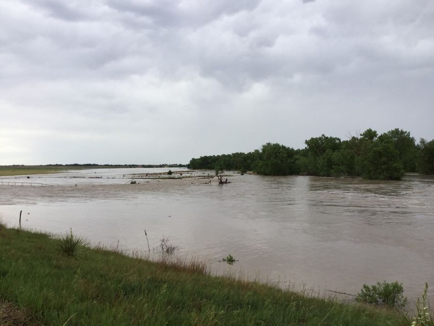
2018 Kansas Tornado Overview
Tornadoes:          45         17 below the 1950-2018 average of 62
                               50 below the past 30 year average of 95
                               48 below the past 10 year average of 93

Fatalities:         0          Injuries: 8
Longest track:                 15.78 miles (Saline to Ottawa, May 1, EF3)
Strongest:                     EF3 (Saline to Ottawa, May 1; Greenwood, June 26)
Most in a county:              9 (Cowley).
Tornado days:                  14 (Days with 1 or more tornadoes)
Most in one day:               9 (May 2, May 14)
Most in one month: 34 (May)
First tornado of the year: May 1 (Republic Co., 4:44 pm CST, EF0 5.29 mile length, 125 yard width)
Last tornado of the year: October 8 (Brown Co., 3:39pm CST, EF0, 3.12 mile length, 75 yard width)
Length of tornado season:                    160 days (Days between first and last tornado)

                         2018 Monthly Tornado Totals
  Month       Jan        Feb    Mar     Apr     May    Jun    Jul    Aug   Sep   Oct    Nov   Dec   Total
    EF5        0          0       0      0       0      0        0    0     0     0      0     0     0       0%
    EF4        0          0       0      0       0      0        0    0     0     0      0     0     0       0%
    EF3        0          0       0      0       1      1        0    0     0     0      0     0     2      4.4%
    EF2        0          0       0      0       1      0        0    0     0     0      0     0     1      2.2%
    EF1        0          0       0      0       5      0        0    0     0     0      0     0     5      11.1%
    EF0        0          0       0      0       27     4        2    3     0     1      0     0     37     82.2%
   Total       0          0       0      0       34     5        2    3     0     1      0     0     45     100%
   Per-
              0%         0%      0%     0%     75.6% 11.1% 4.4% 6.7%       0%    2.2%   0%    0%
   cent
           Violent (EF4—EF5) in red, Strong (EF2-EF3) in yellow, Weak (EF0-EF1) in green.
            Monthly totals in gray. (Percent values may not add to 100% due to rounding)

    Annual Highlights: A total of 45 tornadoes occurred in Kansas in 2018 which is below the
    long term average (records beginning in 1950). This is well below the 10 year and 30 year av-
    erage number of tornadoes. No violent tornadoes occurred in Kansas last year, and no tornado
    related fatalities were reported. On June 26th, an EF3 tornado tracked across 9.15 miles in
    Greenwood County resulting in eight injuries.
    May was the most active month of 2018 with 34 tornadoes. This is 93 tornadoes below the one
    month record of 127 tornadoes reported in May 2008.
    The costliest tornado of 2018 was the EF3 tornado that went through Greenwood County.
    Damage was estimated to be $13,690,000.

                                      KANSAS SEVERE WEATHER AWARENESS WEEK
                                                  MARCH 4-8, 2019
                                                             3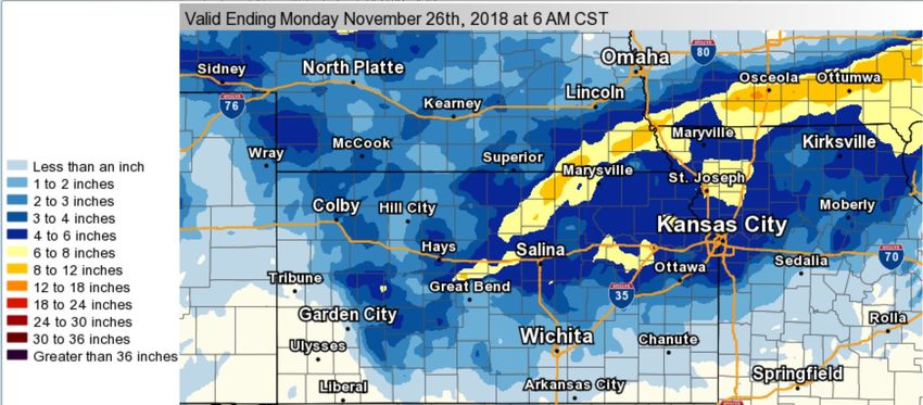
Kansas Tornado Statistics
                                           by County
                                      1950 - 2018
                          TORNADOES, FATALITIES, AND INJURIES

                          Legend: Tor = Tornado | Fat = Fatalities | Inj = Injuries
  County     Tor   Fat     Inj      County       Tor     Fat     Inj       County       Tor    Fat   Inj

   Allen     27     0      4      Greenwood       44       0      18        Pawnee      52      0     1
Anderson      15    3      12      Hamilton       30       0       1        Phillips    41      0     1
Atchison      15    0      11       Harper        62       0       1     Pottawatomie   34      1     5
 Barber       40    0       2       Harvey        49       1      63          Pratt      73     3     10
 Barton      102    2      40       Haskell       32       0      10
                                                                            Rawlins      47     0      4
Bourbon       19    0       7     Hodgeman        55       0       4
                                                                             Reno        81     0     22
 Brown        46    0       5      Jackson        31       4      17
 Butler       84   28     225                                              Republic      62     0      3
                                   Jefferson      41       0     101
 Chase        41    0       2                                                 Rice       47     0      6
                                    Jewell        43       0       2
                                                                             Riley       29     0     51
Chautauqua   20     0      0       Johnson        44       0      12
                                                                             Rooks       52     0      6
 Cherokee    37     4     66        Kearny        45       0       0
                                                                             Rush        52     0      8
                                   Kingman        67       0       1
Cheyenne     43     0      0                                                Russell      78     1      7
                                     Kiowa        59      11      74
   Clark     40     0       0                                                Saline      46     0     66
                                    Labette       42       1      29
   Clay      45     1      31                                                Scott       58     1      1
                                     Lane         47       0       2
  Cloud      52     1       8                                              Sedgwick      89    13    360
                                 Leavenworth      30       2      30
  Coffey     24     0       5                                               Seward       38     0     15
                                    Lincoln       33       0       2
Comanche     42     0       2                                              Shawnee       55    18    528
                                      Linn        14       0       3
  Cowley     82    77     293                                              Sheridan      41     0      0
                                    Logan         29       0       0
 Crawford    35     4      43                                              Sherman      110     0      0
                                     Lyon         48       7     222
 Decatur     47     0       5                                                Smith       45     0      2
                                    Marion        47       1       2
Dickinson    38     1      17                                               Stafford     72     3      5
                                   Marshall       34       0       1
 Doniphan     19    0      2                                                Stanton      22     0      0
                                  McPherson       55       1      16
 Douglas      40    1     48                                                Stevens      25     1      5
                                    Meade         51       0       0
 Edwards      50    0      7                                                Sumner       85     5     14
                                     Miami        20       4      10
     Elk      24    2      8                                                Thomas       46     0      1
                                    Mitchell      49       0       5
    Ellis     62    0      6                                                 Trego       63     5    101
                                 Montgomery       36       1       1
 Ellsworth    51    0      0                                              Wabaunsee      38     1     26
                                   Morris         34       0       7
   Finney     98    1     41                                                Wallace      35     0      4
                                   Morton         20       1       2
    Ford     101    0      2                                              Washington     40     2     12
  Franklin    30    3     34      Nemaha          37       0       3
                                                                            Wichita      35     0      4
   Geary      19    0      3       Neosho         31       0       4
                                                                            Wilson       16     0      0
    Gove      58    0      3        Ness          53       0       4
                                   Norton         30       0       0       Woodson      12      0     8
  Graham      42    0      0
   Grant      25    0      9       Osage          45      17       6       Wyandotte    10      2    36
    Gray      51    0      3      Osborne         45       0      13
                                   Ottawa         35       2      12          Total
 Greeley     39     0      0                                                            4699   237   2924

                         KANSAS SEVERE WEATHER AWARENESS WEEK
                                     MARCH 4-8, 2019
                                                   4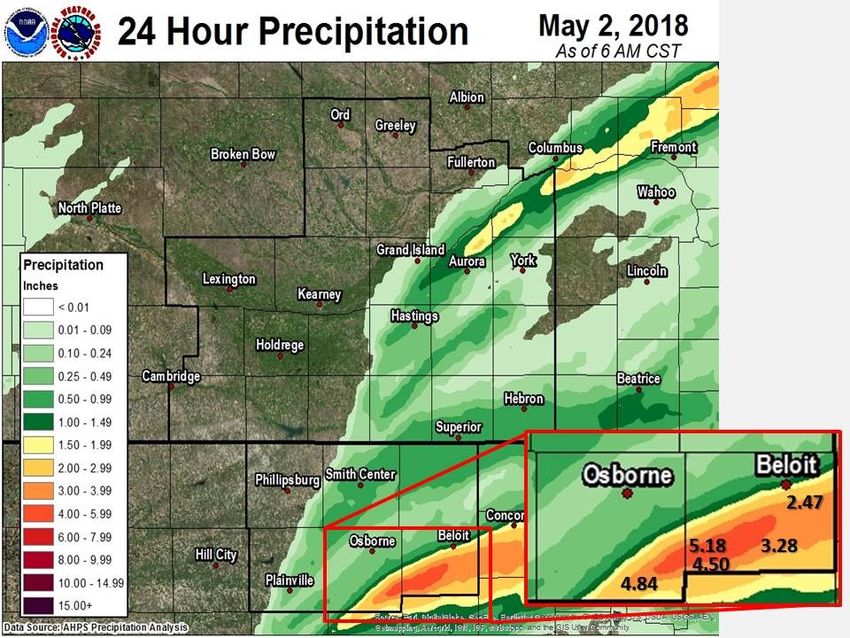
Kansas Tornadoes 2018

             Kansas Tornado Facts
Days with more than 20 tornadoes       Kansas Tornado Count by Decade
    Date        #Tornadoes                     1950s: 560
      05/23/08          70                     1960s: 457
      04/14/12          43                     1970s: 303
      06/15/92          39                     1980s: 339
      05/05/07          36                     1990s: 789
      05/24/16          34                     2000s: 1192
      06/04/55          33                     2010s: 679 (through 2018)
      05/29/04          28
      10/26/06          28
      05/25/97          25              Most Tornadoes in One Episode
      06/09/05          25             May 23, 2008        70 Tornadoes
      05/15/91          24             April 14, 2012      43 Tornadoes
      07/07/04          23             June 15-16, 1992    41 Tornadoes
     05/06/15            22
      04/26/91          21
      06/15/09          21

             KANSAS SEVERE WEATHER AWARENESS WEEK
                         MARCH 4-8, 2019
                                   5
Did you know...
There are seven National Weather Service offices that serve portions of Kansas!
National Weather Service (NWS) offices in Kansas are located in Goodland; Dodge City; Wichita;
Topeka; Hastings, Nebraska; Pleasant Hill (Kansas City), Missouri; and Springfield, Missouri. Each
office is staffed by a team of highly trained meteorologists, technicians, electronics technicians, infor-
mation technology specialists, hydrologists, and administrative assistants. The NWS offices are
staffed 24 hours a day, seven days a week, 365 days a year.
Contact the NWS office in your area to learn more about weather, weather safety, NOAA Weather
Radio, office tours, or to learn more about careers in meteorology in the NWS or in NOAA.
We are here to serve you!
The following pages contain 2018 severe weather summaries for each
NWS office. Here is severe weather terminology you may encounter.
Severe Thunderstorm – The National Weather Service issues severe thunderstorm warnings for
storms that are currently or are capable of producing winds of 58 mph or stronger and/or hail one
inch in diameter or larger. Severe thunderstorms are often much stronger than this minimum crite-
ria, so it is a good idea to take severe thunderstorm warnings seriously.
Tornado – A tornado is a violently rotating column of air in contact with the ground either as a
pendant from a cumuliform cloud or underneath a cumuliform cloud, and it is often (but not always)
visible as a funnel cloud. A funnel cloud is a condensation cloud typically funnel-shaped and ex-
tending outward from a cumuliform cloud and is associated with a rotating column of air.
Flash Flood – A flash flood is flooding that occurs very rapidly and usually within 6 hours of heavy
rainfall. Flash flooding may occur along creeks, rivers or streams. It can also occur in low lying or
urban areas where drainage is poor. Water levels can rise very quickly during flash flooding including
locations that did not receive the heavy rainfall but are located downstream from areas that received
an extreme amount of rainfall. Flash flooding can occur in the winter months when rain falls on ex-
isting snowpack and causes it to melt rapidly. Flooding is the number one severe weather killer in
the U.S.
KANSAS SEVERE WEATHER AWARENESS WEEK
MARCH 4-8, 2019
6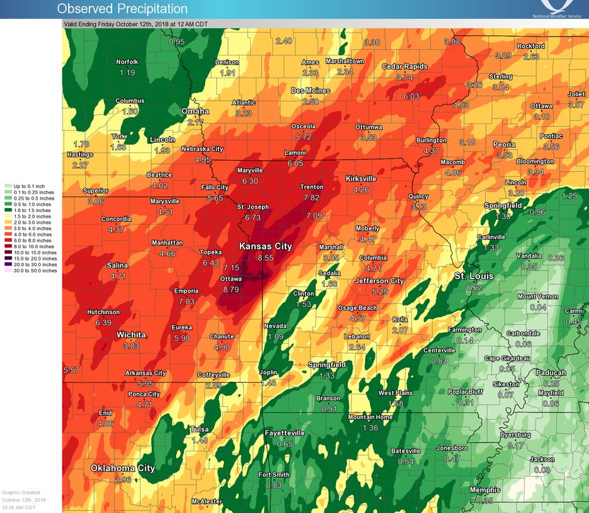
2018 Severe Weather Summary
Extreme East Central and Northeast Kansas
National Weather Service - Pleasant Hill, MO
While 2018 was generally pretty quiet across far northeast Kansas
from a severe weather standpoint, there were several notable events
2018 Far Northeast that impacted the region. The lone tornado to occur in the far north-
Kansas Severe Weather eastern seven Kansas counties occurred on May 2 when an EF-1 tor-
Stats nado produced a four to five mile stretch of damage in Overland Park,
By The Numbers KS. Extreme to exceptional drought impacted the agricultural commu-
nity through the summer months after an incredibly dry late spring and
summer. The drought was broken by an increase in rainfall through the
Number of Severe Wind, late summer and ultimately a mid-autumn extreme rainfall event. On
Hail, Flooding Reports: October 6-9, most of northeast Kansas received between six and ten
63 (2017: 163) inches of rain. These rains produced scattered flooding which caused
a fatality in Miami County.
Tornado: 1 (EF-1) May 2, May 2, 2018 - Strong
2018 Storms and Weak
Tornado in Johnson
County
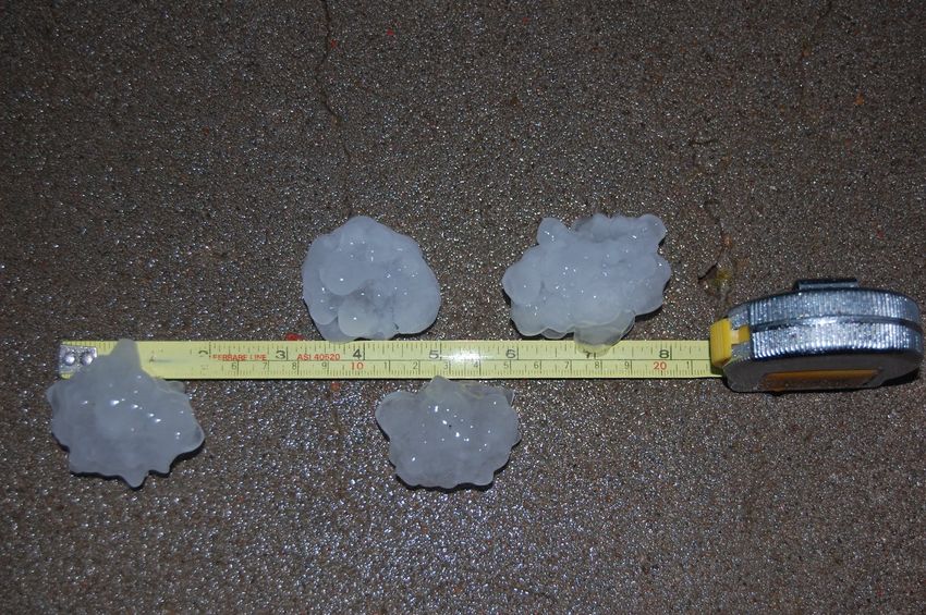
Largest Hail: On the evening of May
2.00” (Johnson County) 2, 2018 a line of strong
April 13, 2018 storms moved through
eastern Kansas. While
strong storms occurred
Strongest Wind: 82 mph across the entire east-
(Linn County) May 2, 2018 ern part of the state, The tornado on May 2, 2018 formed near
(measured) the strongest impacts 143rd and Antioch doing damage to trees in
were felt within the residential neighborhoods in that area. The
Kansas City Metro ar- tornado then did damage to Overland Trail
Most reports received: Middle School blowing out over 20 windows
ea. An EF-1 tornado
Johnson County (28) at Mission and 133rd. There were several
formed in Overland power poles down, and the tornado likely dis-
Park causing a fair sipated near the Kansas Missouri state line
amount of damage in near 130th Street.
the form of widespread
tree damage and some structure damage to local schools; numerous
power lines and power poles were destroyed. The line of storms con-
tinued into western Missouri where they went on to produce more tor-
nadoes and scattered wind damage.
Exceptional Drought June through October
Starting at the very end of May and going into June, the U.S. Drought
KANSAS SEVERE WEATHER AWARENESS WEEK
MARCH 4-8, 2019
7
Monitor at the University of Nebraska declared portions of eastern
                                     Kansas in a severe (D2; see left image) or worse drought. The
                                     anomalously dry period that plagued the region during the summer
                                     of 2018 continued into and through July, with most areas coming
                                     up about two inches short of normal precipitation for the month.
                                     Precipitation picked up during August especially in some of the
                                     hardest hit drought areas, but in a lot of cases the damage had al-
                                     ready been done. While the rains did pick back up, the ground soil
                                     was so parched that it made hardly a dent in the drought across
                                     northeast Kansas. Much of the area saw some relief from the
                                     drought; however, many counties remained in severe to exception-
                                     al (D2-D4) status through the month of September. While the full
UNL Drought Monitor for North-       scope of drought impacts are unknown, many farmers took losses
east Kansas at the height of the     on their hay and corn opting to bale it for livestock or knock it
2018 drought showed widespread       down. Things changed in October when widespread heavy rain
D4 (Exceptional Drought) for         ended that drought. Widespread six to nine inches of rain fell with
much of the region.
                                     some locations receiving over a foot of rain over the four day
                                     stretch from October 6 through October 9.
October 6-9 Heavy Rain With 6-10 Inches in the KC Metro
On the 6th of October a cold front pushed into the area and stalled in southern Missouri and Kansas.
Moisture continued to stream into the area bringing several rounds of moderate to heavy rain. The
heaviest rain occurred Saturday and Sunday (October
6-7). By Tuesday night (October 9th) more than 11
inches of rain fell in and around the Kansas City Metro.
Local drought conditions were still in the “Extreme” to
“Exceptional” category going into the event, so flash
flooding was relatively low impact and relegated mostly
to several road closures. The bigger impact from this                         6-10”
prolonged rainfall event came from local river and
stream flooding. Several streams entered the moderate Kansas City
to major flooding category. The only known fatality
from these heavy rains occurred in Miami County when
a lady, who was missing for several days, was found in
her car when the flood waters subsided.
The four day event spanning Oct 6-9 resulted in the
greatest four day rain total in recorded Kansas City his-
tory. At Kansas City International Airport, just across
the river from northeast Kansas, 9.79 inches were rec-
orded for the Oct 6-9 time period. The 9.79" contributed    Observed precipitation between Oct 6 and
                                                            Oct 9 totaled between 6 and 10 inches of rain
to an October precipitation total reaching 10.76" which
                                                            across NE Kansas which effectively ended
put October 2018 as the second wettest October in
                                                            the ongoing extreme drought conditions.
Kansas City history behind October 1941 (11.94").

                          KANSAS SEVERE WEATHER AWARENESS WEEK
                                      MARCH 4-8, 2019
                                                    8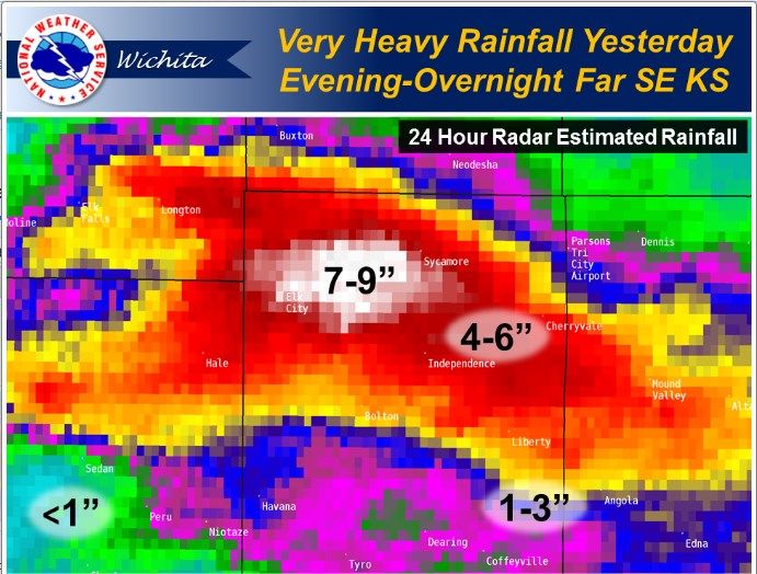
2018 Severe Weather Summary
                                Northeast and East Central Kansas
                               National Weather Service - Topeka, KS
                        The weather events in 2018 that had the most impact across northeast
                        Kansas     included     the    destructive  flash  flooding    around
2018 Northeast and East Manhattan   over Labor  Day,  and damaging thunderstorm winds  not as-
                        sociated with tornadoes on July 19th. The year will also be remem-
 Central Kansas Severe bered for the first November blizzard in recorded history to strike the
     Weather Stats      northeast portion of the state on November 25th.
    By The Numbers           May 1st Strong Tornado in Ottawa County
Number of Severe Wind,                                                       A strong tornado de-
Hail, Flooding Reports:                                                      veloped in northwest-
353 (2017: 309)                                                              ern Saline County and
                                                                             moved into Ottawa
                                                                             County doing damage
Tornadoes: 15; Strong-                                                       to several structures
est (EF-3) Ottawa Co.,                                                       including a single fam-
 May 1, 2018                                                                 ily home. The tornado
                                                                             was well documented
                                                                             by many chasers and
Largest Hail:                                                                became a wide torna-
4.00” (Ottawa County)        do with multiple vortices. Thankfully the tornado tracked through pri-
May 1, 2018                  marily rural areas so damage was limited and the tornado dissipated
(estimated)                  several miles southwest of the city of Minneapolis Kansas. The torna-
                             do was rated as an EF3.

Strongest Wind: 89 mph July 19th Damaging Thunderstorm Winds
(Douglas County)       A cluster of thunderstorms developed across north central Kansas late
July 19, 2018
 (measured)

Most reports
received:
Shawnee County
(34)

                                                        Storm Reports July 19th.
                                                        w=60-80 mph W>80mph

                        KANSAS SEVERE WEATHER AWARENESS WEEK
                                    MARCH 4-8, 2019
                                               9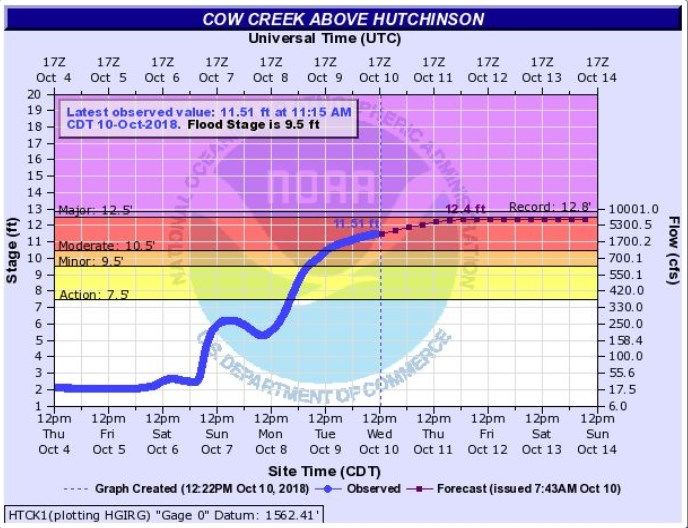
in the morning on July 19th. This cluster of storms began to form into a line then accelerate south-
east and within just a few hours caused millions of dollars in damage across the area due to wide-
spread 60-90 mph winds. The winds knocked out power to over 30,000 customers many of those in
the Topeka area. Some of the worst damage was reported around the city of Topeka (images be-
low) where numerous businesses sustained structural damage, and widespread tree damage was
reported between 3 and 4 pm. As is often the case in Kansas, the widespread damage was not
caused by a tornado but by strong straight line winds associated with a line of storms.
Sept 3rd Manhattan Wildcat Creek Flooding

Thunderstorms were nearly constant across the area just northwest
of Manhattan during the overnight hours of Sept. 3rd. By sunrise
many areas just northwest of the city had received five to ten inches
of rain and much of that fell into the small area that fed into the infa-
mous Wildcat Creek. In less than three hours, the creek in western
parts of the city went from docile to destructive with flash flooding of
many areas in the vicinity of the creek.
According to the city manager, the flooding caused over 17 million
dollars in structural damages in the city. Over 300 people were
forced to evacuate their homes due to the flooding with around 20
evacuated by boat. It is believed that the crest was a record around
28 feet at the Scenic Drive gage on Wildcat Creek from this flash
flood event.
November 25th Blizzard
For the first time since records began over 100 years ago, a blizzard
struck northeast Kansas in November with winds of 40-50 mph and
heavy snow that closed Interstate 70 from To-
peka west for a time as well as snarling traffic
on the Kansas Turnpike and I-35. The snow
began to fall around sunrise and ended by
sundown; however, in that time many areas

                         KANSAS SEVERE WEATHER AWARENESS WEEK
                                     MARCH 4-8, 2019
                                                  10
received 4 to as much as 12 inches
of snow. Thunder snow was reported
in some areas including Topeka at
the height of the storm in the early
afternoon. Many areas had near ze-
ro visibilities due to the heavy falling
snow and blowing snow. The heavy
snow impacts were felt for days af-
terwards with many schools closed
for a day or two after the storm had
ended.
Check out a storm spotter and weather safety training
presentation near you this spring!
Each spring, the National Weather Service offices that serve the state of Kansas conduct storm
spotter and weather safety training sessions in most counties in the state. The sessions are free
and open to the public. You are not required to become a storm spotter nor will you have to take
a test; however, the presentations provide a great deal of information on severe weather in Kan-
sas. They cover severe weather safety and ways to get weather information from the National
Weather Service. You can also meet a meteorologist from your local National Weather Service
office.
The schedule for storm spotter training sessions varies in each community, please check out
www.weather.gov and click on your location for more information on a training session in your
area.
KANSAS SEVERE WEATHER AWARENESS WEEK
MARCH 4-8, 2019
112018 Severe Weather Summary
Central, South Central & Southeast Kansas
National Weather Service - Wichita, KS
Overall, 2018 was a rather quiet year in regards to significant weath-
2018 Central, er. One exception would be the tornado that moved across Eureka,
South Central and KS. This storm carved a path northeast across the community;
Southeast Kansas Through a part of town that had been hit by an EF-2 tornado only
Severe Weather Stats two years prior. Significant flooding also occurred later in the fall
By The Numbers with several rivers and creeks reaching well into moderate flooding.
Unfortunately, two people lost their lives after driving into an area
where a creek had reached levels up to 4 foot deep with rapidly flow-
Number of Severe Wind, ing water moving over the roadway.
Hail, Flooding Reports:
January 11th Snow and Wind Event
297 (2017: 406)
A very early first snow of the winter season came in 2018 when
much central and
Tornadoes: 20 (Average northeast Kansas
19); Strongest (EF-3) picked up between
Greenwood Co., June 26, three and six inch-
2018 es of snow. For
much of the area it
was the snowiest
Largest Hail: start to a winter
4.00” (Barton County) May season since
1, 2018 1951. This winter
event also caused
difficult travel con-
Strongest Wind: 87 mph ditions with the
(Rice transitional freez-
County) ing rain/sleet/snow
July 29, mixture. To further complicate the event,
2018 the winds gusted at speeds over 45 mph
measured) at many locations. In total, over 150 ac-
cidents were reported.
Most May 1st Tescott Tornado
reports After one of the slowest starts to a torna-
received: do season on record for both Kansas &
Cowley Oklahoma, May started off strong. Se-
County & vere storms affected central & northeast
Sedgwick Kansas on May 1st. The most significant
county (34) tornado developed in extreme northern
KANSAS SEVERE WEATHER AWARENESS WEEK
MARCH 4-8, 2019
12Saline County and tracked north into Ottawa County. This large tornado became known as the Tes-
cott tornado. Several reports of large hail were also noted as the storms tracked across the area.
May 14th Maple City Tornadoes
On May 14th a supercell thunderstorm tracked across Sumner County. It produced several brief tor-
nadoes with the most intense producing EF-2 damage near Maple City. The most unique aspect of
this storm is that after crossing into Oklahoma, it turned back to the north and produced another tor-
nado in Cowley County.
Winfield
Maple City
Arkansas City
June 26th Eureka Tornado
Shortly after 7 pm on June 26th, the most destructive tornado to affect the area in 2018 struck the
community of Eureka, Kansas. The tornado first touched down just southwest of town and caused
considerable damage as it tracked northeast through Eureka. As it moved into town, most of the ini-
tial damage was to tree tops and roofs. However, as it continued to move to the northeast, it intensi-
fied significantly in the middle portions of town causing more widespread and significant damage.
The tornado continued to track northeast and hit the high school producing major damage to the
KANSAS SEVERE WEATHER AWARENESS WEEK
MARCH 4-8, 2019
13football field and gymnasium before moving out
into open country causing sporadic damage.
This tornado was given an EF-3 rating and was
the second tornado to strike the town in the last
3 years.
August 14th Flash Flooding
Slow moving storms dumped copious amounts
of rain across northern Montgomery County on
August 14th. Between seven to nine inches of
rain were reported with most of this falling in on- Independ-
ly a few hours. The total reported in Independ-
ence was 8.37 inches. Unfortunately this
caused flash flooding along Racket Creek about
one mile north of Elk City Lake; a vehicle was
swept off of the road killing two individuals. The flooding occurred during the late evening hours and
continued through the night.
Early October Flooding
The most widespread flooding event of 2018 took place during a five day stretch in October. From
October 5th to the 9th, much of south central & southeast KS picked up between seven and ten
inches of rain which caused widespread river flooding. At one point, NWS Wichita had river flood
warnings for 35 river forecast points along with 20 additional areal flood warnings.
November 25th Blizzard
On November 25th, 50 to 60 mph winds combined with
three to six inches of snow producing blizzard conditions
across much of the area. Reduced visibility caused large
stretches of I-70 to be shut down. The strong winds were
also responsible for minor property damage across the
area.
KANSAS SEVERE WEATHER AWARENESS WEEK
MARCH 4-8, 2019
142018 Severe Weather Summary
North Central Kansas
National Weather Service - Hastings, NE
It was a relatively quiet year for Severe Weather across north central
Kansas. Some notable events included one tornado in rural Mitchell
2018 North Central County and some large damaging wind and hail across Mitchell and
Kansas Severe Weather
Osborne counties. Additionally warm season rainfall helped elimi-
Stats
nate drought conditions by the end of Summer.
By The Numbers
Typically severe weather emerges across north central Kansas in
March, and 2018 was no different. In the midst of a chilly spring,
Number of Severe Wind, March 23rd brought a combination of 60+ mph winds and quarter to
Hail, Flooding Reports: ping-pong ball sized hail to Smith and Phillips counties.
353 (2017: 309) It would be over a month until severe weather returned and brought
the only reported tornado in 2018 to this area. On May 1st, an EF-0
rated tornado was seen in open country in southern Mitchell County
Tornado: 1; Strongest and lasted only a short time. The area also experienced large hail,
(EF-0) Mitchell Co., high winds and flooding. Reported storm damage was generally con-
May 1, 2018 fined to Osborne County with minor damage reported to outbuildings
and farm machinery. As much as six inches of rain fell resulting in
flooding in Mitchell and Osborne counties.
Largest Hail:
The final week of May was active across the area including more
2.50” (Osborne County)
heavy rain. May 28th-29th was the most active with three to five inch-
September 1, 2018
es of rain followed by 60+ mph winds and hail causing localized dam-
age to the wheat crop. Rainfall up to 10 inches upstream in Graham
County resulted in flooding on the South Fork of the Solomon River
Strongest and the Bow
Wind: 68 Creek; addition-
mph (Jewell ally a significant
County) amount of water
September 1, was deposited
2018 into Webster and
(measured) Kirwin Reser-
voirs.
Most reports The summer
received: months brought
Phillips more rainfall to
County (20) the area and
sporadic reports
of hail and strong
winds. One nota-
ble event was on
KANSAS SEVERE WEATHER AWARENESS WEEK
MARCH 4-8, 2019
15June 9th around 4:45 AM when
isolated wind damage occurred in
the Beloit area including some
power poles and roof damage in
town. The airport wind sensor re-
ported a 44 mph wind gust, but
winds in town were estimated over
60 mph. On June 19th-20th, an-
other round of heavy rain cause
some minor flooding on the White
Rock Creek east of Burr Oak.
Nearly five inches of rain fell in the
area.
Baseball size hail measured by Mike Jordan southwest of Beloit
on May 1st.
July followed June with only a handful of severe weather reports after which August recorded no se-
vere weather. The next round of severe weather was on September 1st when high winds and hail
rolled across Osborne, Jewell and Mitchell counties. A measured wind gust of 66 mph was reported
west of Beloit while a 78 mph wind gust was measured in Jewell. Spotty damage was reported in the
Lovewell State Park area.
Though the severe weather events of 2018 may not last long in one’s memory, rainfall during the
warm season did provide beneficial drought relief to north central Kansas. Entering the season,
north central Kansas was considered abnormally dry or in moderate drought (D1) while a large part
of southern Kansas was considered in extreme drought (D3) or worse. Going into the fall, a majority
of the state was considered drought free with only the northern Flint Hills and northeast Kansas con-
sidered to be experiencing drought condi-
tions.
End of Summer Drought Conditions
Courtesy of U.S. Drought Monitor
KANSAS SEVERE WEATHER AWARENESS WEEK
MARCH 4-8, 2019
162018 Severe Weather Summary
Southwest Kansas
National Weather Service - Dodge City, KS
Southwest Kansas experienced many weather extremes throughout
2018. The year started with severe to extreme drought conditions
2018 Southwest Kansas which were quickly erased as very wet weather developed. Several
Severe Weather Stats flooding events occurred throughout the spring, summer and fall. In
By The Numbers addition, temperatures were highly variable with several extreme
events observed.
Number of Severe Wind, Although monthly average winds were above normal only three times
Hail, Flooding Reports: this year, there were many high wind events associated with cold
509 (2017: 527) fronts, thunderstorms, and strong low pressure systems. In fact,
Dodge City had a record number of days with wind gusts over 50
mph in 2018!
Tornadoes: 6; Strongest The following are the highlights for the year.
(EF-0) Average: 28
Temperature Extremes
Frigid Arctic air invaded Kansas in late December 2017 but persisted
Largest Hail: 4.00” (Ford through January 2nd. In Dodge City, the lowest temperature of 2018
County) May 29, 2018 was 9 below zero on New Year’s Day which was the coldest temper-
ature observed since December 18, 2016. There were four days, all
in January, with minimum temperatures of zero or below.
Strongest Wind: 87 mph April featured extreme daily and hourly temperature variability (Fig
(Stanton County) 1). On April 17th alone, the temperature rose from 28 to 94 degrees
July 29, 2018 in a period of about 10 hours between sunrise and mid-afternoon at
(measured)
Dodge City. This 66 degree temperature swing inside of one calen-
dar day was only exceed-
Most
ed by a 67 degree swing
reports
on February 8, 1909 when
received:
the low and high were 2
Ford County
and 69 degrees respec-
(59)
tively.
May was the warmest on
record dating back to
1875 with an average
high of 87 at Dodge City
which was 11 degrees
above average. The only
Fig 1. April had extreme swings in May months that even
temperatures came close to May 2018
KANSAS SEVERE WEATHER AWARENESS WEEK
MARCH 4-8, 2019
17in terms of maximum temperature were May 1962 and May 2012 when the averages were 84.9 and
85.2 degrees respectively.
The warmest reading of the year at Dodge City was 104 degrees which occurred on June 10th.
Highs reached 100 degrees (or more) on six days in June. However, temperatures averaged below
climatology for most of the summer and reached 100 degrees on only two days in July and one day
in August. October and November were colder than normal.
The first major intrusion of cool fall air was on September 28 th when the high was only 56; and the
final occurrence of 90+ degree readings was on October 3rd when the temperature reached 96.
The first freeze in Dodge City occurred on October 14 th with a low of 29 and was accompanied by a
half inch of snow. The coldest air of the fall season arrived on December 28 th with a low of 12 de-
grees and a high of 25.
Record Wind
Even though the monthly average wind at Dodge City was above normal only 3 times (February,
April and June), wind gusts reached 50 mph during each month in 2018! In addition, wind gusts
reached or exceeded 50 mph on 39 separate days in 2018. This was more than had been observed
for any year for which reliable records were available. Only two other years had 20(+) days of 50
mph wind gusts, the highest was 2008 having 26 separate days. High thunderstorm winds occurred
several times over the summer. However, high winds also accompanied two snow events in Novem-
ber and December with wind gusts as high as 70 mph.
2018 Precipitation
In general, precipita-
tion was above the cli-
matological average
for southwestern Kan-
sas with 27.97 inches
reported at Dodge City
(Fig 2), but much of
this occurred in the
second half of the
year. In fact, 43%
(12.02 inches) of the
total fell on six calen-
Fig 2. Cycles of wet and dry periods with the past five years generally wet dar days with the re-
mainder falling on 73 calendar days. The normal yearly amount at Dodge City is 21.60”. Other loca-
tions across western and south central Kansas had much more precipitation. A location 6 miles
west/southwest of Pratt recorded 46.82 inches, and in the Hays area there was around 41 inches for
the year! These are incredible totals considering how dry the year started!
January through February was one of the driest on record. Total precipitation for January and Feb-
ruary combined at Dodge City was only 0.15 inches. March did have a few precipitation events. But
from January through March, Dodge City only recorded 1.21 inches of precipitation. Central and
KANSAS SEVERE WEATHER AWARENESS WEEK
MARCH 4-8, 2019
18western Kansas received 25
to 50% of their climatological
average rainfall for this three
month period (Fig 3). The
spigot was finally opened lat-
er in the spring and sum-
mer. Precipitation totals were
well above average in the Ju-
ly-October period, and the
total rainfall at Dodge City for
that four-month period was
the third highest on record
back to 1874. A total of 6.68
inches of rain fell in Dodge
City in August including 3.84
inches overnight on 18-19
August. This was the fifth
Fig 3. Precipitation percent of normal from
January 1 through March 31 wettest August on record. Oc-
tober also was extremely wet
with 6.45 inches of rain breaking the old record of 5.0 inches established in 2008. None of southwest
Kansas was in a drought category on the U.S Drought Monitor by 2 October although the year start-
ed with a sizable area of southwest Kansas in extreme drought.
Seasonal Snowfall
Total snowfall in Dodge City for the 2017-2018 season was only 3.6 inches (Fig 4) which was much
below the long term average of approximately 21 inches and the 3rd lowest total on record! For
many locations across western Kan-
sas there was below normal snowfall.
Extreme Fire Weather Event
The high winds and dry weather the
first part of the year provided a favor-
able environment for wildfires, but
Kansas largely was spared from huge
fires such as occurred in 2016 and
2017.
One of the most extreme days for fire
Fig 4. Seasonal snowfall that has occurred at Dodge City. weather was April 17th. The tempera-
ture fell to 28 degrees around sunrise
but recovered to 94 behind a dry line in the afternoon with southwest winds gusting to near 50 mph
and relative humidity values as low as 6%. A cold front moved through western Kansas in the even-
ing followed by north winds gusting in excess of 60 mph, and local visibilities dropped to near zero
due to blowing dust. A prairie fire (Fig 5) began in eastern Colorado in the afternoon and spread rap-
KANSAS SEVERE WEATHER AWARENESS WEEK
MARCH 4-8, 2019
19idly into Stanton and northern Morton counties in the
evening. Nearly 50,000 acres and a number of struc-
tures were burned.
Severe Thunderstorm Events
There were only six tornado reports in southwest
Kansas in 2018, and most of these were weak. The
climatological average is 28 tornadoes. In this part of
the state, the first tornado of the year was on May
18th, and the last tornado was on July 13th. The most
prominent tornado occurred near Ensign on May 29 th
Fig 5. Wildfire moving into Stanton and which was visible from the NWS office in Dodge City
Morton counties on April 17, 2018.
located about 15 miles away (Fig 6). The tornado
developed northwest of Ensign in Gray County and moved east-northeast dissipating just inside
Ford County (Fig 7). The tornado managed to miss structures that could have been damaged.
Scouring of muddy fields was observed to be eight inches deep in spots.
May 29, 2018 Tornado Track
Fig 6. May 29 tornado as observed from Dodge City Fig 7. Track of the May 29 tornado
Several episodes of very large hail occurred across western Kansas in 2018. On May 17th, the most
notable storm developed in Colorado and moved across Scott, Lane, Ness, Hodgeman and north-
eastern Ford counties. Winds up to 80 mph and hail as large as baseballs tore off siding and dented
cars. Crops across parts of
Scott County were destroyed.
Most of the houses in Dighton
suffered broken windows and
roof damage. This storm left a
Fig 4. Seasonal snowfall that has occurred at Dodge City. hail swath 10 to 15 miles wide
(Fig 8).
There were three consecutive
days from June 22 to June 24
where severe wind gusts were
Fig 8. Path of the hail on 14 May and locations of reports (green H)
KANSAS SEVERE WEATHER AWARENESS WEEK
MARCH 4-8, 2019
20observed at the NWS office in Dodge City (80,
70 and 59 mph wind gusts respectively) as lines
of storms moved eastward and southeastward
each day across western Kansas. The photo
(Fig 9) shows the leading edge of the storm line
on 22 June.
Extreme Rainfall Events
A total of 6.68 inches of rain fell in Dodge City in
August (Fig 10) including 3.84 inches overnight
on August 18th-19th when a weak tropical upper
level trough rotated around an anticyclone in
Texas and approached the Central Plains. Up to
5 inches of rain fell in less than four hours on
the northwestern edge of Dodge City where
Fig 9. The dramatic leading edge of a storm that
produced straight-line winds on June 22.
there were reports of basement flooding.
Another rainfall event occurred on Septem-
ber 3rd when six to eight inches of rain fell in
a large area in south central Kansas pro-
ducing devastating flooding on the Ninnes-
cah River in Pratt County (Fig11). Some of
the worst damage was done at the Pratt
Fish Hatchery operated by the Kansas De-
partment of Wildlife and Parks. The Ninnes-
cah overtopped dams of around 87 ponds
used to rear fish to stock many lakes in
Kansas, and all of the young fish and the
breeding stock were washed downstream.
A rainfall amount of 8.47 inches was report-
ed in the south part of Pratt (Fig 12). Fig 10. 24 hour rainfall amounts ending at
6 AM August 19, 2018
Fig 11. Severe flooding in Pratt. Fig 12. Radar estimated rainfall for Sept 3rd.
KANSAS SEVERE WEATHER AWARENESS WEEK
MARCH 4-8, 2019
21Extreme Winter Weather
Blizzard to near blizzard conditions
occurred on 25 November, but the
most notable blizzard event of the
year occurred on December 27th. The
highest reported snow amounts were
west of a line from Liberal to Wakeen-
ey which can be seen on visible satel-
lite imagery (Fig 13) from December
29th. The largest amount that was
reported to NWS Dodge City was 12”
in Richfield. Johnson City, Garden
City and Scott City received 10”, 6”,
and 8” respectively. It is likely based
on the lingering snow cover in the visi-
Fig 13. Satellite image showing snow cover. ble satellite imagery for 8 January (12
days after the event) that higher
amounts (10 to 12 inches or more) occurred in southwestern Grant, eastern Stanton, extreme north-
western Stevens as well as central and northern Scott counties. Snowfall was very difficult if not im-
possible to measure with a high degree of accuracy due to the horizontal fall of the snow and drift-
ing. Winds reached over 60 mph in some places causing considerable drifting and whiteout condi-
tions. While slowly shrinking day by day, the snow cover affected temperatures for two weeks with
much cooler readings across the snow packed areas.
2018 Severe Weather Summary
Southeast Kansas
National Weather Service - Springfield, MO
2018 Southeast Kansas Severe Hazardous weather across Bourbon, Crawford and Cherokee
Weather Stats counties was extremely minimal in 2018.
By The Numbers
Number of Severe Wind, Hail,
Flooding Reports: 34 (2017: 65)
While no tornadoes were reported, there were a limited number
of severe storms which produced marginal severe winds and
Tornadoes: 0 hail. The most notable was hail to the size of tennis balls near
Uniontown on June 26th. Another storm producing hail to the
Largest Hail: 2.00” (Bourbon County)
June 26, 2018 size of golf balls in Girard on May 19th.
Strongest Wind: 69 mph (Cherokee
County) Even flooding, which is normally more common, was limited to
July 12, 2018
(estimated) minor events in which several roads were impassible during the
last two weeks in August. No damages were reported.
Most reports
received: Bourbon & Cherokee (12)
KANSAS SEVERE WEATHER AWARENESS WEEK
MARCH 4-8, 2019
222018 Severe Weather Summary
Northwest Kansas
National Weather Service - Goodland, KS
Northwest Kansas experienced a relatively quiet severe weather
season when it came to tornado activity. Only three tornadoes were
2018 Northwest Kansas reported in 2018 which is the lowest tornado count since 2012 (two
Severe Weather Stats tornadoes) and the second lowest amount since 1989. Weather re-
By The Numbers lated damage and disruptions were mainly due to wind, hail, flooding
and winter weather.
Number of Severe Wind, Damaging Winter Weather Events
Hail, Flooding Reports: The first significant winter weather
279 (2017: 252) event of 2018 occurred January 21st
and 22nd bringing ice and snow to
northwest Kansas. Freezing drizzle
Tornadoes: 3; Strongest began on the morning of January 21st
(EF-0) and continued through the mid-
afternoon when it transitioned over to
snow. Snow continued through the
Largest Hail: afternoon, evening and overnight
3.25” (Logan County) hours before pushing east out of the
June 19, 2018 area on the morning of January 22nd.
Snow drifts west of Colby.
Total ice accumulations of a trace to
Image Courtesy: Dustin &
Strongest Brittany Kibel
Wind: 110
mph (Sherman thirty-eight hundredths of an
County) inch were reported in the Tri-
July 26, 2018 State region. Higher ice accu-
(estimated) mulations were reported in
Cheyenne County at one quarter
Most of an inch to thirty-eight hun-
reports dredths of an inch.
received: A moderate to heavy band of
Sherman snow developed in eastern Col-
County (48) orado on the morning of the 21st
and moved east into Kansas by
mid-afternoon. The first band
gradually ended overnight. A
second band developed and
moved east. Wind gusts typically
Observed 24 hour snowfall January 21st.
Image Courtesy: NOAA
ranged from 20-40 mph with
KANSAS SEVERE WEATHER AWARENESS WEEK
MARCH 4-8, 2019
23some higher gusts reported. Strong winds combined with
moderate to heavy snowfall and near zero visibility result-
ed in blizzard-like conditions across several counties in
northwest Kansas.
Hazardous road conditions in Logan County prompted the
closure of Highway 40 and Highway 83. At least one mo-
torist was stranded on Highway 40, and several motorists
were stranded in Oakley. A semi was reported to be
blocking Highway 83. The strong winds and snow result-
ed in power outages for approximately 400 people in Lo-
gan County.
Storm total snowfall amounted to around 11 inches of
Dust storm in downtown Goodland on snow in Rawlins and Cheyenne counties and 13 inches in
4/17. Image Courtesy: Mike Hopper northwest Sherman County. Snow amounts decreased
further east with six inches reported in Thomas County.
Severe Weather
The first severe hail report occurred on March 23 rd in Decatur County where quarter sized hail was
reported just west of Norcatur. A line of severe storms moved through Decatur, Norton and Gra-
ham counties producing large hail and strong wind gusts. The largest hail reported from this storm
was in Norton, Kansas where golf ball sized hail occurred.
Summer convective weather can cause injuries and damage; however, they are not the only weath-
er events that can cause destruction. On April 17 th, a dust storm caused several accidents and in-
juries. A strong cold front moving through northwest Kansas brought wind gusts of 60 to 80 miles
per hour to the area. Widespread blowing dust resulted in visibility less than one quarter of a mile
in Cheyenne, Sherman, Gove and Rawlins counties and near zero visibility in Logan, Wallace and
Wichita counties.
A two vehicle accident was reported on I-70 near Grainfield in Gove County due to blowing dust.
Several accounts of near zero visibility were reported across Thomas County. Five people were
injured in a three vehicle accident that occurred on
Highway 24 in Thomas County.
Strong winds brought down power lines in Wallace
County which sparked a wildfire north of the town of
Weskan. The fire grew to approximately three quar-
ters of a mile wide at times and traveled southeast
seven miles. Fire departments from neighboring
counties were called to assist with the fire; however,
widespread, near zero visibility made it difficult for
firefighters to respond. Numerous power poles and
two structures were lost as a result of the fire. Rail-
road and railroad bridge damage was also noted by a Wildfire aftermath near Weskan-4/17.
NWS employee a few days after the fire. Image Courtesy: Brandon Vincent
KANSAS SEVERE WEATHER AWARENESS WEEK
MARCH 4-8, 2019
24May started out slow in terms of severe weather with a dust storm reported in Logan County early in
the month. The second half of the month was more active beginning with a large hail event in Lo-
gan, Wallace, and Wichita counties on May 14th. A supercell with a history of producing significant
hail in Colorado crossed into Kansas. As the storm moved to the southeast, hail sizes continued to
grow reaching tea cup size at Weskan. Baseball sized hail in Logan County resulted in broken win-
dows on a vehicle and a house as well as damage to siding on a house. Broken windows and a
depth of two inches of hail were reported in Wallace County.
The first severe weather outbreak of May occurred on May 18 th. Scattered strong to severe thun-
derstorms formed during the late afternoon and evening hours over northwest Kansas with the
strongest storms near an old outflow boundary.
Several rounds of heavy rain moving through Rawlins and Gove counties resulted in flash flooding.
Numerous streets were reported to be underwater in Quinter. Eight to ten inches of water covered
the bottom of the ramp off of I-70 at exit 107. The fire de-
partment reported that a building in Herndon had water
flowing through it with a depth of four inches.
During the development of a thunderstorm, a weak EF0
tornado formed south of Tasco in Sheridan County. This
was the first tornado of the year for northwest Kansas. No
damage was reported as a result of the tornado. This
storm later went on to produce baseball sized hail in Gove
County near Quinter.
Rawlins County also received baseball sized hail and had
estimated wind gusts of 70 mph which broke three to four
inch diameter tree limbs. This was in the same area
Golf ball sized hail near Oberlin-5/18
Image Courtesy: Nathan Jurgensen where the baseball sized hail was reported. Severe hail
ranging in size from quarters to golf balls was reported in
Decatur, Thomas and Logan counties.
The largest severe weather event occurred on May 28 th. Storms kicked off in the morning and
spread west across northwest Kansas. Heavy rain began in Gove and Graham counties in the
morning and continued until late evening. One foot of water was reported near Highway 283 in
Graham County, and over one foot of water from Plum Creek was observed running over the C.R.
Castle Rock in Gove County.
Deep flood waters in Graham County resulted in water rescues at a trailer park next to Highway
283. Highway 283 was closed from Hill City to WaKeeney due to flood waters over the road. High-
way 18 from Bogue to Damar was also closed due to flooding. Four farmhouses were flooded and
20 cattle drowned where the Sand Creek and the South Fork of the Solomon River meet.
A tornado was reported in Graham County near Hill City. No damage was reported. Golf ball sized
hail was reported in several counties. Strong winds in Thomas County blew down large tree limbs
and power lines. Straight-line winds destroyed an empty grain bin and tore off part of a barn roof.
A second barn collapsed due to the winds; however, the structural integrity of the barn prior to its
collapse is unknown.
KANSAS SEVERE WEATHER AWARENESS WEEK
MARCH 4-8, 2019
25Storm activity picked up in June with multiple severe
weather events. Two rounds of thunderstorms moved into
northwestern Kansas during the afternoon and evening of
June 19th. A cold front swung through northwest Kansas
with a group of storms behind it. Thunderstorms produced
wind gusts of over 70 mph in Cheyenne, Sherman, and
Wallace counties.
Large cottonwood trees were blown down in Sherman
County. A supercell moving through Cheyenne County
brought significant damage from straight-line winds and
wind-driven hail. Windows were reported broken in a
house. The Cheyenne County Emergency Manager re- Straight-line wind damage in Cheyenne
ported a large tree uprooted and blocking the road. County.
Image Courtesy: NWS Survey Team
A National Weather Service storm survey found wide-
spread damage due to large hail and significant straight line winds in western Cheyenne County be-
tween Highway 27 and the Kansas-Colorado state line. Straight-line winds estimated at 90 mph flat-
tened a barn in western Cheyenne County. Miles of fields were destroyed, and farm animals killed.
Many homes in the area received hail damage resulting in broken windows and damage to siding
and roofs. Several trees lost branches measuring more than six inches in diameter. Several power
poles were snapped due to the winds.
In Wallace County, thunderstorm winds blew an empty
grain bin off of its foundation and into another bin. Hen
egg sized hail and larger was reported in Logan County
with the largest hailstones falling in Oakley.
The first two-thirds of July were quieter before several
days of severe weather beginning on the 22 nd. On July
26th, a group of thunderstorms moved into northwest
Kansas behind a cold front. Estimated wind gusts of
over 70 mph were reported in Decatur, Greeley, Sher-
man and Wallace counties.
Power poles were blown down and numerous trees of
eight inches or larger snapped in Sherman County.
Power outages resulted. Four semis were blown over
Downed tree limbs in Sharon Springs- on Interstate 70. Two irrigation pivots were flipped onto
7/26. their sides south of I-70 near mile marker 5.
Image Courtesy: Brittany Newman
In Wallace County, an estimated wind gust of 90 mph
brought down several six to ten inch diameter tree limbs. A machine shed received major roof dam-
age resulting in part of the roof being removed.
Despite the low number of tornadoes (3) in northwest Kansas in 2018, the area still received a con-
siderable amount of severe weather. Flooding events, large hail and damaging winds accounted for
most of the summer convective weather.
KANSAS SEVERE WEATHER AWARENESS WEEK
MARCH 4-8, 2019
26Hot Spot Fire Notifications
National Weather Service (NWS) offices in Kansas will be issuing text notifications to our partners
when we observe hotspots or wildfires using GOES satellite and dual polarization radar imagery this
upcoming fire season which typically peaks between February to April. This innovative application to
send text messages to our partners was first developed and used successfully at the NWS in Nor-
man, OK during the winter and spring months of 2016. Each NWS office in Kansas will issue hotspot
notifications on those days when elevated fire weather conditions are anticipated in 2019.
Image of the Hotspot Notification Tool used at the NWS in Wichita, KS
GOES satellite products pro-
vide near real-time imagery
allowing meteorologists at
the National Weather Service
to identify new fires much
quicker and to relay more
detailed tactical information
about fire progression and
spread to the local officials
and decision-makers. Across
Kansas, wildfires consume
thousands of acres every
year. NWS meteorologists
can help decision-makers
anticipate fire weather condi-
tions accelerating first re-
sponders’ preparations in A large vegetation fire in Rice county evident on both radar and satel-
order to keep wildfires under lite images
KANSAS SEVERE WEATHER AWARENESS WEEK
MARCH 4-8, 2019
27control and minimize their destructive reach.
After the initial test period, users were asked how much lead time on average they observed prior to
the first call to 911. Of those surveyed, 85% indicated that the text notifications for wildfires were re-
ceived prior to the first 911 call. Some of the hotspot notifications were received five to nine minutes
before anyone called to report the wildfire. There was one fire in McPherson County where the text
notification sent by the NWS was the only notification of the wildfire. Another question on the survey
to partners was whether or not we should continue issuing hotspot notifications in the future. Of
those surveyed, 100% said yes that they wanted us to continue issuing hotspot notifications for wild-
fires.
Mon Apr 30 2018 15:40 CDT
--Subject: Possible Wildfire
--Lat: 37.899 / 37 53.942 N
Example of a hotspot text --Lon: -97.248 / 97 14.864 W
message sent to our partners --Location: 7 miles SW of White-
water, KS.
--County: Sedgwick, KS
--Grassland Fire Danger Index:
Very High
--Detection Method: GOES Satel-
lite has detected a wildfire
--Observation: KEWK T: 81 DpT:
46 RH: 29 WDIR: 190 WSPD: 33
WGST: 38
--Map: maps.google.com/?
q=37.899,-97.248&ll=37.899,-
97.248&z=10
NWS Wichita
1-800-367-5736
KANSAS SEVERE WEATHER AWARENESS WEEK
MARCH 4-8, 2019
28Enroll Here to Become an Ambassador
www.weather.gov/wrn/amb-tou
KANSAS SEVERE WEATHER AWARENESS WEEK
MARCH 4-8, 2019
29Watch Vs. Warning
Forecast Watch Warning
STAY UP-TO-DATE BE PREPARED! TAKE ACTION!
Check weather.gov and Conditions are Severe Weather is
other resources to see favorable for severe occurring or is imminent
what weather is weather. Stay at your location. Take
expected at your proper shelter
informed and pre-
location. immediately.
pare to act if a
warning is issued.
Lightning Safety
If you hear thunder, you are Outdoor Activities: Minimize the
risk of being struck by moving indoors
within striking distance. Seek or to the inside of a vehicle
safe shelter IMMEDIATELY!
Inside Activities: Things to avoid
Corded phones
Computers
Other electrical equipment
Indoor pools
Tubs and showers & other things
connected to metal plumbing
KANSAS SEVERE WEATHER AWARENESS WEEK
MARCH 4-8, 2019
30You can also read