2021 EVENT GUIDE - MOAB TO ST. GEORGE - Kokopelli Relay
←
→
Page content transcription
If your browser does not render page correctly, please read the page content below
MOAB TO ST. GEORGE

 2021 EVENT GUIDE
P RO U D T O S U P P O R T E N D U R A N C E AT H L E T E S
        ON THE OPEN ROAD OR TRAIL.

WHEN YOU WALK THROUGH OUR DOORS,
       Y O U F E E L L I K E F A M I LY.

                    MURDOCKAUTOTEAM.COM
2021 COURSE
                                                                          OVERVIEW

Transition Type
    Start
    Group A & B
    Group B Only
                                                                                                                                                      S
    Finish

                                                                                                             8
                                                                                     10                                                                       1
                                                                                              9

                                                                                        11                       7

                                                                                                                        6
                                                                                   12                                                                             2
                                                16
                                                                              13
                                         17             15
                         20
                                                                                                                                 5
              21                                                                                                                                          3
   22                            19                            14                                                                               4
                                        18

   23

   F
                                                                                                                            0     10 20 30 40
                                                                                                                                            Miles
Sources: Esri, HERE, Garmin, Intermap, increment P Corp., GEBCO, USGS, FAO, NPS, NRCAN, GeoBase, IGN, Kadaster NL, Ordnance Survey, Esri Japan, METI, Esri China
                                                                                     (Hong Kong), (c) OpenStreetMap contributors, and the GIS User Community
INTRODUCTION
Welcome to the 2021 Kokopelli Relay!

You’re about to embark on the most challenging and, hopefully, most fulfilling
cycling relay in Utah. You’ve trained hard to get here, your plans have finally come
together, and now all that’s left is to ride some of the most beautiful landscapes you
will ever see in Utah!

This Event Guide includes helpful information that is for the safety and benefit of all
Kokopelli Relay participants. It does not take the place of the Event Bible, and it
does not include all rules. Every Rider and Crew Member has the responsibility to
read the Event Bible carefully.

We can in no way foresee all potential situations or problems and thus cannot
guarantee the absence of accidents. However, with the help of all participants,
volunteers, and city as well as state agencies, we are confident the Kokopelli Relay
can be enjoyed without major problems. If all riders and support crews follow the
advice and recommendations included here, the potential for accidents can be
significantly decreased. Team Captains are responsible for learning and
understanding all content included in this Event Guide.

Captains should also educate team members regarding the important information.

                                          We recommend that all participants read
EVENT DIRECTOR Cameron Scott              through this Event Guide.
CO-DIRECTOR Clay Christensen
                                          Event organizers have the authority and
cameron@enduranceutah.com                 right to change, update or adjust these
662-306-0407
                                          rules as they see fit. If you have any
clay@enduranceutah.com                    questions, concerns or recommendations
801-234-0399                              after reading this Guide, please contact us.
FACEBOOK facebook.com/kokopellirelay
INSTAGRAM @kokopellirelay #kokopellirelay2021
WEB SITE kokopellirelay.com

EVENT DATE June 11th – 12th 2021
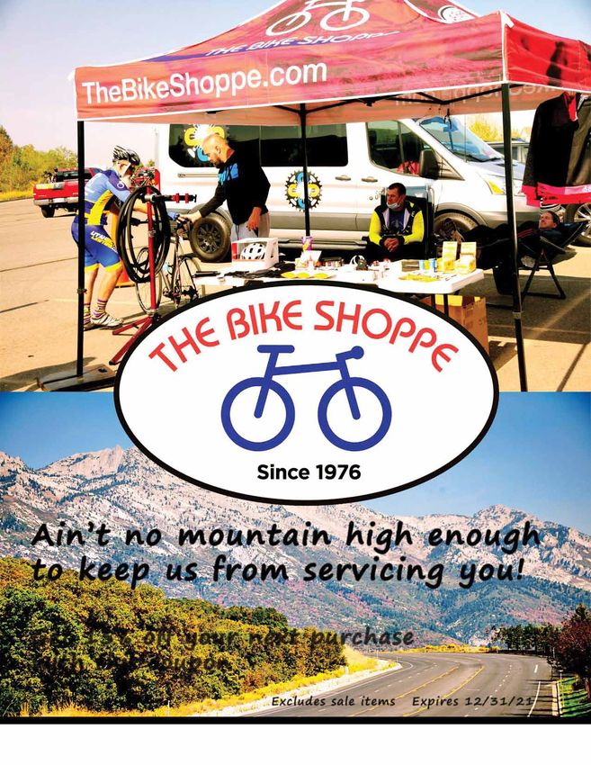
Ain’t no mountain high enough
 to keep us from servicing you!

 Get 15% off your next purchase
 with this coupon
                        Excludes sale items   Expires 12/31/21

The Bike Shoppe   thebikeshoppe.com            801-476-1600
ITINERARY
THURSDAY JUNE 10TH
Packet Pick-up                               6:00 - 8:30 PM
    Helen M Knight Elementary (SE lot)
    505 N MiVida Dr Moab, UT 84532

FRIDAY JUNE 11TH
Event & Team Instructions                    15 minutes prior to start

RACE START — SOLO, Non-competitive           6:00 AM
            OPEN, Mixed 4, Mixed 8

RACE START — Non-competitive                 6:30 AM
              Men 4
              Men 8

RACE START — Competitive                     7:00 AM
              Women
              Men 4B
              Mixed 4, Mixed 8

RACE START — Competitive                     7:30 AM
              Men 4A
SATURDAY JUNE 12TH
FINISH LINE officially opens at Unity Park   9 :00 AM
      200 W 400 S Ivins, UT 84738
Competitive Categories Awards                TBA
Finish Line officially closes                8:30 PM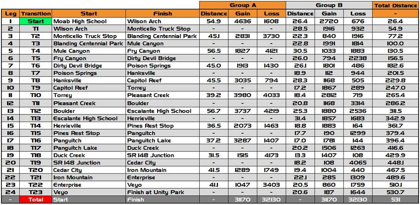
EVENT SUMMARY
RACE OVERVIEW
The Kokopelli Relay is a timed race covering approximately 532 miles of scenic highways and
back-country roads. The spirit of Kokopelli represents all that we love best about Southern
Utah, and it symbolizes abundance, freedom, goodwill, and mettle. During the relay, you or
one of your teammates will be in the saddle at all times as you race non-stop from Moab to
St. George. With over 32,000 feet of elevation gain, the course is sure to test your fitness as
well as your determination. Completing the course is an accomplishment worth bragging
about, and the passion of the Kokopelli will inspire you to finish strong!

RELAY FORMAT
Competitors in the race can participate as solo riders, or primarily in teams of four or eight
cyclists—although teams of other compositions may be permitted in the non-competitive
categories. Each team selects the rider for each leg, according to their strategies. Teams are
not required to utilize a particular rotation pattern; however, teams in the COMPETITIVE
categories must divide the number of legs evenly between all riders. Please refer to the Race
Bible for further explanation of category rules.
*** The Kokopelli Relay is non-supported. Team vehicles should plan to
    provide necessary nutrition, hydration, and other supplies. ***

START & FINISH TIMES
Start times are assigned based on the category that you will race in. Non-competitive
categories begin first and the competitive men’s categories start last. You must pay close
attention to when your group starts because your time will begin with the category start.
Your course time will be calculated based on your finish time minus your start time. You are
encouraged to use a personal GPS tracking device to log your ride. If an error is made in the
recording of your start or finish time, please notify the event staff as quickly as possible.

HOW TO READ THE MAPS
Each map shows two legs; Group A and Group B details are on the same map.
The MEN 4A category is the only category REQUIRED to use the Group A legs and
transitions. Any other group may, at their discretion, ride the Group A (the original 12 legs
from Rockwell Relay) or Group B legs. Group A shows the distance and elevation for BOTH
legs as if ONE LEG, and riders for Group A utilize only the even-numbered transition areas.
Group B shows the mileage and elevation for both legs.
For example, the map for legs 1-2, Group B, shows 26.4 (leg 1 distance) and 28.5 (leg 2
distance) as 26.4/28.5 whereas Group A sums the two, showing 54.9 miles. Group A will
have their first opportunity to transition at T2, and the second opportunity is at T4.
SAFETY IS OUR PRIORITY
SAFETY! SAFETY! SAFETY!

Safety is the most important thing of all. Road
cycling can be a dangerous sport.

There are obstacles such as rumble strips, potholes
and other road damage to be aware of, and then
there are those large motorized things to deal with.
While riding at night time, you MUST have adequate
lighting and a vest. Some will be riding a lot of
miles, and fatigue can become a serious issue…
But if you are aware of the potential for danger, we
can work together to mitigate risk, follow the rules
and use our best judgment. This way, we will all
have a blast and accomplish something great.

      The most important thing is that
     cyclists follow all road regulations.

Following the rules and guidelines will decrease the
possibility of accidents. There is no need to take
unnecessary risks. Any who are found not obeying
road regulations will be disqualified from the event.
We can not tolerate the risks and hazards that
come from disobeying road regulations.

“The Law” is Always Watching
A Course Official, “The Law”, will be driving the course during event hours, looking for rule violators
and safety hazards. They have the authority to disqualify any team or give time penalties or any
other consequence they see fit. They are there to help keep the event safe. Please treat them with
respect and inform them if you see any problems. For safety purposes, we require that you follow
certain guidelines. Be sure to read and understand the safety section in its entirety to avoid
problems, disqualification or accidents.
SAFETY CONTINUED
The Kokopelli Relay is an open course, long-            REFLECTIVE CLOTHING
distance event. Each cyclist or vehicle driver must     Reflective clothing is required by UDOT.
be responsible for his or her personal safety, as       Without exception, riders must wear a reflective
well as the safety of other participants, race          safety vest between the hours of 8:30 PM and
officials, and the general public. The race directors   6:30 AM.
reserve the right to disqualify any participants
posing a safety risk to themselves or others.           Obey traffic laws
HELMETS ARE MANDATORY FOR ALL RIDERS                    Cyclists must obey all traffic signals and lane
ANY TIME THEY ARE ON THE BIKE FOR THE                   travel laws. Please stop at all traffic signals and
DURATION OF THE EVENT.                                  stop signs. Even though this is a planned event,
                                                        it’s an open course and all bikers are subject to
CLIMATE                                                 traffic laws.
Temperatures along the course can vary widely:
from below 32 degrees (at night, in the mountain        SUPPORT VEHICLES
passes) to over 100 degrees (mid-day, in the            Obey all traffic laws. Obey posted speed limits.
desert). Sun, snow, rain and wind are all possible.     Allow plenty of travel time between exchanges
Plan your gear accordingly, for both extreme heat       so you are not tempted to speed or take
and cold. Please have at least 10 gallons of            unnecessary risks. Support vehicles are not
water/fluids in your support vehicle, particularly      allowed to impede highway traffic in any way.
between exchanges 1 and 10, where water sources         You may leapfrog your rider to cheer for them
are very limited. In addition, pack plenty of           at various points along the route, but only stop
cold-weather gear. Once again, bring adequate           in areas where you can pull completely off the
clothing, food, and fluids for every condition. Be      road. UDOT has issued our permit on the basis
prepared!                                               that our support vehicles will not impede the
                                                        flow of traffic.
NIGHT RIDING                                            FAILURE OF CYCLIST OR MOTORIST TO
Each rider must have a white front light that is
                                                        FOLLOW TRAFFIC LAWS WILL RESULT IN
visible from at least 500 feet and a red rear light,
                                                        IMMEDIATE DISQUALIFICATION.
also visible from 500 feet. The rechargeable,
                                                        In case of a life threatening emergency, call 911
high-wattage types are recommended, and you
                                                        for local emergency services. Please report all
should have two sets and a car charger. If you are
                                                        injuries or accidents to a director:
not using the rechargeable type, be sure to have
an adequate supply of batteries. All riders are
                                                        Cameron Scott             662-306-0407
encouraged to carry a backup light. This could be       Clay Christensen          801-234-0399
a headlamp. While riding, be particularly watchful
for cattle guards (there are several) and other         Over the course of the race, local emergency
road hazards. Do not ride faster than what your         responders may not be able to arrive at a given
lights can reveal. Support vehicles are encouraged      spot for some time. Support vehicles should
to stay near their riders during night hours,           carry a first-aid kit and other supplies deemed
without impeding the flow of traffic. Be smart and      necessary for an emergency, and stay in the
safe. Use the shoulder, ride single-file, listen for    general proximity of their riders (especially at
traffic, etc. Don’t assume motorists will see you.      night).
TRACKING YOUR TEAM
TRACKING
kokopellirelay.com/live-tracking/

trackleaders.com/kokopellirelay2021

The Kokopelli Relay 2021 edition will be using Trackleaders.com to track our teams. To clarify, this
is a “Tracker” not a timing chip. There are no chutes, timing pads, or gates to ride through. Simply
hand off the tracker “baton style” to the next rider after each transition. The tracker allows us to
know where all riders are at any given point in time...and it allows you to keep tabs on the other
teams to reel them in and crush their hopes and dreams!
The tracker follows riders in real time and reports back every 5 minutes. This 5-minute gap means
there is a chance you will see your rider in person before you see them at your location on the
tracker. You can follow as a support team, or tell your family and friends to watch from home.

The trackleaders tracking site will give you all sorts of good info like average speed,
estimated arrival time, leader board, etc.

INSTRUCTIONS
1 ) Do not touch the buttons unless instructed to by a Kokopelli Relay Representative
2) Remember to put the tracker in your jersey pocket with the SPOT logo facing
    out; that is where the antenna can get the best satellite reception
3) Hand the tracker off to the next rider at each exchange and let them continue down course
4) Make sure to share your team’s tracking info so everyone at home can follow
   you on your adventure!
CONTESTS BEST VIDEO Your team movie must be submitted by June 27th, 2021, before 11:59:59 PM. • Your video should tell us about your team’s experience during the Kokopelli Relay. • It CANNOT exceed 4 minutes in length. • Upload your video to YouTube and then send it in a private message to the official Kokopelli Relay Facebook page. We will then share each submitted video via our page for the contest. • Once we have posted your video be sure to share it with as many of your friends as possible and get them to like it on the official Kokopelli Relay Facebook page, because the video with the most combined “likes” (on our Facebook wall) AND total “likes” (thumbs up) on YouTube as of midnight on July 6th, 2021 will be declared the winner. Your video can take any approach you desire: power, beauty, comedy, or drama. You can create still shots in a slide show, continuous video, or a combination of both; but your video must in edited video format so it can be uploaded to YouTube. Now, let the creative juices start flowing and see if you can submit the video that will win a free entry to the 2022 Kokopelli Relay! The winner will be announced during the week of the submission deadline. To be clear, we will only be counting the number of “likes” on each video received as of midnight on July 6th, 2021. You may NOT hold a sweepstakes or offer any kind of reward or prize to friends, family, or followers in an effort to acquire more votes. BEST PHOTO Bring your camera along, because if everyone does, we should have nearly 250 photographers along the course route! Not only will you be able to capture unforgettable memories, but if your picture is chosen as one of our best pictures you will win an awesome prize! • To be entered, you must submit your photos to cameron@enduranceutah.com in full resolution within 1 week of the event ending: by 11:59 pm on June 19th. • Voting will take place on Facebook and winner will be announce during the week of June 24th.
The

 The winner of the
2021 photo contest
   will receive a
   Sherpa 2.0
 courtesy of Küat!
S
                                                                                                           Watch for the Hole-In-The-Rock
                                                                                                           around mile 16 and Wilson Arch
                                                                                                                  around mile 26

MOAB TO WILSON ARCH
   TO MONTICELLO

    GROUP A                         GROUP B
      54.9 MILES               26.4/28.5 MILES
      4636' UP                 2720/1916' UP
      1608' DOWN               676/932' DOWN

                      RIDER INFO                                                                                     1

RIDE CONDITIONS: Shoulder
NET CHANGE: (A) 3028; (B) 2044, 984
RELAY MILEAGE: (A) 54.9; (B) 26.4, 54.9
                       Turn By Turn
0.2 - Right onto Fourth East
0.5 - Left onto Hwy 191
26.4 - GROUP B Transition on right
26.4 - Continue on Hwy 191
54.9 - A & B Transition on right

     SUPPORT VEHICLE INFO
LEGEND
RESTROOMS: Moab (0.0), T1 (26.4), T2(54.9)
GAS: Moab (0.0), Monticello (54.9)
FOOD: Moab (McDonalds, Burger King),
Monticello (Subway)
ROAD CONDITION: Good
TRANSITIONS: T1 - Pull Out; T2 - Parking Lot
TRANSITION ADDRESSES:
T1 - Wilson Arch Hwy 191, Moab
T2 - 100 N & Hwy 191, Monticello

                                                                                                                              2

                                                                            Source: Esri, DigitalGlobe, GeoEye, Earthstar Geographics, CNES/Airbus DS, USDA,
                                                                                                           USGS, AeroGRID, IGN, and the GIS User Community
                                                             ELEVATION PROFILE
  7,000

  6,500
                                                                        1
  6,000

  5,500

  5,000

  4,500

          0   2   4    6   8   10   12   14   16   18   20    22   24        26    28       30   32   34   36   38       40   42   44   46   48   50   52
                                                                    Distance (miles)
GASOLINE WARNING!!! After the turn off at State Road
95, the next gasoline is in Hanksville, 121 miles
away. Make sure to fill up in Monticello, Blanding,
or the gas station at the corner of 191 and 95.
AT MULE CANYON, YOU MUST NOT IMPEDE TRAFFIC
OR THE ENTRY/EXIT OF OTHER VEHICLES IN/OUT
OF THE PARKING LOT. TRANSITIONS ON ROAD ARE
STRICTLY PROHIBITED. YOU MUST PARK, WAIT, AND
TRANSITION OFF OF THE ROAD. SEE RACE BIBLE FOR
MONTICELLO TO BLANDING TO DETAILS ON PARKING, TRANSITIONS & PENALTIES.
MULE CANYON 2
GROUP A GROUP B
45.1 MILES 22.3/22.8 MILES
2831' UP 840/1991' UP
3730' DOWN 1916/1814' DOWN
RIDER INFO
RIDE CONDITIONS: Shoulder
NET CHANGE: (A) -899; (B) -1076, 177
RELAY MILEAGE: (A) 100, (B) 77.2, 100
Turn By Turn
0.0 - Continue south on Hwy 191
20.7 - Left onto Hwy 191/Main St
22.3 - GROUP B ONLY Right onto Rogers Ln
22.8 - GROUP B Transition on right
3
22.8 - GROUP B ONLY East on Rogers Ln
22.9 - GROUP B ONLY Right onto Hwy 191/Main St
25.1 - Right onto UT-95 (Shirttail Corner)
45.1 - A&B Transition on right
4
SUPPORT VEHICLE INFO
RESTROOMS: Blanding (20.5), T4 (45.1)
GAS: Blanding (20.5), Shirt Tail Junction (25.1)
FOOD: Blanding (A&W, Subway, Clark's Market)
ROAD CONDITION: Good
TRANSITIONS: T3 - City Park; T4 - Pull Out
TRANSITION ADDRESSES:
T3 - 1200 S 300 W, Blanding
T4 - UT-95 (37.540214, -109.745299)
Source: Esri, DigitalGlobe, GeoEye, Earthstar Geographics, CNES/Airbus DS, USDA,
USGS, AeroGRID, IGN, and the GIS User Community
ELEVATION PROFILE
7,200
6,800
6,400
3
6,000
5,600
5,200
0 2 4 6 8 10 12 14 16 18 20 22 24 26 28 30 32 34 36 38 40 42 44
Distance (miles)MULE CANYON TO FRY CANYON
TO DIRTY DEVIL BRIDGE
GROUP A GROUP B
56.5 MILES 30.5/26 MILES
1827' UP 1033/794' UP
4121' DOWN 1883/2238' DOWN
SUPPORT VEHICLE INFO RIDER INFO
RESTROOMS: T5 (30.5), T6 (56.5) RIDE CONDITIONS: Shoulder, Narrow Shoulder
GAS: None NET CHANGE: (A) -2294; (B) -850, -1444
FOOD: None RELAY MILEAGE: (A) 156.5; (B) 130.5, 156.5
ROAD CONDITION: Good
TRANSITIONS: T5 - Pull Out; T6 - Gravel Lot
Turn By Turn
0.0 - Continue on UT-95
TRANSITION ADDRESSES:
30.5 - GROUP B Transition on left
T5 - UT-95 (37.64073, -110.16264)
56.5 - A & B Transition on right
T6 - UT-95 (37.91928, -110.38845)
6
Enjoy a gradual downhill leading to the Colorado River
at the beginning of Lake Powell, then through the
Natural Bridges National Monument. As you approach
Lake Powell, you will cross the Colorado River bridge,
followed by the Dirty Devil Bridge.
5
4
Source: Esri, DigitalGlobe, GeoEye, Earthstar Geographics, CNES/Airbus DS, USDA, USGS, AeroGRID, IGN, and the GIS User Community
ELEVATION PROFILE
7,000
6,500
6,000
5,500 5
5,000
4,500
4,000
0 2 4 6 8 10 12 14 16 18 20 22 24 26 28 30 32 34 36 38 40 42 44 46 48 50 52 54 56
Distance (miles)This leg climbs gradually up from Lake Powell
8
to a plateau summit, followed by a gradual
descent into Hanksville.
DIRTY DEVIL BRIDGE TO
POISION SPRINGS TO HANKSVILLE
GROUP A GROUP B
45 MILES 26.1/18.9 MILES
1913' UP 1801/112' UP
1430' DOWN 486/944' DOWN
RIDER INFO
RIDE CONDITIONS: Narrow Shoulder
NET CHANGE: (A) 483; (B) 1315, -832
RELAY MILEAGE: (A) 201.5; (B) 182.6, 201.5
Turn By Turn 7
0.0 - Continue on UT-95
26.1 - GROUP B Transition on right
45.0 - A & B Transition on right
SUPPORT VEHICLE INFO
RESTROOMS: T7 (26.1), T8 (45.0)
GAS: Hanksville (45.0)
FOOD: Hanksville (Blondie's, Stan's Burgers)
ROAD CONDITION: Good
TRANSITIONS: T7 - Pull Out; T8 - Parking Lot
TRANSITION ADDRESSES:
T7 - UT-95 (38.11712, -110.62306)
T8 - Hollow Mountain Gas Station,
40 N UT-95, Hanksville
6
Source: Esri, DigitalGlobe, GeoEye, Earthstar Geographics, CNES/Airbus DS, USDA,
USGS, AeroGRID, IGN, and the GIS User Community
ELEVATION PROFILE
7
5,000
4,800
4,600
4,400
4,200
4,000
3,800
0 2 4 6 8 10 12 14 16 18 20 22 24 26 28 30 32 34 36 38 40 42 44
Distance (Miles)HANKSVILLE TO
CAPITOL REEF TO TORREY
GROUP A GROUP B
45.5 MILES 28.3/17.2 MILES
3035' UP 1168/1867' UP
794' DOWN 505/289' DOWN
SUPPORT VEHICLE INFO RIDER INFO
RESTROOMS: T9 (28.3), T10 (45.5) RIDE CONDITIONS: Narrow Shoulder
GAS: T10 (45.5) NET CHANGE: (A) 2241; (B) 663, 1578
FOOD: T10 (La Cueva Mexican Restaurant, Subway) RELAY MILEAGE: (A) 247; (B) 229.8, 247
ROAD CONDITION: Good
Turn By Turn
TRANSITIONS: T9 - Pull Out; T10 - Gas Station
TRANSITION ADDRESSES: 0.1 - Veer left onto UT-24
T9 - Shoulder Pull Out, SR-24 (38.28374,-111.12786) 28.3 - GROUP B Transition on right
T10 - Torrey PetroUS, 875 N SR-24, Torrey 45.5 - A & B Transition on right
There is a significant climb that follows the Fremont River
most of the way. Around mile 29 you will enter Capitol
Reef National Park. The historical town of Fruita is several
miles later. The aroma of La Cueva’s delicious Mexican
food will be beckoning you to the Torrey Exchange,
La Cueva and the general store will stay open until 1 AM
to service us!
8
10
9
Source: Esri, DigitalGlobe, GeoEye, Earthstar Geographics, CNES/Airbus DS, USDA, USGS, AeroGRID, IGN, and the GIS User Community
ELEVATION PROFILE
6,400
6,000
5,600
5,200
9
4,800
4,400
0 2 4 6 8 10 12 14 16 18 20 22 24 26 28 30 32 34 36 38 40 42 44
Distance (miles)10
TORREY TO PLEASANT CREEK
TO BOULDER
GROUP A GROUP B
39.2 MILES 18.4/20.8 MILES
3980' UP 2812/1168' UP The steep climb from Torrey up
4033' DOWN 719/3314' DOWN UT-12 into the Boulder Mountains
has a false summit about 15 miles
RIDER INFO in. After a short descent and 5
RIDE CONDITIONS: Shoulder, Narrow Shoulder more miles of climbing, you will
NET CHANGE: (A) -53; (B) 2093, -2146 hit Boulder Pass and the KOM/QOM
RELAY MILEAGE: (A) 286.2; (B) 265.4, 286.2 segment. After the summit, be 11
cautious on the steep descent down
Turn By Turn to the quaint town of Boulder. As
0.0 - Continue SW on UT-24 you descend, watch for cattle, deer,
1.7 - Turn left onto UT-12 and elk on the road.
18.4 - GROUP B Transition on right
39.2 - A & B Transition on right
SUPPORT VEHICLE INFO
RESTROOMS: T11 (18.4), T12 (39.2)
GAS: Torrey (1.7), T12 (39.2)
FOOD: None
ROAD CONDITION: Good
TRANSITIONS: T11 - Pull Out, T12 - Gas Station
TRANSITION ADDRESSES:
T11 - FR247 & UT-12 (38.107722, -111.338389)
T12 - Hills & Hollows Market,
840 UT-12, Boulder
Gnarly Nutrition will sponsor the KOM/QOM
for 2021. Check the Event Bible for details
and the link for the segment on Strava.
Winners will receive $50 gift card towards 12
Gnarly Nutrition products! Source: Esri, DigitalGlobe, GeoEye, Earthstar Geographics, CNES/Airbus DS, USDA,
USGS, AeroGRID, IGN, and the GIS User Community
ELEVATION PROFILE
9,500
9,000
11
8,500
8,000
7,500
7,000
6,500
0 2 4 6 8 10 12 14 16 18 20 22 24 26 28 30 32 34 36 38
Distance (miles)Fuel. Replenish. Recover.
Gnarly Nutrition's carb-based Fuel2O is your all-in-one
solution for long days on the road, trails, or in the mountains. 2021 SPONSOR
Push Your Possible with Gnarly Nutrition.
KOM & QOM
Fuel20 lets you charge harder Replenishment: 250mg of sodium plus
for longer and bounce back other electrolytes.
Gnarly Performance products
quicker through:
Recovery: HMB (a metabolite of the are intended to be taken
Fueling: Contains 100 calories branched chain amino acid leucine to help during exercise and activity.
of easy-to-digest carbs minimize muscle protein breakdown).
that won’t cause stomach issues. :MXEQMR(XSMQTVSZIFIRIƥXWSJ,1& Try Fuel20 today at GoGnarly.comBOULDER TO ESCALANTE
HS TO HENRIEVILLE
GROUP A GROUP B
56.7 MILES 25.3/31.4 MILES
3737' UP 1880/1857' UP
4219' DOWN 2536/1683' DOWN
SUPPORT VEHICLE INFO RIDER INFO
RESTROOMS: T13 (25.3), T14 (56.7) RIDE CONDITIONS: Shoulder, Narrow Shoulder
GAS: Escalante (25.7) NET CHANGE: (A) -482; (B) -656, 174
FOOD: Escalante (Subway) RELAY MILEAGE: (A) 342.9; (B) 311.5, 342.9
ROAD CONDITION: Good
TRANSITIONS: T13 - Parking Lot, T14 - Parking Lot Turn By Turn
TRANSITION ADDRESSES: 0.0 - Continue on UT-12
T13 - Escalante High School 25.3 - GROUP B Transition on right
800 E Hwy 12, Escalante 56.7 - A & B Transition on right
T14 - Henrieville Visitor Center, ***PLEASE BE RESPECTFUL, CLEAN AND QUIET WHILE
100 West & SR-12, Henrieville ENTERING AND EXITING THE TOWN OF HENRIEVILLE ***
12
As you descend from Boulder down to the Escalante
River, you will ride along a ridge with steep drop offs
on both sides of the road. Shortly after climbing up
from the river on the other side you come to a windy
section of road that contours a rugged white slickrock.
13
14
Source: Esri, DigitalGlobe, GeoEye, Earthstar Geographics, CNES/Airbus DS, USDA, USGS, AeroGRID, IGN, and the GIS User Community
ELEVATION PROFILE
7,200
6,800
6,400
6,000 13
5,600
5,200
0 2 4 6 8 10 12 14 16 18 20 22 24 26 28 30 32 34 36 38 40 42 44 46 48 50 52 54 56
Distance (miles)HENRIEVILLE TO PINES
REST STOP TO PANGUITCH
GROUP A GROUP B
36.5 MILES 18.8/17.7 MILES
2073' UP 1883/190' UP
1436' DOWN 164/1299' DOWN
SUPPORT VEHICLE INFO RIDER INFO
RESTROOMS: T15 (18.8), T16 (36.5) RIDE CONDITIONS: Shoulder
GAS: Cannonville (3.5), Tropic (8.2), T16 (36.5) NET CHANGE: (A) 610; (B) 1719, -1109
FOOD: Panguitch (Subway, Joe's Market, C-Stop) RELAY MILEAGE: (A) 379.4; (B) 361.7, 379.4
ROAD CONDITION: Good
TRANSITIONS: T15 - Rest Area, T16 - Parking Lot Turn By Turn
TRANSITION ADDRESSES: 0.0 - Continue on UT-12
T15 - UT-12 (37.70767, -112.20556) 18.8 - GROUP B Transition on right
T16 - 575 Center Street, Panguitch 29.2 - Right onto US-89
36.5 - A & B Transition on right
16
Shortly after (quietly) leaving Henrieville, pass through
the small towns of Cannonville and Tropic, then Bryce
Canyon National Park. The summit is located around
mile 14.5, followed by nearly 9 miles of plateau. After
you descend into Red Canyon, you will pass through 2
red rock tunnels near mileage 24.4. At the bottom of
Red Canyon, turn right at UT-89 and finish in Panguitch.
15
14
Source: Esri, DigitalGlobe, GeoEye, Earthstar Geographics, CNES/Airbus DS, USDA, USGS, AeroGRID, IGN, and the GIS User Community
ELEVATION PROFILE
15
7,600
7,200
6,800
6,400
6,000
0 2 4 6 8 10 12 14 16 18 20 22 24 26 28 30 32 34
Distance (miles)This leg boasts the steepest ascent with over 3200
feet of climbing over the 37 miles. You will start
climbing immediately out of Panguitch, entering
the Dixie National Forest as the high desert landscape
turns to mountain. Enjoy a short flat area around the
scenic Panguitch Lake after around 15.5 miles.
PANGUITCH TO PANGUITCH LAKE 16
TO DUCK CREEK
GROUP A GROUP B
37.2 MILES 17/20.2 MILES
3287' UP 1781/1506' UP
1407' DOWN 144/1263' DOWN
RIDER INFO
RIDE CONDITIONS: Shoulder
NET CHANGE: (A) 1880; (B) 1637, 243 17
RELAY MILEAGE: (A) 416.6; (B) 396.4, 416.6
Turn By Turn
0.0 - Continue west on Center
0.6 - Turn left onto UT-143/Main St
17.0 - GROUP B Transition on left
22.6 - Turn left onto FH 050
37.2 - A & B Transition on right
SUPPORT VEHICLE INFO
RESTROOMS: T17 (17), T18 (37.2)
GAS: Panguitch General Store (18.9)
FOOD: None
ROAD CONDITION: Good
TRANSITIONS: T17- Parking Lot, T18- Parking Lot
TRANSITION ADDRESSES:
T17 - Bear Paw Fishing Resort,
905 UT-143, Panguitch
T18 - UT-14 (37.5184, -112.64587)
18
Source: Esri, DigitalGlobe, GeoEye, Earthstar Geographics, CNES/Airbus DS, USDA,
USGS, AeroGRID, IGN, and the GIS User Community
ELEVATION PROFILE
8,400
17
8,000
7,600
7,200
6,800
0 2 4 6 8 10 12 14 16 18 20 22 24 26 28 30 32 34 36
Distance (miles)DUCK CREEK TO SR 148
TO CEDAR CITY
GROUP A GROUP B
31.5 MILES 13.3/18.2 MILES
1515' UP 1407/108' UP
4173' DOWN 108/4065' DOWN
SUPPORT VEHICLE INFO RIDER INFO
RESTROOMS: T19 (13.3), T20 (31) RIDE CONDITIONS: Shoulder, Narrow Shoulder
GAS: Duck Creek Village (0.2), Cedar City (31.5) NET CHANGE: (A) -2658; (B) 1299, -3957
FOOD: Cedar City (Arby's, McDonald's, Wendy's) RELAY MILEAGE: (A) 448.1; (B) 429.9, 448.1
ROAD CONDITION: Good
Turn By Turn
TRANSITIONS: T19- Parking Lot, T20- City Park 0.0 - Right onto UT-14 W
TRANSITION ADDRESSES: 13.3 - GROUP B Transition on right
T19 - SR-148 (37.57309, -112.83661) 31.1 - Right onto 200 E
T20 - Veteran's Park Basebal Fields, 31.5 - Slight right, turn into baseball field parking lot
407 E 275 N, Cedar City
A & B Transition on right
20
The climb along UT-14 will pass Duck Creek Village and
Lake before the long descent toward Cedar. Keep it safe
and enjoy the wonderful morning views of Cedar Canyon.
19
18
Source: Esri, DigitalGlobe, GeoEye, Earthstar Geographics, CNES/Airbus DS, USDA, USGS, AeroGRID, IGN, and the GIS User Community
ELEVATION PROFILE
19
9,500
9,000
8,500
8,000
7,500
7,000
6,500
6,000
0 2 4 6 8 10 12 14 16 18 20 22 24 26 28 30
Distance (miles)CEDAR CITY TO IRON
MOUNTAIN TO ENTERPRISE
GROUP A GROUP B
41.5 MILES 19.4/22.1 MILES
1289' UP 1004/285' UP
1749' DOWN 440/1309' DOWN
SUPPORT VEHICLE INFO RIDER INFO
RESTROOMS: T21 (19.4), T22 (41.5) RIDE CONDITIONS: Shoulder
GAS: Newcastle (30.0), Enterprise NET CHANGE: (A) -460; (B) 564, -1024
FOOD: None RELAY MILEAGE: (A) 489.6; (B) 467.5, 489.6
ROAD CONDITION: Good Turn By Turn
TRANSITIONS: T21- Pull Out, T22 - Parking Lot 0.0 - Exit lot heading W back down 200 E
TRANSITION ADDRESSES: 0.1 - Turn right onto 200 N
T21 - UT-56 (37.61121, -113.38267) Continue W as 200 N becomes UT-56
T22 - Enterprise Rodeo Grounds 19.4 - GROUP B Transition on right
30.2 - Turn left onto Main St (continue onto Bench Rd
100 N UT-18, Enterprise
39.3 - Turn left onto UT-18 S
41.5 - A & B Transition on right
After leaving Cedar City, climb 1000 feet to the Iron
Mountain pass. Once through the town of Newcastle,
turn left to follow the Bench Road through the
ranchlands until you arrive at Enterprise.
20
21
22
Source: Esri, DigitalGlobe, GeoEye, Earthstar Geographics, CNES/Airbus DS, USDA, USGS, AeroGRID, IGN, and the GIS User Community
ELEVATION PROFILE
6,400
21
6,200
6,000
5,800
5,600
5,400
0 2 4 6 8 10 12 14 16 18 20 22 24 26 28 30 32 34 36 38 40
Distance (miles)22
ENTERPRISE TO VEYO You're almost there, but don't
TO FINISH leave Veyo without stopping in
to The Original Veyo Pies & Bakery.
Call Friday to ensure they have the
GROUP A GROUP B pie you want: (435) 574-2132.
41.1 MILES 20.5/20.6 MILES Mention that you're part of the
1047' UP 860/187' UP Kokopelli Relay for $1 off a whole pie.
Seriously, if you don't get pie in Veyo
3403' DOWN 1759/1644' DOWN
we're giving your finisher's medal to
your Uncle Bob...
RIDER INFO
RIDE CONDITIONS: Shoulder, Narrow Shoulder
NET CHANGE: (A) -2356; (B) -899, -1457
RELAY MILEAGE: (A) 530.7; (B) 510.1, 530.7
Turn By Turn
0.3 - Turn left onto UT-18
20.6 - GROUP B Transition on left
20.6 - Turn right onto W Center St 23
23.2 - Turn left onto W Gunlock Rd
36.0 - Continue onto W Old Hwy 91
40.6 - Turn left onto Kwavasa, quick Right
onto 400 S
41.2 - FINISH LINE
SUPPORT VEHICLE INFO
RESTROOMS: T23 (20.5), Finish(41.1)
GAS: Veyo (20.5)
FOOD: Veyo Pies (20.5)
ROAD CONDITION: Good
TRANSITIONS: T23- Parking Lot, F - City Park
TRANSITION ADDRESSES:
T23 - Veyo Pies
24 S Main St, Veyo
F - 200 W 400 S, Ivins
F
Source: Esri, DigitalGlobe, GeoEye, Earthstar Geographics, CNES/Airbus DS, USDA,
USGS, AeroGRID, IGN, and the GIS User Community
ELEVATION PROFILE
6,000
5,500
5,000
23
4,500
4,000
3,500
3,000
0 2 4 6 8 10 12 14 16 18 20 22 24 26 28 30 32 34 36 38 40
Distance (miles)Kokopelli Relay
11OFFICIAL MERCHANDISE
$65
$115
$20
$25SE P TE M BE R 24 - 25
2021
USE PROMO CODE KOKOSMELLY FOR 10% OFF 2021 REGISTRATION!You can also read