2021 Q1.2 Map Release Notes - NORTH AMERICA - PC*MILER
←
→
Page content transcription
If your browser does not render page correctly, please read the page content below
2021 Q1.2 Map
Data Notes
Release

 NORTH AMERICA

                                                                                                         DISCLAIMER: Not all data components are
                                                                                                     available in all products or solutions. Additional
                                                                                                       licenses may apply for specific data content.

© 2021, Trimble Inc. All rights reserved Trimble, the Globe & Triangle Logo, PC*MILER, CoPilot, Appian, and MileOn are trademarks of Trimble
Inc., registered in the United States Patent and Trademark Office and/or in other countries. All other trademarks are the property of their respective
owners.
Table of Contents
   1. General Routing and Map Data ............................................................................. 3

   2. ZIP/Postal Code & City Point Data ............................................................................. 15

   3. SPLC Data ............................................................................................................ 21

   4. Toll Data ................................................................................................................. 22

   5. Places Data ............................................................................................................ 25

   6. Energy Data ............................................................................................................ 27

   7. Contact Information ............................................................................................... 29

Release Notes | 2021 Q1.2 Trimble MAPS Map Data Release Notes                                                              Page| 2
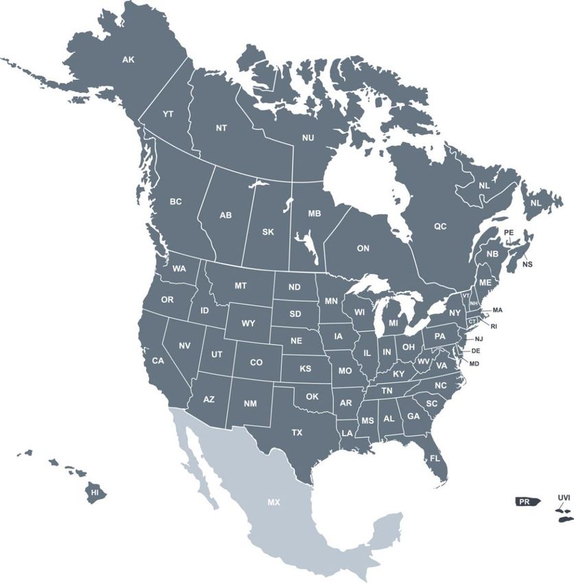
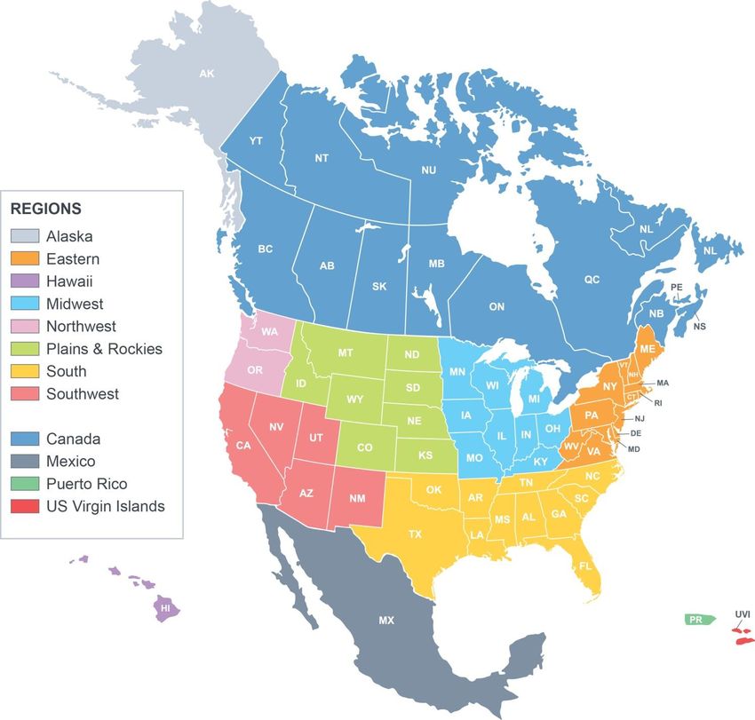
Section

               1
   Coverage & Statistics
                              2021 Q1.2 North America
                          General Routing and Map Data

                                     Highway and street-level
         COMPREHENSIVE               Includes cities, postal codes, addresses, truck attributes, Places, tolls

               HIGH
                                     Highway and street-level
                                     Includes cities and postal codes with limited addresses, truck attributes and Places

           INTERMEDIATE
                                     Basic highway-level network
                                     Includes cities, postal codes, limited Places

Release Notes | 2021 Q1.2 Trimble MAPS Map Data Release Notes                                                         Page| 3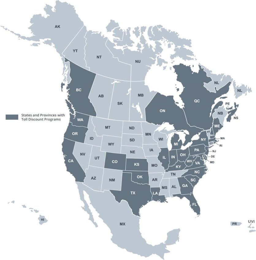
STREET-LEVEL                     HIGHWAY-LEVEL
                       NETWORK IN MILES                 NETWORK IN MILES                  LEVEL OF
                                                                                         COVERAGE
                       21Q1.2   previous                21Q1.2    previous
      UNITED
                       6,709,641        6,702,098       869,842          869,585         Comprehensive
      STATES
     PUERTO
                         26,028          26,028          3,080            3,080               High
       RICO
    US VIRGIN
                         1,386            1,386           199              199                High
     ISLANDS
     CANADA             876,922          876,499        142,415          142,333         Comprehensive

      MEXICO            368,077          368,040        98,589           98,587           Intermediate

                                                    ADDRESS COVERAGE*
                                        21Q1.2                               previous quarter
       UNITED
                        3,318,833 miles of addressed roads          3,319,189 miles of addressed roads
       STATES
   PUERTO RICO            1,675 miles of addressed roads               1,675 miles of addressed roads
     US VIRGIN
                                  There are no addressed roads in the US Virgin Islands at this time
      ISLANDS
      CANADA             288,589 miles of addressed roads            288,560 miles of addressed roads

       MEXICO                           There are no addressed roads in Mexico at this time

   *Excludes highways and any other roads that don’t have actual house numbers.

Release Notes | 2021 Q1.2 Trimble MAPS Map Data Release Notes                                            Page| 4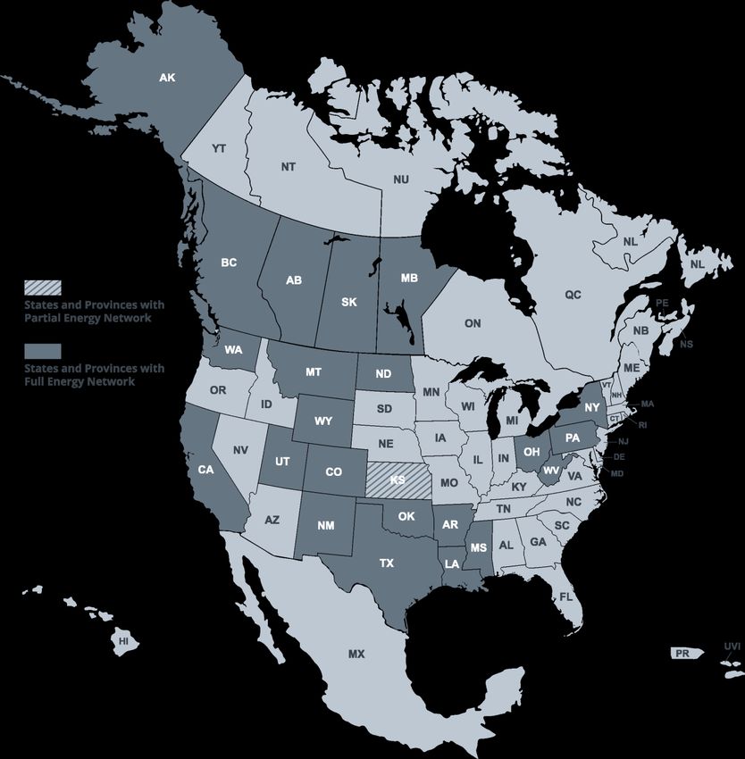
Summary of Key Updates
Updates in this North America data release include:
Updates to the road network were made in 354 counties
33 new construction road projects were added
Truck attributes were updated; totaling more than 900,000 miles
Truck through-travel restrictions were updated within 32 city limits
Weight limits were updated in Quebec
Posted vertical clearances were reviewed and updated in Ohio
53’ routing attribution was reviewed and updated in California & Idaho
Tolls were updated to reflect new rates in Michigan & New York
City points and postal codes were updated for the US and Canada
6,572 new POIs added to the Places Database (3591 distribution centers & 2981
manufacturing plants)
6,226 new site locations were coded (3,325 distribution centers, 1 intermodal facility,
2,899 manufacturing plants and 1 truck stop)
More than 2,700 customer reported issues were fixed
More than 250 miles of new highway-level network was added to the United States
Release Notes | 2021 Q1.2 Trimble MAPS Map Data Release Notes Page| 5Select Regional Updates The release notes are grouped into the following regions. Please note that only select updates are summarized. Other enhancements may also be included in this release. Release Notes | 2021 Q1.2 Trimble MAPS Map Data Release Notes Page| 6
ALASKA
Region NEW CONSTRUCTION & OTHER UPDATES
Updates to the road network were made in the following counties:
Denali Borough, Fairbanks North Star Borough, Hoonah-Angoon
ALASKA Census Area, Skagway Municipality, Wade Hampton Census Area,
Wrangell City and Borough, Yukon-Koyukuk Census Area
EASTERN region
State NEW CONSTRUCTION & OTHER UPDATES
I-91, MA-9 and Damon Road Roundabout – The intersection of I-91
northbound exit ramp, MA-9 and Damon Road was reconfigured into a
MASSACHUSETTS
roundabout. Northampton, MA 42.333515N, 72.620668W
Updates to the road network were made in the following counties: Oxford,
MAINE Penobscot, Piscataquis, Sagadahoc, Somerset, Waldo, Washington
NY-5 S and John Street Roundabout – The intersection of NY-5 S and
John Street was reconfigured into a roundabout. Utica, NY 43.101932N,
75.226241W
NEW YORK
Updates to the road network were made in the following counties:
Montgomery, New York
PENNSYLVANIA Updates to the road network were made in the following county: Delaware
RI-146 and RI-116 Interchange – The ramp from westbound RI-116 to
southbound RI-146 has been demolished. Lincoln, RI 41.935694N,
71.468851W
RI-146 and RI-116 Interchange – Ramp from southbound RI-146 to
RHODE ISLAND
eastbound RI-116 has been demolished. Lincoln, RI 41.9339N, 71.466066W
Updates to the road network were made in the following counties: Bristol,
Kent, Newport
Updates to the road network were made in the following counties: Addison,
VERMONT
Bennington, Caledonia, Essex, Franklin, Grand Isle, Lamoille
Transform 66 Exit 53 – Interchange of I-66 and VA-28 was reconfigured
with flyovers. Centerville, VA 38.846519N, 77.432154W
Transform 66 Braddock Road/Walney Road Overpass – The intersection
of VA-28 and Braddock Road/Walney Road was reconfigured into a viaduct
VIRGINIA
overpassing VA-28. Centerville, VA 38.851598N, 77.432853W
Greenwich Road Flyover – A new flyover across I-264 connecting
Greenwich Road and Clearfield Avenue. Virginia Beach, VA 36.845025N,
76.170248W
Release Notes | 2021 Q1.2 Trimble MAPS Map Data Release Notes Page| 7 VA-9 and VA-719 Roundabout – The intersection of VA-9 and VA-719 was
reconfigured into a roundabout. Hillsboro, VA 39.200189N, 77.727688W
VA-9 and VA-690 Roundabout – The intersection of VA-9 and VA-690 was
reconfigured into a roundabout. Hillsboro, VA 39.198101N, 77.720014W
Updates to the road network were made in the following counties:
Albemarle, Isle of Wight, King and Queen, Rockingham, Waynesboro
State TRUCK-SPECIFIC UPDATES
Truck through-travel restrictions were updated in the following areas:
MASSACHUSETTS
Amesbury, Auburn
Truck through-travel restrictions were updated in the following areas:
NEW HAMPSHIRE
Conway
Truck through-travel restrictions were updated in the following areas:
NEW JERSEY
Bayville, Gloucester
Truck through-travel restrictions were updated in the following areas:
PENNSYLVANIA
Antrim, East McKeesport Borough
Truck through-travel restrictions were updated in the following areas:
VIRGINIA
Colonial Heights
HAWAII
There are no changes to report for this region.
MIDWEST region
State NEW CONSTRUCTION & OTHER UPDATES
US-20 and Harmony Road Roundabout – The intersection of US-20 and
Harmony Road was reconfigured into a roundabout. Marengo, IL
ILLINOIS
42.161158N, 88.52669W
East 96th Street and Sargent Road Roundabout – The intersection of
East 96th Street and Sargent Road was reconfigured into a roundabout.
Fishers, IN 39.927074N, 86.006133W
South Arlington Avenue, Churchman Bypass and Big Four Road
INDIANA Roundabout – The intersection of South Arlington Avenue, Churchman
Bypass and Big Four Road was reconfigured into a roundabout.
Indianapolis, IN 39.7125N, 86.063613W
Updates to the road network were made in the following county: Howard
I-29 Improvement Project Segment 2 – I-29 Exit 147 was reconfigured
IOWA
between Hamilton Boulevard and Floyd Boulevard. Sioux City, IA
Release Notes | 2021 Q1.2 Trimble MAPS Map Data Release Notes Page| 842.491569N, 96.412986W
Updates to the road network were made in the following counties: Bremer,
Poweshiek
Updates to the road network were made in the following counties: Allen,
KENTUCKY
Anderson, Campbell, Garrard, Jessamine, Nelson, Oldham, Spencer
Updates to the road network were made in the following counties:
MICHIGAN Livingston, Oakland
Updates to the road network were made in the following counties: Cook,
Douglas, Mille Lacs, Nicollet, Nobles, Norman, Otter Tail, Pennington,
MINNESOTA Pope, Red Lake, Renville, Sibley, St. Louis, Stevens, Todd, Traverse,
Wabasha, Wadena, Waseca, Wilkin, Wright ,Yellow Medicine
Updates to the road network were made in the following counties: Butler,
Callaway, Dent, Dunklin, Gasconade, Grundy, Henry, Hickory, Howell,
Iron, Jasper, Mercer, Miller, Moniteau, Morgan, New Madrid, Newton,
MISSOURI
Nodaway, Perry, Pettis, Polk, Scotland, Scott, St. Louis City, Stoddard,
Texas, Vernon
US-20 Alternate and Weckerly Road – The intersection of US-20 Alternate
and Weckerly Road was reconfigured into a roundabout. Monclova, OH
41.573692N, 83.766878W
OH-241 and Raber Road Roundabout – The intersection of OH-241 and
Raber Road was reconfigured into a roundabout. Green, OH 40.966506N,
81.46516W
OH-241 and Stein Road Roundabout – The intersection of OH-241 and
Stein Road was reconfigured into a roundabout. Akron, OH 40.969964N,
OHIO 81.465083W
County Route 24 and North McCord Road Roundabout – The
intersection of County Route 24 and North McCord Road was reconfigured
into a roundabout. Toledo, OH 41.653978N, 83.70289W
County Route 24 and Windjammer Apartments Driveway Roundabout –
The intersection of County Route 24 and Windjammer Apartments Driveway
was reconfigured into a roundabout. Toledo, OH 41.653952N, 83.699121W
Updates to the road network were made in the following counties:
WISCONSIN Menominee, Pierce, Waushara
State TRUCK-SPECIFIC UPDATES
Truck through-travel restrictions were updated in the following areas: Alsip,
ILLINOIS
Chicago, Zion
MICHIGAN Truck through-travel restrictions were updated in the following areas:
Release Notes | 2021 Q1.2 Trimble MAPS Map Data Release Notes Page| 9Bangor Charter, Benton Harbor
MINNESOTA Truck through-travel restrictions were updated in the following areas: Blaine
MISSOURI Truck through-travel restrictions were updated in the following areas: Arnold
Truck through-travel restrictions were updated in the following areas:
OHIO Bexley, Clinton
Posted vertical clearances were reviewed and updated
NORTHWEST region
State NEW CONSTRUCTION & OTHER UPDATES
Updates to the road network were made in the following counties: Benton,
OREGON Lane, Washington
Updates to the road network were made in the following counties: Benton,
WASHINGTON
Pend Oreille, San Juan, Skamania, Wahkiakum, Whitman
PLAINS and ROCKIES region
State NEW CONSTRUCTION & OTHER UPDATES
North Boyd Lake Avenue and East 15th Street Roundabout – The
intersection of North Boyd Lake Avenue and East 15th Street was
reconfigured into a roundabout. Loveland, CO 40.409328N, 105.021043W
COLORADO
Updates to the road network were made in the following counties: Crowley,
Custer, Fremont, Garfield , Gilpin, Lake, Mineral, Park, Saguache,
Washington, Weld
Updates to the road network were made in the following counties: Boise,
IDAHO
Bonneville, Owyhee, Valley
Updates to the road network were made in the following counties: Allen,
Brown, Cherokee, Edwards, Franklin, Johnson, Lane, Marion, Marshall,
Miami, Mitchell, Osborne, Ottawa, Pottawatomie, Pratt, Rawlins, Reno,
KANSAS
Republic, Rice, Riley, Scott, Seward, Sheridan, Sherman, Stanton,
Stevens
Updates to the road network were made in the following counties:
MONTANA Broadwater, Carbon, Gallatin, Granite, Jefferson, Lake, Park,
Petroleum, Sanders
Crown Point Avenue Project – Four new roundabout have been added to
NEBRASKA Crown Point Avenue at the intersections of Wenninghoff Road, Northwest
High School west entrance, Northwest High School east entrance and 78th
Release Notes | 2021 Q1.2 Trimble MAPS Map Data Release Notes Page| 10Street. Omaha, NE 41.312698N, 96.038675W
Updates to the road network were made in the following county: Morton
NORTH DAKOTA
Updates to the road network were made in the following counties: Clark,
SOUTH DAKOTA Custer, Lake, Meade, Oglala Lakota, Sanborn
Updates to the road network were made in the following counties: Lincoln,
WYOMING Natrona, Sublette, Teton
State TRUCK-SPECIFIC UPDATES
IDAHO 53’ routing attribution was reviewed and updated
SOUTH region
State NEW CONSTRUCTION & OTHER UPDATES
ALABAMA Updates to the road network were made in the following county: Limestone
Updates to the road network were made in the following counties: Charlotte,
Dixie, Flagler, Gilchrist, Glades, Hernando, Jefferson, Lake, Lee, Pasco,
FLORIDA
Polk, St. Johns
Transform 400/285 Project – Ramp between southbound GA-400(US-19)
and westbound I-285 was reconfigured. Sandy Springs, GA 33.911774N,
84.357209W
GEORGIA Updates to the road network were made in the following counties: Barrow,
Bulloch, Catoosa, Effingham, Emanuel, Floyd, Franklin, Glynn, Gordon,
Henry, Jackson, Jasper, Lamar , Long, Lumpkin, Madison, Morgan
Muscogee
LA-42 Superstreet – LA-42 from US-61 to LA-44 has been reconfigured into
a superstreet with reduced conflict interchanges at all major junctions.
Prairieville, LA 30.320641N, 90.94517W
LOUISIANA
I-20 Exit 83 – New diamond ramp at I-20 and Tarbutton Road is now open
to traffic. Ruston, LA 32.540591N, 92.677917W
Updates to the road network were made in the following counties:
NORTH Brunswick, Cabarrus, Hoke, Johnston, Lincoln, Scotland, Stokes,
CAROLINA Swain
I-35 Exit 104 Roundabout – The intersection of I-35 northbound exit and
OKLAHOMA
entrance ramps and OK-74 was reconfigured into a roundabout. Goldsby,
Release Notes | 2021 Q1.2 Trimble MAPS Map Data Release Notes Page| 11OK 35.156391N, 97.477044W
I-35 and OK-74 Ramp – New ramp from southbound I-35 to OK-74 is now
open to traffic. Goldsby, OK 35.150408N, 97.4754W
Updates to the road network were made in the following counties: Bamberg,
SOUTH
Calhoun, Chesterfield, Kershaw, Spartanburg, Williamsburg
CAROLINA
US-27 Exit 1B and 1C Ramps – Reconfiguration of ramps at US-27 and
TN-389 & US-27 and TN-316. Chattanooga, TN 35.050566N, 85.314279W
Updates to the road network were made in the following counties: Benton,
Bledsoe, Blount, Bradley, Campbell, Cannon, Carroll, Carter,
TENNESSEE Cheatham, Chester, Claiborne, Clay, Cocke, Crockett, Davidson,
Decatur, Dyer, Fentress, Franklin, Gibson, Giles, Grainger, Greene,
Grundy, Hamblen, Hamilton, Hancock, Hardeman, Hardin, Hawkins,
Haywood, Henderson, Hickman, Houston, Humphreys
Updates to the road network were made in the following counties: Bandera,
Bastrop, Bell, Bosque, Burleson, Callahan, Cass, Cherokee, Coke,
Collin, Dallas, De Witt, Denton, Ellis, Erath, Franklin, Gillespie,
TEXAS Gonzales, Guadalupe, Hardin, Hays, Hudspeth, Jefferson, Kinney,
Knox, Leon, Navarro, Orange, Palo Pinto, Parker, Polk, Rains,
Robertson, Rockwall, Starr, Sterling, Victoria, Wise
State TRUCK-SPECIFIC UPDATES
Truck through-travel restrictions were updated in the following areas:
ALABAMA Anniston
Truck through-travel restrictions were updated in the following areas:
FLORIDA
Kissimmee
Truck through-travel restrictions were updated in the following areas:
LOUISIANA
Bastrop
NORTH Truck through-travel restrictions were updated in the following areas:
CAROLINA Asheville
Truck through-travel restrictions were updated in the following areas:
TENNESSEE
Bartlett
Truck through-travel restrictions were updated in the following areas:
TEXAS
Addison, Alice, Beeville, Corinth
Release Notes | 2021 Q1.2 Trimble MAPS Map Data Release Notes Page| 12SOUTHWEST region
State NEW CONSTRUCTION & OTHER UPDATES
Updates to the road network were made in the following counties:
ARIZONA
Coconino, Pima
CA-119, CA-43 and South Enos Lane Roundabout – The intersection of
CA-119, CA-43 and South Enos Lane was reconfigured into a roundabout.
Bakersfield, CA 35.267409N, 119.252711W
CA-43 and Stockdale Highway Roundabout – The intersection of CA-43
and Stockdale Highway was reconfigured into a roundabout. Bakersfield,
CALIFORNIA
CA 35.354382N, 119.252165W
Updates to the road network were made in the following counties: Butte,
Colusa, Del Norte, Imperial, Orange, Riverside, San Diego, San Mateo,
Santa Cruz, Solano, Sonoma, Stanislaus, Tulare
Updates to the road network were made in the following counties: Churchill,
Elko, Esmeralda, Eureka, Humboldt, Lander, Lincoln, Mineral, Storey,
NEVADA
White Pine
Updates to the road network were made in the following counties: Catron,
Colfax, Curry, Dona Ana, Grant, Guadalupe, Harding, Hidalgo, Luna,
NEW MEXICO
Mora, Quay, Rio Arriba, Roosevelt, San Juan, San Miguel, Sierra,
Socorro, Torrance, Union, Valencia
Updates to the road network were made in the following county: Utah
UTAH
State TRUCK-SPECIFIC UPDATES
53’ routing attribution was reviewed and updated
Truck through-travel restrictions were updated in the following areas: El
CALIFORNIA
Cajon
CANADA
Province NEW CONSTRUCTION & OTHER UPDATES
Updates to the road network were made in the following counties: City of
Leduc, Cold Lake, Edmonton, Fort Saskatchewan, High River,
Lacombe, Leduc County, Llyodminster, Parkland County, Spruce
ALBERTA
Grove, St. Albert, Strathcona County, Town of Bon Accord, Town of
Bruderheim, Town of Devon, Town of Gibbons, Town of Legal, Town of
Morinville, Town of Stony Plain
Release Notes | 2021 Q1.2 Trimble MAPS Map Data Release Notes Page| 13 Major MacKenzie Drive Extension – New alignment of Major MacKenzie
Drive West between Barons Street and ON-27. Vaughan, ON 43.824902N,
79.637901W
ONTARIO
Updates to the road network were made in the following counties: Inisfil,
Ottawa, Peterborough, Springwater
QC-410 Extension – New section of QC-410 extending between Rue
Queen and Rue College. Sherbrooke, QC 45.35619N, 71.838716W
QC-15 and Boulevard de la Verendrye Interchange – The interchange of
QC-15 and Boulevard de la Verendrye was reconfigured into a diamond.
Montreal, QC 45.466352N, 73.581271W
QUEBEC QC-15 and QC-720 Interchange – The junction of QC-15 and QC-720 was
reconfigured into a stacked interchange. Montreal, QC 45.468195N,
73.600052W
QC-20 and Boulevard Montreal Toronto Interchange – New ramp from
Boulevard Montreal Toronto to eastbound QC-20 is now open to traffic.
Montreal, QC 45.443208N, 73.645901W
Province TRUCK-SPECIFIC UPDATES
Truck through-travel restrictions were updated in the following areas:
ONTARIO
Brighton, Sarnia, Welland
Posted weight limits were reviewed and updated
QUEBEC Truck through-travel restrictions were updated in the following areas:
Beaconsfield, Blainville
MEXICO
There are no changes to report for this region.
PUERTO RICO
There are no changes to report for this region.
US VIRGIN ISLANDS
There are no changes to report for this region.
Release Notes | 2021 Q1.2 Trimble MAPS Map Data Release Notes Page| 142
Section 2021 Q1.2 North America
ZIP/Postal Code &
City Point Data
Coverage & Statistics
We maintain an extensive database of city points, ZIP codes, and postal codes in order to provide
accurate geocoding in all of our products. This data currently covers:
Country Number of City Points Number of ZIP/Postal Codes
UNITED STATES 190,575 51,207
PUERTO RICO 2,274 207
US VIRGIN 251 26
ISLANDS
CANADA 18,016 867,252
MEXICO 56,977 199,745
Summary of Updates
Type Summary
16 new US zip codes or acceptable names
6,739 Mexican postal codes added
ADDITIONS
1 Canadian postal code added
117 new city point added
2 Canadian postal code changed to better align with its service area
CHANGES 14,045 Mexican Postal code names modified
6,677 Mexican Postal codes location changed
2 U.S. zip codes or acceptable names removed
DELETIONS
2,717 Mexican postal codes retired
Release Notes | 2021 Q1.2 Trimble MAPS Map Data Release Notes Page| 15Additions
These codes were added to the data as new codes or new acceptable names to an existing
code or city location.
U.S. ZIP Codes Added:
04090 Wells Beach, ME, York
06247 Scotland, CT, Windham
07723 Ocean Twp, NJ, Monmouth
30096 Peachtree Cor, GA, Gwinnett
30097 Peachtree Cor, GA, Fulton
30311 South Fulton, GA, Fulton
30331 South Fulton, GA, Fulton
30336 South Fulton, GA, Fulton
30337 South Fulton, GA, Fulton
30349 South Fulton, GA, Fulton
33455 Jupiter Isle, FL, Martin
33827 Hillcrest Hts, FL, Polk
56308 Forada, MN, Douglas
63114 Sycamore, MO, St. Louis
63114 Vinita, MO, St. Louis
77845 College Station, TX, Brazos
Mexican Postal Codes Added:
6739 Mexican postal codes added
Canadian Postal Codes Added:
R5R 0J8 Sunnyside, MB
City Points Added:
Aievak, AK, Kodiak Island
Angostura, SD, Fall River
Angustura, NM, San Juan
Arrowhead Lake, NJ, Cumberland
Belterra, TX, Hays
Bluewater, NM, McKinley
Bonnie Brae, IL, Will
Boulder Canyon, SD, Lawrence
Braddock, VA, Fairfax
Brisas del Campanero, PR, Toa Baja
Broadview, NM, Cibola
Browntown, SC, Lee
Release Notes | 2021 Q1.2 Trimble MAPS Map Data Release Notes Page| 16 Buckhead, GA, Bryan
Bull Lake, MT, Lincoln
Cambalache, PR, Canóvanas
Canan Station, PA, Blair
Caño Martin Peña Census Designated Place, PR, San Juan
Canovanillas, PR, Canóvanas
Carson Valley, PA, Blair
Casas Adobes, NM, Grant
Cedar Lake, OK, Canadian
Ceex Haci, WI, Wood
Center Point, NM, San Juan
Clear Lake, SD, Marshall
Crouch Mesa, NM, San Juan
Deer Canyon, NM, Torrance
Deerwood, TX, Montgomery
Dumb Hundred, PA, Blair
Dunstan, ME, Cumberland
Dutch Neck, NJ, Cumberland
East Basin, UT, Summit
East Camden, SC, Kershaw
East Kapolei, HI, Honolulu
El Veintiséis, PR, Toa Baja
Elohim City, OK, Adair
Enemy Swim, SD, Day
Etta, OK, Cherokee
Fisherville, PA, Blair
Frontón, PR, Ciales
Gallina Plaza, NM, Rio Arriba
Guilford Lake, OH, Columbiana
Hidden Lakes, OH, Morrow
Honduras, PR, Cidra
Inglenook, CT, Fairfield
Jaguas, PR, Ciales
Juniper Canyon, OR, Crook
Kahite, TN, Monroe
Kellogg Point, CT, Fairfield
Kleindale, AZ, Pima
Lake Arrowhead, MO, Clinton
Lake Bay, AK, Prince of Wales-Hyder
Lake Bungee, CT, Windham
Lake Carroll, IL, Carroll
Lake Chaffee, CT, Windham
Release Notes | 2021 Q1.2 Trimble MAPS Map Data Release Notes Page| 17 Lake LeAnn, MI, Hillsdale
Lake Saint Clair, MO, Franklin
Las Gaviotas, PR, Toa Baja
Laurel Hill, TN, Lawrence
Little Rock, OK, Mayes
Lobo Canyon, NM, Cibola
Long Creek, ND, Williams
Mamanasco Lake, CT, Fairfield
Mansión del Sol, PR, Toa Baja
Mill Bay, AK, Kodiak Island
Millerton, CA, Fresno
Money Island, NJ, Cumberland
Montrose, NJ, Essex
Moores Mill, PA, Blair
Moose Run, PA, Centre
Mountain View Ranches, AZ, Coconino
North Merritt Island, FL, Brevard
Norwood, OK, Cherokee
Oak Creek Canyon, AZ, Coconino
Oak Hill-Piney, OK, Delaware
Olivia, PA, Blair
Oneida Station, ID, Franklin
Orange Blossom, CA, Stanislaus
Paac Ciinak, WI, Shawano
Palma Sola, PR, Canóvanas
Palmer Ranch, FL, Sarasota
Pinebrook, TX, Grimes
Plum Valley, IL, Will
Quebrada Prieta, PR, Canóvanas
Rainbow Springs, FL, Marion
Rarity Bay, TN, Monroe
Riverpoint, WA, King
Road Runner, TX, Cooke
Rosenborg, NE, Platte
Saint Clair, PA, Blair
Seis Lagos, TX, Collin
Shakertowne, MO, Perry
Shorehaven, NY, Dutchess
South Frydek, TX, Austin
Steiner Ranch, TX, Travis
Sterling Ranch, CO, Douglas
Summers Mill, TX, Bell
Release Notes | 2021 Q1.2 Trimble MAPS Map Data Release Notes Page| 18 Suncrest, WA, Stevens
Sunnyland, IL, Will
Sunrise Shores, TX, Henderson
Sunset Lake, NJ, Cumberland
The Valley, NJ, Essex
Timberlake, NM, McKinley
Toaville, PR, Toa Baja
Tory Corner, NJ, Essex
Upper Aliso, CA, Orange
Villa Calma, PR, Toa Baja
Villa de Sabana, PR, Toa Baja
Villa Esperanza, PR, Toa Baja
Villa Quintero, PR, Toa Baja
Villa Sin Miedo, PR, Canóvanas
Westwood, PA, Cambria
White Knoll, SC, Lexington
White Lake, NY, Oneida
Whitehorn Cove, OK, Wagoner
Willow Lake, IL, Stephenson
Wood Spur, AK, Yukon-Koyukuk
Yellow Springs, PA, Blair
Changes
Mexican Postal Code Changes
Postal Code Location Adjustments:
6,677 Mexican postal codes locations changed
Postal Code Naming Adjustments:
The names of these codes were changed and the new name is now reflected in the data.
14045 Mexican postal codes names where modified
Canadian Postal Code Changes
Postal Code Location Adjustments:
L5M 0Z9 Mississauga, ON
R5R 0A1 Sunnyside, MB
Release Notes | 2021 Q1.2 Trimble MAPS Map Data Release Notes Page| 19Deletions
These codes were removed from the data due to the code’s official cancellation by the governing
authority; removal of an erroneous duplicate point; a record with an erroneous county; a code’s
previously acceptable name that is no longer being accepted; or the removal of a record that is
found to be a non-city.
U.S. ZIP Codes Removed
17883 Vicksburg, PA, Union
96061 Mineral, CA, Tehama
Mexican Postal Codes Removed
2717 Mexican postal codes were retired
Release Notes | 2021 Q1.2 Trimble MAPS Map Data Release Notes Page| 20Section
3 2021 Q1.2 North America
SPLC Data
Coverage & Statistics
Standard Point Location Codes (SPLC) are unique numbers assigned to locations originating
and receiving freight in North America. Currently we have 112,505 SPLC codes in accordance
with the National Motor Freight Traffic Association, which owns and maintains this data.
Summary of Updates
Type Summary
ADDITIONS There are no additions to report at this time
6 SPLC locations changed to better align them with their service
area
CHANGES 1 SPLC county name change
1 SPLC name correction
DELETIONS There are no deletions to report at this time
Changes
The locations of these codes were changed to better align them with their service area.
SPLC Location Corrections:
119739000 Wells, ME, York
161225000 Hampton, CT, Windham
205185000 Vicksburg, PA, Union
506260000 Alexandria, MN, Douglas
804055000 Hawk Inlet, AK, Juneau
872315000 Mill Creek, CA, Tehama
SPLC County Name Correction:
804055000 Hawk Inlet, AK, Juneau
SPLC Name Correction:
706720304 Vetjet Fuels Calumet Montana Refining, MT, Cascade
Release Notes | 2021 Q1.2 Trimble MAPS Map Data Release Notes Page| 21Section
4 2021 Q1.2 North America
Toll Data
Coverage & Statistics
We maintain 2953 physical toll plaza locations across North America. At each toll plaza, toll costs
for cash and discount toll programs, ticket and barrier systems, time of day variations, and vehicle
dimensions based on weight, axle count, and trailer count are modeled depending on how the
tolling authority set rates.
Release Notes | 2021 Q1.2 Trimble MAPS Map Data Release Notes Page| 22Toll Discount Programs
Many tolling authorities offer standard discount plans to receive discounted toll rates when
traveling on participating roadways. Below is a list of the supported discount programs:
Discount Program Valid In Discount Program Valid In
407 ETR
ON Canada GeauxPass LA
Transponder
A25 Transponder QC Canada Good To Go WA
A30 EXPRESS GO-PASS CO
QC Canada
Transponder
Beach Express GO
AL I-Pass IL
VISIT
BreezeBy OR K-Tag KS
Downbeach Express Laredo Trade Tag
NJ TX
Pass
E-Fast Pass TX LeeWay FL
E-Pass TX MACPASS NS
E-Pass Canada NS Canada NC Quick Pass NC
ExpressPass NY, ON Canada NEXPRESS TOLL MI, ON Canada
EXpressToll Palmetto Pass
CO SC
(PAL PASS)
EZ Tag TX Peach Pass GA
DE, IL, IN, KY, ME, MD,
EZPass MA, NH, NJ, NY, NC, OH, PikePass OK
PA, RI, VA, WV
EZPass-MA MA RiverLink IN, KY
EZPass-MD MD StraitPASS PEI Canada
EZPass-ME ME SunPass FL
EZPass-NJ NJ TollTag LA, TX
EZPass-WV WV TxTag TX
FasTrak CA
Release Notes | 2021 Q1.2 Trimble MAPS Map Data Release Notes Page| 23Summary of Updates
Region Updates to Toll Road
UNITED STATES
Blue Water Bridge - rates change coming from Canada to USA as of
MICHIGAN 4/1/2021
Bronx-Whitestone Bridge - rates change as of 4/11/2021
Cross Bay Veterans Memorial Bridge - rates change as of 4/11/2021
Henry Hudson Bridge - rates change as of 4/11/2021
Hugh L Carey Bridge - rates change as of 4/11/2021
Marine Parkway-Gil Hodges Memorial Bridge - rates change as of
NEW YORK 4/11/2021
Queens Midtown Tunnel - rates change as of 4/11/2021
Robert F Kennedy Bridge - rates change as of 4/11/2021
Throgs Neck Bridge - rates change as of 4/11/2021
Verrazzano Narrows Bridge - rates change as of 4/11/2021
Release Notes | 2021 Q1.2 Trimble MAPS Map Data Release Notes Page| 24Section
5 2021 Q1.2 North America
Places Data
Coverage & Statistics
Trimble MAPS products provide the ability to search, display and route to millions of business
points of interest. Called “Places,” these locations are verified by Infogroup®, a leading provider
of business data. Trimble MAPS also maintains a unique set of truck-specific Places including
truck stops, intermodal terminals, weigh stations and rest areas. Places are located strategically
for truck access and provide a safe way for drivers to access businesses most relevant to them.
CoPilot CoPilot Truck PC*MILER
NORTH AMERICA* 5,619,861 5,699,600 8,068,474
* Most Place coverage currently limited to U.S. and Canada
Truck-Specific Places - Count per Category
This list highlights exclusive Place types from the total Place data available in this dataset:
NUMBER OF PLACES
BORDER CROSSINGS 3,072
CAT SCALES™ 1,862
DIESEL EXHAUST FLUID 1,721
DISTRIBUTION CENTERS 40,207
MANUFACTURING PLANTS 23,216
INTERMODAL FACILITIES 279
LCV LOTS 60
REST AREAS 2,935
TRUCK STOPS 7,157
TRUCK WASHES 613
WALMART OVERNIGHT 1,457
PARKING
WEIGH STATIONS 1,045
Release Notes | 2021 Q1.2 Trimble MAPS Map Data Release Notes Page| 25Summary of Updates
An update of all Infogroup® Places was conducted on all major Place categories in the
U.S. and Canada including but not limited to: Hotels, Restaurants, Gas Stations,
Entertainment, Medical and Retail.
Truck-Specific Place Updates
This list highlights exclusive Place types from the total Place data available in this dataset:
SELECT PLACE UPDATES
BORDER CROSSINGS* All border locations were updated
DISTRIBUTION CENTERS 3,591 new locations were added to the database
MANUFACTURING PLANTS 2,981 new locations were added to the database
* Border defined as any changes in jurisdiction between states, provinces or countries.
Release Notes | 2021 Q1.2 Trimble MAPS Map Data Release Notes Page| 26Section
6 2021 Q1.2 North America
Energy Data
Coverage & Statistics
Release Notes | 2021 Q1.2 Trimble MAPS Map Data Release Notes Page| 27The following states/provinces have existing energy network (lease roads) and Places:
REGION NETWORK PLACE TYPES
WELL FACILITY LAND SURVEY ADDRESS
UNITED STATES
ALASKA
ARKANSAS
CALIFORNIA
COLORADO
KANSAS
LOUISIANA
MISSISSIPPI
MONTANA
NEW MEXICO
NEW YORK
NORTH DAKOTA
OHIO
OKLAHOMA
PENNSYLVANIA
TEXAS
UTAH
WASHINGTON
WEST VIRGINIA
WYOMING
CANADA
ALBERTA
BRITISH
COLUMBIA
MANITOBA
SASKATCHEWAN
Summary of Updates
There are no changes to report at this time
Release Notes | 2021 Q1.2 Trimble MAPS Map Data Release Notes Page| 287
Section
Contact Information
Contact
PC*MILER Technical Support PC*MILER Sales
H: 8:00 AM – 5:00 PM Eastern Time, H: 9:00 AM – 5:00 PM Eastern Time,
Monday-Friday, except U.S. holidays Monday-Friday, except U.S. holidays
P: 800-377-6453, ext. 2 P. 800-377-6453, ext. 1
P: 609-683-0220, ext. 2 (outside the U.S.) P: 609-683-0220, ext. 1 (outside the U.S.)
W: https://support.pcmiler.com W: Contact Us
About Trimble MAPS
Trimble MAPS provides global map-centric technology dedicated to transforming journeys
through innovative routing, scheduling, visualization and navigation solutions. Built on map data
and a routing engine designed specifically for commercial vehicles, its development platform
and trusted products are made for a broad range of industries, workforces and fleets of all sizes.
The Trimble MAPS brands including PC*MILER, CoPilot and Appian are the foundation for safe
and efficient journeys worldwide—one driver, one vehicle, one fleet at a time. Trimble MAPS is
a Division of Trimble: maps.trimble.com.
Release Notes | 2021 Q1.2 Trimble MAPS Map Data Release Notes Page| 29You can also read