2023 Flood Contingency Manual - Prepared by TRCA's Flood Risk Management Team February, 2023 - AWS
←
→
Page content transcription
If your browser does not render page correctly, please read the page content below

2023 TRCA Flood Contingency Manual

                                     2023 Flood Contingency Manual

                Prepared by TRCA’s Flood Risk Management Team

                                                              February, 2023

                                            Toronto and Region Conservation Authority   |   1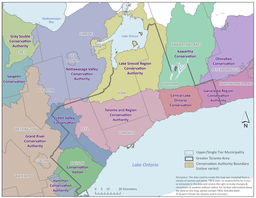
2023 TRCA Flood Contingency Manual

Contents
1.0 Introduction................................................................................................................................................. 4
   Emergency Management and Civil Protection Act ...................................................................................... 4
2.0 Roles and Responsibilities of Agencies ..................................................................................................... 6
   2.1 Municipal Role ........................................................................................................................................ 6
   2.2 Conservation Authority Role .................................................................................................................. 6
   2.3 Provincial Role (Surface Water Monitoring Centre) ............................................................................... 6
   2.4 Interaction of Agencies – Overview........................................................................................................ 7
3.0 Flood Messages ......................................................................................................................................... 8
   3.1 Normal (Green)....................................................................................................................................... 9
   3.2 Watershed Conditions Statement (Yellow) ............................................................................................ 9
   3.3 Flood Watch (Orange) ............................................................................................................................ 9
   3.4 Flood Warning (Red) ............................................................................................................................ 10
   3.5 Lake Ontario and Georgian Bay Shoreline Flood Messages .............................................................. 10
   3.6 Thresholds for Shoreline flood messages............................................................................................ 11
       Table 2: Wind Velocity Descriptions ....................................................................................................... 12
   3.7 Coordinating Issuance of Flood Messages .......................................................................................... 12
4.0 Flood Response Procedures ................................................................................................................... 13
   4.1         Communications and operations related to Municipal Emergency Operations Centres .............. 13
Appendix A: Flood and Weather Terminology ............................................................................................... 15
   A.1         Standardized Description of Flood Magnitude .............................................................................. 15
   A.2         Weather Forecast Terminology and Definitions ............................................................................ 15
       Table A.1: Intensity of rain based on rate of fall ..................................................................................... 16
       Table A.2: Estimating Intensity of Rain .................................................................................................. 16
   A.3         Environment Canada Weather Alert Definitions ........................................................................... 17
Appendix B: Flood Message Definitions and Sample Flood Messages ........................................................ 20
   B.1         Flood Message Terminology Quick Reference ............................................................................. 20
   B.2         Sample Spring Breakup Message ................................................................................................. 22
   B.3         Sample Watershed Conditions Statement – Water Safety ........................................................... 25
   B.4         Sample Watershed Conditions Statement- Flood Outlook ........................................................... 27
   B.5         Sample Flood Watch ..................................................................................................................... 29
   B.6         Sample Flood Warning .................................................................................................................. 32
   B.7 Sample Lake Ontario Shoreline Flood Messages ............................................................................... 34

                                                                                              Toronto and Region Conservation Authority                    |     2
2023 TRCA Flood Contingency Manual

Appendix C: Primary Conservation Authorities Key: ................................................................................... 36
Appendix D: Flood Vulnerable Areas ............................................................................................................. 39
   D.1        Flood Risk Assessment and Mitigation ......................................................................................... 39

                                                                                           The information contained in this document is copyright
                                                                                                    © Toronto and Region Conservation Authority

                                                                                     Toronto and Region Conservation Authority             |     3
2023 TRCA Flood Contingency Manual

1.0 Introduction

The responsibility for dealing with flood contingency planning in Ontario is shared by municipalities,
Conservation Authorities (CAs) and the Ministry of Natural Resources and Forestry (MNRF), on behalf
of the province. As with all emergencies, municipalities have the primary responsibility for the welfare
of residents and should incorporate flood emergency response into municipal emergency planning.
The Ministry of Natural Resources and Forestry and the Conservation Authorities are primarily
responsible for operating a forecasting and warning system, and the province may coordinate a
response in support of municipal action.
The Conservation Authorities of the Greater Toronto Area (GTA) have developed a Flood Forecasting
and Warning program for the municipalities and residents within their collective watersheds and the
shoreline of Lake Ontario and Georgian Bay. The purpose of this service is to reduce risk to life and
damage to property by providing local agencies and the public with notice, information and advice so
that they can respond to potential flooding and flood emergencies.
This Flood Contingency Plan is intended for all public officials and agency staff likely to play a role in
the prevention, mitigation, preparedness, response and recovery pertaining to flood events. This
version of the Flood Contingency Plan provides general information on the Flood Forecasting and
Warning program for each GTA Conservation Authority, as well as specific information and contacts
for municipalities within TRCA’s jurisdiction.
The Conservation Authorities of the Greater Toronto Area include Conservation Halton (HRCA), Credit
Valley Conservation Authority (CVCA), Toronto and Region Conservation Authority (TRCA), Lake
Simcoe Region Conservation Authority (LSRCA), Central Lake Ontario Conservation Authority
(CLOCA), Ganaraska Region Conservation Authority (GRCA), Nottawasaga Valley Conservation
Authority (NVCA) and Kawartha Region Conservation Authority (KRCA). Figure 1 illustrates the
jurisdiction of each GTA Conservation Authority.

Emergency Management and Civil Protection Act

Ontario's Emergency Management and Civil Protection Act (EMCPA, 2006) sets out requirements for
the development, implementation and maintenance of municipal and ministry emergency management
programs. These comprehensive emergency management programs are based on the five principles
of emergency management: prevention, mitigation, preparedness, response, and recovery. The
programs include the development of hazard identification and risk assessment (HIRA) for each of the
56 identified provincial hazards. The province describes six “pillars of preparedness"; each an
essential component of an emergency management program, including:
•   Emergency Plans
•   Emergency Operations Centre
•   Training & Exercises
•   Emergency Information
•   Public Education

                                                              Toronto and Region Conservation Authority   |   4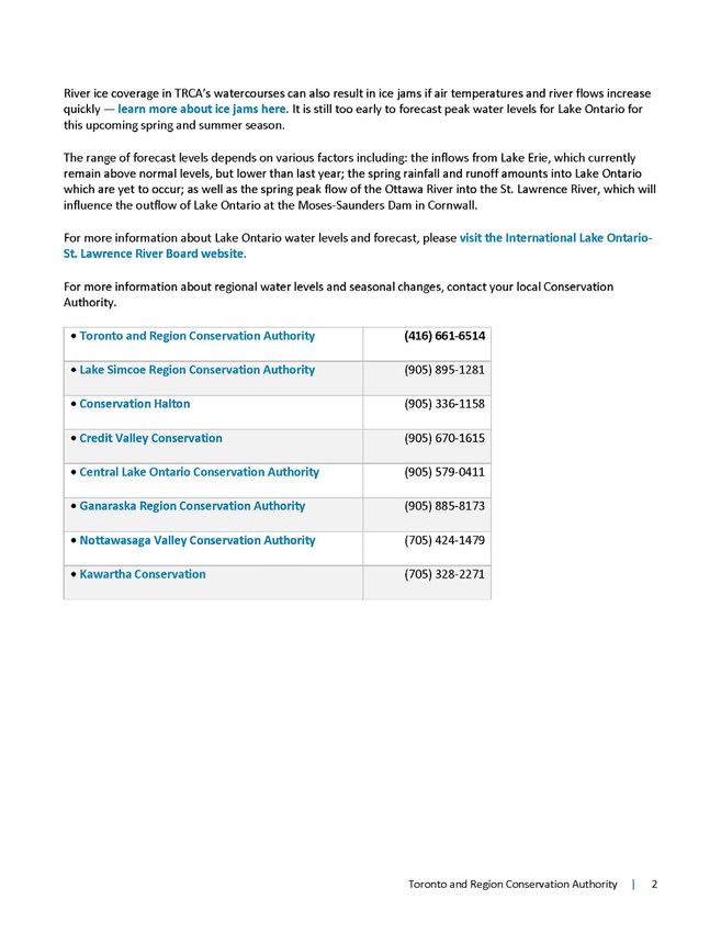
2023 TRCA Flood Contingency Manual

The province has assigned the responsibility of emergency response for flooding to the Ministry of
Natural Resources and Forestry, which includes flood forecasting and warning as well as flood control
operations. Where a Conservation Authority exists, the province relies on the Conservation Authority to
assist them in their assigned responsibilities for flooding.
The TRCA Flood Forecasting and Warning program provides vital service to our municipal partners to
ensure that the flood aspects of these components are met.

          Figure 1: Greater Toronto Area Conservation Authority and Regional Municipalities

                                                           Toronto and Region Conservation Authority   |   5
2023 TRCA Flood Contingency Manual

2.0 Roles and Responsibilities of Agencies

2.1 Municipal Role

Under the Emergency Management and Civil Protection Act (Ontario Regulation 380/04), municipalities
have the primary responsibility and authority for response to flooding and flood emergencies, and also
for the welfare of residents and protection of property. In order to fulfill this responsibility, municipalities
should ensure that emergency plans are kept current and tested on a regular basis. Figure 12 illustrates
the interaction of agencies.
Upon receiving a Flood message, municipalities shall (as appropriate):
        1.      Notify appropriate municipal officials, departments and agencies in accordance with their
                municipal emergency plan.
        2.      Determine the appropriate response to a flood threat and, if warranted, deploy municipal
                resources to protect life and property.
        3.      If required, declare a flood emergency and implement their emergency response plan.
        4.      Request provincial assistance under the Emergency Management and Civil Protection
                Act, if municipal resources are inadequate to respond to the emergency.
        5.      Maintain liaison with Conservation Authority Flood Duty Officers.

2.2 Conservation Authority Role
Conservation Authorities have several areas of responsibility for flooding and flood emergencies, but
act primarily in an advisory capacity to:
        1.      Support municipal flood emergency planning by providing technical advice pertaining to
                flood risk (e.g., hydrology, hydraulics, flood vulnerable areas, etc.) and where applicable,
                engage in flood mitigation projects to reduce flood risk prior to flood events.
        2.      Maintain a local network, collect data, and monitor watershed and weather conditions
                daily in order to provide timely warning of anticipated or actual flood conditions (i.e.,
                operate a flood forecasting and warning system). Provide updated forecasts and other
                supporting technical data pertaining to flood conditions under their jurisdiction during an
                event.
        3.      Issue flood messages to municipalities and other appropriate agencies, including the
                media and the public, to advise of potential flooding when appropriate.
        4.      Operate Conservation Authority dams and flood control structures to reduce the effects
                of flooding when appropriate.
        5.      Maintain communications with municipalities and the MNRF Surface Water Monitoring
                Centre during a flood event.

2.3 Provincial Role (Surface Water Monitoring Centre)
       1.      Operate and maintain a provincial forecasting and warning system to alert MNRF District
               Offices and Conservation Authorities of potential meteorological events that could create
               a flood hazard.
       2.      Maintain communications with MNRF District Offices and Conservation Authorities
               regarding the status of provincial flood potential.

                                                                Toronto and Region Conservation Authority   |   6
2023 TRCA Flood Contingency Manual
3. Receive messages from CAs, MNRF Districts and other agencies and provide analysis
and information that is used to guide the MNRF’s response to a flood.
4. Assists the MNRF Districts where CAs do not exist in the preparation of river response
forecasts, daily planning cycle, and the monitoring of local storm conditions.
2.4 Interaction of Agencies – Overview
Updates
MINISTRY OF NATURAL RESOURCES MINISTRY INTERNAL
AND FORESTRY – SURFACE WATER COMMUNICATION SYSTEM
MONITORING CENTRE
FLOOD
MONITORING &
Provincial FORECASTING
Flood Messages,
Weather and ACTIVITIES
and Updates
Warning System
CONSERVATION AUTHORITY
FLOODING
COMMUNICATIONS
Flood Messages ACTIVITIES
and Updates
MUNICIPALITY
Assistance when Communication in accordance with
situation beyond Municipality’s Emergency Plan (EOC)
local ability to Declaration of Emergency
control FLOOD
EMERGENCY
RESPONSE
ACTIVITIES
PROVINCE
FIGURE 2: INTERACTION OF AGENCIES
Toronto and Region Conservation Authority | 72023 TRCA Flood Contingency Manual
3.0 Flood Messages
A flood is defined as a situation where water levels in a watercourse exceed the channel banks. Each
Conservation Authority operates a flood forecasting and warning program that monitors weather
forecasts and watershed conditions on a continuous basis when conditions warrant. However, a Flood
Duty Officer is accessible 24/7 during all weather and watershed conditions. The weather and
watershed information is used to assess the potential for flooding. When spring melt or severe storms
are anticipated, the Conservation Authority estimates the severity, general location, and approximate
timing of possible flooding, and provides these forecasts to local agencies.
When conditions warrant, Conservation Authorities will communicate with local agencies using one of
the following types of flood messages for river or shoreline based flooding (Appendices A and B
provide additional details):
Conditions Statements, Flood Watch, or Flood Warning.
The standard content of a flood message includes:
• Identification of sender (Conservation Authority and name of Flood Duty Officer)
• The date and time of issuance
• General recipient list
• Summary of weather forecast (expected precipitation, temperature, timing, etc.)
• Description of potential flood magnitude, a general assessment of flooding implications,
identification of potentially unsafe areas, or early notice of the potential for flooding
• Any recommended actions that should be considered by recipients
• Effective dates for the flood message and/or the date and time of next update
• Conservation Authority contact for additional information
Also, the Surface Water Monitoring Centre (SWMC) of the MNRF provides continual weather
monitoring and forecasting, as well as performs a daily (or more frequent if required) provincial flood
hazard identification risk assessment for Ontario as part of their Provincial Warning System. SWMC
will issue a flood message when weather and watershed/shoreline conditions warrant for Ontario. The
SWMC flood messages are distributed to MNRF districts (both districts with and without CAs), MNRF
Internal as well as other key agencies and CAs. SWMC flood messages include information about the
type of message being issued (i.e. Watershed Conditions Statement), the weather situation and
potential risks as well as noting the affected districts, CAs. SWMC flood messages also identify the
flood messages already issued by any of the CAs.
The SWMC also maintains the Provincial Warning System to alert MNRF Districts and Conservation
Authorities of potential meteorological events that could create a flood hazard.
The Flood message levels issued by Conservation Authorities are as follows:
Toronto and Region Conservation Authority | 82023 TRCA Flood Contingency Manual
3.1 Normal (Green)
A “Normal” condition is defined as a general notice that no flooding conditions exist.
3.2 Watershed Conditions Statement (Yellow)
A “Watershed Conditions Statement” is defined as a general notice that potential conditions exist that
pose a risk to personal safety or which have the potential to lead to flooding. Statements are primarily
directed to the public, media and flood coordinators. The message reports on general watershed
conditions and encourages public awareness of increased risk near riverine systems.
There are two variations of this message:
i. Watershed Conditions Statement – Water Safety Statement is issued when high flows,
unsafe banks, melting ice or other factors could be dangerous for recreational users such
as anglers, canoeists, hikers, children, pets, etc. Flooding is not expected.
ii. Watershed Conditions Statement – Flood Outlook Statement is early notice of the
potential for flooding based on weather forecasts calling for heavy rain, snow melt, high
wind or other conditions that could lead to high runoff, cause ice jams, lakeshore flooding
or erosion.
3.3 Flood Watch (Orange)
Toronto and Region Conservation Authority | 92023 TRCA Flood Contingency Manual
A Flood Watch is defined as a notice that flooding is possible in specific watercourses or
municipalities. Municipalities, emergency services and individual landowners in flood-prone areas
should prepare.
A Flood Watch may be updated depending upon weather and runoff conditions, and will be followed
by a notice of cancellation once the potential for flooding has passed.
3.4 Flood Warning (Red)
A Flood Warning is defined as a notice that flooding is imminent or already occurring in specific
watercourses or municipalities. Municipalities and individuals should take action to deal with flood
conditions. This may include road closures and evacuations.
Flood Warnings may be updated depending on weather and runoff conditions, and will be followed by
a notice of cancellation once the potential for flooding has passed.
3.5 Lake Ontario and Georgian Bay Shoreline Flood Messages
Shoreline flood messages are similar in category to river flood messages but are only applicable to
shoreline areas within a Conservation Authority’s jurisdiction. These types of messages also have
three categories and are issued when critical high water levels and waves are either possible or
imminent and/or occurring, which could result in shoreline flooding and/or erosion. These messages
are issued to the municipalities, emergency services as well as the public. Examples of the shoreline
flood message categories are shown below for Lake Ontario.
Specifically for TRCA, areas of the Lake Ontario shoreline fall within its jurisdiction, particularly within
the City of Toronto, City of Pickering and Town of Ajax. Other Conservation Authorities will have
different sections of Lake Ontario as well as Georgian Bay.
Toronto and Region Conservation Authority | 102023 TRCA Flood Contingency Manual
3.6 Thresholds for Shoreline flood messages
The table below outlines the criteria used to determine critical high-water levels and wave heights and
thus shoreline flood messages. Critical water level and wave height thresholds have been added at
Toronto in response to the high lake level events that were experienced in 2017 and 2019. Note that
this criteria is used by and applies to Conservation Authorities adjacent to Lake Ontario or Georgian
Bay. Also, historically this type of warning has not been required for Lake Simcoe.
Table 1: Critical Water Levels and Wave Heights for Lake Ontario & Georgian Bay
Critical Water Levels and Wave Heights for Lake Ontario & Georgian Bay
Critical Water Levels
Section (cm above chart datum, IGLD, Wave height (metres)
1985)
Niagara Region – Stoney Creek 160 cm >1.5 m
Stoney Creek – Burlington 130 cm >2.0 m
Oakville – Port Credit 170 cm >2.0 m
Toronto – Waterfront/Toronto 130 cm (Watch only) >2.0 m (Shoreline
Islands 150 cm (Warning only) Conditions Statement
only)
Whitby – Bowmanville 170 cm >2.0 m
Port Hope 160 cm >2.0 m
Port Hope – Presqu’ile 170 cm >2.0 m
Prince Edward County 170 cm >2.0 m
Georgian Bay – Collingwood / 130 cm >1.0m
Wasaga Beach
Notes:
i. Shoreline flood messages for the Hamilton/Burlington Beachstrip of Lake Ontario are issued
if either critical water levels or wave criteria are met.
ii. Wave criteria apply only when Lake Ontario’s static water level is 90 cm above chart datum,
IGLD 1985.
iii. IGLD (International Great Lakes Datum) is the elevation reference system used to define
water levels within the Great Lakes - St. Lawrence River system because of movement of
the earth’s crust. The reference system is adjusted every 25-35 years.
Toronto and Region Conservation Authority | 112023 TRCA Flood Contingency Manual
Forecasted wind velocities are also used to predict potential shoreline flooding/erosion problems. The
following table displays the various terminologies and units usually used to describe wind velocity.
Table 2: Wind Velocity Descriptions
Wind Velocity Descriptions
kilometres/hour
Wind Speed knots (kts) miles/hour (mph)
(km/h)
Light 1-14 1-16 1-26
Moderate 15-19 17-22 28-35
Strong 20-33 34-47 39-54
Gale 34-47 39-54 63-87
Storm 48-63 55-73 89-117
The following terms are also used when describing wind velocities and their influence on critical wave
heights.
Wind Direction: the direction from which the wind is blowing
Wind Setup: the vertical rise above normal water level on the leeward site of a body of water
caused by wind stresses on the surface of the water
Leeward: the direction toward which the wind is blowing, the direction toward which
waves are traveling
Wave Height: the amplitude measured from wave trough to wave crest, for offshore areas,
outside the breaker line
3.7 Coordinating Issuance of Flood Messages
Conservation Authorities utilize an array of technologies to disseminate flood messages. The GTA
CAs will issue flood messages with various methods such as, but not limited to; a web-based e-mail
service, text messages, Twitter, RSS feed, website technologies and fax. Messages are sent to
designated individuals within municipalities and other local agencies. These individuals, in turn, are
responsible for relaying the message to relevant individuals and departments within their organizations
and activating their role as defined by their organization’s Emergency Response Plan.
Conservation Authority jurisdictions are based on watershed boundaries, not regional or municipal
boundaries. Therefore, in many areas, local governments may be serviced by two or more
Conservation Authorities. To streamline and coordinate communication with local agencies, a primary
Conservation Authority has been assigned for each region and municipality. The remaining CAs within
the municipality are assigned as Secondary CAs for that municipality. Both the primary and secondary
CAs are responsible for issuing flood message (Conditions Statements, Flood Watches, and Flood
Toronto and Region Conservation Authority | 122023 TRCA Flood Contingency Manual
Warnings) directly to the municipality/agency through the established designated contacts. The
messages issued by each conservation authority are specific to the watersheds under their
jurisdiction. During extreme weather events, when resources are stretched, the designated primary CA
for each region and municipality will be responsible for direct communication and will coordinate
incoming information from all relevant CA’s to their primary region/municipality. Please see section 4.1
on the staffing of municipal Emergency Operations Centres.
During most storm events, municipalities, local agencies, and residents requiring information or
assistance should contact the local Conservation Authority having jurisdiction for the area of interest.
Appendix C displays the primary and secondary Conservation Authorities for each municipality in the
GTA.
4.0 Flood Response Procedures
As previously mentioned, during an actual flood event the primary responsibility for the welfare of
residents and protection of property rests with the municipality. Upon receiving a flood message,
municipalities should monitor their local conditions and determine the appropriate action, which may
include activating their Emergency Response Plan.
Where a flood emergency is beyond the capacity of a municipality, provincial assistance can be
requested in accordance with the municipality’s Emergency Response Plan.
Conservation Authorities will provide updated information as well as technical advice on flood
monitoring and where the CA has capacity, flood mitigation to partner municipalities and local
agencies before, during and after a flood event. These actions support our municipal partners and
assist in achieving standardized response goals, which include:
• Provide for the safety and health of responders
• Save lives
• Reduce suffering
• Protect public health
• Protect government infrastructure
• Protect property
• Protect the environment, and
• Reduce economic and social losses
During the emergency, the Conservation Authority representative will continue to advise the MNRF
Surface Water Monitoring Centre of the status of the situation. The Surface Water Monitoring Centre
will be responsible for updating and relaying information related to the emergency to MNRF district
offices.
4.1 Communications and operations related to Municipal Emergency Operations Centres
The Province of Ontario, through its Emergency Management and Civil Protection Act legislation,
requires all municipalities to have valid emergency response plans and procedures in place. One
component of this requirement is the need to have a defined Emergency Operations Centre (EOC)
Toronto and Region Conservation Authority | 132023 TRCA Flood Contingency Manual
where municipal activities can be undertaken in the event of an emergency. Under normal flooding
operations where there is no need to activate the EOC, each GTA Conservation Authority will provide
information as requested by their local municipalities. This section defines how the GTA Conservation
Authorities will operate (e.g., continue to provide advice and information to municipalities) in the case
where EOCs are activated.
The primary Conservation Authority (as defined in Appendix C) will present one or more members of
staff at the EOC (if resources permit). Staff will coordinate flood related information and advice on
behalf of all of the CA’s that service the given local and/or regional Emergency Operations Centre
(EOC/REOC). If multiple municipal emergency operations centres are activated, for which a single CA
is the primary CA, the CA should direct staff to the regional/upper-tier municipal Emergency
Operations Centre for which they are the primary CA.
As several Conservation Authorities may manage watercourses within the jurisdiction of an individual
municipality or region, the primary Conservation Authority staff assigned to attend the EOC/REOC will
be required to provide advice on watersheds which would not be within their normal area of expertise.
To ensure that this system of information coordination and sharing proceeds in a seamless manor, the
following procedures are to be in effect during those occurrences:
1. The primary Conservation Authority will be responsible for coordinating communications
between their assigned local or regional emergency preparedness staff and all other
CA’s with watercourses within the municipal EOC service area. They will discuss the
need to begin the emergency response process and whether a need exists for the
regional/municipal EOC group to assemble. The decision to assemble the Emergency
Control Group is determined by the local or regional emergency preparedness staff and
will be based on the level and degree of flood threat which may be affecting the
municipality and/or region.
2. The primary Conservation Authority will coordinate with secondary Conservation
Authorities to develop and schedule telephone conferences or discussions to ascertain
specific flood related information as well as updated weather forecast information.
3. The secondary Conservation Authorities will consolidate flooding and weather
information into a briefing note which will be forwarded to their representative at the
Regional EOC at the agreed upon designated times (or as required).
4. All GTA Conservation Authorities will ensure that their internal operations
manuals/procedures reflect the requirements outlined above.
To ensure the effectiveness of the above procedure, each GTA CA will develop a working relationship
with the emergency management offices of each of their municipal/regional partners.
Toronto and Region Conservation Authority | 142023 TRCA Flood Contingency Manual
Appendix A: Flood and Weather Terminology
A.1 Standardized Description of Flood Magnitude
In order to improve the understanding of flood messages sent by the various Conservation Authorities,
Flood Watches and Flood Warnings may include the following terminology to describe the magnitude
of anticipated flooding. Note that response actions such as evacuations are determined by the
municipality.
No Flooding: Water levels remain within channel banks.
Nuisance Flooding: Flooding of low-lying lands. However, road access remains available and no
structures will be flooded.
Minor Flooding: Potential for some structural flooding and sections of road access may be
impassable. Evacuations are not anticipated.
Major Flooding: Potential for significant basement flooding, some first floor flooding, and
significant road access cuts. Evacuation possibly required.
Severe Flooding: Potential for many structures to be flooded, major disruption of roads and services.
Evacuations are expected due to risk to life and major damages to residential,
industrial, commercial and/or agricultural sites. The event may produce negative
environmental impacts caused by spills of hazardous substances such as sewage,
oils, chemicals, etc., that pose a threat to public safety and/ or to the eco-system.
A.2 Weather Forecast Terminology and Definitions
A key component of a Conservation Authority’s flood forecasting and warning system is the ability to
interpret weather forecasts. Definitions of the most commonly used weather forecasting terms related
to precipitation are provided below, as per Environment Canada definitions.
When issuing a flood message to our partner municipalities and local agencies, the Flood Duty Officer
who issues the flood message cannot reasonably expect the receivers of the flood message to
remember all severe weather terminology or expect the client to locate these definitions quickly in an
emergency situation. Therefore, it is important to use enough detail in the flood messages to make any
technical terms self-explanatory. For example, the term “heavy rainfall” should be accompanied by the
estimated quantity as well as the estimated duration (i.e.50mm of rain over the next 12 hours). A
sufficient number of qualifiers should be used to make the message clear to the intended reader.
Terms such as drizzle, rain, or snow are used to indicate the occurrence of precipitation. The various
forms of precipitation are defined as follows:
Drizzle: Fairly uniform precipitation composed exclusively of fine drops with diameters of
less than 0.5 mm, falling very close together. Drizzle appears to flow while
following air currents.
Rain: Precipitation, in the form of drops larger than 0.5 mm.
Snow: Precipitation of snow crystals, predominantly in the form of six-pointed stars.
Toronto and Region Conservation Authority | 152023 TRCA Flood Contingency Manual
These terms may be accompanied by qualifying words and numbers to provide further detail regarding
the intensity, amount and proximity of the precipitation. Qualifiers may be used in various
combinations to describe weather phenomena.
The intensity qualifiers that are used are: light, moderate, or heavy, in accordance with the following
charts.
Table A.1: Intensity of rain based on rate of fall
Intensity of rain based on rate of fall
Intensity Criteria
Light Up to 2.5 mm per hour; maximum 0.25 mm in 6 minutes.
Moderate 2.6 mm to 7.5 mm per hour; more than 0.75 mm in 6 minutes.
Heavy More than 7.6 mm per hour; more than 0.75 mm in 6 minutes.
Table A.2: Estimating Intensity of Rain
Estimating Intensity of Rain
Intensity Criteria
Light From scattered drops that, regardless of duration, do not completely
wet an exposed surface, up to a condition where individual drops are
easily seen.
Moderate Individual drops are not clearly identifiable; spray is observable just
above pavements and other hard surfaces.
Heavy Rain seemingly falls in sheets; individual drops are not identifiable;
heavy spray to heights of several inches is observed over hard
surfaces.
It is often difficult to accurately forecast the amount of rain expected, due to the subjective nature of
computer model interpretation, and the large areas for which computer models are applied.
The actual amounts of precipitation received are dependent on how the weather system reacts to the
conditions and topography as it crosses a specific location. The presence of water bodies in particular
will cause the weather to differ over relatively short distances.
For example, when a forecaster predicts that “south central Ontario will receive 25 mm today”, this does
not mean that a specific area will receive exactly 25 mm, or even a maximum quantity of 25 mm. What
this does mean is that, generally, over the area of south central Ontario, 25 mm are likely to fall over a
location provided that current conditions remain the same.
Toronto and Region Conservation Authority | 162023 TRCA Flood Contingency Manual
When a range is given, such as 10-20 mm, this implies a degree of uncertainty on the part of the
forecasters with respect to the exact tracking of a system. The various computer models used may not
be in agreement with regards to the estimated rainfall. Therefore, the forecaster is covering each
possibility by using a range.
The terms showers and thunderstorms are used to further qualify the type of precipitation and weather
phenomena that are expected.
Showers: Precipitation that stops and starts again abruptly, changes intensity rapidly, and
is usually accompanied by rapid changes in the appearance of the sky.
Thunderstorm: A local storm produced by cumulonimbus clouds and is accompanied by lightning
and/or thunder. Thunderstorms are essentially overgrown showers that produce
thunder and lightning.
The probability of precipitation is another qualifier frequently used in forecasts. The probability of
precipitation represents the likelihood of the occurrence of measurable precipitation at any point in the
region. Thus, a probability of 30 per cent means that out of 100 similar situations, precipitation should
occur 30 times.
Rain, snow, periods of rain, or intermittent rain or snow will normally appear with probabilities of 90 or
100 per cent, and indicate that a major weather system will affect the region. The amount of precipitation
may vary.
The terms showers, flurries or occasional rain (or snow) imply that the precipitation will not be continuous,
and any point in the region is likely to get a measurable amount. These terms are normally combined
with probabilities in the 60 to 80 per cent range.
The term scattered is used to qualify the terms showers and flurries when only a portion of the region is
expected to get measurable precipitation. The probabilities associated with scattered showers are in the
30 to 50 per cent range.
When isolated thunderstorms are forecast, a probability of precipitation of 10 or 20 per cent is normally
applied. Only a small part of the region is likely to get rain, but those areas that do are likely to get
intense heavy rain for short periods. Thunderstorms may occur during a continuous rain (i.e., embedded
thunderstorms). Hail, strong winds, and even tornadoes can result from severe thunderstorms.
A.3 Environment Canada Weather Alert Definitions
This section describes the severe weather terminology used by the Meteorological Service of Canada,
a department of Environment Canada. Environment Canada’s Ontario Storm Prediction Centre (OSPC)
also utilizes these severe weather terminologies.
OSPC issues severe weather alerts as a watch or a warning, depending on the risk or severity of the
event. Less severe events that could be a cause for concern will be issued as a special weather
statement or Advisory. Updated statements, watches, and warnings are re-issued or upgraded if
required.
Toronto and Region Conservation Authority | 172023 TRCA Flood Contingency Manual
Rainfall Warning
The OSPC strive to issue a Rainfall Warning for synoptic rainfall events (from larger scale weather
systems) 12 hours in advance of the event reaching the affected areas. For convective rainfall events
(smaller or mesoscale convective weather systems), OSPC strive to issue a Rainfall Warning 2 hours
in advance of the event reaching the affected area(s).
The following are when OSPC issues rainfall warnings:
Short Duration: 50 mm or more of rain expected within 1 hour (similar to Severe Thunderstorm
Warning but where no thunder is present or expected)
General Summer Case: I) 50 mm or more of rain expected to fall within 24 hours.
ii) 75 mm or more of rain expected to fall within 48 hours
Winter (Saturated or Frozen Ground): 25 mm or more of rain expected to fall within 24 hours.
Note: The 25 mm criterion for winter conditions is generally discussed with the MNRF Surface Water
Monitoring Centre before OSPC issues a warning (for consistency).
Thunderstorm Potential
Issued in Ontario only, these statements are issued twice daily (4:00am and 4:30pm) from May through
September. These statements give an in-depth description of severe thunderstorm potential for the next
48 to 60 hours.
The 4:00am Thunderstorm Potential statement covers severe thunderstorm potential for:
• today,
• tonight, and,
• tomorrow.
The 4:30pm Thunderstorm Potential statement covers severe thunderstorm potential for:
• tonight,
• tomorrow, and,
• the following day.
Summer Severe Weather – Local-scale
Due to its local-scale nature, a watch is typically issued in advance for public forecast areas where
conditions may be favourable for the development of severe weather. A warning is issued for areas
where severe weather is imminent or occurring. Unlike other warnings, these are issued for smaller
warning areas within its regular forecast region.
Severe Thunderstorm Watch – Issued when the potential exists (within 6 hours) for the
development of severe thunderstorms, which are capable of producing one or more of the following:
• Large hail (2cm or more in diameter)
• Damaging winds (Gusts 90 km/h or greater)
• Heavy rain: 50mm or more per hour.
Toronto and Region Conservation Authority | 182023 TRCA Flood Contingency Manual
• There is also an occasionally used heavy rain criterion of 75mm in 3 hours or less (as
mentioned in the Thunderstorm Potential Bulletin).
Severe Thunderstorm Warning – Issued when a severe thunderstorm is detected on radar or are
observed by those in the immediate area or is expected to move into an affected area in the next 30
minutes. A warning is issued when one or more of the following has been detected or highly possible:
• Large hail (2 cm or more in diameter)
• Damaging winds (Gusts 90 km/h or greater)
• Heavy rain: 50mm or more per hour.
Toronto and Region Conservation Authority | 192023 TRCA Flood Contingency Manual
Appendix B: Flood Message Definitions and Sample Flood Messages
B.1 Flood Message Terminology Quick Reference
TRCA issues three types of messages:
A flood is defined as a situation where water levels in a watercourse exceed the channel banks. Each
Conservation Authority operates a 24-hour flood forecasting and warning program that monitors
weather forecasts and watershed conditions. This information used to assess the potential for flooding.
When spring melt or severe storms are anticipated, the Conservation Authority estimates the severity,
location and timing of possible flooding and provides these forecasts to local agencies.
When conditions warrant, Conservation Authorities will communicate with local agencies using one of
the following types of flood messages (Appendices A and B provide attentional details): Watershed
Conditions Statements, Flood Warning or Flood Watch.
• The standard content of a flood message includes:
• The date and time of issuance
• Identification of sending (Conservation Authority and name of Flood Duty Officer)
• General recipient list
• Summary of weather forecast (expected precipitation, temperature, timing, etc)
• Description of potential flood magnitude, a general assessment of flooding implications,
identification of potentially unsafe areas or early notice of the potential for flooding
• Date and time of next update
• Conservation Authority contact for additional information
A “Normal” condition is defined as a general notice that no
flooding conditions exist.
Watershed Conditions Statements
A “Watershed Conditions Statement” is defined as a general notice that potential conditions exist that
pose a risk to personal safety or which have the potential to lead to flooding. Statements are primarily
directed to the public, media and flood coordinators. The message reports on general watershed
conditions and encourages public awareness of increased risk near riverine systems.
There are two variations of this message:
Watershed Conditions Statement – Water Safety Statement is
issued when high flows, unsafe banks, melting ice or other factors could be dangerous for recreational
users such as anglers, canoeists, hikers, children, pets, etc. Flooding is not expected.
Toronto and Region Conservation Authority | 202023 TRCA Flood Contingency Manual
Watershed Conditions Statement – Flood Outlook Statement is
early notice of the potential for flooding based on weather forecasts calling for heavy rain, snow melt,
high wind or other conditions that could lead to high runoff, cause ice jams, lakeshore flooding or erosion.
Flood Watch
A Flood Watch is defined as a notice that flooding is possible in
specific watercourses or municipalities. Municipalities, emergency services and individual landowners
in flood-prone areas should prepare.
A Flood Watch may be updated depending upon weather and runoff conditions, and will be followed
by a notice of cancellation once the potential for flooding has passed.
Flood Warning
A Flood Warning is defined as a notice that flooding is imminent
or already occurring in specific watercourses or municipalities. Municipalities and individuals should
take action to deal with flood conditions. This may include road closures and evacuations.
Lake Ontario and Georgian Bay Shoreline Flood Messages
Shoreline messages are similar in category to the riverine flood messages, however, are only
applicable to a specific waterbody shoreline within a CA’s jurisdiction. They are issued when critical
high-water levels and waves are forecasted, imminent or occurring, which could result in shoreline
flooding and/or erosion. These types of messages are issued to municipalities and emergency
services, regardless of whether or not they reside or operate along the shoreline.
Toronto and Region Conservation Authority | 212023 TRCA Flood Contingency Manual
B.2 Sample Spring Breakup Message
Toronto and Region Conservation Authority | 222023 TRCA Flood Contingency Manual
Toronto and Region Conservation Authority | 232023 TRCA Flood Contingency Manual
Toronto and Region Conservation Authority | 242023 TRCA Flood Contingency Manual
B.3 Sample Watershed Conditions Statement – Water Safety
WATERSHED CONDITIONS STATEMENT
WATER SAFETY
DATE: FRIDAY MARCH 18TH, 2022
TIME: 3:30 PM
ISSUED TO: SCHOOL BOARDS, MUNICIPALITIES, LOCAL CONSERVATION AUTHORITIES, LOCAL POLICE,
EMERGENCY SERVICES AND MEDIA
Weather Conditions:
Toronto and Region Conservation Authority advises that Environment Canada is forecasting a weather
system that may bring 10-20mm of precipitation to the Greater Toronto Area from Friday to Sunday.
The rain is expected to begin late Friday night, continue throughout the day on Saturday, and taper off
Sunday morning. There is a marginal risk for thunderstorms to develop which may bring an additional
5mm of rain, however these storms are not expected to be intense and are not expected to linger in
any one location.
Issues:
Due to the total rainfall expected, all rivers within the GTA may experience higher flows and water
levels. Furthermore, there are areas within the GTA that still have snow cover which, when combined
with mild temperatures and precipitation, can contribute to increased runoff. The combination of
slippery and unstable banks, and rising water levels could create hazardous conditions near rivers or
other water bodies.
There has also been observed a continued presence of ice coverage through the upper reaches of the
Humber River. The combination of warm weather and precipitation increases the potential for this ice
coverage to break up and migrate downstream. As such, localized ponding is possible in low-lying
areas which may be worsened by backwater effects in areas prone to ice jamming.
Actions:
Avoid all recreational activities in or around water at this time and please exercise caution if you must
be around any bodies of water, rivers or streams as well as the Lake Ontario shoreline. Avoid areas
already experiencing erosion. Please alert any children under your care of these dangers and
supervise their activities. Please keep children and pets away from banks as they may be slippery and
unstable.
Toronto and Region Conservation Authority | 252023 TRCA Flood Contingency Manual
This Water Safety Watershed Conditions Statement will be in effect through to the end of Sunday,
March 20, 2022. To report a flooding incident from a watercourse, please leave a message on
TRCA's floodline listed below. If you are in danger, call 911 immediately.
Flood Duty Officer Chief Flood Duty Officer
Previous Flood Messages issued for the same storm event:
1. No previous flood message issued for the same storm event.
Note: A Water Safety Watershed Conditions Statement may be issued when there are high flows,
unsafe banks, melting ice or other factors could be dangerous for recreational users such as anglers,
canoeists, hikers, children, pets, etc.
Flooding is not expected.
The Flood Forecasting and Warning messages provided through this distribution list are provided as a courtesy, on an as-is
basis, without warranty of any kind. Data or information may contain errors or be incomplete. TRCA does not guarantee
delivery of Flood Forecasting and Warning messages to individuals subscribing through this list. TRCA shall not be liable for
any claim for any loss, harm, illness, or other damage or injury arising from access to or use of TRCA Flood Forecasting and
Warning Messages.
Follow Us: @TRCA_Flood
Learn More: TRCA.ca/Flood
Real-Time Flood Monitoring: TRCAGauging.ca
Toronto and Region Conservation Authority | 262023 TRCA Flood Contingency Manual
B.4 Sample Watershed Conditions Statement- Flood Outlook
WATERSHED CONDITIONS STATEMENT
FLOOD OUTLOOK
DATE: AUGUST 17, 2022
TIME: 2:05 PM
ISSUED TO: SCHOOL BOARDS, MUNICIPALITIES, LOCAL CONSERVATION AUTHORITIES, LOCAL POLICE,
EMERGENCY SERVICES AND MEDIA
Weather Conditions:
Toronto and Region Conservation Authority advises that Environment Canada has issued a severe
thunderstorm warning for Mississauga and Brampton which could deliver 50 mm of rain in an hour.
Training thunderstorms have also been forecast for all areas within the GTA. Thunderstorm cells have
been observed along the Hwy 407/401 corridor. The thunderstorms could deliver as much as 20 to 30
mm of rain fall in less than an hour in a given location. Given the risk of multiple thunderstorm cells
forming over the same area in the afternoon and evening hours today, there is a possibility of rainfall
amounts reaching 50 mm within an hour.
There is also a similar risk for thunderstorms on Thursday afternoon and evening.
Issues:
Due to the total rainfall expected, all rivers within the GTA may experience higher flows and water
levels. Conditions along watercourses may change rapidly due to heavy downpours in a short amount
of time. The combination of slippery and unstable banks, and rising water levels could create
hazardous conditions near rivers or other water bodies. Heavy rainfall from thunderstorms could result
in poor visibility and ponding of water in low lying areas or areas with poor drainage.
Actions:
Avoid all recreational activities in or around water at this time and please exercise caution if you must
be around any bodies of water, rivers or streams as well as the Lake Ontario shoreline. Avoid areas
already experiencing erosion or blockages with debris. Please alert any children under your care of
these dangers and supervise their activities. Please keep children and pets away from banks as they
may be slippery and unstable.
Toronto and Region Conservation Authority | 272023 TRCA Flood Contingency Manual
This Flood Outlook Watershed Conditions Statement will be in effect through to the morning of Friday,
August 19, 2022. To report a flooding incident from a watercourse, please leave a message on
TRCA's floodline listed below. If you are in danger, call 911 immediately.
Flood Duty Officer Chief Flood Duty Officer
Previous Flood Messages issued for the same storm event:
2. No previous flood message issued for the same storm event.
Note: A Flood Outlook Watershed Conditions Statement is an early notice of the potential for flooding
based on weather forecasts calling for heavy rain, snow melt, high wind or other conditions that could
lead to high runoff, cause ice jams, lakeshore flooding or erosion.
The Flood Forecasting and Warning messages provided through this distribution list are provided as a courtesy, on an as-is
basis, without warranty of any kind. Data or information may contain errors or be incomplete. TRCA does not guarantee
delivery of Flood Forecasting and Warning messages to individuals subscribing through this list. TRCA shall not be liable for
any claim for any loss, harm, illness, or other damage or injury arising from access to or use of TRCA Flood Forecasting and
Warning Messages.
Follow Us: @TRCA_Flood
Learn More: TRCA.ca/Flood
Real-Time Flood Monitoring: TRCAGauging.ca
Toronto and Region Conservation Authority | 282023 TRCA Flood Contingency Manual
B.5 Sample Flood Watch
FLOOD WATCH
DATE: FEBRUARY 21, 2022
TIME: 3:00 PM
ISSUED TO: SCHOOL BOARDS, MUNICIPALITIES, LOCAL CONSERVATION AUTHORITIES, LOCAL POLICE,
EMERGENCY SERVICES AND MEDIA
Weather Conditions:
Toronto and Region Conservation Authority advises that Environment Canada is forecasting a
significant weather system that is expected to pass through our jurisdiction Tuesday.
Temperatures above freezing, possibly 10 degrees Celsius or more, and rainfall amounts in the
range of 15-25 mm are forecast Tuesday with the heaviest rainfall anticipated between 8am and
9pm. Some freezing rain is possible Tuesday morning in the northern parts of TRCA’s jurisdiction and
any ice accumulation from freezing rain is expected to melt later the same day. Drizzle may persist
into Tuesday evening ending around midnight. Temperatures are then forecast to drop below
freezing Tuesday overnight and Wednesday.
Water levels throughout TRCA’s watersheds have receded following last week’s event and are at or
near normal levels, with the exception of areas experiencing ice jams, in particular, the Humber River
near Old Mill Road in Toronto where water levels continue to be elevated due to an ice jam in this
location.
Issues:
Toronto and Region Conservation Authority advises that river levels are expected to rise as a result
of this weather system and will cause further break-up and movement of river ice, as well as the
movement of existing ice jams. River water levels and ice jam conditions and locations can
change very rapidly.
With the combination of increased runoff from rainfall on frozen ground as well as snow and ice melt,
water levels and flows in rivers will be higher than normal this week with the incoming weather
system. All rivers and streams within the GTA should be considered dangerous as the weather
conditions will result in higher water levels, fast flowing cold water and slippery or unstable banks.
These conditions are favourable for the breakage and movement of river ice along watercourses and
may cause ice jams and flooding in low‐lying areas. Ice jams can occur anywhere within a river
system but most typically occur in areas near culverts, bridges, and bends in the river. There may
also be potential for jamming at river mouths where the harbour is partially or completely frozen.
Toronto and Region Conservation Authority | 292023 TRCA Flood Contingency Manual
Ice jams have been observed in the following locations as of February 18, 2022:
• City of Toronto
o Mimico Creek – Bloor Street West crossing (southeast corner of Islington Avenue and
Bloor Street West intersection)
o Humber River – Bloor Street crossing as well as near the Toronto Humber Yacht Club
and the Old Mill Road bridge
o Lower Don – Villiers Street to Cherry Street bridge
• City of Brampton
o Etobicoke Creek – Clarence Street bridge
• City of Vaughan
o Humber River – Rutherford Road, east of Highway 27 as well as between Major
Mackenzie and Broda Drive, west of Highway 27
• Town of Caledon (Bolton)
o Humber River – along Glasgow Road to Hickman Street. Additionally there are large
broken-up ice sheets at the Humberlea Rd and King St crossings.
• Town of Ajax
o Duffins Creek – Highway 401 and Bayly Street between Church Street and Westney
Road South
These ice jams formed last Thursday and Friday, in response to last week’s rain and snowmelt event
and may shift in response to tomorrow’s rain and snowmelt event. New ice jams may form in other
locations.
Flooding is possible in low lying areas due to increase runoff from rain and snow melt. Flooding is
possible if high river flows interact with existing ice jams, or if new ice jams form or existing ice jam
breakup and form new jams elsewhere. River water levels and ice jam conditions and locations
can change very rapidly.
Actions:
Please carefully monitor your local conditions. The public is urged to stay away from streams, rivers,
shoreline areas and ice covered areas. Avoid any areas currently experiencing an ice jam and stay
away from large river ice blocks that may be present along river banks. Please exercise caution
around all watercourse crossing structures such as bridges, culverts and dams as well as around all
bodies of water and valley banks. Please alert children in your care of these dangers and supervise
their activities. Avoid areas that may be experiencing flooding or erosion.
TRCA will continue to closely monitor this system and will issue an update or cancellation to this
Flood Watch by 11:30 PM on Wednesday February 23, 2022. To report a flooding incident from a
watercourse, please leave a message on TRCA's floodline listed below. If you are in danger, call
911 immediately.
Flood Duty Officer Chief Flood Duty Officer
Toronto and Region Conservation Authority | 302023 TRCA Flood Contingency Manual
Previous Flood Messages issued for the same storm event:
3. None for this event.
Note: A Flood Watch is a notice that flooding is possible in specific watercourses or municipalities
(due to stream conditions and expected weather). Municipalities, emergency services and individual
landowners in flood-prone areas should prepare.
The Flood Forecasting and Warning messages provided through this distribution list are provided as a courtesy, on an as-is
basis, without warranty of any kind. Data or information may contain errors or be incomplete. TRCA does not guarantee
delivery of Flood Forecasting and Warning messages to individuals subscribing through this list. TRCA shall not be liable for
any claim for any loss, harm, illness, or other damage or injury arising from access to or use of TRCA Flood Forecasting and
Warning Messages.
Follow Us: @TRCA_Flood
Learn More: TRCA.ca/Flood
Real-Time Flood Monitoring: TRCAGauging.ca
Toronto and Region Conservation Authority | 31You can also read