Union Valley Reservoir Boating Management Plan - Sacramento Municipal Utility District Hydro License Implementation October 2016 Upper American ...
←
→
Page content transcription
If your browser does not render page correctly, please read the page content below

Union Valley Reservoir Boating
Management Plan
Sacramento Municipal Utility District
Hydro License Implementation • October 2016
Upper American River Project
FERC Project No. 2101

Union Valley Reservoir Boating Management Plan
                                                                                              October 2016

                                        This page intentionally left blank.

Sacramento Municipal Utility District
Upper American River Project
FERC Project No. 2101
Union Valley Reservoir Boating Management Plan
                                                                                                   October 2016

TABLE OF CONTENTS

1.0     INTRODUCTION .................................................................................................. 1

2.0     METHODS............................................................................................................ 4
        2.1      Existing Information ................................................................................... 4
        2.2      Key Contact Interviews .............................................................................. 4
        2.3      Geographic Information System Map......................................................... 5
        2.4      Consultation ............................................................................................... 5

3.0     EXISTING BOATING CONDITIONS .................................................................... 5
        3.1      Boating Facilities ........................................................................................ 6
                 3.1.1 Sunset Boat Launch ........................................................................ 6
                 3.1.2 Yellowjacket Boat Launch ............................................................... 6
                 3.1.3 West Point Boat Launch .................................................................. 6
        3.2      Reservoir Levels ........................................................................................ 6
        3.3      Boat Density .............................................................................................. 8
        3.4      Interviews ................................................................................................. 10
        3.5      Navigational Hazards ............................................................................... 11
        3.6      Boating Accidents and User Conflicts ...................................................... 12
        3.7      Boating and Wildlife ................................................................................. 14
        3.8      Jurisdiction for Water Surface Management ............................................ 15
                 3.8.1 SMUD ........................................................................................... 15
                 3.8.2 Eldorado National Forest .............................................................. 16
                 3.8.3 State of California.......................................................................... 16
                 3.8.4 El Dorado County Sheriff .............................................................. 16
        3.9      Union Valley Reservoir Management Plan Map ...................................... 18

4.0     WATER SURFACE MANAGEMENT .................................................................. 18
        4.1      Designated Swimming Area at Fashoda Day Use Area .......................... 18
        4.2      Buoys near Project Infrastructure ............................................................ 18
        4.3      Areas with Discretionary Boating Speed Limits ....................................... 18

Sacramento Municipal Utility District
Upper American River Project                                                                                                   i
FERC Project No. 2101
Union Valley Reservoir Boating Management Plan
                                                                                                   October 2016

        4.4      No Boating near Dam .............................................................................. 19
        4.5      Signage.................................................................................................... 19
        4.6      Coordination with El Dorado County Sheriff............................................. 19

5.0     PLAN IMPLEMENTATION ................................................................................. 20
        5.1      Buoys and Signage .................................................................................. 20
        5.2      Operation and Maintenance..................................................................... 20
        5.3      Monitoring and Plan Revision .................................................................. 20

6.0     REFERENCES ................................................................................................... 21

Sacramento Municipal Utility District
Upper American River Project                                                                                                 ii
FERC Project No. 2101
Union Valley Reservoir Boating Management Plan
                                                                                                October 2016

TABLES

Table 3.2-1.      Lake levels and reservoir surface area. .................................................. 7
Table 3.3-1.      Peak boating use on Union Valley Reservoir. ......................................... 8
Table 3.3-2.      Sample observations of boats on Union Valley Reservoir and parking
                  area occupancy. ...................................................................................... 9
Table 4.1-1.      Signs at boat launches. ......................................................................... 19

FIGURES

Figure 1.0-1.     UARP reservoirs in the Crystal Basin. ..................................................... 2
Figure 1.0-2.     Recreational facilities at Union Valley Reservoir. .................................... 3
Figure 3.2-1.     Union Valley Reservoir elevation, surface area, and storage curve. ....... 7
Figure 3.5-1.     Google Earth images of peninsula near Wolf Point Campground at
                  different water levels. ............................................................................ 13

Sacramento Municipal Utility District
Upper American River Project                                                                                            iii
FERC Project No. 2101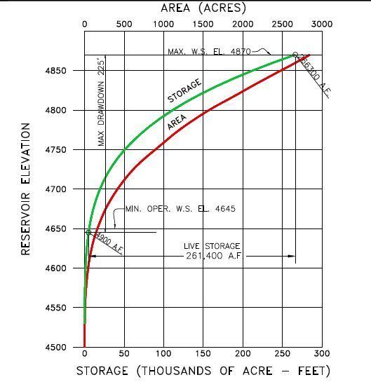
Union Valley Reservoir Boating Management Plan
                                                                                      October 2016

APPENDICES

Appendix A—Union Valley Reservoir Boating Management Plan Map

Appendix B—Union Valley Boating Plan Interviews

ACRONYMS AND ABBREVIATIONS

Cal Boating              California State Parks, Division of Boating and Waterways

ENF                      Eldorado National Forest

FERC                     Federal Energy Regulatory Commission

Forest Service           United States Department of Agriculture, Forest Service

GIS                      geographic information system

License                  FERC License for the Upper American River Project

mph                      miles per hour

msl                      mean sea level

Plan                     Union Valley Reservoir Boating Management Plan

Project                  Upper American River Project (FERC Project No. 2101) or UARP

reservoir                Union Valley Reservoir

SMUD                     Sacramento Municipal Utility District or Licensee

UARP                     Upper American River Project (FERC Project No. 2101) or Project

Sacramento Municipal Utility District
Upper American River Project                                                                    iv
FERC Project No. 2101
Union Valley Reservoir Boating Management Plan
October 2016
1.0 INTRODUCTION
Union Valley Reservoir (reservoir) is a water storage reservoir that is part of the
Sacramento Municipal Utility District (SMUD) system for operating the Upper American
River Project (UARP or Project), Federal Energy Regulatory Commission (FERC)
Project No. 2101. Union Valley Reservoir is located in the Crystal Basin near Ice House
and Loon Lake Reservoirs on Silver Creek, a tributary of the South Fork of the
American River (Figures 1.0-1 and 1.0-2).
The reservoir’s water elevation ranges from a maximum of 4,870 feet mean sea level
(msl) at full pool (2,850 surface acres) down to the Project’s winter pool elevation of
about 4,820 feet msl. Union Valley Reservoir is entirely within the FERC Project
boundary, which provides a minimum horizontal distance from the high-water edge of
about 200 feet. The majority of the shoreline is steep with a few submerged shallow
areas or areas with rocky outcroppings. However, the inlets of the lake are relatively
shallow, including the area from Yellowjacket Boat Launch to Robbs Powerhouse and
the cove west of Camino Campground. Submerged obstacles, such as rocky
outcroppings, and large areas of shallow water may pose hazards to boaters at low
water levels in these areas.
The Project License, issued by FERC on July 23, 2014 (License), incorporates
conditions that are consistent with a Settlement Agreement between SMUD and
stakeholders (FERC 2014). U.S. Forest Service (Forest Service) 4(e) condition no. 45
(see Appendix B of the License) requires SMUD to develop a Union Valley Reservoir
Boating Management Plan (Plan). The Plan is required to address reservoir surface
hazards including user conflicts between differing types of watercraft, human and
wildlife conflicts, marking or removal of manmade underwater hazards, speed limits,
and the need for marker buoys.
The purpose of the Plan is to formulate a policy for managing boating use on the
reservoir and providing public access to Union Valley Reservoir in a manner that: 1) is
consistent with the Project’s primary purpose of power generation; 2) balances present
and future boating use with the need to provide a safe, enjoyable, and environmentally
sensitive recreation experience; and 3) considers SMUD’s scope of authority relative to
reservoir surface management. Upon Eldorado National Forest (ENF) approval of the
plan, SMUD will submit the plan to FERC for approval and will begin implementing plan
measures as soon as the plan is approved by FERC.
Sacramento Municipal Utility District
Upper American River Project 1
FERC Project No. 2101Union Valley Reservoir Boating Management Plan
October 2016
Figure 1.0-1. UARP reservoirs in the Crystal Basin.
Sacramento Municipal Utility District
Upper American River Project 2
FERC Project No. 2101Union Valley Reservoir Boating Management Plan
October 2016
Source: SMUD (2004a)
Figure 1.0-2. Recreational facilities at Union Valley Reservoir.
Sacramento Municipal Utility District
Upper American River Project 3
FERC Project No. 2101Union Valley Reservoir Boating Management Plan
October 2016
The scope of this Plan includes water surface boating use on Union Valley Reservoir
and does not include existing and future recreation facilities that support reservoir
boating use (e.g., boat launch parking areas). Recreation facility needs, as they relate to
reservoir boating use, such as additional or modified facilities, will be assessed every 6
years in the Report on Recreational Resources required by Forest Service 4(e)
condition no. 42, Recreation Survey, and consultation required by Forest Service
condition no. 44, Review of Recreation Developments.
2.0 METHODS
To develop the Plan, SMUD characterized existing conditions at the reservoir by using
three types of information: 1) existing boating conditions, existing regulations, and
information about recreation use patterns at the reservoir; 2) interview responses of
agency and recreation concessionaire staff knowledgeable about boating use at the
reservoir; and 3) a Geographic Information System (GIS) map that summarizes
information relating to the water surface. SMUD circulated a draft of the Plan to the
UARP Consultation Group and revised the draft Plan to address comments, as
appropriate.
2.1 Existing Information
SMUD reviewed existing documented information to characterize boating laws and
management, known recreation use and issues, capacity issues, and known areas of
boat congestion on the lake. The documents included the License application,
recreation studies, El Dorado County ordinances, California boating laws, GIS maps of
low water levels identifying hazards in the water, and Google Earth images of the
reservoir during the summer dating back to 1993.
2.2 Key Contact Interviews
SMUD conducted interviews with key contacts from SMUD, the El Dorado County
Sheriff’s office (boat patrol), the California State Parks, Division of Boating and
Waterways (Cal Boating), California Department of Fish and Wildlife, and ENF. The
discussions were open-ended and focused on the staff’s areas of expertise, but all
interviews included the following questions:
1. Are there boating-related conflicts on the reservoir? If so, please characterize the
conflicts (e.g., excessive speed, collisions with submerged objects, crowding,
conflicts with non-motorized boating, and conflicts between boaters and
swimmers).
2. Are there boating-related conflicts at the boat ramps?
Sacramento Municipal Utility District
Upper American River Project 4
FERC Project No. 2101Union Valley Reservoir Boating Management Plan
October 2016
3. Are there manmade objects in the reservoir that interfere with boating? If so,
where?
4. Are there boating hazards in the reservoir that you believe should be marked? If
so, where?
5. Are there areas of the reservoir where you think speed limits should be
implemented?
6. Are there conflicts between boating activities and wildlife? Please characterize
and identify where conflicts occur (e.g., encounters with bears, harassing deer,
chasing waterfowl, and recreation near raptor/eagle nests).
2.3 Geographic Information System Map
SMUD compiled a GIS map in the plan to depict:
• spatial information collected during the interviews and review of existing
information;
• land features that become exposed as the reservoir lowers;
• areas with user conflicts; and
• locations of existing Project infrastructure, developed recreation sites, buoys, and
boat launches.
2.4 Consultation
On February 4, 2016, SMUD provided a draft of this Plan to the UARP Consultation
Group for a 30-day review and comment period. SMUD received comments from ENF,
the State Water Resources Control Board, and Rich Platt.
3.0 EXISTING BOATING CONDITIONS
The Crystal Basin is typically cooler than the Sacramento Valley during the summer and
Union Valley Reservoir attracts visitors for camping, swimming, boating, and fishing.
The reservoir, which is accessible for overnight stays, has 3 boat launches and 13
nearby campgrounds. Union Valley Reservoir is the biggest of the lakes in the Crystal
Basin and tends to attract larger watercraft use as compared to Ice House and Loon
Lake Reservoirs.
Water zone designations at Union Valley Reservoir did not exist at the time of Plan
development; however, buoy lines at the spillway and Robbs and Jones powerhouses
(see map in Appendix A) defined areas where water surface use is prohibited. El
Dorado County ordinances (see Section 3.8.3 and map in Appendix A) do not provide
water zone designations, but they contain regulations limiting boating speed near the
Sacramento Municipal Utility District
Upper American River Project 5
FERC Project No. 2101Union Valley Reservoir Boating Management Plan
October 2016
shoreline and in locations where limits are posted as well as prohibiting boating in
locations where fishing and swimming may occur.
3.1 Boating Facilities
Boating access to the reservoir is provided by three boat launches—Sunset,
Yellowjacket, and West Point.
3.1.1 Sunset Boat Launch
Sunset Boat Launch, the most popular boating access facility on the reservoir, has a
concrete launch lane, asphalt access road, curbs, a parking area with 92 spaces to
accommodate vehicles with trailers, a two-unit vault restroom, public information signs,
and a boarding dock. No fee is required to launch a boat, but a fee is required for using
the parking area. The ramp provides boating access at and above water surface
elevations of 4,802 feet msl.
3.1.2 Yellowjacket Boat Launch
The Yellowjacket Boat Launch, adjacent to the Yellowjacket Campground, has an
asphalt/chip-sealed surface and a paved parking area with 18 spaces to accommodate
vehicles with trailers. No fee is required to launch a boat, but a fee is required for using
the parking area. The ramp provides boating access at and above a water surface
elevation of 4,850 feet msl.
3.1.3 West Point Boat Launch
The West Point Boat Launch has high water and low water concrete launches
separated by a distance of approximately 750 feet, a paved access road and parking
area with 14 spaces to accommodate vehicles with trailers, a two-unit vault restroom,
public information signs, and trash facilities. No fee is required to launch a boat or use
the parking area. The high water launch provides boating access at and above water
surface elevations of 4,848 feet msl and the low water launch provides boating access
at and above a water surface elevation of 4,808 feet msl.
3.2 Reservoir Levels
Union Valley Reservoir is primarily used to store water for hydroelectric power, so water
levels vary throughout the year depending on SMUD's operational needs (consistent
with applicable FERC requirements), as well as snowmelt and precipitation. The
reservoir surface area changes with elevation (Figure 3.2-1). Table 3.2-1 summarizes
the lake surface area through a range of typical water surface elevations.
Sacramento Municipal Utility District
Upper American River Project 6
FERC Project No. 2101Union Valley Reservoir Boating Management Plan
October 2016
Figure 3.2-1. Union Valley Reservoir elevation, surface area, and storage curve.
Table 3.2-1. Lake levels and reservoir surface area.
Elevation Surface area
Notes
(feet msl) (acres)
4,870 2,847 Maximum Pool
4,865 2,760 Typical elevation in early June
4,860 2,672 Typical elevation in mid-July
4,855 2,576
4,850 2,479 Typical elevation in mid-August
4,845 2,387
4,840 2,294
4,835 2,201
4,830 2,108
4,825 2,022 Typical elevation in October
4,820 1,936
4,815 1,843
4,810 1,749
Sacramento Municipal Utility District
Upper American River Project 7
FERC Project No. 2101Union Valley Reservoir Boating Management Plan
October 2016
3.3 Boat Density
In 2004, SMUD studied carrying capacity at the Project, including peak boating use on
Union Valley Reservoir during summer holidays and weekends (SMUD 2004b). Table
3.3-1 summarizes the findings and shows that SMUD estimated the maximum peak use
count to be about 103 boats-at-one-time, and no less than 24 acres of water surface per
boat.
Table 3.3-1. Peak boating use on Union Valley Reservoir.
Number of Active Watercraft Water
Observation Date, Day,
Power- Small Personal Non- Total Surface Acres /
Time, and Reservoir
boats Fishing Water- motorized Areaa Boat
Elevation
Boats craft Boats (acres)
August 30, 2003, 28 8 12 9 57 2,351 41
Saturday, 11:45 a.m.,
4,843 feet
August 10, 2002, 17 4 10 13 44 2,572 58
Saturday, 2:50 p.m.
4,855 feet
July 26, 2003, Saturday, 24 6 5 5 40 2,589 65
noon 4,856 feet
August 9, 2003, 49 14 14 26 103 2,468 24
Saturday, 1:55 p.m.,
4,849 feet
August 5, 2003, 10 1 1 0 12 2,507 209
Tuesday, 2:30 p.m.,
4,852 feet
August 27, 2003, 2 1 0 0 3 2,372 791
Thursday, 2:00 p.m.,
4,844 feet
Source: SMUD (2004b)
a
Surface areas were calculated using water surface elevations on these dates as reported on the
USGS Web site, available at http://waterdata.usgs.gov/nwis/inventory/?site_no=11441001.
To provide a historical perspective of boat density on Union Valley Reservoir, SMUD
reviewed images of the reservoir on Google Earth and counted watercraft on the water
and vehicles parked at the three boat ramps (Table 3.3-2). The Google Earth images
suggest that boat densities on the reservoir from 1993 to 2013 average 301 acres per
vessel.
Sacramento Municipal Utility District
Upper American River Project 8
FERC Project No. 2101Union Valley Reservoir Boating Management Plan
October 2016
Table 3.3-2. Sample observations of boats on Union Valley Reservoir and parking area
occupancy.
Google Earth No. of Parked Vehicles and Trailers in Parking Area
Water
Image Date, Day
Surface No. of Acres Sunset Yellowjacket West Point
of Week, and
Area Boats / Boat
Reservoir % of % of % of
(acres) Count Count Count
Elevation Total Total Total
July 16, 1993, 2,672a 40 67 7 8 11 50 5 36
Fridaya
August 19, 1998, 2,479a 55 45 15 16 15 68 6 43
Mondaya
June 11, 2005, 2,760a 11 251 6 7 3 14 2 14
Mondaya
May 24, 2009, 2,813b 42 67 45 49 8 36 8 57
Sunday, 4,868
feet
February 7, 2009, 1,985b 19 104 41 45 6 27 4 29
Thursday, 4,283
feet
June 10, 2009, 2,826b 3 942 1 1 9 41 0 0
Saturday, 4,869
feet
July 10, 2010, 2,816b 44 64 71 77 22 100 16 114
Monday, 4,868
feet
July 14, 2011, 2,796b 3 932 5 5 0 0 2 14
Thursday, 4,867
feet
July 27, 2011, 2,753b 26 106 9 10 5 23 8 57
Wednesday,
4,865 feet
June 10, 2012, 2,819b 4 705 9 10 1 5 1 7
Sunday, 4,868
feet
June 16, 2013, 2,763b 8 345 9 10 2 9 4 29
Sunday, 4,865
feet
a
Reservoir elevations were not available for this date, so surface areas were estimated using typical
lake levels for the months on Table 3.2-1.
b
Surface areas were calculated using water surface elevations on these dates as reported on the
USGS Web site, available at http://waterdata.usgs.gov/nwis/inventory/?site_no=11441001.
The recommended safe boating density thresholds vary for different types of boating
activity, configuration and size of the water bodies, and policies of water surface
management agencies. In general, recommendations range from an average boat
Sacramento Municipal Utility District
Upper American River Project 9
FERC Project No. 2101Union Valley Reservoir Boating Management Plan
October 2016
density of about 1 acre per vessel for non-motorized boating to 20 acres per vessel for
high-speed motorized boating uses, such as waterskiing (Warren and Rea 1989.)
Because of the high-speed motorized boating use on Union Valley Reservoir, the safe
boat density standard of 20 acres per vessel is applicable, and the number of acres per
vessel observed on the reservoir appears to be higher than this standard, even during
peak use days. Further, a density standard of 20 acres per vessel is conservative
considering that the Union Valley Reservoir has an open water surface configuration
with few narrow arms that would confine boats to small areas and a regular law
enforcement presence.
3.4 Interviews
Appendix B summarizes interviews with staff from ENF, American Land and Leisure
(concessionaire that operates recreation facilities at Union Valley Reservoir), and El
Dorado County Sheriff’s boat patrol. The interviewees noticed common trends related to
boating and crowding at the reservoir, including:
• Boating on the reservoir is not crowded. The reservoir supports a range of types
of boating, both motorized and non-motorized, and there are no known conflicts
between different watercraft.
• Sunset Boat Launch is usually crowded and congested, and regularly over
capacity, on summer holidays and from July 4th through Labor Day. It is not
uncommon to see the parking lot full, and vehicles with trailers parked along the
access road.
• User conflicts, when they occur, primarily happen at Sunset Boat Launch. The
parking area and boat launch may be too small to support current use levels.
Boaters often have to wait to launch or takeout. Also user conflicts are
associated with the boarding dock at Sunset Boat Launch. Boaters leave their
boats tied to the dock for long periods, interfering with other boats on the ramp.
Anglers and swimmers also try to use the dock, creating conflicts between
boaters and other user groups.
• No known conflicts between boaters and wildlife have occurred.
• No known manmade objects are in the lake that create hazards to boaters.
• At low water levels, exposed rocks, islands, and sand bars emerge near the
shoreline. The point near Wolf Creek Campground may be a specific navigational
hazard at mid-water levels.
Sacramento Municipal Utility District
Upper American River Project 10
FERC Project No. 2101Union Valley Reservoir Boating Management Plan
October 2016
Interviewees made a number of recommendations that could improve the boating
experience and safety on Union Valley Reservoir:
• Although no known incidents have occurred between boaters and swimmers,
safety would be improved at Fashoda Day Use Area by reinstalling the buoys
across the cove to separate motorized boats from swimmers. Designating and
marking the cove as a "swimming area" would allow the boat patrol to assist in
keeping motorized boats out of the cove and separate users.
• Adding swimming and fishing docks to some of the campgrounds would help
reduce user conflicts at the boat launches.
• Swimmers illegally cross the main boating channels, and although no issues
have been reported to the county, safety may be improved by providing
additional informational signage at the day use areas, boat launches, and
campgrounds to inform visitors where swimming is prohibited. 1
• Adding courtesy boat docks to assist with launching at Yellowjacket and West
Point Boat Launches may help balance boat launch traffic.
• Recreational information posted on signs at Sunset Boat Ramp could be
improved to tell the boaters not to block the ramps/docks or leave boats
unattended on the docks.
• Adding regulatory 5 miles per hour (mph) buoys near the boat launches and
docks could help ensure the safety of swimmers using the shoreline near these
areas.
• Designating a 5-mph zone at the Jones Fork arm of the reservoir and at the cove
near SMUD’s employee campground west of Robbs Powerhouse would help
ensure the safety of swimmers because swimmers frequently use these narrow
areas.
3.5 Navigational Hazards
As part of its visitor use surveys conducted for Project relicensing, SMUD (2004c) found
a small percentage of recreational users who believe that installing buoys to mark
navigational hazards, such as submerged rocks, would improve the quality of the
boating experience. To characterize shallow areas of the reservoir, SMUD reviewed
1
El Dorado County Ordinance 12.60.090 (Swimming in Open Channels) states it is unlawful to swim in
the open channels of any lake or reservoir which are frequented by motorboats or sailboats or more than
300 feet from the shore or outside the boundaries of a marked swimming area or any public waters
unless accompanied by a boat manned by a competent operator.
Sacramento Municipal Utility District
Upper American River Project 11
FERC Project No. 2101Union Valley Reservoir Boating Management Plan
October 2016
Google Earth images of the reservoir at different elevations in an attempt to identify
boating hazards, especially those in open areas that, when covered with water, may
embolden boaters to travel at higher speeds. The Google Earth images show that
numerous obstacles emerge at different lake levels near the shore. Most of these
obstacles are within 100 feet of the shore where boating speed is limited to 5 mph under
California boating laws (Cal Boating 2015).
SMUD identified one area—a peninsula south of the Wolf Creek Campground—that
may pose a boating hazard at some water levels. At low water levels, the peninsula
would be easy to avoid in a boat (Figure 3.5-1, Image 1). When the reservoir is drawn
down about 8 to 9 feet from full pool—a water surface elevation of about 4,861 feet
msl—two islands form, one about 300 feet and the other about 800 feet offshore (Figure
3.5-1, Image 2). The area between the islands and the shoreline appears to be shallow
and could be a hazard to boaters traveling between the islands, but it is more likely that
boaters would see the islands, recognize the navigational risk, and travel to the main
channel to avoid the shallow area. However, when the reservoir is only 2 to 7 feet below
full pool—a water surface elevation of 4,868 to 4,863 feet msl, the two islands are
submerged just below the waterline (Figure 3.5-1, Images 3 and 4). Because the
submerged islands are well offshore, this area may pose a hazard to boaters who are
not familiar with the reservoir. At these reservoir levels, boaters would see what appears
to open water and assume that this area of the reservoir is deep with no risk of hitting
obstacles. One interviewee indicated that this area may cause hazards at some water
levels, but the El Dorado County Sheriff’s office did not specifically call out the area as
an unusual hazard as compared to other areas of the lake.
In 2015, SMUD posted temporary signage at the boat launches to alert boaters that
unmarked obstructions, such as rocks and stumps, may be exposed due to drought
conditions.
3.6 Boating Accidents and User Conflicts
SMUD worked with the staff at the El Dorado County Sheriff’s office and Cal Boating to
review records and obtain data about boating accidents on Union Valley Reservoir. The
Sheriff’s office conducts the boat patrol on the reservoir and has maintained records of
reported accidents since 1995. In addition, California law requires boaters to file a
written report with Cal Boating whenever a boating accident results in: 1) death,
disappearance, or injury that requires medical attention beyond first aid; 2) total property
damage in excess of $500; or 3) complete loss of a vessel (Cal Boating 2015).
Sacramento Municipal Utility District
Upper American River Project 12
FERC Project No. 2101Union Valley Reservoir Boating Management Plan
October 2016
Image 1. Date: April 29, 2015; reservoir Image 2. Date June 14, 2011; reservoir
elevation—4,846 feet msl; water surface area— elevation—4,861 feet msl; water surface area—
2,399 acres 2,683 acres
Image 3. Date: July 27, 2011; reservoir Image 4. Date: June 10, 2012; reservoir
elevation—4,865 feet msl; water surface area— elevation—4,868 feet msl; water surface area—
2,753 acres 2,819 acres
Figure 3.5-1. Google Earth images of peninsula near Wolf Point Campground at different water
levels.
Sergeant Brown of the El Dorado County Sheriff’s office currently oversees boat patrol
at Union Valley Reservoir and indicated that the Sheriff’s office records one or two
Sacramento Municipal Utility District
Upper American River Project 13
FERC Project No. 2101Union Valley Reservoir Boating Management Plan
October 2016
boating accident reports at Union Valley Reservoir per year. He is not able to provide
any accident records, however, because so few accidents occur on the reservoir, any
reference to specific accidents would reveal the identity of the people involved. Reports
typically include a range of accidents and incidents that can happen when boats are
underway and do not necessarily mean collisions between boats or injuries. While the
overall accident numbers on the reservoir are low, Sergeant Brown noted that boat
patrol is on the lake from Memorial Day weekend through Labor Day weekend, and
accidents may not be reported at other times of the year.
Cal Boating has maintained records of boating accidents since 1995 and has reports of
10 boating incidents at Union Valley Reservoir, which involved six injuries but no
fatalities. Characteristics of these incidents include:
• One accident in May, six in July, two in August, and one in September;
• One accident on a Friday, seven on Saturdays, and two on Sundays;
• Four accidents during holiday weekends;
• Types of accidents included one by capsizing, two by colliding with other vessels,
three by flooding/swamping, one by grounding, three involving skier mishaps,
one by striking a submerged object, three by sinking, and one by a propeller
strike; and
Causes of accidents included four involving excessive speed, one involving hazardous
waters, two involving operator inattention, four involving operator inexperience, two
involving reckless passengers/skiers, one involving a sharp turn, one involving
careless/reckless operation, and one unknown cause.
3.7 Boating and Wildlife
Bald eagle nesting activity has been observed at Union Valley Reservoir since 1986
with past reports noting considerable human use around nests in the cove near
Granlee’s Point (SMUD 2015). In previous years, ENF posted seasonal closure signs
along the shoreline and along the nearby bike path to reduce human activity during
nesting activity. According to the ENF’s Bald Eagle Management Plan (ENF 1999
unpublished data, cited in SMUD 2015, 2004d), buoys were to be installed near the
entrance to this cove in the fall of 1998 to restrict boat access during the closure period
and to impose a 5 mph speed limit in the cove for the remainder of the year (SMUD
2001). However, this work was never completed, and the ENF no longer restricts public
access near Granlee’s Point (SMUD 2015).
In 2007, the bald eagle was removed from the federal endangered species list, but it
remains on the California endangered species list. SMUD is not aware of any studies or
Sacramento Municipal Utility District
Upper American River Project 14
FERC Project No. 2101Union Valley Reservoir Boating Management Plan
October 2016
anecdotal accounts that identify conflicts between boaters and wildlife. Similarly,
consultation with California Department of Fish and Wildlife and Forest Service staff did
not reveal any known conflicts. While no evidence indicates that boating directly affects
the success or failure of nesting eagles on the reservoir, beginning in 2016, SMUD will
implement an Eagle Monitoring Plan, which includes methodology to investigate
whether Project-related recreation activities adversely affect bald eagle nesting success
in the UARP. The results of the monitoring may be used to make future management
decisions relating to bald eagles at Union Valley Reservoir.
3.8 Jurisdiction for Water Surface Management
This Plan must comply with all applicable local, state, and federal regulations, policies,
and mandates. Four primary entities—SMUD, ENF, State of California, and El Dorado
County—are responsible for water surface management of the reservoir. SMUD has an
obligation to comply with License requirements that include providing public access to
Union Valley Reservoir for the term of the License, and it typically achieves this goal by
funding capital improvements at the Project in partnership with ENF. ENF, not SMUD,
has the authority to approve water surface management measures, such as
establishing water surface zones, making shoreline designations, or determining buoy
placement on National Forest System land. The El Dorado County Sheriff’s office has
the responsibility to enforce California boating laws and any restrictions associated with
approved water surface designations, such as a swimming area.
3.8.1 SMUD
As required by Article 17 of the License, SMUD has management responsibilities
related to land and water use within the FERC Project Boundary. This article requires
SMUD to install and maintain reasonable recreation facilities. To meet these License
requirements, SMUD designed, constructed, and reconstructed numerous capital
improvements, including boat ramps at Union Valley Reservoir, to facilitate public
recreation access on National Forest System land administered by ENF. In addition,
SMUD contributes more than $1 million annually to ENF for operation, maintenance,
and administration of developed recreation sites, facilities, or uses that are adjacent to
or are in the vicinity of Project reservoirs and facilities.
To comply with License requirements and provide for public safety, SMUD maintains
buoy lines near all Project infrastructure on Union Valley Reservoir, including
powerhouse tailraces and spillway.
Sacramento Municipal Utility District
Upper American River Project 15
FERC Project No. 2101Union Valley Reservoir Boating Management Plan
October 2016
3.8.2 Eldorado National Forest
Public access to Union Valley Reservoir is provided via National Forest System land
administered by ENF, which is responsible for developing and enforcing regulations
associated with land use, recreation, and public access on these lands. Accordingly,
ENF is responsible for any water surface and shoreline zoning such as designating
swimming areas, and permitting any shoreline developments such as boat launches
and relies on Cal Boating and El Dorado County to enforce ordinances and other
restrictions. Historically, ENF maintained a boat barrier across the cove at the Fashoda
Day Use Area to mark a swimming area where motorized boats were prohibited, but the
barrier was removed in approximately 2006 and has not been reinstalled.
3.8.3 State of California
California Harbors and Navigation Code Section 655.2 (Cal Boating 2012) contains the
following regulations adopted by El Dorado County:
(a) Every owner, operator, or person in command of any vessel propelled by
machinery is guilty of an infraction who uses it, or permits it to be used, at a
speed in excess of 5 mph hour in any portion of the following areas not otherwise
regulated by local rules and regulations:
(1) Within 100 feet of any person who is engaged in the act of bathing. A person
engaged in the sport of water skiing shall not be considered as engaged in
the act of bathing for the purposes of this section.
(2) Within 200 feet of any of the following:
(A) A beach frequented by bathers.
(B) A swimming float, diving platform, or lifeline.
(C) A way or landing float to which boats are made fast or which is being
used for the embarkation or discharge of passengers.
(b) This section does not apply to vessels engaged in direct law enforcement
activities that are displaying the lights prescribed by Section 652.5. Those
vessels are also exempt from any locally imposed speed regulation adopted
pursuant to Section 660.
3.8.4 El Dorado County Sheriff
The El Dorado County Sheriff’s office is responsible for enforcing California boating
laws to ensure boating safety on Union Valley Reservoir. Pursuant to El Dorado County
Sacramento Municipal Utility District
Upper American River Project 16
FERC Project No. 2101Union Valley Reservoir Boating Management Plan
October 2016
Ordinance Section 12.60.010 (State and Federal Laws Applicable), the operation and
equipment of boats shall be governed by the provisions of federal navigation laws and
state boating laws and regulations and by additional regulations contained in this
chapter of the county ordinances (El Dorado County 2015). Because the county
ordinance generally adopts federal and state boating laws, boaters on Union Valley
Reservoir must comply with these rules and regulations, which include operating boats
at no more than 5 mph within 100 feet of a bather (but not a water skier) and 200 feet of
a bathing beach, swimming float, diving platform or lifeline, passenger landing (in use),
or landing where boats are tied (Cal Boating 2012). The following El Dorado County
ordinances (quoted verbatim) contain additional regulations applicable to Union Valley
Reservoir:
• Section 9.46.820—Boat Docks. No person shall fish from a boat dock in a
manner that interferes with or disrupts boats using such facilities.
• Section 12.60.060—Marked Swimming Areas. It is unlawful for any person to
operate the motor of any boat or to ride, pull or tow any water skis or aquaplane
within any marked swimming area.
• Section 12.60.070—Navigating near Dams. It is unlawful for any person to
operate any boat within 500 feet of any dam owned or operated by any public
agency.
• Section 12.60.090—Swimming in Open Channels. It is unlawful for any person to
swim in the open channels of any lake or reservoir which are frequented by
motorboats or sailboats or more than 300 feet from the shore or outside the
boundaries of a marked swimming area or any public waters unless
accompanied by a boat manned by a competent operator.
• Section 12.64.060(B)—Restricted Speed Zone. When that portion of Union
Valley Reservoir, being a cove located in the northwest corner of the reservoir,
adjoining the area known as Swifts Meadow, is posted, it is unlawful to operate
any boat at a speed greater than 5 statute mph.
• Section 12.64.060(C)—Restricted Speed Zone. When that portion of Union
Valley Reservoir, being a cove located at the southeast corner of the lake known
as Jones Fork is posted, it is unlawful to operate any boat at a speed greater
than 5 statute mph.
The Sheriff’s office enforces boating regulations on Union Valley Reservoir by
conducting boat patrols from Friday through Sunday and on holidays during the summer
recreation season (Memorial Day to Labor Day). The boat patrol will enforce boating
use restrictions related to water surface zones approved in this Plan.
Sacramento Municipal Utility District
Upper American River Project 17
FERC Project No. 2101Union Valley Reservoir Boating Management Plan
October 2016
3.9 Union Valley Reservoir Management Plan Map
The contour map of Union Valley Reservoir is presented in Appendix A. The map shows
the reservoir bathymetry in 5-foot contours with color-coded elevations to correspond to
reservoir depth, existing and proposed buoy lines for designated water surface zones,
recreation sites, trails, and the FERC Project Boundary.
4.0 WATER SURFACE MANAGEMENT
Based on the information SMUD collected and reviewed for this report, the following
measures are incorporated into this Plan. By its review and approval, the ENF
authorizes the following measures including water zone designations, signage, and
buoy placement to manage the water surface for Union Valley Reservoir. The map in
Appendix A shows spatial information related to the measures.
4.1 Designated Swimming Area at Fashoda Day Use Area
The cove adjacent to Fashoda Day Use Area is a designated swimming area where
motorized boating is not allowed pursuant to El Dorado County Ordinance 12.60.060. A
cabled line of buoys across the cove with signs stating “No Motorized Boating”
establishes the extent of the swimming area. This designation provides for swimmer
safety in this high use area and is consistent with suggestions documented in the key
contact interviews. Because non-motorized boats do not pose swimmer safety
concerns, non-motorized boats are allowed to use the swimming area. Further, by state
boating regulation, boating speed within 200 feet of the designated swimming area may
not exceed 5 mph.
4.2 Buoys near Project Infrastructure
To protect public safety, boating and visitor use is restricted near the following Project
infrastructure:
• Robbs Powerhouse;
• Jones Fork Powerhouse; and
• Union Valley Spillway.
A cabled line of buoys posted with “No Boats” signs establishes the extent of the areas
where boating use is not allowed.
4.3 Areas with Discretionary Boating Speed Limits
Boats may not operate at speeds greater than 5 mph when, at its discretion, El Dorado
County posts signage buoys at the following areas of the reservoir:
Sacramento Municipal Utility District
Upper American River Project 18
FERC Project No. 2101Union Valley Reservoir Boating Management Plan
October 2016
• Cove to the east of Camino Cove Campground (El Dorado County Ordinance
12.64.060[B]); and
• Jones Fork arm (El Dorado County Ordinance 12.64.060[C]).
4.4 No Boating near Dam
Boats may not operate within 500 feet of the dam (El Dorado County Ordinance
12.60.070).
4.5 Signage
The key contact interview responses indicated some of the water surface use problems
relate to visitors who may not have sufficient information about the water surface and
proper water surface use. Accordingly, signage at boat launches is included to provide
for public safety by increasing visitor awareness and reducing improper water surface
use (Table 4.1-1).
Table 4.1-1. Signs at boat launches.
Location Topic of Message
Message boards at Sunset, West Alert boaters to be aware of unmarked obstructions like
Point, and Yellowjacket Boat rocks and stumps.
Launches
Boarding dock at Sunset Boat No swimming or fishing from dock; 10 minute limit to tie
Launch up boats.
Top of ramps at Sunset, West Point, No swimming or fishing within 100 feet the launch lane.
SMUDEA, and Yellowjacket Boat
5 mph speed limit within 200 feet of launch lane (or
Launches
boarding dock at Sunset)
Note: SMUDEA – Sacramento Municipal Utility District Employees’ Association
4.6 Coordination with El Dorado County Sheriff
SMUD will coordinate with the El Dorado County Sheriff’s office to determine the need
for posting speed restrictions at the Jones Fork arm and near Camino Cove.
Additionally, SMUD will encourage El Dorado County boat patrol to focus enforcement
and education activity near boat ramps to achieve compliance with existing boating
rules and regulations. This measure will increase boaters’ awareness of the rules and
regulations to provide for visitor safety.
Sacramento Municipal Utility District
Upper American River Project 19
FERC Project No. 2101Union Valley Reservoir Boating Management Plan
October 2016
5.0 PLAN IMPLEMENTATION
Because multiple entities share jurisdiction related to boating on the reservoir,
implementing this plan involves SMUD, ENF, and the El Dorado County Sheriff’s office.
SMUD is responsible for installing capital improvement measures and accomplishing
heavy maintenance of Project recreation facilities; ENF is responsible for operating and
maintaining capital improvements, including enforcing any rules for their use; and the El
Dorado County sheriff is responsible for enforcing boating laws and restrictions
associated with designated water surface zones as established by this plan.
5.1 Buoys and Signage
In consultation with ENF, SMUD will design and install signs, buoys, and buoy lines
specified in this Plan. This will include buoys near boat ramps, as necessary, to notify
reservoir users of existing speed restrictions. ENF approval of this plan designates the
swimming area at Fashoda and authorizes buoy placement as described in Section 4.0,
“Water Surface Management.”
5.2 Operation and Maintenance
SMUD will operate and maintain buoy lines at the powerhouses and spillway, and ENF
will operate and maintain all other buoys and buoy lines. ENF will maintain signs
specified in this Plan.
5.3 Monitoring and Plan Revision
Monitoring recreational use at Union Valley Reservoir is included in the recreation use
monitoring program required by Forest Service 4(e) condition no. 42 and FERC
regulations at 18 C.F.R. § 8.11. In particular, monitoring will include reviewing the
effectiveness of signage, swimming area designation, and buoy locations and will report
information about boating use including boat density, boat-related accidents, and user
conflicts. SMUD will compile this information for review with the ENF and El Dorado
County Sheriff boat patrol every 6 years concurrent with the filing of every FERC Form
80, and Report on Recreational Resources detailed in Forest Service 4(e) condition no.
42. In addition, monitoring by Forest Service staff will include ongoing review of those
issues not specifically addressed in this plan but were identified as concerns in its
development through interviews and comment periods. Monitoring may also identify
new or unforeseen issues through information reported about recreation use and
overcrowding, including but not limited to: recreation-related incident reports and
citations, user conflicts, comments reported by visitors on the National Recreation
Reservation System, visitor use reported by concessionaire, National Visitor Use
Monitoring data and other various forms of official data and documentation. Issues
identified during this monitoring effort may trigger revisions to this plan.
Sacramento Municipal Utility District
Upper American River Project 20
FERC Project No. 2101Union Valley Reservoir Boating Management Plan
October 2016
6.0 REFERENCES
Cal Boating (California Division of Boating and Waterways). 2012. California Boating
Law. Laws and Regulations Concerning Recreational Boating, Including Public
Access, Safety and Education, Marine Law Enforcement, and Consumer and
Environmental Protection. California Division of Boating and Waterways,
Sacramento, CA. January 1, 2012.
Cal Boating. 2015. Navigating the Law, Boating Rules of the Road. Available at:
http://www.dbw.ca.gov/AquaSmart/html/nav_the_law_2.html. Accessed October
2, 2015. California State Parks, Division of Boating and Waterways, Sacramento,
CA.
El Dorado County. 2015. El Dorado County, California – Code of Ordinances. Available
at:
https://www.municode.com/library/ca/el_dorado_county/codes/code_of_ordinanc
es?nodeId=15095. Accessed September 24, 2015. Updated June 26, 2015.
ENF (Eldorado National Forest). 1999. Eldorado National Forest Bald Eagle
Management Plan. Unpublished.
FERC (Federal Energy Regulatory Commission). 2014. Order Issuing New License.
Project No. 2101. FERC Accession No. 20140723-3046. Federal Energy
Regulatory Commission. Washington, DC. July.
SMUD (Sacramento Municipal Utility District). 2001. UARP Initial Information Packages
(IIP), (FERC Project 2101)—Exhibit E: Environmental Resources. Sacramento
Municipal Utility District, Sacramento, CA.
SMUD. 2004a. Recreation Carrying Capacity Technical Report. FERC Accession No.
20050715-4173(11264399). Sacramento Municipal Utility District, Sacramento,
CA. September.
SMUD. 2004b. Recreation Supply Technical Report. FERC Accession No. 20050715-
4173(11264401). Sacramento Municipal Utility District, Sacramento, CA.
September.
SMUD. 2004c. Recreation Demand Technical Report. FERC Accession No. 20050715-
4173. Sacramento Municipal Utility District, Sacramento, CA. September.
Sacramento Municipal Utility District
Upper American River Project 21
FERC Project No. 2101Union Valley Reservoir Boating Management Plan
October 2016
SMUD. 2004d. Bald Eagle and Osprey Technical Report. FERC Accession No.
20050715-4175. Sacramento Municipal Utility District, Sacramento, CA. October.
SMUD. 2015. Bald Eagle Monitoring Plan. FERC Accession No. 20150521-5222.
Sacramento Municipal Utility District, Sacramento, CA. May.
Sacramento Municipal Utility District
Upper American River Project 22
FERC Project No. 2101Union Valley Reservoir Boating Management Plan
October 2016
APPENDIX A
Union Valley Reservoir Boating Management Plan Map
Sacramento Municipal Utility District
Upper American River Project
FERC Project No. 2101Union Valley Reservoir Boating Management Plan
October 2016
This page intentionally left blank.
Sacramento Municipal Utility District
Upper American River Project
FERC Project No. 2101Union Valley Reservoir Boating Management Plan
October 2016
Sacramento Municipal Utility District
Upper American River Project A-1
FERC Project No. 2101Union Valley Reservoir Boating Management Plan
October 2016
This page intentionally left blank.
Sacramento Municipal Utility District
Upper American River Project A-2
FERC Project No. 2101Union Valley Reservoir Boating Management Plan
October 2016
APPENDIX B
Union Valley Boating Plan Interviews
Sacramento Municipal Utility District
Upper American River Project
FERC Project No. 2101Union Valley Reservoir Boating Management Plan
October 2016
This page intentionally left blank.
Sacramento Municipal Utility District
Upper American River Project
FERC Project No. 2101Union Valley Reservoir Boating Management Plan
October 2016
Union Valley Boating Plan Interviews with Ben Ellis, Louis Berger.
Key Contact Discussion
John Young • The Eldorado National Forest (ENF) uses its concessionaire,
American Land and Leisure American Land and Leisure, to manage boat ramps and
530-306-3125 campgrounds. American Land and Leisure has been the United States
September 21, 2015 Department of Agriculture, Forest Service (Forest Service) selected
concessionaire for greater than 10 years, and John Young is the area
manager for American Land and Leisure. Of the three boat ramps at
Union Valley Reservoir, only one—Sunset Boat Ramp—is operated by
the concessionaire. The Forest Service operates two boat ramps—
Yellowjacket and West Point Boat Launches; however, American Land
and Leisure operates Yellowjacket Campground.
• American Land and Leisure collects fees for the use of Sunset Boat
Launch on Union Valley Reservoir. Mr. Young maintains records of
use, and he has provided these records to ENF and SMUD.
• Sunset Boat Launch requires improvements to handle congestion on
summer and holiday weekends from July 4th through Labor Day.
• Generally congestion and user conflicts occur when launching or
taking out boats. Boaters often need to queue and wait their turn to
launch and take out; boaters who have been waiting a long time get
frustrated and create problems.
• Sunset Boat Ramp either needs to have a second lane constructed on
the west side (preferred), or because the boat ramp is sufficiently
wide, the steel rail and dock could be moved to the center and two
lanes separated by the rail could be created.
• Another issue at Sunset Boat Ramp is insufficient parking. On
holidays, the parking area always exceeds capacity and people park
their vehicles along the access road, creating a safety concern for
people accessing the day use area, especially when large vehicles
take up too much space. A larger parking area, a designated overflow
area, or a place to park overflow trailers would help address this
parking need.
• Once boats are on the lake, there are no on-water congestion or
crowding issues.
• A small number of accidents have occurred when boats hit rock
ledges located north of Sunset Point a few hundred feet off the shore.
No manmade obstacles in the lake pose hazards to boaters.
• Two identified needs are to reinstall the boat barrier at the swimming
beach on the north side of Sunset and to install swimming docks at
the campgrounds.
• No wildlife-boating related issues occur at Union Valley Reservoir. The
Forest Service used to close the bike path that is in proximity to an
eagle nest, but it does not close the path now and the eagles seem to
be unaffected. No issues with harassment of wildlife by boaters or
conflicts between boaters and bears, or illegal hunting.
• The powerhouses and intake are safe, but people sometimes remove
the buoys in the tailrace.
Sacramento Municipal Utility District
Upper American River Project B-1
FERC Project No. 2101Union Valley Reservoir Boating Management Plan
October 2016
Key Contact Discussion
Richard Thornburgh • Left message on September 22, 2015.
District Ranger
rthornburgh@fs.fed.us
530-647-5410
Sergeant Bryan Brown • The Crystal Basin area is a series of high mountain lakes. Several
El Dorado County Boat different sized lakes are located in the basin and Union Valley
Patrol Reservoir is the largest. It draws the majority of the boating traffic in
brownb@edso.org the area, but it is rarely crowded.
• Although the boat patrol sees all types of watercraft—kayaks, small
fishing boats, party boats, ski boats, and personal watercraft—on the
reservoir, it does not see any conflicts between the vessels on the
lake.
• While wildlife issues occur at the campgrounds (bears), the boat patrol
has not had boater/wildlife issues on the reservoir.
• The boat patrol has had to deal regularly with traffic problems at
Sunset Campground dock, which American Land and Leisure
operates. Because the dock is small, it cannot handle the traffic during
the most popular put in/take out times of day. The boat patrol has
often experienced verbal disturbances because of this issue. The
other six ramps around the lake do not have docks, and the boat
patrol has not has problems with them.
• At low water levels, rocks, islands, and sand bars emerge all over the
Union Valley Reservoir, resulting in boat hitting rocks. Many boats
(mostly unreported) hit rocks causing damage, from minor damage to
sinking. The boat patrol took only one vessel accident (report #15-
5705) and one injury report (#15-6774) in the 2015 season.
• The El Dorado County Sheriff’s office has jurisdiction for law
enforcement on the lake and is funded by the state. Its mission is
about safety and education. No speed zones, buoys, or navigation
markers are on the lakes in Crystal Basis. Only the larger, multi-
jurisdictional lakes with marinas such as Lake Tahoe have those
things. The only aides on the lakes are boom barrier buoys around the
dams and pump houses. The boat patrol is only on the lake Friday,
Saturday, and Sunday because of budget constraints.
• Managing hazards would be a major undertaking on Union Valley
Reservoir like this. The lake would have to be charted, marked with
information and regulatory buoys, and monitored/moved as the water
levels change. It would be pretty easy right now with the water as low
as it is. The management agency for the lake (Forest Service) is
responsible for the markers and buoys and takes on the liability if
something happens. Users are used to the mountain lakes being "use
at your own risk," and they do pretty well. Boaters are given verbal
warnings on where the hazards are and these hazards often change
daily. Marking the hazards on Union Valley Reservoir would making
boating safer.
• At Fashoda, installing regulatory buoys to mark the "swimming area"
would prohibit boats from coming into the area and improve safety.
Sacramento Municipal Utility District
Upper American River Project B-2
FERC Project No. 2101You can also read